Journal No. 157 Volume 13 February 1975
CONTENTS
Page
Club News 143
Meets 144
Current B.E.C. Caving Publications 145
Cave Instruction Syllabus by Shizomycetes 146
Adios Liordes? – Not on your Life! by P.G. Hendy 147
Mendip’s Longest Cave by W.I. Stanton 154
Goatchurch Scrubbing Session by C. Rogers 156
Letter to the Editor 156
Reviews 159
From The Log 160
Litter Bag Experiment 162
Hon. Secretary: A.D. Newport, 60 Micklefield Road, High Wycombe, Bucks, HP13 7EY.
Asst. Secretary: P.G. Hendy, 5 Tring Avenue, Ealing Common, London W5.
Caving Secretary: C.W. Davies, “Hillcroft”, Woodborough Road, Winscombe, Avon.
Hon. Treasurer: Mrs. A. West, 10 Silver Street, Wells, Somerset.
Tackle Warden: W.J.R. Wilcocks, 3 Westview Drive, Twyford, Berks.
Hut Admin. Officer: W.J. Ham, The Laurels, East Brent, Highbridge, Som.
Hut Warden: P.A.K. Palfree, 10 Maynard Terrace, Clutton, Bristol.
Deputy Hut Warden: Miss A.M. Golledge, 12 Coulston Road, Corsham, Wilts.
Journal Distribution: Mrs. A. West, address as above.
Survey Sales: R.A. Philpott, 3 Kings Drive, Bristol, BS7 8JW.
Publication Sales: R.R. Kenney, “Yennek”, St. Mary’s Road, Meare, Glastonbury,
Somerset. BA6 9SS.
General Sales: I. Jepson, 7 Shelley Road, Beechen Cliff, Bath, Somerset.
Editor: R.G. Witcombe, 39 Whitstone Road, Shepton Mallet, Somerset, BA4 5PW.
Journal price for non-members: 20p per issue. Postage 5p extra.
143
CLUB NEWS
Hut Extension
A Sub-committee has been appointed by the Club Committee to deal with the building of the extension to Upper
Pitts. It is hoped that they will be able to proceed with some of the work and purchase of materials before the next
round of price rises in the building trade. It was decided by the Club Committee that the extension should be of a
simpler design to that previously planned. The main changes are that there will not be an inspection pit in the floor
and that the design of the roof structure will be somewhat simplified. Two main factors swayed the Committee in
making these decisions, firstly, many members had expressed concern that the Club headquarters would become a
centre for car repairs, and secondly, inflation is affecting the purchasing power of the money which we are
currently raising to pay for the extension.
Upper Pitts - Hut Fees
It has been found necessary to increase the fees charged for the use of the Club headquarters. As from the 15th
January 1975 the fees are:-
Day fees 10p minimum
Members’ overnight fees 20p per night
Non-members' overnight fees 40p per night
It is thought that these increases may not be sufficient to keep the hut running in profit for more than the next six
months, but it was felt preferable that we avoid a sudden sharp increase in fees. Members are reminded that this is
the first increase since the oil crisis and its consequent vast increase in heating oil costs.
Library
Chris Davies has volunteered to be Club Librarian. He hopes to sort, bind and catalogue the contents of the Club
Library soon after Barry Gay and John Ham complete their work on the storage cupboards in the reading room at
Upper Pitts.
Membership Subscriptions
Enclosed with this Journal is a list of those members who have not paid their subscriptions for the current club
year. If your name appears on that list then this is the last Journal that you will receive unless you pay up - Why not
do so now while you remember?
New Members
We welcome the following new members:-
A. Bradley, 5 Glenluce Road, Blackheath, London SE3.
A.P.N. Edmonds, Hillview, Greenhill Lane, Sandford, Bristol BS19 5PE.
Z.K. Hartwell, 10 Park Drive, Chilmark, Salisbury, Wilts.
P.J. Lacey, 11 Newland Road, Weston-super-Mare, Avon.
Diary Dates
Wessex Committee Meetings for 1975:-
9th March, 11th May, 29th June, 24th August, 5th October, 9th November.
These dates are subject to change but are also the last dates for the submission of articles for the Journal.
UBSS Meeting "Earliest Man on Mendip" by M.J. Bishop. March 3rd. Geography Main Theatre, University Road
at 8.15 p.m.
BCRA Symposium "Medical Aspects of Caving" at the Community Centre, Ingleton, on March 8th.
144
BCRA Conference Weekend 13th/14th September at Loughborough University.
Wessex C.C. A.G.M., and Dinner 18th October.
MEETS
Organiser: - Richard Kenney
"Yennek"
St. Mary's Road Meare,
GLASTONBURY, Somerset
Telephone : Meare Heath 296
Friday night meets at 7.30 p.m.
Saturday February 22nd Wales
Friday March 7th G.B.
Friday March 21st Swildons
Death of Mr. Albert Main
Members will be saddened to learn of the death of Mr. Albert Main of Manor Farm, Priddy, who was associated
with caving activities at Swildon's Hole for so many years. A full tribute will appear in the next issue of the
Journal.
UNIVERSITY OF BRISTOL
PAUL ESSER MEMORIAL LECTURE 1975
This Lectureship was founded in 1971 to commemorate Paul Esser, a medical student at this University, who lost
his life while diving in Porth yr Ogof.
In 1975 the lecture will be given on Wednesday 19th. February at 8.15 p.m. in the Arthur Tyndall Lecture Theatre,
Department of Physics, Tyndall Avenue, Bristol 8 (just opposite the Senate House) by MR. DOUGAL
ROBERTSON on the subject of Survival after Shipwrecks The Vice Chancellor will be in the Chair.
Mr. Robertson, born 1924 in Edinburgh was for 12 years at sea with the Merchant Marine and had gained a Foreign
Going Master Mariner’s Certificate. This was followed by 15 years of farming in North Staffordshire.
In 1970 he bought a nineteen ton schooner, "Lucette", and in January 1971 set out from Falmouth with his wife and
four children staying for some time in America.
In February 1972, leaving one daughter in Nassau, they took on a passenger in Jamaica and began to sail across the
Pacific. On 15th June 1972 the boat was holed by a killer whale and sank in one minute, the five of them taking to
the raft and dinghy, with very few stores.
During the following weeks they learned to live off the sea. When the raft sank they all packed into the dinghy.
After 37 days they were picked up by a Japanese fishing boat.
Dougal Robertson has written a book "Survive the Savage Sea”, which describes their adventures. Published in
1973 by Elek Books Ltd.
This notice is being sent out by
Dr.Oliver C. Lloyd, Trustee,
Department of Pathology,
University of Bristol. 18th December 1974
145
CURRENT B.E.C. CAVING PUBLICATIONS
The following publications in the 'Caving Report' series are currently available from the B.E.C. Publications' Editor
(Chris Howell) at 131 London Road, Birmingham B17 8hA, or directly from the Club HQ at The Belfry, Wells
Road, Priddy, Nr. Wells, Somerset. Standing orders will be accepted for any of the Club's publications. When
ordering by post please add 10p per item for postage and packing - any excess will be refunded or credited.
1. Surveying in Redcliffe Caves
A last opportunity to purchase this rare Report which describes both the caves themselves and the surveying
techniques used - which included a plane table! 6 pages with surveys. 25p
3. The Manufacture of Lightweight Caving Ladders
Full description of the production of ladders using taper pins and 'Talurit' splices, 23 pages with diagrams.
25p
5. Survey of Headwear and Lighting
Although a reprint of a 1967 publication (with '67 prices'.) the detailed information on the equipment
available is still almost all current. 72 pages with photos, line drawing etc. 45p (35p)
6. Some Smaller Mendip Caves (Vol.1)
Only a very few left! Early surveys and descriptions of Tankard's Hole, Alfie's Hole, Hunter's Hole, Vole
Hole, Vee Swallet and Fairman's Folly. 22 pages with surveys. 25p
10. The B.E.C. Method of Ladder Construction
Describes several methods of construction, including splicing of wire ropes. 29 pages with diagrams. 25p
11. The Long Chamber/Coral Area of St. Cuthberts
Again, only a very few left. 25 pages with survey etc. 25p
13. The St. Cuthbert's Report
Part E. Rabbit Warren 25p
Part F. Gour Hall Area 20p
Part H. Rabbit Warren Extension 20p
'In depth' descriptions, with Dave Irwin's incomparable surveys, and Alfie Collins' 'Route Severity Diagrams'
in Parts E. and F. Average 14 pages, surveys, photographs etc.
14. Balague 1970
Original B.E.C. exploration in the Pyrenees, 11 pages, surveys, area map etc. 30p
15. Roman Mine
Full description of this important site, with surveys and details and diagrams of the more important finds etc.
60p (50p)
16. Mendip's Vanishing Grottoes
Magnificent photographic record of a destroyed wonderland. 40 pages, 2 surveys, almost all glossy
photographs 50p
17. A Burrington Cave Atlas
Full historical information and surveys of all known sites in this particular area. 35 pages, surveys,
photographs etc. 40p
18. Cave Notes 1974
First of a new series devoted to original work and research. Articles on new sites, legal implications of
access, sea caves in Devonshire, survey traverse misclosures etc. Over 27 pages, surveys etc. 30p
(Prices in brackets apply to B.E.C. Members only).
146
CAVE INSTRUCTION SYLLABUS
by Schizomycetes
During the last five to ten years it has become noticeable that modern caving techniques (use of wet suits,
Nife cells etc.) have made a lot of caving trips much easier. Gone are the days when a trip to Swildons IV
required weeks of kit checking and was a major undertaking as it was in the 1950s and early 60s before
goon suits or wet suits became generally available. Now a similar trip is regarded as a Sunday afternoon
(or in Fred Davies's case - morning) stroll. This is a typical example of the way in which previously
difficult trips have been rendered easy by modern caving equipment and techniques. So, it is evident that
cavers now have the advantage over the caves and that some action on the part of the caves is called for to
redress the imbalance.
Your scribe reports that he recently attended a meeting of the Pothole Internal Supervisory Service where
the trend mentioned above was causing grave concern among Yorkshire Potholes. Indeed the rate of
recent discoveries by some clubs (notably U.L.S.A.) was such that new cave passage, was being
discovered faster than it was formed. This trend, if continued, could lead to a crisis position in a few years
when no more new passage was available. The meeting was very concerned about these prospects and
some of the more outspoken representatives pressed for forcing a national association of caves to obtain
government aid for self improvement. After much discussion it was agreed to form a research body to
look into the matter. This body (Cave Research Advancement Programme) has now produced a
preliminary report. The details of this report are, your scribe understands, as follows:-
1. That immediate action must be taken by caves to increase their standards.
2. This improvement in Standards could best be achieved by introducing a course for caves with
appropriate certificates issued at the end of the course.
3. The standard for obtaining this certificate would be as follows:-
i. To have at least three wet pitches of variable lengths. The length to alter from 40' to 150' over
random periods.
ii. To create an entrance sump of at least 10'. This sump to be floored with a mixture of mud and
boulders. The boulders to alter their position as often as possible.
iii. To have a continuously moving boulder ruckle that progresses up and down the main section
of cave passage. The layout of the ruckle again changing on a random basis.
By this means the Cave Research Advancement Programme hope that it should be possible to regain the
initiative and so slow down the rate of exploration.
So cavers, beware. They tried it out at Eastwater, and the Great Flood of Mendip may well have been the
first concerted effort of the organised underworld. On this occasion inexperience thwarted their
endeavours, and routes were actually made easier. But, the next time . . . .
147
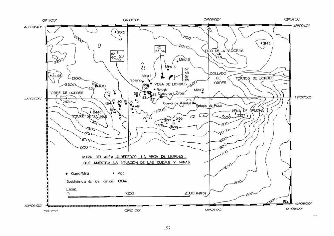
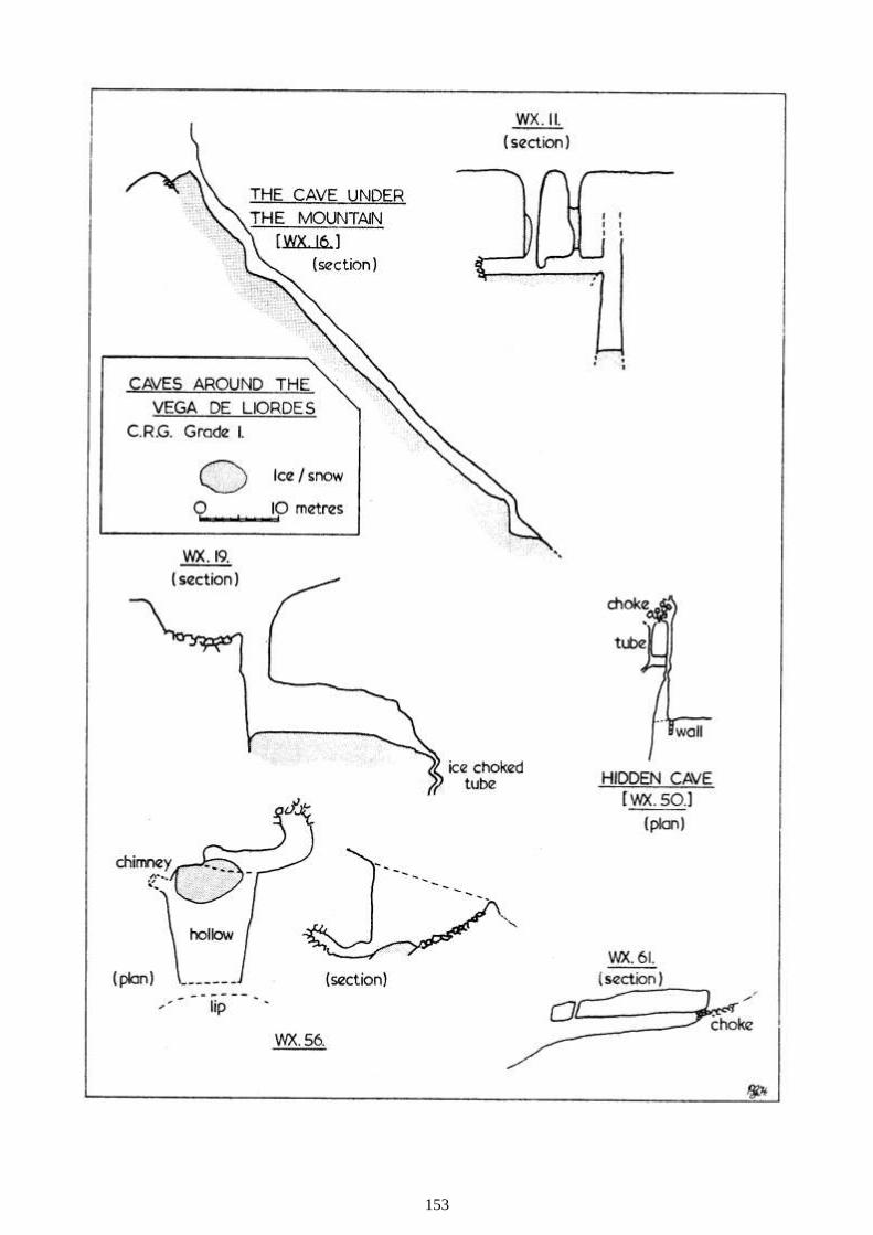
ADIOS LIORDES ? - NOT ON YOUR LIFE.'
by Phil Hendy
Finding caves in the boulder-strewn wastes around the Vega de Liordes in Spain's Picos de Europa was
ludicrously easy. We spent a lot of time just walking around the mouths of shafts simply to reach
predetermined sites. Frequently, caves were found and refound; more annoying was the waste of time in
exploring them twice. With only limited time at our disposal, the 1974 Wessex Expedition to the Picos
had to do something to prevent this - and a pot of paint was purchased. Armed with our scarlet pigment
and a brush if we were lucky (or fingers if we weren't) we boldly marked the entrance of each new
discovery with a number, prefixed W or WX. After identification came location, and bearings were taken
from each site to a number of prominent landmarks, using a handheld Suunto compass and clinometer,
reading to the nearest 0.5 degree.
It had been intended to produce a pair of latitudinal and longitudinal co-ordinates for each cave, but the
compounded vagaries of inaccurate maps, local magnetic anomalies and human error made this an
impossible task, The sketch map reproduced here does no more than show the approximate location of the
majority of sites found. However, with the exception of a few pots described below, all marked caves
have been fully explored, so future parties working in the area need not bother with any cave showing a
splash of red paint at its entrance.
Most of our finds were vertical pots of varying size and depth. They descend through finely fluted and
jagged limestone to snow plugs or boulder chokes. Their depths were estimated from the length of rope
needed to bottom them, and the absence of any kind of accurate measurement means that the sketch
surveys of a few of the more interesting holes are to Grade 1 only.
The majority of caves were discovered by randomly walking the lapiaz, although it soon became plain
that certain areas were more fruitful than others. Yet the chance find must not be underrated. WX 100 was
passed close by on no less than seven occasions before it was discovered!
The sites described below are roughly classified by location, a doubtful parameter but the only one
available. Aerial photography, or an accurate ground survey would be needed to show the relation the
caves really have to each other.
CAVES OF THE VEGA DE LIORDES
All water entering the Vega, whether from the stream which rises from mining spoil below the col, or
seepage from the scree at the bases of the encircling mountains, eventually finds its way into the Cueva de
Liordes. The discovery and exploration of this major swallet has been described in a previous Journal,
and any extensions to the system will have to be made by digging or diving. However, some 30m higher
than this swallet, and clustered below the whaleback to the north of the Vega, lie seven small swallets,
which when found were either dry, or taking a tiny volume of seepage water. Four of these holes lay at
the edge of humped limestone outcrops, rising from the short turf. A little gardening in two of them
allowed access to short drops, ending in level mud floors. Another hole was dug for a while; an estimated
5m drop just inside the entrance was never proved as a slipping boulder inextricably jammed itself in the
slot. The fourth swallet of the group had a well-defined water-level mark on the limestone, while 1.5m
below was a static muddy pool among boulders.
Nearby, but 10m lower down the hill, lay WX 66, the Hoyo de Uve Verde (Green Vee Swallet) named
after the two converging patches of waterlogged moss which fed it with a slow drip. Five minutes work
with a peg hammer, and we were able to free-climb down a fluted 7m shaft to a boulder floor. A rift led
from the bottom for 1.5m before it too choked. The remaining two swallets in the area were merely steep
depressions in a shallow dry and grassy stream bed.
148
CAVES UNDER THE PEÑA DE REMOÑA
Our exploration of this inner wall of the Vega was effectively hindered by the deceptively steep rock.
Only three caves were found here, the largest and most impressive being the Boca (Mouth) de Alcacero,
affectionately known as the Gob. Its exploration has been described elsewhere, but the size of this cave at
such an altitude led to much speculation. Although the ice plug prevents downward exploration, a search
of the south side of the ridge might lead to the discovery of old outlets.
Two caves of much smaller dimensions were found lower down. The Refugio de Roca (Rock Shelter) is
no more grand than its name implies, but the adjacent Cueva de Rendija (Rift Cave) provides 23m of tight
ascending rift passage before a short phreatic tube ends in an impassable slot, beyond which is a 3m drop.
The cave's unpleasantness was enhanced by the many small flies and tiny needle-sharp stal.
To the east, and still lower down, Mina (Mine) 2 was found, at the back of a small retaining wall and
platform of spoil. A 2 x 1.5m passage ran straight into the hillside, but a deep pool extending as far as we
could see deterred exploration, clad as we were in shorts and walking boots. Judging from the size of the
spoil heap, the adit cannot be very long.
In a grassy hollow near the col and at the foot of Remoña, two dry swallets were found. Lack of time
prevented us from removing the few obstructions blocking access to negotiable passage, but this task has
a high priority for the 1975 expedition - by which time those sheep carcases should be less pungent!
CAVES ABOVE THE WHALEBACK
Behind the Refugio, a steep wall rises from the floor of the Vega to enter a wide boulder strewn pass
between the Picos de Friero (including the Torres de Salinas and de Liordes) to the south, and the Torre
Blanca - Pico de la Padiorna range to the north. Many small caves were found here, four being
straightforward shafts 2 - 8 m deep (WX 52, 53, 58 and 60. The former is not shown on the map, but is
almost directly above WX 50). The cave marked Sotano (Shaft) was a 7m deep rift with a lower bedding
plane entrance, both openings connecting to enter a small unstable chamber. WX 59 was a 2.5m shaft
which led to a small passage ending in a chimney which connected with the surface via a bedding plane.
The Cueva Oscuro (Hidden Cave, WX 50) was concealed behind a stone wall. A roomy vestibule, used as
a shelter, led to a twisting rift, until after 17m an unstable boulder choke was traversed to end in a
draughting but impassable slot. A phreatic tube led off from a bedding plane near the entrance and
presumably entered the choke at a higher level. This was never proved, since the sharp needles of stal on
the surface of this tube prevented access. They nearly prevented egress as well!
The short bedding plane of WX 51, and the earth-floored tube of WX 57 were quickly explored, and
found to be of no consequence. However, 7m from the latter lay WX 56, which was entered by crossing a
small snow plug at the back of a large square depression in the hillside. The low wide entrance descended
gently to the right, and then ascended over boulders to the left to end in a choke.
The two blocked shafts of WX 54 and 55 were found in a small boulder-strewn gully. One had an
estimated depth of 7m, but lifting tackle would be necessary to remove the obstructing boulders. A wide
but shallow (8m) mine working, Mina 1, was also found in this area, cut along a band of reddish
mineralised rock. Minas 3 and 4 were 2m square adits, cut into the face of the whaleback, and were only
33m long, ending in blank walls. Since they are much used as latrines by the cattle, it was left to your
chronicler to enter their portals and explore them.
CAVES UNDER THE TORRE DE SALINAS
The two peaks, the Torres de Salinas and de Liordes, hem in the cwm of the Hoyo de Liordes, and their
walls appear to be vertical. A sloping crack in the former, high up in the Hoyo, seemed to have caves
149
formed along its length, but no-one climbed high enough to confirm this. Further downhill, three caves
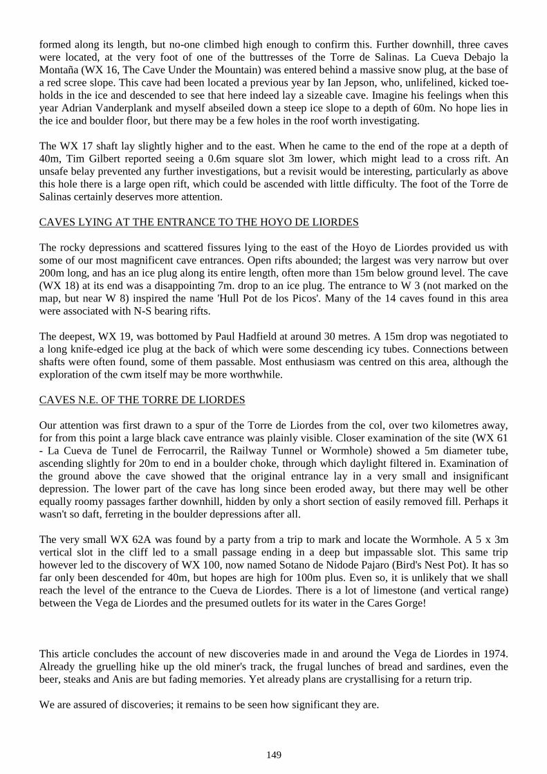
were located, at the very foot of one of the buttresses of the Torre de Salinas. La Cueva Debajo la
Montaña (WX 16, The Cave Under the Mountain) was entered behind a massive snow plug, at the base of
a red scree slope. This cave had been located a previous year by Ian Jepson, who, unlifelined, kicked toe-
holds in the ice and descended to see that here indeed lay a sizeable cave. Imagine his feelings when this
year Adrian Vanderplank and myself abseiled down a steep ice slope to a depth of 60m. No hope lies in
the ice and boulder floor, but there may be a few holes in the roof worth investigating.
The WX 17 shaft lay slightly higher and to the east. When he came to the end of the rope at a depth of
40m, Tim Gilbert reported seeing a 0.6m square slot 3m lower, which might lead to a cross rift. An
unsafe belay prevented any further investigations, but a revisit would be interesting, particularly as above
this hole there is a large open rift, which could be ascended with little difficulty. The foot of the Torre de
Salinas certainly deserves more attention.
CAVES LYING AT THE ENTRANCE TO THE HOYO DE LIORDES
The rocky depressions and scattered fissures lying to the east of the Hoyo de Liordes provided us with
some of our most magnificent cave entrances. Open rifts abounded; the largest was very narrow but over
200m long, and has an ice plug along its entire length, often more than 15m below ground level. The cave
(WX 18) at its end was a disappointing 7m. drop to an ice plug. The entrance to W 3 (not marked on the
map, but near W 8) inspired the name 'Hull Pot de los Picos'. Many of the 14 caves found in this area
were associated with N-S bearing rifts.
The deepest, WX 19, was bottomed by Paul Hadfield at around 30 metres. A 15m drop was negotiated to
a long knife-edged ice plug at the back of which were some descending icy tubes. Connections between
shafts were often found, some of them passable. Most enthusiasm was centred on this area, although the
exploration of the cwm itself may be more worthwhile.
CAVES N.E. OF THE TORRE DE LIORDES
Our attention was first drawn to a spur of the Torre de Liordes from the col, over two kilometres away,
for from this point a large black cave entrance was plainly visible. Closer examination of the site (WX 61
- La Cueva de Tunel de Ferrocarril, the Railway Tunnel or Wormhole) showed a 5m diameter tube,
ascending slightly for 20m to end in a boulder choke, through which daylight filtered in. Examination of
the ground above the cave showed that the original entrance lay in a very small and insignificant
depression. The lower part of the cave has long since been eroded away, but there may well be other
equally roomy passages farther downhill, hidden by only a short section of easily removed fill. Perhaps it
wasn't so daft, ferreting in the boulder depressions after all.
The very small WX 62A was found by a party from a trip to mark and locate the Wormhole. A 5 x 3m
vertical slot in the cliff led to a small passage ending in a deep but impassable slot. This same trip
however led to the discovery of WX 100, now named Sotano de Nidode Pajaro (Bird's Nest Pot). It has so
far only been descended for 40m, but hopes are high for 100m plus. Even so, it is unlikely that we shall
reach the level of the entrance to the Cueva de Liordes. There is a lot of limestone (and vertical range)
between the Vega de Liordes and the presumed outlets for its water in the Cares Gorge!
This article concludes the account of new discoveries made in and around the Vega de Liordes in 1974.
Already the gruelling hike up the old miner's track, the frugal lunches of bread and sardines, even the
beer, steaks and Anis are but fading memories. Yet already plans are crystallising for a return trip.
We are assured of discoveries; it remains to be seen how significant they are.

150
Au revoir, Liordes - it will be a long time before we can say Adios.
REFERENCES
Hanwell, J.D. (1972) The Picos de Europa and the Vega de Liordes. J. WCC 12. 143, 139 - 140.
Hanwell, J.D., and Davies, F.J. (1972) The exploration of the Cueva de Liordes in Spain, August 1971. J.
WCC 12, 143 142-154.
Hendy, P.G. (1974) I will life up mine eyes unto the hills....again! J. WCC 13 156 121-7.
NOTE
Greater detail concerning the discoveries made in 1974 is being collected into a file containing the
accounts of all Wessex exploration in Spain. This will in due course be placed in the Library at Upper
Pitts.
Phil Hendy will be showing slides of the 1974 Expedition to Spain at Upper Pitts on the evening of
Saturday April 5th. Members with their own slides of previous expeditions are welcome to bring them
along. (A Kodak Carousel will be available).
151
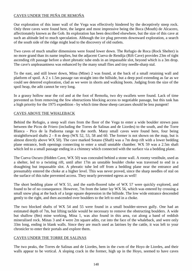
←
Paul Hadfield checking a
belay, somewhere under
Spain.
Photo A.D.N.
Aubrey Newport
prussiking out of the
Cave under the
Mountain
Photo P.G.H.
↓
152
153
154
MENDIP’S LONGEST CAVE
by W.I. Stanton
On April 1 1974 the Bristol Avon River Authority merged with many other organisations to form the
giant Wessex Water Authority, which rules, water wise, over most of Somerset, Dorset, Wiltshire and the
bastard Avon. Though administrations change, problems stay much the same, and BARA's Mendip water-
tracing programme is continuing under the new management. The purpose of the investigation is to
increase our understanding of one of the region's most important aquifers, especially in respect of the
causes of water pollution and the effect of sub-water-table quarrying on water resources. The former has
been particularly troublesome in the Stoke Lane district, and the latter will revolutionise underground
drainage east of Stoke Lane.
In January of this year the East Mendip work seemed to be making little progress. Seeking light relief, I
turned for quick results to a group of swallets with an obvious resurgence. Three small streams and one
fairly large one drain the east flank of the Eaker Hill sandstone pericline, entering swallets that do not
appear in the "Complete Caves of Mendip". They are:-
Tor Hole Swallet CM 57415203 A690 West end of Tor Hole Minery. Swallet at northeast corner of lower
Bishop's Pond (constructed by ore-washers) takes the pond overflow, in winter a large but variable
stream.
Minery Cottage Swallet CM 57585202 A690 Tor Hole, 50 yards northeast of Minery Cottage, under wall.
Small stream from roadside springs seeps away in soft ground at the south edge of the Tor Hole Minery.
Long Wrangle Swallet CM 57655188 A725 Tor Hole, 150 yards southeast of Minery Cottage. Small
stream seeps gradually underground as it crosses a field.
Adam's Grove Swallet CM 57935185 A725 Tor Hole, near remains of farm buildings at Adam's Grove.
Stream seeps underground at edge of field.
The obvious resurgence was Chewton Mendip Rising, 2.7 km away in the down-dip direction and about
240' lower. Other possibilities were Sherborne Spring and the borehole at Pullin's Dairy at Ford (591537).
Chewton Mendip seemed more likely than Sherborne as it was closer, and its flow, like that of the
swallets, shows great seasonal variation, but the gradient to Sherborne is steeper. All three possibilities
were sampled.
Permission was obtained from Waldegrave Estates Ltd., and on January 8 0.5 kg of fluorescine was
poured into Tor Hole Swallet (flow c.300 gallons per minute) and 130 cc Rhodamine WT into Adam's
Grove Swallet (c.60 gpm). On January 10 124cc of Rhodamine WT went into Long Wrangle Swallet
(c.30 gpm) and the same amount was added to Minery Cottage Swallet (c.20 gpm) on January 12. This
attempt to obtain 3 separate Rhodamine peaks was based on my confidence that travel time to Chewton
Mendip would not be more than 24 hours.
Six days after first input the samples were analysed. There was no dye in any of them. Somewhat
shattered by this, I sampled Wookey Hole, Cheddar and Rodney Stoke resurgences for 8 days, in the hope
that if the dye had gone to these more distant springs it might still be coming through. And in fact the
samples from Cheddar (First Feeder) showed what seemed to be a very small Rhodamine peak, plus the
tail end of the one before it. I interpreted these as caused by the dye from Minery Cottage and Long
Wrangle Swallets.
It was necessary to check this result, so on January 22 750 cc of Rhodamine WT was poured into Tor
Hole Swallet. Stage had fallen considerably and flow was c.60 gpm. Next day the opportunity was taken
to add 600 grams of the unreliable dye Pyranine to the small (c.10 gpm) stream entering Bowery Corner
155
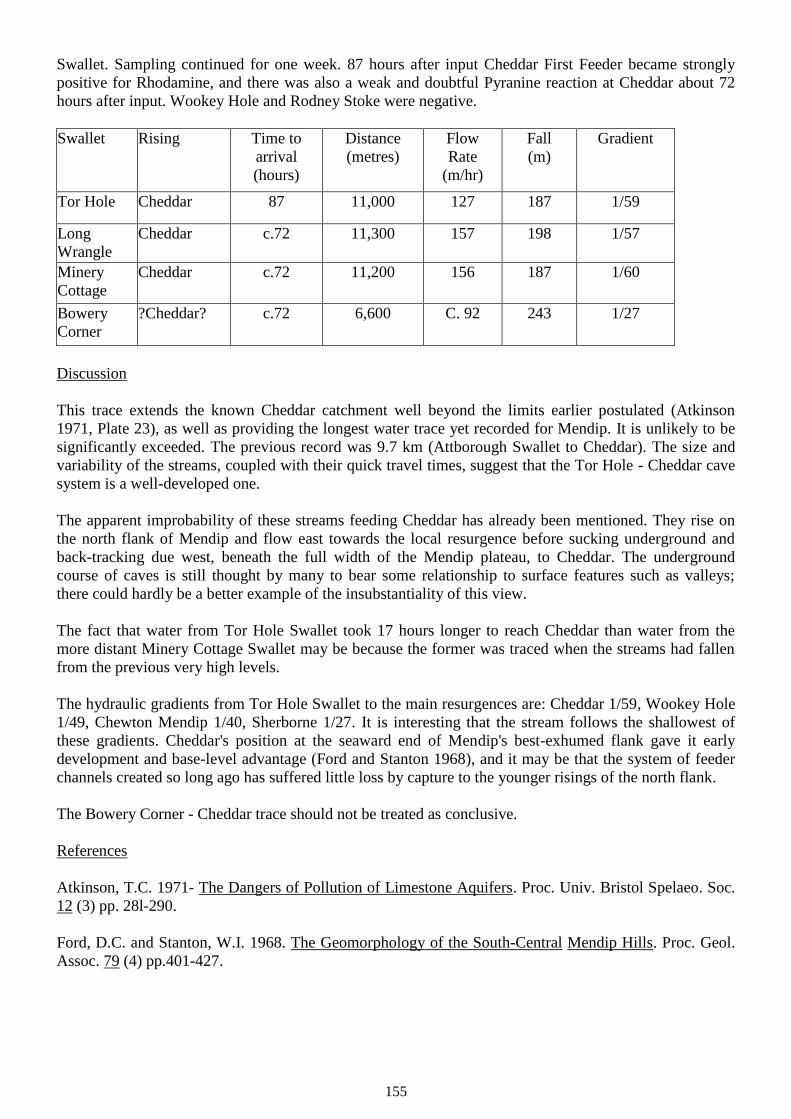
Swallet. Sampling continued for one week. 87 hours after input Cheddar First Feeder became strongly
positive for Rhodamine, and there was also a weak and doubtful Pyranine reaction at Cheddar about 72
hours after input. Wookey Hole and Rodney Stoke were negative.
Discussion
This trace extends the known Cheddar catchment well beyond the limits earlier postulated (Atkinson
1971, Plate 23), as well as providing the longest water trace yet recorded for Mendip. It is unlikely to be
significantly exceeded. The previous record was 9.7 km (Attborough Swallet to Cheddar). The size and
variability of the streams, coupled with their quick travel times, suggest that the Tor Hole - Cheddar cave
system is a well-developed one.
The apparent improbability of these streams feeding Cheddar has already been mentioned. They rise on
the north flank of Mendip and flow east towards the local resurgence before sucking underground and
back-tracking due west, beneath the full width of the Mendip plateau, to Cheddar. The underground
course of caves is still thought by many to bear some relationship to surface features such as valleys;
there could hardly be a better example of the insubstantiality of this view.
The fact that water from Tor Hole Swallet took 17 hours longer to reach Cheddar than water from the
more distant Minery Cottage Swallet may be because the former was traced when the streams had fallen
from the previous very high levels.
The hydraulic gradients from Tor Hole Swallet to the main resurgences are: Cheddar 1/59, Wookey Hole
1/49, Chewton Mendip 1/40, Sherborne 1/27. It is interesting that the stream follows the shallowest of
these gradients. Cheddar's position at the seaward end of Mendip's best-exhumed flank gave it early
development and base-level advantage (Ford and Stanton 1968), and it may be that the system of feeder
channels created so long ago has suffered little loss by capture to the younger risings of the north flank.
The Bowery Corner - Cheddar trace should not be treated as conclusive.
References
Atkinson, T.C. 1971- The Dangers of Pollution of Limestone Aquifers. Proc. Univ. Bristol Spelaeo. Soc.
12 (3) pp. 28l-290.
Ford, D.C. and Stanton, W.I. 1968. The Geomorphology of the South-Central Mendip Hills. Proc. Geol.
Assoc. 79 (4) pp.401-427.
Swallet Rising Time to
arrival
(hours)
Distance
(metres)
Flow
Rate
(m/hr)
Fall
(m)
Gradient
Tor Hole Cheddar 87 11,000 127 187 1/59
Long
Wrangle
Cheddar c.72 11,300 157 198 1/57
Minery
Cottage
Cheddar c.72 11,200 156 187 1/60
Bowery
Corner
?Cheddar? c.72 6,600 C. 92 243 1/27
156
GOATCHURCH SCRUBBING SESSION
by Colin Rogers
Following a letter published in "Descent” inviting cavers to join the St. Albans Caving Scouts for a clean-
up of Goatchurch, Clive North contacted their leader, David Holton, and suggested to me that I brought
along some Axbridge "volunteers". Efforts were to be concentrated on restoring the Water Chamber, and
the date chosen was Saturday, 11th January 1975.
One of the experiments we are currently engaged on is the "Litter Bag Experiment" (see advertisement in
this Journal. Ed.) and so it was fitting that cave conservation should have brought our groups together. As
soon as they saw our bags and grasped the concept, they kitted themselves likewise and ordered more for
their members at home. Our equipment had been well chosen and fitted the purpose admirably. Buckets
could be filled with water at the rate of two per minute in the Water Chamber, and a bicycle pump
facilitated easy washing of roof graffiti.
The main problem was to clean off the recent addition of aerosol spray paint without damaging
formations or being any more hostile to the microflora than was necessary. Fortunately most damage was
an old broken rock with compacted mud coatings; thus from the point of view of we human "temporary
troglophiles", the habitat was improved by the application of our wire brushes. Actual pristine patches of
substrata were revealed, reminiscent of the lower chambers of Banwell Bone Cave.
Water was by far the best lubricant for removing the paint, and a number of experiments prior to the
clean-up showed that solvents like Acetone only helped the paint to soak in, besides filling the cave with
inflammable vapour. When cleaning stal. water and the abrasive nature of ochre enabled paint and carbide
soot to be removed without leaving anything chemically foreign in the cave. Upper walls were cleaned by
small Axbridge members, perched on the shoulders of larger "scrubbers", while the roof was washed by
hanging the cleaner on a pair of arboreal bracers.
On leaving the cave we collected rubbish along the way. About half a dozen buckets of detritus were
removed, and perhaps our most unusual find was an old umbrella stuffed in a crevice in the Water
Chamber, Much still remains to be done in the cave, but anyone visiting the Water Chamber should at
least notice the difference.
What good did we do for cave life? Probably none at all, but I damned sure we did more for its future
than many of the conferences I’ve attended. The general view seems to be - "Who cares about
Goatchurch? Let them destroy it. It will keep them away from the rest". I fail to see the logic in this, and
anyone who has worked with school maintenance etc, will know that graffiti collects graffiti, and equally
that things well looked after will usually be respected by visitors.
Cave conservation can always do with some propaganda, and the Goatchurch episode was the subject of a
news item on the BBC's Points West programme on the following Monday. The newsreel was shot by
Clive North. All publicity is good publicity, so they say.
LETTER TO THE EDITOR
Sir,
Karst Iron Rules of Hydrology, or Carry on Calculating
It is very flattering for one’s published work to attract the attention of one so eminent as your scribe
Willie Stanton, who has reviewed a paper by Dave Drew and myself summarizing our researches on the
groundwater hydrology of the Mendips. ("Underground Drainage of Limestone Catchments in the
Mendip Hills", Special Publication of the Institute of British Geographers, (6). Reviewed in W.C.C. Jnl.
157
13, (156), pp. 139-140). Since Willie has treated some of our calculations with a slightly mocking
scepticism, I should be grateful if you would allow me to discuss some of the points raised in his review.
The first question Willie raises is that of possible leakage of ground-water from the Old Red Sandstone,
through the largely impermeable Lower Limestone Shale and into the Carboniferous Limestone. No
doubt he believes that such leakage occurs in any case, but in his review he interprets our figures as
indicating that four fifths of all the water leaving the Old Red Sandstone areas does so as leakage, and
only one fifth as streamflow. The figures in question are weekly measurements of the flow of swallet
streams, which indicate that only 3% of the flow from Wookey Hole and Cheddar springs is derived
directly from swallets, whereas about 15% of the catchment area of these springs feeds directly into
swallets. Now the discrepancy between these figures need not necessarily be due to the remaining Old
Red Sandstone water percolating underground and reaching the limestone by leakage. The measurements
of streamflow were taken weekly, and in such small, flashy streams as these weekly measurements will
be strongly biased in favour of the low flows and a great deal of water may have flowed into swallets
during storms and floods between the times of measurements. It is because of this that Dave and I
deliberately refrained from jumping to the conclusion that Willie has drawn, that all of the unmeasured
water leaks as groundwater across the Lower Limestone Shale, although on pages 97 and 100 of the
original paper we do discuss it in detail, and conclude that it may occur, and probably does in parts of
Eastern Mendip. The acid test of the leakage hypothesis is to calculate water budgets for swallet
catchments using continuous measurement of stream discharge at the swallet. If this shows streamflow to
a great deal smaller than the difference between rainfall and evaporation, then one may reasonably
conclude that leakage is taking place. The only swallet for which such an exercise has been performed so
far is Stoke Lane Slocker and here the water budget showed a near perfect balance, indicating that there
was no leakage of groundwater from Old Red Sandstone to Limestone within the catchment. The data
exist to perform similar calculations for East Twin Brook but the results are not yet known.
I agree with Willie that one can place too much emphasis on obtaining a correct balance of rainfall,
evaporation and streamflow in performing water budget calculations. However, he has surely missed the
point that the water budgets in the paper were carried out in order to test the accuracy of catchment
boundaries which were themselves deduced from water tracing results (p. 95 of the paper). On the whole
the water budgets for the major springs balanced satisfactorily within the errors of measurement or
rainfall, streamflow etc., and we concluded that the boundaries were essentially correct. It now appears
that swallets such as Tor Hole Sinks drain to Cheddar, but the additional catchment area involved in
including them is quite small. There is as yet no reason for extending the boundary of the Cheddar
catchment further to the north, as Willie suggests, and in my view there will not be unless someone traces
Cow Hole or Fernhill Farm Swallet to Cheddar. Ubley Hill Pot, which lies between the boundary of the
Cheddar catchment is drawn in our paper and the northern escarpment, has been tested and drains to
Rickford spring (see "Complete Caves of Mendip", p. 115, 1970 edition).
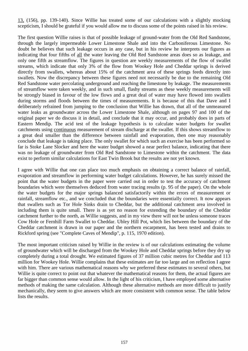
The most important criticism raised by Willie in the review is of our calculations estimating the volume
of groundwater which will be discharged from the Wookey Hole and Cheddar springs before they dry up
completely during a total drought. We estimated figures of 37 million cubic metres for Cheddar and 113
million for Wookey Hole. Willie complains that these estimates are far too large and on reflection I agree
with him. There are various mathematical reasons why we preferred these estimates to several others, but
Willie is quite correct to point out that whatever the mathematical reasons for them, the actual figures are
far bigger than common sense would allow. In the light of his criticism, I have employed some alternative
methods of making the same calculation. Although these alternative methods are more difficult to justify
mechanically, they seem to give answers which are more consistent with common sense. The table below
lists the results.
158
Estimated Volumes of Water in Storage in Spring Catchments
Formula of discharge
recession used
Volume stored in Cheddar
catchment
Volume stored in Wookey Hole
catchment
(millions of cubis metres)
Q=Qo(1 + atb)-1
Q=Qoexp-kt
Q=Qo(1 + ctd)-2
Q=qoexp-mt
Q=qo -nt
37.6
3.8
6.2
3.3
2.3
113
4.4
-
5.3
3.6
Q = discharge, t = time in days, Qo discharge when t = a, b, k, c, d, m, n, are all constants varying from
spring, q = baseflow discharge
For the benefit of those who are interested in such things, the formulae on the left are derived from actual
data on the decline of spring flows during dry periods by means of least squares analysis. From each
formula the volume of storage at any given time or discharge can be estimated by integrating the curve of
discharge recession between the discharge concerned and zero, or between the time concerned and
infinity. Normally one would only use the formula which gave the best fit to the known data points. In the
case of Cheddar and Wookey Hole, this was the first one shown above).
The results in the table seem to lend support to Willie's views, and to suggest that the true volumes of
storage are probably around three or four million cubic metres at Cheddar and four or five million at
Wookey Hole. This rather drastic reduction in the size of the estimates does not however affect the main
conclusions drawn in Dave's and my paper. The total volume of water stored in the rocks behind the
springs is large compared with the volumes of phreatic cave passages suggested by pulse wave analysis
(about 100,000 cubic metres at Cheddar). The large difference between these volumes suggests strongly
that the remainder is stored in cracks and fissures in the rocks. It is because we were driven to this
conclusion that the Karst Police have recanted and would now support the concept of some sort of water
table in the limestones.
Without going into detail here, it does seem that these new estimates of groundwater storage are
compatible with everything else that is known about the limestone aquifer. They can easily be fitted into
the volume of limestone above the springs and below the water table and there seems no need at this stage
to suppose that very much of the stored water is in fact to be found in the Old Red Sandstone. Until we
are sure that there is really significant leakage from Old Red Sandstone to Limestone, I prefer to think of
the two as separate aquifers. Willie may disagree, and may yet prove to be right, as he has so recently
done over the water table.
Yours faithfully,
Tim Atkinson
82 Onley Street,
Norwich.
159
REVIEWS
Caves of the Bristol Region by D.P. Mockford and A.J. Male. Bristol Cave Register (1974) 50p.
The title of this cave guide conjures up a mental image of the Avon Gorge, but although this area features
prominently, Messrs. Mockford and Male have not been content to rest there. The sites listed range from
the shores of the Bristol Channel to the Wiltshire village of Slaughterford, and from Butcombe, on the
edge of Mendip to Tormarton in south Gloucestershire. Within these bounds the authors list 94 holes, no
less than 45 being in the Avon Gorge. Sites range through shafts, caves and resurgences, to shelters, sea
caves and mines. Coal mines are omitted, probably because they are of little speleological interest.
The caves are dealt with in "Caves of Mendip" style with 8-figure map references, and altitudes, lengths
and vertical ranges expressed in metres. Most but not all caves, are given a generalised location, and
where appropriate, details of access. An irritating inconsistency.
Having been asked to review the guide, I felt that the best test of its usefulness would be to use it to
explore a cave which I had never heard of before. Accordingly I selected Rusland Farm Pot at Butcombe.
The puzzled farmer said that I could descend the cave, "if you really want to", and the entrance was duly
located. The "23m deep shaft" was easily descended with a 50' ladder, although I was able to confirm the
existence of "rotting animal remains". An extensive search for an "even larger chamber 90m long" was
fruitless, as the cave ended after 30 yards.
Having highlighted an erroneous conversion from feet to metres, it was easy to find other faults with the
guide. One cave is described twice under different names, certain map references are wrong (one cave
being displaced by 2 km) and Mercavity Cave is credited with a 6m pitch. This latter error originates from
a "spoof" article in an SVCC newsletter.
It is easy to criticise the efforts of others, but these cardinal errors should not have been allowed to occur.
During the course of the three years of preparation, the authors should have visited each site to check their
facts; the published word should not be relied on. Secondly, proof reading requires minute attention to
detail, especially where map references and tackle details are concerned.
Having made my criticism, I congratulate the authors for making an effort to produce a guide book for
this underrated area. For all its inaccuracies and undoubted incompleteness, a "Caves of the Bristol
Region" has been needed for some time. The booklet should stimulate the interest of Bristol-based cavers
at least, in the limestone cavities lying on their own doorstep. This is what really matters; corrections and
additions will naturally follow on later.
P.G.H.
Caves by Tony Waltham. 240 pp. Macmillan. 1974. £4.95
Following his impressive contribution to the Limestone and Caves series Tony Waltham comes into print
again with this fine glossy publication. Essentially a book of pictures, it has a clear text aimed possibly at
those with a limited knowledge of caves, but it is none the worse for that.
The photographs are of a very high standard, many of them in colour, and they illustrate every aspect of
caves. A number of them are familiar but many appear for the first time - the shot looking up the Epos
Chasm must surely be one of the finest underground photos ever taken.
My criticisms are really trifles. I cannot think that all cavers will share Tony's opinion of the impending
commercialisation of the Pierre St. Martin as "magnificently grand" and "a fabulous scheme". Some may
have reservations about this further encroachment on Nature's wild places. British caves are well
represented in the illustrations but the casual reader might be forgiven for thinking that Mendip does not
160
contain its fair share of sporting caves - fine as the great Yorkshire systems are.
However, as I have said, these are niggling criticisms of a well produced and presented book. A
worthwhile addition to anyone's library for the photos alone.
S.M.K.
FROM THE LOG
23rd November 1974 RUSLAND FARM POT
Butcombe N.G.R. 51606310. P. Hendy and A. Vanderplank. See Farmer Ware at farm N.G.R. 513629.
Take track SW from farm at N.G.R. 513633 for 100 yards, then diagonally across field to two barns. Cave
lies along hedge 200 yards from these, under small trees. Remove corrugated iron, tie 60' ladder to trees.
First 10' is large collapse in earth, then ladder enters rift, with low bedding plane going off on right.
Awkward here as ladder goes down narrow crack, but rift itself is quite large. At bottom (about 50' -
beware falling earth) land on body and tin ruckle - many dead animals, rotting nicely. A good cave for
Elsan Cave Club trips! To the left at the bottom, the rift narrows, and one climbs through rotting calves
etc., breathing the sweet perfume of decaying flesh. After doing this one finds oneself in a small boulder
ruckle with no way on. So one climbs back up through the indescribable, and back down over the other
side of the body ruckle, ankle-deep in festering juices, and then up a stalled-up boulder pile into a red
passage with stal. flows, stalactites and curtains. It is possible to climb down into the boulders, but you
don't go anywhere. Out quickly, gagging and retching. Yours truly nearly peeled off the ladder, but
Adrian was lifelining - that's why I didn't peel! Smelling evil, back to Upper Pitts for a shower and a dip
in disinfectant.
N.B. Farmer Ware is very friendly. Very surprised that we wanted to go down - the last visit was 6-10
years ago. I understand why. The cave was used during the war to dispose of offal from a nearby illicit
slaughterhouse, and is used to this day for carcase disposal. Worth a visit but not a return trip. Must go
now, I want to honk.
H.F.
29th/30th November 1974 MANOR FARM
Al Mills, Alb Wilkins and Dook Mills to muddy rift at the end of Manor Farm. Banged dig. Alb Wilkins
and Dook Mills returned the next day to find the bang successful but with a big boulder still to be
removed before progress can be made. The fumes were still very strong, proving that there is little
draught at the far end of the cave?
Anon.
7th December 1974 LONGWOOD SWALLET
Enormous party (about 15) to Longwood for rescue practice. Casualty was brought:
1) Down from Upstream Galleries to bottom of Fault Passage
2) Up Fault Passage and Swing Pitch (relatively simple)
3) From base of 10' drop as far as foot of entrance shaft
Main problems (contrary to our anticipation) were negotiating the lip of the 10' drop, and the bedding
plane below the entrance. A person with serious injuries, and unable to assist him/herself anywhere
beyond these sections would be at very serious risk. How to deal with such an event I frankly have no
161
idea. Does one ignore the injuries and move quickly at the risk of aggravating them? Does one take
extreme care, at the expense of time? It is certain that a large individual could not be removed all the way
in a rigid carrying device.
P.G.H.
14th December 1974 ASSOCIATES POT
Chewton Rabbit Warren N.G.R. 54915122. M. Voice. Dived in Pot but found it blocked about five feet
down by a large boulder in the rift.
M.V.
14th December 1974 EASTWATER
Jeff Price and Ben to dig in Terminal Rift. Ben digging away merrily in newly discovered aven suddenly
heard . . . .Plop . . . Plop . . . Plop. Appearing from a hole to the right there was a mini avalanche of liquid
mud. At the same time the floor of the Terminal Rift completely collapsed. Work continues in the new
hole.
'B. '
21st December 1974 THRUPE LANE
Bob Pyke, Steve Stanwix, Bob Lewis. At Atlas Pot RP descended by usual (left-hand) ladder and
proceeded to free climb the top 40' from the ledge. Tackle then transferred to right-hand side, feeding the
ladder through the crack on the right- hand side of the pitch at the head of the pitch. Contrary to my
previous belief this simply gives another way down Atlas. As a means of descent this has the advantages
of ease of climbing and absence of water. With a correctly placed header-rope it can be done on about 80'
of ladder. Lifeline advised for take-off.
R.G.
21st December 1974 EASTWATER
Jeff Price and Ben to dig in Terminal Rift, We removed one hundred buckets of shit and a small hole
appeared looking very promising for future trips.
J.P.
28th December 1974 WITHYBROOK SLOCKER
I.J. and P.G.H. met the Belgians after they had toured Shatter Cave. Intended to do Stoke but it was
raining and water was 2" from top of entrance so we decided against. St. Dunstan's Well fairly chucking it
out, fast and muddy. As a last resort over to Withybrook Slocker. I dug out entrance and descended 6' in
full force of stream. Way on obscured by this water so I emerged. Paul Hadfield went as far, then came
out in time to see PGH playing at shoring up 5-6 cwt of rock which had decided to peel from the wall. We
were then able to watch some boulders rattle into the hole where Paul had had his head a minute before.
Trip abandoned. (Never in my caving career have I made so many attempts to go caving and failed, the
Gods were against us).
P.G.H.
162
LITTER BAG EXPERIMENT
These are robust pouches that a number of us wear (every month we are more).
The holder considers them as important as a light - or a helmet.
BASIC ) LIGHT
EQUIPMENT ) HELMET
) LITTER BAG
Litter bags are small and most people find them unobstructive to wear (more find this each month). When
we go caving, outsiders say things like:-
"Am I glad to see that"
but some say
"Codswallop! I use my pockets"
Either way we are glad. It's hardly the atmosphere for the 'Litter Bug' (each month the atmosphere grows).
Every bag is different; everyone is registered against the holder's name. If a litter bag is ever lost, it must
be declared in the Axbridge Newsletter. If one (or part of one) is found, the owner's name will be declared
in the Axbridge Newsletter. But then - only responsible people wear litter bags.
"Why do we wear them"?
"It's a conservation experiment"
(every month we write 'Positive')
"If it was a rescue, would you leave it"?
"It's attached to my light"
"Where do I get one"?
"29 Cleeve Road, Knowle, Bristol, BS4 2JR - especially on a last Tuesday of the month after
8.30"
"How much"?
"I don't charge - but donations are welcome".
Axbridge Caving Group Colin Rogers.
Recommended