A study funded by the Project LIFE10 NAT/CY/716
“Restoration and Management of Oroklini Lake”
Ichthyological Study
for Oroklini Lake, Cyprus

Ichthyological Study for Oroklini Lake. BirdLife Cyprus; Final Report 2014.
2
Bibliographical Citation:
Zogaris,S. 2014. Ichthyological Study for Oroklini Lake. April 2014. BirdLife Cyprus. A
Study within the Project LIFE10 NAT/CY/716 ‘Restoration and Management of Oroklini Lake
SPA, Larnaca’.Unpublished Final report, 58 pp. Nicosia, Cyprus.

Ichthyological Study for Oroklini Lake. BirdLife Cyprus; Final Report 2014.
3
Table of Contents
3.1 EVIDENCE FROM MAPS AND COMPARATIVE ECOSYSTEMS ....................................................................... 10
3.2 SITE DEFINITIONS AND TOPOGRAPHY OF THE STUDY AREA ...................................................................... 10
3.3 SPATIO-TEMPORAL HYDROLOGICAL AND VEGETATION VARIABILITY ........................................................... 11
5.1 PAST WORK .................................................................................................................................. 14
5.2 CURRENT WORK ............................................................................................................................ 14
5.3 AQUATIC AND SEMI-AQUATIC HABITATS FOR FISHES AT OROKLINI ............................................................ 14
5.4 INVESTIGATING REFERENCE CONDITIONS AT OROKLINI (ICHTHYOLOGICAL ATTRIBUTES) ................................ 18
5.5 ABIOTIC CONDITIONS ...................................................................................................................... 19
5.6 RESULTS OF THE SAMPLING CAMPAIGN .............................................................................................. 21
5.7 ANNOTATED LIST OF SPECIES CURRENTLY INHABITING OROKLINI LAKE WETLAND........................................ 26
6.1 GAMBUSIA HOLBROOKI POPULATIONS AND THEIR MANAGEMENT ............................................................ 31
6.2 APHANIUS FASCIATUS RE-ESTABLISHMENT/ INTRODUCTION IN OROKLINI LAKE WETLAND ............................ 33
6.3 EEL POPULATIONS, MOVEMENT AND ECOLOGICAL REQUIREMENTS ........................................................... 37
6.4 GREY-MULLET (MUGIL CEPHALUS AND LIZA SPP.) MOVEMENT AND ECOLOGICAL REQUIREMENTS .................. 42
6.5 OTHER FISH HABITAT OR FISH SPECIES REQUIREMENTS AND/OR OPPORTUNITIES FOR RESTORATION OR
ENHANCEMENT. ..................................................................................................................................... 43
APPENDIX 1: SUMMARY OF FORMER SAMPLING RESULTS FROM OROKLINI ......................................................... 53
APPENDIX 2: REPORT ON THE FISH KILL EVENT AT OROKLINI, SUMMER 2013 .................................................... 54
APPENDIX 3: EUROPEAN EEL CONSERVATION ON CYPRUS .............................................................................. 56
APPENDIX 4: INDICATIVE MAP RESOURCES .................................................................................................. 57
APPENDIX 5: SITE NAMES USED IN THIS STUDY / TRANSLATIONS ...................................................................... 58
APPENDIX 6: SUΜΜΑRΥ ΙΝ GREEK/ ΕΛΛΗΝΙΚΗ ΠΕΡΙΛΗΨΗ ............................................................................. 58

Ichthyological Study for Oroklini Lake. BirdLife Cyprus; Final Report 2014.
4
1 Project Summary
The Oroklini Lake Wetland is considered one of Cyprus’s most important wetland sites for its
avifauna, its wetland habitats and outstanding cultural values since it is one of the island’s
best places for observing birds. This Natura 2000 site near Larnaca is protected as a Special
Protection Area under the EU Birds Directive and as a Site of Community Importance under
the EU Habitats Directive for its halophytic marsh vegetation. It is a small protected-area,
approximately 85 hectares, primarily composed of seasonally flooded coastal lagoon basin
with Mediterranean salt meadows, tamarisk scrub, reed beds fringed by dry-crop agricultural
land and sprawling recently-build subdivisions. Much of the wetland’s landscape and
upstream catchment has recently shifted from farmland to sub-urban build land, most of the
buildings being built during the last two decades.
This study focuses on the ichthyology of this wetland from a conservation perspective, aiming
to propose specific measures, monitoring and research, which will promote the restoration
and integrative management of the protected area. In brief, the study provides the following
results and proposals:
a) The investigatory ichthyological survey is the first of its kind for Oroklini Lake
Wetland. An initial baseline ichthyological description has been completed yet this is
based solely on a rapid sampling effort during a one year period (Spring 2013-Spring
2014).
b) Research into the reference conditions of the wetland ecosystem is non-existent.
Our on-site investigation strongly suggests that the site is part of a formerly larger
coastal lagoon system. Although the habitat type of coastal lagoon has not been
recognized for the site until now, even today the majority of the so-called “lake” is
structured and functions as a semi-closed coastal lagoon habitat with a definite
connection to the sea by two artificial drainage canals and incoming stream water
inflows. As in most small coastal lagoon formations in the xerothermic Eastern
Mediterranean, this lentic basin is totally dry during most summers creating
encrusted salt-flat conditions (salina-like formations); these are very different from
the flooded brackish/freshwater winter and spring shallow lagoonal pool conditions.
Artificial drainage canals hold water year-round and act as refugia for aquatic
organisms during the drought period.
c) Four fish species use the Oroklini Lake Wetland (including the outlet canals and
ditches). Of these the most important is the European Eel (Anguilla anguilla) and the
non-indigenous Mosquitofish (Gambusia holbrooki ). The other fishes are migratory
Grey-mullets (Mugilids) that mostly reach the out-flowing canals at their lowermost
sections near the sea. As in most Mediterranean small lagoonal wetlands the fish
communities are highly dependent on anthropogenic management and the inner
lagoon basin’s connectivity with the sea. Due to the need for effective wetland
drainage, outlets to the sea have been well maintained.
d) Oroklini is one of the most important areas for the European Eel in Cyprus. Eels
enter through two drainage canals and survive within the lake in the deeper canal
waters and in Oroklini stream (during drought). The numbers of adult Eels surviving
in the wetland is usually in the hundreds (minimum estimate); and, Eels are part of
the food web, fed upon by several fish-eating birds. These populations are very
vulnerable to mass fish-kills if and when total desiccation and/or toxic pollution
affects remnant waters during drought. In 2013 one such desiccation period killed an

Ichthyological Study for Oroklini Lake. BirdLife Cyprus; Final Report 2014.
5
estimated 1200 Eels at Oroklini. However this drought did not kill all the wetlands
Eels and specific habitats were identified that function as refugia.
e) Mosquitofish are considered a threat to local biodiversity as they are a well-known
invasive alien species (IAS). Their impact in Cyprus has not been researched. In
brackish canals and lagoon waters, they practically take up a niche that would
largely be taken by native Cyprinodonts such as Mediterranean Toothcarp (Aphanius
fasciatus). They are adaptive to remarkably harsh physico-chemical changes but do
not survive in long-term saline and hypersaline conditions as the Aphanius do.
Mosquitofish may be important to some birds as a food source (small herons,
kingfishers, terns etc.) and it is known that Eels also feed on them. Based on what
information we have collected, we cannot assess the population of Mosquitofish as
over-abundant or of very high density at Oroklini during the study period of 2013
and 2014, even during the summer season. The presence of Mosquitofish may fill an
“empty-niche” at Oroklini. However, any negative impacts cannot easily be
researched without a special limnological and ecological study.
Recommendation for conservation, restoration, monitoring and research include the following:
a) In terms of the site’s aquatic ecosystem conservation, the protected-area of Oroklini
is very restricted. We urge the protected area be expanded to include surrounding
un-built land and that the waters that feed the lake basin be maintained at level of
good quality. In terms of the need to support the water body’s optimal “ecological
potential” especially when fishes are factored in as elements of the ecological
quality and integrity of the system, Oroklini must function as a coastal lagoon water
body. Despite the fact that what remains at Oroklini is a remnant and degraded
wetland area; management measures can obviously upgrade the wetland for fishes,
supporting refugia for long-lived species and migratory paths up the stream
catchment. It is critical that the water flowing into the basin be of good quality and a
connectivity and flow be maintained with the sea. The conservation value of Oroklini
is obviously heightened if we consider its island-wide value as an important site for
the globally-threatened European Eel. We therefore recommend that the expansion
of the protected-area to a wider area around the lake basin be considered. The two
canals that connect the lake to the sea must also be included in the protected area.
b) Since the wetland is already degraded and affected by anthropogenic changes,
management is critical in enhancing and restoring biodiversity attributes. Some
specific restoration measures that will positively affect the ichthyofauna and up-
grade aspects of the sites ecological integrity include:
- Special care to keep barriers (artificial obstructions) from negatively affecting
incoming migratory fishes.
- Designation and management of “aquatic refugia” during the summer,
particularly in the freshwater flows from upstream during the summer should be
created, maintained and monitored (i.e. especially near the national highway
Oroklini stream entrance into the lake basin and the major deeper canals).
- Specific actions should be taken to protect and transport Eels when times of
drought or extreme drought occur (i.e. applying a protocol for practical
movement of surviving Eels to deeper clean-water refugia within the site).
- Special structures to allow unimpeded movement of Eels should be placed at key
positions were necessary weirs may block Eel movement.
- Research-driven actions for restoration should include efforts to restore a
‘natural’ fish community in the wetland and these may include:

Ichthyological Study for Oroklini Lake. BirdLife Cyprus; Final Report 2014.
6
i. An effort to research the feasibility of the proposed introduction of the
Mediterranean Toothcarp by transplanting native fishes from Akrotiri
Wetland. This may need to include efforts to stop the spread of Mosquitofish
and replace them with Mediterranean Toothcarp in the more saline parts of
the lagoon system;
ii. An in-depth investigation of Eel ecology and survival at the catchment scale
(i.e. beyond the confines of the protected-area). A critical aspect of this study
must include the movement and obstacles encountered by this migratory
species.
c) In our preliminary study, sampling fishes in Oroklini Lake Wetland was done using a
seine net (beach seine type/fry net). Other types of sampling gear should also be
used and recommendations are made for monitoring. An adaptive approach to
monitoring, building knowledge and understanding of the site’s ichthyology should
be designed and implemented.
d) Fishes can become an important ‘conservation icon’ at Oroklini since fishes do affect
the limnology and the food-web (important as a food resources for birds). The
European Eel is a species that is now listed as Critically Endangered (Global IUCN
designation) so special focus should be made to increase public awareness about the
requirements of fishes in this wetland.

Ichthyological Study for Oroklini Lake. BirdLife Cyprus; Final Report 2014.
7
2 Introduction to this study
Fishes are important components of coastal wetlands. Shallow coastal lagoons that maintain
a connection to the sea are usually rich in fish populations. And fishes are keystone
components of these waters’ biotic structure and functioning, often supporting rich food webs.
Natural coastal marshes, lakes or lagoons with a connection to the sea are now a very scarce
habitat in Cyprus.
Oroklini Lake Wetland is a small relict coastal wetland that still maintains a connection to the
sea. Today only a degraded image of its past form exists; much of the area has been
effectively drained and fragmented by modern roads, urban sprawl and recent tourism
infrastructure. However, Oroklini definitely is a very important wetland for Cyprus, certainly
one of the most important on the island with exceptional value for birds and biodiversity in
general, and as a hotspot for building environmental awareness. However, we know little
about the wetland ecosystem’s ecological history and over-all natural history. Not surprisingly,
very little is known about its fishes.
During the development of the ongoing LIFE restoration project at Oroklini questions arose
with reference to the needs of fishes in this wetland. The idea of a specific small-scale study
to review ichthyological information arose while plans for restoration were already under way.
Since the LIFE restoration project aimed at ameliorating habitat for birds while upgrading the
integrity of the wetland ecosystem, it was deemed that knowledge of fish requirements should
also be addressed.
Several pertinent questions posed during discussions with BirdLife Cyprus personnel, with
respect to the fishes of Oroklini, included the following:
• What is the current ichthyofauna of the lake and do we have any information to
compare it to conditions in former times or any type-specific reference baselines?
• How and what should be done to help restore natural integrity for fish assemblages
and their habitat needs; especially with respect to maintaining the ornithological
values of the wetland (and the specific targets of the LIFE Oroklini restoration
project).
• One of the lake’s fishes, the European Eel, is globally threatened (IUCN Critical);
what should be done to protect its populations at Oroklini?
• Another native fish, the Mediterranean Toothcarp (Aphanius fasciatus) is not
present at Oroklini but does survive in two wetlands in Cyprus; should
introduction/re-establishment be considered and how should this be done?
• How do we deal with invasive non-indigenous fish species, especially the invasive
Mosquitofish (Gambusia holbrooki)? This species is widely used as biological control
for mosquitoes. Would Mediterranean Toothcarp be a better and practical
alternative at Oroklini?
• What are the most important parameters of the ichthyofauna that should be
monitored for assessing conservation targets?
All these questions are important, they touch upon conservation and water management
issues and may interest various local non-government and government stakeholders who are

Ichthyological Study for Oroklini Lake. BirdLife Cyprus; Final Report 2014.
8
interested and/or engaged in on-going conservation and water management efforts at
Oroklini. Many of these questions can be answered within a rapid assessment; some cannot
without further research. This final report provides all results of research so far and makes
specific proposals for conservation measures and future research.

Ichthyological Study for Oroklini Lake. BirdLife Cyprus; Final Report 2014.
9
3 Brief historical review of habitat features and potential reference conditions regarding aquatic habitats and fish assemblages
Part of the reasoning for any study considering ecological restoration options for aquatic biota
must involve an understanding of former ecosystem conditions before the site’s
anthropogenic degradation. Research into to the past conditions or of defined favourable local
conditions (i.e. reference conditions) is critically important in order to examine and describe
previous natural or near-natural ecosystem attributes and functioning (i.e. the ecosystem’s
type-specific ‘reference conditions’ before modern human pressures altered the ecosystem).
Knowledge and understanding of distinct biogeographical and biodiversity characteristics of
the site before anthropogenic degradation must be the foundation for ecological restoration
planning.
Oroklini Lake Wetland is a poorly studied in terms of its ecological history; no studies have
adequately addressed the issue of historic changes, reference conditions or ecosystem
baselines. No doubt, Oroklini was heavily degraded by draining schemes put in place at least
since the 1930s (as suggested in Self 2013). The larger part of the coastal wetland area was
effectively drained and the topographically lowest section (lagoon basin) was dry for many
years. The drained basin resembled a dry ‘salt-flat’ for many years, especially during severe
drought years. It may have gone unnoticed due to the severity of the degradation.
As a result, even its history as a recognized important avifaunal site is very recent.
Surprisingly, there is no reference to the wetland even in the first of edition of “The Birds of
Cyprus” (Flint & Stewart 1983) or in a popular birdwatcher’s guide (Oddie & Moore 1994).
Perhaps the site was over-shadowed by more illustrious areas at the time (i.e. Larnaka Salt
Lakes, Achna Reservoir), however the lack of references to such an accessible site point to a
severely degraded state for the site in the recent past. It is possible that for an extended
period in the late ‘80s and early ‘90s the site was totally (or nearly totally) desiccated due to
the prolonged extreme droughts during that period. Whatever the case, it is remarkable that
natural history research interest reached this site so late.
In small wetlands in Cyprus, it is quite normal that a complete natural history description is not
available; and specifically information on the aquatic habitats and particularly knowledge of
the fish is rarely available. In terms of the ichthyofauna, save for a report commissioned by
the Water Development Department (Zogaris et al. 2012), no other work has ever been
published containing field ichthyological research from Oroklini. In terms of the site’s
identification and habitat description and delineation as a Natura 2000 site, we also see a
simple, very recent descriptive work with no effort to interpret habitat types in depth. Although
the site is considered an important wetland area, it must be said that habitat descriptions
practically begun after 2004 and botanical surveys in depth have also been recent (i.e. Gȕcel
et al. 2012). This is the reason why habitat type identification may have been overlooked or
left uncompleted.
A key problem in identifying/delineating aquatic/semi aquatic habitats at a wetland such as
Oroklini is the fact that the site has been heavily modified by wetland drainage schemes that
obviously altered habitats beyond straightforward identification. Furthermore, change at the
landscape scale has been rapid during the last three decades also. Coastal and inland sub-
urban sprawl, road networks, and drainage canals continue to alter natural hydrology at the
site. Development within the basin is ongoing and urban/buildings cover approximately 68%

Ichthyological Study for Oroklini Lake. BirdLife Cyprus; Final Report 2014.
10
of the site’s upstream catchment (IACO 2012). So today, the site is almost a peri-urban
wetland. It is therefore difficult for the naturalist to comprehend what the area was like 50 or
80 years ago. However it is critically important to make correct habitat delineations although
few resources may exist to properly explore this.
Examining older maps and older air photos, and carefully inspecting available hydrological
studies and the local topography we can document and interpret many aspects about the
former wetland conditions of the Oroklini Lake Wetland. Of course some to the following
statements must necessarily be based on expert judgment and speculation but we make clear
were evidence is lacking about certain interpretations. Some of the statements pertaining to
the habitat types involved are policy relevant and may seriously affect wider restoration
planning; and of course this affects proposals for the ichthyofauna as well.
3.1 Evidence from maps and comparative ecosystems
Evidence about the past conditions of the wider Oroklini coastal lagoon formation and its
associated marshlands will not be surveyed in depth in this study. However some available
historic material does show that Oroklini Lake Wetland did have a coastal lentic character at
exactly the same location as today’s “lake” in the late 19th century. This evidence comes from
E. Standford’s 1887 map which shows a large coastal lentic water body behind the shores
near Oroklini (northeast of Larnaka) and this is the only data we have of this kind of water
body at the site (Appendix 4, Fig. 5). Other maps do not exactly show a wetland at Oroklini
since the island-wide scale is not appropriate to show such a small wetland. However,
lagoon-like limnosystems were more widespread and larger along the coasts in former times
and this is easily evident on the older maps (see Appendix 4, Fig. 4). The island’s former
coastal lagoon formations obviously had typical Mediterranean island lagoon ecosystems.
Since we are now considering a coastal lagoonal character; in our assessment this must
typically include many fish entering the areas inland waters seasonally. On Cyprus, this is still
evident at the Amochostos-Enkomi lagoon systems where large numbers of marine migratory
fishes still enter the lagoonal water bodies. The Larnaka Salt lake limnosystem can also be
used as a local model comparison. It is also a degraded coastal lagoon habitat barred by
artificial and natural barriers to its connections with the sea.
3.2 Site definitions and topography of the study area
In terms of the above definition as a ‘degraded coastal lagoon system’ we recommend the
name of the site focus on wetland character and be called “Oroklini Lake Wetland” (contra
Oroklini Lake). Many lagoon habitats are frequently called ‘lakes’ in many Mediterranean
countries. However a wider “wetland site” designation is more accurate in this situation since
the site is more than a strictly defined lentic body, it includes fringing wetlands, drainage
canals and riparian lands that are integral components of its ecosystem features. This
includes the wetland north of the National highway (Kambos Wetland) which is hydrologically
directly connected and “feeds” the “Upper Lake Basin” with water. Lastly, the Oroklini “lake
area” proper can be divided for interpretation purposes into two: The Upper Lake Basin (S3
compartment) which artificially stores water behind an artificial embankment (and sluice) and
the Lower Lake Basin (S6 and S7 compartments). The Lower Lake Basin is crossed by three
major drainage canals and remains as a lagoonal salt-flat during much of summer and
autumn. Figure 2 provides details of topography and labels important features of the site.

Ichthyological Study for Oroklini Lake. BirdLife Cyprus; Final Report 2014.
11
Fig. 2. Left: Schematic based on the map by Halloway (2009; in Self 2013) where the original
compartment codes are given. Overlain on this map is the outline of the Oroklini Lake basin (divided in
the “Upper Lake Basin” and “Lower Lake Basin” by the dam-like embankment weir; the highway divides
the Oroklini Lake basin proper from the Kambos wetland. Right: Recent Google Earth image showing
site in the autumn 2013 with main waterway channels and the positions of main fish sampling sites that
took place during this study. These sampling sites are named as follows:1 Highway Canal; 2: South
Canal; 3: North Canal; 4: Oroklini West Canal; 5: West Canal Inland; 6: N-S Canal; 7: Oroklini East
Canal; 8: Upper Basin Weir.
3.3 Spatio-temporal hydrological and vegetation variability
Oroklini is a very small hydrographic catchment and due to the small size dynamic
environmental changes can occur with anthropogenic pressures. With urban expansion, the
area of this small catchment has changed during the last 25 years and this has brought about
vegetation and hydrological changes. Subsidence of ground levels has aslo been observed in
the centre of the Oroklini Lake Wetland embankment (IACO 2012). Subsidence is very
common in Mediterranean lagoonal wetlands and may cause wetland conditions to expand
(i.e. lower topographic elevations may promote poorer drainage and more persistent aquatic
or hygric conditions where areas had recently been drained). With a greater built-up surface
area there has been an increased surface run-off of freshwaters in the lower part of the basin
(IACO 2012). Evidence for remarkable shifts in wetland vegetation have been recorded from
recent satellite images. It may be that run-off from artificial sources has been increasing with
the rapid build-up of the upper catchment and this has caused more freshwater to enter this
lower part of the river basin area, more regularly, even in summer (see figure 3).

Ichthyological Study for Oroklini Lake. BirdLife Cyprus; Final Report 2014.
12
Fig.3. Oroklini Lake Wetland in different phases of wetland vegetation condition (Left to Right): 23 Oct
2003 during a prolonged drought period nearly no surface water refugia seem to be present and green
Phragmites reed habitat seems scarce. 30 May 2009 wetland areas are extensive (dark green); the
“lake” is practically limited to the Upper Lake Basin (delimited by embankments and the weir). 21 May
2013 Wetland areas (and green Phragmites reed) are more extensive as is surface water vis a vis 2009.
Ichthyological Study for Oroklini Lake. BirdLife Cyprus; Final Report 2014.
13
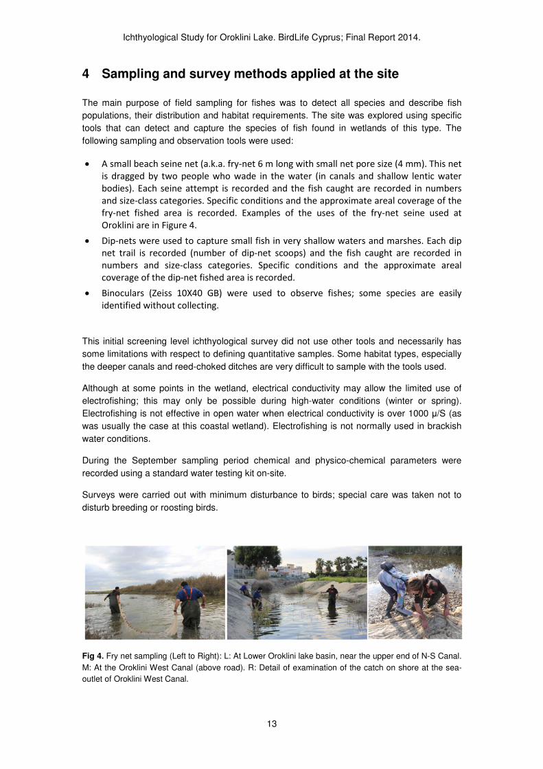
4 Sampling and survey methods applied at the site
The main purpose of field sampling for fishes was to detect all species and describe fish
populations, their distribution and habitat requirements. The site was explored using specific
tools that can detect and capture the species of fish found in wetlands of this type. The
following sampling and observation tools were used:
• A small beach seine net (a.k.a. fry-net 6 m long with small net pore size (4 mm). This net
is dragged by two people who wade in the water (in canals and shallow lentic water
bodies). Each seine attempt is recorded and the fish caught are recorded in numbers
and size-class categories. Specific conditions and the approximate areal coverage of the
fry-net fished area is recorded. Examples of the uses of the fry-net seine used at
Oroklini are in Figure 4.
• Dip-nets were used to capture small fish in very shallow waters and marshes. Each dip
net trail is recorded (number of dip-net scoops) and the fish caught are recorded in
numbers and size-class categories. Specific conditions and the approximate areal
coverage of the dip-net fished area is recorded.
• Binoculars (Zeiss 10X40 GB) were used to observe fishes; some species are easily
identified without collecting.
This initial screening level ichthyological survey did not use other tools and necessarily has
some limitations with respect to defining quantitative samples. Some habitat types, especially
the deeper canals and reed-choked ditches are very difficult to sample with the tools used.
Although at some points in the wetland, electrical conductivity may allow the limited use of
electrofishing; this may only be possible during high-water conditions (winter or spring).
Electrofishing is not effective in open water when electrical conductivity is over 1000 µ/S (as
was usually the case at this coastal wetland). Electrofishing is not normally used in brackish
water conditions.
During the September sampling period chemical and physico-chemical parameters were
recorded using a standard water testing kit on-site.
Surveys were carried out with minimum disturbance to birds; special care was taken not to
disturb breeding or roosting birds.
Fig 4. Fry net sampling (Left to Right): L: At Lower Oroklini lake basin, near the upper end of N-S Canal.
M: At the Oroklini West Canal (above road). R: Detail of examination of the catch on shore at the sea-
outlet of Oroklini West Canal.
Ichthyological Study for Oroklini Lake. BirdLife Cyprus; Final Report 2014.
14
5 Survey work results
5.1 Past work
The author (within HCMR / WDD projects) has surveyed fishes at Oroklini once before. The
lower part of the area was sampled with fry nets with Mr. Haris Nikolaou of the Department of
Forests (19/04/2012). The data from these samples are published in summary in Zogaris et
al. (2012) and are provided in detail in Appendix 1. This is the only previous work available on
the fishes of the lake and it included only a single visit to the lake in spring 2012.
5.2 Current work
For this project, the site was surveyed during spring (March 2013), during the summer-period
(September 2013) and winter period (January 2014). The March visit, took place before
official commencement of the project. The project was awarded in August 2013. In
September, a research survey took place during a three day period and this was repeated in
early January 2014. From the above work the following comments on the ichthyofauna and
the area’s habitat potential for fishes is possible.
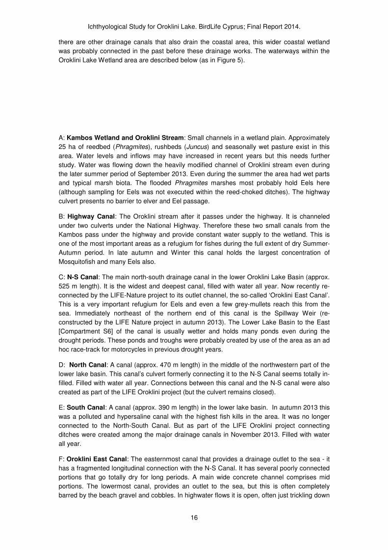
5.3 Aquatic and semi-aquatic habitats for fishes at Oroklini
Until recently, many visitors to the wetland considered only the Oroklini Upper Lake Basin as
“Oroklini Lake” proper (see fig. 2 thatched in blue). Obviously Oroklini is a much larger
wetland site and it is hydrologically connected with the upland stream catchment and the sea.
And although the wetland has suffered extensive fragmentation it does maintain these
longitudinal connections, enabling the movement of migratory fishes to some extent. A
thorough description of this wetland therefore must include all potential habitat areas that are
utilized by fish populations.
From our on-site inspection of the entire area in both the wet and dry seasons we provide an
initial delineation of the main lentic body and associated fringing marshlands from an
ichthyological and hydrobiological point of view (see Figure 5 blue outline). Figure 4 gives a
conservative approximation of the contiguous wetland area defining the site (Oroklini Lake
Wetland). This approximation focuses on the connectivity among wetland units and defines
the major waterways (canals and streams) that provide movement and refugia for aquatic
organisms during drought periods. For fishes an important aspect of the habitat are the
canals which are artificial waterways. The following major waterways are named here for
descriptive purposes (see fig 2 in yellow):

Ichthyological Study for Oroklini Lake. BirdLife Cyprus; Final Report 2014.
15
Fig. 5. Oroklini Lake Wetland (delineated in blue). This delineation is based on wetland vegetation and
habitat attributes in 2013 (blue coloured [2]). The “Upper Lake Basin” is thatched blue-coloured [1]).
Important waterways are provisionally named here for descriptive-interpretive purposes (in yellow); A:
Oroklini Stream, B: Highway Canal, C: N-S Canal, D: North Canal, E: South Canal, F: Oroklini East
Canal, G: Oroklini West Canal. (Google Earth Image during a recent high-water period, May 21st 2013)
Within an ichthyological perspective, the following main “water features” are arbitrarily
delineated and described as they were encountered during dry and wet periods during the
study. The Oroklini Lake Wetland system is rather simple and defined by the topography of a
very small coastal river basin (the Oroklini stream) and its heavily modified (largely drained)
coastal wetland area. The lower coastal part of the basin, is a topographically lower elevation
former lagoon basin behind a wide shingle beach barrier. Today the lagoonal basin and
surrounding marshes is drained by two canals which we arbitrarily labelled here as Oroklini
West Canal and Oroklini East Canal. Along the coast towards Larnaka and also towards Pyla
Ichthyological Study for Oroklini Lake. BirdLife Cyprus; Final Report 2014.
16
there are other drainage canals that also drain the coastal area, this wider coastal wetland
was probably connected in the past before these drainage works. The waterways within the
Oroklini Lake Wetland area are described below (as in Figure 5).
A: Kambos Wetland and Oroklini Stream: Small channels in a wetland plain. Approximately
25 ha of reedbed (Phragmites), rushbeds (Juncus) and seasonally wet pasture exist in this
area. Water levels and inflows may have increased in recent years but this needs further
study. Water was flowing down the heavily modified channel of Oroklini stream even during
the later summer period of September 2013. Even during the summer the area had wet parts
and typical marsh biota. The flooded Phragmites marshes most probably hold Eels here
(although sampling for Eels was not executed within the reed-choked ditches). The highway
culvert presents no barrier to elver and Eel passage.
B: Highway Canal: The Oroklini stream after it passes under the highway. It is channeled
under two culverts under the National Highway. Therefore these two small canals from the
Kambos pass under the highway and provide constant water supply to the wetland. This is
one of the most important areas as a refugium for fishes during the full extent of dry Summer-
Autumn period. In late autumn and Winter this canal holds the largest concentration of
Mosquitofish and many Eels also.
C: N-S Canal: The main north-south drainage canal in the lower Oroklini Lake Basin (approx.
525 m length). It is the widest and deepest canal, filled with water all year. Now recently re-
connected by the LIFE-Nature project to its outlet channel, the so-called ‘Oroklini East Canal’.
This is a very important refugium for Eels and even a few grey-mullets reach this from the
sea. Immediately northeast of the northern end of this canal is the Spillway Weir (re-
constructed by the LIFE Nature project in autumn 2013). The Lower Lake Basin to the East
[Compartment S6] of the canal is usually wetter and holds many ponds even during the
drought periods. These ponds and troughs were probably created by use of the area as an ad
hoc race-track for motorcycles in previous drought years.
D: North Canal: A canal (approx. 470 m length) in the middle of the northwestern part of the
lower lake basin. This canal’s culvert formerly connecting it to the N-S Canal seems totally in-
filled. Filled with water all year. Connections between this canal and the N-S canal were also
created as part of the LIFE Oroklini project (but the culvert remains closed).
E: South Canal: A canal (approx. 390 m length) in the lower lake basin. In autumn 2013 this
was a polluted and hypersaline canal with the highest fish kills in the area. It was no longer
connected to the North-South Canal. But as part of the LIFE Oroklini project connecting
ditches were created among the major drainage canals in November 2013. Filled with water
all year.
F: Oroklini East Canal: The easternmost canal that provides a drainage outlet to the sea - it
has a fragmented longitudinal connection with the N-S Canal. It has several poorly connected
portions that go totally dry for long periods. A main wide concrete channel comprises mid
portions. The lowermost canal, provides an outlet to the sea, but this is often completely
barred by the beach gravel and cobbles. In highwater flows it is open, often just trickling down

Ichthyological Study for Oroklini Lake. BirdLife Cyprus; Final Report 2014.
17
over the beach cobbles to the sea. In winter 2014 large boulders were placed at the outlet
blocking it completely. Oroklini East Canal at its lower portion, near the sea is a very narrow
ditch but it holds water all year round (including small numbers of fish). Movement of Eels up
this system is hindered at several locations (barriers) unlike the Oroklini West Canal which
has an open connection with the sea and deep-water refugia.
G: Oroklini West Canal: The most important canal connecting the Orokini lake basin with the
sea and providing seasonal access to fish movement. The canal can be described in three
parts: a narrow deep ditch in the upland inland part (upper ditch), a wide concrete canal
through the conurbation near the sea, and the artificially widened canal-mouth channel near
the sea. At the canal-mouth near the sea, the deep coastal canal is fringed with Phragmites
reed and has constant contact with the sea. It is filled with water year round. The lower part of
the canal is an important area for fish (Eels, Grey-mullets and other fishes, even during
extreme droughts). When the Oroklini Lake lower basin is flooded water enters the upper
ditch and may remain there during summer. The upper ditch had water during September
2013. The concrete mid section of the channel partially dries every summer.

Ichthyological Study for Oroklini Lake. BirdLife Cyprus; Final Report 2014.
18
5.4 Investigating reference conditions at Oroklini (Ichthyological attributes)
The concept of reference conditions is pivotal when utilizing fishes for bioassessment (as per
the EU Water Framework Directive) and it directly provides baselines for conservation and
restoration planning also. Reference conditions may be important when assessing Favourable
Conservation Status (FCS)1 of certain habitats. It is important that a working hypothesis on
type-specific reference conditions be provided or at least attempted in order to assess current
understanding and future research needs for conservation management at Oroklini Lake
Wetland.
As expressed above, it is our opinion that in former times Oroklini Lake Wetland functioned as
a coastal lagoon limnosystem with natural drainage connections to the sea (at least during
winter-spring flooding periods). This is the first time the “lake” has been called a ‘coastal
lagoon’ feature and more research is necessary to define what can be interpreted with
respect to environmental change from its local history.
In the past this limnosystem must have had large populations of European Eel (Anguilla
anguilla) and these penetrated into the headwater streamlets to find locations to survive the
long drought. Interviews throughout Cyprus confirm that Eels were widespread and often
abundant in coastal wetlands (Zogaris et al. 2012). Depending on the conditions of the
drainage outlets to the sea this lake-like lagoon must have had grey-mullets entering in large
numbers – at least three species (one Mugil sp., and at least two Liza spp.).Depending on the
extent of dry-season aquatic refugia these species spent various amounts of time feeding and
growing rapidly in warm shallow brackish waters; they migrated to sea to spawn.
The lagoon system also probably had a thriving population of Aphanius fasciatus (now
restricted only to two large lagoonal wetlands at Ammochostos and Akrotiri). This species is
partial to lagoonal and coastal wetland conditions such as hypersaline and open salina-like
lagoons of many forms. If we are to assume that the populations of this species are native on
Cyprus, this species must have been once widespread along the wetlands of Cyprus’s south
coast – it can use shallow coastal marine waters to irregularly disperse for short distances
among small coastal wetland sites (but it does not normally survive in marine conditions; it is
a poor disperser and does not undergo migrations). The main reason we purport that this
currently rare species may have been once widespread is the fact that small coastal wetlands
with a connection to the sea were much more abundant and larger in areal extent than today
providing optimal habitats at least 200 years ago (see Appendix 4). After systematic draining
of coastal wetlands, the widespread DDT campaign (1946-1978), and the introduction of the
Mosquitofish, Aphanius has probably declined on Cyprus. Aphanius and Gambusia compete,
and Gambusia have been shown to negatively affect Aphanius populations in other
Mediterranean countries. Today Aphanius survives only in the two largest coastal wetland
1 FCS is defined in Article 1(e) of the Habitats Directive as when a habitat can be considered
stable or increasing, the habitat is functioning as it should and will do so for the foreseeable future and, the species that are intrinsic to the habitat are also considered at favourable status.
Ichthyological Study for Oroklini Lake. BirdLife Cyprus; Final Report 2014.
19
sites where the extensive habitat conditions provide refuges (Pediaios Delta at Ammochostos
and Akrotiri Lagoon-Kouris Delta System).
We have no evidence to prove that other species entered the Oroklini Lake Wetland from the
sea but it is probable that at least three other marine transient fishes may have regularly
entered and utilized the lagoon wetlands conditions (as they do in other very small stream
and canal-mouths that enter the sea (see Zogaris et al. 2012)). Based on all available
evidence, we therefore hypothesize that fish populations were an important attribute of the
natural conditions in the lagoonal limnosystem of Oroklini Lake Wetland 100 years ago.
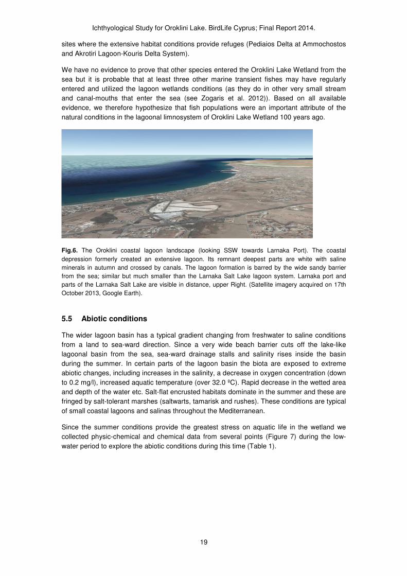
Fig.6. The Oroklini coastal lagoon landscape (looking SSW towards Larnaka Port). The coastal
depression formerly created an extensive lagoon. Its remnant deepest parts are white with saline
minerals in autumn and crossed by canals. The lagoon formation is barred by the wide sandy barrier
from the sea; similar but much smaller than the Larnaka Salt Lake lagoon system. Larnaka port and
parts of the Larnaka Salt Lake are visible in distance, upper Right. (Satellite imagery acquired on 17th
October 2013, Google Earth).
5.5 Abiotic conditions
The wider lagoon basin has a typical gradient changing from freshwater to saline conditions
from a land to sea-ward direction. Since a very wide beach barrier cuts off the lake-like
lagoonal basin from the sea, sea-ward drainage stalls and salinity rises inside the basin
during the summer. In certain parts of the lagoon basin the biota are exposed to extreme
abiotic changes, including increases in the salinity, a decrease in oxygen concentration (down
to 0.2 mg/l), increased aquatic temperature (over 32.0 ºC). Rapid decrease in the wetted area
and depth of the water etc. Salt-flat encrusted habitats dominate in the summer and these are
fringed by salt-tolerant marshes (saltwarts, tamarisk and rushes). These conditions are typical
of small coastal lagoons and salinas throughout the Mediterranean.
Since the summer conditions provide the greatest stress on aquatic life in the wetland we
collected physic-chemical and chemical data from several points (Figure 7) during the low-
water period to explore the abiotic conditions during this time (Table 1).

Ichthyological Study for Oroklini Lake. BirdLife Cyprus; Final Report 2014.
20
Fig. 7. Image of Oroklini with specific sites where water samples were taken in September 2013. Site
names are provisionally given for mnemonic assistance of the reader (as in previous sampling work): 1:
‘Highway’; 2: ‘South Canal’; 3: ‘North Canal’; 4: West Canal; 5: West Canal Inland; 6: N-S Canal; 7: East
Canal. (Image from Google Earth 17th
November 2013).
Table 1. Physico-chemical and chemical parameters recorded at seven sites at Oroklini Lake wetland
during the peak of the drought period in 2013.
The physic-chemical measurements in early September 2013 show the following:
• Water temperature was very high (28 to 32) and did not vary much among sites.
• Electrical conductivity was extremely high at certain stagnant waters such as the South
Canal (record: 71,6), North Canal and N-S Canal. All these sites are in deep-water
drainage canals within the center of the Oroklini lagoonal basin.
Ichthyological Study for Oroklini Lake. BirdLife Cyprus; Final Report 2014.
21
• Salinity was also highest in the three drainage canals within the center of the lagoon
basin reaching up to 54 in the N-S Canal, hypersaline conditions.
• Turbidity and pH are as would be expected.
• Oxygen concentration was extremely low in the North and South Canals and in the Inland
west canal were stagnant fragmented waters existed.
• Nitrates, Ammonium and phosphates were very high in the most polluted isolated North
canal. Phosphates were high at West Canal also.
5.6 Results of the sampling campaign
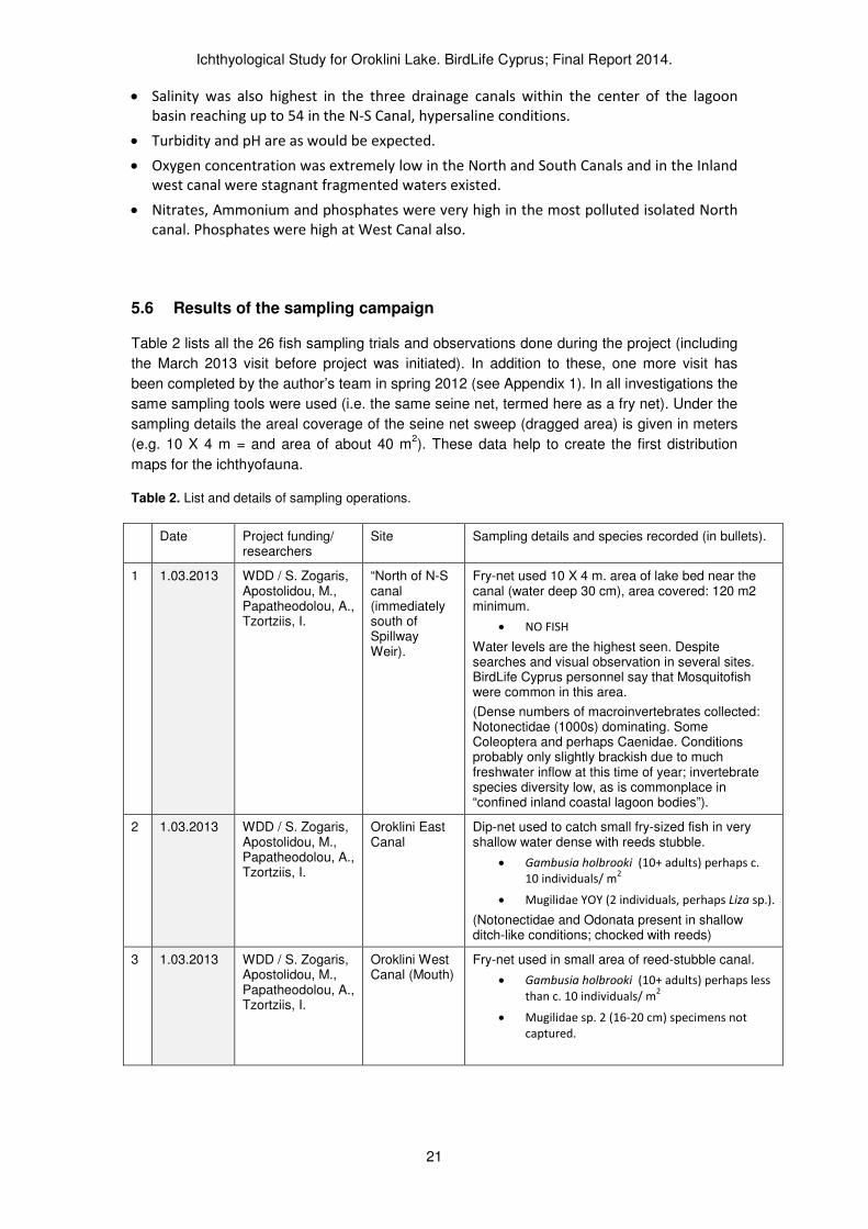
Table 2 lists all the 26 fish sampling trials and observations done during the project (including
the March 2013 visit before project was initiated). In addition to these, one more visit has
been completed by the author’s team in spring 2012 (see Appendix 1). In all investigations the
same sampling tools were used (i.e. the same seine net, termed here as a fry net). Under the
sampling details the areal coverage of the seine net sweep (dragged area) is given in meters
(e.g. 10 X 4 m = and area of about 40 m2). These data help to create the first distribution
maps for the ichthyofauna.
Table 2. List and details of sampling operations.
Date Project funding/ researchers
Site Sampling details and species recorded (in bullets).
1 1.03.2013 WDD / S. Zogaris, Apostolidou, M., Papatheodolou, A., Tzortziis, I.
“North of N-S canal (immediately south of Spillway Weir).
Fry-net used 10 X 4 m. area of lake bed near the canal (water deep 30 cm), area covered: 120 m2 minimum.
• NO FISH
Water levels are the highest seen. Despite searches and visual observation in several sites. BirdLife Cyprus personnel say that Mosquitofish were common in this area.
(Dense numbers of macroinvertebrates collected: Notonectidae (1000s) dominating. Some Coleoptera and perhaps Caenidae. Conditions probably only slightly brackish due to much freshwater inflow at this time of year; invertebrate species diversity low, as is commonplace in “confined inland coastal lagoon bodies”).
2 1.03.2013 WDD / S. Zogaris, Apostolidou, M., Papatheodolou, A., Tzortziis, I.
Oroklini East Canal
Dip-net used to catch small fry-sized fish in very shallow water dense with reeds stubble.
• Gambusia holbrooki (10+ adults) perhaps c.
10 individuals/ m2
• Mugilidae YOY (2 individuals, perhaps Liza sp.).
(Notonectidae and Odonata present in shallow ditch-like conditions; chocked with reeds)
3 1.03.2013 WDD / S. Zogaris, Apostolidou, M., Papatheodolou, A., Tzortziis, I.
Oroklini West Canal (Mouth)
Fry-net used in small area of reed-stubble canal.
• Gambusia holbrooki (10+ adults) perhaps less
than c. 10 individuals/ m2
• Mugilidae sp. 2 (16-20 cm) specimens not
captured.

Ichthyological Study for Oroklini Lake. BirdLife Cyprus; Final Report 2014.
22
Date Project funding/ researchers
Site Sampling details and species recorded (in bullets).
4 1.03.2013 WDD / S. Zogaris, Apostolidou, M., Papatheodolou, A., Tzortziis, I.
Oroklini West Canal (above road)
Fry-net used in small area of cement-bottom canal (water deep 70 cm).
• Gambusia holbrooki (50+)
• Mugilidae sp. 2 (16-20 cm) specimens not
captured.
• Mugilidae sp. 2 (21-25 cm) specimens not
captured.
5 5.09.2013 BirdLife Cyprus; S. Zogaris, Apostolidou, M., Papatheodolou, A., Tzortziis, I.
Lower N-S Canal ( southern end)
Dip net and visual observations; most fish dead
• Anguilla anguilla 20+ (<40cm); 2 (>40 cm) (all
Dead)
• Mugil cephalus 1 (23 cm). (Dead)
Some movements in water point to some fish still alive in the canal, identification not possible. Water stagnant, dark.
No Gambusia apparent.
Perhaps about 200 dead Eels counted floating in all Canal (525 m. long); the numbers dead were probably much higher.
6 5.09.2013 BirdLife Cyprus; S. Zogaris, Apostolidou, M., Papatheodolou, A., Tzortziis, I.
Upper N-S Canal (northern end)
Dip net and visual observations; most fish dead
• Anguilla anguilla 30+ (Dead); perhaps about
200 dead Eels in upper stretch of the N-S
Canal.
• Mugil cephalus 1 (23 cm). (Dead)
No Gambusia apparent (if small populations survive they are in very small numbers – some movements seen but not attributed specifically to Gambusia)
7 5.09.2013 BirdLife Cyprus; S. Zogaris, Apostolidou, M., Papatheodolou, A., Tzortziis, I.
South Canal (A.K.A. “Dirty Canal).
Dip net, fry net locally; and visual observations; all fish dead
• Anguilla anguilla estimated at about 500 Eels
apparent. The total number is obviously much
larger.
• Gambusia holbrooki 15 (all < 7 cm); very low
population density (counted along 380 m. of
canal’s stretch).
Old culvert connecting the canal to N-S Canal completely plugged by sediments.
Canal water “colored” pink most probably by a bloom of Halobacterium salinarum2. This Canal had most dead Eels as compared to N-S Canal and North Canal; conditions were most stagnant and water’s seemed lifeless.
2Although the presence of Halobacterium salinarum has not been confirmed at Oroklini this or
a related species and the “pink water” feature is typical of saline lagoons environments. It is an extremely halophilic marine Gram-negative obligate aerobic archaeon. Despite its name, this microorganism is not a bacterium, but rather a member of the domain Archaea.

Ichthyological Study for Oroklini Lake. BirdLife Cyprus; Final Report 2014.
23
Date Project funding/ researchers
Site Sampling details and species recorded (in bullets).
8 5.09.2013 BirdLife Cyprus; S. Zogaris, Apostolidou, M., Papatheodolou, A., Tzortziis, I.
North Canal (A.K.A. “Clean Canal).
Dip net, fry net locally; and visual observations; some Eels dead.
• Anguilla anguilla estimated at about 100.Only
dead Eels apparent. The total number is
obviously much larger.
• Gambusia holbrooki 30 (all < 7 cm); low
density.
Conditions not as stagnant or polluted as South Canal. Swallows/Martins were foraging for Diptera above this canal, whereas the South Canal had no insect life.
9 5.09.2013 BirdLife Cyprus; S. Zogaris, Apostolidou, M., Papatheodolou, A., Tzortziis, I.
Highway Canal
(At road crossing)
Dip net, fry net locally; and visual observations; reedbed not sampled (conditions very dense reeds).
• Gambusia holbrooki 100+ (all < 7 cm);
medium density; not over-abundant.
Two size classes (equivalent to age-classes of Gambusia apparent). This points to survival and growth of Gambusia throughout this area (a refugium). Insect life very limited and not diverse. Water still; but water with disagreeable odor entering from culvert (Oroklini Stream).
10
5.09.2013 BirdLife Cyprus; S. Zogaris, Apostolidou, M., Papatheodolou, A., Tzortziis, I.
East Segment of Lower Lake Basin; in small isolated pools
Visual observations; all fish dead.
• Anguilla anguilla estimated at about 10 Eels
apparent. Small-sized <35 cm.
11
5.09.2013 BirdLife Cyprus; S. Zogaris, Apostolidou, M., Papatheodolou, A., Tzortziis, I.
East Canal (above road)
Dip net, fry net locally; and visual observations;
• Gambusia holbrooki 10 (all < 7 cm); Low
density.
12
5.09.2013 BirdLife Cyprus; S. Zogaris, Apostolidou, M., Papatheodolou, A., Tzortziis, I.
East Canal (near sea)
Dip net, fry net locally; and visual observations;
• Gambusia holbrooki 25+ (all < 7 cm); Low
density.
Width of ditch only 30 cm. and depth about 10 cm (some spots much deeper). No flow to sea, blocked by boulders.
13
6.09.2013 BirdLife Cyprus; S. Zogaris, A., Tzortziis, I.
East Canal (upstream of bridge)
Visual observations;
• Gambusia holbrooki 5+ (all < 7 cm); Low
density.
Very few insects apparent in ditch-like environment. Water eutrophic (thick film of green algae). Conditions nearly impossible to sample using nets due to thick Phragmites stalks.
14
7.09.2013 BirdLife Cyprus; S. Zogaris, E. Tzirkalli
Upper Lake Basin Weir
Visual observations (all fish dead)
• Anguilla anguilla: 450. (dead; a subsample of
200 measured to cm TL)
• Mugilidae sp. 1, approx. 20 cm. (dead; nearly
totally decomposed)

Ichthyological Study for Oroklini Lake. BirdLife Cyprus; Final Report 2014.
24
Date Project funding/ researchers
Site Sampling details and species recorded (in bullets).
15
7.09.2013 BirdLife Cyprus; S. Zogaris, E. Tzirkalli
Incoming Oroklini stream, u/s of culvert; Kambos Wetland
Visual observations/ inspection conditions not possible for sampling (low water); The channel of Oroklini stream was only 70 cm wide and very shallow; water was polluted (disagreeable odor).
• NO FISH
Although water very shallow (<10 cm) and looking polluted, three species of Odonata spotted.
16
7.09.2013 BirdLife Cyprus; S. Zogaris, E. Tzirkalli
West Canal above road
Visual observations
• Gambusia holbrooki about five fishes per m2
(moderate density)
• Mugilidae sp. 10 + (specimens larger than 15
cm)
17
7.09.2013 BirdLife Cyprus; S. Zogaris, E. Tzirkalli
West Canal
(canal mouth, below road)
Visual observations
• Gambusia holbrooki about three fishes per
m2 (moderate density)
• Mugilidae sp. 15 + (specimens larger than 20
cm)
18
7.09.2013 BirdLife Cyprus; S. Zogaris, E. Tzirkalli
West Inland
(Near point of sharp turn in ditch). This ditch connects to the Oroklini West Canals downstream.
Visual observations (sampling not possible)
• Anguilla anguilla: 1 c. 25 cm observed.
No other fish present.
Clear water and deep (at least 30 cm average), at places very narrow deep ditch-like conditions. Notonectidae in large numbers and three spp. of Odonata. Water very still.
19
10.01.2014 BirdLife Cyprus; S. Zogaris, Apostolidou, M.,
Highway canal at road crossing.
Fry-net beach seine.
• Gambusia holbrooki ; only 5 specimens caught
after 50 m2 sampled. (low density)
Water flow as in March 2013; disagreeable odor. Area seemingly rich in Notonectidae but other zoobenthic organizims scant (singles of the following collected in seine: Coleoptera, Chironomidae, Odonata).
20
10.01.2014 BirdLife Cyprus; S. Zogaris, Apostolidou, M.,
West Canal
(canal mouth, below road)
Fry-net beach seine.
• Gambusia holbrooki ; only 7 specimens caught
after 18 m2 sampled. (low density)
Canal has been dredged and is impossible to sample with seine net (now steeply sloping).
South wind forced sea water into the canal.
21
10.01.2014 BirdLife Cyprus; S. Zogaris, Apostolidou, M.,
West Canal
(canal upstream of road – to first culvert)
Fry-net beach seine.
• Gambusia holbrooki about three fishes per
m2 (moderate density)
• Anguilla anguilla: 3 indvls. (16 cm, 17 cm, 20
cm)
• Mugil cephalus: 25 indvls, young-of-the-year
(<3 cm)
• Liza sp (Mugilidae sp). 1 + (specimens larger
than 18 cm)
Many chironomids in water; Notonectidae in moderate numbers.
Ichthyological Study for Oroklini Lake. BirdLife Cyprus; Final Report 2014.
25
Date Project funding/ researchers
Site Sampling details and species recorded (in bullets).
22
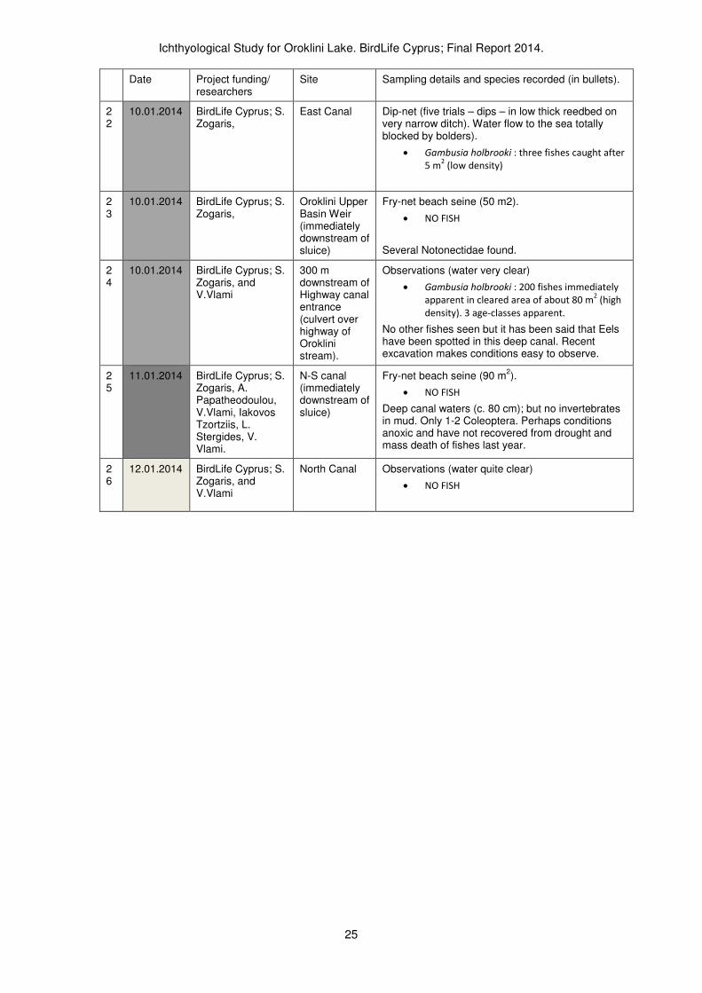
10.01.2014 BirdLife Cyprus; S. Zogaris,
East Canal Dip-net (five trials – dips – in low thick reedbed on very narrow ditch). Water flow to the sea totally blocked by bolders).
• Gambusia holbrooki : three fishes caught after
5 m2 (low density)
23
10.01.2014 BirdLife Cyprus; S. Zogaris,
Oroklini Upper Basin Weir (immediately downstream of sluice)
Fry-net beach seine (50 m2).
• NO FISH
Several Notonectidae found.
24
10.01.2014 BirdLife Cyprus; S. Zogaris, and V.Vlami
300 m downstream of Highway canal entrance (culvert over highway of Oroklini stream).
Observations (water very clear)
• Gambusia holbrooki : 200 fishes immediately
apparent in cleared area of about 80 m2 (high
density). 3 age-classes apparent.
No other fishes seen but it has been said that Eels have been spotted in this deep canal. Recent excavation makes conditions easy to observe.
25
11.01.2014 BirdLife Cyprus; S. Zogaris, A. Papatheodoulou, V.Vlami, Iakovos Tzortziis, L. Stergides, V. Vlami.
N-S canal (immediately downstream of sluice)
Fry-net beach seine (90 m2).
• NO FISH
Deep canal waters (c. 80 cm); but no invertebrates in mud. Only 1-2 Coleoptera. Perhaps conditions anoxic and have not recovered from drought and mass death of fishes last year.
26
12.01.2014 BirdLife Cyprus; S. Zogaris, and V.Vlami
North Canal Observations (water quite clear)
• NO FISH
Ichthyological Study for Oroklini Lake. BirdLife Cyprus; Final Report 2014.
26
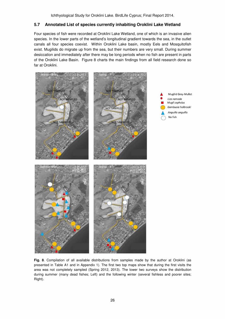
5.7 Annotated List of species currently inhabiting Oroklini Lake Wetland
Four species of fish were recorded at Oroklini Lake Wetland, one of which is an invasive alien
species. In the lower parts of the wetland’s longitudinal gradient towards the sea, in the outlet
canals all four species coexist. Within Oroklini Lake basin, mostly Eels and Mosquitofish
exist. Mugilids do migrate up from the sea, but their numbers are very small. During summer
desiccation and immediately after there may be long periods when no fish are present in parts
of the Oroklini Lake Basin. Figure 8 charts the main findings from all field research done so
far at Oroklini.
Fig. 8. Compilation of all available distributions from samples made by the author at Oroklini (as
presented in Table A1 and in Appendix 1). The first two top maps show that during the first visits the
area was not completely sampled (Spring 2012, 2013). The lower two surveys show the distribution
during summer (many dead fishes; Left) and the following winter (several fishless and poorer sites;
Right).

Ichthyological Study for Oroklini Lake. BirdLife Cyprus; Final Report 2014.
27
Fig. 9. Scenes and species from Oroklini Lake Wetland. A. Sampling at N-S Canal with Fry-net; after
the mass fish kills of Summer-Autumn 2013; this winter sampling yielded no fish and remarkably few
invertebrates (01/2014). B. Oroklini West Canal above the bridge: a very important refuge for Eels that
eventually find their way upstream to Oroklini (09/2013). C. Oroklini West Canal below the bridge;
deepened artificially this site is very important for marine fishes and Eels that enter inland waters
(09/2013). D. West Canal Inland; a deep ditch leads all the way to the lower basin of Lake Oroklini
Wetland (09/2013). E. West Canal Inland; agricultural landscape immediately west of the Lake proper;
the small ditch is a migratory “life-line” for Eels migrating up to the lake. F. Culvert-bridge under the
National Highway linking Oroklini Stream to the upper Oroklini Lake Basin; this is not a barrier to Eels
(03/2013); G. Oroklini East Canal, a very small ditch in full flood and flowing to sea under a “culvert-
pipe” on the beach (03/2013); H. Oroklini East Canal “culvert-pipe” on the beach on 03/2013, it was
totally blocked by boulders with no flow in January 2014. I: Mosquitofish, Gambusia holbrooki
(Κουνοποφάγος, Κουνουπιέρης, Κουνοπόψαρο) J. The Kambos Wetland above the National Highway,
although not part of the protected area (but included in the IBA) it is a wetland with drainage canals and
Oroklini stream that feeds Oroklini Lake, immediately downstream (09/2013). Κ: Young Striped Mullet
Μugil cephalus (Κέφαλος). L. European Eel Anguilla anguilla (Χέλι).
Ichthyological Study for Oroklini Lake. BirdLife Cyprus; Final Report 2014.
28
5.7.1 European Eel (Angilla anguilla)
Oroklini Lake Wetland is one of the most important known sites for European Eels on Cyprus
(see Appendix 3). Other river basins such as the Pediaios, the Diarizos, and the Chrysochou
are probably equally important in terms of the populations of Eels they sustain but research is
incomplete to assess this (Zogaris et al. 2012). We have concrete evidence that hundreds of
Eels enter and live in Oroklini. And this alone is very important as a conservation issue since
the species is globally threatened; designated as Critically Endangered in a recent IUCN
assessment (Jacoby, D. & Gollock, M. 2014).
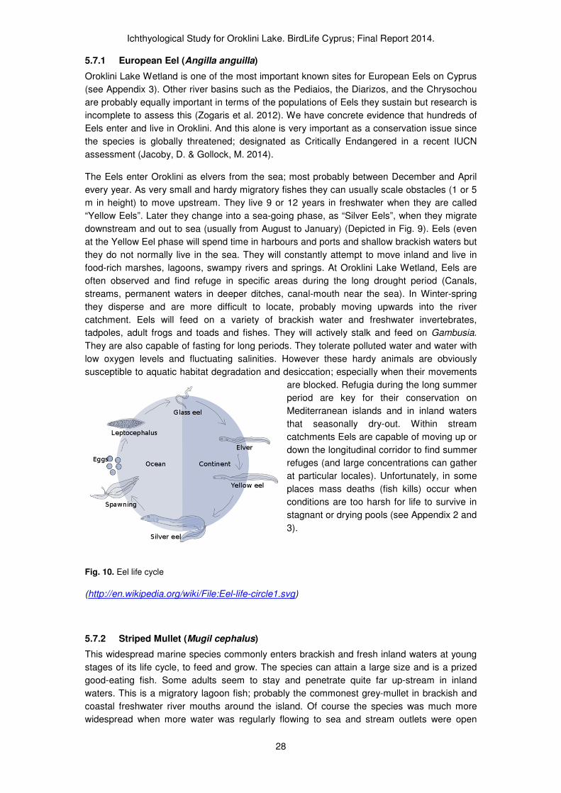
The Eels enter Oroklini as elvers from the sea; most probably between December and April
every year. As very small and hardy migratory fishes they can usually scale obstacles (1 or 5
m in height) to move upstream. They live 9 or 12 years in freshwater when they are called
“Yellow Eels”. Later they change into a sea-going phase, as “Silver Eels”, when they migrate
downstream and out to sea (usually from August to January) (Depicted in Fig. 9). Eels (even
at the Yellow Eel phase will spend time in harbours and ports and shallow brackish waters but
they do not normally live in the sea. They will constantly attempt to move inland and live in
food-rich marshes, lagoons, swampy rivers and springs. At Oroklini Lake Wetland, Eels are
often observed and find refuge in specific areas during the long drought period (Canals,
streams, permanent waters in deeper ditches, canal-mouth near the sea). In Winter-spring
they disperse and are more difficult to locate, probably moving upwards into the river
catchment. Eels will feed on a variety of brackish water and freshwater invertebrates,
tadpoles, adult frogs and toads and fishes. They will actively stalk and feed on Gambusia.
They are also capable of fasting for long periods. They tolerate polluted water and water with
low oxygen levels and fluctuating salinities. However these hardy animals are obviously
susceptible to aquatic habitat degradation and desiccation; especially when their movements
are blocked. Refugia during the long summer
period are key for their conservation on
Mediterranean islands and in inland waters
that seasonally dry-out. Within stream
catchments Eels are capable of moving up or
down the longitudinal corridor to find summer
refuges (and large concentrations can gather
at particular locales). Unfortunately, in some
places mass deaths (fish kills) occur when
conditions are too harsh for life to survive in
stagnant or drying pools (see Appendix 2 and
3).
Fig. 10. Eel life cycle
(http://en.wikipedia.org/wiki/File:Eel-life-circle1.svg)
5.7.2 Striped Mullet (Mugil cephalus)
This widespread marine species commonly enters brackish and fresh inland waters at young
stages of its life cycle, to feed and grow. The species can attain a large size and is a prized
good-eating fish. Some adults seem to stay and penetrate quite far up-stream in inland
waters. This is a migratory lagoon fish; probably the commonest grey-mullet in brackish and
coastal freshwater river mouths around the island. Of course the species was much more
widespread when more water was regularly flowing to sea and stream outlets were open
Ichthyological Study for Oroklini Lake. BirdLife Cyprus; Final Report 2014.
29
(before widespread dam building on Cyprus). Large numbers still enter some rivers and
wetlands locally, but they are usually blocked by anthropogenic barriers. Mass deaths of the
fish (and related Mugilids) have been observed at Ammochostos lagoons near the Pediaios
river-mouth (Pediaios Delta in 2012).
This species seem to be the commonest grey-mullet species at Oroklini, at least as our
limited sampling records show. Ten young-of-year individuals were collected Oroklini West
Canal near river-mouth on 19.04.2012. In September 2013 at least three larger individuals (20
cm) were identified in the North-South Canal (they had died in the related fish kill). Large
unidentified Mugilids that may belong to this species also penetrate up into the Oroklini West
Canal for a few hundred meters beyond the coast road.
5.7.3 Thinlip Mullet (Liza ramada)
This is a common marine species that frequently enters freshwaters but spawns at sea. It is
probably a common and regular visitor at Oroklini in the two out-going canals (Oroklini East
Canal, Oroklini West Canal), although this is not confirmed by monitoring. Only 10 young-of-
year individuals were collected at Oroklini East Canal near the canal’s mouth on 19.04.2012.
This species commonly enters freshwaters, so it may also penetrate much more inland and
should be found at Oroklini West Canal as well. Several specimens of grey-mullets (Mugilids,
i.e. in the family Mugilidae) at Oroklini West Canal could not be captured but fleeting glimpses
with binoculars point that they were probably Liza sp. Identification of young Liza sp. fishes
(under 10 cm) usually requires careful inspection. In Cyprus, in one other location, one other
Liza species has been collected in inland stream-mouths, Liza aurata (Zogaris et al. 2012).
The Liza spp. just like Mugil cephalus enter freshwater to feed on algae and detritus, using
them as nursery grounds. They then may migrate out to sea to grow; all Cypriot Mugilids
reproduce at sea, not in inland waters.
5.7.4 Mosquitofish (Gambusia holbrooki)
Also known as the Eastern Mosquitofish (and closely related to the Western Mosquitofish
Gambusia affinis). Gambusia affinis and G. holbrooki were long considered subspecies of G.
affinis, and were only recently recognized as separate species; the species considered to be
introduced in the Mediterranean has been confirmed as Gambusia holbrooki . It is a
subtropical and warm temperate fish of the Southern United States, now considered one of
the most widespread invasive alien species in the world. The species is said to have been
introduced into Cyprus in the 1930s. It is very widespread in Cyprus and often spread by local
government agencies and by local inhabitants to combat mosquitos. Populations easily
establish and reproduce in the wild in many different inland water types in Cyprus.
Permanent populations exist in both Oroklini East Canal, Oroklini West Canal and Highway
Canal throughout the year. Αt Oroklini West Canal populations are quite dense in spring-
summer. The species is a live-bearing fish, spawning when waters are warm. Populations in
the Upper Lake Basin fluctuate but they are maintained at fairly high levels at the incoming
Highway Canal year-round. This canal seems to have populations throughout the year in high
densities. The fish are said to be present in the Kambos canals north of the highway as well
but they were not recorded at the stream outlet during our September visit.
Gambusia are freshwater fish but very tolerant of polluted conditions. However long-term
conditions for this hardy species are detrimental when salinities rise in the summer (as is the
case in the Lower Oroklini Lake Basin), so the species survives in very low densities in the
canals (North-South and North) and was totally absent from many water pools, ponds and
from the Lower Oroklini Lake Basin in September 2013. It is a poor disperser and does not
migrate, so populations units may remain localized (and may be extirpated when conditions

Ichthyological Study for Oroklini Lake. BirdLife Cyprus; Final Report 2014.
30
are extremely poor). At Oroklini Lake Basin, in no instance were populations so high as to be
a cause for concern, in terms of a “super-abundance” which is often observed by this species
in small shallow and warm freshwater bodies. The main limiting factor to the species’ density
is probably high summer salinity and desiccation during the summer at Oroklini Lake Wetland.

Ichthyological Study for Oroklini Lake. BirdLife Cyprus; Final Report 2014.
31
6 Synthesis and interpretation of survey work
At this point in the site’s ichthyological research we have defined within a practical inventory
framework the “type” of wetland system at Oroklini and what to expect in terms of type-
specific reference conditions (expert-based reference conditions) and a first outline of the
area’s ichthyofauna. The interpretations are preliminary at this time and further ecological
history research is required as is monitoring. Now we will discuss specific questions that are
relevant to conservation.
The following important aspects, relevant to specific conservation measures, have been
researched and are interpreted here.
6.1 Gambusia holbrooki populations and their management
There is legitimate concern about the negative effects of Gambusia as an invasive alien
species (IAS) at Oroklini Lake Wetland. One issue concerns the impact of the pressures
exerted by this fish on the native biota, the second concerns the potential for a Gambusia vs.
Aphanius biotic interaction if the latter native fish species were to be introduced.
It is not straightforward to describe a “negative impact” to the ecosystem by the introduced
Gambusia at Oroklini. In terms of the impact to the ecosystem and native biota, Gambusia
has a similar niche to Aphanius or other Cyprinodonts. Cyprinodonts (i.e. feeding on small
invertebrate animals – often near on under the surface) concentrate in coastal marshes and
are important parts of coastal wetland food webs in the Mediterranean. This niche may be
called “surface-oriented, top-feeding niche”. If we are to relate the impact utilizing the “vacant
niche” concept, one would not expect undue changes produced by the Gambusia populations
(especially since they may be kept at medium densities by high salinity and desiccation during
the summer). Gambusia are very poor dispersers, they do not migrate, so this also keeps the
population foraging affect localized (Pyke, 2005). However Gambusia will forage on native
invertebrates, sometimes removing large numbers, and this may have limnological effects. In
such a way dense populations of Gambusia may deplete zoobenthic and planktonic
invertebrate populations. Introducing Gambusia also can precipitate algal blooms when the
fish eat the zooplankton grazers, but usually large densities of the fishes are needed to
accomplish this. Mosquitofish are so called because they are thought to have a legendary
ability to control mosquitoes; some researchers doubt this ability or argue that indigenous fish
are equally or more effective. However, rigorous evidence to support these views remains
scant. In fact, by eliminating invertebrate predators and zooplankton grazers, Gambusia can,
under certain circumstances, alter planktonic conditions (eliminating zooplankton) and they
may actually encourage the proliferation of mosquito larvae (Pyke, 2008).
There are other reasons Gambusia have been accused of severe negative environmental
impact. They are very aggressive and will attack fish much larger than themselves and they
also feed on amphibian eggs and young larvae. This has led them to being nicknamed “killer
guppies” (Fish & Game New Zealand, 2005). In fact this agonistic behavior has been shown
to impact native similar-sized fishes in many parts of the world. At Oroklini only the
introduction/or re-introduction of a native inland water fish (e.g. Aphanius) will produce such a
situation of potential conflict. Today, with no native inland water fishes taking up a similar
niche the Gambusia have no competitors.
Our assessment of the situation at Oroklini is summarized here:

Ichthyological Study for Oroklini Lake. BirdLife Cyprus; Final Report 2014.
32
• Gambusia are an invasive alien species with a very similar niche that the wide-spread
Aphanius sp. normally take up in other coastal lagoons throughout the Mediterranean. It
is hypothesized that Aphanius has declined due to wetland anthropogenic degradation on
Cyprus, so this alien Gambusia species is the only similar-sized inland water resident fish
in this habitat type. In this sense the replacement of Gambusia may serve to fill a “vacant
niche” at Oroklini, thus enriching the local food web. There is no doubt many fish-eating
birds and the European Eel do feed on Gambusia.
• An over-abundance of Gambusia was not observed at Oroklini since the lake basin canals
had very high summer salinities; conditions nearly unbearable for Gambusia during low-
water summer periods. In fact, it is surprising that Gambusia were located in waters with
recorded salinities of about 45 to 50 0/00
in the canals of the Lower Oroklini Lake basin
during September 2013. These extreme values usually kill Gambusia if they persist.
• Repeated desiccation of the Oroklini Basin’s water units do precipitate a total extirpation
of Gambusia populations in some parts of the basin. So for a long time some areas of the
Lake basin have no Gambusia. The Gambusia do re-invade when water levels rise during
winter and spring. Because of this, populations do not seem high enough, or dense
enough, to create a marked dis-harmony or any noticeable negative limnological effects
on the ecosystem (e.g. depletion of zooplankton etc.). However, this aspect needs
detailed limnological monitoring to be confirmed.
Specific Proposals:
Control of Gambusia populations
Gambusia provide a source of food for some fish-eating birds and for Eels; they take up a
distinct niche in the local food web and their populations have been established for many
decades. Although a non-native alien species, and a highly invasive species, one must
consider the naturalized populations and objectively assess the potential for significan
negative impact. It is suggested here that the niche taken up by Gambusia is similar to the
niche of the native Aphanius fasciatus (however the latter is more tolerant of saline and
hypersaline conditions). At this point in our research we do not view the Gambusia
populations a particularly troubling or detrimental to the ecology of the wetland.
In particular, we have no evidence to prove that Gambusia are creating severe problems to
the biota of Lake Oroklini Wetland and do not recommend action should be taken to limit their
population or distribution at this time. We do not encourage the re-introduction or periodic
introduction of Gambusia as biological control for mosquitoes. This should not be allowed in a
protected area, alternatives approaches (native fish introduction) should be investigated in
this case as well.
However, our interpretations are preliminary and largely based on expert judgement and
experience in many similar coastal lagoon and wetland sites in the Eastern Mediterranean.
More research into the specific impacts by Gambusia on lagoon/ brackish canal biota at
Oroklini is necessary. Gambusia must be monitored within a regular sampling campaign at
least twice per year (summer, winter). They are easily monitored using a fry net and/or
observed with binoculars since they spend much time near the water’s surface and are very
easy to identify.
In the future when and if the establishment of Aphanius is promoted, action must be taken to
isolate and/or exterminate the Gambusia population since it will compete with the former.
Gambusia is already limited due to high salinity levels in the Oroklini Lake basin, populations
plummet each summer and are slowly re-established after freshwater enters basin. This

Ichthyological Study for Oroklini Lake. BirdLife Cyprus; Final Report 2014.
33
provides an opportunity to isolate certain areas from invasion by Gambusia. A plan to limit
adverse competition against the establishment of Aphanius must obviously include the in-
depth study of Gambusia ecology at Oroklini.
6.2 Aphanius fasciatus re-establishment/ introduction in Oroklini Lake Wetland
Research to better document and interpret the potential for the re-establishment/introduction
of Aphanius fasciatus was begun when the suggestion was posed during the development of
the LIFE Nature project (also mentioned in Self 2013). Generally there is an interest in
utilizing native fishes (instead of alien species) in ecological restoration (and particularly as
biological control of mosquitos); so the question of Aphanius restoration is an important one.
Fig.11. Male Aphanius fasciatus. From the highly localized Cypriot population (photograph courtesy of
Ch. Makris photographed during a fish sampling excursion within a Cyprus Water Development
Department project at Akrotiri). This species may have once existed in the wetland along Oroklini and
Larnaka it is now found only at Akrotiri and Ammochostos wetlands.
Aphanius fasciatus (Valenciennes, 1821), commonly called the Mediterranean Toothcarp
(a.k.a Mediterranean Killifish) is a small-sized omnivorous coastal wetland fish native to the
central and eastern Mediterranean. It is an attractive fish, commonly collected as an
ornamental fish by aquarium hobbyists (Figure 11). This small-sized fish is rather similar in a
general shape and size to a Gambusia. In fact, although they belong to different families, both
are distantly related; both are considered cyprinodontoids (Aphanius in the Cyprinodontidae
family, Gambusia in the Poeciliidae family). The Aphanius diet is also similar to that of
Gambusia, dominated by small invertebrates. In coastal lagoons, Aphanius fasciatus are
known to feed on isopods, branchiopods, eggs of various zooplantonic invertebrates,
mosquitoes (adults and larvae) and diatoms. An ontogenetic diet shift with an increase in
mean prey size with fish length is usually observed. Smaller fish feed on small planktonic prey
(e.g. copepods, ostracods, nauplii of Artemia), while larger fish prefer larger and more benthic
preys (e.g. amphipods). The diet of A. fasciatus usually shows a high degree of seasonal
variation, with a reduction in the feeding activity during the periods of adverse environmental
conditions (e.g. winter and autumn). Aphanius fasciatus is a well-adapted estuarine and
lagoonal fish, its feeding mode and preferences depending on prey that are available.
Aphanius fasciatus is considered to be threatened throughout its range, such that it is listed in
Appendices II (Strictly protected fauna species) and III (Protected fauna species) of the Bern
Convention (Convention on the Conservation of European Wildlife and Natural Habitats), and
in Annex II (Animal and plant species of community interest whose conservation requires the
designation of special areas of conservation) of the Habitats Directive (Council Directive

Ichthyological Study for Oroklini Lake. BirdLife Cyprus; Final Report 2014.
34
92/43/EEC). Since the species is a poor disperser (it does not migrate) it is well known that it
can easily be extirpated from a wetland site and cannot usually return (especially in small
isolated wetland sites).
We speculate that Aphanius fasciatus was extirpated from Oroklini by anthropogenic changes
in habitat and decreased connectivity among surviving habitat. Similarly, great changes took
place at Larnaka’s Salt Lake coastal wetland complex and it is not found there either. The
species survives in relatively large coastal wetland sites that can “communicate”/connect
surviving populations among coastal wetland refugia through the sea and through the
connections of remaining aquatic habitats.
It is probably, that is this widespread fish species was once widespread in many wetland son
Cyprus. During former sea-level conditions as must have been during former glacial maxima -
when global sea levels were lower than 120 m below current levels (i.e. 12 000 years ago)-
wetland features must have covered more extensive coastal areas, probably allowing the
species to be more widespread on Cyprus. Where the species exists today (at Akrotiri and
Ammochostos) its populations are quite dense and well connected by dispersal corridors (re-
flooding during high freshwater inflows) and marine connectivity along the beaches. In
seasonally changing coastal wetland connectivity with the sea or with summer refugia is vital
for long-term local survival of this species. However, it normally will not survive in the marine
environment of the open shore.
The presumed widespread geography of wetland distribution along Cyprus’s coast, leads us
to believe that the larger coastal wetlands of Cyprus had some sort of small euryhaline fish
such as the Aphanius in former times. We speculate that this species must have existed at
Oroklini as well. Extirpation from small wetlands is very frequent in inland water fishes along
the Mediterranean coasts so we can only assume that human’s triggered local extirpations of
this formerly widespread species. Extirpations must have been enhanced by rapid and
effective drainage projects in colonial times and by extensive DDT use after 1946. There is no
doubt that many native species have declined solely due to DDT poisoning (see Zogaris et al.
2012).
Unfortunately, in terms of bibliographical support there is no evidence of former populations of
the Aphanius in Cyprus with the exception of the Ammochostos and Akrotiri sites. Questions
about the long-term provenance (i.e. status as native) are not totally resolved. DNA
phylogenetics is being done on both Cypriot populations (sampled from Ammochostos and
Akrotiri) to explore all aspects of conservation genetics (ongoing work is undertaken by
researchers at the Hellenic Centre for Marine Research). Until further research proves
otherwise, we are considering the Cypriot Aphanius as part of the nominate Central and
Eastern Mediterranean species and native to the island.
Specific Proposal:
Introduction and establishment of an Aphanius fasciatus population from native
Cypriot stock to Lake Oroklini Wetland
Below we use all available knowledge and information from other re-introduction and
conservation projects in the Mediterranean to discuss the issue of Aphanius introduction.
There is no shortage of successful experience with introduction projects from other areas of
the Mediterranean (e.g. Jordan, Spain, Malta).
Introduction philosophy and feasibility
Ichthyological Study for Oroklini Lake. BirdLife Cyprus; Final Report 2014.
35
• It goes without saying that a thorough feasibility study is required; our proposals here are
initial approaches considering what limited knowledge and experience exists on this
species in Cyprus.
• The species shows a high adaptability to extreme aquatic and quality conditions. Despite
it being classified as a freshwater fish, it is capable of surviving in hypersaline
environments. The great ability of this species to adapt to salinity changes makes it
resistant to the continuous hydrologic fluctuations that the coastal wetlands of Cyprus.
We have evidence from Ammochostos to show that Aphanius did survive in warmer and
more hyper-saline conditions than marine euryhaline Mugilids. This fact may allow the
establishment of stable populations that cannot be colonized by other alien invasive
species.
• Aphanius and Gambusia may be important food resources for certain birds (see
Gambusia above); Gambusia is readily consumed by the European Eel also. So this
introduction-establishment obviously helps the ecological integrity and would enrich the
local food web of Oroklini – especially the more saline waters of the Lower Oroklini Lake
Basin.
• As a threatened native species, Aphanius fasciatus exist in only two locations in Cyprus, a
third and fourth would assist in the protection of this species on the island.
Risks
Major difficulties that must be breached are the following:
• An attempt to introduce Aphanius is warranted however the risk of failure is present
since Gambusia do exist in good numbers and may have a competitive advantage in the
Oroklini Lake basin and Highway canal areas (were less saline conditions prevail). To
assure the permanence of the introduced population, special management of water
quality and quantity must be implemented.
• The feasibility study must explore precise issues of habitat suitability (and environmental
conditions) at Oroklini.
• Water quantity, especially during drought may force the specimens under extreme
pressure) Water quality; contamination of waters by agricultural and urban wastes is
another type of habitat degradation; as water levels drop during drought extreme
physico-chemical conditions and eutrophication set in. We do not know if the species can
survive these changes (despite its fairly good ability to survive great salinity, temperature
and other changes).
• The interaction with Gambusia may have several negative results (biotic interactions,
competition). We can only speculate that Gambusia is not going to be a serious problem
in high-salinity waters of the basin. Our observations have shown that Gambusia may not
be abundant in saline coastal lagoon conditions as at Oroklini. In other lagoon areas
Gambusia and Aphanius do coexist well even in salinities as low as 7 to 9 0/00
(e.g.
Koumoundorou Lagoon, Attika Greece). The range of change at Oroklini is greater, thus
probably putting the Gambusia at a disadvantage compared to the more salinity tolerant
Aphanius.
• If a captive-breeding hatchery reared long-term project is required the economic cost-
benefit aspects must be carefully reviewed.
Preliminary Ideas and practical procedure

Ichthyological Study for Oroklini Lake. BirdLife Cyprus; Final Report 2014.
36
• The introduction must be within the framework of a long-term research project and must
be carefully planned, funded and monitored.
• Aphanius can be introduced from animals transplanted from a local thriving population
and/or from hatchery-reared animals (that originate from a local thriving population).
• Oroklini presents the potential for several small populations to be introduced at different
water conditions. For example, a good location is to attempt an introduction in Oroklini’s
N-S Canal (since this maintained very high salinities in the summer).
• A successful captive-breeding program may be necessary for long-term establishment.
The feasibility study must check to see if fishes should be transplanted directly from
Akrotiri Wetland to Oroklini. Akrotiri is an excellent source population since it has large
populations of Aphanius fasciatus and the removal of up to c. 200 individuals will not be
significant to the local dynamics. Populations at Akrotiri are found in both natural
lagoonal areas, ditches, marshland pools and artificial excavation pits so there is no
conceivable problem if a strategic removal from several locations is executed. However
establishing a population would depend on conditions being good for the first two years.
If Aphanius is established it is very possible that this species will thrive in the N-S Canal
and then it may be spread by transplanting it to other locations (West Canal, West Canal
Inland; Upper Lake Basin). At that time, it would be important to consider the
extermination/control of Gambusia.
• Careful monitoring in an adaptive management approach is need to define further steps.
It goes without saying that Gambusia and Aphanius can coexist in brackish lagoons
(frequently observed to occur in brackish lagoons and deltas in Greece and Turkey).
Important considerations
• Experience from introduction Aphanius sp. exists in Spain and other Mediterranean
countries, it must be consulted and studied to explore aspects of feasibility on Cyprus.
• If the initial project is based on transplanting fishes from Akrotiri, several questions must
be carefully researched in the feasibility study; i.e. stocking times, and what stocking
densities are sufficient for success.
• A successful captive-breeding program at a government fish hatchery is probably needed
and this must be carefully assessed in terms of human and financial resources.
• Binding agreements with government agencies, academia, local government and other
stakeholders are important. Stakeholders and the public must have convincing arguments
to support this introduction programme, i.e. it must be ensured that the Public Health
Services will not add Gambusia fishes again in Oroklini.
• A monitoring programme, especially post-release monitoring at the population level is
mandatory.
• Specific water management and habitat restoration actions (refugia) need to be carefully
considered for the long-term sustainability of the introduced population.
• Criticism and negative publicity may accompany any re-introduction programme so
strategic planning and carefully orchestrated management agreements are necessary to
assure a successful project (Pons & Quintana 2003, Soorae 2008). It goes without saying
that any scientifically-guided project for fish re-introduction will usually be costly and
requires a lot of effort; this must not distract from other more important priorities on-site
and on other wetland conservation campaigns on Cyprus.

Ichthyological Study for Oroklini Lake. BirdLife Cyprus; Final Report 2014.
37
6.3 Eel populations, movement and ecological requirements
The importance of Oroklini for the European Eel was unknown until the LIFE Oroklini project
documented Eels being caught by fish-eating birds (using photo-traps) and the remarkable
fish-kill observed in summer 2013 (see Appendix 3). Eels are very cryptic and difficult to
survey in brackish wetland conditions so they are easily overlooked. A remarkable global
decline has shown that Eels are drastically receding in terms of their inland waters distribution
and especially the numbers of elvers entering inland waters; the species is now designated as
Critically Endangered. Lagoonal and coastal wetland and streams with floodplains and
marshes are extremely important for Eel survival.
The most important problem for Eels in inland waters are anthropogenic barriers to migration.
Barriers also limit the area and the potential for these long-lived species to survive in in land
waters if habitat conditions deteriorate due to anthropogenic desiccation or drought effects.
Anthropogenic barriers affect these fishes in different ways:
Upstream migration
The smallest juvenile Eels can utilize wetted climbing substrate such as damp mosses and
roughened rock surfaces to ascend many rather short obstacles, as long as there is a film of
water present. This pertains to elvers (usually under 12 cm TL) moving upstream in winter
and spring. Larger Eels usually cannot pass any vertical barriers. During their long stay in
inland waters (8 to 12 years) the species needs refuges during the very difficult drought
periods so the need to move between habitat from the summer drought refuges to-and-forth
in winter-spring high-water habitats.
Downstream migration
After surviving as adults in inland water for several years these fishes must find their way
back to the sea. This happens usually during a “flood pulse event” that signals adults to move
downstream. Barriers may block or strand Eels (despite their ability to move on wet ground for
some distances).
The waterway passages and blocks to migration movement in the Oroklini Lake Wetland are
depicted in the map and description in Figure 12.

Ichthyological Study for Oroklini Lake. BirdLife Cyprus; Final Report 2014.
38
Fig. 12. Refuges and potential barriers for Eel movement. Refuges during the drought period
are shown in red-outline (numbered and described below). Potential barriers to movement are
shown as black arrows. The two important drainage waterways from the Oroklini Lake basin
to the sea are outlined with yellow dots.
Refuges (See Fig. 12 – In Red-outlined)
The following areas are deemed important / or potentially important refuges for Eel survival
during the summer.
1. Kambos Wetland. although no evidence of Eels was documented here the natural
tendency of Eels to swim upstream shows that this is definitely an area were Eels do
enter since there is no obstruction or barrier on the “highway” canal (even when it
passes immediately beneath the national highway).
2. Highway Canal area. This upper part of the Upper Lake Basin receive constant water
flow from the Kambos wetland area during the last few years. It had clear water and
large numbers of Gambusia (food for Eels). The robust Phragmites reeds show that the
area maintains freshwater conditions (or slightly brackish) for long periods year-round.
Although the area may be susceptible to pollution, it is probably the most important

Ichthyological Study for Oroklini Lake. BirdLife Cyprus; Final Report 2014.
39
refuge if fairly deep-water canal conditions/ and water flow can be maintained even
during drought periods.
3. N-S Canal. This canal hosted large numbers of Eels in 2013 and some did survive the
mass death observed in that summer and autumn of that year. However it is susceptible
to extreme eutrophication and hypoxic conditions after long droughts.
4. The West canal Inland is a narrow ditch; we speculate that it is easily totally desiccated
during extreme drought years. Nonetheless it is important during some years. In 2013,
perhaps a normal year hydrologically, the canal maintained water even in September
and hosted Eels. West Canal in our assessment is the most important migration path for
Eels from the Sea to the Lake Basin.
5. Oroklini West Canal. The area near the outlet to the sea holds at least several hundred
meters of water during the driest part of the year. It is a very important refuge for Eels
year-round. This is a very good location to transport Eels that may have been stranded
by drying pools during extreme droughts.
6. Oroklini East Canal. There is no evidence from our sampling that Eels regularly migrate
up this very narrow channel. However, in 2013 it regularly flowed to the sea and the
reed-choked ditch does provide adequate habitat since it holds water even during
summer-autumn.
Barriers to Eel Movement (see Fig. 12 – in black with bold arrows)
The following sites probably prevent normal Eel movement or may act as barriers to
movement during some part of the year.
1. Upper Basin Weir. This weir is important since it separates the Lower Basin from the
Upper Basin. The upper basin is fed by freshwater directly by Oroklini stream catchment
through the “Highway Canal”. It is recommended that a device such as an “Eel-ladder”
be provided to assist Eels at the newly constructed sluice on the Upper Basin Weir.
Despite this, young Elvers (juvenile Eels) can usually crawl up barriers like this if they are
rough, covered with algae or mosses, and have a wet surface. After the weir was
repaired in 2013 the new surface of the slanted wall of the sluice obviously does not
assist Eels in climbing this, however the LIFE Oroklini project foresees for an Eel pass to
be adjusted on the east side of the weir (brushboard type).
2. The Sluice-gate and culvert connecting the N-S canal downstream, however, as part of
the LIFE Oroklini project an Eel pass will be installed inside the sluice chamber
(brushboard type).
3. The concrete Oroklini East Canal is dry during most of the year.
4. Although the lower part of the Oroklini East Canals does have water throughout the
year culverts, bridges and narrow passes may hinder Eel movement upstream.
5. Oroklini East Canal has a small culvert-pipe connecting it with the sea (site 5). This pipe
is good for elver passage if water flows but in 2014 it was totally blocked by large
boulders (Fig. 13).

Ichthyological Study for Oroklini Lake. BirdLife Cyprus; Final Report 2014.
40
Fig. 13. Oroklini East Canal outlet. The culvert as it is in spring 2014. It is partially filled with
beach sediment and partially blocked by boulders. Sitting high on the beach berm it probably
attracts far fewer elvers than Oroklini West Canal. Although this canal is the most direct
passage to Oroklini Wetland.
6. Oroklini West Canal practically begins as a ditch, very narrow and on agricultural land. A
small road passage hinders Eel movement upstream
7. Part of Oroklini West Canal is a wide concrete Channel through a subdivision. This is dry
for most of the year. So only after water flows can Eels pass from the lower part of
Oroklini West Canal upstream.
Specific Proposals:
For Oroklini Lake Wetland and its wider catchment, the key is to provide both unimpeded
access and safe refugia for Eels.
These are the important actions than need to be taken:
1. Monitoring and Eel study
Our research has given an initial picture of Eels at Oroklini however, there are shortcomings
and limitations to using rapid survey fish-capture tools as were employed in this study of all
fish species present in the wetland. Eels are very cryptic and cannot be caught effectively
using only seine nets, dip-nets or electrofishing. Special methods include traps and devices to
monitor elver passage. A study focusing on Eels must be applied. In-depth specific study is
needed and this has not been done for Eels anywhere on Cyprus. A monitoring protocol to
effectively and efficiently observe and record Eel populations is now required at Oroklini,
since it has been proven to be one of the most important water bodies for European Eels on
Cyprus.
2. Eel restoration planning
Once an in-depth study is completed an informed assessment of barriers to passage and,
existing Eel populations will be able to target restoration actions specifically at the site scale.
Several options are possible and these can be purchased from abroad since there is
widespread interest in Europe of restoring Eel populations.
3. Specific passage devices and restoration works
In one case, the newly restored Upper Basin Weir a special Eel migration device will be
implemented in 2014 (brush board). Other methods/ tools to assist Eel passage include pre-
fabricated crawling gutters used to create Eel ladders on banks of dams with regulated

Ichthyological Study for Oroklini Lake. BirdLife Cyprus; Final Report 2014.
41
upstream level. The gutter is covered with brushes with a 45° slope. The top of the crawling
gutter is irrigated by the upstream water level directly or with use of a channel or a pipe, which
must be built on the dam. Settlement must be adapted to each dam. Brackets are supply to
settle the crawling gutter along a vertical wall. This device is very effective when monitored
(fig. 11). Other such devices and other engineering efforts (i.e. special culverts) may be
needed to overcome other barriers to Eel movement.
Fig.11. The Upper Basin Weir after reconstruction (A), photographed January 2014. An Eel
struggling to ascend at the side the weir spring 2014 (B Arrow). An example of an Eel-
passage device from France. The nylon bristles fixed to a ramp is attached on the side of a
weir, similar to the situation at Oroklini.
Lastly it is very important to concentrate on water management within the catchment scale. A
special study must assist to inform of water quality and available quantities that will model and
guide the creation of summer refugia for Eels.
4. Emergency protocol for saving stranded Eels during time of drought
During desiccation times or extreme drought it is possible that the situation seen in the
summer of 2013 will be repeated (i.e. hundreds of dying Eels stranded in areas from which
they cannot migrate away). We recommend the following:
Caretakers or local NGOs or knowledgeable individuals must be prepared to act and gather
the Eels using a simple inexpensive dip-net (placing them in buckets filled with water) and
moving them to two locations:

Ichthyological Study for Oroklini Lake. BirdLife Cyprus; Final Report 2014.
42
i. In good years, with plenty of water the Highway canal area is an
adequate refuge especially since it is connected to inflowing water from
the Oroklini stream and has a good food concentration for Eels.
ii. In extreme years the best location is Oroklini West Canals below the
coast road. This is not a preferred location since Eels will want to
migrate upstream encountering significant barriers, however survival is
usually guaranteed here due to relatively deep-water conditions, good
Phragmites cover and food availability.
In every such operation the number of Eels, relative sizes (in 5 cm size classes –or
approximation) must be recorded and kept as a record. Dead Eels must also be recorded.
Eels must not be thrown into the sea from their inland water habitats.
6.4 Grey-mullet (Mugil cephalus and Liza spp.) movement and ecological requirements
Two species were found, the Liza ramada population is only of young fishes and was blocked
by culverts and other anthropogenic barriers to upstream movement. At a young age, under
10 cm TL, these young fishes are sometimes difficult to identify in the field (the specimens
were taken to the lab). Evidence of this fish group (Mugilids) in the upper basin of ‘Lake
Oroklini’ was found in September 2013 for the first time. Although only a few fish may indeed
pass the barriers, this record proves that these fishes are potentially an integral part of the
limnosystem even in its presently degraded and in a heavily modified state.
The West and East Oroklini Canals obviously present more difficult obstacles for marine
migratory fishes such as the grey-mullets than the European Eel. With current varying flow
conditions and drought, it is very difficult to foresee a practical solution that will allow these
fish to migrate inland towards the Oroklini Lake basin on a regular basis. An adaptive
management approach is called for if this issue is to be handled seriously. At this stage of the
research we proposed further study of how the barriers act on these transient marine fishes.
Proposed study:
A study of Mugilids at Oroklini Canals. The study will involve frequent sampling (using gill
nets) and other net types at both Oroklini West and Oroklini East Canals. Two sampling trials
during each of the four sampling periods (spring, summer, autumn and winter) should take
place. Specific barriers will be mapped. The ultimate goal would be to identify when and how
long Mugilids enter the system and why and how they are limited by barriers that may affect
their desired movements. Specific proposals for breaching these barriers must be proposed.
This work must be done under the guidance of an experienced field ichthyologist.

Ichthyological Study for Oroklini Lake. BirdLife Cyprus; Final Report 2014.
43
6.5 Other fish habitat or fish species requirements and/or opportunities for restoration or enhancement.
No other fishes have been found in the system. It is highly unlikely that other fish enter in the
Oroklini Lake Basin (i.e. inland of the outlet channels of Oroklini East and Oroklini West
Canals). However, at the West Canal outlet we expect at least the following species to
periodically enter:
• Atherina boyeri – Sand smelt. In our study area we expect such fish only at the river.
• Dicentrarchus labrax – Sea Bass (probably escapees from Fish farms). In our study area
we expect such fish only at the river.
• Other Mugilid species – Grey-mullets.
• Marine transients (Blennidae spp.). These are transients that sometimes enter freshwater
at river-mouths or canal sites that confluence with the sea. In our study area we expect
such fish only at the river.
There is no chance for these species to move inland through the Oroklini West Canal to the
lake basin, so their interest for us is confined to the lower Oroklini West Canal.
It should be said that introductions by humans of other fishes into Oroklini Lake are also
rather unlikely and the survival of these (even for such hardy species as Tilapia) is highly
unlikely due to the harsh environmental changes annually and the high summer salinity
conditions. However regular fish monitoring can help check for this.
Proposed study:
Within the study of Mugilids, special care must be taken to inventory and monitor other fish
species that may enter inland waters from the sea.
Ichthyological Study for Oroklini Lake. BirdLife Cyprus; Final Report 2014.
44
7 Specific recommended restoration actions affecting fishes
Generally our study proves beyond doubt that Oroklini is a very important area for European
Eels on Cyprus; an island where the numbers of Eels has declined in recent decades.
Furthermore, the Oroklini Lake Wetland provides unique opportunities for conservation and
restoration enhancement projects for fishes and this would upgrade the ‘ecological potential’3
of the water body and increase naturalness and ecosystem integrity.
Specific recommendations for the conservation of the local fish species has been provided in
previous chapters, here we provide a summary.
Options for restoration of Oroklini with concern for fishes and their aquatic habitats opens up
issues related to the wetland and water body delineation and management at the landscape
and catchment scale. The entire river basin area of Oroklini stream catchment and the
immediate surroundings and its connectivity with the sea is critically important to water
quality, quantity, spatio-temporal variations in aquatic and riparian habitats.
It goes without saying that in the case of a peri-urban wetland that has rapidly seen its basin
catchment built-up a priority here is protecting as much as the wider riparian area from further
urban sprawl. Especially the lower area and the Kambos Wetland immediately around the
lake must be designated as some-kind of conservation area; perhaps a kind of “agricultural
land reserve” and should be protected from being built-up. This is important for both the
integrity of the wetland and aquatic ecosystem and the landscape qualities that lend Oroklini
important biodiversity and amenity values. It should be noted that the existing Phragmites
reed beds of the Kambos Wetland (and along the Oroklini Stream and associated canals) act
as filters for polluted water that passes through and ends up within the Oroklini Lake Wetland.
The following themes are important when planning for conservation and restoration issues at
Oroklini with respect to fishes and their needs:
• Conservation of the wider landscape, especially the quality and quantity of incoming
waters and the wider riparian zone.
• Wetland and water-way connectivity
• Wetland quality and aquatic habitat condition
• Specific actions for Eels and grey-mullet migration and survival
• Specific recommendation for Aphanius fasciatus introduction
• Provisions for an adaptive and integrated approach to management that will attract
academic research and provide outreach actions (public awareness and commitments by
the local community)
3Ecological potential is used here in the sense used for heavily modified water bodies as
designated by the EU WFD.

Ichthyological Study for Oroklini Lake. BirdLife Cyprus; Final Report 2014.
45
Conservation and restoration targets must include the following:
• Special care to keep barriers (artificial obstructions) from negatively affecting incoming
migratory fishes should be taken.
• Refugia during the summer, particularly in the freshwater flows from upstream during
the summer should be created, maintained and monitored (i.e. especially near the
national highway Oroklini stream entrance into the lake basin).
• Specific actions should be taken to protect Eels when times of drought or extreme
drought occur (i.e. applying a protocol for practical movement of surviving Eels to deeper
clean-water refugia). We suggest most Eels should be moved to the “Highway canal”
downstream of the Oroklini stream entrance – this usually does not dry-out during most
years. Also as a final location, the West Canal outlet near the sea should be used.
• Special structures to allow unimpeded movement of Eels should be placed at key
positions.
• Research driven actions for restoration should include efforts to restore a ‘natural’ fish
community and these may include: a) An effort to introduce Aphanius fasciatus by
transplanting fishes from Akrotiri Wetland; b) Efforts to stop the spread of Gambusia and
replace them with Aphanius in the more saline parts of the lagoon system; c) An in-depth
investigation of Eel ecology and survival in the catchment scale (i.e. beyond the confines
of the protected-area).
• Monitoring fishes in Oroklini Lake Wetland is done using a seine net (beach seine type).
Other types of sampling gear should also be used and recommendations are made. An
adaptive approach to monitoring, building knowledge and understanding of the areas
ichthyology should be promoted.
• Using fish in public awareness can develop these animals as an important ‘conservation
icon’. The Eel is a species that is now listed as Critical (Global IUCN designation) so special
focus can be made to increase public awareness.
Ichthyological Study for Oroklini Lake. BirdLife Cyprus; Final Report 2014.
46
8 Monitoring recommendations
Monitoring for conservation purposes is not something that should be planned independently
of management actions or specific conservation/ restoration measures (see Zogaris et al.
2008). However a simple scheme should be set up at Oroklini since the use of monitoring
data from fishes for water management and conservation should be ranked of higher priority
than in previous years (especially due to the ecosystem values of the site as a protected area
and the value of fishes as Biological Quality Elements in the implementation of the Water
Framework Directive).
Specific recommendations include the following:
• A panel of experts should convene and discuss the aims and scope of fish monitoring at
Oroklini. A specific organizer (a person experienced in ichthyological and conservation
work) should be assigned to the task of providing a simple, cost-effective plan based on
management actions and foreseen conservation targets. Government and concerned
non-governmental organizations should follow the issue closely and contribute.
• Sampling tools and methods must be standardized and agreed upon with respect to the
sampling resolution and specific ‘catchability’ of the species of interest. Catch Per Unit
Effort (CPUE) must be clearly recorded for each sampling event.
• Oroklini Lake Wetland must be considered in its whole lower catchment area, including
the two canals with outlets to the sea (Oroklini West Canal, Oroklini East Canal). The
study area defined in this study is wider than previous studies of “Oroklini Lake”. To this
effect, at least 8 sampling points should be used as was the minimum number in this
study and these should include the ones inventoried in the present study.
• A recording and reporting protocol must be developed (with a database). The data must
be made public and available to conservation and education agencies or authorities.
• It is possible and suggested that academic (higher education) and research and
conservation authorities should plan and promote research project concerning fishes at
Oroklini. Recommendations for this have been made in this report in chapters concerned
with certain important species (e.g. Mugilids, Aphanius, Anguilla).
• Provisions for outreach and communication concerning fishes, their habitats and
conservation, should be detailed in the monitoring plan.
Ichthyological Study for Oroklini Lake. BirdLife Cyprus; Final Report 2014.
47
9 Conclusions
Recommendation for conservation, restoration, monitoring and research include the
following:
• Research into the reference conditions of the wetland ecosystem is non-existent. Our on-
site investigation suggests that the site is part of a formerly larger degraded coastal
lagoon system. Although the habitat type of coastal lagoon has not been recognized for
the site until now, even today the majority of the so-called “lake” is structured and
functions as an atypical coastal lagoon habitat with a definite connection to the sea by
two artificial drainage canals and incoming stream water inflows. As most coastal lagoon
formations in the xerothermic Eastern Mediterranean, most of the basin is totally dry
during most summers and encrusted salt-flat conditions (salina-like formations) create
distinctive summer conditions, very different from the flooded brackish/freshwater
winter and spring shallow pool and fringing marsh conditions. Artificial drainage canals
hold water year-round and act as refugia for aquatic organisms during the drought
period.
• Four fish species use the wider wetland area (including the outlet canals and ditches). Of
these the most important is the European Eel (Anguilla anguilla) and the non-indigenous
Mosquitofish (Gambusia holbrooki). The other fishes are migratory Grey-mullets
(Mugilids) that mostly reach the outflowing canals at their lowermost sections. As in most
Mediterranean small lagoonal wetlands the fish communities are highly dependent on
anthropogenic management and the inner lagoon basin’s connectivity with the sea. Due
to the need for a wetland drainage system, outlets to the sea have been maintained since
initial drainage work begun during colonial times.
• Oroklini is one of the most important areas for European Eels in Cyprus. Eels enter
through two drainage canals and survive within the lake in the deeper canal waters and
in Oroklini stream during drought. The numbers of adult Eels surviving in the wetland is
usually in the hundreds (minimum estimate); and, Eels are part of the food web, fed upon
by fish-eating birds. These populations are very vulnerable to mass fish-kills if and when
total desiccation and/or toxic pollution affects remnant waters. In 2013 one such
desiccation period killed an estimated 1200 Eels at Oroklini.
• Mosquitofish are considered a threat to local biodiversity as they are an invasive alien
species (IAS). Their impact in Cyprus has not been researched. In brackish canals and
lagoon waters, they practically take up a niche that would largely be taken by native
Cyprinodonts such as Mediterranean Toothcarp (Aphanius fasciatus). They are adaptive
to remarkably harsh physico-chemical changes but do not survive in long-term saline and
hypersaline conditions as the Aphanius do. Mosquitofish may be important to some birds
as a food source (small herons, kingfishers, terns etc) and it is known that Eels also feed
on them. Based on what information we have collected, we cannot assess the population
of Mosquitofish as over-abundant or of very high density at Oroklini during the study
period of 2013 and 2014, even during the summer season. The presence of Mosquitofish
may fill an “empty-niche” at Oroklini however any negative impacts cannot easily be
researched without special limnological study.
Ichthyological Study for Oroklini Lake. BirdLife Cyprus; Final Report 2014.
48
Recommendation for conservation, restoration, monitoring and research include the
following:
• In terms of the site’s aquatic ecosystem conservation, the protected-area of Oroklini is
very restricted. We urge the protected area be expanded to include surrounding un-built
land and that the waters that feed the lake basin be maintained at good quality and
adequate quantity. In terms of the need to support the water body’s optimal ecological
potential especially when fishes are factored in as elements of the ecological quality and
integrity of the system Oroklini must function as a coastal lagoon water body. Despite the
fact that what remains at Oroklini is a remnant and degraded wetland area; management
measures can obviously upgrade the wetland for fishes, supporting refugia for long-lived
species, migratory paths up the stream catchment and as a coastal lagoon habitat. It is
critical that the water flowing into the basin be of good quality and a connectivity with
the sea be maintained. The conservation value of Oroklini is obviously heightened if we
consider its island-wide value as an important site for the globally-threatened European
Eel. We therefore recommend that the protection of the wider area around the lake and
its basin be considered.
• Since the wetland is already degraded and affected by anthropogenic changes,
management is extremely important in enhancing and restoring biodiversity attributes.
Some specific restoration measures that will positively affect the ichthyofauna include:
• Special care to keep barriers (artificial obstructions) from negatively affecting incoming
migratory fishes should be taken.
• Refugia during the summer, particularly in the freshwater flows from upstream during
the summer should be created, maintained and monitored (i.e. especially near the
national highway Oroklini stream entrance into the lake basin).
• Specific actions should be taken to protect Eels when times of drought or extreme
drought occur (i.e. applying a protocol for practical movement of surviving Eels to deeper
clean-water refugia).
• Special structures to allow unimpeded movement of Eels should be placed at key
positions.
• Research-driven actions for restoration should include efforts to restore a ‘natural’ fish
community and these may include:
• i) An effort to research the feasibility of introduction of the Mediterranean Toothcarp by
transplanting native fishes from Akrotiri Wetland should be investigated and attempted;
This may need to include efforts to stop the spread of Mosquitofish and replace them
with Mediterranean Toothcarp in the more saline parts of the lagoon system;
• ii) An in-depth investigation of Eel ecology and survival in the catchment scale (i.e.
beyond the confines of the protected-area). A critical aspect of this study must include
the movement and obstacles encountered by this migratory species.
• In our preliminary study, sampling fishes in Oroklini Lake Wetland was done using a seine
net (beach seine type/fry net). Other types of sampling gear should also be used and
recommendations are made for monitoring. An adaptive approach to monitoring,
building knowledge and understanding of the site’s ichthyology should be implemented.
• Fishes can become an important ‘conservation icon’ at Oroklini since fishes do affect the
limnology and the food-web (important as food resources for birds). The Eel is a species
that is now listed as Critical (Global IUCN designation) so special focus should be made to
increase public awareness about its requirements.

Ichthyological Study for Oroklini Lake. BirdLife Cyprus; Final Report 2014.
49
10 References
Basset A, Sabetta L, Fonnesu A, Mouillot D, Do Chi T, Viaroli P, Giordani G, Reizopoulou S,
Abbiati M, Carrada GC 2006. Typology in Mediterranean transitional waters: new challenges
and perspectives. Aquatic Conservation: Marine and Freshwater Ecosystems 16: 441–455.
Bilotta, G.S., Sibley, P., Hateley, J. and Don, A. 2011. The decline of the European Eel
Anguilla anguilla: quantifying and managing escapement to support conservation. Journal of
Fish Biology 78, 23-38
Al-Daham, N.K., M.F. Huq and K.P. Sharma. 1977. Notes on the ecology of fishes of genus
Aphanius and Gambusia affinis in Southern Iraq. Freshwater Biology, 7: 245-251.
Flint, P.R. & Stewart, P.F. 1992. “The Birds of Cyprus”. BOU Checklist series. UK.
Franco A, Franzoi P, Torricelli P. 2008. Structure and functioning of Mediterranean lagoon
fish assemblages: a key for the identification of water body types. Estuar Coast Shelf Sci
79:549–558
Gücel, S., Kadis, C., Ozden, O., Charalambidou, I., Linstead, C.,Fuller, W., Kounnamas, C.
and Ozturk, M. 2012. Assessment of biodiversity differences between natural and artificial
wetlands in Cyprus. Pakistan Journal of Botany 44: 213-224
Guelorget O., Frisoni G.F., Perthuisot J.P. 1983. Zonation biologique des milieux lagunaires:
definition d´une echelle de confinement dans le domaine paralique méditerranéen. Journal de
recherche oceanographique 8(1):15–35
I.A.CO Environmental and Water Consultants. 2012. Determination of important hydrological
features for Oroklini Lake. LIFE Nature.
Jacoby, D. & Gollock, M. 2014. Anguilla anguilla. In: IUCN 2014. IUCN Red List of
Threatened Species. Version 2014.1. <www.iucnredlist.org>. Downloaded on 15 April 2014.
Ling, L. (2004) Gambusia in New Zealand: Really bad or just misunderstood?, New Zealand
Journal of Marine and Freshwater Research, 38:3, 473-480
Lucena-Moya, P., I. Pardo & M. Alvarez, 2009. Development of a typology for transitional
waters in the Mediterranean ecoregion: the case of the islands. Estuarine, Coastal and Shelf
Science 82: 61–72.
Oddie, B.& Moore, D. 1994. Birdwatcher’s Guide to the Birds of Cyprus. Published on behalf
of the Suffolk Wildlife Trust on behalf of the Laona Project. Catton Printing, Norfolk, UK.
Pons, P. & Quintana, X.D. 2003. Unsuitable reintroductions and conservation priorities. Oryx,
37, pp 285-285.
Pyke, G.H., 2008. Plague Minnow or Mosquito Fish? A Review of the Biology and Impacts of
Introduced Gambusia Species. Annual Review of Ecology, Evolution and Systematics. Vol.
39: 171-191
Self, M. 2013. ‘Proposals for initial wetland development’. Report to BirdLife Cyprus. January
2013

Ichthyological Study for Oroklini Lake. BirdLife Cyprus; Final Report 2014.
50
Self, M. 2014. ‘Oroklini Lake, Cyprus, Water Management Plan’, Report to BirdLife Cyprus.
April 2014
Soorae, P. S. (ed.) 2008. GLOBAL RE-INTRODUCTION PERSPECTIVES: re-introduction
case-studies from around the globe. IUCN/SSC Re-introduction Specialist Group, Abu Dhabi,
UAE. viii + 284 pp.
Solomon, D. J. & Beach, M. H. 2004. Manual for provision of upstream migration
facilities for Eel and Elver. Science Report SC020075/SR2 Environment
Agency, Bristol
Tiner, R.W. 1999. Wetland Indicators: A Guide to Wetland Identification, Delineation,
Classification and Mapping. CRC Press.
UK Environment Agency 2010. “Environment Agency Fish Pass Manual: Guidance notes on
the legislation, selection and approval of fish passes in England and Wales”, V2.1.
Zogaris, S., Bjorkland, R., Bjorkland, R.H., Chatzinikolaou, Y., Giakoumi, S., Economou, A.N.,
& P.Dimopoulos. 2008. Rapid assessment protocols for monitoring in riparian zones. In
“Sustainable Riparian Zones: A Management Guide (eds: D.Arizpe,
A.Mendes, & J.Rabaca). Pp. 127-141. Generalitat Valenciana, Valencia, Spain. [In Greek,
Spanish, Portuguese, French and English Editions].
Zogaris, S., Y. Chatzinikolaou, N. Koutsikos, E. Oikonomou, S. Giakoumi, A.N. Economou, L.
Vardakas, P. Segurado & M.T. Ferreira, 2012. Assessment of fish assemblages in Cyprus
Rivers for the implementation of Directive 2000/60/EC. Specialized Consultancy Services for
the Assessment of Fish Assemblages in Cyprus Rivers – Implementation of the Directive
2000/60/EC. Final Report of Second Phase of the Project. Hellenic Center for Marine
Research - Institute of Marine Biological Resources and Inland Waters / Instituto Superior de
Agronomia, UniversidadeTécnica de Lisboa. Lefkosia, Cyprus.
Zogaris,S. Tziortzis, I., Chatzinikolaou, Y., & Dimitriou, E. 2013. Actions for
hydromorphological and riparian restoration during contract YY09/2012. Water Development
Department, Lefkosia, Cyprus. Available at:
https://www.researchgate.net/publication/262183919_Actions_for_river_hydromorphological_
and_riparian_restoration_of_water_bodies_under_contract_YYO92012_%28WDD_Cyprus%2
9?ev=prf_pub
Maps
LONDON ATLAS MAP OF CYPRUS. LONDON EDWARD STANFORD Ltd. Cartographer to
the King, / 12, 13 & 14, LONG ACRE, W.C. and 29 & 30 Charing cross S.W.1.
Links to on-line resources
• Maltagliati, F.
http://www.discat.unipi.it/BiolMar/people/maltagli/posters/fsbi.htmCONSERVATION
GENETICS OF THE MEDITERRANEAN TOOTHCARP FROM THE SARDINIAN-CORSICAN
REGION: INSIGHTS ON THE GEOGRAPHICAL ALLOZYMIC GENETIC STRUCTURE
(FerruccioMaltagliati)
• Crivelli, A.J. (2005). Aphanius fasciatus. 2006 IUCN Red List of Threatened
Species. Downloaded on 4 August 2007.

Ichthyological Study for Oroklini Lake. BirdLife Cyprus; Final Report 2014.
51
• Zogaris, S. (2013). Eels!!! Fish Kill at Oroklini Lake, Cyprus. Athens Nature Journal, Sept.
20th
2013. http://zogaris.blogspot.gr/2013/09/Eels-fish-kill-at-oroklini-lake-cyprus.html
• Fish & Game New Zealand (2005);
http://www.doc.govt.nz/Documents/conservation/threats-and-impacts/biosecurity/aquatic-pests-fact-sheet.pdf
• Fish pass restoration. http://www.fish-pass.fr/uk/index.php

Ichthyological Study for Oroklini Lake. BirdLife Cyprus; Final Report 2014.
52
11 Acknowledgements
This work would not have been possible without help from many people who have assisted as
volunteers in the field and in office. Clairie Papazoglou and Melpo Apostolidou assisted
greatly by reviewing the entire text. In the field, the following people helped during sampling:
Melpo Apostolidou for all work to organize and assist in field work;
Iakovos Tziortzis for assistance with chemical sampling and field support;
Athina Papatheodoulou for assistance with chemical sampling and field support;
Lefkios Stergides for fish sampling support;
Elli Tzikalli for assistance with Eel sampling and field support;
Haris Nikolaou for fish sampling support;
Vassiliki Vlami for fish sampling support;
Many other Cypriot colleagues also lent assistance during our visits; we thank them all.
In laboratory research at the Hellenic Centre for Marine Research we thank Maarten
Vanhove, Yannis Kapakos, Nikolaos Koutsikos and Roberta Barbieri for assisting with the
Aphanius fasciatus research so far.

Ichthyological Study for Oroklini Lake. BirdLife Cyprus; Final Report 2014.
53
12 Appendices
Appendix 1: Summary of former sampling results from Oroklini
Date Funding/ sampling team
Site Comments
19.04.2012 HCMR/WDD* / S. Zogaris& H. Nikolaou
Oroklini East Canal
Dip-nets and fry-net used in reed-stubble canal (very dense vegetation, difficult access). 10 m
2area sampled.
• Gambusia holbrooki (15 adults)
perhaps c. 15 individuals/ m2
• Liza ramada (10 YOY)
(Very little inflow from upstream; more water under bridge-access not possible).
19.04.2012 HCMR/WDD / S. Zogaris & H. Nikolaou
Oroklini West Canal (Mouth)
Fry-net used in small area of reed-stubble canal.
• Gambusia holbrooki (10+ adults,
15+ Juvs). c. 15 individuals/ m2
(Also one Calinectes sapidus (Blue Crab) found dead, photographed)
19.04.2012 HCMR/WDD / S. Zogaris & H. Nikolaou
Oroklini West Canal (above road)
Fry-net used in small area of cement-bottomcanal (water deep 70 cm).
• Gambusia holbrooki (130 adults)
perhaps c. 15 individuals/ m2
• Mugil cephalus (10 YOY)
• Anguila anguila (1) 9.5 cm.
(Also many brackish water shrimp collected and sent to Univ.Thes/niki for identification; these shrimp are not seen in the upper parts of the basin, e.g. above spillway sluice).
Published in:
Zogaris, S., Y. Chatzinikolaou, N. Koutsikos, E. Oikonomou, S. Giakoumi, A.N. Economou, L.
Vardakas, P. Segurado& M.T. Ferreira, 2012. Assessment of fish assemblages in Cyprus
Rivers for the implementation of Directive 2000/60/EC. Specialized Consultancy Services for
the Assessment of Fish Assemblages in Cyprus Rivers – Implementation of the Directive
2000/60/EC. Final Report of Second Phase of the Project. Hellenic Center for Marine
Research - Institute of Marine Biological Resources and Inland Waters / Instituto Superior de
Agronomia, UniversidadeTécnica de Lisboa.
Note: * HCMR/WDD stand for: Hellenic Centre for Marine Research, Greece / Water
Development Department of Cyprus.

Ichthyological Study for Oroklini Lake. BirdLife Cyprus; Final Report 2014.
54
Appendix 2: Report on the fish kill event at Oroklini, Summer 2013
Fish-kills are often signals of extreme stress in inland water bodies. Most times these are not
naturally occurring events. An event of mass deaths of the European Eel at Oroklini provides
insight into the reasons for the stress on the fishes and the wetland’s Eel population; a first
assessment follows.
Results
1. On the 7th
of September 2013 we examined the entire Oroklini lake basin and found
groups of dead Eels at five locations. The total number of dead Eels from this fish kill is
estimated at no less than 1200 individuals. But the actual fish-kill could realistically be
double or triple this number (see below). This is not only the largest fish-kill of its kind
recorded on Cyprus it is the largest concentration of Eels ever documented on the
island. And it exceeds the total number of Eels recorded at any one site on Cyprus by
several scales of magnitude (see Zogaris et al. 2012)
2. At one point more than 450 Eels had died in a desiccated channel since they were
unable to swim away do the desiccation and the low concrete weir barrier (the “Upper
Basin Weir”). These were easily counted since they were concentrated in an area of
only 65 square meters near the edge of the weir (see photo, fig.A1).
3. We manually measured the total length (TL) of a sub-sample of 200 Eels at the “Upper
Basin Weir” in order to check the age-class structure of the doomed fishes. The sizes
ranged from 17.7 cm (the smallest) to 59.1 cm. The overwhelming majority of the Eels
were 28 to 40 cm approximately. Generally at other locations where we saw and
photographed dead Eels, most individuals were under 45 cm. Isolated individuals
exceeding 60 cm were seen, but these larger fish were extremely scarce. So, the cohort
of larger female Eels (which need more than 10 years to mature in inland waters) was
probably not in our observed records here.
4. Many more "stranded" dead and dying fish were obviously not seen, they were
consumed by predators. We believe this has been taking place as Oroklini's waters
began to shrink, at least since Spring 2013. We assume in mid-summer more and more
fish crowded in shrinking pools, attracting predators. Since we have photos of birds
predating several Eels since April 2013, we speculate the mass-dying Eel concentration
attracted predators throughout the summer. We estimate this drying period lasted at
least 100 days. The Eel concentration was taking place at various locations in Oroklini -
not just the weir site (at least 3 locations). From photography and footprints, we
estimate predators (birds, foxes) fed on at least 20 Eels per day at least during this
drying summer period. So at least 2000 Eels probably perished like this. To be
conservative, we will record this Fish Kill at 1200. This proves that the numbers of Eels
that Lake Oroklini sustains are higher than anyone could imagine for a small wetland on
Cyprus.
These are the reasons we believe Eels died in this fish kill here:
1. Simply they could not find or move to adequate ‘aquatic refugia’ since the artificially
fragmented waters (the weir’s impounded waters, plugged culverts, canals) dried-up and the
fish died. Fish simply died since the waters dried-out completely and they could not move
away.
2. Where the fish did find deeper permanent waters, the water became polluted, with very low
oxygen and very high salinities. The fish could not survive this stress and slowly died. (In the

Ichthyological Study for Oroklini Lake. BirdLife Cyprus; Final Report 2014.
55
canals for example, we found many Eels in various stages of decomposition, so they did not
all die at once). We also found two large grey-mullets (Mugilidae sp.) that had died in these
canals (and the bones of at least one grey-mullet with the 450 Eels above the dried-out weir).
The populations of Mosquitofish were also much lower in the high-saline canals, but we found
no dead Mosquitofish. The canal with the most dead Eels (South Canal) had stagnant near-
hypoxic conditions with very little life (even an absence of perceptible insect life). Most of the
dead Eels seen in water were at this stagnant disconnected canal, i.e. “South Canal” (which
has a totally plugged old culvert that once connected it to the North-South Canal).
Comments on the significance of the mass death event of Eels on Cyprus.
- We know very little about Eels at Oroklini. The Eel is an important indicator of river
basin integrity- it needs un-impeded access to the sea, aquatic refugia during drought
times, reasonable-quality waters and food (a functioning rich food-web since Eels are
carnivores).
- It should be said that the summer 2013 Oroklini fish kill event is definitely the largest
ever recorded fish-kill of Eels on Cyprus. Eels are scarce and cryptic on Cyprus. Our
recent HCMR project funded by the Water Development Department located Eels in
only 14 places among 170 surveyed sites on the island! Eel deaths (less than 10
individuals) have been recorded (via interviews with locals) at the Ezousa River and at
the Diarizos River Mouth in the last 5 years.
- This "find" of so many Eels shows that contrary to past research and public opinion
fairly large numbers of Eels enter Cyprus' inland waters. Obviously they don't survive
well in some wetlands and river basins due to anthropogenic desiccation of aquatic
refugia. And humans are primarily responsible for this habitat-driven decline inland
water populations on Cyprus.
Fig. A1. Approximately
450 dead Eels
documented above the
Upper Basin Weir during
the first week of
September 2013.

Ichthyological Study for Oroklini Lake. BirdLife Cyprus; Final Report 2014.
56
Appendix 3: European Eel conservation on Cyprus
Data from the International Council for the Exploration of the Sea (ICES) and a recent IUCN
assessment clearly demonstrate that the stock of the European Eel is outside safe biological
limits. For that reason the Council Regulation No 1100/2007/EC obliges EU Member States to
take measures and develop national management plans in order to increase the percentage
of escapements to the sea of at least 40% of the silver Eel that would have been migrate in
the absence of anthropogenic influences.
The following general proposals for Eel conservation on Cyprus are detailed as a reference
for a state-wide overview for the species conservation based on our experience. These
recommendations come in part from work presented recently for the WDD (Zogaris et al.
2012) but also in an upcoming publication. These recommendations are inidicative in showing
how important certain areas are, for concentrating Eel conservation campaigns.
Specific conservation needs for the Eel on Cyprus should include the following:
1. Manage and restore habitats for Eels. A scientific strategy involving detailed conservation
planning in order to provide for their migration, staging, local movement through catchments,
and other survival needs.
2. Prioritize site conservation on selected river basins where we know Eels exist regularly and
in large numbers. The most important areas for Eels identified during the last five years are
the following 8 river basins areas: Oroklini, Chrysochou, Ezousa, Diarizos, Pediaios,
Chapotami, Germasogeia, and Pyrgos. Conservation work should concentrate actions to
protect and enhance habitat for Eels in the most important habitats within these basins first.
3. Do more conservation-relevant research on Eels. Inventory of sites important to Eels must
continue. Inventory Eel habitats and their barriers to migration. Study local conservation
needs of the Eels (i.e. local life-history, habitat uses, movement etc).
4. Employ Eels and other fish research in inland water biological assessment; especially
when providing measures for restoration. A WDD study has been done that promotes the use
of fish as a supplementary indicator for assessment and guidance in water management.
5. Inspire public interest and promote policy-relevant action for Eels. Scientists and naturalists
should speak-out first. Scientists have factual specific and constructive things to say on Eels;
the public has a very poor awareness about Eels on Cyprus. Awareness, education, and a
general sensitization are critically missing on for Cyprus. Eels are migratory fish and very little
is known about their specific needs on Cyprus. This may be done with the help of citizen
science initiatives (i.e. students involved in the study of Eels, care-takers programmes, and
promotion initiatives).
As with certain “flagship” species and or species requiring special habitats, the Eel could
become a conservation icon in Cyprus. The island is one of the eastern-most survival
outposts for this globally threatened migratory fish.
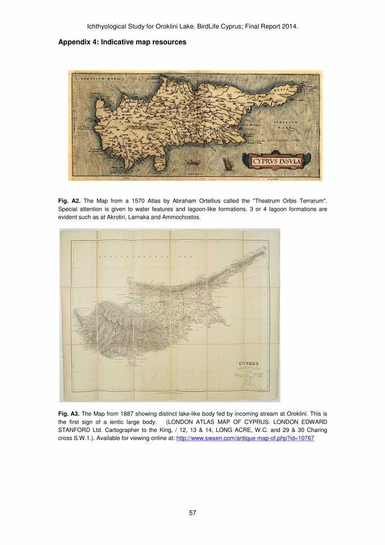
Ichthyological Study for Oroklini Lake. BirdLife Cyprus; Final Report 2014.
57
Appendix 4: Indicative map resources
Fig. A2. The Map from a 1570 Atlas by Abraham Ortellius called the "Theatrum Orbis Terrarum".
Special attention is given to water features and lagoon-like formations. 3 or 4 lagoon formations are
evident such as at Akrotiri, Larnaka and Ammochostos.
Fig. A3. The Map from 1887 showing distinct lake-like body fed by incoming stream at Oroklini. This is
the first sign of a lentic large body. (LONDON ATLAS MAP OF CYPRUS. LONDON EDWARD
STANFORD Ltd. Cartographer to the King, / 12, 13 & 14, LONG ACRE, W.C. and 29 & 30 Charing
cross S.W.1.). Available for viewing online at: http://www.swaen.com/antique-map-of.php?id=10767

Ichthyological Study for Oroklini Lake. BirdLife Cyprus; Final Report 2014.
58
Appendix 5: Site names used in this study / translations
Fig. A4. Main site names and ichthylogical sampling locations
Place name translations
Some of these names are given on maps throughout the report and reproduced in Fig. A4.
Oroklini Lake Wetland – Υγρότοπος Λίµνης Ορόκλινης Oroklini Stream - Αργάκι Ορόκλινης Kambos Wetland – Υγρότοπος Κάµπου Ορόκλινης Highway Canal – Κανάλι Αυτοκινητόδροµου Upper Lake Basin – Πάνω Λεκάνη Ορόκλινης Lower Lake Basin – Κάτω Λεκάνη Ορόκλινης (S7) Upper Basin Weir – Υδροφραγµός Πάνω Λεκάνης (Σηµείο 8) North Canal – Βόρειο Κανάλι South Canal – Νότιο Κανάλι West Oroklini Inland – ∆υτική Ορόκλινη Εσωτερικά (Σηµείο 5) West Oroklini Canal – ∆υτικό Κανάλι Ορόκλινης (εκβολή στο σηµείο 4) East Oroklini Canal – Ανατολικό Κανάλι Ορόκλινης (εκβολή στο σηµείο 7) N-S Canal – Β-Ν Κανάλι
Fish name translations
Mosquitofish (Gambusia holbrooki) – Κουνοπιέρης, Κουνουπόψαρο European Eel (Αnguilla anguilla) - Χέλι (Ασσέλι) Striped Mullet (Mugil cephalus) – Κέφαλος (ή Πόκλανος) Thin-lipped Grey-Mullet (Liza ramada) –Μαυράκι (Είδος Κεφαλόπουλου) Grey Mullet (Liza sp.)- Είδος Κεφαλόπουλου Grey-mullet family (Mugilidae) –Eίδη Κεφαλόπουλων Mediterranean Toothcarp (Aphanius fasciatus) – Ζαµπαρόλα

Ichthyological Study for Oroklini Lake. BirdLife Cyprus; Final Report 2014.
59
Appendix 6 - Summary in Greek / Ελληνική Περίληψη
Η παρούσα µελέτη εστιάζει στην ιχθυοπανίδα του υγροτόπου της Λίµνης Ορόκλινης.
Αυτή η σύντοµη και προκαταρκτική έρευνα προσεγγίζει τα ψάρια από την άποψη της
διατήρησης της βιοποικιλότητας, ειδικά για να τεκµηριωθούν συγκεκριµένα µέτρα
διαχείρισης και προτάσεις για περαιτέρω έρευνα και παρακολούθηση. Συνοπτικά η
µελέτη προσφέρει τα παρακάτω αποτελέσµατα:
a) Περιγράφεται για πρώτη φορά η ιχθυοπανίδα του υγροτόπου µε δειγµατοληψίες και αυτοψίες µε τη χρήση συρόµενου διχτυού (δίχτυ γόνου), απόχες και οπτική παρατήρηση.
b) Ερευνήθηκαν οι τυπο-χαρακτηριστικές συνθήκες αναφοράς του υγροτόπου, δηλαδή οι συνθήκες πριν την αλλοίωση και υποβάθµιση του υγροτόπου. Είναι προφανώς ένας υποβαθµισµένος παράκτιος υγρότοπος που ήταν πιο εκτεταµένος πριν τα έργα αποστράγγισης. Η φυσική µορφή του υγροτόπου αντιστοιχεί σε µικρή παράκτια λιµνοθάλασσα. Σήµερα διατηρεί τεχνητή σύνδεση µε τη θάλασσα δια µέσου δύο αποστραγγιστικών καναλιών. Τα κανάλια αποστράγγισης και οι τεχνητοί τάφροι είναι σηµαντικά και ως καταφύγια για υδρόβιους οργανισµούς διότι ένα µεγάλο µέρος του υγροτόπου ξεραίνετε για µεγάλο διάστηµα τη θερινή περίοδο ενώ αυτά διατηρούν νερό όλο το χρόνο και σύνδεση µε την θάλασσα.
c) Τέσσερα είδη ψαριών καταγράφηκαν στον ευρύτερο χώρο του υγροτόπου (περιλαµβάνοντας και τα κανάλια). Από αυτά, τα σηµαντικότερα ως προς την αφθονία τους είναι το χέλι (Anguilla anguilla) και το κουνοπόψαρο (Gambusia holbrooki). Το κουνοπόψαρο ειναι αλόχθονο είδος. Τουλάχιστον δύο είδη κεφαλόπουλων (Mugilidae) επίσης εισέρχονται τακτικά στα κανάλια από την θάλασσα, ενώ πολύ λίγα άτοµα κεφαλόπουλων φθάνουν στο χώρο της λιµναίας λεκάνης της Λίµνης Ορόκλινης.
d) Η Ορόκλινη είναι µια από τις πιο σηµαντικές περιοχές για το χέλι στην Κύπρο. Εκατοντάδες χέλια εισέρχονται στον υγρότοπο και αποτελούν τµήµα του τροφικού πλέγµατος, είναι και τροφή για ορισµένα ιχθυοφάγα πτηνά. Οι πληθυσµοί χελιών είναι πολύ ευάλωτοι στην εποχική αποξήρανση του υγροτόπου. Το 2013 κατά την περίοδο της ξηρασίας υπολογίσαµε ότι πέθαναν περίπου 1200 χέλια στη λίµνη Ορόκλινης. Το χέλι είναι απειλούµενο είδος, µε παγκόσµια κατάταξη ως «κρισίµως κινδυνεύων» - συνεπώς η σηµασία της Ορόκλινης αναβαθµίζεται αισθητά λόγο της σηµαντικής παρουσίας αυτού του µεταναστευτικού ψαριού εκεί.
e) Τα κουνοπόψαρα (Gambusia holbrooki) είναι γνωστά ως χωροκατακτητικά ξενικά είδη όµως οι ακριβείς επιπτώσεις τους στην φύση δεν έχουν ερευνηθεί στην Κύπρο. Σε υφάλµυρα νερά πρακτικά αντικαθιστούν ένα ιθαγενές ψάρι, την Ζαµπαρόλα (Aphanius fasciatus). Τα δύο είδη µοιάζουν και καλύπτουν παρόµοιο οικολογικό θώκο, όµως η Ζαµπαρόλα ειναι απειλούµενο είδος και στην Κύπρο απαντά σήµερα µόνο στην Αµµόχωστο και στο Ακρωτήρι. Υποθέτουµε ότι η Ζαµπαρόλα κάποτε ήταν πιο διαδεδοµένο είδος στην Κύπρο διότι έχουν υποβαθµιστεί πολύ οι παράκτιοι υγρότοποι και τα συγκεκριµένα ενδιαιτήµατα που απαιτεί. Αντιθέτως τα κουνουπόψαρα είναι πολύ διαδεδοµένα στο νησί, όµως ο πληθυσµός στη Ορόκλινη δεν είναι εξαιρετικά υψηλός. Η ξηρασία (ξήρανση υδάτινων ενδιαιτηµάτων) καθώς και η υψηλή αλατότητα επιδρά και προφανώς ταπεινώνει τους πληθυσµούς του είδους στην Ορόκλινη. Το 2013 και 2014 οι πληθυσµοί του κουνοπόψαρου δεν ήταν πουθενά σε υψηλές πυκνότητες για να υπάρχουν ενδείξεις για ανησυχία σχετικά µε τις επιπτώσεις του ξενικού είδους στο οικοσύστηµα.
Ichthyological Study for Oroklini Lake. BirdLife Cyprus; Final Report 2014.
60
Προτάσεις διατήρησης, αποκατάστασης, παρακολούθησης, έρευνας:
Η χωρική έκταση της προστατευόµενης περιοχής είναι πολύ περιορισµένη και δεν
προστατεύεται το παρόχθιο τοπίο ή η έκταση που τροφοδοτεί την λίµνη µε νερό.
Βασικό είναι να εξασφαλιστεί µια συνεκτικότητα και οικολογική σύνδεση της Λίµνης µε
καθαρά νερά από τα ανάντη, καθώς και η σύνδεσή της (µέσω των δύο καναλιών) µε
τη θάλασσα. Τα χέλια και άλλα αυτόχθονα είδη ψαριών εξαρτώνται απόλυτα από την
ανεµπόδιστη κίνηση τους µεταξύ υγροτόπου και θάλασσας. Τα κανάλια όπως και µια
ευρύτερη χερσαία έκταση γύρω από την λίµνη καθώς και τµήµα του υγροτόπου του
Κάµπου θα πρέπει να εισέρθουν σε προστατευόµενη περιοχή για να εξασφαλιστεί η
συνολική ακεραιότητα του οικοσυστήµατος.
Ο υγρότοπος είναι σήµερα σε πολύ υποβαθµισµένη µορφή σε σχέση µε τη φυσική
εικόνα που θα είχε στο παρελθόν η λεκάνη. Επειδή επιδρούν διάφορες
ανθρωπογενείς πιέσεις είναι απαραίτητη η διαχείρισή του για την ανόρθωση και
αποκατάσταση στοιχείων της αυτόχθονης βιοποικιλότητας. Ως προς τα σηµαντικά
γνωρίσµατα της ιχθυοπανίδας, αναφέρουµε συγκεκριµένες προτάσεις:
- Απαιτείται ειδική µέριµνα για τη µείωση των εµποδίων που αρνητικά επιδρούν στη µετανάστευση/µετακίνηση ψαριών από τη θάλασσα.
- Τους θερινούς µήνες τα αυτόχθονα ψάρια της λεκάνης απαιτούν καταφύγια λόγο της τάχιστης συρρίκνωσης των νερών. Ορισµένα σηµεία ενδείκνυνται για τη δηµιουργία καταφυγίων (όπου µπορούν να διατηρούνται περιοχές µε βαθύτερα καθαρά νερά (η περιοχή εισροής νερού από το αργάκι της Ορόκλινης αφού εισέρθει κάτω από τον αυτοκινητόδροµο – στο βόρειο µέρος της Λεκάνης).
- Κατά την ξηρασία, απλά µέτρα µετακίνησης των χελιών (µε την χρήση αποχών) πρέπει να εφαρµόζονται. Τα χέλια µπορούν να ελευθερωθούν στο «καταφύγιο» της τάφρου του αργακιού Ορόκλινης (εκεί που εισέρχεται από τον αυτοκινητόδροµο) καθώς και στο ∆υτικό κανάλι Ορόκλινης. ∆εν θα πρέπει να µεταφέρονται κατευθείαν στη θάλασσα.
- Ειδικές δοµές για το «πέρασµα χελιών» θα τοποθετηθούν σε ένα εµπόδιο (τον υδατοφραγµό) για να περάσουν νεαρά ανοδικά χέλια. Τέτοιες παρεµβάσεις είναι σηµαντικές και µπορεί να κατασκευαστούν και αλλού µετά απο εξέταση των εµποδίων για τα χέλια.
- Ως ειδικές ερευνητικές προσεγγίσεις για ειδικά µέτρα αποκατάστασης είναι τα εξής:
i) Ερευνητικό πρόγραµµα για την εισαγωγή της Ζαµπαρόλας (Aphanius fasciatus) µε την µεταφορά ψαριών απο το Ακρωτήρι θα πρέπει να µελετηθεί και να εφαρµοστεί.
ii) Τα χέλια απαιτούν ειδική έρευνα στην λίµνη. Η βιολογία και οικολογία τους καθώς και τα συγκεκριµένα εµπόδια στις µετακινήσεις και την διαβίωσή τους τούς θερινούς µήνες απαιτούν ειδική µελέτη που θα πρέπει να αναπτύξει και ειδικές προτάσεις διατήρησης και µέτρων διευκόλυνσης της µετανάστευσής τους.
iii) Απαραίτητη είναι η επιστηµονική παρακολούθηση.
Τα ψάρια του υγροτόπου Λίµνης Ορόκλινης θα µπορούσαν να είναι σηµαντικό στοιχείο για την προώθηση της διαχείρισης και αποκατάστασης του οικοσυστήµατος στηριζόµενο στην έρευνα. Σηµαντικό ειναι να υπάρξει ειδική µνεία στην ευαισθητοποίηση της κοινωνίας για το θέµα αυτό.
Recommended


