City of Albany City of Cohoes
City of Rensselaer City of Troy
City of Watervliet Village of Green Island
Green Infrastructure Toolkit

Project Manager
Martin Daley
Capital District Regional Planning Commission
One Park Place, Suite 102
Albany, NY 12205
(518) 453-0850
www.cdrpc.org
Project Team
Barton & Loguidice, DPC
Harris Beach, PLLC
Ryan Biggs | Clark Davis Engineering & Surveying, DPC
O’Brien & Gere, Inc.
This project has been funded by the New York Department of State under the Local Government
Efficiency Grant Program.
Albany Pool Communities
Map of Albany Pool Communities

Albany Pool Communities - Contacts
Green Infrastructure Toolkit3
City of Albany William Simcoe [email protected]
City of Cohoes Garry Nathan [email protected]
Village of Green Island Maggie Alix [email protected]
City of Rensselaer Mark Hendricks [email protected]
City of Troy Chris Wheland [email protected]
City of Watervliet Dave Dressel [email protected]
Stormwater Coalition Of Albany County Nancy Heinzen [email protected]
Rensselaer County Linda C. von der Heide [email protected]
Other Stormwater Partners:

Green Infrastructure Toolkit - Table of Contents
Green Infrastructure Toolkit4
5 Mission Statement
6 Use and Objectives
8 Changes from Design Manual
9 What are Green Infrastructure Practices?
10 Other Strategies to Reduce CSOs
11 GI Practices
13 Runoff Reduction Sizing
14 Runoff Reduction Volume
15 Practice Selection Flow Chart
16 Options to Reduce Impervious Cover
17 Impervious Area Reduction
18 Disconnected Runoff
19 Tree Planting
20 Porous Pavement
25 Green Roofs
31 Infiltration Practices
34 Infiltration Basin
35 Infiltration Trench
36 Infiltration Chambers & Drywells
37 Shallow Soil Systems
39 Infiltration Sizing Example – Infiltration Trench
40 Local Infiltration Project
41 Bioretention Practices
42 Rain Gardens
44 Stormwater Planters
48 Bioretention Area
54 Vegetated Swale
56 Rainwater Harvesting
57 Rain Barrels
58 Cisterns
61 Flow Through Practice
68 Planning Tips
70 Planning Guide – GI Banking System and Vacant Lots
72 Pretreatment Guide
75 Soils and Infiltration Testing
76 Planting Guide
77 Bioretention Soils Guide
78 Underdrain Guide
79 Cost of GI Practices
81 Construction Considerations
82 Maintenance Considerations
84 Maintenance Tasks
87 Maintenance Costs
88 Lessons Learned
90 Local GI Projects
92 Additional References
93 Glossary

Mission Statement
Green Infrastructure Manual5
To provide customizable green alternatives to traditional stormwater management on small sites to promote:
• greener landscapes
• reduction of heat island effect
• removal of stormwater pollutants
• reduction in the incidences of combined sewer overflows

Use and Objectives
Green Infrastructure Toolkit6
This Toolkit is intended for use on non-residential projects that disturb less than or
equal to 1 acre.
The New York State Department of Environmental Conservation (NYSDEC) and
the local Municipal Separate Storm Sewer (MS4) requirements apply to projects
that disturb more than 1 acre. http://www.dec.ny.gov/chemical/43150.html
This Toolkit is intended to supplement the NYSDEC Stormwater Management
Design Manual (Design Manual). Practices and definitions included in the Design
Manual are acceptable for use on some smaller sites.
http://www.dec.ny.gov/chemical/29072.html
Some of the Design Manual requirements have been relaxed or modified to make
green infrastructure (GI) practices easier to adopt for small and challenging sites,
particularly urban redevelopment projects.

Use and Objectives
Green Infrastructure Toolkit7
The Albany Pool Communities (APC) are comprised of five Cities and one Village, each
with their own local land use codes. This GI Toolkit is intended to serve as an aid to wider
adoption of GI Infrastructure, but local requirements will continue to remain in effect.
As a parallel project to this GI Toolkit, the Capital District Regional Planning Commission
and Barton & Loguidice have reviewed the APC local laws and guidance documents in an
effort to promote green infrastructure. This project included:
Research of best practices used in other communities.
Identified gaps in the local laws and guidelines.
Drafted a model local law for consideration by the Albany Pool Communities
The City of Albany adopted a Unified Sustainable Development Ordinance (USDO) in
May 2017. Of note, this ordinance requires:
Projects that disturb more than ¼ acre must comply with the NYSDEC Design Manual.
Post development peak runoff must not exceed the existing peak runoff for the10 year storm
event.
Properties ¼ acre or smaller must either; detain the first 1 inch of rainfall and direct 100% of
the rooftop and 75% of surface stormwater flows to a tree well, drainage swale, raingarden,
or underground cistern; or install a green or blue roof.

Changes from NYS DEC Stormwater Design Manual
Green Infrastructure Toolkit8
Only Applies to sites 1 acre or less.
Applies to both new and redevelopment sites.
Focuses on reduction of the runoff volume (RRv). The RRv calculation is simplified to 1" of rain times the
directly connected impervious areas of the site.
Establishes a hierarchy for GI practice selection:
• Reduce Impervious areas.
• Use infiltration practices where feasible.
• Use Flow through practices only where infiltration is not feasible.
RRv requirements can be met by reducing the existing impervious area by 15%.
Increases impervious area reduction credit for tree planting from 100 ft2 to 150 ft2.
Reduces pretreatment requirements.
Reduces separation distance to groundwater from 3' to 2'.
Reduces minimum infiltration rate required for infiltration practices from
0.5"/hour to 0.2"/hour.
Increases maximum time to drain practices to 3 days.
Increases allowed ponding depth for bioretention areas from 6″ to 1'.
Requires flow through practices to slowly release the RRv over 72 hours if possible.
Reduces minimum orifice size to ½" diameter when using underdrains to allow for slower release rates.
Allows infiltration to area of shallow permeable soils, including fill soils.
Relaxes requirements for disconnected runoff.

What are Green Infrastructure Practices?
Green Infrastructure Model Local Law Project9
As land becomes developed and urbanized, the addition of roofs, streets and other
impervious areas increase the volume and rate of stormwater runoff.
Green Infrastructure (GI) practices are stormwater management features designed to
reduce the volume of stormwater runoff (RRv) and reduce the pollutants in stormwater
discharges from the site.
GI practices that reduce impervious areas directly reduces the RRv. For storms of up to
1", most, if not all of the rain that falls on pervious areas is retained with the soils,
vegetation or in small depressions. In contrast, almost all of the rain that falls on
impervious surfaces results in runoff.
GI infiltration practices allow stormwater to seep into the ground rather than run off the
site and should be the first choice to manage stormwater from impervious surfaces.
Other GI practices remove pollutants and slow down the rate of discharge through the
use of temporary storage.
Many GI practices use carefully selected plants and soils, configured to help in treatment.
Other Strategies to Reduce CSOs
Green Infrastructure Toolkit10
While not the focus of this toolkit, practices which reduce the peak runoff from
sites for larger storm events such as the 10 year (Q10) and 100 year (Q100)
storms will help reduce the frequency of Combined Sewer Overflows (CSO).
Peak runoff reduction is typically achieved by providing storage and releasing the
stormwater at a controlled (lower) rate than would otherwise occur.
Stormwater may be stored in a wet or dry pond or in a variety of underground
structures including vaults, pipes or chambers.
Blue roofs provide the storage of stormwater on building roofs.
Some municipalities, such as Chicago, encourage the storage of up to 12" of
stormwater on parking lot surfaces.
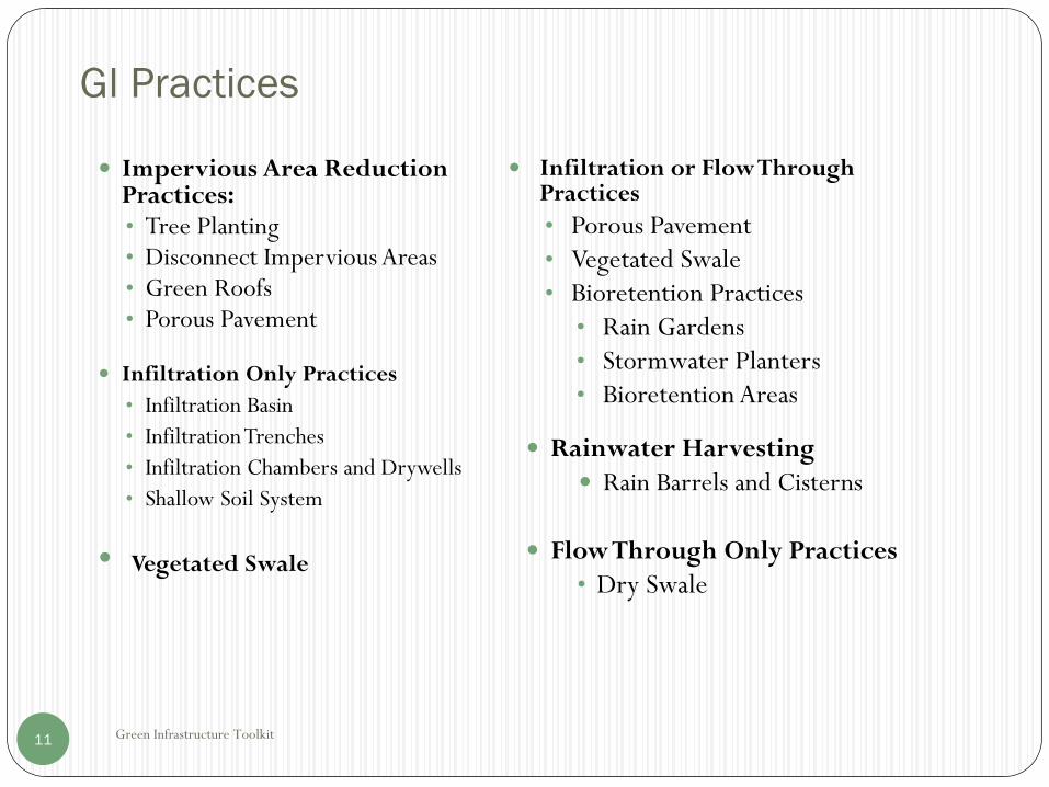
GI Practices
Green Infrastructure Toolkit11
Impervious Area Reduction Practices:• Tree Planting• Disconnect Impervious Areas• Green Roofs• Porous Pavement
Infiltration Only Practices
• Infiltration Basin
• Infiltration Trenches
• Infiltration Chambers and Drywells
• Shallow Soil System
Infiltration or Flow Through Practices
• Porous Pavement• Vegetated Swale• Bioretention Practices
• Rain Gardens• Stormwater Planters• Bioretention Areas
Rainwater Harvesting
Rain Barrels and Cisterns
Flow Through Only Practices
• Dry Swale• Vegetated Swale

Additional GI Practices
Green Infrastructure Toolkit12
The Design Manual discusses several other GI Practices which generally take up
more space than is typically available for sites less than 1 acre, but can be used if
space permits. Refer to the Design Manual for further information.
http://www.dec.ny.gov/chemical/29072.html
These practices include:
• Conservation of Natural Areas.
• Sheet-flow to Riparian Buffers or Filter Strips.
• Stream Daylighting.
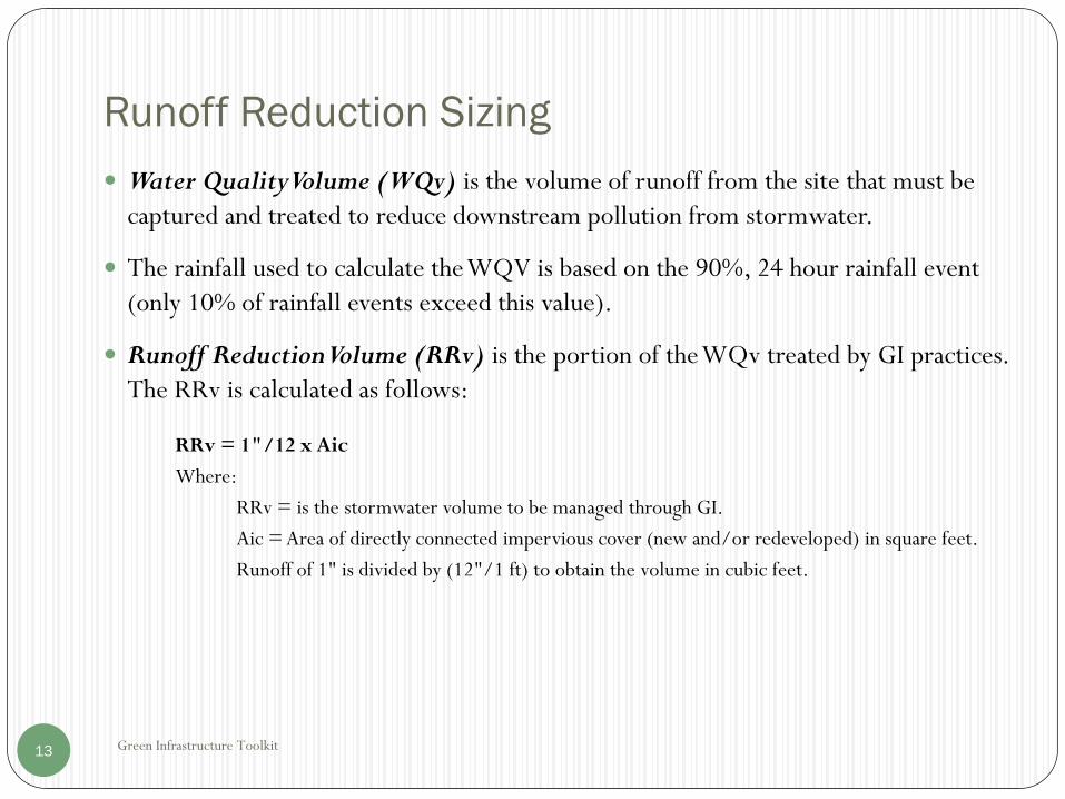
Runoff Reduction Sizing
Green Infrastructure Toolkit13
Water Quality Volume (WQv) is the volume of runoff from the site that must be
captured and treated to reduce downstream pollution from stormwater.
The rainfall used to calculate the WQV is based on the 90%, 24 hour rainfall event
(only 10% of rainfall events exceed this value).
Runoff Reduction Volume (RRv) is the portion of the WQv treated by GI practices.
The RRv is calculated as follows:
RRv = 1"/12 x Aic
Where:
RRv = is the stormwater volume to be managed through GI.
Aic = Area of directly connected impervious cover (new and/or redeveloped) in square feet.
Runoff of 1" is divided by (12"/1 ft) to obtain the volume in cubic feet.
Runoff Reduction Volume
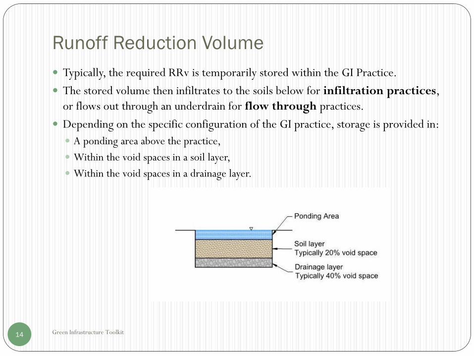
Green Infrastructure Toolkit14
Typically, the required RRv is temporarily stored within the GI Practice.
The stored volume then infiltrates to the soils below for infiltration practices,
or flows out through an underdrain for flow through practices.
Depending on the specific configuration of the GI practice, storage is provided in:
A ponding area above the practice,
Within the void spaces in a soil layer,
Within the void spaces in a drainage layer.

Green Infrastructure Toolkit15
Practice Selection Flow Chart
Let’s get started…..
• Plan to reduce area of roofs, parking lots and other impervious surfaces.
• Maintain grass areas, buffers, sensitive resources.
• See Planning Tips.
• Determine the Runoff Reduction Volume (RRv) for the site.
• The RRv is the amount of stormwater to be collected and managed through green infrastructure practices to reduce pollution and downstream impacts.
• Check Soils. If Hydraulic Soil Group (HSG) A or B then maximize use of infiltration practices.
• HSG C or D soils may not be suitable for infiltration. See Soils and Infiltration Testing.
• Apply other GI practices to manage the remaining RRv after applying infiltration practices have been utilized to the maximum extent feasible.

Options to Reduce Impervious Cover
Green Infrastructure Toolkit16
Before continuing; check that you have looked at the Planning Tips and see that you have taken every opportunity to reduce the area of impervious cover (Aic).
There are several other GI practices that provide impervious area reduction:
• Disconnected Impervious Areas:• Rather than discharging directly to a stormwater system, runoff from impervious areas is discharged
to pervious areas of the site.
• Any disconnected impervious areas can be subtracted from the Aic used to calculate the RRv.
• Tree Plantings• Up to 150 square feet per tree can be subtracted from the Aic.
• Porous Pavement• Replace impervious asphalt pavement and concrete with porous alternatives.
• Green Roof• Replace impervious roofs with a green roof system.
Impervious Area Reduction
Green Infrastructure Toolkit17
Reducing the area of impervious cover directly reduces both the volume of runoff
and the peak discharge from the site for all storm events.
For the purposes of this Tool Kit, a project that reduces the
impervious cover area by 15% from existing conditions
has satisfied the RRv Requirements.

Disconnected Runoff
Green Infrastructure Toolkit18
To count as disconnected runoff:
• Contributing flow path over impervious area must be ≤ 75‘.
• Disconnected impervious area must be ≤ 2,000 ft2.
• Provide level spreaders where impervious area is > 500 ft2.
• Drain to grass/landscaped area with slope ≤ 5%.
• Drainage shall continue across landscape area for a minimum
distances of 50'.
Resources:
City of Portland Downspout Disconnection Program:
https://www.portlandoregon.gov/bes/54651

Tree Planting
Green Infrastructure Toolkit19
Plant new trees to replace any trees removed by project.
To receive area reduction credit:
• Plant new trees within 10' of impervious area.
• Credit allowed for preserved trees with canopies ≤ 20' from impervious area.
Subtract the tree area credit from the area of impervious cover as follows:
• Subtract 150 ft2 for each tree with a mature canopy diameter of 16‘.
• Subtract ½ of the canopy area for each tree with mature canopy diameters of < 16'.
• Planted trees must be 2" minimum caliper for deciduous and 6' tall for evergreen.
• The City of Albany Street Tree program picks up ½ the cost of planting trees within the City
right of way. See:
http://www.albanyny.gov/Libraries/General_Services/Tree_Planting_2017_-_4_page_-
_Updated.sflb.ashx
• Plant urban tolerant species: http://www.hort.cornell.edu/uhi/outreach/recurbtree/
• For a homeowner’s guide to tree planting, see: http://chesapeakestormwater.net/be-bay-
friendly/tree-planting/

Porous Pavement
Green Infrastructure Toolkit20
Under the general term of “Porous Pavement” there are a number of variations
depending on function and materials. In all cases, the objective is to provide a GI
alterative to traditional asphalt and concrete sidewalks, drives and parking areas.
Porous surface options:
• Porous asphalt.
• Porous concrete.
• Permeable Pavers – concrete or clay bricks where water flows through the joints.
• Porous pavers - typically grid of concrete or plastic with grass or stone infill.
• Pervious pavers – manufactured permeable pavers.
References:Porous Asphalt: http://www.asphaltpavement.org/index.php?option=com_content&view=article&id=359&Itemid=863
Porous Concrete: http://www.perviouspavement.org/
University of New Hampshire Stormwater Center: http://www.unh.edu/unhsc/
Permeable Pavers: https://www.icpi.org/paving-systems/permeable-pavers
Porous Pavement Sizing
Green Infrastructure Toolkit21
Stormwater passing through a porous pavement is typically stored in the subbase
under the surface.
In addition to stormwater storage, the subbase must provide a suitable foundation
to support traffic or pedestrian loads.
At a minimum, the storage volume should be sized to store the RRv resulting from
rain falling directly on the porous pavement.
By providing additional storage capacity, the porous pavement areas can handle the
RRv from other impervious areas of the site.
The storage capacity of the subbase is based on the area, depth, and porosity of the
subbase. A typical open graded stone subbase will have a porosity of 0.4.
Where soils are suitable, stormwater temporarily stored in the subbase will
infiltrate into the ground. See Infiltration Practices.
Where soils are less permeable (<0.2"/hour) underdrains will be required.

Porous Pavement
Green Infrastructure Toolkit22
• For traffic areas, a special asphalt mix is used which allows water to seep through
the surface.

Porous Pavement
Green Infrastructure Toolkit23
For low traffic and non traffic areas, porous asphalt or porous concrete can
be used as the surface. Alternatively, there are a wide number of
manufactured products that can be used including:
• Stormcretetm.
• FILTERPAVE ®.
• KBI Flexi®-Pave.
• Pavers such as; Unilock ® Belgard ® and EP Henry.
• Plastic turf or gravel systems such as;Truegrid ®, Invisible Structures, NDS ®.

Porous Pavement
Green Infrastructure Toolkit24
Permeable pavers may also be used without providing storage underneath when
placed on permeable soils (HSG A or B).
Plastic reinforced turf systems can be used to provide emergency access. While
not suitable for frequent traffic, there are options that can support heavy vehicles,
including fire trucks.
Homeowner’s reference for installing permeable pavers:
http://chesapeakestormwater.net/be-bay-friendly/permeable-hardscapes/
Green Roof
Green Infrastructure Toolkit25
Green roofs offer many benefits other than stormwater management including;
reducing the urban heat island effect, lowering heating and cooling costs, filtering air
borne contaminants, providing fire resistance, providing bird and butterfly habitat,
and can be aesthetically pleasing.
Green roofs are considered pervious and therefore directly reduce the area of
impervious cover (Aic) and resulting RRv.
Additional green roof storage can be provided to treat RRv from adjacent
impervious areas.
Parking garage roofs are an excellent opportunity for the application of green roofs.
The design of green roofs is integral to the building design and should be done by
the design professional. Refer to the Design Manual for additional information. http://www.dec.ny.gov/docs/water_pdf/swdm2015chptr05.pdf
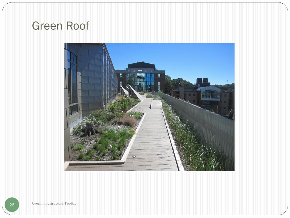
Green Roof
Green Infrastructure Toolkit26
Green Roof Detail
Green Infrastructure Toolkit27

Green Roofs in the Capital Region
Green Infrastructure Toolkit28
Photo Credit: Albany Times Union
Doane Stuart School, Troy, NY• 22,000ft2 multi-use green roof system
• Project design and construction funded through a
$1.4 million EFC GIGP grant
• Stormwater runoff reduction of 50%-90%
• http://www.doanestuart.org/academics/green-
roof-2/

National Examples of Green Roofs
Green Infrastructure Toolkit29
Javits Center, New York City• 6.75 acre greenroof
• Captures 6.8 million gallons of
stormwater per year
• http://www.nydailynews.com/lif
e-style/big-town/raising-roof-
article-1.1975080
World Wildlife Federation Building,
Washinton D.C.• 28,000ft2 green roof
• http://www.greenroofs.com/projects/pview.ph
p?id=1334

Green Roof Resources
Green Infrastructure Toolkit30
http://www.dec.ny.gov/lands/58930.html#Green
https://www.greenroofs.org/resources/
https://www.wbdg.org/resources/extensive-vegetative-roofs
http://www.greenroofguide.co.uk/design/
https://www.epa.gov/heat-islands/using-green-roofs-reduce-heat-islands
https://www.epa.gov/heat-islands/green-roofs-stormwater-management-and-
urban-heat-island-mitigation

Infiltration Practices
Green Infrastructure Toolkit31
After implementing Aic reduction through planning and GI practices which reduce
impervious areas, the next step is to maximize RRv reduction through infiltration.
Infiltration Practices Include:
Infiltration Basin: Round or more linear swale, typically grass covered.
Infiltration Trench: Open graded stone trench with grass or peastone surface.
Infiltration Chambers and Drywells:
• Subsurface structure used to increase the available storage volume.
• Typically concrete or plastic surrounded by sand or stone.
• Can be traffic rated and installed under parking lots and roads.
• Shallow Soil System: Similar to infiltration trench with a larger area of shallow infiltration
stone or permeable soil.
Infiltration Practices
Green Infrastructure Toolkit32
In addition to these practices, there are a number of GI practices can be designed as either
infiltration systems or flow through systems with underdrains. Use the infiltration type
systems whenever possible:
• Porous Pavement with infiltration
• Bioretention Area with infiltration
• Stormwater Planter with infiltration
Underdrains from Flow Through GI practices can be directed to infiltration practices.
Design guidance:
• All infiltration practices require suitable soils with a minimum infiltration rate of
0.2"/hour. (reduced from Design Manual minimum of 0.5"/hour).
Refer to Soils and Infiltration Testing.
• Maintain a minimum of 2' separation to groundwater or bedrock. Greater separation
distance may be required for “hot spots” , over aquifers, or as required by local
requirements.
• Keep infiltration practices 10' away horizontally from buildings and foundations and
100' from onsite wells.
Infiltration Practices
Green Infrastructure Toolkit33
Design guidance:
Existing soils that will receive infiltration should be protected from over compaction
or siltation during construction. De-compaction of previously disturbed soils may
be required.
A conservative approach is recommended, especially when using soils with lower
infiltration rates. Consideration should be given to:
Providing overflows and/or underdrains.
Applying a safety factor to measured infiltration rates.
Oversize the infiltration area provided.
Keep ponding depth ≤ 12" and time to drain < 3 days. Ponding and standing water
can be a safety and insect breeding concern.
Geotextiles are often used to keep adjacent fine soil particles from entering the
infiltration practice. Care and judgement should be used however, because excessive
fines in the stormwater can plug geotextile surfaces.

Infiltration
Green Infrastructure Toolkit34
INFILTRATION BASIN

Infiltration
Green Infrastructure Toolkit35
INFILTRATION TRENCH

Infiltration Chambers & Drywells
Green Infrastructure Toolkit36
Drywell
Storm Chambers

Infiltration Practices
Green Infrastructure Toolkit37
Shallow Soil System
• Stormwater from small impervious areas can be directed to a shallow soil system.
• A shallow soil system consists of a 1' to 2' layer of soil, either native or imported fill.
(This is a variance from the Design Manual which does not allow infiltration in fill).
• Existing disturbed soils should be restored (see Design Manual, 5.1.6).
• The upper 4" layer is topsoil to support turf. The soil below can be native permeable
soils or imported fill.
• The shallow soil system is designed to store the RRv within the void spaces in the 1' to
2' depth of soil. Porosities will vary from 0.2 for topsoil to 0.4 for drainage stone.
• Underdrains and/or surface overflows will be needed where the underlying soils are
poor (< 0.2"/hour infiltration).

Shallow Soil System
Green Infrastructure Toolkit38

Infiltration Sizing Example – Infiltration Trench
Green Infrastructure Toolkit39
Infiltration Trench
Infiltration Practices are sized to store the RRv which infiltrates to the soils below.
Item Input Units Notes
Runoff Reduction Volume, RRv 1000 ft3
Depth of Infiltration Practice, dp 36 inches
Soil Infiltration Rate, Ir 0.5 "/hr Minimum of 0.2"/hr
Time to Drain,t = d/Ir 72 hours Maximum 72 hours
Area of Practice, Ap 900 ft2
Porosity of Drainage Stone, nd 0.4 Typically 0.4 for drainage stone
Volume in Practice, Vp=Ap*dp/12*nd 1080 ft3
Volume OK? OK If Vp<RRv increase area or depths
Note: Calculations are similar for drywells and storm chambers, except that the volume in the practice,
includes the open volume in the drywell or storm chambers, plus the volume available in the drainage stone.
Local Infiltration Project: Ryckman and Hansen
Overflow Abatement Project, City of Albany, NY
Green Infrastructure Toolkit40
• The project is located in Woodlawn Park to the Hansen
Avenue and Ryckman Avenue intersection in the City of
Albany, New York
• To provide abatement of system surcharging and flooding in
Hansen Alley, flows collected along Hansen Alley have been
diverted to an underground infiltration gallery located in
Woodlawn Park. Flow has been diverted through a series of
pipes and structures that run south along West Erie Street
and then southeast along Woodlawn Avenue. The existing
underground detention system in the alley and underground
infiltration gallery capture, detain, and infiltrate flows from
the Hansen Alley watershed area.
• Abatement of system surcharging and flooding in Ryckman
Alley has been achieved through a constructed wetland
system south of the Alley consisting of a wet pond, plunge
pool, micro-pool and assortment of aquatic plant life. The
existing underground detention system and wetland system
capture, detain, and mitigate flows from the Ryckman Alley
watershed area. Collectively, these practices provide for the
storage of over a million gallons.
Bioretention Practices
Green Infrastructure Toolkit41
Overview
• Selected plants & soils used to retain and treat stormwater.
• Can be infiltration type (preferred) or flow through type.
• The Design Manual describes bioretention areas, rain gardens and stormwater planters.
These are all bioretention practices. The terminology may vary between references.
Where to use
• Use for roof runoff, paved plazas or sidewalk areas, parking lot medians and along
drives.
Bioretention – Infiltration Type
• Use as first choice if soils are suitable (infiltration rate > 0.2 inches/hour).
• Keep infiltration areas at least 10 feet away from basements.
Bioretention – Flow Through Type
• Requires underdrain with discharge to storm system or separate infiltration practice.
• Provides water quality treatment, temporary storage of the RRv and some reduction in
peak runoff when the release rates are controlled.
Rain Gardens
Green Infrastructure Toolkit42
Shallow depression that collects runoff.
Used to treat smaller impervious areas
- up to 1,000 ft2.
6" ponding depth, 12" to 18" soil
media, 6" to 12" stone storage area
under soil media.
Sized as infiltration practice

Rain Gardens
Green Infrastructure Toolkit43

Stormwater Planters
Green Infrastructure Toolkit44
Above or below grade wood or concrete container with soil media placed in
structure.
Used to treat areas up to 15,000 ft2.
Contained Planters – do not treat adjacent areas. Reduces the impervious area by
the area of the contained planter.
Stormwater Planters – Infiltration is the preferred practice if soils are acceptable.
Stormwater Planters – Flow Through, use underdrain with discharge.
Typical construction includes 6" to 12" ponding depth, 18" soil media, 12" stone
storage area under soil media.

Stormwater Planter
Green Infrastructure Toolkit45

Stormwater Planter – Infiltration Type
Green Infrastructure Toolkit46
Stormwater Planter – Flow Through Type
Green Infrastructure Toolkit47

Bioretention Area
Green Infrastructure Toolkit48
Unlined or lined with curbing.
Used to treat areas up to 5 acres.
Pretreatment is important for larger impervious areas.
Use Infiltration Type when soils have adequate infiltration.
Flow Through Type - use underdrain with discharge to storm sewer system.
Typical construction includes 6" to 12" ponding depth, 2.5' to 4' soil media.
Bioretention Area
Green Infrastructure Toolkit49

Bioretention Areas - Design Elements
Green Infrastructure Toolkit50
Pretreatment Stone or splash block at inlets and roof
leaders. Stone diaphragm at pavement edges. Additional pretreatment for large paved
areas:Grass filter stripsSediment basinsProprietary pretreatment devices
See Pretreatment Guide
Ponding Area above soilsTypically 6" to12“.Provides temporary stormwater storage.
Plants Select for periodic flooding. Use native, non-invasive species. See Planting Guide
Planting Soils 18" minimum. Typically 2.5' to 4'. Sandy loam. Mulch layer recommended on top. See Bioretention Soils Guide.
Drainage Layer and Underdrains Drainage Stone under soil media. Increases Storage Volume. Geotextile for soils separation. Infiltration Type – infiltrates to soils
below, or; Flow Through Type – Underdrain
conveys stormwater to outlet or downstream practice.
Perforated or slotted underdrain pipe, typically 4" or 6" diameter.
See Underdrain Guide

Bioretention Area
Green Infrastructure Toolkit51

Bioretention Sizing Example – Infiltration
Green Infrastructure Toolkit52
Bioretention Area - Infiltration
Bioretention area is sized to store the RRv which infiltrates to the soils below.
Volume = Volume Ponding + Volume Soil Media + Volume Drainge Layer
Volume Soil Media = Area x Depth Soil Media x Porosity
Volume Drainage Layer = Area x Depth Drainage Layer x Porosity
Item Input Units Notes
Runoff Reduction Volume, RRv 1000 ft3
Soil Infiltration Rate 0.5 "/hr Minimum of 0.2"/hr
Bioretention Area Provided, A 600 ft2
Depth of Ponding, dp 1 ft
Vp = A*dp 600 ft3
Depth Soil Media, ds 2.5 ft Typically 2.5'-4'
Porosity of Soil Media, ns 0.2 Typically .2-.25
Vsm = A*ds*ns 300 ft3
Depth of Drainage Layer, dl 1 ft Optional 0.5' to 1' of stone below
Porosity of Drainage layer, nd 0.4 Typically 0.4 for drainage stone
Vdl = A*dl*nd 240 ft3
Volume Provided,
Vp=Vp+Vsm+Vdl 1140 ft3
Volume OK? OK If Vp<RRv increase area or depths

Bioretention Sizing Example – Flow Through
Green Infrastructure Toolkit53
Bioretention Area - Flow Through
Area of practice is sized to store the RRv as ponding above soil media
Required Area, A = (RRv)/dp
Average height water above bed, havg= dp/2
Hydraulic gradient, i=(ds+havg)/ds
Flow through filter, Q = (k)(i)(A)
Time to Drain, t = RRv/Q
Item Input Units Notes
Runoff Reduction Volume, RRv 1000 ft3
Depth of Ponding, dp 1 ft Maximum 1’
Required Area, A = 1000 ft2
Depth Soil Media, ds 2.5 ft Typically 2.5'-4'
Soil Permeability, k 0.5 ft/day Typically 0.5 to 2 ft/day
Avg. height water above bed, havg .5 ft
Hydraulic gradient, i 1.2
Flow through Practice, Q 600 ft3/day
Time to Drain, t 1.67 days Maximum 3 days

Vegetated Swale
Green Infrastructure Toolkit54
A vegetated swale is a landscaped trapezoid or parabolic shaped ditch.
For small sites, vegetated swales without an outlet may be used to satisfy the requirements for disconnection runoff. In these cases, after the required travel length (50'), the swale can overflow to the site or to an off-site storm sewer system.
Vegetated swales can be used in place of pipes to convey stormwater.
Requirements:
• Flow velocity of < 1 ft/sec at a design flow < 3 cfs.
• Bottom width 2' to 6'.
• Side Slopes no steeper than 3 horizontal to 1 vertical.
• Where used for conveyance, size to handle a 10 year storm with flow velocity < 5 ft/sec with a freeboard of ≥ 6".
• Maximum slope of 4%.

Vegetated Swale
Green Infrastructure Toolkit55
Sizing – refer to Design Manual
• Calculate the peak 10 year (Q10) and peak water quality flow (Qwqv).
• Use Manning Equation to calculate flow depths and velocities to verify requirements have
been met.
Provide 4" of topsoil and use a durable seed mix to establish turf. See Planting Guide.
A RRv Credit shall be applied as follows (based on the soil types):
• After subtracting the RRv credit, the remaining RRv should be treated by another GI
practice.
HSG A or B Soils 20%
HSG C or D Soils 10%

Rainwater Harvesting
Green Infrastructure Toolkit56
Rainwater harvesting uses rain barrels or cisterns to store rainwater for reuse.
Reuse options include lawn and landscape irrigation, car washing, flushing toilets, and other non potable water uses.
This practice directly reduces the RRv by the amount of rain barrel or cistern storage provided.
Common elements include:
• Water tight container/structure of suitable materials including concrete, wood, metal and plastic.
• Secure cover, mosquito/debris screen, inlet screen or filter, overflow pipe, drain valve and tap or pump to withdraw water from storage for reuse.
The rain barrel or cistern must be actively managed. The collected rainwater must be drained or used between storm events so that the storage volume is available for the next storm.
The rain barrel or cistern typically must be drained in winter months.

Rainwater Harvesting – Rain Barrels
Green Infrastructure Toolkit57
Rain Barrels are typically under 100 gallons in size.
Typically a rain barrel is placed at each downspout.
The Syracuse “Save the Rain” program is a model community project. One of the Save The Rain projects is the distribution of free rain barrels provided by Onondaga County to homeowners in the City of Syracuse. In order to receive a rain barrel, homeowners must attend a brief instructional workshop and sign a Rain Barrel Agreement Form. http://savetherain.us/str_project/rain-barrel-program/
Homeowner’s guide: http://chesapeakestormwater.net/be-bay-friendly/rainwater-harvesting/ and http://sfwater.org/index.aspx?page=178
Rainwater Harvesting –Cisterns
Green Infrastructure Toolkit58
Cisterns are larger storage tanks of 100 gallons or more.
Cisterns can be located above or below ground.
Traffic rated tanks can be placed under parking areas.
Precast concrete tanks used for septic systems are an economical choice.
Reuse of rainwater for flushing of toilets is more complicated but is a good
option that provides a year round reuse of rainwater and a potentially large
savings on water bills. Plumbing codes must be carefully followed to
prevent the potential for cross contamination of the potable water system.
The Capital Roots project is a great local example. See Local GI Projects

Rainwater Harvesting - Cistern
Green Infrastructure Toolkit59
Example of Complete
Cistern System from
Orenco Systems®, Inc.
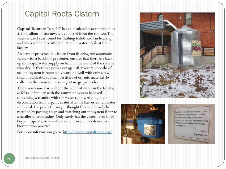
Capital Roots Cistern
Green Infrastructure Toolkit60
Capital Roots in Troy, NY has an insulated cistern that holds 5,200 gallons of stormwater, collected from the rooftop. The water is used year round for flushing toilets and landscaping and has resulted in a 50% reduction in water needs at the facility.
An aerator prevents the cistern from freezing and automatic valve, with a backflow preventer, ensures that there is a back-up municipal water supply on hand in the event of the system runs dry or there is a power outage. After several months of use, the system is reportedly working well with only a few small modifications. Small particles of organic material do collect in the rainwater creating a tan, greyish color.
There was some alarm about the color of water in the toilets, as folks unfamiliar with the rainwater system believed something was amiss with the water supply. Although the discoloration from organic material in the harvested rainwater is normal, the project manager thought this could easily be rectified by posting a sign and switching out the system filter to a smaller micron rating. Only rarely has the cistern ever filled beyond capacity. An overflow is built in and this drains to a bioretention practice.
For more information go to: http://www.capitalroots.org/

Flow Through Practices
Green Infrastructure Toolkit61
Non infiltrating GI practices reduce the discharge of stormwater pollutants but do
not reduce the volume of runoff.
To minimize peak runoff flow that contributes to CSOs, the RRv is temporarily
stored within the GI practice and released over an extended period of time.
The release rate is controlled by the outlet, typically using small diameter orifices.
Orifices as small as 0.5" diameter can be used when preceded by an underdrain
consisting of perforated or slotted pipe surrounded by drainage stone.
The targeted release rate of 3 days is waived when an orifice < 0.5" in diameter
would be required, as smaller diameter orifices are prone to clogging.
Other outlet control options include:
• Proprietary flow control devises.
• Pumped discharge (more costly and high O&M).

Outlet Control For Flow Through Practices
Green Infrastructure Toolkit62
The release rate is calculated as follows:Q=V/T
Where:Q = release rate flow in cfs
V = Volume stored in practice (RRv)
T = release time. Target = 3 days.
Using an orifice for outlet control, the release rate or orifice flow is calculated as follows:
𝑄𝑓 = 𝐶 × 𝐴 × 2𝑔ℎ
Where:Qf = orifice flow in cfs
C = Orifice Coefficient, typically 0.6
A = area of orifice, ft2
g = acceleration constant 32.2 ft/s2
h = average head from center of orifice. = (ht-h0)/2
ht = total maximum head (see sketch)
H0 = minimum head (when drained=0) measured from center of orifice.

Outlet Control For Flow Through Practices
Green Infrastructure Toolkit63
Example Calculation:
For a 0.5" diameter orifice (minimum recommended) and a typical average head of 2', the
calculated Qf = .00929 cfs
For a site with 20,000 ft2 of impervious cover (Aic):
RRv = 1"/12*20,000 ft2 = 1,667 ft3
Time to drain, T = Vol/Qf
T= 1,667 ft3/.00929 cfs /3,600 sec/hr = 50 hours
This is less than 72 hours but the orifice size can not be less than 0.5″ diameter.
Sites with Aic less than 28,800 ft2 shall use the minimum size orifice of 0.5" diameter.
The resulting release time will be less than the targeted 3 days. See graph next
page.

Orifice Outlet Control
Green Infrastructure Toolkit64
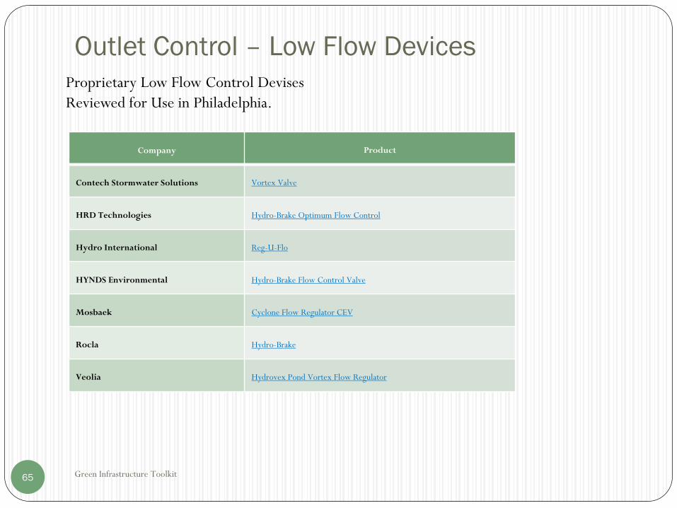
Outlet Control – Low Flow Devices
Green Infrastructure Toolkit65
Company Product
Contech Stormwater Solutions Vortex Valve
HRD Technologies Hydro-Brake Optimum Flow Control
Hydro International Reg-U-Flo
HYNDS Environmental Hydro-Brake Flow Control Valve
Mosbaek Cyclone Flow Regulator CEV
Rocla Hydro-Brake
Veolia Hydrovex Pond Vortex Flow Regulator
Proprietary Low Flow Control Devises
Reviewed for Use in Philadelphia.

Flow Through Practices
Green Infrastructure Toolkit66
Soil based outlet control can be used as an alternative to conventional flow
control devices.
Soil can be placed over an underdrain (see GI practices with underdrains).
The flow rate is a function of the depth of the soil layer and the soil’s permeability.
For example, soil medias used for biorentention areas may have a permeability of
0.5 ft/day to 2 ft/day. The desired rate of outflow can be achieved by selecting the
appropriate soil and soil depth.
Open Channel Systems
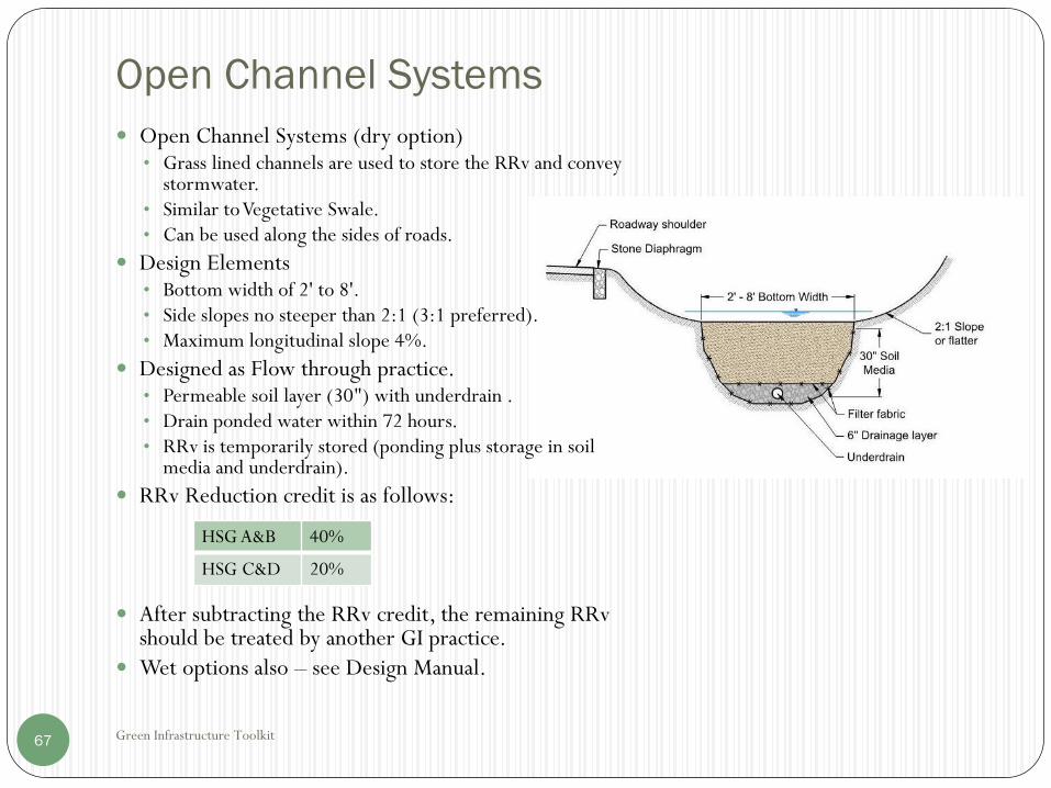
Green Infrastructure Toolkit67
Open Channel Systems (dry option)• Grass lined channels are used to store the RRv and convey
stormwater.• Similar to Vegetative Swale.• Can be used along the sides of roads.
Design Elements• Bottom width of 2' to 8'.• Side slopes no steeper than 2:1 (3:1 preferred).• Maximum longitudinal slope 4%.
Designed as Flow through practice. • Permeable soil layer (30") with underdrain .• Drain ponded water within 72 hours.• RRv is temporarily stored (ponding plus storage in soil
media and underdrain).
RRv Reduction credit is as follows:
After subtracting the RRv credit, the remaining RRv should be treated by another GI practice.
Wet options also – see Design Manual.
HSG A&B 40%
HSG C&D 20%

Planning Tips
Green Infrastructure Toolkit68
Reduce Building Footprint:
• Smaller building
• Additional Stories
Reduce Driveway Pavement
• Narrower widths
• Smaller Turnarounds
• Fewer entrance/exits
Reduce Parking
• Shared Parking
• Smaller Spaces
• Reduced Spaces for Motorcycles & Smaller
Vehicles
Preserve Undisturbed & Sensitive Areas
• Identify and avoid streams, wetlands and wetland
buffers
• Use Compact Site Design
Resources:
• NYSDEC Better Site Design.
• Rhode Island DEM The Urban Environmental
Design Manual.
• Center for Watershed Protection, Better Site
Design.
• Maryland DEP, Low-Impact Development
Design Strategies.

Planning Tips
Green Infrastructure Toolkit69
Graphic Information Systems (GIS) is a great tool for planning and more and more data is becoming available.
For the purposes of site and GI planning, sites of particular interest include:
Source Data Available
Stormwater Coalition of Albany County Watershed Maps
Other GIS Links
Albany County GIS Tax Parcel Data
Orthoimagery
2' elevation contours
FEMA Flood Zones
DEC & NWI Wetlands
Rensselaer County GIS Tax Parcel Data
NYSDEC Environmental Resource Mapper DEC wetlands
Water bodies and classifications
Rare plants/animals
Significant natural Communities
NRCS –Web Soil Survey Soils data including HSG information
NYSDEC Stormwater Interactive Map CSOs
MS4s
303(d) Water Bodies
NYSGIS Clearinghouse Rensselaer County Tax Parcel Data
Elevation data – 1 meter DEM, LIDAR data.
including 10’ elevation data
LIDAR elevation data
Orthoimagery
FEMA Flood Map Service Center FEMA Flood Zones

Planning Guide - GI Banking and Vacant Lots
Green Infrastructure Toolkit70
The APC has completed a Feasibility Study for a Green Infrastructure Banking System.
Implementation of this program would provide alternatives for difficult sites that are unable to meet stormwater management requirements.
As part of this effort, CDRPC has identified many vacant lots within the APC.
The Albany County Land Bank Corp., and the Troy Community Land Bank, acquire vacant, abandon and tax foreclosed lots and sells them to eligible buyers.
Vacant lots present a great opportunity to implement GI practices that can be incorporated into a GI banking program.
From a stormwater management perspective, particularly in CSO areas, redevelopment of vacant lots should:
Encourage uses that maximize pervious surfaces such as pocket parks and community gardens.
Minimize impervious surfaces. Porous pavement options should be used where feasible for redeveloping vacant lots for parking.

Planning Guide - GI Banking and Vacant Lots
Green Infrastructure Toolkit71
Resources for GI on Vacant Lots:
Ideas for Vacant Land Re-use in Cleveland, Cleveland City Planning Commission.
Urban Vacant Land Assessment Protocol, 2014 EPA GI Technical Assistance
Program, Buffalo Sewer Authority.
Green pattern Book, Using Vacant Land to Create Greener Neighborhoods in
Baltimore, US Forest Service.
The Greening of Detroit Vacant Land Treatment Guide 2.0, City of Detroit.
Greening Vacant Lots: Planning and Implementation Strategies, the nature
Conservancy NatLab Collaboration

Pretreatment Guide
Green Infrastructure Toolkit72
All GI practices should be protected at the inlet from erosive flows. This may include:• Drops at curb inlets (6" typical)• Stone diaphragms or level spreaders along areas of sheet drainage• Splash pads• Stone check dams• Mulch helps with erosion control and trapping debris in bioretention and
other vegetative practices.• Sample drawings are available (see references) for additional
pretreatment and inlet options.
Catch basin or inlet structures with deep sumps (2') and outlet protection are a low cost “minimum” measure. The outlet can include a sanitary tee or “snout” to reduce downstream migration of “floatables”. Screen outlets limit carry over of larger debris. For combined sewers, use of products such as Tideflex® check valves can prevent odors and sewer backflows.
Catch basins should be periodically inspected and sediment removed to ensure that flow is not blocked.
Pretreatment Guide
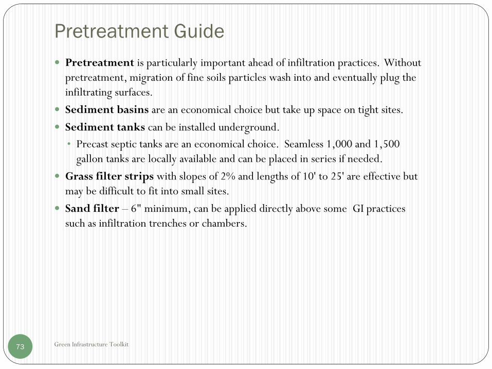
Green Infrastructure Toolkit73
Pretreatment is particularly important ahead of infiltration practices. Without
pretreatment, migration of fine soils particles wash into and eventually plug the
infiltrating surfaces.
Sediment basins are an economical choice but take up space on tight sites.
Sediment tanks can be installed underground.
• Precast septic tanks are an economical choice. Seamless 1,000 and 1,500
gallon tanks are locally available and can be placed in series if needed.
Grass filter strips with slopes of 2% and lengths of 10' to 25' are effective but
may be difficult to fit into small sites.
Sand filter – 6" minimum, can be applied directly above some GI practices
such as infiltration trenches or chambers.

Pretreatment Guide
Green Infrastructure Toolkit74
Flow Diversion Structures
Often it is necessary to divert runoff from larger storm events so that these flows bypass GI practices.
• A typical flow diversion structure is contained in a catch basin or manhole.
• Weirs can be used to split the flows. Low flows are directed to GI practices. Larger flows cause water to spill over the weir and discharge to the high flow outlet.
Proprietary pretreatment devices – manufactured products, typically installed in a catch basin or manhole. See list of New Jersey Verified Products at http://www.nj.gov/dep/stormwater/treatment.html
• May be more costly and require more maintenance than passive measures, but can save space and improve sediment and pollutant removal rates.

Soils and Infiltration Testing
Green Infrastructure Toolkit75
Consult NRCS Soils Maps (Web Soil Survey) which show the hydraulic soils groups (HSG)for the site.
HSG Infiltration Rates
inches/hour (1)
Notes
A >1.42 Best for Infiltration
B >.57 ≤ 5.67 Generally ok
C >.06 ≤ 1.42 May be ok
D <0.14 Generally not suitable
• HSG not available for many urban areas (soils classified Ur – Urban soils).
• Infiltration testing required to verify mapping: See Design Manual Appendix D.
• Provide a minimum of 2' to bedrock or seasonal high groundwater unless greater
separation required by local regulators.
• Soil restoration is important for previously disturbed areas. Till soils to depth of
12". See Design Manual 5.1.6.
(1) NRCS Part 730 national Engineering Handbook, table 7-1.

Planting Guide
Green Infrastructure Toolkit76
Guide
• Select plants to handle the anticipated ponding level and frequency of flooding.
• Select local natural species suitable for Plant Hardiness Zone 5b.
• Avoid invasive species and poisonous plants.
• Maintain a mulch layer for moisture retention and soil fertility.
• Water and weed to maintain a healthy cover of plants.
• Replace with new plants as needed to avoid bare spots.
Resources
• Green Stormwater Infrastructure Landscape Design Guidebook, City of
Philadelphia.
• Design Manual, Appendix H, Landscape Guidance/Plant List.
• Plant Materials for Vegetation Management along New York State Roadsides,
Cornell Cooperative Extension.

Bioretention Soils Guide
Green Infrastructure Toolkit77
• Local organic soils and compost is available from the Albany Recycles Compost Facility
and other local landscaping supply businesses.
Resources
• University of New Hampshire Bioretention Soil Specification
https://www.unh.edu/unhsc/sites/default/files/media/unhsc_bsm_spec_10-3-16.pdf
• Design Manual, Appendix H.

Underdrain Guide
Green Infrastructure Toolkit78
Geotextile – used to separate materials and keep fines from moving into openings of courser materials. Typically a non-woven polypropylene geotextile is used for this purpose.
Stone envelope – surrounds the underdrain pipe. Provides additional storage of stormwater in the open spaces between the stones. The stone or gravel material should be fairly uniform in size to provide open spaces for drainage and washed or screened to minimize excessive fine materials. NYSDOT specifications are commonly used. A good specification for drainage stone is a 50%/50% mix of NYSDOT No. 1 and 2 stone (approximately ¼" to 1" in size).
The Stone should surround the underdrain pipe. Typically 2" below and 4"minimum above the pipe.
Underdrain Pipe
• Typically PVC or Corrugated Polyethylene Pipe (CPP).
• Perforated or slotted.
• Typical sizes uses for underdrain applications – 4" diameter to 8" diameter. Larger diameter pipe is less prone to freezing.
• Cleanouts recommended to allow flushing and cleaning of underdrains.
Cost of GI Practices
Green Infrastructure Toolkit79
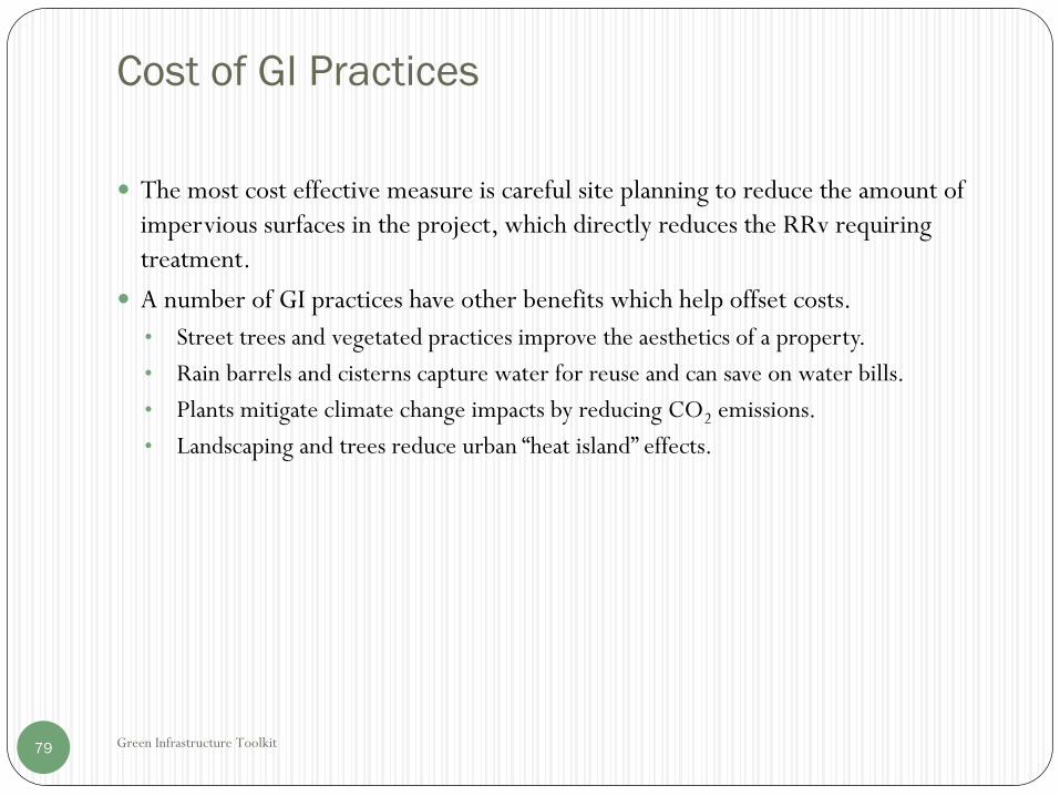
The most cost effective measure is careful site planning to reduce the amount of
impervious surfaces in the project, which directly reduces the RRv requiring
treatment.
A number of GI practices have other benefits which help offset costs.
• Street trees and vegetated practices improve the aesthetics of a property.
• Rain barrels and cisterns capture water for reuse and can save on water bills.
• Plants mitigate climate change impacts by reducing CO2 emissions.
• Landscaping and trees reduce urban “heat island” effects.

Cost of Selected GI Practices
Green Infrastructure Toolkit80
f
GI Practice Range - $/treated ft3
Rain Gardens $3-$6
Stormwater Planters $21-$41
Bioretention Areas $9-$46
Infiltration Trench/Drywell $12-$15
Permeable Pavers $109-$164
Rain Barrels $7-$28
Cisterns $14-$26
From: Water Environment Federation (WEF), Green Infrastructure
Implementation, 2014. Costs in 2012 dollars.

Construction Considerations
Green Infrastructure Toolkit81
Develop and implement an erosion and sediment control plan to protect
downstream properties and waterways.
Proper construction sequencing is critical to make sure the site is stabilized prior
to exposing infiltration areas to sediments that can clog these areas.
Keep heavy equipment off of pervious areas to avoid over compaction.
Restore Soils in pervious areas –Till to 12" depth See: Soils and Infiltration
Testing.

Maintenance Considerations
Green Infrastructure Toolkit82
General
• Check for erosion.
• Integrity of structures and pipes.
• Flows maintained as intended, soil/infiltration not clogging.
Pretreatment
• Remove debris and accumulated sediments.
Vegetation
• Water & fertilizer.
• Weed.
• Replant as needed.
Rain barrels and cisterns
• Need active management to make sure vessel is emptied in advance of storm events.
Proprietary systems
• Generally higher maintenance.
• May include mechanical components.
• Consult manufacturer’s O&M manuals.

Maintenance Considerations
Green Infrastructure Toolkit83
Resources:
A good resource for maintenance is the NYSDEC document, Maintenance Guidance for
Stormwater Practices, September 2016 (draft):
http://www.dec.ny.gov/docs/water_pdf/smpmaintguiddraft.pdf
Sample Maintenance Agreements
City of Syracuse:
http://www.syrgov.net/uploadedFiles/Departments/Engineering/Content/revised%20model%20maintenan
ce%20agreement%207-15-09.doc
NYSDEC:
ftp://ftp.dec.state.ny.us/dow/stormdocuments/Maintenance/Example%20Maintenance%20Agreement.pdf
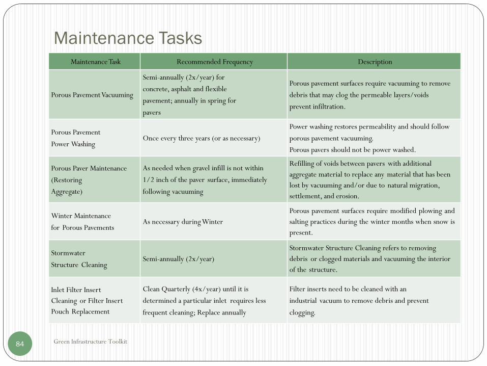
Maintenance Tasks
Green Infrastructure Toolkit84
MaintenanceTask Recommended Frequency Description
Porous PavementVacuuming
Semi-annually (2x/year) for
concrete, asphalt and flexible
pavement; annually in spring for
pavers
Porous pavement surfaces require vacuuming to remove
debris that may clog the permeable layers/voids
prevent infiltration.
Porous Pavement
Power WashingOnce every three years (or as necessary)
Power washing restores permeability and should follow
porous pavement vacuuming.
Porous pavers should not be power washed.
Porous Paver Maintenance
(Restoring
Aggregate)
As needed when gravel infill is not within
1/2 inch of the paver surface, immediately
following vacuuming
Refilling of voids between pavers with additional
aggregate material to replace any material that has been
lost by vacuuming and/or due to natural migration,
settlement, and erosion.
Winter Maintenance
for Porous PavementsAs necessary during Winter
Porous pavement surfaces require modified plowing and
salting practices during the winter months when snow is
present.
Stormwater
Structure CleaningSemi-annually (2x/year)
Stormwater Structure Cleaning refers to removing
debris or clogged materials and vacuuming the interior
of the structure.
Inlet Filter Insert
Cleaning or Filter Insert
Pouch Replacement
Clean Quarterly (4x/year) until it is
determined a particular inlet requires less
frequent cleaning; Replace annually
Filter inserts need to be cleaned with an
industrial vacuum to remove debris and prevent
clogging.
Maintenance Tasks - Continued
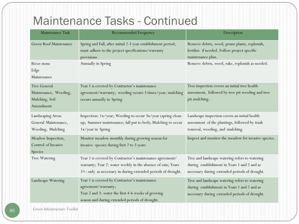
Green Infrastructure Toolkit85
Maintenance Task Recommended Frequency Description
Green Roof Maintenance Spring and Fall, after initial 2-3 year establishment period;
must adhere to the project specifications/warranty
provisions
Remove debris, weed, prune plants, replenish,
fertilize if needed. Follow project specific
maintenance plan.
River-stone
Edge
Maintenance
Annually in Spring Remove debris, weed, rake, replenish as needed.
Tree General
Maintenance, Weeding,
Mulching, Soil
Amendment
Year 1 is covered by Contractor’s maintenance
agreement/warranty; weeding occurs 3 times/year; mulching
occurs annually in Spring
Tree inspection covers an initial tree health
assessment, followed by tree pit weeding and tree
pit mulching.
Landscaping Areas
General Maintenance,
Weeding, Mulching
Inspection: 1x/year; Weeding to occur 3x/year (spring clean-
up; Summer maintenance; fall put to bed); Mulching to occur
1x/year in Spring
Landscape inspection covers an initial health
assessment of the plantings, followed by trash
removal, weeding, and mulching.
Meadow Inspection,
Control of Invasive
Species
Monitor meadow monthly during growing season for
invasive species during first 2 to 3 years
Inspect and monitor the meadow for invasive species.
Tree Watering Year 1 is covered by Contractor’s maintenance agreement/
warranty; Year 2: water weekly in the absence of rain; Years
3+: only as necessary in during extended periods of drought.
Tree and landscape watering refers to watering
during establishment in Years 1 and 2 and as
necessary during extended periods of drought.
Landscape Watering Year 1 is covered by Contractor’s maintenance
agreement/warranty;
Year 2 and 3: water the first 4-6 weeks of growing
season and during extended periods of drought.
Tree and landscape watering refers to watering
during establishment in Years 1 and 2 and as
necessary during extended periods of drought.

Maintenance Tasks - Continued
Green Infrastructure Toolkit86
MaintenanceTask Recommended Frequency Description
Tree Pruning Year 1 is covered by Contractor’s maintenance
agreement/warranty;
One-time per year in Year 3 (Fall or Spring depending on
species); One time per year in years 5, 8, 12, 18, 24, 30,
36, 44, 52, 60
Tree and landscape pruning refers to annual
pruning to maintain aesthetics and promote tree
vigor.
Landscape Pruning Year 1 is covered by Contractor’s maintenance
agreement/warranty; 1x/year beginning in Year 2
depending on plant type
Tree and landscape pruning refers to annual
pruning to maintain aesthetics and promote tree
vigor.
Meadow Mowing Year 1: once a month from Apr-Nov;Year 2: Once in Fall;
Year 3 and beyond: once every 2 years in Spring
Mowing helps prevent/control woody plant and
weed establishment, and helps to disperse seeds
of desirable species.
Landscape
Replacement
(excludesTrees)
Spring and Fall, as a corrective maintenance task that
should only be performed on an as needed basis
Replace missing, dead, or diseased
shrubs and herbaceous plant material.

Maintenance Costs
Green Infrastructure Toolkit87
Maintenance Cost Estimates vary widely, and because systematic GI use is relatively new there are limited
records of existing programs. Below is an estimate of maintenance costs for a recent Green Infrastructure
Project.
GI TYPE REQUIRED MAINTENANCE FREQUENCY ESTIMATED
ANNUAL COST ($)
Porous pavements Vacuuming of surface
Inspection & Cleaning of drainage structures
2 times per year Avg. $0.15 / SF
Rain Gardens Water & Care Establishment Weeding, Pruning,
Mulching Inspect & Clean overflow drainage
Remove litter, debris, sedimentation
4 times per year (Spring & Fall
critical)
Avg. $0.30 / SF
Bioretention Water & Care Establishment Weeding, Pruning,
Mulching Inspect & Clean overflow drainage
Remove litter, debris, sedimentation Erosion Control,
stone apron repairs
3 times per year (Spring & Fall
critical)
Avg. $0.75 / SF

Lessons Learned
Green Infrastructure Toolkit88
Many GI projects are highly specialized and may require deviations from standard
construction best practices. GI has a unique set of best practices which are evolving
quickly. Additional communication between contractors, municipal staff, and designers
can help resolve these differences and build unified project goals.
Key communication and inspections should occur during the following construction
activities:
• Erosion and sediment controls - proper installation practices, down gradient
perimeter control, checklist conformity.
• Excavation, grading and site preparations – critical staging and phasing of operations,
identify infiltration areas, keep water/storage clean and protected, identify
stabilization areas, limit compaction as necessary.
• Utility installation and protection – identify utilities to remain and protection
measures required, may require careful vacuum excavation to limit disturbances,
ensure anti-seepage collars are installed where required, coordination with owners of
utilities.

Lessons Learned - Continued
Green Infrastructure Toolkit89
• Stormwater infrastructure – services kept off line until surface measures in place,
proprietary devices functioning and properly installed, elevations are verified for
structures and piping inverts.
• Pavement installation – inspections to ensure proper compaction, subbase and storage
depths; limit debris and sediment; observe construction traffic, compaction, and
protection; direct stormwater to temporary stabilized areas if necessary.
• Finish grading – attention to detail, proper elevations of pavements, curbs, structures,
slopes, low points, etc; communicate proper adjustments if necessary; appropriate soil
amendments, tilling, decompaction and permeability testing if needed; installation of
rock areas, diaphragms, and outlet/ inlet elements.
• Vegetation – proper planting techniques, locations, depths, procedures; ensure
adequate water and moisture retention for establishment; inspect for disease, dying or
decaying materials; ensure proper placement and type for function of plantings.
Green Infrastructure Toolkit90
Local GI Projects

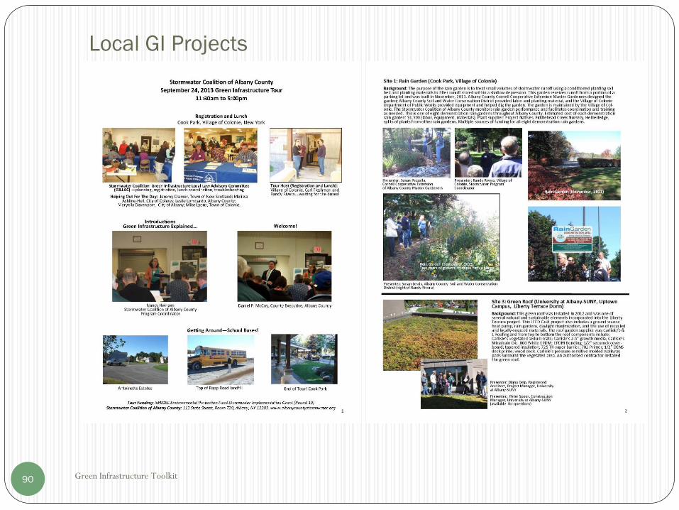
Green Infrastructure Toolkit91
Local GI Projects

Green Infrastructure Model Local Law Project92
General References that include extensive stormwatertools and resources:
US Environmental Protection Agency (USEPA)
University of New Hampshire Stormwater Center
The Center for Watershed Protection
Low Impact Development Center
The Water Environment Federation
National Association of City Transportation Officials, Urban Street Stormwater Guide.
New York State Department of Environmental Conservation (NYSDEC)
Stormwater Management Design Manual
NYS Standards and Specifications for Erosion and Sediment Control (Blue Book)
Better Site Design
New York City
Guidelines for the Design and Construction of Stormwater Management Systems
NYC Green Infrastructure Plan (Includes GI cost estimates)
NYC Standards for Green Infrastructure (Includes CAD drawings)
City of Chicago
Stormwater Management Ordinance Manual
Green Alley Handbook
City of Philadelphia
Stormwater management Guidance Manual
Green Street Design Manual
Green Streets Details (CAD drawings)
Green Stormwater Infrastructure Standard Details (CAD Drawings)
Green Stormwater Infrastructure Planning & Design Manual
Green Stormwater Infrastructure Landscape Design Guidebook
City of Portland
Stormwater Management Manual
Presumptive Performance Details (CAD drawings)
Stormwater Simplified Typical Details (CAD drawings)
Green Street Typical Details (CAD drawings)
City of Rochester and Monroe County
Green Infrastructure Retrofit Manual
Additional References

Glossary
Green Infrastructure Toolkit93
• Aic – Area of directly connected impervious cover
• APC – Albany Pool Communities
• CDRPC – Capital District Regional Planning Commission
• cfs – cubic feet per second
• Design Manual – New York State Stormwater Design Manual, NYSDEC
• GI – Green Infrastructure
• HSG – NRCS Hydrologic Soil Group
• NYSDEC – New York State Department of Environmental Conservation
• NRCS – National Resource Conservation Service
• RRv - Runoff Reduction Volume –The volume of runoff to be treated by Green Infrastructure practices, equal to 1” of rainfall over the area of impervious surfaces.
• WQv –Water Quality Volume –The volume of stormwater to be treated under the Design Manual, equal to the runoff from the 24 hour 90% storm event. Differs from the RRv because it is calculated on the total contributing area, which can include both impervious and pervious areas.
Recommended