Bureau of Mines Report of Investigations/l979
Geology of the Lower Kittanning Coalbed and Related Mining and Methane Emission Problems in Cambria County, Pa.
UNITED STATES DEPARTMENT OF THE INTERIOR

Report of Investigations 8354
Geology of the Lower Kittanning Coalbed and Related Mining and Methane Emission Problems in Cambria County, Pa.
By A. T. Iannacchione and D. G. Puglio
UNITED STATES DEPARTMENT OF THE INTERIOR Cecil D. Andrus, Secretary
BUREAU OF MINES Roger A. Markle, Director

CONTENTS Page
Abstract ................................................................ ............................................................ Introduction Acknowledgments ......................................................... . ........................................................ Regional geology Geology of the Lower Kittanning coalbed ................................. ....................................................... Strat igraphy
Structure .......................................................... Mining problems re la ted t o geology of the Lower Kittanning coalbed ......
Occurrence of 'bants" .............................................. Types of unstable roof .............................................
Methane emission ........................................................ Summary and conclusions ................................................. References ..............................................................
ILLUSTRATIONS
Location of study area ............................................. Location of important geographic fea tures of northern Cambria ....................................................... County. Pa .......... Physiographic d iv is ions i n the area around Canibria County Generalized s t r a t i g r a p h i c column of exposed rocks i n the Allegheny
Mountain sec t ion of Appalachian Plateau Pruvince ................. Generalized s t r a t i g r a p h i c column of the Kittanning Formation ....... Clay par t ing i n the Lower Kittanning coalbed ....................... Panel diagram of the i n t e r v a l from the bottom of the Lower
Kittanning coalbed t o the top of the Upper Kittanning coalbed .... Percent sandstone map of the i n t e r v a l from the top of the Lower
Kittanning coalbed t o the bottom of the Middle Kittanning coal group .......................................................
Isopach map of the i n t e r v a l from the top of the Lower Kittanning coalbed t o the bottom of the Middle Kittanning coa l group ........
Structure contours on the base of the Lower Kittanning coalbed ..... Location and cross-sect ional view of three displacement f a u l t s
encountered i n the Barnes and Tucker No . 20 mine ................. Rose diagrams of bedrock jo in t s of each of the nine quadrangles ................................................ of the study area Rose diagrams of c l e a t or ienta t ions i n e igh t of the nine ......................................... 7-112-minute quadrangles Mined-out-area map of mines i n the Lower Kittanning coalbed.
showing "want" areas ............................................. ..................... Isopach map of the Lower Worthington Sandstone Map showing the cor re la t ion of the th ick Lower Worthington Sand- ............... stone with "wants" i n the Lower Kittanning coalbed Isopach map of the Lower Kittanning coalbed ........................ St ra t ig raph ic sec t ions o f t h e Lower Kittanning coal group and
locat ion of cross sec t ions ....................................... .......... St ra t ig raph ic sec t ions of the Lower Kittanning coa l group

ILLUSTRATIONS --C ontinued Page
20. Generalized cross sec t ion of c h a r a c t e r i s t i c unstable roof asso- c ia ted with sandstone channels................................... 21
21, Map showing the h igh-roof- ins tabi l i ty areas r e l a t e d t o the s t r a t i g r a p h i c pos i t ion of the Lower Worthington Sandstone and the Middle Kittanning coalbed............................,....... 22
22. Generalized cross sec t ion of c h a r a c t e r i s t i c unstable roof asso- c i a t e d with thinning of the i n t e r v a l between t h e top of the Lower Kittanning coalbed and the bottom of t h e Middle Kittanning c o a l b e d . . . . . . . . . . . . . . . . . . . . . . . . . . . . . . . . . . . . . . . . . . . . . . . . . . . . . . 23
23. "Cutter" occurring p a r a l l e l t o the r i b ............................. 25 24. Isopach map of the overburden above the Luwer Kit tanning coalbed... 26
TABLE
1. Average methane emissions during coal production and depth of s i x ac t ive deep mines i n Lawer Kittanning coalbed.................... 27

GEOLOGY OF TtIE LOWER KITTANNING COALBED AND RELATED hilNlNG AND METHANE EMISSION PROBLEMS
IN CAMBRIA COUNTY, PA.
A. T. lannacchione 1 and D. G. Pugl io 1
ABSTRACT
The Bureau of Mines es tabl i shed geologic f ac to r s a f f e c t i n g the mining of the Lower Kittanning coalbed t o a id i n coalbed minabi l i ty s tud ies and examined the occurrence of "wants" (places where coal i s missing) and types of unstable roof rock s t r a t a . Trends es tabl i shed from mapping, including p red ic t ion of areas of high methane emissions, were ext rapola ted t o unmined a reas .
'Vants" i n the coalbed a r e of two types: Erosional and deposi t ional . Erosional f ea tu res occur where north-south-trending sand-f i l led channels cut i n t o the coalbed. Variat ions i n deposi t ional environments have caused the coalbed t o " s p l i t " i n t o severa l th inner u n i t s .
S l ickens ides , commonly ind ica t ive of unstable r o o f , a r e adjacent t o and on the underside of sandstone channels; they were caused by d i f f e r e n t i a l c&- pact ion and by s o f t sediment s l i d i n g along the contact between the sandstone and adjacent sha le . The frequency of unstable roof a l s o increases where the i n t e r v a l between the Middle and Lower Kit tanning coalbed is l e s s than 30 f e e t . The zones of weakness a t the contacts above and below the Middle Kittanning coalbed a r e the con t ro l l ing fac to r s f o r unstable roof i n these s t r a t a .
Methane emissions from the coalbed a r e cont ro l led pr imar i ly by depth , f r a c t u r e permeabil i ty, and rank of coal . Local geologic f ac to r s a r e coalbed th ickness , associa ted rock s t r a t a , s t r u c t u r e , and proximity t o outcrop.
INTRODUCTION
The Lower Kittanning coalbed i n Cambria County, Pa., has a long mining h i s t o r y and i s cu r ren t ly being explored t o define deeper reserves . As these deeper reserves a r e explored, geologic f ac to r s t h a t a f f e c t mining i n unmined coa l need t o be examined t o a id i n mine planning. With the accumulation of large amounts of explora t ion d r i l l i n g data over the l a s t century , it i s now possible t o analyze geologic t rends i n a c t i v e l y mined areas and t o p ro jec t these trends i n t o unmined areas. Delineat ion of "want" t rends where the coal
l ~ e o l o g i s t , Pi t tsburgh Mining and Safety Research Center , Bureau of Mines, P i t t sburgh, Pa.

i s missing and p red ic t ion of areas of high roof i n s t a b i l i t y and high methane emissions a r e the main topics of concern i n t h i s Bureau of Mines study. '
Cambria County i s i n west-central Pennsylvania ( f i g . 1 ) . It l i e s near the e a s t e r n edge of the Allegheny Plateau Province and i s near the nor theas tern edge of the Appalachian c o a l f i e l d , which extends from southern New York t o northern Alabama. Major towns , r i v e r s , and the nine 7-1/2-minute topographic quadrangles t h a t make up the study a rea a r e shown i n f igure 2.
I n Cambria County the Lower Kit tanning i s a low- t o medium-volatile b i t u - minous coa l which has been used f o r coke making and steam generat ion. It i s genera l ly very f r i a b l e and ranges i n thickness from 0 t o 117 inches , averaging 36 t o 60 inches. Overburden thickness ranges from zero a t the outcrop t o 1,100 f e e t . Mining i s p resen t ly most ac t ive i n the deepest sync l ines , where most of the remaining reserves l i e under 600 f e e t of overburden.
When the Lower Kit tanning coalbed was f i r s t mined, i t was common prac t i ce t o mine from outcrop i n t o the surrounding h i l l s i d e s , always s taying a b w e drainage. "Wants" and unstable roof were encountered, but methane gas was not the major problem t h a t i t i s today. L i t t l e explora t ion coring was done, and coal was mined u n t i l t h i n c o a l , bad roof , or excessive water problems made i t uneconomical t o continue.
The methane problem increased as deeper coal reserves were mined, and the gas i s now genera l ly considered a major mining hazard of t h i s a rea . I n a recent survey, I r a n i (5J2 compiled a l i s t of the 35 counties i n the United S ta tes with the h ighes t gas emissions from a c t i v e mines. Cambria County ranks n in th (methane emissions to ta l ed 10.3 MMcfd i n 1975) among those count ies . This ranking i s l a rge ly cont ro l led by the Lower Kittanning coalbed because i t accounts f o r the g r e a t e s t amount of tonnage of the four coalbeds p resen t ly being mined i n t h i s county and a l s o because i t i s s t r a t i g r a p h i c a l l y the lowest minable coalbed i n the l o c a l geologic sec t ion .
ACKNOWLEDGMENTS
The authors thank the following companies and t h e i r o f f i c i a l s f o r t h e i r cooperation i n c o l l e c t i n g data : Barnes and Tucker Mining Co., Bethlehem Mining Co. , Eastern Associated Coal Corp. , and Clea r f i e ld Bituminous Coal Co.
The authors a l s o thank Norman K. F l i n t , Department o f Ear th and Planetary Sciences, Universi ty of Pi t t sburgh, P i t t sburgh, Pa. , f o r h i s suggestions regarding prepara t ion of the manuscript.
REGIONAL GEOLOGY
Cambria County l i e s physiographical ly wi th in the A'llegheny Mountains s e c t i o n of the Appalachian Plateau Prwince ( f i g . 3 ) . The Allegheny Front , which forms the border between the Appalachian Plateau Prwince and the Valley
'underlined numbers i n parentheses r e f e r t o items i n the l i s t of references a t the end of t h i s repor t .

/
I--
NEW
YO
RK
--
I
1 PE
NN
SY
LVA
NIA
I
r -y-
I PE
N;+
?LVA
NIA
/
i --
W
ES
T V
IRG
INIA
M
AR
YLA
ND
0
20
-
Scal
e, m
iles
FIG
UR
E 1
. -
Lo
cati
on
of
stud
y ar
ea.
* 7-ID
-min
ute
quad
rang
le n
ames
COUN
TY
I
0
6,0
00
-
Scal
e, f
t
FIG
UR
E 2.
- L
oca
tio
n o
f im
po
rtan
t g
eog
rap
hic
fea
ture
s o
f n
ort
her
n C
amb
ria
Co
un
ty,
Pa.

Pittsburgh n~ P A ~ P I P I n
SOMERSET COUNTY I BEDFORD COUNTY \ 0 10 -
APPALACHIAN PLATEAU VALLEY AND RIDGE Scale, miles PROVINCE PROVINCE
FIGURE 3. - Physiographic divisions in the area around Cambria County.
and Ridge Province, generally coincides with the eas tern border of Cambria County. Directly west of the Allegheny Front, open folds having flank dips of 1 " t o 20" characterize the Allegheny Mountain Province.
Predominantly Pennsylvanian sediments a re exposed i n the Allegheny Moun- t a i n sect ion. A generalized geologic column of exposed rocks i n the Allegheny Mountain sect ion i s shown i n f igure 4 .
The Allegheny Group (the group containing the Lower Kittanning coa lbed) includes a l l rocks from the base of the Brookville coal t o the top of the Upper Freeport coal . The Allegheny Group, comprised o f t h e Clarion, Kittanning, and Freeport Formations, i s composed of sandstone, shale , limestone, c lay stone, and coalbeds (5) .
The loca l geologic s e t t i ng d i r ec t l y r e f l e c t s the regional geology. The s t ra t ig raph ic sect ion of i n t e r e s t i s the Kittanning Formation, which includes the Lower Kittanning coalbed. The formation var ies i n thickness wi thin the area of invest igat ion i n two ways: (1) It shows a regional thinning t o the northwest, and (2) localized channel scour-and-fi l l phenomena have thinned,

thickened, or removed sect ions of the geologic column. The formation has a maximum thickness of 130 f e e t and a minimum thickness of 85 f e e t .
Sy s tern
Pennsylvanian
Mississippian
Devonian
.
Figure 5 i s a generalized s t r a t i - graphic column describing the l i thology from the Lower Kittanning t o the Upper Kittanning coalbed ( the Kittanning Formation) . The more important s t r a t i - graphic markers include the Lower, Middle , and Upper K i t tanning coa lbeds and t h e i r underclays , the Lower and Upper Worthington Sandst one, and the Johnstown Limestone. I n any par t icu- l a r locat ion one or more of the mem- bers may be absent.
Rock unit
Monongahela Group Conemaugh Group Allegheny Group Pottsville Group
Mauch Chunk Formation Loyalhanna Formation Pocono Formation
Catskill Formation Jennings Formation
Recognition of a coalbed i s par- t i a l l y dependent on recognizing key rock u n i t s . The Lower Kittanning coal group i s recognized a s lying between
FIGURE 4. - Generalized stratigraphic col- the Kittanning Sands tone and ,-he wer- umn of exposed rocks in the lying Lower Worthington Sandstone. We Allegheny Mountain section of chose t o r e f e r t o the horizon contain- Appalachian Plateau Province. ing the Lower Kittanning coalbed a s
pa r t of the Lower Kittanning coal group, owing t o the inconsis tent character of the i n t e r v a l . The lower coalbed a s a ru le i s the t h i c k e r , more pe r s i s t en t coal. For t h i s reason l o c a l usage r e f e r s t o the lower coalbed i n the Lower Kittanning coa l group as the Lower Kit tan- ning coalbed, and t o the upper coalbed as the Lower Kittanning "r ider t1 coal .
Another s t r a t i g r a p h i c problem i n t h i s i n t e r v a l i s d is t inguishing the Lower Kittanning "r ider t ' coal from the Middle Kittanning coa l group where the Lower Worthington Sandstone i s missing. The lowest member of the Middle Kittanning coal group has a th ick underclay, whereas the Lower Kittanning "rider" coalbed general ly has none. I n cor re la t ing the Middle Kittanning coal group throughout the a r e a , the f i r s t coalbed above the Lower Kittanning coal- bed with a well-developed underclay is considered the Middle Kittanning. It has been suggested by Spieker (l6) i n h i s s tudies of the Cretaceous of Utah and by Weller (20) i n h i s s tudies of the Pennsylvanian of I l l i n o i s t h a t coal- beds r e p r e s e n t i z a regression of the sea have sharp lower contacts of sand- stone, s i l t s t o n e , or sha le , whereas t ransgress ion of the sea produces varying thickness of claystone beneath a coal .
Local s t ruc tu res include fo lds , f a u l t s , j o i n t s , and c l e a t s i n the coal . The fo lds , j o i n t s , and c l e a t s general ly appear t o have a genet ic r e la t ionsh ip with the Allegheny Front , based on the f a c t t h a t the fo ld axes , nonsystematic j o i n t s , and b u t t c l e a t s a r e p a r a l l e l t o the trend of the Allegheny Front , while the systematic jo in t s and face c l e a t s a r e perpendicular t o it.
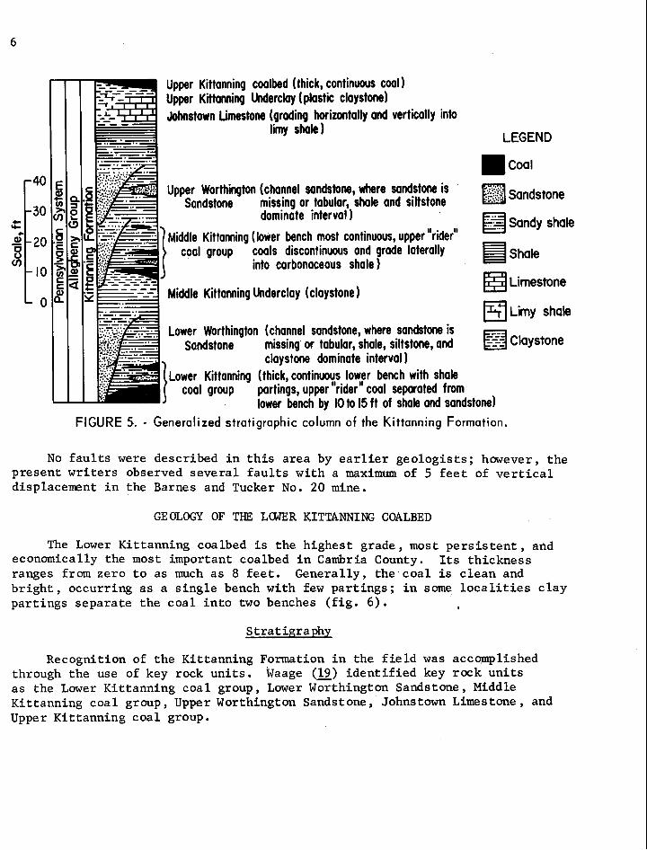
Upper Kittanning coalbed (thick, continuous coal) Upper Kittanning Underclay (plastic claystone) Johnstown Limestone (grading horizontally and vertically into
limy shale 1 LEGEND
coa l
Upper Worthington (channel sandstone, where sandstone is ..: ::.:!:! ::... Sandstone missing or tabular, shale and siltstone Sandstone
dominate interval ) Sandy shale
Middle Kittanning (lower bench most continuous, upper "rider" coal group coals discontinuous and grade laterally
into carbonaceous shale 1 Shale
Middle Kittanning Underclay (claystone) Limestone
Limy shale Lower Worthington (channel sandstone, where sandstone is
Sandstone missing or tabular, shale, siltstone, and claystone claystone dominate interval
Lower Kittanning (thick, continuoy: lobvfr bench with shale coal group partings, upper rider coal separated from
lower bench by 10 to 15 f t of shale ond sandstone) FIGURE 5. - Generalized stratigraphic column of the Kittanning Formation.
No f a u l t s were described i n t h i s area by e a r l i e r geologis ts ; however, the present w r i t e r s observed severa l f a u l t s with a maximum of 5 f e e t of v e r t i c a l displacement i n the Barnes and Tucker No. 20 mine.
GEOLOGY OF THE LOWER KITTANNING COALBED
The Lower Kittanning coalbed i s the highest grade, most p e r s i s t e n t , and economically the most important coalbed i n Cambria County. I t s thickness ranges from zero t o as much a s 8 f e e t . Generally, the coa l i s c lean and b r i g h t , occurring as a s i n g l e bench with few par t ings ; i n some l o c a l i t i e s c l a y par t ings separa te the coal i n t o two benches ( f i g . 6) . I
Strat igraphy
Recognition of the Kittanning Formation i n the f i e l d was accomplished through the use of key rock un i t s . ~ a a g e (2) i d e n t i f i e d key rock u n i t s a s the Lower Kittanning coal group, Lower Worthington Sandstone, Middle Kittanning coal group, Upper Worthington Sandstone, Johnstown Limestone, and Upper Kit tanning coal group.

FIGURE 6. - Clay por t ing in she Lower Kit tanning coolbed.
Figure 7 is a panel diagram showing a three-dimensional v i e w of Litho- logic facies in the Kittanning Formation. Several key rock u n i t s are recog- nized i n every section; however, no one section conta ins al l . key units i d e n t i f i e d by Waage ( 1 9 ) . -
The Lower Kittanning coalbed is very pers i s ten t ( f i g . 7 ) even though it may be split by as many as three v i s ib l e part ings . InnnedFateZy belcrw the L o w e r Kittanning coalbed and overlying the Kit tanning Sandstone and shale members of the Clar ion Formation is the Lower Kittanning Underclay.
The s t r a t a immediately overlying the Lower Kittanning coalbed genera l ly c o n s i s t of dark gray and gray s h a l e , some s i l t s t m e , and thin tabular sand- stone. Abundant s i d e r i t e nodules in layers parallel to the bedding occur in the siltstone and shale.

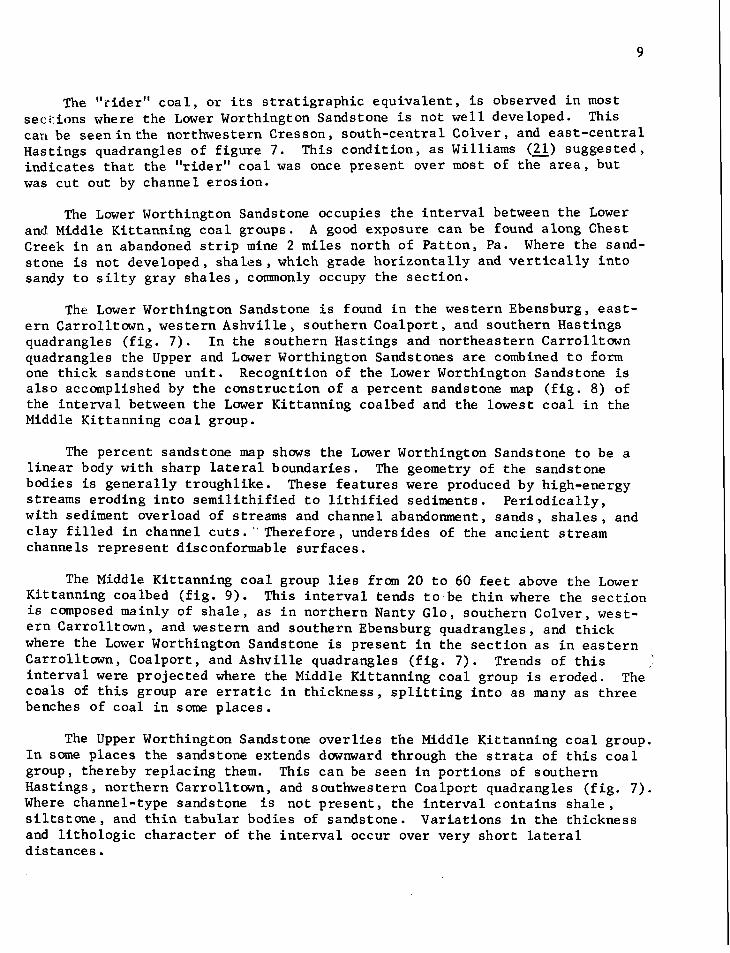
The "-riderf ' c o a l , o r i t s s t r a t i g r a p h i c equ iva l en t , i s observed i n most seci:ions where the Lower Worthington Sandstone i s no t w e l l developed. This car1 be seen i n t he northwestern Cresson, sou th -cen t r a l Colver , and e a s t - c e n t r a l Hastings quadrangles of f i g u r e 7. This cond i t i on , a s Williams (2l) sugges ted , i n d i c a t e s t h a t t he " r ider" c o a l was once p re sen t over most of t h e a r e a , bu t was c u t out by channel e ros ion .
The Lower Worthington Sandstone occupies t h e i n t e r v a l between the Lower and Middle Ki t tanning c o a l groups. A good exposure can be found along Chest Creek i n an abandoned s t r i p mine 2 mi les no r th of Pa t ton , Pa. Where t h e sand- s tone is no t developed, s h a l e s , which grade h o r i z o n t a l l y and v e r t i c a l l y i n t o sandy t o s i l t y gray s h a l e s , commonly occupy the s e c t i o n .
The. Lower Worthington Sandstone i s found i n the western Ebensburg, e a s t - e r n Carro l l town, western Ashv i l l e , southern Coa lpo r t , and southern Hast ings quadrangles ( f i g . 7 ) . I n the southern Hast ings and no r theas t e rn Carrol l town quadrangles the Upper and Lower Worthington Sandstones a r e combined t o form one t h i c k sandstone u n i t . Recognition of t h e Lower Worthington Sandstone i s a l s o accomplished by t h e cons t ruc t ion of a percent sandstone map ( f i g . 8) of the i n t e r v a l between the Lower Kit tanning coalbed and t h e lowest c o a l i n the Middle Ki t tanning c o a l group.
The percent sandstone map shows the Lower Worthington Sandstone t o be a l i n e a r body wi th sharp l a t e r a l boundaries. The geometry of t h e sandstone bodies i s gene ra l ly t roughl ike . These f e a t u r e s were produced by high-energy streams eroding i n t o s e m i l i t h i f i e d t o l i t h i f i e d sediments. P e r i o d i c a l l y , wi th sediment overload of streams and channel abandonment, s ands , s h a l e s , and c l ay f i l l e d i n channel c u t s . " Theref o r e , undersides of t he anc i en t s t ream channe 1s rep resen t disconformable s u r f aces .
The Middle Kit tanning c o a l group l i e s from 20 t o 60 f e e t a b w e t h e Lower Kit tanning coalbed ( f i g . 9 ) . This i n t e r v a l tends t o be t h i n where the s e c t i o n i s composed mainly of s h a l e , a s i n nor thern Nanty Glo, southern Colver , west- e r n C a r r o l l t own, and western and southern Ebensburg quadrangles , and t h i c k where t h e Lower Worthington Sandstone i s present i n t h e s e c t i o n a s i n e a s t e r n Carrol l town, Coalpor t , and Ashvi l le quadrangles ( f i g . 7 ) . Trends of t h i s i n t e r v a l were pro jec ted where t h e Middle Ki t tanning c o a l group i s eroded. The coa l s of t h i s group a r e e r r a t i c i n t h i ckness , s p l i t t i n g i n t o a s many a s t h r e e benches of coa l i n some p l aces .
The Upper Worthington Sandstone o v e r l i e s t h e Middle Ki t tanning c o a l group. I n some p laces t h e sandstone extends downward through the s t r a t a of t h i s c o a l group, thereby rep lac ing them. This can be seen i n po r t ions of southern Has t ings , no r the rn Carrol l town, and southwestern Coalport quadrangles ( f i g . 7 ) . Where channel-type sandstone i s no t p r e s e n t , t he i n t e r v a l conta ins s h a l e , s i l t s t o n e , and t h i n t a b u l a r bodies of sandstone. Var i a t ions i n t h e th ickness and l i t h o l o g i c c h a r a c t e r of t h e i n t e r v a l occur over very s h o r t l a t e r a l d i s t a n c e s .

I I
CLEARFIELD INDIANA COUNTY
COUNTY - - -
I CAMBRIA
LEGEND a 0 to IOpct n 2 5 to 5 0 p c t 0 A 20 000
H l O t o 2 5 p c t m > 5 0 p c t Scale, f t
FIGURE 8. - Percent sandstone map of the interval from the top of tne Lower Kittanning coalbed to the bottom of the hliddle Kittanning coal group.

The Johns town Limestone t y p i c a l l y r e s t s on s h a l e and grades l a t e r a l l y i n t o limy s h a l e . This l imestone has proven t o be ve ry p e r s i s t e n t , being e s p e c i a l l y t h i c k i n t h e southern h a l f of t he s tudy a r e a ( f i g . 7 ) . It i s a dark-gray , f i n e -gra ined , yellowish-weathering, a r g i l - laceous l imestone which breaks wi th a smooth, con- c o i d a l f r a c t u r e . Genera l ly , the l imestone occurs a s a l e n t i c u l a r body; however, it may occur a s nodules w i t h i n t h i c k e r s e c t i o n s of the Upper Ki t tanning Claystone.
The i n t e r v a l above the Johnstown Limestone i s occu- pied by t h e Upper Ki t tanning Underclay, o r t h e Upper Ki t tanning c o a l group, a s i n the no r the rn Ebensburg quad- r ang le ( f i g . 7 ) . This under- c l a y has comnercial va lue a s a r e f r a c t o r y c l a y i n t h e no r theas t e rn Carrol l town quadrangle.
Res t ing on top of t he
LEGEND Upper Ki t tanning Underclay
1 0 t o 2 0 f t m m ] 4 0 t o 5 0 f t 0 2900~ and/or Johnstown Limestone - m 2 0 to 3 o f t m 5 0 to 6 o f t Scale, ft i s t h e Upper Ki t tanning c o a l m 3 0 to 40ft m z 6 0 f t
( f i g . 7 ) . It i s gene ra l ly a t h i c k , continuous c oalbed
FIGURE 9. - lsopach map of the interval from the top of ly ing approximately 110 f e e t the Lower Kittanning coal bed to the bottom above the t o p of the Lower
of the Middle Kittanning coal group. Kit tanning coalbed.
S t ruc tu re
The most pronounced f o l d i n the a r e a ( f i g . 10) i s t he Ni t tany a r c h , t h e northwest limb of which c ros ses the sou theas t e rn corner of t he s tudy a rea i n B l a i r and Cambria Counties. The northwestern limb of t h i s a r c h forms a cues t a - l i k e f e a t u r e which has been named the Allegheny Front . Ten mi les t o t h e west of t h i s s t r u c t u r e l i e s t h e Laurel H i l l a n t i c l i n e . This f o l d plunges t o t h e no r theas t and i s f lanked t o t he e a s t by t h e Ebensburg a n t i c l i n e and the west by the Nolo a n t i c l i n e . The narrow Bradley and Wilmore syncl ines l i e e n e c h e l o n t o one another between the Laurel H i l l a n t i c l i n e and t h e Allegheny Front . The

LEG
END
O
d
/ S
truct
ure
cont
our,
1W
t in
terv
al
Scal
e, f
t
FIG
UR
E 10
. - S
tru
ctu
re c
on
tou
rs o
n th
e b
ase
of
the
Lo
wer
Ki t
tan
nin
g c
oal
bed
.
Sec
tion
A-A
'-
Str
ike
and
dip
of
faul
t E
-W,
30°
S Fo
ult does
not
cut
into
Sec
tion
B-B
f- S
trik
e an
d di
p of
fa
ult
N 77
O W
, 40
0 NE
S
ectio
n C
-c'-
S
trik
e an
d di
p of
fa
ult
N 4
0'
E,
70°
SE
Loca
tion
of
cros
s se
ctio
ns in
mine
FIG
UR
E 11
. -
Lo
cati
on
an
d
cro
ss-s
ecti
on
al v
iew
o
f th
ree
dis
pla
cem
ent f
ault
s en
cou
nte
red
-in
the
Bar
nes
an
d T
uck
er N
o.
20 m
ine.

spoon-shaped Johnstawn syncline plunges t o the southwest i n the southwestern por t ion of the a r e a , while the broader Barnesboro syncline p a r a l l e l s the west- e r n boundary of Cambria County.
The s t ruc tu re map shows d i s t i n c t i v e changes i n the fo ld along a northwest- southeast b e l t from the southeast corner t o the northwest corner of the study area . Generally, g rea te r amplitudes and c lose r spacing of fo lds occur t o the south of t h i s diagonal. A s t r u c t u r a l culmination along the Barnesboro syn- c l ine and a saddle i n the Laurel H i l l a n t i c l i n e occur along t h i s b e l t . The Johnstown syncline and Ebensburg a n t i c l i n e d i e out d i r e c t l y t o the south of the b e l t , and the Wilmore and Bradley synclines occur en echelon d i r e c t l y along the b e l t . F ina l ly , the amplitude of the Nittany arch increases t o the southwest. Perhaps the d i f f e r i n g degrees of compressional forces exerted on e i t h e r s ide of t h i s b e l t a r e associated with a deep s t r i k e - s l i p f a u l t , a byproduct of the bending i n the Allegheny Front i n c e n t r a l Pennsylvania.
No major f a u l t i n g was recognized i n the study a r e a , but severa l minor d i s - placement f a u l t s i n the Barnes and Tucker No. 20 m i n e ( f ig . 11) were observed along the e a s t e r n f lank of the Laurel H i l l a n t i c l i n e . Upon f i r s t observation, the f a u l t s appeared t o be interconnected and of t ec ton ic o r i g i n , based on t h e presence of highly polished, s l ickensided f a u l t planes, but c lose r observation shows the i n i t i a l observation t o be i n e r r o r . F i r s t , the s t r i k e and d i p of a l l three f a u l t s a r e d i f f e r e n t (EW 30' S , N 77' W , 40" NE, and N 40" SE). Second, the f a u l t plane f l a t t e n s out d i r e c t l y i n t o the bedding plane above the coalbed (c-c', f i g . 11). F ina l ly , the bedding shows reverse drag along t h e f a u l t plane (B-B' , f i g . 11). A l l of these fea tures probably r e s u l t from s o f t - sediment slumping and a re not necessar i ly due t o t e c t o n i c forces. Williams (22) described s imi la r fea tures i n the i n t e r v a l a b w e the Lower Kittanning coalbed i n Clearf ie ld County. He re fe r red t o them a s r o t a t i o n a l slumps, ind ica t ing t h a t t h e i r o r i g i n i s connected with slumping of semi l i th i f i ed blocks of sedi - ment i n t o paleotopographic low areas.
J o i n t d i rec t ions measured i n mine roofs , s t r i p mine highwalls , and wide- spread outcrops within each of the nine quadrangles were p lo t t ed on rose d ia- grams and a re i l l u s t r a t e d i n f igure 12. J o i n t t r aces a r e widely spaced and show many inconsis tent or ienta t ions .
Cleat measurements were taken i n deep mines, i n s t r i p mines, and a t d i f f e r e n t coal outcrops ( f ig . 13) , using the method devised by Diamond (3). The mean face c l e a t , the p r inc ipa l c l e a t perpendicular t o s t r u c t u r a l t r ends , ranges i n d i r e c t i o n from N 8Z0 W t o N 54O W . Mean b u t t c l e a t d i rec t ions range from N 10' E t o N 45' E and p a r a l l e l the s t r u c t u r a l trends i n the area. The face c l e a t s were probably formed as extension f rac tu res during s t r u c t u r a l deformation, and the b u t t c l e a t s a s released f rac tu res during eros ion and u p l i f t (14). -

LI-'
'4
'-I-'
2 m
easu
rem
ents
1 2 m
easu
rem
ents
1 2 m
easu
rem
ents
I
2 m
easu
rem
ents
4 m
eas'u
rem
ents
2 m
easz
emen
ts
BA
RN
ESB
OR
O
1 17
read
ings
CO
LVER
C
AR
RO
LLTO
WN
A
SH
VIL
LE
95 re
ading
s 162
read
ings
70 re
ading
s
4 m
easu
rem
ents + I
HA
STI
NG
S
37 re
ading
s 8 m
easu
rem
ents
+I
CO
ALP
OR
T
I I I r
eadin
gs
4 m
easu
rem
ents -1
I N
AN
TY
GLO
I
EBEN
SBU
RG
1
CR
ES
SO
N
I 1 20
3 re
ading
s 1 55
0 re
ading
s 138
read
ings
016,000
Sca
le,
fT
No
read
ings
I B
AR
NES
BO
RO
I
HA
STIN
GS
I C
OA
LPO
RT
I B
utt
205
W
read
ings
m
easu
rem
ents
525
I re
ading
s m
eaG
iemen
ts 1
W
59
4 re
ading
s m
easu
rem
ents
CO
LVER
C
AR
RO
LLTO
WN
1
AS
HV
ILLE
1
I . .
I - ~l
tt
cl
eat
I Fa
ce c
leat
Face
cle
at
'650
I
E
82O
44
87
W
20
read
ings
mea
sure
men
ts 10
3 A
re
ading
s m
easu
kmen
ts
But
t cl
eat
W 108
4
I read
ings
mea
sure
mts
NA
NTY
G
LO
EBEN
SBU
RG
I
CR
ES
SO
N
Sca
le,
ft
FIG
UR
E 1
2. -
Ro
se d
iag
ram
s o
f b
ed
rock
io
ints
of
ea
ch o
f F
IGU
RE
13.
- R
ose
dia
gra
rrs
of
cle
at
ori
en
tati
on
s in
eig
ht
the
nin
e q
ua
dra
ng
les
of
the
stu
dy
area
. o
f th
e n
ine
7-l
/2-m
inu
te
quad
rang
les.

M I N I N G PROBLEMS RELATED TO GEOLOGY OF THE LOWER KITTANNING COALBED
Cer ta in geologic f ac to r s con t ro l the condit ions t h a t lead t o problems i n mining the Lower Kit tanning coalbed. These f a c t o r s a r e associa ted with the sedimentary environment of deposi t ion and the diagenesis of these sediments i n t o t h e i r present l i t h i f i e d s t a t e . Two pr inc ipa l geologic f ac to r s a f f e c t i n g mining a r e 'kants" and the nature of roof -rock s t r a t a . Some preliminary work was done on t h e geology of the Lower Kit tanning coalbed (lo), but t h i s study i s more de ta i l ed and of broader scope.
Occurrence of "Wants "
The term "wants" r e f e r s t o the local ized thinning o r disappearance of coal . The two types of "wants" encountered a r e eros ional and deposi t ional i n or ig in . The deposi t ional and pos tdeposi t ional environments i n the coal- forming swamp were the con t ro l l ing fac to r s i n the d i s t r i b u t i o n and frequency of these "wants .'I The mechanism f o r t h e i r formation follows: Local removal of an inc ip ien t coalbed takes place when streams erode channels i n t o under- lying sediments. These channels a r e the s i t e s of both eros ion and deposi t ion of sediments. The coarser gra ins s e t t l e out of suspension and may eventual ly f i l l t he channel; the clay- and s i l t - s i z e sediments a re genera l ly deposited i n low-energy environments a s werbank deposi t s i n i n t e r d i s t r i b u t o r y bays o r a s de l t a - f ron t deposi t s . It i s poss ib le , however, f o r a channel t o be f i l l e d with s i l t and c lay .
The type of "want" encountered must be determined be£ ore p o t e n t i a l "wants" i n unmined areas can be del ineated . Figure 14 shows a l l the mines t h a t have worked the Lower Kittanning coalbed i n the area studied. Four major "want" areas can be i d e n t i f i e d from the mine maps; however, a l l a r e inaccess ib le f o r inmine inspect ion.
The f i r s t "want" area is encountered i n th ree mines (15, 17 , and 32 , f i g . 14); t h i s Y-shaped "want" i s between 3,000 t o 5,000 f e e t i n width. The second "want" area extends w e r a 12-mile, north-south d i r e c t i o n i n p a r t s of mines 8 , 9 , 10 , 24, and 42 ( f i g . 14) ; it meanders s l i g h t l y with widths ranging from 100 t o 3,000 f e e t . A t h i r d , north-south-trending "want" area occurs i n mines 25, 2 9 , and 46 ( f i g . 14) ; t he northern ex ten t of t h i s "want" i s not defined. F i n a l l y , a four th small i s o l a t e d "want" area i s encountered i n mine 49 ( f i g . 14) .
It has already been shown t h a t the Lower Worthington Sandstone i s located s t r a t i g r a p h i c a l l y between t h e Middle and Lower Kittanning coal groups. Fig- ure 15 shows the thickness and trends of the l i n e a r , wedge-shaped sandstone bodies. I n comparing the f i r s t three '%rantf1 areas described e a r l i e r ( f i g . 14) with the th ick sandstone areas of f igure 15, there i s a c o r r e l a t i o n of "wants" with th ick sandstone. A north-south t rend i s shown i n both f igures . Further- more, f igure 15 provides important information on sandstone t rends i n unmined coa l , i nd ica t ing t h a t these three "want" areas a r e pa r t of the same d i s t r i b u - t a r y system and can possibly be connected.

LEGEND
/ Barnes and Tucker No. 14 2- d Tudrer No.15 3 Barnes and Tucker No.20 4 Barnes and Tucker No.24-B 5 h h y No. 6 6 Bear Rock 7 Berwhd-White No. 2 8 Bethlehem No. 3 1 9 Bethlehem No. 32
/o B e t N e h No. 33 // Bsthlah No. 77 /2 Beunier Puritan N Big Bend Nonpareil /4 B a k e r No. 2 /5 Bkrboker No. I0 16 Carrolltown- Victor No. 9 /7 Carolltown - Victor No. I0 /8 CBC - Seldom Seen /9 Commercial No. 2 a Commercial No. 5 2 / C o n n n o n d d ~ 22 Cymbria 29 Dafsh No. I P)Eastern Associated-Colm P5 Eastern Associated -Som#n Wo S Hastings No. 2 27 Heisley No. 2 &? Hertzog 29 Hughes No. 2 30 HW Z - Bans Creek No. 2 3/ Imperial Cardiff No. l 32 Lanark No. l 33 Laurel Run No. 2 34 Lilly No. 3 35 Lilly New Slope 36 Lincoln 37 Link 38 Spongier No.4 39 Miller Run No. I 40 Navy Smokeless 4/ Pennsylvania - Cresson No. 9 42 Pennsylvania - Ehrenfeld No. 3 43 Pennsylvania - Pardee No. 36 44 Pine Valley No. I 45 Reilly No. I 46 Sonman Shaft 47 Springfield No, land 3 48 Springfield No.4 49 Sterling No. I 50 Sterling No. 3,4 and 5
I I I I CLEARFIELD COUNTY
5 / Sterling No. 9 52 Warren No. I0 53 Webster-Nanty Glo No. 14 54 W H Piper- Sonman No. 2 55 WJ Holtz
Scale, f t
FIGURE 14. - Mined-out-area rriap o f mines i n the Lower Kittanning coalbed, showing "want" areas.

LEG
END
o
ot
o~
of
t m
20
to
30
ft
m
10
to 2
0ft
3
0 to
40
ft
m > 4
0ft
0
Sca
le,
ft
I I I
I C
LE
AR
FIE
LD
CO
UNTY
I
I
CAM
BRIA
CO
UNTY
bi.1
I
WN
TY
GLO
I
EB
EN
s~
RG
I
CR
EE
~O
N
I C
oalb
ed
thic
knes
s le
ss t
han
28
in
Are
as
whe
re
eros
iona
l-typ
e "w
ants
" ha
ve a
hig
h pr
obab
ility
of
occu
rrin
g.
In t
hese
ar
eas
the
Low
er
Wor
thin
gton
San
dsto
ne i
s gr
eate
r th
an
20
ft t
hick
and
the
int
erva
l be
twee
n it
and
the
co
albe
d is
les
s th
an l
oft
thi
ck
FIG
UR
E 15
. - l
sop
ach
map
of
the
Lo
we
r W
orth
ingt
on
FIG
UR
E 1
6. -
Map
sh
ow
ing
the
co
rre
lati
on
o
f th
e t
hic
k S
ands
tone
. L
ow
er W
orth
ingt
on S
ands
tone
wit
h "
wa
nts
" !-'
in th
e L
ow
er
Kit
tan
nin
g c
oa
lbe
d.
4
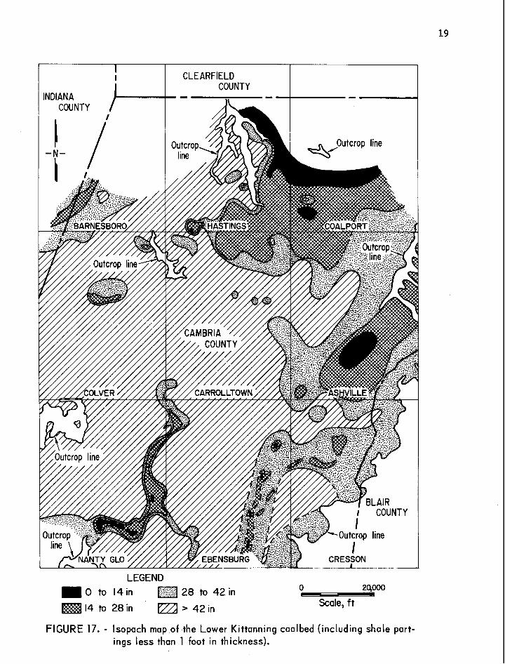
Corre la t ion of sandstone-fi l led channels wi th "wants" i s f u r t h e r improved by construct ing a map ( f i g . 16) showing areas of t h i n coal i n r e l a t i o n t o the Lower IJorthington Sandstone where i t is a t l e a s t 20 f e e t t h i c k and wi th in 10 f e e t of the underlying Lower Kittanning coalbed. The 28-inch l i n e ( f i g . 1 6 ) was a r b i t r a r i l y se lec ted t o ind ica te possible '%ant" areas because the continuous-mining machines used i n t h i s a rea have a lower l i m i t of 28 inches. It i s bel ieved t h a t "wants," indicated by the 28-inch l i n e and associa ted with areas where the Lower Worthington Sandstone i s a t l e a s t 20 f e e t t h i c k and within 10 f e e t of the underlying coalbed, a re of the e ros iona l type.
There may be a "want" i n the north-south-trending area of Lower Worthing- ton Sandstone i n the Carrolltown quadrangle ( f i g . 16). Although a l l the cores from t h a t a rea show a minable thickness of coal ( f i g . 17 ) , two show a t h i c k sandstone d i r e c t l y on top of the coalbed. I n areas adjacent t o those from where these cores came, it i s possible t h a t t h i s sandstone extends down i n t o the coalbed t o reduce i t s thickness or perhaps even cut i t out completely.
Another type of "want" i s one i n which a minable coalbed s p l i t s i n t o sev- e r a l thinner coalbeds which a r e not mined individual ly o r together because of the excessive intervening rock. Often the t o t a l thickness of the s p l i t coal i s l e s s than t h a t of the t o t a l undivided coalbed. This i s re fe r red t o a s a deposi t ional "want" or " sp l i t . " Moore (l3) explained the o r ig in of s p l i t s a s follows :
S p l i t s a r e due t o the f a c t t h a t while the vege ta l matter is being l a i d down i n the swamp there a re periods when c lay o r sand i s brought i n by water from the surrounding lands and ca r r i ed out over the vegeta l matter .
The Lower Kit tanning coalbed, genera l ly 4 f e e t t h i c k ( f ig . 17) , s p l i t s i n t o a s many as three coa l u n i t s wi th in 25 f e e t of sec t ion i n the nor theas tern por t ion of the study area ( f i g s . 18-19). This "want" area ( l e s s than28 inches of coa l , f i g . 17) i s considered t o be deposi t ional i n o r i g i n based on the s t r a t i g r a p h i c cross sec t ions ( f i g s . 18-19).
Types of Unstable Roof
Roof-rock s t r a t a a f f e c t the physical condit ion of the roof and type of support needed t o maintain a good roof i n a coal mine. Observation of many roof f a l l s and areas of unstable roof i n the f i v e underground mines led the authors t o i d e n t i f y f i v e types of unstable roof r e l a t e d t o the geologic condi- t ions . They a r e characterized a s follows:
1. Slickensided disconformit ies on the underside o f t h e channel sandstones.
2. Randomly oriented sl ickensided s l i p planes r e s u l t i n g from slumping as the sediments were undergoing consolidat ion. Commonly found i n black shales above the coalbed.
3 . Slickensided s l i p planes caused by d i f f e r e n t i a l cumpaction of sand- stone and adjacent shale .
4 . Abrupt l a t e r a l pinchouts or wedges of s t r a t a (general ly t h i n sand- s tone pinchouts) ,
LEGEND 0 to 14 in 28 to 42 in 0 L - 24000 j
14 to 28 in > 42 in Scale, f t
FIGURE 17. - lsopach map of the Lower Kittanning coal bed (including shale part- ings less than 1 foot in thickness).

Upp
er c
oal o
r "r
ider
" co
al
LEG
EN
D
I(D Bo
ny c
oal
s~
dy
sh
ak
..., ; Sa
ndst
one
Cla
ysto
ne
LEG
END
-1
rm ~o
ny
coal
K
ey m
ap
Sand
ston
e
Shal
e
Sand
y sh
ale
FIG
UR
E 1
8. -
Str
atig
rap
hic
sec
tio
nso
f the
Lo
wer
Kit
tan
nin
g
FIG
UR
E 1
9. -
Str
atig
rap
hic
sec
tio
nso
f the
Lo
wer
Kit
tan
nin
g
coal
gro
up a
nd l
oca
tio
n o
f cr
oss
sec
tio
ns.
co
al g
roup
.

5. Abrupt l i t h o l o g i c boundaries between c l a y s , s h a l e s , s i l t s t o n e s , sand- s tones , and c o a l , causing planes of weakness.
Of the f i v e types of unstable r o o f , a reas with sl ickensided surfaces on the underside and adjacent t o the Lower Worthington Sandstone and abrupt l i t h o - logic boundaries of the Middle Kittanning coalbed can be i d e n t i f i e d , with the a id of core log d a t a , i n advance of mining.
Slickensided f rac tu res a r e commonly present adjacent t o and on the under- s ide o f t h e th ick channel sandstone abovetheLower Kittanning coalbed ( f i g . 20) . These f r ac tu res a r e caused by d i f f e r e n t i a l compaction and by soft-sediment s l i d i n g along and adjacent t o the contact between the sand-f i l led channels and the shale t h a t under l ies the sandstone.
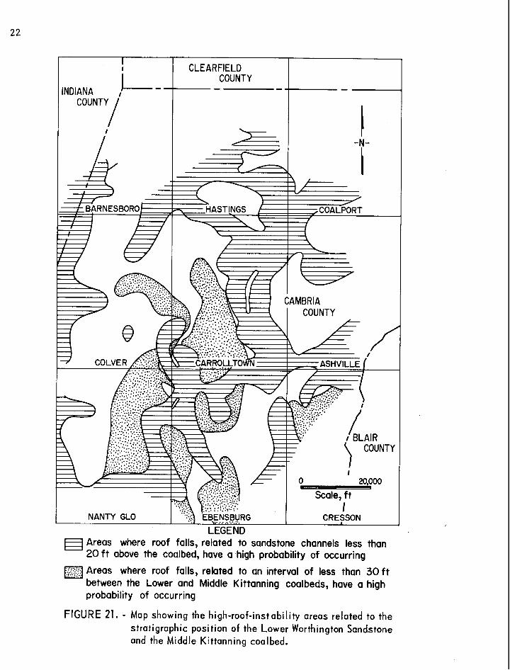
The s l ickensided surfaces a r e planes of weakness. When unsupported, shales , c l a y s , and t h i n "r ider" coals beneath and adjacent t o channel sandstones e a s i l y separa te and f a l l i n t o mine rooms (12). The underside of such a channel repre- sen t s a disconformable surface . The c l o s e r the underside of the channel sand- s tone is t o the top of the coalbed, the g rea te r the chance of roof f a i l u r e . Figure 21 shows areas where t h e i n t e r v a l from the top of the Lower Kit tanning
LEGEND
coal # Shale z L 151cale, ft 3
/ Sandstone Sa"dy shale 0 15 Horizontal
FIGURE 20. - Generalized cross section of characteristic unstable roof associated with sandstone channels.
LEGEND Areas where roof falls, related to sandstone channels less than 20 f t above the coalbed, have a high probability of occurring
Areas where roof fallsi related to an interval of less than 3 0 f t ... .. between the Lower and Middle Kittanning coalbeds, have a high probability of occurring
FIGURE 21. - Map showing the high-roof-instability areas related to the stratigraphic position of the Lower Worthington Sandstone and the Middle Kittanning coal bed.

coalbed t o the bottom of the Lower Worthington Sandstone i s l e s s than 30 f e e t . Roof i n s t a b i l i t y increases g rea t ly i n such areas .
Another type of roof i n s t a b i l i t y i s associa ted with the abrupt l i t h o l o g i c boundaries of the Middle Kit tanning coalbed ( f i g . 22). Benedict (1) noted t h i s c h a r a c t e r i s t i c i n the Bethlehem No. 32 m i n e :
According t o the experience of mine opera to r s , when the th ick- ness of t h i s u n i t i s l e s s than 20 f e e t , the bond between the over- ly ing coal and i t s associa ted underclay of t e n f a i l s , thus causing the e n t i r e s t r a t i g r a p h i c u n i t t o f a l l i n t o the mining area below.
Benedict mapped the i n t e r v a l from the Lower Kittanning coalbed t o the next h ighes t coalbed, because a t h i c k "r ider" coalbed occurs l o c a l l y between the Middle and Lower Kittanning coalbeds on ~ e t h l e h e m ' s property. However, regional ly t h i s coalbed i s discontinuous and very t h i n , unlike the r eg iona l ly p e r s i s t e n t Middle Kittanning coalbed ( f i g . 7 ) .
Wherever the Middle Kittanning coalbed i s l e s s than 30 f e e t above the Lower Kittanning coalbed, the frequency of roof f a l l s i s increased. I n one area of the Colver mine, where the i n t e r v a l i s l e s s than 30 f e e t , more than ha l f of the e x i s t i n g roof f a l l s extended upward t o the top of the Middle Kittanning coalbed.
The increase i n t h i s type of roof i n s t a b i l i t y i s r e l a t e d t o the sharp l i t h o l o g i c contac ts between the Middle Kittanning coalbed and the sha le above and the underclay below t h i s coalbed. These contac ts represent planes of s t r u c t u r a l weakness. I n t h i s t h i n i n t e r v a l , void of channel sandstones , a l t e r - na t ing l i t h o l o g i e s a r e genera l ly gradat ional , unlike the coal-shale and coal- underclay contac ts . Figure 21 shows areas where the i n t e r v a l i s l e s s than
LEGEND
coal Shale
.:>:....:, ;.;, Sandstone Claystone
Sandy shale 0 15
Horizontal
30 f e e t , i nd ica t ing a reas where t h i s type of uns table roof w i l l increase i n f r e - quency. This type of unsta- b l e roof i s common i n mines i n e a s t e r n NantyG10,western Ebensburg , e a s t e r n Colver , and western Carrolltown quadrangles ( f i g . 2 1) .
Unstable roof s t r a t a described above may occur when support ing coa l i s f i r s t remwed. Also w e r long periods of t ime, moist mine a i r , moving through f rac - tu res and s l ickens ided planes i n the roof , weakens contac t FIGURE 22. - Generalized cross section of characteristic bonds between lithologies.
unstable roof associated with thinning of the interval shales and especially clay- between the top of the Lower Kittanning coalbed and stones sof ten and become the bottom of the Middle Kittanning coalbed.
1
d i f f i c u l t t o support, so t ha t same roof f a l l s may occur i n the l a t e r stages of mining. Unstable roof associated with sl ickensides resu l t ing from slumping and abrupt l a t e r a l pinchouts of s t r a t a were found t o be local i n extent and extremely d i f f i c u l t t o predic t i n unmined areas.
So f a r we have discussed unstable roof problems associated with geologic conditions. However, not a l l unstable roof can be re la ted t o geologic in£ lu- ences . An example of t h i s i s an elongated roof f a l l occurring p a r a l l e l t o the r i b , commonly referred t o as a "cutter." The or ig in of "cutters" i s unclear. They generally occur pa ra l l e l t o the r i b s ( f ig . 23) but are a l so found t o cut across en t r i e s . There are no bedding disturbances or s lickensided surfaces associated with a "cutter ." One of the more probable explanations fo r t h e i r occurrence could be abnormally high horizontal s t r e s s forces i n the rock s t r a t a . "Cutters" are among the many roof f a i l u r e conditions observed t ha t need t o be investigated i n much greater d e t a i l .
METHANE EMISSION
Methane i s always present i n coal and can cons t i tu te a serious sa fe ty hazard i n coal mining. Several other gases are associated i n f a r l e s s amounts with methane i n coal . These include hydrogen, water vapor, ni trogen, carbon dioxide, and helium (z). Gas content of a coalbed i s primarily influenced by depth and rank. During mining, methane emission from a coalbed i s controlled by porosity, permeability, and gas pressure.
The most e a s i l y documented geologic fac tor influencing methane content of coal i s depth. Generally a t greater depths and therefore higher pressures, a greater volume of gas i s held within the coal. Also, since the gas a t g rea te r depths i s contained under higher pressure, it i s released i n l a rger volumes during mining ( 2 ) . Figure 24 i s an isopach map of the overburden above the Lower itt tanning coalbed. It i s expected t ha t i n the deeper par t s of the study area , the gas content of the coalbed w i l l increase. This i s p a r t l y sub- s tan t ia ted by work done by Puglio (IS) i n nearby Indiana County. A sample of the Lower Kittanning coalbed taken from a depth of 623 f e e t contained only about 1 cm3 /g (32 f t 3 /ton) of methane, while a sample taken £ran a depth of 1,060 f ee t contained about 11 cm3/g (352 f t3 / ton) .
A second geologic fac tor influencing the methane content of coal i s rank. K i m (g), i n comparing ac tua l gas contents of coals with d i f f e r en t ranks and depths, considered rank a s an a id i n estimating methane content of bituminous coals. Stach (17) s ta ted t ha t i n the d i f f e r en t coa l i f i ca t ion stages large amounts of methane are generated i n the medium-volatile t o anthraci te range. Additionally, Joubert (5) showed tha t increased moisture content i n coal reduces i t s capacity t o absorb methane. Because the Lower Kittanning coalbed i n the study area i s a low- t o medium-volatile bituminous coal (high rank, low moisture content) , it contains more methane gas than lower rank coals .

- . . . * W"' -. .
I %a'
FIGURE 23. - "Cutter" occurring paral le l to the rib.

!8m0 to 200 ft 600 to 800 ft 0 200 to 400 ft
C-C-20,000 EZl800 to 1,000 ft a 400 to 600 ft
Scale, ft m 1,000 to 1,200 ft
INDIANA 1 COUNTY I
FIGURE 24. - lsopach map of the overburden above the Lower Kittanning coalbed.
CLEARFIELD COUNTY

Possibly the best indicator of the high methane content of t h i s coalbed i s the high methane emissions encountered i n deeper mines. As shownintable 1, the average methane emissions from mines within the study area increase sub- s t a n t i a l l y with depth.
TABLE 1. - Average methane emission d u r i n g c o a l p r o d u c t i o n a n d d e ~ t h of s i x act ive deep mines i n Lower Kittanning coalbed
Geologic factors influencing methane emissions from a coalbed during min- ing are porosity, permeability, and gas pressure. Porosity measurements a re d i f f i c u l t t o make, but porosity i s believed t o depend on charac te r i s t i c mois- ture content (6) and rank (2). Although by de f in i t i on primary permeability i s through the so l id coal microstructure, secondary permeability (permeability along c l ea t f racture planes or f racture permeability) i s higher. Fracture permeability i s one of the control l ing factors i n migration and re tent ion of methane i n a coalbed.
Coal mine
Eastern Associated, Colver.. .... Bethlehem No. 31................ Barnes and Tucker No. 24B.. ..... Barnes and Tucker No. 20........ Bethlehem No. 33................ Bethlehem No. 32................
Directional permeability of coal i s dependent on or ien ta t ion and density of the c l ea t f racture . Kissel l (2) showed gas emissions from the Pit tsburgh coalbed i n Greene County, Pa., t o be 2.5 t o 10 times higher where hor izontal degasi f icat ion holes were d r i l l e d perpendicular t o face c l ea t than emissions with the holes perpendicular t o the bu t t c l ea t . Because of the f r i a b l e nature of the Lower Kittanning coalbed i n the study area and several d i f f e r en t clus- t e r i n g ~ of face and bu t t c l e a t orientat ions ( f ig . 13) , it i s expected t ha t the f racture permeability w i l l vary i n d i f fe ren t d i rect ions but not as much as that of the more b locky coalbeds .
Only a small percentage of the coal lying deeper than 700 f e e t has been mined. More than 80 percent of the remaining minable reserves l i e deeper than 600 fee t i n Ebensburg , eastern Carrolltown, western Ashville , and northwestern Cresson quadrangles ( f i g . 24). Mining i n these areas can be expected t o encounter very high methane emissions, whereas comparatively low methane emis- sions can be expected i n mining the remaining reserves close t o the outcrop i n eas tern Ashville quadrangle and northern Cresson quadrangle. Direct determina- t ion (11) of methane content of coal cores from exploration d r i l l holes w i l l g r e a t l y a i d i n calculating the methane content i n the unmined areas of the coalbed.
Average me thane emission (1976),
MMc f d 400,000 212,000 274,000
2 ,643,000 2,695,000 3,101,000
More localized geologic factors influencing methane emissions a re coalbed thickness ( f ig . 17) , presence of other coalbeds above the coalbed presently being mined ( f ig . 7 ) , porous sandstone ly ing between source rocks ( f ig . 7 ) , s t r uc tu r e , and proximity t o outcrop ( f ig . 24).
Average depth, f e e t
3 00 350 400 500 650 7 00

SUMMARY AND CONCLUSIONS
Using data gathered from core logs , mine maps, and geologic mine surveys, the geology of the Lower Kittanning coalbed was invest igated and i t s influence on mining was determined. The important c h a r a c t e r i s t i c s of the s t r a t ig raphy of the coalbed follow:
1. The Lower Kittanning coal group i s made up of a l l the coalbeds between t h e Kittanning Sandstone and L w e r Worthington Sandstone.
2 . The Lower Kittanning coal group i s general ly composed of a t h i n upper coal (Lower Kittanning "rider" coal) and a th ick lower coal (Lower Kittanning coalbed).
3 . The lower coal of the Middle Kittanning coal group i s dist inguished from the Lower Kittanning "rider" coal by the presence of a t h i c k underclay below the former and a carbonaceous s h a l e , s i l t s t o n e , or sandstone below the l a t t e r .
4. The Middle Kittanning coal group l i e s 20 t o 60 f e e t above the Lower Kittanning coalbed, i s e r r a t i c i n th ickness , and s p l i t s i n t o many t h i n benches of coal through the area.
Important deposi t ional va r ia t ions t h a t were examined and t h a t influence coal ex t rac t ion follow:
1. The Lower Worthington Sandstone i s a sand-f i l led channel depos i t , ranging i n thickness from 0 t o 60 fee t . Locally it erodes through key marker un i t s .
2. The Lower Worthington Sandstone i s general ly present i n the i n t e r v a l between the Lower and Middle Kittanning coal groups. A thickening of t h i s in te rva l i s associated with the presence of the Lower Worthington Sandstone.
3 . Wherever the Lower t o Middle Kittanning i n t e r v a l i s l e s s than 30 f e e t th ick , there i s general ly no channel-type sandstone present . Ins tead, t h i s i n t e r v a l i s composed of t h i n tabular sandstones and shales t h a t grade v e r t i - c a l l y and hor izonta l ly i n t o sandy and s i l t y gray shales .
4. The most d i s t i n c t i v e hor izonta l breaks o r zones of weakness between l i tho log ies occur between the rocks above and below a coalbed and a l s o a t the bottom of sandstone channels.
5. 'Vants" are e i t h e r eros ional or deposi t ional i n nature. Erosion i s accomplished by d i s t r i b u t a r y channels cu t t ing i n t o the coalbed and washing it away. Variat ions i n deposit ion influence the development of "wants" i n the form of s p l i t s o r thinning of the coalbed.

Conclusions drawn from t h i s inves t iga t ion are--
1. "Wants," located by coa l isopach and mine maps, show a high cor re la - t i o n with areas where the bottom of the Lower Worthington Sandstone comes wi th in 10 f e e t of the top of the Lower Kittanning coalbed. Therefore, the occurrence of "wants" can be predicted i n advance of mining i f s u f f i c i e n t explorat ion data a r e avai lable .
2 . Roof rock i n s t a b i l i t y can be linked with t h e c lose pos i t ion of e i t h e r a channel sandstoneor the Middle Kittanning coalbed above the Lower Kittanning coalbed. This cbndit ion can be used i n predict ing areas of unstable roof i n unmined coal and can a i d i n designing an e f f e c t i v e roof-bolt ing plan.
3 . High mithane emissions i n the Lower Kittanning coalbed a r e influenced by r e l a t i v e l y great depths, high rank, and good f rac tu re permeability.
4. The already serious problem of high methane emissions w i l l become even g rea te r i n fu ture ex t rac t ion of the deeper areas of coal .
A long mining h i s t o r y and an ac t ive explora t ion program t o del ineate deep reserves character izes the area under inves t iga t ion , A s these deeper reserves are exploi ted , an understanding of geologic fac to r s a f f e c t i n g mining i n the v i r g i n coal w i l l a i d i n planning more productive mines with b e t t e r hazard evasion.

REFERENCE S
Benedict , L. G. , and R. R. Thompson. The Use of Geological Informatfon To Describe Coal-Mine Roof Conditions. Pres. a t 166th Nat. Meeting, Div. Fuel Chem. , ACS , Chicago, 111. , Aug. 26-31, 1973, 13 pp. ; a v a i l - able f o r consul ta t ion a t Bureau of Mines Mining and Safety Research Center , P i t t sburgh, Pa.
Deul, M. Methane Drainage From Coalbeds: A Program of Applied Research. Proc. 60th Meeting, Rocky Mountain Coal Mining I n s t i t u t e , Boulder, Colo. , June 30-July 1, 1964, pp. 54-60.
Diamond, W . P., C . M. McCulloch, and B. M. Bench. Use of Surface J o i n t and Photolinear Data f o r Predict ing Subsurface Coal Cleat Or ienta t ion . BuMines R I 8120, 1976, 13 pp.
F l i n t , N. K. Geology and Mineral Resources of Southern Somerset County, Pennsylvania. Pa. Geol. Survey, C56A, 1965, 267 pp.
I r a n i , M. C . , J . H. Jansky, P. W . Je ran , and G. L. Hasset t . Methane Emission From U.S. Coal Mines i n 1975, A Survey. A Supplement t o Information Circulars 8558 and 8659. BuMines I C 8733, 1977, 55 pp.
Joubert , J. I., C . T. Grein, and B. Bienstock. Sorption of Methane i n Moist Coal. Fuel , v . 52, 1973, pp. 181-185.
K i m , A . G . The Composition of Coalbed Gas. BuMines R I 7762, 1973, 9 pp.
. Estimating Methane Content of Bituminous Coalbeds Frcm Adsorption Data. BuMines R I 8245, 1977, 22 pp.
K i s s e l l , F. N. The Methane Migration and Storage Charac te r i s t i c s of the Pi t t sburgh, Pocahontas No. 3 , and Oklahoma Hartshorne Coalbeds. BuMines R I 7667, 1972, 22 pp.
McCulloch, C . M. , and M. Deul. Geologic Factors Causing Roof I n s t a b i l i t y and Methane Emission Problems : The Lower Kittanning Coalbed, Cambria County, Pa. BuMines R I 7769, 1973, 25 pp.
McCulloch, C. M. , J. R . Levine, F. N. K i s s e l l , and M. Deul. Measuring the Methane Content of Bituminous Coalbeds. BuMines R I 8043, 1975, 22 PP*
Moebs, N. N. Roof Rock St ructures and Related Roof Support Problems i n the Pit tsburgh Coalbed of Southwestern Pennsylvania. BuMines R I 8230, 1977, 30 pp.
Moore, E . S. Coal: I t s Proper t ies , Analysis , C l a s s i f i c a t i o n , Geology, Ex t rac t ion , Uses and Dis t r ibut ion . John Wiley & Sons, I n c . , New York, 1922, 462 pp.
Nickelsen, R . , and V . N . S. Hough. Jointing i n the Appalachian Plateau of Pennsylvania. Geol. Soc. America Bull. , v. 78, 1967, pp. 609-630.
Puglio, D . G. Geology of the Kittanning Coalbeds (Kittanning Formation) i n Portion of Indiana and Westmoreland Counties, Pennsylvania. Abs. with Programs, 13th Ann. Meeting, Northeastern Sec . , Geol. Soc . America, v. 10, No. 2, January 1978, p. 80.
Spieker, E . M. Sedimentary Facies and Associated Diastrophism i n the Upper Cretaceous of Central and Eastern Utah. Geol. Soc. America, Memoir 39, June 1949, pp. 55-82.
Stach, E . , M.-Th. Machowsky, T. Teichmuler, G. H. Taylor, D. Chandra, and R. Teichmuler. tach's Textbook of Coal Petrology. Grbruder Burntraeger, Berl in-Stuttgart , 2d ed., 1975, pp. 40, 200, 329.
Thomas , J. , and H. Damberger . Internal Surface Area, Moisture Content, and Porosity of I l l i n o i s Coal: Variation With Coal Rank. Ill. Sta te Geol. Survey Circ. 493, 1976, 39 pp.
Waage , K. M. Refractory Clays of the Maryland Coal Measures. Md. Dept. Geol. , Mines and Water Res . Bull. 9 , 1950, pp. 11-32.
Weller, J. M. Arguments fo r Diastrophic Control of Late Paleozoic Cyclothems. Am. Assoc. Petrol . Geol. Bull. , v. 40, January 1956, pp. 17-50.
Williams, E . G. Stratigraphy of the Allegheny Series i n the Clearf ie ld Basin. Ph.D. Thesis, Pa. S ta te Univ., S ta te College, Pa., 1957, 454 pp.
Williams, E . G., A. L. Guber, and A . H. Johnson. Rotational Slumping and the Recognition of Disconformities . J. Geol . , v. 74, No. 3 , Nay 1965, pp. 534-547.
*U.S. GOVERNMENT PRINTING OFFICE: 1980-603-102109
Recommended