Geo327G/386G: GIS & GPS Applications in Earth SciencesJackson School of Geosciences, University of Texas at Austin
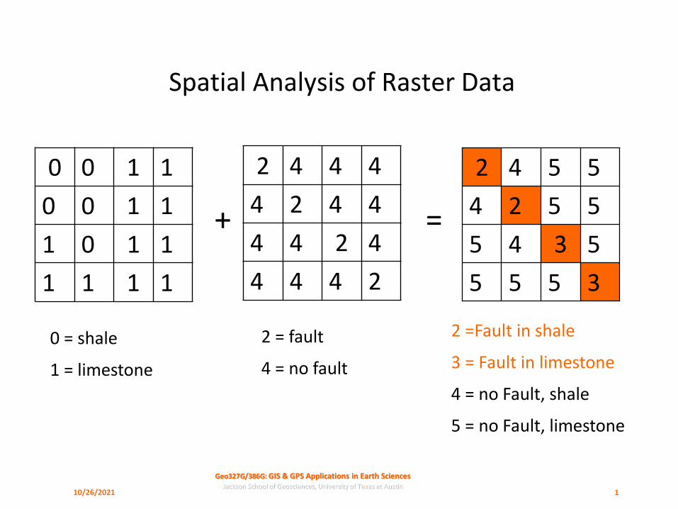
Spatial Analysis of Raster Data
0 0 1 1
0 0 1 1
1 0 1 1
1 1 1 1
2 4 4 4
4 2 4 4
4 4 2 4
4 4 4 2 3555
5345
5524
5542
+ =
0 = shale
1 = limestone
2 = fault
4 = no fault
2 =Fault in shale
3 = Fault in limestone
4 = no Fault, shale
5 = no Fault, limestone
10/26/2021 1

Geo327G/386G: GIS & GPS Applications in Earth SciencesJackson School of Geosciences, University of Texas at Austin
What is Spatial Analysis?
❑Spatial Query:“Where is…?”
❑Spatial Analysis (e.g. suitability analysis):“Where is the best place for…?”“What is the least costly path between…?”
❑“… a set of methods with results that change when the location of objects being analysed changes” –the spatial aspect of this form of analysis sets it apart
10/26/2021 2

Geo327G/386G: GIS & GPS Applications in Earth SciencesJackson School of Geosciences, University of Texas at Austin
Why Rasters?
❑Conceptually simple, easy to implement
❑Well-suited for surface- and field-related phenomena (e.g. elevation, gravity, rainfall, etc.) and for discrete features
❑Wide availability of data-sets; all remotely sensed data of this sort
❑De facto standard approach – oldest, most widely implemented, mature, widest suite of tools and software
❑Best suited for “Where” rather than “What” questions
10/26/2021 3

Geo327G/386G: GIS & GPS Applications in Earth SciencesJackson School of Geosciences, University of Texas at Austin
Where do rasters come from?
❑Converted vector files, e.g. shapefiles, coverages – Tools available
❑Created from interpolations of point values – Tools available
❑Directly from raster sources; remotely sensed data, DEMs, meteorological measurements, etc.
1 1 1
1 1 2
1 2 3
1 2 3
pC1
pC2
pC3
6
8
5
8
10/26/2021 4
Geo327G/386G: GIS & GPS Applications in Earth SciencesJackson School of Geosciences, University of Texas at Austin
What gets stored?
❑Cell values may be:
❑ Nominal – integers are attribute codes (tags)
❑ Ordinal – integers are ranks
❑ Ratio – Ratio of values makes sense, e.g. 300 m elevation is twice as high as 150 m; magnitude of ratio has some physical meaning
10/26/2021 5
Geo327G/386G: GIS & GPS Applications in Earth SciencesJackson School of Geosciences, University of Texas at Austin
What gets stored?
❑Cell values may be:
❑ Nominal – integers are attribute codes (tags). Though numbers, they are dimensionless and without scale.
❑ Numbers as qualitative descriptors.
Mathematical operations on cell values are not meaningful as a measure of scalar magnitudes.
10/26/2021 6
Geo327G/386G: GIS & GPS Applications in Earth SciencesJackson School of Geosciences, University of Texas at Austin
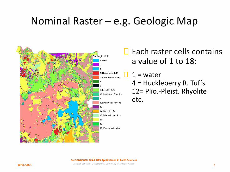
Nominal Raster – e.g. Geologic Map
Each raster cells contains a value of 1 to 18:
1 = water4 = Huckleberry R. Tuffs12= Plio.-Pleist. Rhyoliteetc.
10/26/2021 7

Geo327G/386G: GIS & GPS Applications in Earth SciencesJackson School of Geosciences, University of Texas at Austin
What gets stored?
❑Cell values may be:
❑ Ordinal – integers are ranks
❑ e.g. 1=excellent, 2=good, 3=poor; 1=low, 2=medium, 3=high
❑ Ranking scheme used for hazard rating, density measures, etc.
❑Mathematical & most statistical operations meaningless; Median might be useful measure of central value
10/26/2021 8

Geo327G/386G: GIS & GPS Applications in Earth SciencesJackson School of Geosciences, University of Texas at Austin
Ordinal Raster – e.g. Erosion Ranking
Each raster cells contains a value of 1-12
Yellow = 12 = Most Erosive
Blue = 1 = Least Erosive
10/26/2021 9
Geo327G/386G: GIS & GPS Applications in Earth SciencesJackson School of Geosciences, University of Texas at Austin
What gets stored?
❑ Cell values may be:
❑ Ratio – data are organized along a continuum and numbers do have an absolute meaning
❑ e.g. lengths, volumes, heights, concentrations, etc.
Multiplication/Division, Subtraction/Addition make sense for arriving at meaningful new cell values.
10/26/2021 10

Geo327G/386G: GIS & GPS Applications in Earth SciencesJackson School of Geosciences, University of Texas at Austin
Ratio Raster – e.g. Elevation above MSL
Each raster cells contains a value of 1544-3578 (meters)
White = 3578 m
Pale Blue = 1544 m
10/26/2021 11
Geo327G/386G: GIS & GPS Applications in Earth SciencesJackson School of Geosciences, University of Texas at Austin
What Gets Stored?
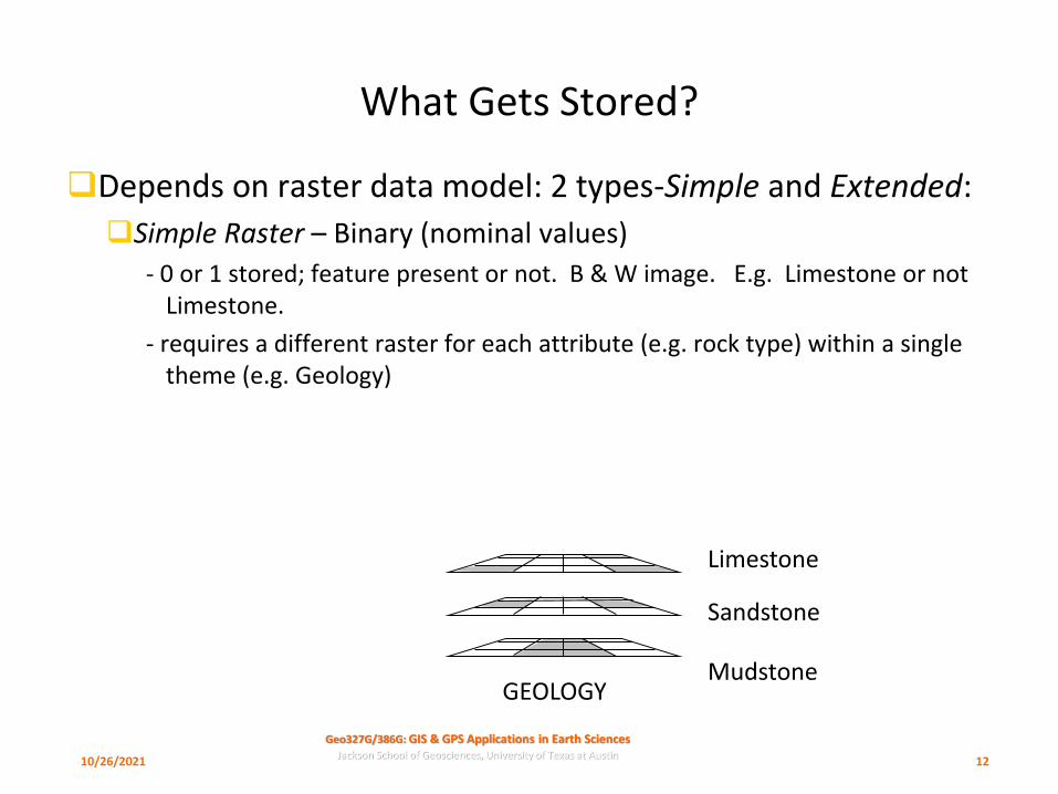
❑Depends on raster data model: 2 types-Simple and Extended:
❑Simple Raster – Binary (nominal values)
- 0 or 1 stored; feature present or not. B & W image. E.g. Limestone or not Limestone.
- requires a different raster for each attribute (e.g. rock type) within a single theme (e.g. Geology)
Limestone
Sandstone
MudstoneGEOLOGY
10/26/2021 12
Geo327G/386G: GIS & GPS Applications in Earth SciencesJackson School of Geosciences, University of Texas at Austin
What Gets Stored?
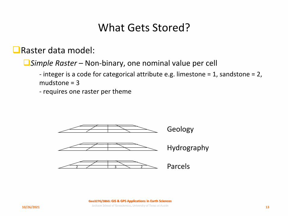
❑Raster data model:
❑Simple Raster – Non-binary, one nominal value per cell
- integer is a code for categorical attribute e.g. limestone = 1, sandstone = 2, mudstone = 3- requires one raster per theme
Geology
Hydrography
Parcels3 22
10/26/2021 13
Geo327G/386G: GIS & GPS Applications in Earth SciencesJackson School of Geosciences, University of Texas at Austin
What Gets Stored?
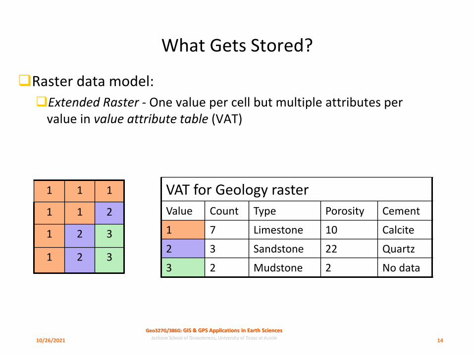
❑Raster data model:
❑Extended Raster - One value per cell but multiple attributes per value in value attribute table (VAT)
VAT for Geology raster
Value Count Type Porosity Cement
1 7 Limestone 10 Calcite
2 3 Sandstone 22 Quartz
3 2 Mudstone 2 No data
1 1 1
1 1 2
1 2 3
1 2 3
10/26/2021 14
Geo327G/386G: GIS & GPS Applications in Earth SciencesJackson School of Geosciences, University of Texas at Austin
What Are the Tools &Techniques?
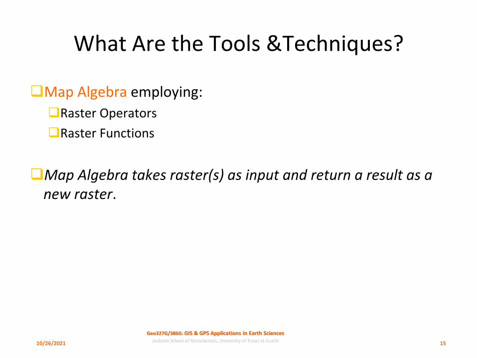
❑Map Algebra employing:
❑Raster Operators
❑Raster Functions
❑Map Algebra takes raster(s) as input and return a result as a new raster.
10/26/2021 15
Geo327G/386G: GIS & GPS Applications in Earth SciencesJackson School of Geosciences, University of Texas at Austin
Map Algebra Operators
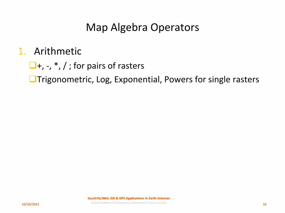
1. Arithmetic
❑+, -, *, / ; for pairs of rasters
❑Trigonometric, Log, Exponential, Powers for single rasters
10/26/2021 16
Geo327G/386G: GIS & GPS Applications in Earth SciencesJackson School of Geosciences, University of Texas at Austin
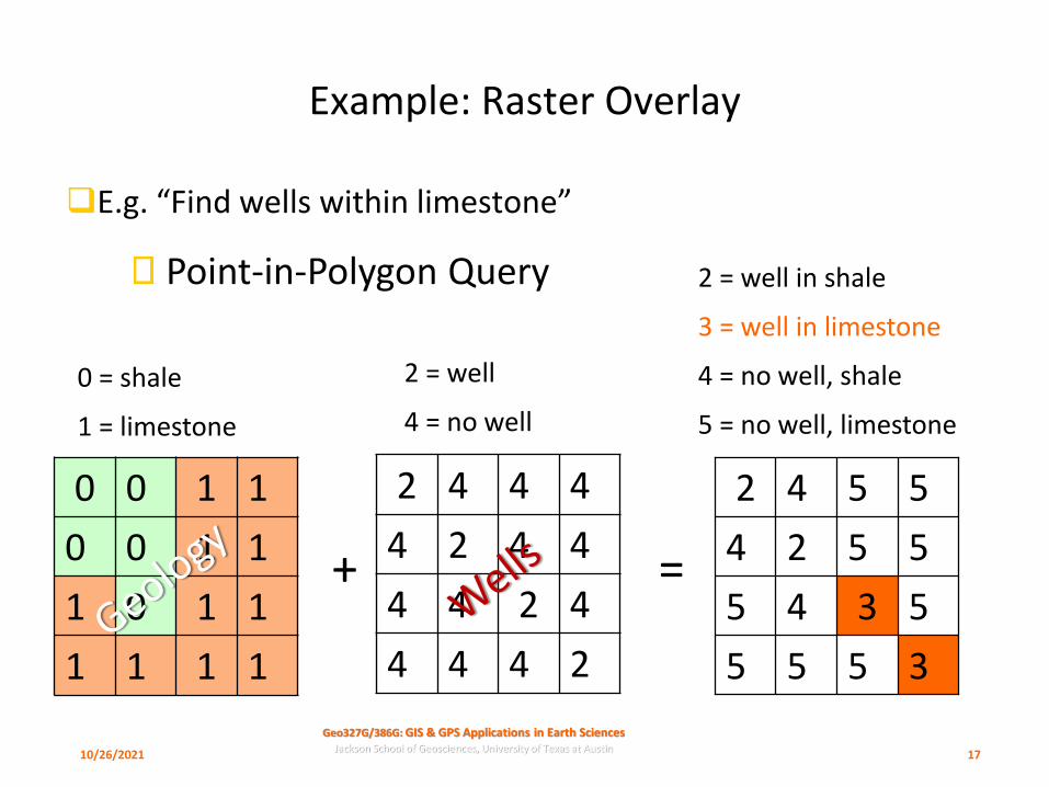
Example: Raster Overlay
❑E.g. “Find wells within limestone”
0 0 1 1
0 0 1 1
1 0 1 1
1 1 1 1
2 4 4 4
4 2 4 4
4 4 2 4
4 4 4 2 3555
5345
5524
5542
+ =
0 = shale
1 = limestone
2 = well
4 = no well
2 = well in shale
3 = well in limestone
4 = no well, shale
5 = no well, limestone
Point-in-Polygon Query
10/26/2021 17

Geo327G/386G: GIS & GPS Applications in Earth SciencesJackson School of Geosciences, University of Texas at Austin
Map Algebra Operators
2. Relational (e.g. raster comparisons)
❑ <, >, =, >=, <=, <>
Compare two rasters. Create a new raster such that if condition is false, return 0, if true 1.
4 0 0
0 4 4
0 3 3
0 3 3
5 5 5
5 5 2
5 2 3
5 2 3
1 1 1
1 1 0
1 0 1
1 0 1
>= =
10/26/2021 18

Geo327G/386G: GIS & GPS Applications in Earth SciencesJackson School of Geosciences, University of Texas at Austin
Boolean Selections; Or, And, Not
From Bolstad, 4th edition
10/26/2021 20

Geo327G/386G: GIS & GPS Applications in Earth SciencesJackson School of Geosciences, University of Texas at Austin
Map Algebra Operators
3. Boolean
❑And, Or, Not
❑ And – both true
❑ Or- either true
❑ Not – switches true for false
From Bolstad, 4th edition
10/26/2021 21
Search, compare and/or identify where there are non-zero values in two
rasters

Geo327G/386G: GIS & GPS Applications in Earth SciencesJackson School of Geosciences, University of Texas at Austin
Map Algebra Operators
3. Boolean
❑And, Or, Not, Xor
❑E.g. “Xor” (Exclusive Or) finds where there are nonzero values in one or the other raster, but not both.
4 0 0
0 4 4
0 3 3
3 35
5
0
5
32
32
25
5 0 1
0 0 0
1 0 0
0 0
! =
10/26/2021 22
Geo327G/386G: GIS & GPS Applications in Earth SciencesJackson School of Geosciences, University of Texas at Austin
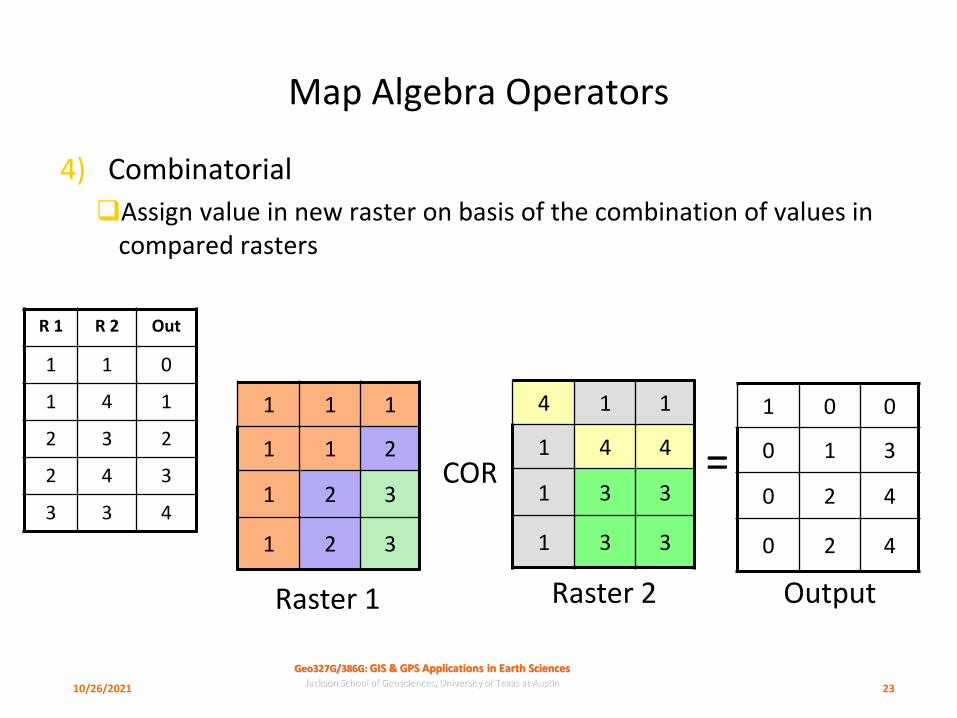
Map Algebra Operators
4) Combinatorial
❑Assign value in new raster on basis of the combination of values in compared rasters
4 1 1
1 4 4
1 3 3
1 3 3
1 1 1
1 1 2
1 2 3
1 2 3
1 0 0
0 1 3
0 2 4
0 2 4
COR =
Raster 1 Raster 2 Output
R 1 R 2 Out
1 1 0
1 4 1
2 3 2
2 4 3
3 3 4
10/26/2021 23
Geo327G/386G: GIS & GPS Applications in Earth SciencesJackson School of Geosciences, University of Texas at Austin
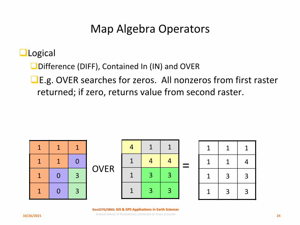
Map Algebra Operators
❑Logical
❑Difference (DIFF), Contained In (IN) and OVER
❑E.g. OVER searches for zeros. All nonzeros from first raster returned; if zero, returns value from second raster.
4 1 1
1 4 4
1 3 3
1 3 3
1 1 1
1 1 0
1 0 3
1 0 3
1 1 1
1 1 4
1 3 3
1 3 3
OVER =
10/26/2021 24
Geo327G/386G: GIS & GPS Applications in Earth SciencesJackson School of Geosciences, University of Texas at Austin
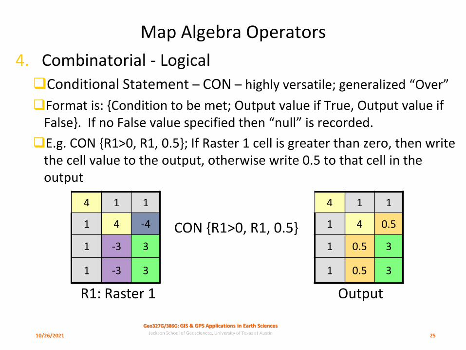
Map Algebra Operators
4. Combinatorial - Logical
❑Conditional Statement – CON – highly versatile; generalized “Over”
❑Format is: {Condition to be met; Output value if True, Output value if False}. If no False value specified then “null” is recorded.
❑E.g. CON {R1>0, R1, 0.5}; If Raster 1 cell is greater than zero, then write the cell value to the output, otherwise write 0.5 to that cell in the output
4 1 1
1 4 -4
1 -3 3
1 -3 3
4 1 1
1 4 0.5
1 0.5 3
1 0.5 3
CON {R1>0, R1, 0.5}
10/26/2021 25
R1: Raster 1 Output
Geo327G/386G: GIS & GPS Applications in Earth SciencesJackson School of Geosciences, University of Texas at Austin
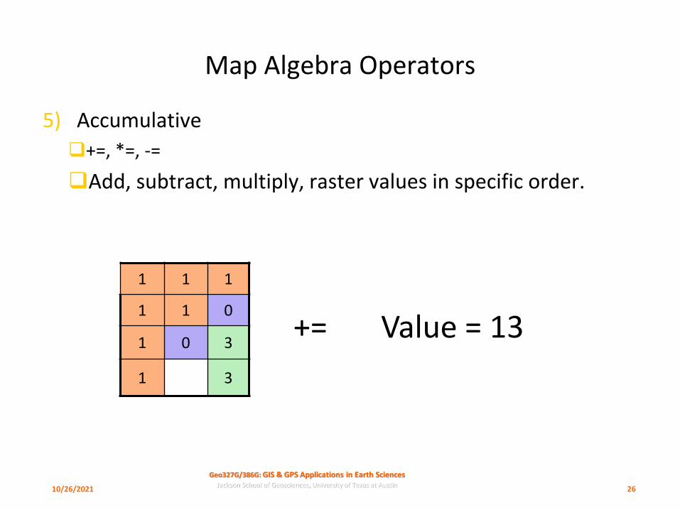
Map Algebra Operators
5) Accumulative
❑+=, *=, -=
❑Add, subtract, multiply, raster values in specific order.
1 1 1
1 1 0
1 0 3
1 3
+= Value = 13
10/26/2021 26

Geo327G/386G: GIS & GPS Applications in Earth SciencesJackson School of Geosciences, University of Texas at Austin
Map Algebra Operators
6. Assignment
❑=
❑Assign all cells in a new raster a value by performing operation on old raster
1 1 1
1 1 0
1 0 3
1 3
* 5 =
5 5 5
5 5 0
5 0 15
5 15
10/26/2021 27
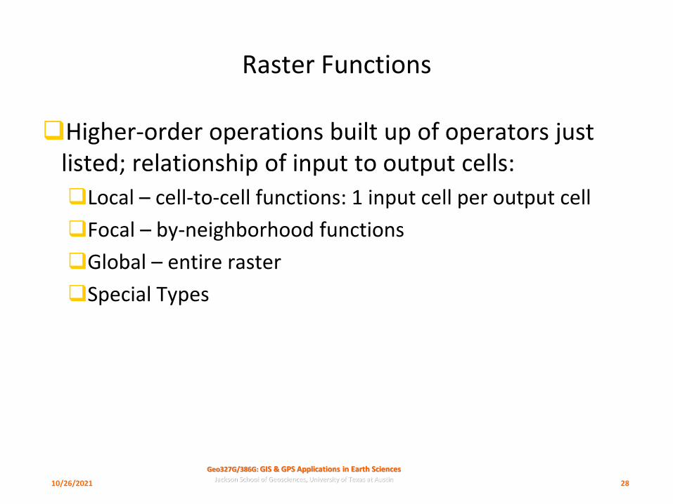
Geo327G/386G: GIS & GPS Applications in Earth SciencesJackson School of Geosciences, University of Texas at Austin
Raster Functions
❑Higher-order operations built up of operators just listed; relationship of input to output cells:
❑Local – cell-to-cell functions: 1 input cell per output cell
❑Focal – by-neighborhood functions
❑Global – entire raster
❑Special Types
10/26/2021 28
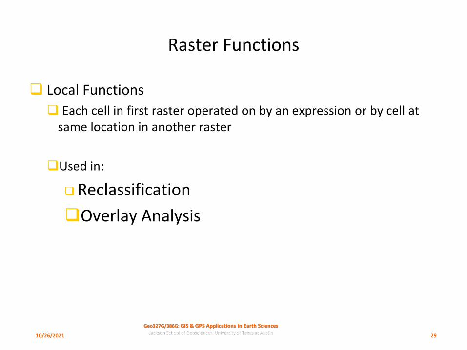
Geo327G/386G: GIS & GPS Applications in Earth SciencesJackson School of Geosciences, University of Texas at Austin
Raster Functions
❑ Local Functions
❑ Each cell in first raster operated on by an expression or by cell at same location in another raster
❑Used in:
❑Reclassification
❑Overlay Analysis
10/26/2021 29
Geo327G/386G: GIS & GPS Applications in Earth SciencesJackson School of Geosciences, University of Texas at Austin
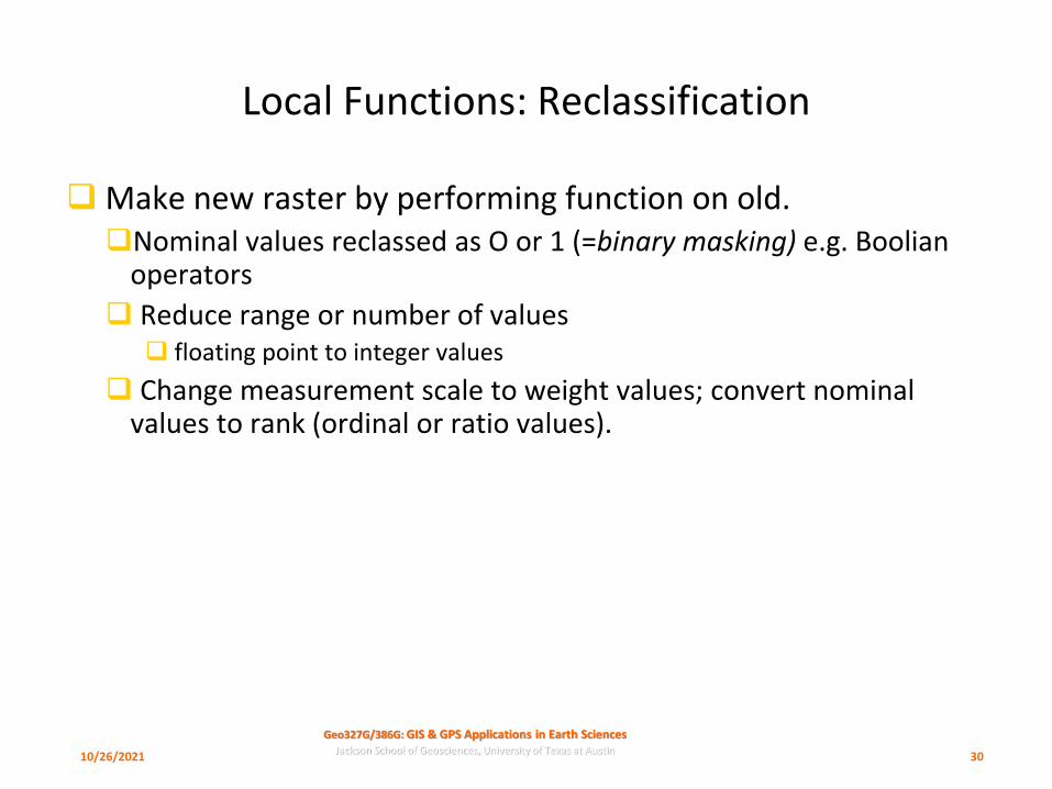
Local Functions: Reclassification
❑Make new raster by performing function on old. ❑Nominal values reclassed as O or 1 (=binary masking) e.g. Boolian
operators
❑ Reduce range or number of values❑ floating point to integer values
❑ Change measurement scale to weight values; convert nominal values to rank (ordinal or ratio values).
10/26/2021 30
Geo327G/386G: GIS & GPS Applications in Earth SciencesJackson School of Geosciences, University of Texas at Austin
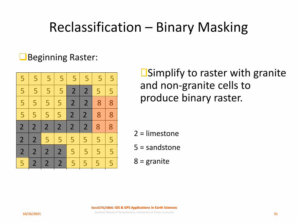
Reclassification – Binary Masking
❑Beginning Raster:
5 5 5 5 5 5 5
5
5
555 5 5 2 2
2 2 8 8
88225555
5555
2 2 22 2 8 82
2 55 55552
2 2 22 5 5 5 5
5555225 2
2 = limestone
5 = sandstone
8 = granite
Simplify to raster with granite and non-granite cells to produce binary raster.
10/26/2021 31
Geo327G/386G: GIS & GPS Applications in Earth SciencesJackson School of Geosciences, University of Texas at Austin
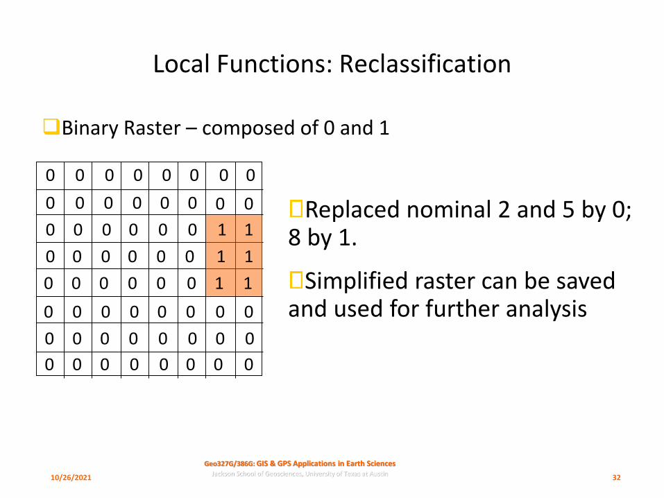
Local Functions: Reclassification
❑Binary Raster – composed of 0 and 1
Replaced nominal 2 and 5 by 0; 8 by 1.
Simplified raster can be saved and used for further analysis
0 0 0 0 0 0 0
0
0
000 0 0 0 0
0 0
000000
0000
0 0 00 0 0
0 00 00000
0 0 00 0 0 0 0
0000000 0
1 1
11
1 1
10/26/2021 32

Geo327G/386G: GIS & GPS Applications in Earth SciencesJackson School of Geosciences, University of Texas at Austin
Reclassification - Weighting
❑ Reclassify to assign weighting factor for further analysis; nominal values become ordinal values for later calculation
55
5 5 5 55 5 5 5
5 5 5 5
5555
5555 8 8
88
8 8
2 2
2 2
22
2 22 2 22
2 2 55 5555
5 5 5 5
5555
2 2 22
22 25
LithologyOld
ValueWeight New
Value
Limestone 2 10 20
Sandstone 5 2 10
Granite 8 5 40
Granite is weighted 4x sandstone and 2x limestone
10/26/2021 33

Geo327G/386G: GIS & GPS Applications in Earth SciencesJackson School of Geosciences, University of Texas at Austin
Local Functions: Raster Overlay
❑All entities represented by cells;
❑ point = single cell
❑ line = chain of cells
❑ polygon = group of cells
❑Nominal values identify a related group of cells as an entity
❑Rasters of continuous variables (e.g. rainfall, temp., elevation) have cells with ratio values
10/26/2021 34

Geo327G/386G: GIS & GPS Applications in Earth SciencesJackson School of Geosciences, University of Texas at Austin
Local Functions: Raster Overlay
❑Compare cell value among layers by Map Algebra
❑ generate new raster as sum, difference, product, etc. of cells within two layers
0 0 1 1
0 0 1 1
1 0 1 1
1 1 1 1
2 0 0 0
0 2 0 0
0 0 2 0
0 0 0 2
2 0 1 1
0 2 1 1
1 0 3 1
1 1 1 3
+ =
10/26/2021 35

Geo327G/386G: GIS & GPS Applications in Earth SciencesJackson School of Geosciences, University of Texas at Austin
Local Functions: Raster Overlay
❑E.g. “Find faults cutting limestone OR shale”
0 0 1 1
0 0 1 1
1 0 1 1
1 1 1 1
2 4 4 4
4 2 4 4
4 4 2 4
4 4 4 2 3555
5345
5524
5542
+ =
0 = shale
1 = limestone
2 = fault
4 = no fault
2 =Fault in shale
3 = Fault in limestone
4 = no Fault, shale
5 = no Fault, limestone
Line-in-Polygon Query
10/26/2021 36

Geo327G/386G: GIS & GPS Applications in Earth SciencesJackson School of Geosciences, University of Texas at Austin
Local Functions: Raster Overlay
❑ Operators include nearly all previously listed:
❑ Arithmetic
❑ Relational
❑ Logical
❑ etc.
10/26/2021 37
Geo327G/386G: GIS & GPS Applications in Earth SciencesJackson School of Geosciences, University of Texas at Austin
Focal Functions
❑ Neighborhood functions: uses values in adjacent cells to return values for new raster.
❑Used for:
❑ Aggregation
❑ Filtering
❑ Computing slope and aspect
10/26/2021 38
Geo327G/386G: GIS & GPS Applications in Earth SciencesJackson School of Geosciences, University of Texas at Austin
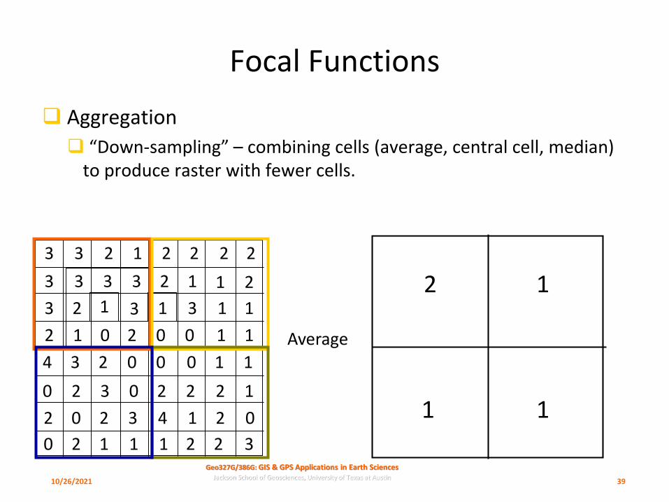
Focal Functions
❑ Aggregation
❑ “Down-sampling” – combining cells (average, central cell, median) to produce raster with fewer cells.
3 3 2 1 2 2 2
3
2
213 3 3 2 1
1 3
002012
23
4 3 02 0 0
0 12 22032
2 2 30 4 1 2 0
3221120 1
1 1
11
1 1
1 3
Average
2 1
11
10/26/2021 39

Geo327G/386G: GIS & GPS Applications in Earth SciencesJackson School of Geosciences, University of Texas at Austin
Focal Functions: Computing Slope
❑Use 8 neighboring cells to compute slope of cell #5. Rise/run = tan (slope)
❑ Find slope in x direction❑ b = tan (slopex) = (z3 + z6 + z9 – z1 – z4 –z7)/8D
❑ Find slope in y direction❑ c = tan (slopey) = (z1 + z2 + z3 – z7 – z8 –z9)/8D
❑ Find slope in steepest direction❑ tan (slope) = (b2 + c2) 1/2
1 2 3
4 5 6
7 8 9
D
z = elev.
Run
Rise
Slope
10/26/2021 40

Geo327G/386G: GIS & GPS Applications in Earth SciencesJackson School of Geosciences, University of Texas at Austin
Focal Functions: Filtering
❑Filtering – assign new value to cell on basis of neighboring cells. Save as new raster.
❑ Define filter window as a group of cells (“kernal”) around a target cell; size and shape can be specified.
❑ Step window across entire raster, calculating new value for center of filter on basis of neighboring values within the filter and filter rule.
10/26/2021 41

Geo327G/386G: GIS & GPS Applications in Earth SciencesJackson School of Geosciences, University of Texas at Austin
Neighborhood Functions: Filtering
❑Rule – replace target cell (in center) with mean value encountered in filter
❑Define square filter of 3x3 cells
Target 1: mean = 18/9 = 2- replace target with 2
Target 2: mean = 15/9 = ~1.7- replace target with 2
Filtering effective for:- removing noise- revealing linear trends
3 3 2 1 2 2 2
3
2
213 3 3 2 1
1 3
002012
23
4 3 02 0 0
0 12 22032
2 2 30 4 1 2 0
3221120 1
1 1
11
1 1
1 3
10/26/2021 42
Geo327G/386G: GIS & GPS Applications in Earth SciencesJackson School of Geosciences, University of Texas at Austin
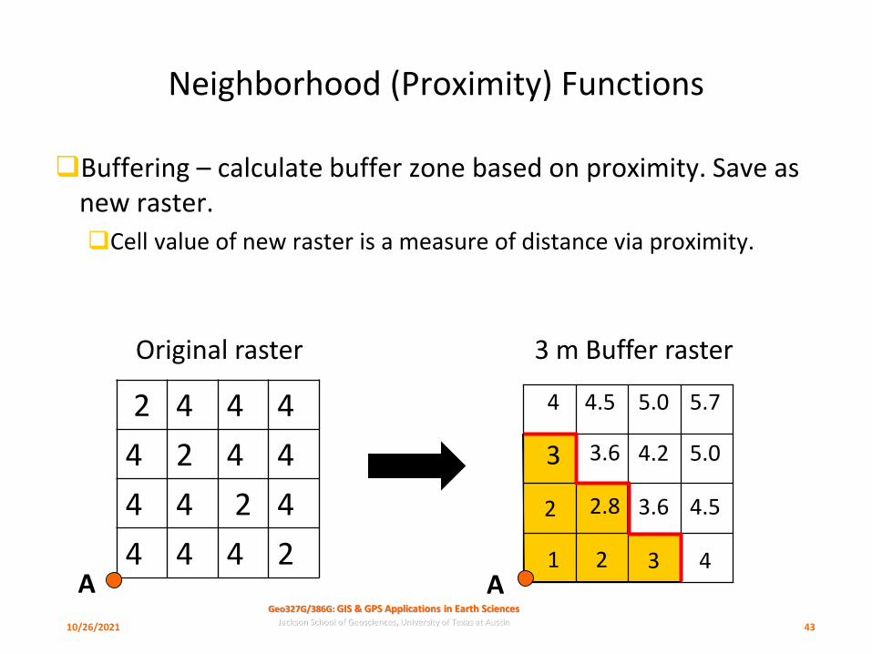
Neighborhood (Proximity) Functions
❑Buffering – calculate buffer zone based on proximity. Save as new raster.
❑Cell value of new raster is a measure of distance via proximity.
1A
2
3
4
2
2.8
3.6
4.5
3
3.6
4.2
5.0
4
4.5
5.0
5.72 4 4 4
4 2 4 4
4 4 2 4
4 4 4 2
3 m Buffer raster
A
Original raster
10/26/2021 43
Recommended