LAND-USE PLANNING TABLE DEFINITIONS FOUNDATION AND EXCAVATION The terms "earth" and "rock" excavation are used in the engineering sense; earth can be excavated by hand tools, whereas rock requires heavy equipment or blasting to remove. LIMITATIONS Slight—A slight limitation is one that commonly requires some corrective measure but can be overcome without a great deal of difficulty or expense. Moderate—A moderate limitation is one that can normally be overcome but the difficulty and expense are great enough that completing the project is commonly a question of feasibility. Severe—A severe limitation is one that is difficult to overcome and commonly is not feasible because of the expense involved. LAND USES Septic tank disposal system—A septic tank disposal system consists of a septic tank and a filter field. The filter field is a subsurface tile system laid in such a way that effluent from the septic tank is distributed with reasonable uniformity into the soil. Residences—Ratings are made for residences with basements because the degree of limitation is dependent upon ease and required depth of excavation. For example, excavation in limestone has greater limitation than excavation in shale for a house with a basement. Highways and streets—Refers to paved roads in which cuts and fills are made in hilly topography, and considerable work is done preparing subgrades and bases before the surface is applied. Access roads—These are low-cost roads, driveways, etc., usually surfaced with crushed stone or a thin layer of blacktop. A minimum of cuts and fills are made, little work is done preparing a subgrade, and generally only a thin base is used. The degree of limitation is based on year-around use and would be less severe if not used during the winter and early spring. Some types of recreation areas would not be used during these seasons. Light industry and malls—Ratings are based on developments having structures or equivalent load limit requirements of three stories or less, and large paved areas for parking lots. Structures with greater load limit requirements would normally need footings in solid rock, and the rock would need to be core drilled to determine the presence of caverns, cracks, etc. Intensive recreation—Athletic fields, stadiums, etc. Extensive recreation—Camp sites, picnic areas, parks, etc. Reservoir areas—The floor of the area where the water is impounded. Ratings are based on the permeability of the rock. Reservoir embankments—The rocks are rated on limitations for embankment material. Underground utilities—Included in this group are sanitary sewers, storm sewers, water mains, and other pipes that require fairly deep trenches.
Additional Resources Listed below are Web sites for several agencies and organizations that may be of assistance with land-use planning issues in Nicholas County: ces.ca.uky.edu/nicholas/ University of Kentucky Cooperative Extension Service www.bgadd.org/counties/nicholas.htm Nicholas County information from the Bluegrass Area Development District www.thinkkentucky.com/edis/cmnty/cw106/ Kentucky Economic Development Information System www.uky.edu/KentuckyAtlas/21181.html Kentucky Atlas and Gazetteer, Nicholas County quickfacts.census.gov/qfd/states/21/21181.html U.S. census data kgsweb.uky.edu/download/kgsplanning.htm Planning information from the Kentucky Geological Survey
Swelling and Shrinking Shales A problem of considerable concern in this area is the swelling of some of the clay minerals in shale units 2 and 3. Expanding shale can cause backfill to swell and concrete to crack and crumble. It can heave the foundation, the slab, and interior partitions resting on it, and damage upper floors and interior partitions. This phenomenon has been responsible for extensive damage to schools, homes, and businesses in Kentucky. During times of drought, these same shales may shrink, causing foundations to drop. Anyone planning construction on these shales should seek professional advice from a geologist or engineer familiar with the problem.
Geology of Kentucky
Learn more about Kentucky geology at www.uky.edu/KGS/geoky/
"
" "
"
"
"
"
"
"
"
" " Corbin
Paducah
Ashland
Somerset
OwensboroLexington
Frankfort
Covington
Louisville
HopkinsvilleBowling Green
Middlesboro
-82°
-82°
-83°
-83°
-84°
-84°
-85°
-85°
-86°
-86°
-87°
-87°
-88°
-88°
-89°
-89°-90°
39° 39°
38° 38°
37° 37°
Faults
LEGEND
TERTIARY/CRETACEOUS: sand, clayALLUVIUM: silt, clay, sand, gravel
PENNSYLVANIAN: shale, sandstone, coalMISSISSIPPIAN: shale, limestone, sandstoneDEVONIAN: shale, limestone
ORDOVICIAN: limestone, shaleSILURIAN: dolomite, shale
0 40 8020 Miles
Kentucky Geological SurveyJames C. Cobb, State Geologist and DirectorUNIVERSITY OF KENTUCKY, LEXINGTON
Slope Failure Mass movements or landslides of surficial materials are by far the most frequent and costly geologic hazards in the northern Kentucky area. Northern Kentucky has the greatest monetary loss per capita caused by landslides in the country. The failure of the slope may be rapid, but more commonly is a slow, almost imperceptible movement, called creep, of a few inches per year. Whether rapid or slow, the end results and damage are similar and costly: broken plumbing, cracked walls and foundations, cracked streets and sidewalks, and commonly total loss of the structures. Virtually all of the mass movements in northern Kentucky occur in colluvium—the weathered soil and rock materials that crumble from the bedrock as it weathers. The lower slopes of unit 2 are commonly thickly mantled with colluvium. Shales of unit 2 and adjacent unit 3 will break down and weather rapidly when exposed to air and water. These shaly units tend to swell considerably when exposed to water. For this reason, plumbing trenches under walls and foundations should be prevented from accumulating water. Units 2 and 3 may share a translational landslide. Gravity is the main driving force, but water nearly always plays a critical role by adding weight and lubricating the particles in the colluvium. Cutting into or overloading a slope with structures and fill can also be major contributing factors. Precautions include taking care of all surface-water runoff by making certain that all runoff from roofs, gutters, patios, sidewalks, and driveways is carried well away from and not toward the house; diverting drainage from areas sloping toward the house; cutting into natural slopes as little as possible and avoiding the use of fill; and trying to place the foundation of the structure on undisturbed bedrock. When in doubt, consult an engineering geologist or a geotechnical engineer. Old landslides can also be easily reactivated. Look for unusual bulges or cracks in the slope, tilted or curved trees, springs coming out onto the hillside, and tilted and cracked sidewalks, streets, and retaining walls. For more information, see Potter (1996).
Copyright 2006 by the University of Kentucky, Kentucky Geological SurveyFor information on obtaining copies of this map and other Kentucky Geolog-ical Survey maps and publications call our Public Information Center at 859.257.3896 or 877.778.7827 (toll free)View the KGS World Wide Web site at: www.uky.edu/kgs
NICHOLASCOUNTY
Colluvium can be less than 6 feet thick. Anadditional load may sit for years before con-ditions are right and the ground slides quickly.
Glide plane
Shale,limestone
Cliff
A transitional landslide is a relatively thin sheet of colluvium that separates from the underlying bedrock and slides catastrophically downslope more or less as a coherent sheet until it abruptly stops and becomes a crumbled, disorganized pile of debris. Such failures are common on steeper slopes of shale-dominated units (units 2, 3) when both colluvium and the weathered, more permeable bedrock below become fully saturated with water. After Potter (1996).
Movement is likely to be slow, but can beaccelerated by an increased load or anexcessive increase of water.
Cliff
Glide plane
Small tension cracks
Rotational landslides occur in both the thicker colluvium of unit 2 and in glacial deposits. The head or top area has tension cracks or small cliffs; the toe or bottom has transverse ridges or bulges. A principal glide plane connects the top to the bottom. Small tension cracks in the top become large scarps or cliffs as material moves downslope and small bulges in the bottom become larger ones. After Potter (1996).
Ground shaking (peak particle accelerations) caused by an earthquake in or near the county is minimal for structures situated on or tied into the bedrock foundation. In areas underlain by poorly consolidated soils, site-specific investigations should be conducted to assure that the building codes will conform to any ground deformation such as liquefication, landslides, or surface fault ruptures. Seewww.uky.edu/KGS/geologichazards/eqhazards.htm for more information.
Earthquake Hazard
$+
$+
$+
$+
$+
$+
$+$+
$+$+
$+
$+
$+
$+
")
")
")")")
")
")
")")
")
")
")")")
")")")")")")
")
")
")
")")
")")
")
")
")")")
")")")
")
")
")
")
")
")
")
")
")
")
")
")
")
")
A
AA
<<<¢¢<
<
<<<<
<<<
<
<
<<
<
<
<
<
¢¢¢
<
<
<<
<<
<
<<
<
<<
¢¢ <<
<<<
<<
<<
<<<
<
<
<<
<
¢¢¢¢¢
<¢¢
<¢¢
¢¢¢<
¢¢< << ¢< ¢<<<<< < <¢<
¢
< <<<
¢¢¢¢<
< ¢¢
<
<
< <
<
¢
<< ¢¢
¢<
¢¢ <<<
¢¢¢
¢¢
<
¢¢<
¢
<
<
¢<<<
¢ <<¢
<
!(
!(!(
!(
!(
!(
!(
nn
QR32
£¤68
£¤68QR32
QR13
QR36
QR32
ST1244
ST1244Harriso
n Coun
ty
Bourbon County
Clay Wildlife Management Area
Fleming County
Robertson County
Bath Coun
ty
Licking
ST1244
Beaver
Creek
Painter Cr
Sugar Cr
West Bran
ch
Suga
r Cr
East Bran
ch
Buchanan Cr
Fleming Cr
Scru
bgras
s Cr
Some
rset
Cree
k
E Fork Somerset Cr
N Fo
rk S
omer
set C
r
McBrides Run
Big Brushy Cr
Brushy Fork
Hooktown Br
Beaver Cr
Little
NCHS
NCES
Lake Carnico
ST1285
ST3316
ST1244
ST1658
ST1455ST1298
ST3314
ST3315
ST1198
ST1455
QR928
QR36
QR386
QR606
QR57QR13
QR648
QR32
QR392
QR57
QR36
QR32
£¤68
CARLISLE
Myers
Weston
Sprout
Milltown
Hooktown
Barefoot
East Union
Moorefield
Ellisville
Barterville
Headquarters
Morning Glory
Pleasant Valley
Upper Blue Licks
800
600
800
800
800
800
800
800
800
800
1000
800
800
800
800
600
600
800
1000 80
0
800
1000
800
800
800
800
800
600
800
800
800
1000
800
800
800
1000
800
800
800
800
800
800
800
800
1000
1000
800 800
1000
1000
800
1000
800
800
1000
600
600
1000
800
800
800
800
800
800
1000
800
1000
1000
800
800
800
600
1000
800
800
1000
800
1000
1000
800
1000800
800
800
800
800
800
800
1000
800
Brushy Fork
Crooked Cr
McBrides Run
Stony
Cr
Cane Run
Wilbur Run
Brushy Cr
Taylors Cr
Big Br
Somerset Cr
Plank R
un
Goose Cr
Cassidy Cr
Jerdan Br
Mint Cr
Laysons Br
Fishtr
ap C
r
Hinkston Creek
Cass
idy Cr
Ston
y Cr
Brushy Cr
Licking River
Stony Cr Licking R
River
Lickin
g R
7
6
5
4
32
1
7.5-Minute Quadrangle Map Index
PIQUACOWAN
CARLISLE
SHERBURNE
MOOREFIELD
SHADY NOOK
SHARPSBURG
MILLERSBURG
NORTH
MIDDLETOWN
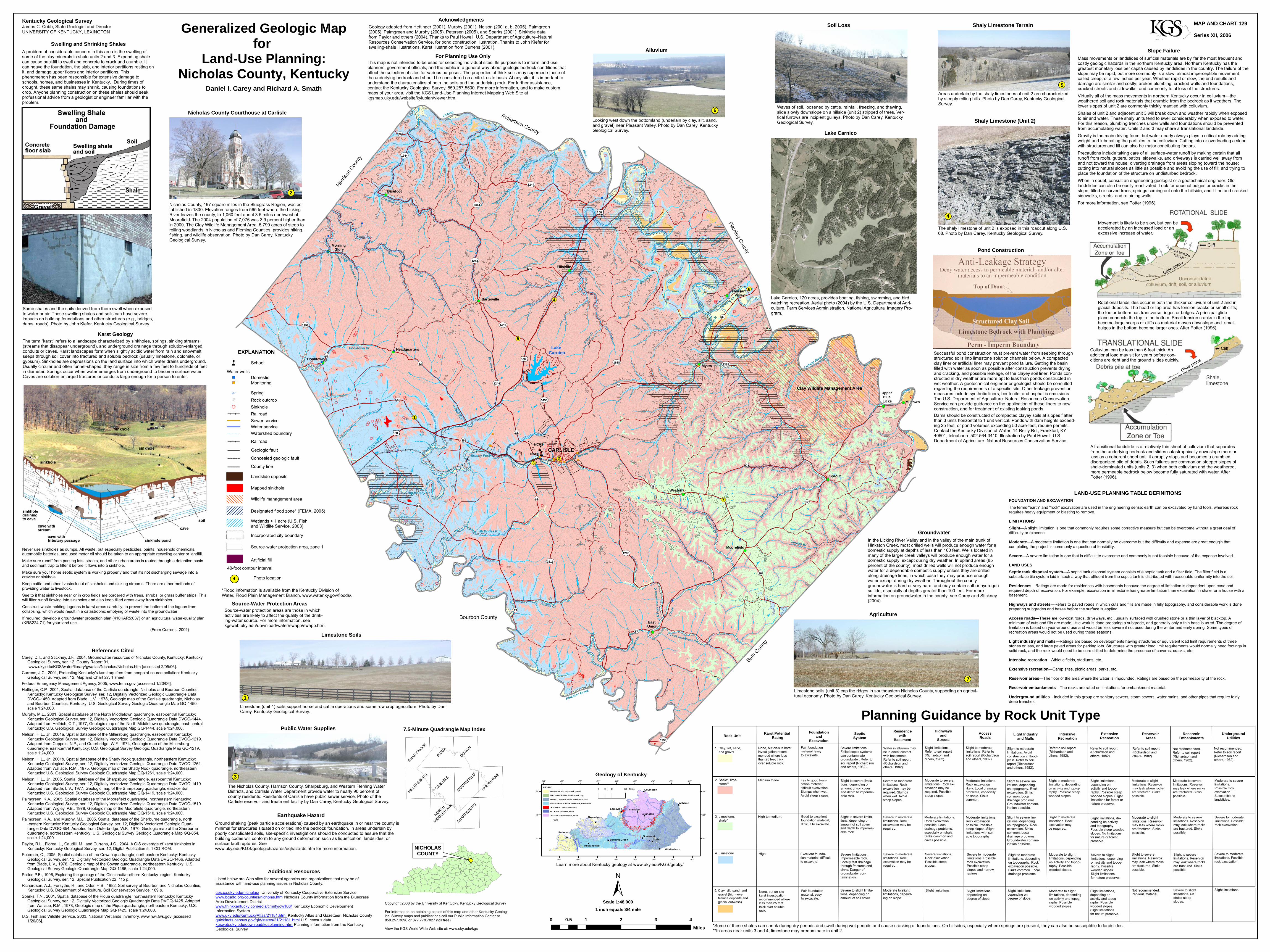
Groundwater In the Licking River Valley and in the valley of the main trunk of Hinkston Creek, most drilled wells will produce enough water for a domestic supply at depths of less than 100 feet. Wells located in many of the larger creek valleys will produce enough water for a domestic supply, except during dry weather. In upland areas (85 percent of the county), most drilled wells will not produce enough water for a dependable domestic supply unless they are drilled along drainage lines, in which case they may produce enough water except during dry weather. Throughout the county groundwater is hard or very hard, and may contain salt or hydrogen sulfide, especially at depths greater than 100 feet. For more information on groundwater in the county, see Carey and Stickney (2004).
Generalized Geologic Mapfor
Land-Use Planning:Nicholas County, Kentucky
Daniel I. Carey and Richard A. Smath
Never use sinkholes as dumps. All waste, but especially pesticides, paints, household chemicals, automobile batteries, and used motor oil should be taken to an appropriate recycling center or landfill. Make sure runoff from parking lots, streets, and other urban areas is routed through a detention basin and sediment trap to filter it before it flows into a sinkhole. Make sure your home septic system is working properly and that it's not discharging sewage into a crevice or sinkhole. Keep cattle and other livestock out of sinkholes and sinking streams. There are other methods of providing water to livestock. See to it that sinkholes near or in crop fields are bordered with trees, shrubs, or grass buffer strips. This will filter runoff flowing into sinkholes and also keep tilled areas away from sinkholes. Construct waste-holding lagoons in karst areas carefully, to prevent the bottom of the lagoon from collapsing, which would result in a catastrophic emptying of waste into the groundwater. If required, develop a groundwater protection plan (410KAR5:037) or an agricultural water-quality plan (KRS224.71) for your land use. (From Currens, 2001)
*Some of these shales can shrink during dry periods and swell during wet periods and cause cracking of foundations. On hillsides, especially where springs are present, they can also be susceptible to landslides.**In areas near units 3 and 4, limestone may predominate in unit 2.
Foundationand
ExcavationSepticSystem
Residencewith
BasementHighways
andStreets
AccessRoads Light Industry
and MallsIntensive
RecreationExtensiveRecreation
ReservoirAreas
ReservoirEmbankments
UndergroundUtilities
Severe limitations. Failed septic systems can contaminate groundwater. Refer to soil report (Richardsonand others, 1982).
Water in alluvium may be in direct contact with basements. Refer to soil report (Richardson and others, 1982).
Slight limitations.Refer to soil report (Richardson and others, 1982).
Slight to moderate limitations. Avoid construction in flood-plain. Refer to soil report (Richardsonand others, 1982).
Refer to soil report (Richardson and others, 1982).
Not recommended.Refer to soil report (Richardson and others, 1982).
Fair to good foun-dation material; difficult excavation.Slumps when wet. Avoid steep slopes.
Severe to moderate limitations. Rock excavation may berequired. Slumpswhen wet. Avoidsteep slopes.
Moderate limitations. Rock excavation likely. Local drainage problems, especially on shale. Sinks common.
Slight to severe lim-itations, depending on topography. Rock excavation. Sinks common. Local drainage problems. Groundwater contam-ination possible.
Slight to moderate limitations, depending on activity and topog-raphy. Possible steep wooded slopes.
Slight to severe limita-tions, depending on amount of soil cover and depth to imperme-able rock.
Moderate to slightlimitations. Reservoir may leak where rocks are fractured. Sinks possible.
Severe to moderate limitations. Possible rock excavation.
Excellent founda-tion material; difficult to excavate.
Severe to moderate limitations. Possiblerock excavation.Possible steepslopes and narrowravines.
Slight to moderatelimitations, depending on topography. Rock excavation possible. Sinks common. Local drainage problems.
Severe to slightlimitations, depending on activity and topog-raphy. Possible wooded slopes.Slight limitations for nature preserve.
Planning Guidance by Rock Unit TypeKarst Potential
Rating
None, but on-site karst investigation recom-mended where less than 25 feet thick over soluble rock.
Medium to low.
High to medium. Good to excellentfoundation material;difficult to excavate.
Fair foundation material; easy to excavate.
Slight to moderatelimitations. Refer to soil report (Richardsonand others, 1982).
Not recommended.Refer to soil report (Richardson and others, 1982).
Moderate to severelimitations. Rock ex-cavation may be required. Possible steep slopes.
Slight limitations, depending on activity and topog-raphy. Possible steep wooded slopes. Slight limitations for forest or nature preserve.
Severe to moderate limitations. Rock excavation may berequired.
Moderate limitations. Rock excavation possible. Local drainage problems,especially on shale.Sinks common andcaves possible.
Moderate limitations. Rock excavationpossible. Possiblesteep slopes. Slight limitations with suit-able topography.
Slight to severe lim-itations, depending on topography. Rock excavation. Sinks common. Local drainage problems. Groundwater contam-ination possible.
Slight to moderatelimitations. Rockexcavation maybe required.
Slight limitations, de-pending on activity and topography. Possible steep wooded slopes. No limitationsfor nature or forest preserve.
Moderate to severe limitations. Reservoir may leak where rocks are fractured. Sinks possible.
Moderate to severelimitations. Possible rock excavation.Susceptible to landslides.
Severe to moderate limitations. Possible rock excavation.
Slight to severelimitations. Reservoir may leak where rocks are fractured. Sinkspossible.
Moderate to slightlimitations, depending on activity and topog-raphy. Possible wooded slopes.
High.
Rock Unit
1. Clay, silt, sand, and gravel
2. Shale*, lime- stone**
4. Limestone
3. Limestone, shale*
5. Clay, silt, sand, and gravel (high-level terrace deposits and glacial outwash)
None, but on-site karst investigation recommended where less than 25 feet thick over soluble rock.
Fair foundation material; easy to excavate.
Severe to slight limita-tions, depending on amount of soil cover.
Moderate to slight limitations, depend-ing on slope.
Slight limitations. Slight limitations, depending on degree of slope.
Moderate to slightlimitations, depending on activity and topog-raphy. Possible wooded slopes.
Slight limitations, depending on activity and topog-raphy. Possible wooded slopes.Slight limitations for nature preserve.
Slight limitations. Severe to slight limitations. Un-stable steep slopes.
Not recommended.Pervious material.
Severe limitations.Impermeable rock. Locally fast drainage through fractures andsinks. Danger of groundwater con-tamination.
Severe to moderate limitations. Rock excavation may berequired.
Severe limitations. Rock excavation.Possible steepslopes.
Slight to severelimitations. Reservoir may leak where rocks are fractured. Sinkspossible.
Slight to severe limita-tions, depending on amount of soil cover and depth to imperme-able rock.
Refer to soil report (Richardson and others, 1982).
Refer to soil report (Richardson and others, 1982).
Slight limitations, depending on degree of slope.
Moderate to slightlimitations. Reservoir may leak where rocks are fractured. Sinks possible.
Moderate to severe limitations. Reservoir may leak where rocks are fractured. Sinks possible.
The term "karst" refers to a landscape characterized by sinkholes, springs, sinking streams (streams that disappear underground), and underground drainage through solution-enlarged conduits or caves. Karst landscapes form when slightly acidic water from rain and snowmelt seeps through soil cover into fractured and soluble bedrock (usually limestone, dolomite, or gypsum). Sinkholes are depressions on the land surface into which water drains underground. Usually circular and often funnel-shaped, they range in size from a few feet to hundreds of feet in diameter. Springs occur when water emerges from underground to become surface water. Caves are solution-enlarged fractures or conduits large enough for a person to enter.
Karst Geology
This map is not intended to be used for selecting individual sites. Its purpose is to inform land-use planners, government officials, and the public in a general way about geologic bedrock conditions that affect the selection of sites for various purposes. The properties of thick soils may supercede those of the underlying bedrock and should be considered on a site-to-site basis. At any site, it is important to understand the characteristics of both the soils and the underlying rock. For further assistance, contact the Kentucky Geological Survey, 859.257.5500. For more information, and to make custom maps of your area, visit the KGS Land-Use Planning Internet Mapping Web Site at kgsmap.uky.edu/website/kyluplan/viewer.htm.
For Planning Use Only
Geology adapted from Hettinger (2001), Murphy (2001), Nelson (2001a, b, 2005), Palmgreen (2005), Palmgreen and Murphy (2005), Petersen (2005), and Sparks (2001). Sinkhole data from Paylor and others (2004). Thanks to Paul Howell, U.S. Department of Agriculture–Natural Resources Conservation Service, for pond construction illustration. Thanks to John Kiefer for swelling-shale illustrations. Karst illustration from Currens (2001).
Acknowledgments
Successful pond construction must prevent water from seeping throughstructured soils into limestone solution channels below. A compactedclay liner or artificial liner may prevent pond failure. Getting the basin filled with water as soon as possible after construction prevents drying and cracking, and possible leakage, of the clayey soil liner. Ponds con-structed in dry weather are more apt to leak than ponds constructed in wet weather. A geotechnical engineer or geologist should be consulted regarding the requirements of a specific site. Other leakage prevention measures include synthetic liners, bentonite, and asphaltic emulsions. The U.S. Department of Agriculture–Natural Resources Conservation Service can provide guidance on the application of these liners to new construction, and for treatment of existing leaking ponds.Dams should be constructed of compacted clayey soils at slopes flatter than 3 units horizontal to 1 unit vertical. Ponds with dam heights exceed-ing 25 feet, or pond volumes exceeding 50 acre-feet, require permits. Contact the Kentucky Division of Water, 14 Reilly Rd., Frankfort, KY 40601, telephone: 502.564.3410. Illustration by Paul Howell, U.S.Department of Agriculture–Natural Resources Conservation Service.
Pond Construction
MAP AND CHART 129Series XII, 2006
Lake Carnico
Lake Carnico, 120 acres, provides boating, fishing, swimming, and bird watching recreation. Aerial photo (2004) by the U.S. Department of Agri-culture, Farm Services Administration, National Agricultural Imagery Pro-gram.
Carey, D.I., and Stickney, J.F., 2004, Groundwater resources of Nicholas County, Kentucky: Kentucky Geological Survey, ser. 12, County Report 91, www.uky.edu/KGS/water/library/gwatlas/Nicholas/Nicholas.htm [accessed 2/05/06].Currens, J.C., 2001, Protecting Kentucky's karst aquifers from nonpoint-source pollution: Kentucky Geological Survey, ser. 12, Map and Chart 27, 1 sheet.Federal Emergency Management Agency, 2005, www.fema.gov [accessed 1/20/06].Hettinger, C.P., 2001, Spatial database of the Carlisle quadrangle, Nicholas and Bourbon Counties, Kentucky: Kentucky Geological Survey, ser. 12, Digitally Vectorized Geologic Quadrangle Data DVGQ-1450. Adapted from Blade, L.V., 1978, Geologic map of the Carlisle quadrangle, Nicholas and Bourbon Counties, Kentucky: U.S. Geological Survey Geologic Quadrangle Map GQ-1450, scale 1:24,000.Murphy, M.L., 2001, Spatial database of the North Middletown quadrangle, east-central Kentucky: Kentucky Geological Survey, ser. 12, Digitally Vectorized Geologic Quadrangle Data DVGQ-1444. Adapted from Helfrich, C.T., 1977, Geologic map of the North Middletown quadrangle, east-central Kentucky: U.S. Geological Survey Geologic Quadrangle Map GQ-1444, scale 1:24,000.Nelson, H.L., Jr., 2001a, Spatial database of the Millersburg quadrangle, east-central Kentucky: Kentucky Geological Survey, ser. 12, Digitally Vectorized Geologic Quadrangle Data DVGQ-1219. Adapted from Cuppels, N.P., and Outerbridge, W.F., 1974, Geologic map of the Millersburg quadrangle, east-central Kentucky: U.S. Geological Survey Geologic Quadrangle Map GQ-1219, scale 1:24,000.Nelson, H.L., Jr., 2001b, Spatial database of the Shady Nook quadrangle, northeastern Kentucky: Kentucky Geological Survey, ser. 12, Digitally Vectorized Geologic Quadrangle Data DVGQ-1261. Adapted from Wallace, R.M., 1975, Geologic map of the Shady Nook quadrangle, northeastern Kentucky: U.S. Geological Survey Geologic Quadrangle Map GQ-1261, scale 1:24,000.Nelson, H.L., Jr., 2005, Spatial database of the Sharpsburg quadrangle, east-central Kentucky: Kentucky Geological Survey, ser. 12, Digitally Vectorized Geologic Quadrangle Data DVGQ-1419. Adapted from Blade, L.V., 1977, Geologic map of the Sharpsburg quadrangle, east-central Kentucky: U.S. Geological Survey Geologic Quadrangle Map GQ-1419, scale 1:24,000.Palmgreen, K.A., 2005, Spatial database of the Moorefield quadrangle, northeastern Kentucky: Kentucky Geological Survey, ser. 12, Digitally Vectorized Geologic Quadrangle Data DVGQ-1510. Adapted from Wigley, P.B., 1978, Geologic map of the Moorefield quadrangle, northeastern Kentucky: U.S. Geological Survey Geologic Quadrangle Map GQ-1510, scale 1:24,000.Palmgreen, K.A., and Murphy, M.L., 2005, Spatial database of the Sherburne quadrangle, north -eastern Kentucky: Kentucky Geological Survey, ser. 12, Digitally Vectorized Geologic Quad- rangle Data DVGQ-854. Adapted from Outerbridge, W.F., 1970, Geologic map of the Sherburne quadrangle, northeastern Kentucky: U.S. Geological Survey Geologic Quadrangle Map GQ-854, scale 1:24,000.Paylor, R.L., Florea, L., Caudill, M., and Currens, J.C., 2004, A GIS coverage of karst sinkholes in Kentucky: Kentucky Geological Survey, ser. 12, Digital Publication 5, 1 CD-ROM.Petersen, C., 2005, Spatial database of the Cowan quadrangle, northeastern Kentucky: Kentucky Geological Survey, ser. 12, Digitally Vectorized Geologic Quadrangle Data DVGQ-1466. Adapted from Blade, L.V., 1978, Geologic map of the Cowan quadrangle, northeastern Kentucky: U.S. Geological Survey Geologic Quadrangle Map GQ-1466, scale 1:24,000.Potter, P.E., 1996, Exploring the geology of the Cincinnati/northern Kentucky region: Kentucky Geological Survey, ser. 12, Special Publication 22, 115 p. Richardson, A.J., Forsythe, R., and Odor, H.B., 1982, Soil survey of Bourbon and Nicholas Counties, Kentucky: U.S. Department of Agriculture, Soil Conservation Service, 109 p.Sparks, T.N., 2001, Spatial database of the Piqua quadrangle, northeastern Kentucky: Kentucky Geological Survey, ser. 12, Digitally Vectorized Geologic Quadrangle Data DVGQ-1425. Adapted from Wallace, R.M., 1978, Geologic map of the Piqua quadrangle, northeastern Kentucky: U.S. Geological Survey Geologic Quadrangle Map GQ-1425, scale 1:24,000.U.S. Fish and Wildlife Service, 2003, National Wetlands Inventory, www.nwi.fws.gov [accessed 1/20/06].
References Cited
Public Water Supplies
The Nicholas County, Harrison County, Sharpsburg, and Western Fleming Water Districts, and Carlisle Water Department provide water to nearly 90 percent of county residents. Residents of Carlisle have public sewer service. Photo of the Carlisle reservoir and treatment facility by Dan Carey, Kentucky Geological Survey.
3
Limestone Soils
Limestone (unit 4) soils support horse and cattle operations and some row crop agriculture. Photo by Dan Carey, Kentucky Geological Survey.
1
Nicholas County, 197 square miles in the Bluegrass Region, was es-tablished in 1800. Elevation ranges from 565 feet where the LickingRiver leaves the county, to 1,060 feet about 3.5 miles northwest of Moorefield. The 2004 population of 7,076 was 3.9 percent higher thanin 2000. The Clay Wildlife Management Area, 5,790 acres of steep to rolling woodlands in Nicholas and Fleming Counties, provides hiking, fishing, and wildlife observation. Photo by Dan Carey, Kentucky Geological Survey.
Nicholas County Courthouse at Carlisle
2
Some shales and the soils derived from them swell when exposedto water or air. These swelling shales and soils can have severe impacts on building foundations and other structures (e.g., bridges,dams, roads). Photo by John Kiefer, Kentucky Geological Survey.
Alluvium
Looking west down the bottomland (underlain by clay, silt, sand, and gravel) near Pleasant Valley. Photo by Dan Carey, Kentucky Geological Survey.
6
Soil Loss
Waves of soil, loosened by cattle, rainfall, freezing, and thawing, slide slowly downslope on a hillside (unit 2) stripped of trees. Ver-tical furrows are incipient gulleys. Photo by Dan Carey, Kentucky Geological Survey.
Shaly Limestone Terrain
Areas underlain by the shaly limestones of unit 2 are characterized by steeply rolling hills. Photo by Dan Carey, Kentucky Geological Survey.
5
Shaly Limestone (Unit 2)
The shaly limestone of unit 2 is exposed in this roadcut along U.S. 68. Photo by Dan Carey, Kentucky Geological Survey.
4
Agriculture
Limestone soils (unit 3) cap the ridges in southeastern Nicholas County, supporting an agricul-tural economy. Photo by Dan Carey, Kentucky Geological Survey.
7
±Scale 1:48,000
0 1 2 3 40.5Miles
1 inch equals 3/4 mile
Source-water protection areas are those in which activities are likely to affect the quality of the drink-ing-water source. For more information, see kgsweb.uky.edu/download/water/swapp/swapp.htm.
Source-Water Protection Areas
Photo location
EXPLANATION
Water wells
MonitoringSpring
Wetlands > 1 acre (U.S. Fish and Wildlife Service, 2003)Incorporated city boundary
Artificial fill40-foot contour interval
Source-water protection area, zone 1
4
")
Domestic")
A
Watershed boundary
Designated flood zone* (FEMA, 2005)
Railroad
Mapped sinkhole
County line
Geologic fault
Wildlife management area
Concealed geologic fault
Rock outcropSinkholeRailroadSewer serviceWater service
¢
<
Landslide deposits
*Flood information is available from the Kentucky Division of Water, Flood Plain Management Branch, www.water.ky.gov/floods/.
Schooln
Recommended