Folkert Boersma
Reducing errors in using tropospheric Reducing errors in using tropospheric NONO22 columns observed from space columns observed from space

What is so uncertain about emissions?• quantities• locations• times• trends
Main use of satellite observations: estimating emissions of NOx
But we can see the NOx sources from space
Emissions
EMEP
SCIAMACHY
Blond et al. (2007)
chem= 4-24 hrs
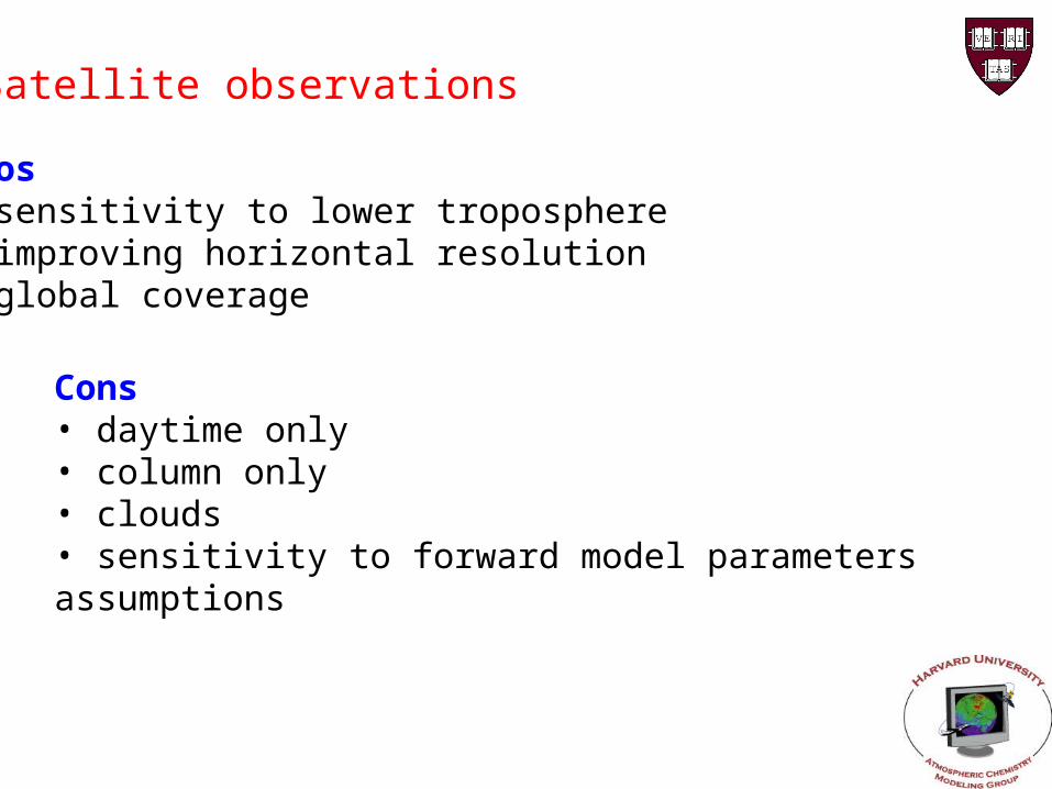
Pros• sensitivity to lower troposphere• improving horizontal resolution• global coverage
Satellite observations
Cons• daytime only• column only• clouds• sensitivity to forward model parameters assumptions

Retrieval method

3-step procedure• obtain slant column along average light path• separate stratospheric and tropospheric contributions • convert tropospheric slant column in vertical column
Retrieval method
In equation:
Ns, Ns,st, Mtr are all error sources

Retrieval method
aerosols
surface pressure

IUP Bremen Dalhousie KNMI/BIRA
Ns,st Ref. sector scaled to SLIMCAT strat.
Ref. Sector Data-assimilation in TM4
Cloud fraction FRESCO <0.2 cloud fraction; only cloud selection, no further correction
GOMECAT FRESCO
Cloud pressure Not used GOMECAT FRESCO
Albedo GOME GOME TOMS/GOME
Profile shape MOZART-2 run for 1997, monthly averages on 2.8 x 2.8 °
GEOS-Chem (2x2.5)
TM4 (3x2)
Temperature correction
No Based on U.S. std. atmosphere
Based on ECMWF T-profiles
Aerosols Based on LOWTRAN
Based on GEOS-Chem
No
‘State-of-science’ van Noije et al., ACP, 6, 2943-2979, 2006

Systematic differences
van Noije et al., ACP, 6, 2943-2979, 2006

Accounting for zonal variability or not?
E. J. Bucsela – NASA GSFC
41.5°N
Stratospheric column
Model information
Reference Sector

Without correction errors up to 11015 molec.cm-2
Stratospheric column
March 1997

Alternative: limb-nadir matching
• Limb observes zonal variability
• Stratospheric column estimate may introduce offsets from limb-technique
Courtesy of E. J. Bucsela – NASA GSFC
Stratospheric column
A. Richter et al.– IUP Bremen

Stratospheric column
In summary
• Reference sector method questionable
• Assimilation & nadir-limb correct known systematic errors
• Assimilation self-consistent; uncertainty ~0.2×10¹⁵
• Validation needed
- SAOZ network (sunrise, sunset)
- Brewer direct sun (Cede et al.) in unpolluted areas

Retrieval method
Tropospheric air mass factor Mtr - Computed with radiative transfer model and stored in tables
Mtr = f(xa,b)
xa = a priori tropospheric NO2 prf
b = forward model parameters
- cloud fraction
- cloud pressure
- surface albedo
- aerosols
( - viewing geometry)
Air mass factor
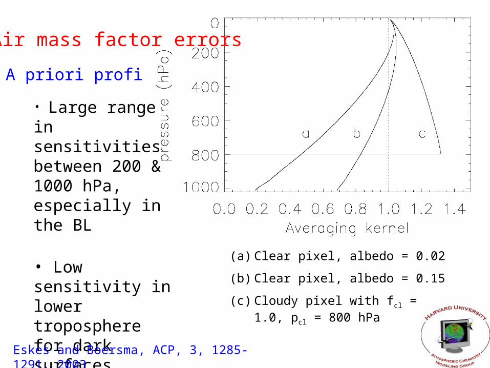
A priori profile
(a) Clear pixel, albedo = 0.02
(b) Clear pixel, albedo = 0.15
(c) Cloudy pixel with fcl = 1.0, pcl = 800 hPa
Air mass factor errors
• Large range in sensitivities between 200 & 1000 hPa, especially in the BL
• Low sensitivity in lower troposphere for dark surfaces
Eskes and Boersma, ACP, 3, 1285-1291, 2003

A priori profile from CTMs
Air mass factor errors
• Shapes reasonably captured by CTMs
• Effect of model assumptions on BL mixing lead to errors <10-15%
• Models are coarse relative to latest retrievals
Martin et al., JGR, 109, D24307, 2004
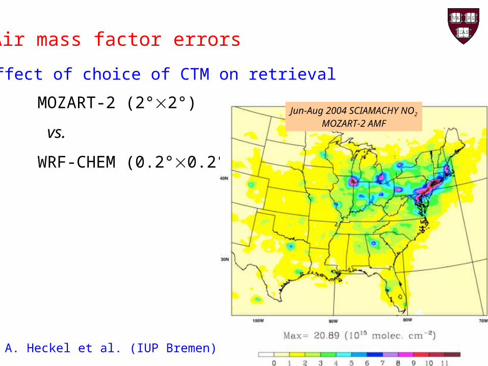
Effect of choice of CTM on retrieval
Air mass factor errors
MOZART-2 (2°2°)
vs.
WRF-CHEM (0.2°0.2°)
Jun-Aug 2004 SCIAMACHY NO2
MOZART-2 AMF
A. Heckel et al. (IUP Bremen)

Effect of choice of CTM on retrieval
Air mass factor errors
Effect ~10%Jun-Aug 2004 SCIAMACHY NO2
WRF-Chem AMF
A. Heckel et al. (IUP Bremen)

Cloud fraction
Albedo
Cloud pressure
Air mass factor sensitivities
M = wMcl + (1-w)Mcr
Boersma et al., JGR, 109, D04311, 2004

M = M/asf asf
asf = 0.02 (GOME-TOMS)
AMF errors – surface albedo
(%)
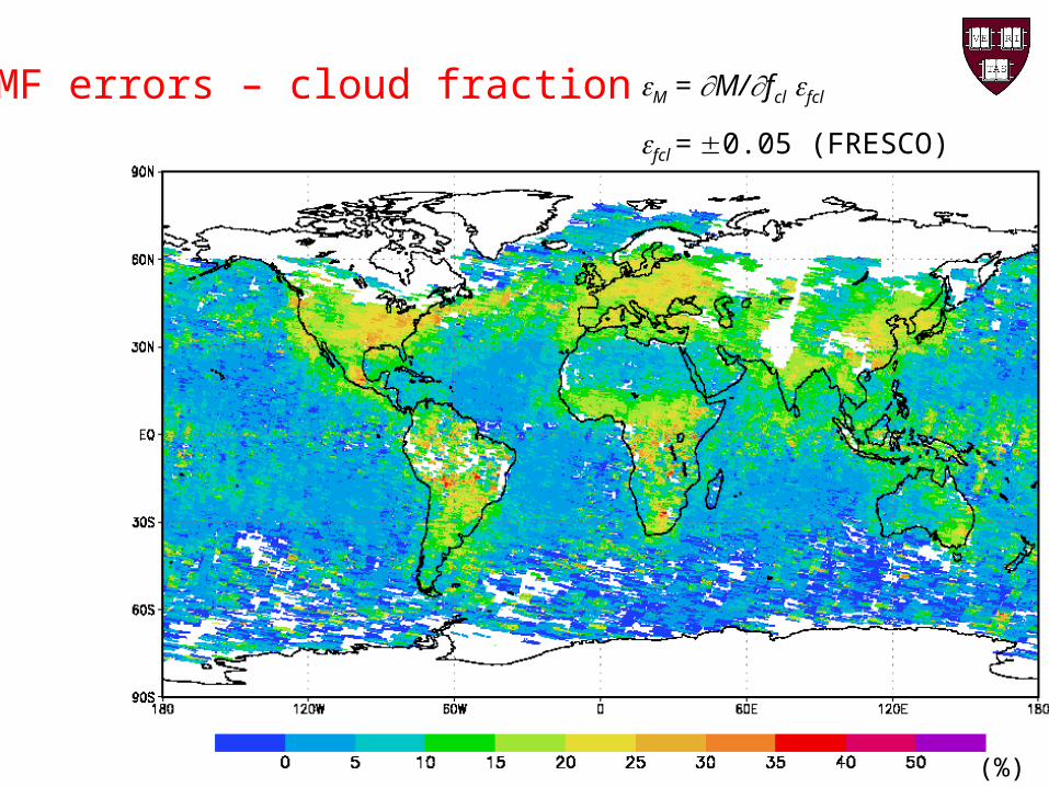
M = M/fcl fcl
fcl = 0.05 (FRESCO)
AMF errors – cloud fraction
(%)

M = M/pcl pcl
pcl = 50.0 (FRESCO)
AMF errors – cloud pressure
(%)

• If NO2 present, then also aerosol• Aerosols affect radiative transfer dep. on particle type
Air mass factor errors - aerosols
Martin et al., JGR, 108, 4537, 2003

• Aerosols affect radiative transfer• Cloud fraction sensitive to aerosols ( = +1.0 fcl +0.01)
Air mass factor errors - aerosols
Direct correction
Indirect correction through M=wMcl+(1-w)Mcr

Air mass factor errors – surface pressure
• Surface pressure from CTMs (2° × 3°)• Strong differences with hi-res surface pressures
GOME SCIAMACHY
Schaub et al., ACPD, 2007

Error top-10
1. Cloud fraction errors ~30%
2. Surface albedo ~15% + resolution effect?
3. Vertical profile ~10% + resolution effect?
4. Aerosols ~10%? More research needed
5. Cloud pressure ~5%
6. Surface pressure depends on orography
Is there a recipe for reducing all these errors?
1. Better estimates of forward model parameters
A good example: surface pressures (Schaub et al.)
What should be done:
- a validation/improvement of surface albedo databases
- a validation/improvement of cloud retrievals
- investigate effects aerosols on (cloud) retrievals
- validation vertical profiles
- higher spatial resolution (sfc. albedo, pressure, profile)

Is there a recipe for reducing all these errors?
2. How do we know if better forward model parameters improve retrievals?
We need an extensive, unambiguous and well-accessible validation database
Testbed for retrieval improvements:
- in situ aircraft NO2 (Heland, ICARTT, INTEX)
- surface columns (SAOZ, Brewer, (MAX)DOAS)
- in situ profiles (Schaub/Brunner)
- surface NO2 (regionally)

Is there a recipe for reducing all these errors?
3. Towards a common algorithm/reduced errors?
Difficult!
• Without testbed, verification of improvements is hard
• Improvements for one algorithm may deteriorate other algorithms, depending on retrieval assumptions
• Improved model parameters may work for some regions and some seasons, but not for others

Is there a recipe for reducing all these errors?
3. Towards a common algorithm/reduced errors?
Worth the try!
• Systematic differences can be reduced (emission estimates)
• Requires ‘scientific will’ – enormous task
- Collection of validation set
- Flexible algorithms digesting various model parameters
- Intercomparison leading to recommendations
- Fits purpose ACCENT/TROPOSAT
Recommended
![(1) Gligoric,Svetozar - Boersma,Paul (4) Boersma,Paul ...шахматистам.рф/Bases/Enz/B/BOERSMA/vse_pobedy_i_nichi.pdf · (1) Gligoric,Svetozar - Boersma,Paul [A56] Niemeyer](https://img.dokumen.tips/doc/110x75/5ab31def7f8b9ac3348dfa91/1-gligoricsvetozar-boersmapaul-4-boersmapaul-basesenzbboersmavsepobedyinichipdf1.jpg)