FLOOD FORECASTING AT KINABATANGAN RIVER, SABAH BY UTILIZING
ARTIFICIAL NEURAL NETWORK (ANN)
WAN NURULHAFIZAH BT ABD RAZAK
Report submitted in fulfillment of the requirements for the award of the degree of
Bachelor of Engineering (Hons.) in Civil Engineering
Faculty of civil Engineering and Earth Resources
UNIVERSITI MALAYSIA PAHANG
JUNE 2015

iv
ABSTRACT
Flood event is among the most influential disaster in Malaysia .Therefore, the developing
of flood forecasting model is to minimize the effects of flood and to achieve a model with
high accuracy by utilizing Artificial Neural Network (ANN). Artificial Neural Network is a
highly non-linear and can capture the complex interactions among input variables in a
system without any prior knowledge about the nature of these interactions. Nowadays,
ANN is widely used in prediction and forecasting in water resources. The area of study the
flood forecasting is carried out at the Balat Station, Kinabatangan River, Sabah where the
hourly water level data is collected from Department of Irrigation and Drainage (DID) from
year 2000 until 2014. The results indicated that the model develop a highest accuracy is 6
hour time interval for 4000 iteration where the NSC result is 0.996 with lower RMSE
155.341 compared to others iteration and time interval. This modal achieved 100% at
allowable error less than 500 mm which is show the prediction of water level. As a
conclusion, this model shows high accuracy and water level can be used alone. This can be
applied in the real world to give out warning on imminent flood.

v
ABSTRAK
Peristiwa banjir adalah antara bencana yang paling berpengaruh di Malaysia. Oleh itu,
membangunkan model ramalan banjir adalah salah satu cara bagi mengurangkan kesan
banjir dan mencapai model dengan ketepatan yang tinggi dengan menggunakan rangkaian
neural tiruan atau artificial neural network (ANN). ANN adalah tidak linear dan boleh
menangkap interaksi kompleks antara pembolehubah input dalam sistem tanpa apa-apa
pengetahuan terlebih dahulu tentang sifat interaksi ini. Pada masa kini, ANN digunakan
secara meluas dalam ramalan dan ramalan dalam sumber air. Kawasan kajian peramalan
banjir dijalankan di Stesen Balat, Kinabatangan River, Sabah di mana data paras air setiap
jam dikumpulkan daripada Jabatan Pengairan dan Saliran (JPS) dari tahun 2000 hingga
2014. Hasil kajian menunjukkan bahawa model membangunkan ketepatan tertinggi adalah
selang masa 6 jam untuk lelaran 4000 di mana hasil NSC ialah 0.996 dengan rendah RMSE
155.341 berbanding dengan lelaran serta selang masa yang lain. Modal ini mencapai 100%
pada kesilapan yang dibenarkan kurang daripada 500 mm yang menunjukkan ramalan paras
air. Kesimpulannya, model ini menunjukkan ketepatan yang tinggi dan boleh menggunakan
paras air sahaja. Ini juga boleh digunakan dalam dunia sebenar untuk memberi amaran pada
banjir yang akan berlaku

vi
TABLE OF CONTENTS
Page
SUPERVISOR’S DECLARATION i
STUDENT DECLARATION ii
ACKNOWLEDGEMENT iii
ABSTRACT iv
ABSTRAK v
TABLE OF CONTENTS vi
LIST OF FIGURES ix
LIST OF TABLES x
CHAPTER 1 INTRODUCTION 1
1.1 Background 1
1.2 Problems Statement 4
1.3 Objectives 4
1.4 Scope of Study 5
1.5 Research Significant 5

vii
CHAPTER 2 LITERATURE REVIEWS 6
2.1 Introduction 6
2.2 Water Cycle 7
2.2.1 Precipitation 7
2.2.2 Runoff 7
2.2.3 Process of Water Cycle 7
2.3 Types and Causes of Flood 8
2.4 Impacts of Flood 9
2.4.1 Impacts on Human 9
2.4.2 Impacts on Property and Infrastructure 9
2.4.3 Impacts on Environment 9
2.5 Flood Forecasting Malaysia 10
2.5.1 Flood Forecasting System 10
2.6 Artificial Neural Network (ANN) 12
CHAPTER 3 METHODOLOGY 14
3.1 Study Area and Data Collection 14
3.2 Artificial Neural Network 16
3.3 Modeling Method 17
3.4 Flow Chart 19

viii
CHAPTER 4 RESULTS AND DISCUSSION 20
4.1 1000 Iteration 20
4.1.1 3 Hours Time Interval 20
4.1.2 6 Hours Time Interval 23
4.2 4000 Iteration 26
4.2.1 3 Hours Time Interval 26
4.2.2 6 Hours Time Interval 29
4.3 Discussion 32
CHAPTER 5 CONCLUSIONS 33
REFERENCES 35
APPENDICES 36
A Approval Letter from Faculty 36
B Data Supply Form from DID 37

ix
LIST OF FIGURES
Figure. No Title Page
1.0 Flood Prone Areas in East Malaysia 2
1.1 Flooding In Kinabatangan, Sabah 3
2.0 Water Cycle 7
2.1 Classification of Water Level at Flood 11
Warning Centre, Malaysia
2.2 McCulloch Pitts Neuron (1943) 12
3.1 Kinabatangan River, Sabah (DID) 15
3.2 Water Level Elevation statuses at 15
Kinabatangan River Section
3.3 Neuron Scheme 16
3.4 Feed Forward Diagram 17
4.1 (a) Forecasting Performances Modal for 4-4-1 22
4.1 (b) Forecasting Performances Modal 23
4.2 (a) Forecasting Performances Modal for 6-6-1 24
4.2 (b) Forecasting Performance Modal 25
4.3(a) Forecasting Performances Model for 7-7-1 27
4.3(b) Forecasting Performance Model 28
4.4 (a) Forecasting Performances Model for 5-5-1 30
4.4 (b) Forecasting Performances Model 31

x
LIST OF TABLES
Table No Title Page
4.1 Forecasting Performances Result for Six ANN 20
Architectures for 3 Hours Time Interval
and 1000 Iteration
4.2 Forecasting Performances Result for Six ANN 23
Architectures for 6 Hours Time Interval
and 1000 Iteration
4.3 Forecasting Performances Result for Six ANN 26
Architectures for 3 Hours Time Interval
and 4000 Iteration
4.4 Forecasting Performances Result for Six ANN 29
Architectures for 6 Hours Time Interval
and 4000 Iteration

1
CHAPTER 1
INTRODUCTION
1.1 BACKGROUND
Flood is the most common occurrence in the Malaysia and it also known as the
worst flood especially in the state of Pahang, Terengganu and Sabah. This event was
affecting in term of population, property, financial cost, frequency and social economic
damaged. Flood also may cause the death, damaged and destructive. The population in
Malaysia about 30 million of people and the area of Malaysia is about 330,000km2. In
Peninsular Malaysia, the average mean rainfall is 2,400 mm while Sabah is about 2,600
mm and 3.800mm for Sarawak (DID, 2010). Malaysia has 189 basins including Sabah
and Sarawak with the average mean rainfall over 2,000 mm to 4,000 mm per year. It is
also mostly exposed to the flood event where the basin receives the amount of rainfall
that may cause the basin overflow to the surrounding of area. Flood is a natural disaster
event and temporary condition whether partial or completes inundation of normally dry
land areas from overflow of inland or tidal waters from the unusual and rapid
accumulation or runoff of surface waters from any source where flood is occurred from
the combination of heavy rainfall that causing the rive or streams to overflow from their
banks.

2
Sabah is the largest state of Malaysia after Sarawak with the area about 73,631
km2 with the population about 3, 117,405 of people. Sabah is a state enriched with the
natural nature but it is also one of the commonly occurs of flood. Kinabatangan, Sabah
is have been known as a very serious flooding occurred such as village of Balat, Barek
Manis, Tangkulap and Bukit Garam due to human error in term of the development of
infrastructure. Every year, people at Kinabatangan faced the same problems where the
landslide also occurs and it is the one of effect from flood.
Figure 1.0: Flood Prone Areas in East Malaysia
3
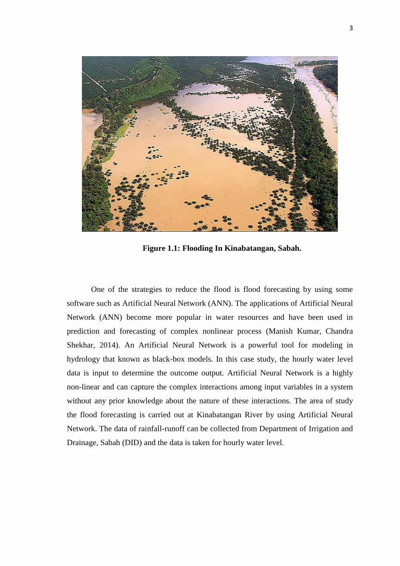
Figure 1.1: Flooding In Kinabatangan, Sabah.
One of the strategies to reduce the flood is flood forecasting by using some
software such as Artificial Neural Network (ANN). The applications of Artificial Neural
Network (ANN) become more popular in water resources and have been used in
prediction and forecasting of complex nonlinear process (Manish Kumar, Chandra
Shekhar, 2014). An Artificial Neural Network is a powerful tool for modeling in
hydrology that known as black-box models. In this case study, the hourly water level
data is input to determine the outcome output. Artificial Neural Network is a highly
non-linear and can capture the complex interactions among input variables in a system
without any prior knowledge about the nature of these interactions. The area of study
the flood forecasting is carried out at Kinabatangan River by using Artificial Neural
Network. The data of rainfall-runoff can be collected from Department of Irrigation and
Drainage, Sabah (DID) and the data is taken for hourly water level.

4
1.2 PROBLEM STATEMENT
The one problems faced by the citizen at Kinabatangan town every year is flood
which is can causes the damaging and destructive of property and infrastructures. Flood
occurs due the increasing of population in this area lead to development of
infrastructure which causes the water movement is changed. Besides, landslide always
occurs because of flood. Flood happens when the amount of the rainfall intensity is
higher than the soil infiltration rate. During this monsoon, not only a lot of resident’s
properties were damaged but they also lack of food and drinks, water, clothes and
others.
Flood warning system is required to enable people take any action to save live
and belonging but due to the lack of flood forecasting equipment and data based on
previous flood level, the authorities failed to give a warning to people ( Hussin,2010).
Furthermore, past study on flood forecasting has been used mathematical model such as
regression model. It proves to give high accuracy model but data is costly to obtain and
can be time to consuming.
Therefore, the Artificial Neural Network is a powerful tool for modeling
especially in forecasting where it solved a complex problem.
1.3 OBJECTIVE
The objectives of this study are:
i) To develop a model for forecasting flood event at Kinabatangan River,
Sabah
ii) To examine whether water level data can be used alone in Artificial
Neural Network modeling.
iii) To achieve a model with high accuracy by utilizing Artificial Neural
network

5
1.4 SCOPE OF STUDY
The area of study is at Kinabatangan River, Sabah and the data will be collect
from the authority of Department of Irrigation and Drainage, Malaysia (DID) which is
the requirement period data such as water level data is from 2004 until 2014. The hourly
data will be based on water level data. The prediction of the flood event is by utilizing
feed-forward Artificial Neural Network (ANNs).
1.5 RESEARCH SIGNIFICANT
The expected outcome of flood forecasting for this research is to minimize the
economic losses and the risk to people. This study also able to increases the awareness
among people about the next flood event by predict the water level and also to help
responsible agencies or authority to design the best model to overcome the flood event
in the future.

6
CHAPTER 2
LITERATURE REVIEW
2.1 INTRODUCTION
Flood is a natural disaster than can be happen at any time in wide variety of
locations which can causing a huge damaged in term of livelihood or property in every
year. Sometimes flood event came with a little or without warning. Flood event also
dangerous where it can be killed people. Flood event give impact on human activities
which can threaten people’s lives, property and environment .Last year 2013, Kuantan,
Pahang has been known as the worst flood where two victims were drowned during the
flood event (Awani, 2013). The history of flood was began since 1920 where the major
floods occurs in the years of 1926, 1963, 1965, 1967, 1969, 1971, 1973, 1979, 1983,
1988, 1993, 1998 and 2005. In fact, flood event also occurs in Johor in the end of the
years 2006 and January 2007 due to heavy precipitation which causing the massive
floods and about RM 1.5 million cost of these flood disasters which known as the
highest cost flood event in Malaysian history on 2006-2007. More than RM200 billions
property was damaged and 61 victims was death in flood event at Kuala Lumpur. The
cost of flood event including the damage in infrastructures, bridges, roads, agriculture,
residential properties and private commercial (DID, 2007).

7
2.2 WATER CYCLE
2.2.1 Precipitation
Precipitation or rainfall is a liquid that formed from the rain. Rainfall is a main
role in hydrological phenomena where it is important as primary sources to the human
beings, animals, plants and earth.
2.2.2 Runoff
Runoff is one part of the rainfall or irrigation water and it is occur when there
have a rainfall. Without rainfall, there will no runoff. This is because runoff will occur if
the amount of water failing or precipitation to the ground is higher than the infiltration
rate of surfaces.
2.2.3 Process Of Water Cycle
Figure 2.0: Water Cycle
In this water cycle, it is a continuous cycle where the water that evaporates from the
lake rises in the air in the form of water vapor. Then, water vapor is cools down and
condenses to become clouds. The drops become heavy if enough water condense and
will fall to the ground as a rain or snow. The process of precipitation will return to the
lake via runoff to begin the cycle again.

8
2.3 TYPES AND CAUSES OF FLOOD
The type of flooding is different in terms of forms and degree which can be
dangerous to peoples, property, and environment. This due to the different of depth,
velocity, duration and the others hazards that related to floods. There are two majors of
flooding which are coastal floods and inland flooding (Smith et al, 1998).
2.3.1 Coastal Flooding
Coastal flood event happen when the sea level is higher than normal and storm
surges causing the sea water pushed to ashore. As a result, the sea water will overflow
onto the land. Coastal flood is influenced by this combination of work when the tide is
higher; a low pressure area which forms a storm and a wave action depends on wind
speed and direction.
2.3.2 Inland Flooding
Inland flood event is causes by the protracted or intense rainfall. There are
several different types of inland flooding which are overland flow flooding, river
flooding occurs and flooding from artificial drainage system. Overland flow flood
occurs when the intensity of rainfall is higher than the soil’s infiltration rate of the
ground to absorb it. This event will affect to the localized area only. River flooding is
occurs when the catchment area of river receive a greater amount of water than usual
such as rainfall or melting snow. The river cannot cope the exceed water which may
causes the water level higher and floods disaster will occurs.

9
2.4 IMPACTS OF FLOOD
Flood event is a common occurring natural event in Malaysia which is leaves a
massive effect to human, property, infrastructures and environment.
2.4.1 Impacts on Human
Flooding may causes physical injury, illness and death to livelihood. Fast
flowing or rapidly rising flood water can be dangerous to people where it is more risk
when floodwater carrying the debris. It might cause the physical injuries to people that
contact with floodwater. Not only that, floodwater also can hide others hazards for
pedestrians such as the manhole that covered by floodwater. Diseases is the one of the
impact to people during the flood event where floodwater might be contaminated by
sewage or other pollutants which can may affect to their health(OPW, 2009).
2.4.2 Impacts on Property And Infrastructures
Flooding may causes the huge damaged to property and infrastructures such as
transport or utilities which impacts on local and regional economies. Flooding of
primary roads or railways can deny access to large areas beyond those directly affected
by the flooding for the duration of the flood event, as well as causing damage to the
road or railway itself. Flooding of water distribution infrastructure such as pumping
stations or of electricity sub-stations can result loss of water or power supply over large
areas. This can magnify the impact of flooding well beyond the immediate community.
The long-term closure of businesses, for example, can lead to job losses and other
economic impacts (OPW, 2009).
2.4.3 Impacts on Environment
. Significant detrimental environmental effects of flooding can include soil
erosion, bank erosion, land sliding and damage to vegetation as well as the impacts on
water quality, habitats and flora and fauna caused by bacteria and other pollutants
carried by flood water. Flooding can however play a beneficial role in natural habitats.
Many wetland habitats are dependent on annual flooding for their sustainability and can
contribute to the storage of flood waters to reduce flood risk elsewhere (OPW, 2009).

10
2.5 FLOOD FORECASTING IN MALAYSIA
2.5.1 Flood Warning System
The purpose of flood warning system is to facilitate people to saves their lives
and belonging and help agencies to carry out evacuation of population during floods.
The flood warning system was provided since 1925 for flood event the first installed
along Kinta River, Perak, Kelang River, Selangor River and Bernam River in Selangor.
Components of flood warning system is to monitoring of rainfall and river flows
that may lead to flooding. Besides, determine the flood impacts on the community by
interpretation of prediction. The construction and dissemination of warning messages is
to describe what is happening and will happen, the expected impacts and the actions
should be taken during flood event. This message warning will be spread by agencies
involved to all community members. Warning message will be dissemination through
media social such as television, radio or others. After the flood event, the warning
system will be review (DID, 2014).
Besides, the number of telemetry station in Malaysia for rainfall is 140 station,
water level is 39 station and for combined is 274 station. This telemetry station is to
monitoring the rainfall and river flows.
11
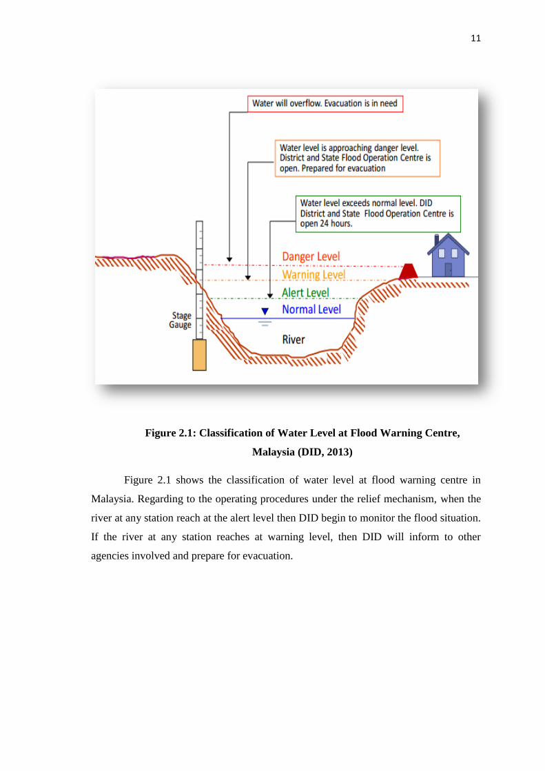
Figure 2.1: Classification of Water Level at Flood Warning Centre,
Malaysia (DID, 2013)
Figure 2.1 shows the classification of water level at flood warning centre in
Malaysia. Regarding to the operating procedures under the relief mechanism, when the
river at any station reach at the alert level then DID begin to monitor the flood situation.
If the river at any station reaches at warning level, then DID will inform to other
agencies involved and prepare for evacuation.

12
2.6 ARTIFICIAL NEURAL NETWORK (ANN)
The history of artificial neural network (ANNs) was begin in 1943 when a
neuroscientist, Warren McCulloch and a logician, Walter Pitts was combined their ideas
to proposed a simple model of neurons which is called McCulloch-Pitts neurons or
MCP neurons for a short name. This neuron is about the computation of the logical
function.
Figure 3.4: McCulloch Pitts Neuron (1943)

13
Donald Hebb (1949) was proposed learning on the plasticity in neural network
which is depends on the plasticity of the circuits in the brain and the ability of the
neurons to changes the efficiency of the synaptic transmission. Hebb’s law is created to
become a learning of the neuron. P. Junsawang et al (2007) proposed a feed forward
ANN as a tool for estimation of runoff in Mae Tun River, Thailand and trained by using
back-propagation algorithm. K. K. Kuok et al (2007) and M. R. Yazdani et al (2009)
used two models of neural network namely Multilayer Perceptron (MLP) and Recurrent
Network (REC) for prediction of rainfall runoff which is the result showed that MLP is
slightly better than REC network. P. Mittal el al (2012) proposed a dual artificial neural
network (D-ANN) which is to improve the model performance and carried out for
hourly river flow data of Kolar Basin, India. It is also used the feed forward artificial
neural network (FF-ANN) which are in-terms of statistical indices such as coefficient of
correlation, coefficient of efficiency, root mean square and compared it with D-ANN
model. The result indicated that D-ANN is better than FF-ANN

14
CHAPTER 3
METHODOLOGY
3.1 STUDY AREA AND DATA COLLECTION
The Kinabatangan River is the largest and longest in Sabah, Malaysia.
Kinabatangan River is a large proportion water supplier to Sandakan, Sabah’s second
largest urban center to people living in village within Kinabatangan River such as Balat,
Barek Manis, Bukit Garam and Tangkulap. The total of population is about 86,783
people live in Kinabatangan Town. Kinabatangan River with 560 km is the major river
which is located at 117’ 35’ 50 longitude and 5’ 18’ 35 latitude with the catchment area
16,800 km2 is a part of the Kinabatangan basin, Sabah. The elevation of study area is 23
meters and its covers almost 23 percent of the total land area of Sabah. Mean annual
rainfall in the basin about 2,300 mm to 3,000 mm per year. Figure 3.1 shown the
location of Kinabatangan River and its river cross section station.
The purpose of choosing Kinabatangan River as the study area is because
flooding occurred since year 1963, 1967, 1986 and 1996 along the rivers which causing
serious damaged to livelihoods and property. It is also the largest remaining floodplain.
Flood Forecasting is carried out to minimize the flood event. Therefore, water level data
is used for flood forecasting which is selected from Belat station and water level data
were obtained from Department of Drainage and Irrigation (DID) Sabah from year 2004
until 2014. As we can see in the Figure 3.2, the water level at Belat Station is near to
Alert Level where the authorities from DID is start to monitor flood situation.

15
Figure 3.1: Kinabatangan River, Sabah (DID)
Figure 3.2: Water Level Elevation status at Kinabatangan River section

16
3.2 ARTIFICIAL NEURAL NETWORK (ANN)
In recent years there has been a confluence of ideas and methodologies from
several different disciplinary areas to give rise to an extremely interesting research
called Artificial Neural Network (ANNs). Artificial Neural Network is an extremely
simplified model of the brain. The process of this network is related to brain function of
biological inspiration where it consists of a large number of highly connected elements
called neuron. In biological, neurons have three major components which are dendrites,
the cell body and the axon. The dendrites are network of nerve fibers that carry
electrical signals into the cell body. The axon is a single long fiber that carry the signal
out from the body cell to the others neurons while the cell body is the important cell
where is to sums and thresholds incoming signals in and out. The connection between
an axon and dendrites is called as synapses. Figure is a simplified schematic diagram of
biological neuron.
Figure 3.3: Neuron Scheme
Recommended