
Feering
Brook
Court
2 a3
4
Depot
Little London
Business Park
River
Blackw
ater
Twirl Hole
Gore Pit
Threshelfords
Bridge
Hanover Square
Church
Track
Church Farm
Terrace
Drummonds Centre
Church View
Farm
Drain
HouseRiverview
END
Orchard
Cemetery
CP & ED
Bdy
CLOSE
Primary SchoolChurch of England
Def
Birchfield
Issues
Weir
Pp
LB
SL
FB
Works
TCB
SS
ESS
Foot
Gd
23.2m
26.6m
29.4m
29.8m
22.3m
29.9m
30.8m
30.2m
24.4m
24.3m
28.0m
31.4m
24.1m
31.7m
31.9m
35.4m
35.7m
26.3m
22.0m
22.1m
CR
GP
COCR
School
Ward Bdy
Pond
Wood Cottage
MP 42.75
MP 43.25
MP 42.5
MP 43
Pump
El
Sub
1.52m RH
Sluice
Estate
Spring
Lych Gate
Pol Sta
Tk
Garage
Cricket Ground
Kelvedon St Mary's
Playing Field
Sub Sta
Sinks
Hazelhu
rst
Meadow
Oval House
ROAD (FEERING)
Sta
WAY
Pavilion
SPA
Und
Path (um)
WATE
RMILL
Tree
DRIFFIELD
AVOCET CL
STATION ROAD
Pisces
Spice Tree
Apple Tree
PACKE CLOSE
RAVEN
SWAN
GREENWAYS
B 1023
B 1024
Woodheys
Ridge
Copper
Wayside
Rosend
Freshfields
BARNFIELD
BITTERN
October
SHER
WOOD
Tweed
ale
Feering Lodge
Russets
Yeomans
Foliot
s
Brookside
Byfield
Tavern
Cops View
FEERING HILL
MALLARD CLOSE
INWORTH ROAD
Cowes
Soccavo
Easterford
Spind
les
HARVEST COURT
MARSHALL CLOSE
THE STREET
GLEBE GARDENS
Trevon
e
Beams
PaddockDomus
(cours
e of)
TERN CLOSE
Jubilee
Gdns
Police Houses
Moors Close
Cottages
Ryedene
Cedars
Thimbles
Lee House
Litres
Bows
ORCHARD ROAD
Crofton
RYE MILL LANE
Apple
down
KINGS GARDENS
HolmfieldBirches
Walberswick
HIGH STREET
Speedwell Cottage
Redmays
Amber
ley
Trebah
Ryemead
The
Premier
Cherry Tree
Cottage
Osbourne
Warren
Feering Place
Rye
Brewsters
The Brambles
The Old
End
Gore House
Kelvene
Vicarage
Bushmoor
Cott
The Cottage
Ardleigh
Eden House
LONDON ROADLorien
Lenda
Crimond
Greenacre
HERON ROADAshbourne
Beverley
Rivers House
The Wheelwrights
The Hollies
Carousel
Little Patches
The Coach House
HUNT CLOSE
Sans Souci
Findon
Poyning
sFaira
cres
Rhydfeli
n
Berkshire
Windrush
The Retreat
Coralie
Rothesay
Kilbrogan
Hillfield
Kilnsey
Mots
Gate
Bidlake
Inntel House
Moor
ChandlersPoint
Crow
Sunnyside
Harvest Cottage
Rylands
Follyfaunts
Northwood
Barchris
Barrows
Maytree Cottage
Greenbank
Rydal
The Bungalow
Connemara
Chale
Mill Cottage
Aubrietia
Blackwater House
Willow Bank
Alcina
The Barn
Hanover House
Inn
Quillet
ShellbankHarkstead
Lindan
Burwell
Greenhayn
Nevella
Maroondah
Sun Inn
Rye Mill
Hunters
Ukay House
Hanover
Marneys
Kiltinane
New
Franklin Gate
(PH)
Barn
Oran
a
Cyriana
Mill
GP
Drain
House
Gore Pit
Issues
Drain
30.2m
CR
Bridge
Feering
FB
Rye
(PH)
Path (um)
Barn
CR
2
Track
GP
Track
Und
Church of England
El
Spring
FB
Gree
nacre
Issues
Drain
Ward Bdy
Ward BdyHouse
Bridge
Und
Path (um)
Pump
(PH)
Issues
HERO
N RO
AD
Sta
Sluice
SS
Drain
SL
Sta
Weir
El
Path (um)
Sta
Issues
SL
Track
Path (um)
Drain
Ward Bdy
Cottage
CR
Mill
House
Drain
SL
Church Farm
River Blackwater
El
House
Ward Bdy
Pond
Track
Drain
Pond
Drain
Drain
Issues
Cottage
KEL6CD
FEE4H
"Reproduced from the Ordnance Survey mapping with the permission of the Controller of her Majesty's Stationery Office © Crown Copyright. Unauthorised reproduction infringes Crown Copyright and may lead to prosecutions or civil proceedings." Braintree District Council O/S Licence No. LA 100018490. 2013
Feering - Pre Submission Plan
0 50 100 150Metres
Inset 24
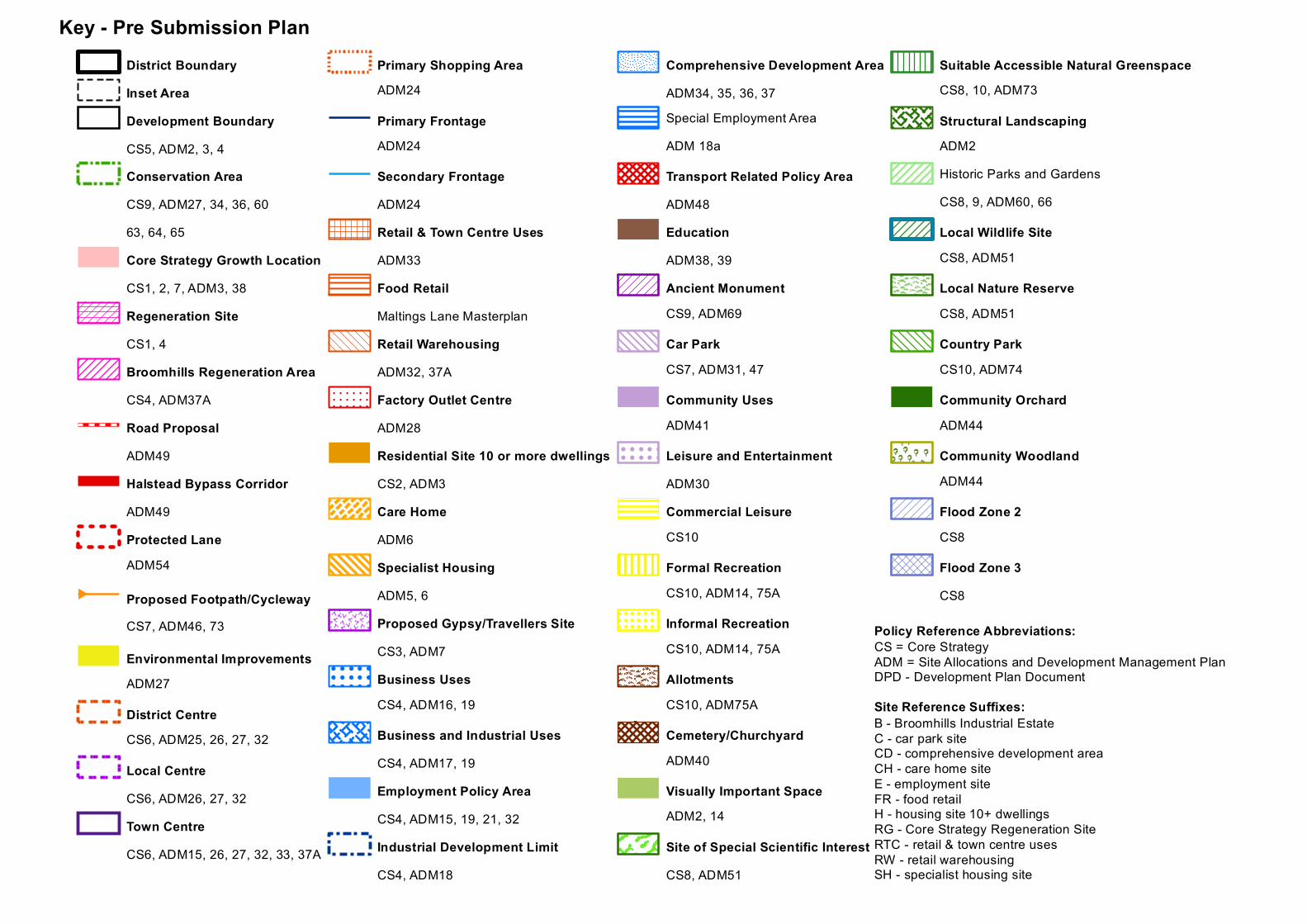
District BoundaryInset AreaDevelopment BoundaryCS5, ADM2, 3, 4Conservation AreaCS9, ADM27, 34, 36, 6063, 64, 65Core Strategy Growth LocationCS1, 2, 7, ADM3, 38Regeneration SiteCS1, 4Broomhills Regeneration AreaCS4, ADM37ARoad ProposalADM49Halstead Bypass CorridorADM49Protected LaneADM54
B Proposed Footpath/CyclewayCS7, ADM46, 73
Environmental ImprovementsADM27
District CentreCS6, ADM25, 26, 27, 32
Local CentreCS6, ADM26, 27, 32Town CentreCS6, ADM15, 26, 27, 32, 33, 37A
Primary Shopping AreaADM24
Primary FrontageADM24
Secondary FrontageADM24Retail & Town Centre UsesADM33Food RetailMaltings Lane MasterplanRetail WarehousingADM32, 37AFactory Outlet CentreADM28Residential Site 10 or more dwellingsCS2, ADM3Care HomeADM6Specialist HousingADM5, 6Proposed Gypsy/Travellers SiteCS3, ADM7
! ! ! ! ! !
! ! ! ! ! !
! ! ! ! ! !
! ! ! ! ! !
Business UsesCS4, ADM16, 19
Business and Industrial UsesCS4, ADM17, 19Employment Policy AreaCS4, ADM15, 19, 21, 32Industrial Development LimitCS4, ADM18
Comprehensive Development AreaADM34, 35, 36, 37Special Employment AreaADM 18a
Transport Related Policy AreaADM48EducationADM38, 39Ancient MonumentCS9, ADM69
Car ParkCS7, ADM31, 47
Community UsesADM41
! ! ! ! ! !
! ! ! ! ! !
! ! ! ! ! !
! ! ! ! ! !
Leisure and EntertainmentADM30Commercial LeisureCS10
Formal RecreationCS10, ADM14, 75A
! ! ! ! ! ! ! !
! ! ! ! ! ! ! !
! ! ! ! ! ! ! !
! ! ! ! ! ! ! !
Informal RecreationCS10, ADM14, 75A
AllotmentsCS10, ADM75A
Cemetery/ChurchyardADM40
Visually Important SpaceADM2, 14
Site of Special Scientific InterestCS8, ADM51
Suitable Accessible Natural GreenspaceCS8, 10, ADM73
Structural LandscapingADM2Historic Parks and GardensCS8, 9, ADM60, 66
Local Wildlife SiteCS8, ADM51
Local Nature ReserveCS8, ADM51
Country ParkCS10, ADM74
Community OrchardADM44
Community WoodlandADM44
Flood Zone 2CS8
Flood Zone 3CS8
Key - Pre Submission Plan
CS = Core StrategyADM = Site Allocations and Development Management PlanDPD - Development Plan Document
Policy Reference Abbreviations:
B - Broomhills Industrial EstateC - car park siteCD - comprehensive development areaCH - care home siteE - employment siteFR - food retailH - housing site 10+ dwellingsRG - Core Strategy Regeneration SiteRTC - retail & town centre usesRW - retail warehousingSH - specialist housing site
Site Reference Suffixes:
Recommended


