eKadaster: Contributing to
the Malaysian economic
growth
Director General’s Forum;
XXV FIG Congress
Malaysia at a glance Cadastral System in Malaysia Expediting Land Development
eKadaster – JUPEM’s Cadastral Reform eKadaster – boosting the economy
Conclusion
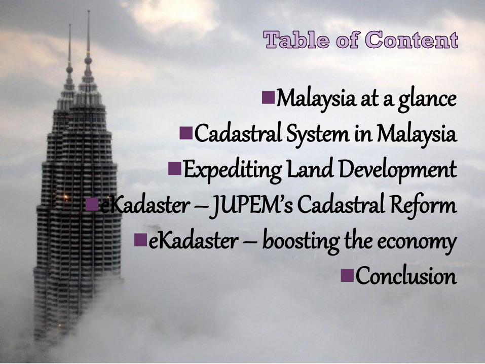
Johor
Kedah
Kelantan
Melaka
Negeri Sembilan
Pahang
Perak
Perlis
Pulau Pinang
Sabah
Sarawak
Selangor
Terengganu
WP Kuala Lumpur WP Labuan
WP Putrajaya
Pie Chart: State Area (in % km2)

Area: 330,803 sqkm
Multi-ethnic country
Federal Territories: Kuala
Lumpur, Putrajaya &
Labuan
Parliamentary Democracy & Constitutional
Monarchy

• Land Alienation
• Registration of titles
• Acquisition of land
• Issuance of mining permits
• Gazette of reservation
• Land dealings
Land matters are State matters
• Land registration & Cadastral Survey
• Indefeasible title
• Fix Boundaries
Torrens System of Land Administration

• Federal Land Commissioner Act (1957)
• Land Acquisition Act 1960
• Mining Enactment 1962
• National Land Code (NLC) 1965
• Established uniform land administration system
• Sabah Land Ordinance (State of Sabah)
• Sarawak Land Code (State of Sarawak)
• Strata Title Act 1985
• Strata Management Act 2013
Primary Statutes

• Real estate manager for the Federal Government
• Provides expertise and consultation in land administration
• Coordinator between State and Federal Government
Department of Director General of Land & Mines Malaysia (JKPTG)
• Federal Cadastral and Mapping agency in Malaysia
• Cadastral Survey administrator
Department of Survey and Mapping Malaysia (JUPEM)

• Administered through State Land Offices
• Coordinated by the Department of Land & Mines
• Cadastral Survey under the purview of Director General of Survey & Mapping Malaysia including Licensed Land Surveyors
Peninsular Malaysia;
• Jurisdiction of Sabah & Sarawak Land & Survey Departments
Sabah & Sarawak
• Land Titles (Qualified and Final Titles)
• Strata Titles
• Mining Lease
• Temporary Occupation License (TOL)
Types of Titles

Qualified Titles
• Introduced in 1965
• To cater Cadastral Survey rising demands
• Issuance of title in advance of final survey
• Supports vibrant land market
• Instigating more land ownership units (QT) than surveyed land parcels (FT)
Pre Comp Plans
• Under NLC, Pre Comp Plans is prepared to show the intended new boundaries and areas of those lots which are based on computation from existing survey data and other relevant data
• Enable land development planning and easily identify land dealings encroachment
Digital environments
• Replacing conventional processing method phase by phase as early as 1985
• The digital environment concept gradually extended from Field to Finish

National Digital Cadastral Database development
Digitally connected government
Efficient public delivery system
Transparency in Cadastral Survey dealings
Changes to land law and survey regulations
Tapping full potential of GNSS
Adopts coordinate based systems
To cope with increasing Qualified Titles.

1 SEPT 2009
1 DIS 2009
15 DIS 2009
1 DIS 2009
28 DIS 2009
15 DIS 2009
MAC 2010
FEB 2010
JAN 2010
JAN 2010
FEB 2010
JAN 2010
** FT Labuan May 2010

+
How ?
eKadaster boosting
Malaysian economic growth
by: • Expedite the Cadastral Survey delivery system
• Increasing FT registration;
• National Digital Cadastral Database;
• Planning tool for land or property
development
• Accurate base maps for asset investment
•Ease of registering property
•Ease of doing business in Malaysia
•Competitiveness in economy performance
•Boost property demand and value

eKadaster
Expedite the Cadastral
Survey delivery system
Innovation in Cadastral
Survey dealings
Increased Issuance of Final Titles
Improved and support the ease
of doing land business and dealings i.e
property registry
Survey Accurate
Coordinate
Seamless and homogenous
Cadastral Survey
information
Accurate base maps
National Digital
Cadastral Database (NDCDB)
Base maps for GIS system
Survey Accurate Spatial
Analysis
Proper enforcement
Better management
Facilitates High Impact
Projects
Mass Rapid Train (MRT)
Assist train alignment
Double Track Railway
Facilitate the design, actual
work and as built work
2nd bridge Penang
Accurate spatial
planning
Iskandar development
Region
New land developments
and township planning
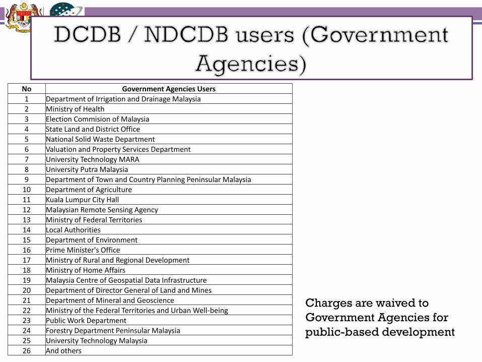
No Government Agencies Users
1 Department of Irrigation and Drainage Malaysia
2 Ministry of Health
3 Election Commision of Malaysia
4 State Land and District Office 5 National Solid Waste Department
6 Valuation and Property Services Department
7 University Technology MARA
8 University Putra Malaysia
9 Department of Town and Country Planning Peninsular Malaysia 10 Department of Agriculture
11 Kuala Lumpur City Hall
12 Malaysian Remote Sensing Agency
13 Ministry of Federal Territories
14 Local Authorities 15 Department of Environment
16 Prime Minister's Office
17 Ministry of Rural and Regional Development
18 Ministry of Home Affairs 19 Malaysia Centre of Geospatial Data Infrastructure
20 Department of Director General of Land and Mines
21 Department of Mineral and Geoscience
22 Ministry of the Federal Territories and Urban Well-being
23 Public Work Department 24 Forestry Department Peninsular Malaysia
25 University Technology Malaysia
26 And others
Charges are waived to
Government Agencies for
public-based development

Source: Tan Sri Yong Poh Kon
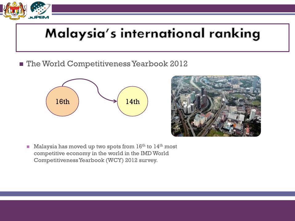
The World Competitiveness Yearbook 2012
Malaysia has moved up two spots from 16th to 14th most
competitive economy in the world in the IMD World
Competitiveness Yearbook (WCY) 2012 survey.
16th 14th


+
Conclusion
eKadaster has definitely
played its role in
boosting the economy
of Malaysia

Department of Survey & Mapping
Malaysia
http://www.jupem.gov.my
Recommended