E600 Series IIPortable, Tactical Weather Radar System


Used as a tactical unit by the U.S. Military, the E600 Series II is the most portable
weather radar system on the market today. This compact unit has been designed to be easy
to transport and can be quickly assembled and field operational in just 30 minutes.
Real Time Weather Radar Surveillance... anywhere in the world.The E600 is the ideal choice for a wide variety of military and civilian applications. Weather sensitive operations rely on the E600 to deliver accurate, real-time informa-tion including: • Location of precipitation • Intensity of precipitation • Direction of cell movement • Speed of cell movement
The E600 has been designed for maximum portability but also has been engineered to withstand the rigors of front line duty. In fact, the E600 is in service in some of the most difficult military theaters around the world today.
The E600’s exclusive combination of power and portability make this system the num-ber one choice in tactical weather radar systems.
The E600 deployed on a pneumatic 50’ mast.
E600 Tactical Weather Radar System

Compact, Lightweight DesignThe E600 radome is constructed of strong but lightweight fiberglass with an a unique UV inhibiting outer layer. The entire radome and antenna assembly weighs in at just 50 lbs. The power supply/control unit is 12”x 11”x 6” in size and fits easily on a table top. Metal parts and fasteners are made of stainless steel, lightweight anod-ized aluminum or stainless steel for added durability. Cables and wiring harnesses are fitted with quick release mil-spec aluminum connectors. Custom made E600 carrying cases are waterproof and are molded of virtually indestructible plastic. Cases are foam lined and include extra lift handles and wheels for easy movement in shipping and in the field. It all adds up to the only true portable weather radar system avail-able today.
115/220v Power Source
USB Interface
Main Cable and Extension if Required
Typical E600 System Field Installation
Radome/Antenna Installed on
Transportable Mastor Fixed Tower
Distribute Images Via FTPto Remote Locations

Radar Control and Display Software
User Friendly OperationThe E600 system includes a laptop com-puter running the familiar Windows XP Professional operating system and EWR’s proprietary WeatherScoutTM software as standard features. All radar functions are controlled via the easy to use and Intui-tively designed control panels that enable the user to select ranges (10,20,40,80,160, and 240 nautical miles), tilt levels in .25° increments (0-15°) and to observe vertical cross sections of storm cells (RHI). Weath-erScout’s unique, GPS based mapping fea-ture creates map sets on the fly, anywhere in the world. Record and playback options allow the operator to record weather events even when the system is unat-tended. These sessions can be recorded and played back or looped at a later time, or transferred via ftp to a remote location. These features and many more make the E600 the most powerful, cost effective and versatile radar solution on the market today.
Complete record, playback and looping features
Dynamic range and height indication simply by pointing the mouse at the storm cell
RHI vertical scan feature allows the user to examine cell height at the click of the mouse
EWR exclusive map generation feature allows the user to create background map sets by
GPS location
Automode allows the user to configure unit to scan and record data while unattended
Saved images can be transferred vai FTP to remote locations
Easy to use Windows interface
E600 Standard Features
• X band R/T operating at 9375 +/- 25 MHz • 18” flat plate antenna system with 360° rotation and 0-15° tilt capabilities • High strength radome assembly with fiberglass lining and UV resistant finish, integrated wiring harnesses, Ventilation system, stainless hardware and beacon. • Pentium IV (min.) laptop computer - 32 bit high resolution display and Windows XP Professional operating system. • EWR Weather ScoutTM software - Complete radar control and display features including range display (10,20,40,80,160, and 240 nautical miles), tilt (0-15°), Vertical scanning capability for cell height study (RHI) Proprietary “one click” GPS location based map creation. • Desktop Control and power supply unit - includes system power supplies and USB to laptop interface. • 125’ main cable and two 100’ extension cables
Optional Components and Features
• Lightning dispersion system • Lightning detection sensor system • GPS handheld sensor • Wind speed and direction • Pneumatic or mechanical type 50’ mast system • Custom, heavy duty transport cases • 30” flat plate antenna (contact EWR for complete information)
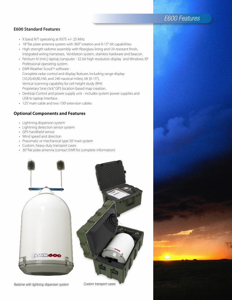
Radome with lightning dispersion system Custom transport cases
E600 Features

E600 SPECIFICATIONS
Applications Portable,FieldInstallationsorFixedBaseInstallation
Mounting OptionalPneumaticorMechanicalMasts,VehicleorRooftopMountingSystems
contactEWRformoreinformation
Range CapableUpto240NM(444km)
Antenna PhasedArrayFlatPlate,LightweightAluminum
Size 18”Diameter
BeamWidth 5.5Degrees
Gain 31dB
SideLobes(max) -25dB
Tilt 0-20Degrees
Azimuth 360DegreeRotationat12rpm
Radome 22”Diameter,38”Height
Construction .125+/-.0625Fiberglass,WhiteUVResistantABSShell
SafetyBeacon Included
GroundingProtection Included
LightningDispersionSystem Optional
Receiver/Transmitter XBand:9375+/-25MHz
EffectiveRadiatedPower 2.5kWto4.0kW3.3KwNominal
EffectiveReceiverSensitivity -110dBmtypical
PulseFrequency 106.5Hz+/-5Hz
Workstation PentiumIVLaptop,WindowsXPandEWRWeatherScoutTMSoftware
Control Unit/Power Supply 115V60Hz/230V50HzSwitchable,28VPowerSupply,USBInterface
Cables 125’MainCableand3-100’ExtensionsIncluded
Shipping/StorageCases OptionalHeavyDutyPlasticwithFoamLinersandWheels
specifications subject to change without notice

336 Leffingwell AvenueSaint Louis, Missouri 63122314.821.1022 fax 314.821.5622www.ewradar.com
©2006 EWR Weather Radar
Recommended