Williams County Comprehensive planseptember 2012 Draft
draft

draft

Williams County Comprehensive Plan i
Williams County Comprehensive planseptember 2012 Draft
draft

ii Williams County Comprehensive Plan
Table of Contents
Chapter 1 Welcome to Williams County, ND 1
Vision, Goals and Objectives 3
Williams County Vision Statement 3
Goals and Objectives 3
Key Recommendations 5
The Code of the West 5
How the Plan is Organized 6
Chapter 2 Comprehensive Plan Users’ Guide 7
Chapter 3 Land Use Concepts & Growth Strategies 15
Land Use Concept Goals & Policies 16
Growth Strategy Map 18
Land Use Strategies / Actions 32
Chapter 4 Transportation 35
Transportation Issues 35
Plan Direction for Transportation 42
Transportation Goal and Policy Direction 51
Transportation Strategies and Actions 54
Chapter 5 Infrastructure and Services 57
Services 58
Infrastructure 58
Infrastructure and Services Goals and Policies 60
Infrastructure and Services Strategies and Actions: 62
Chapter 6 Economic Development 65
Strategies for Diversifying and a “Soft” Landing 66
Economic Development Goal and Policy Direction 69
Chapter 7 Implementation Chart & Cpmrehensive Plan Policies 73
draft

Williams County Comprehensive Plan iii
Appendix 1 Community Setting and Profile 89
Appendix 2 Comprehensive Plan Update Public Outreach 95
Appendix 3 Associated and References Documents 101
Appendix 4 Example Intergovernmental Agreement 103
Appendix 5 Glossary of Terms 105
Appendix 6 Maps 109
Maps
Map 3,1 Growth Strategy Map 19
Map 4.1 Existing County Roads 37
Map 4.2 Road Maintenance Priority Map 43
Map 4.3 Williston Area Missing Links Map 45
draft

iv Williams County Comprehensive Plan
draft

Williams County Comprehensive Plan v
Board of County Commissioners
Wayne Aberle Dan Kalil MartinHanson David Montgomery Barry Ramberg
Acknowledgements
Planning and Zoning Commission
Mark Barstad Brent Bogar Tate Cymbaluk DaveHermanson Dan Kalil George Pederson Charelle Schillo KimSteffan
Steering Committee
TheComprehensivePlanSteeringCommitteewasmadeupofthecountyresidentsalongwithrepresentativesofthePlanningandZoningCommissionandBoardofCountyCommissioners.
DwightAuneRandy Baker
Jody Bergstrom-DeanBrian Bolinski GlenBoyeffMitch Cayko
Tate CymbalukMel Falcon
Warren FroelickVickiHollenBobHorabKent Jarcik
Benjamin KruellDallas Lalim
JerryMartinsonHiramReyez
Charelle SchilloKim SemenkoShawnWenko
Staff
JillEdson,PlanningandZoningAdministrator Steve Mullen, Planner / GIS HelenAskim,HumanResources
draft
vi Williams County Comprehensive Plan
draft

Williams County Comprehensive Plan 1
GRENORApop: 401
HANKSpop: 13
ALAMOpop: 124
WILDROSEpop: 235
TIOGApop: 1,667
RAYpop: 776
WHEELOCKpop: 21
EPPINGpop: 140
SPRING BROOKpop: 27
LAKEZA HL
TWINLAKE S
LAKE SAKAKAWEA
LAKE
SAKAKAWEA
ZAHL
APPAM
CORINTHHAMLET
MCGREGOR
WILLISTONpop: 11,280
TRENTON
LEWIS AND CLARKSTATE PARK
TEMPLE
Williams County - North Dakota
11TH ST W
2ND
AV
EW
UN
IVE
RS
ITY
AV
E
26TH S T W
2ND ST W
42ND ST W 42ND ST E
26TH S T E
1ST ST E
5TH ST W
10TH S T W 11TH ST E
22ND ST E
Dak
ota
Pkw
yE
18TH S T W
4TH
AVE
W
BIS ON DR
13T
HA
VE
W
6TH ST E
8TH ST E
4TH ST E
2ND ST E
15T
HA
VE
W
14T
HA
VE
W
6TH
AVE
E
16T
HA
VE
W
2ND
AV
EE
3RD
AV
EE
1ST
AV
EW
19T
HA
VE
W
9TH
AVE
E
4TH
AVE
E
9TH ST W
6TH ST W
32ND ST W
5TH ST E
40TH S T E
MA
INS
T
17T
HA
VE
W
15T
HS
TW
1ST
AV
EE
18TH S T E
BROAD WAY W
28TH S T W
9TH AVENW
4TH ST W
21S
TAV
EW
34TH S T E
7TH ST E
DA
KO
TAP
KW
Y
14TH S T E13T
HS
TW
BROAD WAY E
22ND ST W
38TH S T W
9TH ST E
SAND CREEKDR
CREST ST
9TH
AVE
W
HIL
LC
TE
17TH S T W
12T
HA
VE
W
29TH S T W
20T
HA
VE
W
20TH S T E
24TH S T E
35TH S T E
25TH S T W
6TH
AVE
W
8TH
AVEW
11T
HAV
EW
RO
SE
LN
FRO
NTA
GE
RD
SIOUX
ST
33RD ST W
£¤2
£¤2
DAKOTA
PARKWAY
£¤85
22N
DA
VE
W
37TH ST W
PH
EA
SA
NT
RU
N
14T
HS
TW
RE
CLA
MA
TIO
ND
R
35 TH ST W
FRONT ST
24T
HA
VE
W
17T
HC
TW
5TH
AVE
W16T
HS
TW
36TH ST W
3OTH ST W
KNOLLST
27TH S T W
30TH S T W
DA
VID
SO
ND
R
3RD
AV
EW
8TH ST W
34TH S T W
19TH ST W
10T
HA
VE
W
33RD ST E
7TH ST W
HIGHLAND DR E
WA
SH
ING
TO
NA
VE
25TH S T E
HIGHLAND DR W
10T
HA
VE
E
16TH S T E
16T
HC
TW
PAR
KP
L
6THAve NW
HIL
LC
T
23RD ST W
21S T ST W
24TH S T W
LINDALN
23rd
CT
38TH S T E
18T
HC
TW
23RD TERR E
PARKW
AYDR
LANDES ST
HILLSIDE CT
17T
HC
IRW
SK
YW
AYC
T
24TH S t E
19TH S T E
24T
HC
T
23RD ST E
22ND
AVE W
33RD TERR
25T
HC
T
31TH P L
34TH P L
35TH P L
36TH P L
18
TH
AV
EW
7TH ST W
1ST
AV
EW
25TH ST W
2ND
AV
EE
10T
HAV
EW
6TH
AV
EE
1ST
AV
EW
13T
HA
VE
W
11T
HAV
EW
8TH
AV
EW
FR
ON
TAG
ER
D
36TH ST E
1ST
AV
EE
4TH
AVE
E
8TH
AVE
W
8TH
AVE
E
14TH S T W
3RD
AV
EE
9TH
AVE
E
6TH
AVE
W
MA
INS
T
22ND ST E
13T
HA
VE
W
17T
HC
TW
£¤85
6TH ST W
2ND
AV
EE
4TH ST W
21S
TAV
EW
12TH ST E
16TH ST W
28TH ST W
9TH AV E NW
8TH
AV
EE
DA
VID
SO
ND
R
7TH
AVE
E
5TH
AV
EW
1ST
AV
EW
9TH
AVE
W
3RD
AV
EW
8TH ST W
13TH S T W
18T
HC
TW
6TH
AVE
E
13TH S T W
FRO
NTA
GE
RD
4TH
AVE
W
9TH
AVE
W
6TH
AV
EW
16TH S T W
19TH S T W
1ST
AV
EW
2ND
AV
EW
7TH
AVE
E
4TH
AV
EE
19T
HA
VE
W
15TH ST W
13T
HA
VE
W
29TH S T W
8TH
AVE
W
9TH ST E
7TH
AVE
W
1ST
AV
EW
15TH S T W
6TH
AVE
E
1ST
AV
EE
21S
TAV
EW
6TH ST W
22N
DA
VE
W
1ST
AV
EW
4TH
AVE
E
11T
HA
VE
W
16T
HA
VE
W
25TH S T E
17T
HA
VE
W
11THAVEW
4TH
AVE
W
4TH ST W
35THST W
1ST
AV
EE
2ND
AV
EE
5TH ST E
27TH S T W
20T
HA
VE
W
18TH S T E
2ND S T W
5TH
AV
EW
Sloulin Field International Airport
Williston StateCollege
LITTLE
MUDDYRIVER
£¤40
67TH ST NW
MA
INS
T
SIGNAL ST
105T
HA
VEN
W
2ND
STNW
2ND ST SE
1ST ST NE
6TH ST NE
4TH ST NEBEN
SO
NS
T
5TH ST NW
DAK
OTA
ST
1ST ST SE
4TH ST SE
2ND ST SW
TOR
NIN
GS
T
FRONTAGE RD SW HO
SE
TH
ST
LIND
AS
T
68TH ST NW
FRONT S T W
5TH ST NE
3RD
S TN W
WE
LOS
TMO
NTA
NA
ST
5TH ST SE
BEN
SO
NS
T
WE
LOS
T
MAI
NS
T
114T
HA
VE
NW
7TH AVE W
115T
HA
VE
NW
SCO
RE
ST
WE
ST
ST
1ST AVE E
RAILROAD AVE
WIN
THE
RS
T
LAK
ES
T
1ST AVE W
5TH AVE W
4TH AVE W
3RD AVE W
2ND AVE W
7TH AVE E
6TH AVE E
4TH AVE E
PARK RD
CO
MFO
RD
ST
3RD AVE E
CH
UR
CH
ST
2ND AVE E
5TH AVE E
£¤2
VIE
WS
T
PALM
ST
6TH AVE W
£¤2
TIOGA RAY
WILLISTON
0 4 82 Miles
$0 0.1 0.20.05 Miles0 0.1 0.20.05 Mi les 0 0.2 0.40.1 Miles
Mountrail County
Burke County
McKenzie County
RooseveltCounty
Sheridan County
RichlandCounty
Divide County
MO
NTA
NA
MO
NTA
NA
Intermittent Lake or Pond
Perennial Lake or Pond
Intermittent Marsh or Wetland
Perennial Marsh or Wetland
Intermittent StreamPerennial Stream Paved Road
Railroad
State Highway
State Park
Street
Low Maintenance RoadPrairie Trail
Gravel Road
Williams County GIS Office, Willis ton, North Dakota. 2007
Williams County is 2,077 square miles and is mainly rolling prairie land. it inlcudes 10 incorporated municipalities. The 3 largest cities are Williston, the county seat and population center, Tioga, and Ray. The county also has 57
townships.
Williams County and several adjacent counties are underlain by an oil-rich shale formation known as the Bakken. The County experienced a previous oil boom in the late 1970s whose abrupt demise a few years later left many projects unfinished and placed a financial burden on the communities and individuals that only recently was overcome. With the relatively recent innovation of hydraulic fracturing rejuvenating hard-to-extract formations, since approximately 2005, Williams County is once again at the epicenter of an intense oil and gas boom. This boom is predicted to last another 15 to 25 years, peaking around 2025 then scaling back to maintenance level of operations for another indefinite period of time.
Williams County’s GroWth boom
The oil boom has triggered a steep population growth with projections that more than double the 2010 Census count of 22,398. If the level of projected growth materializes over the next 15 – 25 years, how it develops will have a dramatic impact on the quality of life of its residents, and the fiscal well-being of the local government.
While much of the growth impact is visible in Williston and Tioga, the two largest cities, the unincorporated areas of the county have also been impacted by the current boom in many ways, including:
• Over 10,000 workers are housed in “man camps” located outside of city boundaries, many requiring hauling of water and sewage to the few community treatment plants
Chapter 1WelCome to Williams County, nD
Figure 1-1: Map of Williams County, ND
draft

2 Williams County Comprehensive Plan
• Residential subdivisions scattered in the rural areas of the county, putting many new homes far from emergency services and infrastructure• Increased number of septic systems in areas with a history of non-suitable soils• Over 450 drilling rigs are moved every 30 days to new locations—hauling the extremely heavy rigs breaks gravel roads that the County is barely able to maintain• The dispersed and random pattern of oil and gas drill and well activity that makes it difficult to predict impacts to roads and future employment locations• A growing transient population that is perceived to increase crime and decrease overall community safety and well-being• High levels of truck traffic related to hauling sand, water, oil, and machinery that results in road damage and safety concerns• Increased competition for housing resulting in increases in the price of land, houses and rental units• Increased need for funds to pay for road, infrastructure and service improvements.
A major objective of this Master Plan, as expressed by residents, is to better manage and guide growth to appropriate locations with the capacity to absorb the impacts of that growth in an efficient manner.
At the same time, having experienced a previous boom-bust cycle, the county is also aware that precautions need to be taken in order to avoid the negative impacts of the bust – vacancies, hollow buildings, and public debt – and to harness the boom while it lasts – to maintain roads, enhance communities, retain the rural character and leave a legacy of amenities for future generations.
Williams County, through this comprehensive plan, is charting how best to accommodate future growth of all types in the community: housing, commercial, and industrial development. At the same time, the Plan addresses the infrastructure framework necessary to support that growth: transportation, utilities, and natural resources.
While each land owner has inalienable property rights, if individual decisions are not coordinated, at least at a basic level, they can lead to a variety of negative impacts that affect others’ use of their properties. These impacts may include incompatible uses next to each other, inefficient layouts of roads and utilities (often maintained at public expense), and increased public costs for services (such as fire and police protection and school bus service). Thus, the pattern of development influences quality of life; health, safety, and welfare; and cost to the public, in the present and the future. This coordination also brings predictability about the future and an ability to anticipate problems in a proactive rather than reactive manner.
Figure 1-2: The energy industry is currently booming in the region causing growth impacts to the community
Figure 1-3: Population estimates and projections for the county over the next 25 years
draft

Williams County Comprehensive Plan 3
vision, Goals anD objeCtives
Williams County vision statement
Williams County desires to retain its agricultural heritage and rural character over time despite facing the realities of a boom - bust economy. To do this, new development is encouraged to occur in and adjacent to existing communities and not
scattered throughout the countryside. The County also desires to plan ahead to ensure the harnessing of the benefits of the boom and also soften the impacts of any bust.
Goals anD objeCtives
The goals and objectives, derived out of the public engagement process, for this planning effort include:
Goal: Efficient, orderly growth
Objectives:
• Growth is directed to areas that are most cost efficient to grow • Growth is directed to the most suitable locations with infrastructure and services • Growth is directed to existing towns and developed areas • Adequate emergency response times are considered during development proposal review • Commercial and industrial land is designated in a few defined locations • Incompatible adjacent land uses are avoided
Goal: Well-maintained county highways and roads
Objectives: • Connection of missing segments of roads • Improved road maintenance • Construction of truck route west of Williston • Increased traffic safety and access control
Figure 1-4: Traditionally, Williams County has been primarily an agricultural community
draft

4 Williams County Comprehensive Plan
Goal: Protection of natural resources
Objectives: • Protection of river and creek corridors • Protection of aquifer for clean water • Protection of habitat areas especially riparian areas
Goal: Remedied crime and social issues
Objectives: • Emergency service response time is maintained at its current level of service of 10 – 15 minutes • Law enforcement increases at same rate as development • Increase in the range of housing options • Reduction of the cost of living
Goal: Protection of rural character and agriculture heritage
Objectives: • Retention of a rural character and “small town” feel in the rural areas of the county • Protection of prime agricultural land from development
Goal: Adequate public facilities and services
Objectives:
• Retention of current levels of service and keep pace as the community grows
• Identification of areas where sewer is needed to support development
• Retention and expansion of good schools and other education opportunities
• Traffic safety improvements
• Development of recreation opportunities
• Lessen government expenditures
Figure 1-5: Main Street in Epping
draft

Williams County Comprehensive Plan 5
Key reCommenDations
Among the many recommended actions, there are several that are most important to achieving the vision and goals of the Comprehensive Plan. They are:
• Adjust the County land development regulations to be consistent with the Comprehensive Plan.
• Coordinate the County’s capital improvements program (CIP) with the Comprehensive Plan.
• Coordinate with communities to plan Growth Areas and direct future development there to efficiently use the existing infrastructure and facilities.
• Plan ahead to coordinate the layout of major roads and related land uses to avoid duplication and conflicting decisions between the County and municipalities.
the CoDe of the West
It is important to understand that life in the country is different than life in the city, therefore, those interested in purchasing land should be informed of the differences prior to making the decision. The Code of the West is an unwritten code of conduct that has been a guide for country living since the westward expansion of the United States first occurred. Key tenets oif the Code of the West include:
• Agriculture is valued by the community. Do not expect the County government to intervene with agricultural operations or when they occur. Many occur around the clock and can cause dust, smoke, odors, and noise. Sometimes chemicals (such as fertilizers, insecticides, and herbicides) may be used.
• Emergency service vehicles may not achieve adequate access to your property and response time will depend on your proximity to a emergency service station.
• Expect that extreme weather conditions can destroy roads. Roads can also become impassible due to extreme weather.
• Utility services may be limited in some rural areas. Other services such as school bussing programs, mail delivery, and newspaper delivery may also be limited in many areas.
• Dust happens and needs to be expected.
• If the road is unpaved now, it is highly unlikely that the road will be paved in the future.
• Many people do not own the mineral rights under
their property.
Figure 1-6: The railroad has connected communities within the county for decades
draft

6 Williams County Comprehensive Plan
hoW the plan is orGanizeD
Chapter 1 Introduction to Williams County – provides a background description of Williams County and the issues to address in the Williams Comprehensive Plan.
Chapter 2 Introduction to a Comprehensive Plan – explains what a comprehensive plan is and the county’s authority to prepare a plan
Chapter 3 Land Use Concepts and Growth Strategies – presents major directions and concepts of the plan to guide future growth.
Chapter 4 Transportation – contains the specific issues, goals, policies for transportation systems throughout the county.
Chapter 5 Infrastructure and Services - contains the specific issues, goals, policies for transportation systems throughout the county.
Chapter 6 Economics and Economic Development - contains the specific issues, goals, policies for county finances and economic development throughout the county.
Chapter 7 Implementation Chart - contains the actions to implement the plan over time.
Appendix 1 – Comprehensive Plan Public Engagement – outlines the public engagement process employed during the preparation of the comprehensive plan.
Appendix 2 – County Profile – provides a snapshot of the existing conditions in the county.
Appendix 3 – Physical Characteristics of the County – describes the climate, soils and geology, agricultural resources, water resources, and mineral resources of the county.
Appendix 4 – Associated and Referenced Reports and Documents – lists relevant reports and documents associated with the Williams County Comprehensive Plan.
Appendix 5 – Glossary of Terms – defines terms used within the comprehensive plan.
Appendix 6 – Example Intergovernmental Agreement
Appendix 7 - Additional Maps
draft

Williams County Comprehensive Plan 7
Chapter 2Comprehensive plan users’ GuiDe
A comprehensive plan is designed to provide guidance to decisions affecting the future shape and character of the county through land use and development considerations. The plan develops a shared vision of what the county
will look like in 20-25 years and then creates goals and policies to help achieve that vision. It is advisory rather than regulatory in nature, but it is the foundation for land management documents such as zoning and subdivision regulations and is used as a strategic tool to help a county guide development and investment decisions to achieve a healthy and balanced community.
The purpose of the comprehensive plan is to preserve and improve the quality of life enjoyed by the residents of Williams County. The accelerated growth in Williams County over the last few years, due to the energy industry, has begun to change the quality of life experienced by county residents. The plan is to guide the development of non-urban areas to appropriate locations; to provide opportunity and safety to county residents; to lessen government expenditures; and to conserve and develop natural resources.
The Williams County Comprehensive Plan (the “Plan”) has been developed to provide a foundation for decisions and policies that will guide the future land use and development in the unincorporated portions of the county. It is designed to serve as a tool for citizens, county staff and elected officials, and focuses on responding to both the immediate and anticipated long-term needs of the county. The Williams County Comprehensive Plan represents the official statement regarding the manner in which development is to occur to achieve its physical, economic, social and environmental goals.
This plan builds on the 1986 comprehensive plan as well as the adopted comprehensive plans of the City of Williston and City of Tioga.
Authority for the Comprehensive Plan
Titles 11, 40, and 58 of the North Dakota Century Code provide the basis for county land use planning and regulation. This enabling legislation allows local jurisdictions the authority to mandate certain aspects of planning.
The Williams County Code gives a strong role to the comprehensive plan with regard to land use decision- Figure 2-1: The comprehensive plan provides the basis
for and is used with other county plans, codes and standards
draft

8 Williams County Comprehensive Plan
making: “With the exception of agricultural uses, buildings or structures, no buildings, structures or land shall hereafter be used or occupied unless in conformity with the Comprehensive Plan of Williams County, North Dakota (or the provisions of Williams County Townships and municipalities which are more restrictive).”
Comprehensive Plan Components
Vision Statement
The vision statement is a broad description of the desired future condition achieved between now and 2035. This vision describes Williams County’s assets and values and focuses on moving the community toward achieving the preferred future growth scenario.
While the vision statement is the backbone of the comprehensive plan, it is realized through a well thought out set of goals, policies, and strategies and actions that provide a clear blueprint for where the county would like to go and how it will get there.
Goals
Comprehensive plan goals provide concise statements of what the community aims to accomplish within the next 20 years. The goals add specificity and more detail to the vision. Goals are instrumental in evaluating future land use decisions and then further implemented by the policies, and strategies and actions that follow.
Policies
Policies are defined as: a course of action, guiding principle, or procedure to guide present and future decisions. Policies are established, and then implemented through actions, including legislation, budget decisions, etc. Comprehensive plan policies are important to provide ongoing guidance for elected and appointed community leaders, developers, the public, and the county staff and administrators to enable consistent decisions over time about development, budgeting, priorities, and investments in the county.
Strategies and Actions
Strategies and actions provide suggested specific actions and programs that can be taken to implement the Plan. Because priorities and budgets will change from year to year, county staff and officials should consider the potential actions and draw up an implementation plan, or specific tasks and assignments to be accomplished each year, and modified on an as-needed basis.
draft

Williams County Comprehensive Plan 9
Maps
Maps - which display such information as future land use and prioritized road improvements - are to be used as tools for development review.
How to Use the Plan
The Comprehensive Plan is to be used by the Planning and Zoning Commission, Board of County Commissioners, County staff, developers, and residents.
For County staff, the plan will be used to analyze development proposals, zoning changes, and subdivision requests. It will be used as a guide for making changes to land management strategies and for the initiation of new plans or projects. It is also used to plan for capital improvements and can be a basis for grant applications.
The Planning and Zoning Commission and Board of County Commissioners will refer to the plan when making land use decisions. Following the Comprehensive Plan will help ensure that decisions are defensible. Knowing that County officials follow the plan provides developers and citizens with a predictable process and reliable guide for their own decisions regarding change for their properties or those adjacent to their properties.
Directions in the form of written goals, objectives, and implementation actions are supplemented by the Comprehensive Plan maps. When referring to the Comprehensive Plan, users should consider the written directions as well as the maps.
Maintaining Consistency between the Comprehensive Plan, Land Use Regulations and Development Decisions
For the Plan to remain relevant over time, the County Planning Commission must be able to review, revise, and update the Plan on an as needed basis to respond to significant trends or changes in the economic, physical, or social conditions of the community.
In Williams County, the comprehensive plan establishes the broad land uses and the Zoning Ordinance and Subdivision Regulations of Williams County, North Dakota establishes the detailed standards such as specific uses, minimum lot size, and setbacks. The Zoning Ordinance and Subdivision Regulations of Williams County, North Dakota requires that land use decisions be consistent with the comprehensive plan. However, the North Dakota Century Code requires that zoning decisions are consistent with the county comprehensive plan.
Amending the Comprehensive Plan
Revisions to the comprehensive plan will be conducted according to three distinct and different procedures: (1) comprehensive updates (2) major amendments and 3) minor amendments.
draft
10 Williams County Comprehensive Plan
Comprehensive Updates
The purpose of a comprehensive update is to reevaluate the foundations, and directions of the Plan, and to set new directions if necessary, to make sure that the Comprehensive Plan continues to be an effective guide for growth and change in Williams County.
It is intended that a review of the comprehensive plan be conducted every 5 years (unless otherwise directed by the Planning Commission) to determine whether a comprehensive update is warranted. In making a determination of when a comprehensive plan update should be initiated, a prime consideration should be the magnitude of the changes that have occurred since the Plan was last updated. For instance, significant changes in the economy, the environment, housing affordability, traffic congestion, or projected growth may require a plan update or an update to a specific plan element.
If a comprehensive plan update is initiated, the county will thoroughly reevaluate the goals, policies, and strategies of the Plan, as well as the Growth Strategy Map. A comprehensive plan update will also include a thorough review of the validity of all background information contained within this Plan and should include broad opportunities for involvement by the public, elected and appointed officials, county staff, and other affected interests. Once the update is complete, the Planning Commission shall then amend the comprehensive plan based on North Dakota State Statutes, the consideration of the public input, recommendations of staff and specialists, and evidence provided at public hearings.
• Major Amendments
Amendments to this Plan, that occur outside of a regular comprehensive plan update, are considered to be major if they constitute a significant change in the vision, goals, policies and/or land uses of the county. Major amendments may include revisions requested by individual property owners, as well as changes to reflect or incorporate adoption of other plans (e.g. municipal changes within growth areas, departmental master plans, etc.), or a recommendation from the staff, Planning Commission or the Board of County Commissioners.
The Planning Commission shall determine whether a proposed amendment is major or minor after reviewing a recommendation from county staff. Major amendments may be processed at any time, pursuant to the standards or approval, submittal requirement, and procedural requirements below.
Standards for Approval
A major plan amendment shall be approved if the Planning Commission makes specific findings that:
1. The existing comprehensive plan and/or any related element thereof is in need of the proposed amendment; and
2. The proposed amendment is compatible with the surrounding area, and the goals and policies of the Plan; and
3. The proposed amendment will have no major negative impacts on transportation, services, and facilities; and
4. The proposed amendment will have minimal effect on service provision, including adequacy or availability of facilities and services, and is compatible with existing and planned service provision; and
draft

Williams County Comprehensive Plan 11
5. The proposed amendment is consistent with the logical expansion of services; and
6. The county or the general area in which an amendment is proposed has changed or is changing to such a degree that the amendment is in the public interest; and
7. Strict adherence to the Plan would result in a situation neither intended nor in keeping with other key elements and policies of the Plan; and
8. The proposed plan amendment has a significant public benefit; will promote the public welfare and will be consistent with the goals and policies of the Williams County Comprehensive Plan and the elements thereof.
Procedural Requirements
To process a major amendment, the following steps should be followed:
1. Pre-Application Conference. The applicant shall schedule a pre-application conference.
2. Submit Application. The application materials as listed in the submittal requirement and any additional materials as determined in the pre-application conference.
3. Determination of Completeness. The Zoning Administrator will review the application for determination of completeness.
4. Schedule Public Hearing. Upon a determination of completeness, the Zoning Administrator will schedule the application for consideration by the Planning Commission on the agenda following the scheduling of previously submitted and complete applications. Public notice of the hearing shall be made pursuant to the County Procedures.
5. Evaluation by Staff Review. Upon determination of completeness, the Zoning Administrator will review the application for compliance with the applicable standards set forth above. A staff report shall be prepared. The evaluation of the application may include comment by referral agencies.
6. Review by the Planning Commission. A major amendment application will be considered by the Planning Commission at a public hearing, after proper notice. The Planning Commission will approve or deny, by written resolution, the application based upon compliance with the standards as outlined above. If the amendment is approved by the Planning Commission, the Planning Commission shall certify the amended Comprehensive Plan to the Board of County Commissioners and municipality within Williams County.
7. Objection. Any municipality within Williams County has the right to file a written objection to the amendment within 30 calendar days following adoption of the amendment.
draft

12 Williams County Comprehensive Plan
• Minor Amendments
A minor amendment is an amendment that does not represent a change to the vision, goals, and policies of the Williams County Comprehensive Plan and has modest, if any, impact on adjacent land uses, infrastructure and services. A minor amendment may include small projects that are consistent with the surrounding area, or may be as small as correcting text or map errors.
Minor amendments may be processed at any time, pursuant to the standards or approval, submittal requirement, and procedural requirements below.
Standards for Approval
A minor plan amendment shall be approved if the Planning Commission makes specific findings that:
1. As applicable, the proposed text or designation addresses errors in the Growth Strategy Map or Comprehensive Plan text; and
2. The proposed designation will result in a logical and orderly development pattern and will not constitute spot designation; and
3. The proposed designation is in compliance with the goals, policies, and strategies /actions of the comprehensive plan and any applicable intergovernmental agreement affecting land use or development; and
4. The amendment does not create unreasonable hazards or undue hardship upon adjacent property owners and/or residents of Williams County.
Procedural Requirements
Procedural requirements for a minor amendment are as follows:
1. Pre-Application Conference. The applicant shall schedule a pre- application conference.
2. Submit Completed Application Form. In addition to the application form all materials as listed in the submittal requirement as well as any additional materials required for a minor plan amendment as determined in the pre- application conference.
3. Determination of Completeness. The Zoning Administrator will review the application for determination of completeness.
4. Schedule Public Hearing. Upon a determination of completeness, the Zoning Administrator will schedule the application for consideration by the Planning Commission. Public notice of the hearing shall be made.
draft

Williams County Comprehensive Plan 13
5. Evaluation by Staff Review. Upon determination of completeness, the Zoning Administrator will review the application for compliance with the applicable standards set forth above. A staff report shall be prepared. The evaluation of the application may include comment by referral agencies received.
6. Review by the Planning Commission. A minor amendment application will be considered by the Planning Commission at a public hearing, after proper notice. The Planning Commission will approve or deny, by written resolution, the application based upon compliance with the standards as outlined above. If the amendment is approved by the Planning Commission, the Planning Commission shall certify the amended Comprehensive Plan to the Board of County Commissioners and municipality within Williams County.
• Submittal Requirements (major and minor amendments)
1. A cover letter containing a detailed narrative describing the purpose of the proposed amendment. This narrative shall also include a response to all of the review standards as outlined above.
2. A legal description, or copy of the deed, of the real property(s), owned by the applicant in Williams County, which will be affected by such change.
3. A copy of the County Assessor’s Map identifying the subject property along with all adjacent properties within 200’ from the subject property. The subject property and all adjacent properties within 200’ shall be identified with the relevant Assessor’s parcel number, address and name of the property owner, identification of the primary use of the property and existing land use per comprehensive plan and zoning.
4. In the case where the amendment affects a specific property, and an individual is acting as an agent on behalf of the application, an acknowledgement from the property owner that you may act in his/her behalf shall be submitted. If the property is owned by an entity (such as an LLC, LLLP, etc.), please submit a copy of a recorded “statement of authority” demonstrating that the person signing the application has the authority to act in that capacity for the entity.
5. A vicinity map locating the parcel(s) in the county. The vicinity map shall clearly show the boundaries of the subject property(s) and all property within a 3-mile radius. The map shall be at a minimum scale of 1”=2000’ showing the general topographic and geographic relation of the proposed land use change to the surrounding area for which a copy of U.S.G.S. quadrangle map may be used.
6. A signed “agreement for payment” form and payment of base fee.
7. A copy of the completed pre-application conference form and any required attachments.
The success of the Comprehensive Plan, reaching its vision, depends upon the will of public officials, the development community, County staff, and the general citizenry to follow through with its implementation actions. The future of our county, and the communities within it, can be better-shaped to meet desired goals and objectives as the Williams County Comprehensive Plan becomes a part of every land-use decision in the county.
draft

14 Williams County Comprehensive Plan
draft

Williams County Comprehensive Plan 15
Chapter 3lanD use ConCepts &
GroWth strateGies
This chapter contains the Land Use Concepts and the Growth Strategy Map. These concepts and strategy frame the distribution of residential, commercial, industrial and agricultural lands.
This update of the comprehensive plan reinforces a major direction of the previous plan: most new growth should occur in areas that have urban services or can easily be served by them.
The intention is that the municipalities would annex the development in its associated growth area, if not immediately, then eventually.
Unincorporated Williams County is largely rural and, based on public outreach responses, county residents want it to remain rural. Agricultural production is important to Williams County’s cultural heritage, economy, and rural communities. Once decisions are made to develop agricultural land, the resource is almost always irretrievably lost because it is difficult to reclaim that land back to an agricultural use. The loss of agricultural land and the farming/ranching tradition leads to loss of rural character, county identity, and a way of life.
Increased low-density development in the rural areas of the county would also cause an increase in service costs: road maintenance, fire protection, and law enforcement expenditures, in addition to many others. This is because there would be more land to travel to reach all of the developments and more roads needed on which to travel that need to be constructed and maintained over time. The County is not equipped to provide urban levels of infrastructure or public services nor does it have the tax rates that would be required to make such capital investments or even to maintain them at urban or suburban levels. New growth should not be a financial burden on the County or its tax payers or a reduction of current levels of service.
Therefore, the Growth Strategy Map directs the great majority of the development associated with the increased population to occur in and around existing municipalities that have water, sewer, schools, parks and public services, or existing communities where that infrastructure and services is provided by special districts. With this pattern, existing communities would receive the maximum benefit from growth while at the same time using existing or expanding public facilities more efficiently while preserving the rural character of areas between communities. These benefits include a higher population to attract new businesses as well as more dollars spent and more taxes collected to support amenities and services for those residents.
draft

16 Williams County Comprehensive Plan
lanD use Goals & poliCies
Goal: Efficient, orderly growth
Objectives:
• Growth is directed to areas that are most cost efficient to grow • Growth is directed to the most suitable locations with infrastructure and services • Growth is directed to existing towns and developed areas • Adequate emergency response times are considered during development proposal review • Commercial and industrial land is designated in a few defined locations • Incompatible adjacent land uses are avoided
Policies:
Policy 3.1 - The County will make land use decisions based on the Comprehensive Plan and its Zoning and Subdivision ordinances. Development will not be supported unless it is located within: • a growth area • a designated employment area with an area plan • a master-planned new centers • adjacent to appropriately located existing land uses.
Policy 3.2 - The process for land use approvals in growth areas will be consistent with an executed Intergovernmental Agreement between the County and municipality. In the interim, the following policies will apply: •Within designated growth areas, County land use policies and development approvals will be compatible with existing County zoning and/or the future land use plan of the adjacent municipality. •Within a designated growth area, development applicants will obtain project review comments from the local community prior to submitting for county review.
Policy 3.3 - Growth is directed to areas that are most cost efficient to grow and to the most suitable locations with infrastructure and services ; adequate emergency response times are considered during development proposal review.
Policy 3.4 - The County does not intend to be a provider of urban-level (central sewer, water, police, fire) infrastructure or services. Urban-level services must be provided by municipalities, the developer, and/or those served—unless there is found to be a public benefit to do otherwise.
Policy 3.5 - New, non-agricultural uses will be directed to existing communities and the growth areas adjacent to their boundaries, or other designated centers, thereby reducing the demand for urban growth patterns in the unincorporated areas of the county.
Figure 3-1: Aerial view of Williams County
draft
Williams County Comprehensive Plan 17
Policy 3.6 – Development adjacent to municipalities (i.e. in growth areas) should annex into the adjacent jurisdiction if contiguity exists.
Goal: Protection of natural resources
Objectives: • Protection of river and creek corridors • Protection of aquifer for clean water • Protection of habitat areas especially riparian areas
Policies:
Policy 3.7 - The County will encourage and cooperate with the federal and state protection of critical habitat including threatened, or endangered species.
Policy 3.8 - The County will encourage the protection of watersheds, flood plains, and riparian areas. Development should not occur on lands deemed unsuitable for health, safety and property damage, such as due to flooding, inadequate drainage, severe erosion potential, and unfavorable topography such as steep slopes.
Policy 3.9 – The County discourages development that compromises natural drainage patterns. so the cumulative impact of public and private land use activities will not: • Cause storm runoff to exceed the capacity of natural or constructed drainage ways • Subject other areas to an increased potential for damage due to flooding, erosion or sedimentation • Result in pollution to streams, rivers or other natural bodies of water.
Policy 3.10 - The County will apply the Natural Resources Framework and Landscape Sensitivity Map during the development review process.
Goal: Protection of rural character and agriculture heritage
Objectives:
• Retention of a rural character and “small town” feel in the rural areas of the county • Protection of prime agricultural land from development
Policies:
Policy 3.11 - Agricultural uses are protected so that agriculture can continue to be a viable industry.
Policy 3.12 - Between communities, the County will remain largely agricultural – except for designated areas of existing development that may be expanded per the future land use plan. The County discourages the conversion of agricultural uses to non-agricultural uses. New isolated industrial areas in the rural areas of the county are discouraged as they may result in environmental deterioration, agriculture production impacts, and / or increased need for road maintenance.
draft

18 Williams County Comprehensive Plan
GroWth strateGy map
The Growth Strategy Map generally represents how Williams County residents desire future growth and development to take place. It reflects all of the land use goals and objectives endorsed by the public and elected officials. A key objective with regard to maintaining quality of life, is arranging development to conserve land and discouraging development that reduces current levels of service (efficiency) for our existing residents.
Land Use Frameworks
The Growth Strategy Map (Map 3-1) displays the concepts in four categories, or Frameworks:
• Growth Framework• Transportation Framework• Public Facilities Framework• Natural Resource Framework.
Natural Resource Framework
William County’s natural beauty and varied landscapes are prize assets. Across the county, a rich physical landscape provides both wonderful visual amenities and natural resources that perform important functions (such as drainage and providing wildlife habitats). These attributes establish a unique character and sense of place. They also provide for recreation that is important to the region.
Thus, Williams County’s natural amenities contribute to both quality of life and a stable, diversified economy. It is important that economic growth is compatible with natural resource protection. Ultimately, degradation of the natural environment will have a negative impact on the economy of the county.
The Growth Strategy Map, via the Natural Resource Framework layer, conserves the
Landscape Sensitivity
Landscape sensitivity indicates natural features that should be protected despite development pressures. Landscape sensitivity for Williams County was developed by asking residents what natural features (floodplains, river corridors, etc.) should be respected overtime and therefore development in and around these areas should be discouraged or of low impact. Responses were weighted based on the level of support to protect that natural feature.
Figure 3-2 Landscape Sensitivity Map (for a larger version; please see Appendix:6)
draft

Williams County Comprehensive Plan
Map 3.1: Growth Strategy
19
Tioga
Ray
Wheelock
Alamo
Grenora
Hanks
Epping
Wildrose
Springbrook
13 52 2 145 46
1
223 3 1
45 52 1 4
5 41 24 1
523
333 54 24 416
51 15
22 3 12 54 35 4 213 66 66 6
66
9
5
8
2
9
3
1
2
9
9
5
3
6
3
8
4
9
1
8
5
9
3
8 9
9 88
45
1
9
8
8
5
55
3 4
9
1
2
1
2
9
2
5
2
2
1
3
4
3
3
9
9
8
2
3
4 2
9
1
2
4 4
3
8
2
1
3
9
9
3
5
4
8 8
3
4
2
9
2
2
7
4 2
9
8
9
5
1
2
8
4
1
9
2
4
2
1
2
9
1
2
8
8
31
1
4
9
8 9
8
9
9
13
5
9
5
5
3
9
5
333
9
3
4
14
8
4
45
7
2
4
1
9
1
9
4
9
8
9
3
3
1
7
1
244
8
1
5 1
5
8
5
8
5
2
3
1 3
1
2
5
1
5
1
4
9
8
5
5
4
6
5
5
8
21
8
8
4
5
8
2
3
33
1
8
8
3
2
9
8
2
2
4
3
5
1
5
3
2
3
1
8
2
3
2
2
32
8
1
1
3
1
4 4
4
5
1
8
8
13
4
3
9
6
9
4
5
4
1
2
9
5
8
1
3
8
5
8
5
9
2
2
6
9
34
9
2
9
1
1
5
5
5
2
8
6
9
3
9
3
8
4
2
44
8
4
9
1
7
9
4
2
5
6
4
9
3
1
3
9 9
2
5
4
7
8
9
1
9
2
8
7
4
7
5
3
3
8
9
7
3
24
3
5
9
5
7
88
5
8
1
9
4
8
5
3
2
7
6
1
7
8
21
9
4
4
1
2
2
9
5
4
8
3
9
6
1
6
8
7
6
4
9
8
1 5
4
5
21
6
6
23
1
1
7
3
4
6
1
7
97
6
8
8
2
8
2
8
7
7
89
5
8
7
6
6
7
7
5
4 6
6
7
6
8
5
7
6 6
7
6
7
6
7
6
6
7
6
77
7
7
6
6
7
77
6
6
6
7
7
6
7
6
7
6
7
6
7
6
6
6
7
6
7
7
7
6
7
6
6
7
7
7 7
7
7
6
7
7
6
6
6
6
7
7
7
7
8
4
3
9
5
6
2
11
11
11
11
11
11
1111
1111
11
11
11
11
11
11
11
11
11
11
11
11
11
11
11
11
11
11
11
11
11
11
11
11
11
11 11
11
11
11
11
11
11
11
1111
11
11
11
11 11
11
11
11
11
11
11
1111
11
11
11
11
3
10
13
21
35
34
12
3333
33
20
34
13
15
34
16
32
24
14
23
33
12
36
18
25
22
27
24
15
21
22
15
12
32
15
12
34
10
19
26
26
32
22
33
12
34
27
23
33
32
14
24
35
29
24
10
20
31
32
36
22
21
22
28
35
20
10
20
15
21
12
22
12
15
29
25
12
35
34
17
12
23
22
26
34
14
28
14
34
34
28
10
29
15
21
25
24
35
23
22
22
14
32
17
12
33
23
25
16
28
36
34
26
28
10
35
17
29
34
26
25
35 34
26
20
24
22
32
34
10
21
35
21
16
23
15
16
22
14 17
36
12
36
23
32
21
27
23
33
24
17
35
24
12
32 33
23
28
20
32
23
10
16
13
23
12
23
31
33
13
27
26
20
30
13
27
13
32
13
33
14
16
24 23
17
13
27
12
33
23
24
16
14
23
13
35
21
27
36
16
20
15
25
22
34
24
25
13
12
22
22
23
32
29
13
20
36
29
34
35
32
14
2224
27
20
35
34
20
13
29
2928
22
32
27
3435
30
36
25
35
34
25
10
16
34
13
22
28
26
26
34
19
35
10
23
34
25
35
10
29
17
33
33
32
35
10
33
20
36
23
26
15
10
20
28
13
25
14
1313
22
15 15 14
22
21
29
21
15
13
20
2420
20
29
34
13
14
21
25
32
17
21
13
15
36
22
32
25
10
23
30
24
25
28
16
16
20
33
14
23
35
24
15
24
25
22
28
14
26
10 12
16
20
23
15
33
14
24
10
27
34
16
25
12
33
24
25
13
29
29
28
24
12
33
17
16
10
26
22
25
12
33
35
25
14
15
21
12
14
36
13
12
31
32
34
17
18 15
23
13
34
32
35
29
15
15
10
25
10
10
20
20
33 36
22
14
26
20
35
17
32
10
10
23
15
32
17
24
17
20
34
36
23
21
24
12
2421
28
27
35
14
10
10
36
18
32
12
3133
21
34
21
25
26
33
25
35
29
28
17
27
32
10
35
31
25
36
27
26
17
28
35
29
26
13
23
23
27
28
33
12
35
13
36
10
12
23
36
27
35
16
22
33
28
35
28
20
22
36
32
32
17
34
29
33
10
25
24
29
35
15
14
21
10
3335
36
10
16
34
17
28
10
23
29
32
36
19
14
14
10
22
25
12
29
35
27
15
25
23
21
23
34
29
12
26
17
34
2829
15
25
22
24
13
12
16
29
30
24
24
13
14
24
25 29
13
16
12
21
12
32
29
36
24
14
16
36
24
24
33
26
15
20
15
13
27
32
21
12
34
12
13
16
22
10
36
22
25
29
20
26
16
21
12
15
1922
13
10
32
20
12
20
17
14
12
36
29
35
27
21
34
10
10
21
24
20
15
22
36
27
12
26
17
29
14
35
22
20
2729
35
10
25
20
17
23
33
19
26
17
32
32
13
15
20
36
26
12
33
16
22
35
20
17
22
2925
21
20
23
31
16
10
18
22
19
17
10
2728
12
26
26
15
20
36
13
13
10
21
24
10
32
10
34
22
17
22
25
36
34
13
21
32
26
28
16
16
21
28
15
24
16
28
26
14
23
23
28
20
30
17
22
28
24
14
26
19
24
16
17
26
12
27
26
21
33
22
26
10
13
29
29
35
36
24
25
13
23
35
30
14
31
12
16
20
13
36
25
19
36
14
32
28
28
18
2826
10
16
20
13
1923
36
21
18
27
35
24
18
20
12
17
32
17
13
32
25
29
14
21
21
10
21
13
12
20
17
26
23
36
10
15
12
35
16
25
25
13
21
34
28
34
18
14
35
21
15
23
10
14
14
25
27
13
33
13
22
17
15
31
20
27
14
14
33
21
20
26
29
14
10
25
23
1316
21
27
13
19
30
20
33
16
10
21
26
21
21
14
12
29
24
36
14
29
34
13
34
24
34
12
29
20
33
27
14
1714
32
36
10
28
27
13
27
29
34
17 16
13
25
27
17
27
14
26
10
27
26
22
31
14
31
13
16
27
24
28
19
16
36
21
14
15
24
26
27
33
23
29
35
28
26
13
12
26
24
25
30
28
12
26
30
14
7
20
16
24
32
27
33
13
32
28
31
36
24
17
33
27
10
30
23
14
33
28
20
16
17
16
30
25
29
27
16
19
21
36
24
25
16
29
15
20
3531
29
34
23
36
29
15
23
30
17
21
20
15
12
22
16
16
22
27
23
19
22
25
14
27
10
32
36
16
29
31
15
28
23
17
17
16
23
15
28
10
25
16
36
25
20
27
24
33
23
22
16
34
17
23
35
25
21
21
33
15
26
12
31
28
27
29
32
13
20
23
17
17
24
10
23
26
16
26
26
34
21
16
10
17
31
27
12
13
10 12
32
16
21
25
14
25
32
26
6
21
13
22
29
22
16
13
18
18
24
23
23
21
33
34
13
22
22
30
12
26
29
14
14
27
15
29
10
17
1815
12
18
24
12
20
30
12
16
34
28
33
30
35
17
15
26
16
22
10
17
34
22
17
35
19
33
36
35
26
13
28
12
14
10
14 13
16
28
36
27
13
36
28
24
12
10
20
34
28
17
12
15
30
26
19
30
21
26
18
14
32
35
1517
16
29
33
14
33
27
16
32
20
27
33
23
32
23
1415
16
2322
13
31
32
27
28
33
32
17
36
2526
30
32
17
26
21
13
28
36
32
36
23
12
27
12
28
24
35
34
2826
36
17
20
1714
17
15
24
31
25
15
14
24
15
36
19
13
20
31
25
24
22
16
36
17
21
15
27
32
18
22
24
27
27
24
28
35
23 23
26
14
15
20
15
18
14
28
31
14
25
18
1615
35
19
31
18
31
36
15
20
29
28
35
17
31
21
26
29
17
12
30
15
30
17
31
12
19
12
2023
3336
2925
24
23
30
29
21
28
15
31
35
21
35
36
33
24
17
18
31
24
26
33
19
31
30
16
19
18
18
25
18
30
18
15
30
19
34
34
14
19
19
22
18
30
30
24
28
14
15
35
18
35
13
32
19
30
30
18
30
31
7
30
31
18
24
19
19
30
31
30
1818
31
31
19
18
18
22
30
19
18
31 31
19
36
19
31
36
31
31
18
6
30
18
19
18
1919
18
30
30
19
30
19
30
31
18
1919 1919
19
18
19
19
18
18
19
18
31
30
18
18 18
18
31
31
19
19
19
18
31
30
18
31
30
19
31
35
30
18
19
31
30
19
19
18
30
18
18
29
30
18
30
31
19
6
19
31
31
18
30
18
19
18
30
18
25
25
31
30 30
31
30
19
30
19
7
18
6
31
3
22
3
27
24
16
12
21
34
22
3
29
3433
24
31
16
33
28 29
19
11
20
21
14
32
9
7
23
6
21
2023
21
2830 30
15
3135
24
11
18
10
26
19
31
14
19
18
30
30
22
15
31
18
29
10
27
10
19
15
15
22
34
27
27
22
29
34
34
30
15
10
22
27
34
31
30
20
25
7
33
25
26
14
25 26
6
30
29
23
2728 27
32
17
25
26
13
34
36
20
2825
19
29 2728
25
22
25
32
32
35
25
18
27
21
26
2530
17
28
31
27
29
OP17A
OP1804
OP42
OP15
OP17
OP8B
OP19
OP16
OP10
OP8C
OP8
OP12
OP23
OP7
OP6
OP3
OP11A
OP15B
OP9OP2
OP7B
OP17B OP23A
OP1
OP85
OP7A
OP4
OP11
OP1B
OP15A
OP10A
OP6A
OP13
OP40
OP8A
OP16AOP3A
OP21A
OP1A
OP21
OP5
OP7C
OP9A
OP6
OP7
OP12
OP9
OP12
OP12
OP17
OP15
OP7A
OP3
OP6
OP6
OP6
OP19
OP42
OP12
OP42
OP10
OP21
OP3
OP11A
OP1
OP10
OP6OP11
OP10
OP1804
OP40
OP15
OP7
OP3
OP7
OP9
OP85
OP6
OP23
OP21
OP21A
OP85
OP9
OP5
OP9
OP1
OP10
OP12
OP4
OP8
OP10
OP10A
OP8
OP10 OP11
OP1804
OP19
OP9
OP8
OP42
OP7
OP17
OP1
OP42
OP7
OP85
OP19
OP10
OP8
OP12
OP6
OP6
OP1 OP10
OP10
OP6
OP12
OP7
OP9
OP19
OP1
OP11
HWY 50
HW
Y 8
5
HWY 1804
HWY 2
60TH ST NW
151S
T AV
E N
W
HW
Y 4
0
84TH ST NW
73RD ST NW
69TH ST NW
64TH ST NW
78TH ST NW
77TH ST NW
116T
H A
VE
NW
107T
H A
VE
NW
118T
H A
VE
NW
133R
D A
VE
NW
144T
H A
VE
NW
105T
H A
VE
NW
153R
D A
VE
NW
109T
H A
VE
NW
125T
H A
VE
NW
123R
D A
VE
NW
79TH ST NW
147T
H A
VE
NW
80TH ST NW
149T
H A
VE
NW
58TH ST NW
61ST ST NW
70TH ST NW
75TH ST NW
119TH R
D N
W
130T
H R
D N
W
140T
H A
VE
NW
67TH ST NW
154T
H A
VE
NW
44TH LN NW
57TH ST NW
102N
D R
D N
W
71ST ST NW
42ND ST NW
68TH ST NW
134T
H A
VE
NW
104T
H A
VE
NW
63RD ST NW
129T
H A
VE
NW
121S
T AV
E N
W
122N
D A
VE
NW
59TH ST NW
74TH ST NW
56TH ST NW
82ND ST NW
81ST ST NW
82ND LN NW
128T
H A
VE
NW
137T
H A
VE
NW
66TH ST NW
55TH ST NW
135T
H A
VE
NW
45TH ST NW
76TH ST NW
131S
T AV
E N
W
111T
H A
VE N
W
113T
H A
VE
NW
143R
D A
VE
NW
2ND
AV
E W
101S
T R
D N
W
51ST LN NW
W FRONT ST
51ST ST NW
116TH R
D N
W
47TH ST NW
139T
H A
VE
NW
110T
H A
VE
NW
52ND ST NW
150T
H A
VE
NW
141S
T AV
E N
W
55TH LN
NW
119T
H A
VE
NW
108T
H A
VE
NW
126T
H A
VE
NW
43RD ST NW
114T
H A
VE
NW
HW
Y 5
8
102N
D A
VE
NW
26TH ST W
65TH ST NW
127T
H A
VE
NW
53RD ST NW
40TH ST NW
49TH ST NW
62ND ST NW
46TH ST NW
72ND ST NW
106T
H A
VE
NW
120T
H A
VE
NW
[PRAIRIE TRL]
112T
H A
VE
NW
148T
H A
VE
NW
145T
H A
VE
NW
146T
H A
VE
NW
152N
D A
VE
NW
142N
D A
VE
NW
105T
H R
D N
W
145TH DR NW
124T
H A
VE
NW
5TH ST W
54TH ST NW
121ST RD
NW
115T
H A
VE
NW
58TH LN NW
26TH ST E
13TH AV
E E
48TH ST NW
83RD ST NW
11TH St E
100T
H R
D N
W
4TH
AV
E W
103R
D A
VE
NW
14TH
AV
E N
W
138T
H A
VE
NW
22ND ST E
117T
H A
VE
NW
130T
H A
VE
NW
112
TH A
VE
NW
132N
D A
VE
NW
53RD ST E
11TH ST W
1ST ST E
1ST ST
66TH ST E
WE
ST
ST
PRAIRIE LN
63RD ST NW
115T
H A
VE
NW
125T
H A
VE
NW
51ST ST NW
122N
D A
VE
NW
103R
D A
VE
NW
57TH ST NW
48TH ST NW
59TH ST NW
125T
H A
VE
NW
70TH ST NW
77TH ST NW
132N
D A
VE
NW
116T
H A
VE
NW
141S
T AV
E N
W
62ND ST NW
103R
D A
VE
NW
62ND ST NW
48TH ST NW
65TH ST NW
126T
H A
VE
NW
102N
D R
D N
W
74TH ST NW
108T
H A
VE
NW
141S
T AV
E N
W
74TH ST NW
109T
H A
VE
NW
65TH ST NW
68TH ST NW
124T
H A
VE
NW
81ST ST NW
71ST ST NW
143R
D A
VE
NW
106T
H A
VE
NW
121S
T AV
E N
W
56TH ST NW
74TH ST NW
57TH ST NW
84TH ST NW
78TH ST NW
53RD ST NW
133R
D A
VE
NW
67TH ST NW
45TH ST NW
102N
D R
D N
W
117T
H A
VE
NW
53RD ST NW
110T
H A
VE
NW
63RD ST NW
84TH ST NW
146T
H A
VE
NW
148T
H A
VE
NW
110T
H A
VE
NW
67TH ST NW
82ND ST NW
HW
Y 1
804
76TH ST NW
46TH ST NW
110T
H A
VE
NW
138T
H A
VE
NW
143R
D A
VE
NW
105T
H A
VE
NW
HW
Y 8
5
63RD ST NW
82ND ST NW
150T
H A
VE
NW
113T
H A
VE
NW
78TH ST NW
77TH ST NW
119T
H A
VE
NW
103R
D A
VE
NW
82ND ST NW
153R
D A
VE
NW
54TH ST NW
77TH ST NW
84TH ST NW
58TH ST NW
122N
D A
VE
NW
76TH ST NW
113T
H A
VE
NW
57TH ST NW
128T
H A
VE
NW
129T
H A
VE
NW
135T
H A
VE
NW
151S
T AV
E N
W
72ND ST NW
75TH ST NW
51ST ST NW
122ND
AVE
NW
68TH ST NW
55TH ST NW
128T
H A
VE
NW
143R
D A
VE
NW
65TH ST NW
56TH ST NW
61ST ST NW
67TH ST NW
52ND ST NW
66TH ST NW
[PR
AIR
IE T
RL]
72ND ST NW
138T
H A
VE
NW
65TH ST NW
62ND ST NW
72ND ST NW
57TH ST NW
63RD ST NW
153R
D A
VE
NW
150T
H A
VE
NW
148T
H A
VE N
W
61ST ST NW
152N
D A
VE
NW
80TH ST NW
79TH ST NW
83RD ST NW
138T
H A
VE
NW
75TH ST NW
149T
H A
VE
NW
81ST ST NW
76TH ST NW
71ST ST NW
80TH ST NW
114T
H A
VE
NW
123R
D A
VE
NW
139T
H A
VE
NW
83RD ST NW
63RD ST NW
127T
H A
VE
NW
73RD ST NW
83RD ST NW
54TH ST NW
56TH ST NW
149TH AVE N
W
154T
H A
VE
NW
58TH ST NW
78TH ST NW
69TH ST NW
62ND ST NW
112T
H A
VE
NW
125T
H A
VE
NW
119T
H A
VE
NW
84TH ST NW
76TH ST NW
68TH ST NW
W FRONT ST
69TH ST NW
138T
H A
VE
NW
79TH ST NW
126T
H A
VE
NW
51ST ST NW
73RD ST NW
59TH ST NW
76TH ST NW
120T
H A
VE
NW
56TH ST NW
144T
H A
VE
NW
129T
H A
VE
NW
141S
T AV
E N
W
72ND ST NW
58TH ST NW
75TH ST NW
71ST ST NW
149T
H A
VE
NW
144T
H A
VE
NW
128T
H A
VE
NW
84TH ST NW
77TH ST NW
80TH ST NW
142N
D A
VE
NW
140T
H A
VE
NW
57TH ST NW
78TH ST NW
106T
H A
VE
NW
71ST ST NW
HWY 2
74TH ST NW
137T
H A
VE
NW
55TH ST NW
70TH ST NW
76TH ST NW
73RD ST NW15
0TH
AV
E N
W
81ST ST NW
58TH ST NW
71ST ST NW
83RD ST NW
55TH ST NW
108T
H A
VE
NW
56TH ST NW
149T
H A
VE
NW
137T
H A
VE
NW
70TH ST NW
81ST ST NW
52ND ST NW
68TH ST NW
103R
D A
VE
NW
73RD ST NW
131S
T AV
E N
W
67TH ST NW
139T
H A
VE
NW
HWY 1804
131S
T AV
E N
W
59TH ST NW
128T
H A
VE
NW
127T
H A
VE
NW
61ST ST NW
141S
T AV
E N
W
56TH ST NW
66TH ST NW
61ST ST NW
52ND ST NW
109T
H A
VE
NW
103R
D A
VE
NW
82ND ST NW
147T
H A
VE
NW
153R
D A
VE
NW
58TH ST NW58TH ST NW
145T
H A
VE
NW
134T
H A
VE
NW
76TH ST NW
144T
H A
VE
NW
106T
H A
VE
NW
131S
T AV
E N
W
65TH ST NW
53RD ST NW
102N
D R
D N
W
80TH ST NW
61ST ST NW
77TH ST NW
74TH ST NW
47TH ST NW
67TH ST NW
121S
T AV
E N
W
76TH ST NW
62ND ST NW
84TH ST NW
59TH ST NW
80TH ST NW
76TH ST NW
47TH ST NW
66TH ST NW
76TH ST NW
140T
H A
VE
NW
83RD ST NW83RD ST NW
84TH ST NW
71ST ST NW
119T
H A
VE
NW
70TH ST NW
74TH ST NW
58TH ST NW
81ST ST NW
79TH ST NW
118T
H A
VE
NW
111T
H A
VE N
W
126T
H A
VE
NW
81ST ST NW
154T
H A
VE
NW
68TH ST NW
0 4.5 9 13.5 182.25Miles¯
LegendWillistonCL
EmploymentAreas
GrowthAreaBOX
City Limits
GrowthAreasAll
County Line
Truck Route
FutureRoads_WillistonType
FutureCollector
FutureArterial
Roads
County Paved Road
State Highway
Township Paved Road
Roads
RailRoadsÍ Houses! Oil Wells
Rivers & Streams
SafetyAirport
Airport Study Areas
Airport
Steep Slopes 20%
Barren Lands
Cultivated Crop
Deciduous Forest
Developed High Density
Developed Low Density
Developed Med Density
Developed Open Space
Evergreen Forest
Grasslands Herbaceous
Mixed Forest
Open Water
Pasture & Hay
Shrubs
Wetland Herbaceous
Wetland Woody
¯
Growth Framework
FRAMEWORK PLANSTransportation Framework
Natural Resource Framework& Recreation
Public Facilites Framework
City LimitsCity/Town Growth AreasEmployment AreasExisting SubdivisionsMan CampsZoning? - 'always out of date'
Preferred Truck Route AlignmentPreferred/Potential Future Airport Future RoadsNeeded Intersection ImprovementsTrails? (or in Recreation Framework)
Recreation Destinations (National Park/State Park/ County Park)Sensitive Lands (Bonus to protect?)Trail System Countywide
Needed New FacilitiesElementary School (new & existing)Existing Sewer Treatment Facilities and planned expansion areasSheriff's Office Sub-stationsRural Water Systems (wawas)Rural Center?
Grenora Growth Area
Trenton Growth Area
Williston Growth Area
Epping Growth Area
Ray Growth Area
TiogaGrowth
Area
Wildrose Growth Area
draft

Williams County Comprehensive Plan20
draft

Williams County Comprehensive Plan 21
natural environment as well as productive agricultural lands. The Natural Resource Framework is a compilation of sensitive lands that should be considered for protection as development occurs, including: flood plains, steep slopes, wildlife habitat and corridors, aquifer recharge areas, river and creek corridors, etc. It builds on the existing County regulation regarding land suitability:
No land is to be divided, subdivided or developed for a use which is held unsuitable by the Board of County Commissioners for reasons of soil limitations, designated flood hazard, incompatible land use or any other condition likely to be harmful to the health, safety, or welfare of future residents of the area or harmful to the County.
In reviewing future development applications, the County will take into account the potential impact (positive or negative) on the Natural Resource Framework.
Growth Framework
To protect the health, safety and welfare of the community, the Growth Framework of the Growth Strategy Map encourages growth in locations with potable water, sanitation systems, sources of power, and roads, as well as fire, emergency and law enforcement services. Thus, the Plan supports and encourages orderly expansion, infill and redevelopment of existing communities – both municipalities and unincorporated communities (where services and infrastructure are provided by special districts). It is expected that the majority of growth that occurs in the county over the next 20 – 25 years will take place in existing communities.
The Growth Framework is based upon the concept of growth efficiency –locating new development to take advantage of existing services and infrastructure. The higher the growth efficiency score, the more there are existing services and infrastructure nearby that can be leveraged for additional growth.
Growth Efficiency
Growth efficiency refers to encouraging growth near existing infrastructure in order to leverage capital existing investments and avoid unnecessary additional funding to extend infrastructure systems and service provision. Growth efficiency for Williams County was developed by asking residents what infrastructure and services should be in proximity of development.
Figure 3-3 Growth Efficiency Map (for a larger version; please see Appendix:6)
draft

22 Williams County Comprehensive Plan
The Growth Framework directs growth to the following areas:• Growth Areas• Employment Areas.
Growth areas are identified around existing communities throughout the county where the community has determined it is cost-effective to accommodate growth without placing a financial burden on the general public.
Employment areas are locations where existing commercial and industrial uses exist today and where future similar uses can efficiently be located in the future. These areas will need planning additional detail to ensure the transportation and infrastructure networks can support the land use pattern.
The Land Use Map designations of agriculture, residential, commercial and industrial are described in more detail in the following section.
The Tier Approach
The “tier approach” is means of encouraging growth in an incremental manner. It builds on the concept of growth efficiency: areas closer to existing infrastructure and services are considered more efficient for development than areas farther away from services. “Tiers” are areas that have a similar proximity to existing services and infrastructure.
The goal of the tier approach is to encourage compact and contiguous development patterns that can be efficiently served by public services. This approach directs urban types of growth to specific areas while also choreographing infrastructure investments in a logical progression.
Two tiers are proposed for Williams County.
Tier 1 is land within a municipal boundary that already has infrastructure and immediately serviceable areas within Identified growth areas. Tier 1 is comprised of:
• Platted but unbuilt lots• Annexed but - undeveloped land• Un-annexed small enclaves• Parcels outside municipality limits but serviced by sewer, Figure 3-6--City of Tioga Future Land Use map (for a larger
version, please see Appendix 6)
Figure 3-5 -City of Williston Sewer Coverage (for a larger version. please see Appendix 6)
Figure 3-4- City of Williston Future land Use Plan (for a larger version. please see Appendix 6)
draft

Williams County Comprehensive Plan 23
water, and roads. Land within designated growth areas that are in close proximity to infrastructure which could be extended relatively cost-effectively.
Tier 2 is an area within designated growth areas that are not readily serviceable.
Growth Area Designations
Tioga and Williston
The Growth Strategy Map incorporates the growth area plans already adopted by the cities of Williston and Tioga. The map designations in those areas reflect their own land use colors and definitions. For more detail, see the Comprehensive Plans for Williston and Tioga.
The City of Williston’s Comprehensive Plan indicates a desire to extend its extra-territorial area from one mile to two miles outside its existing city limits. This would require different administrative procedures involving joint review procedures with four townships: Williston, Missouri Range, Stony Creek, and Pherrin Townships. Williston, Missouri Ridge, and Stony Creek have relinquished their zoning authority to Williams County and Pherrin Township is considered unorganized. The County and City can work together to forward this agenda and allow Williston to plan urban-level of growth in its vicinity.
In the Williston area, Tier 1 would generally be the area within the sewer coverage that extends beyond the city limits. Further discussions with the City are needed to determine which additional portions of the City’s growth area should be added to or removed from Tier 1.
In Tioga, Tiers 1 and 2 would be the areas designated as so, by the City, within the growth area.
Figure 3-7--City of Williston Tier 1 Growth Area ( for a larger map, please see Appendix 6)
Figure 3-8--City of Williston Extra-territorial Boundaries ( for a larger map, please see Appendix 6)
draft

24 Williams County Comprehensive Plan
Other Designated Growth Areas
Around each community is an identified growth area that was designated with the assistance of each community. These growth areas are the preferred locations in Williams County for growth that require urban level services. They are also the preferred locations for commercial and employment uses that can take advantage of supporting infrastructure and a close-by client base that reduces travel demands.
Inasmuch as the growth areas are outside the current boundaries of each community, the following guidelines are established to guide joint decision-making between the community and Williams County:
1. Each community’s growth area plan is adopted into the Williams County Comprehensive Plan. As each community refines or modifies its growth area plan, it will be updated in the County Comprehensive Plan.
2. Unless there are preventing circumstances, land to be developed should first be annexed into the community.
3. If there are circumstances that prevent prior annexation (such as lack of contiguity) but there is a public benefit to facilitating the development prior to annexation, the County and municipality will cooperatively endeavor to facilitate such development through such means as:
o The County will apply zoning in the growth areas that is as close as possible to the land use plan of the municipality. o Prior to County review, a proposed growth area development will obtain a formal review by the adjacent jurisdiction. o Each community agrees to extend services and infrastructure to the proposed development. Landowners and the respective municipality are strongly encouraged to enter into pre-annexation agreements that provide commitments with respect to extensions of services and infrastructure, densities, etc.
Figure 3-9- Grenora Growth Area (for a larger version, please see Appendix 6)
Figure 3-10--Ray Growth Area (for a larger version, please see Appendix 6)
Figure 3-11--Tioga Growth Area (for a larger version, please see Appendix 6)
draft

Williams County Comprehensive Plan 25
These procedures may be superseded by a formal Intergovernmental Agreement (IGA) developed between the municipality and the County. (See Appendix 5 for an example IGA.)
Non-designated Growth Areas
New, free-standing subdivisions and land uses in the unincorporated county are discouraged. The Comprehensive Plan acknowledges the existence of unincorporated communities that have a dense level of development and have road and/or utility services provided by special districts. However, new (or expanded existing) unincorporated communities should meet the following guidelines:
• The development is not located within the growth area of existing municipalities• The development is served with urban services by a special district• A contract for police from county sheriff is established• Connecting county roads are upgraded at developer’s expense • Fiscal costs to the public will be considered in the review of new unincorporated communities • Recreation and other public services and amenities are provided• School sites may be required.
Urban Residential Reserve (URR) in Growth Areas
The intent of the URR is to provide an incentive to avoid filling growth areas with large lot subdivisions that prevent further growth of the community. In general, it is envisioned to operate as follows:
1. In growth areas, where sewer service is expected to be available in the future, a developer or property owner may opt to develop a portion of their property at a lower initial density, with lots clustered in a fashion that reserves the remaining land for eventual, more dense development, when central sewer/water become available.
Figure 3-12--Trenton Growth Area (for a larger version, please see Appendix 6)
Figure 3-13--Wildrose Growth Area (for a larger version, please see Appendix 6)
Figure 3-14--Epping Growth Area (for a larger version, please see Appendix 6)
draft

26 Williams County Comprehensive Plan
2. For example, if a 40 acre parcel in a growth area is designated as Rural (1 du/2 acres), if a URR approach were approved, the initial development could consist of the 20 allowed units clustered on lots of 1 acre each, with the remaining 20 acres reserved for future urban development (say at 3 du/acre) when public sewer and other urban infrastructure/services are available.
While waiting for public sewer to be available, the initial development could utilize a shared septic system, even located on the reserve parcel. Once sewer is extended to the subdivision, all units (initial and subsequent) must connect to that central sewer system.
A URR approval will include a plan and plat showing how the initial development cluster complies with current zoning and/or the Growth Strategy Map and a designation of the reserved area for eventual urban development.
Figure 3-15: Example rural land use development patterns.
Figure 3-17: When sewer is available to accommodate the area, additional development occurs at urban densities
Figure 3-16: With the Urban Reserve development pattern, development is first clustered so that agricultural uses can continue
draft
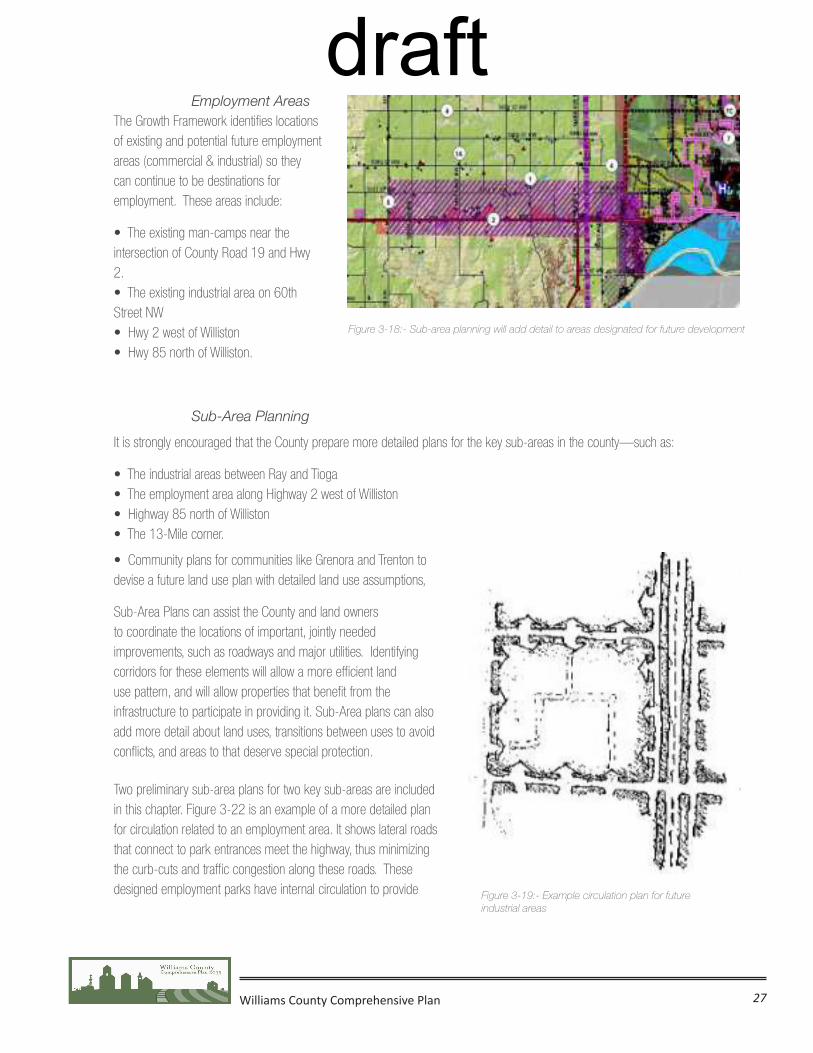
Williams County Comprehensive Plan 27
Employment AreasThe Growth Framework identifies locations of existing and potential future employment areas (commercial & industrial) so they can continue to be destinations for employment. These areas include:
• The existing man-camps near the intersection of County Road 19 and Hwy 2.• The existing industrial area on 60th Street NW• Hwy 2 west of Williston• Hwy 85 north of Williston.
Sub-Area Planning
It is strongly encouraged that the County prepare more detailed plans for the key sub-areas in the county—such as:
• The industrial areas between Ray and Tioga• The employment area along Highway 2 west of Williston• Highway 85 north of Williston• The 13-Mile corner.
• Community plans for communities like Grenora and Trenton to devise a future land use plan with detailed land use assumptions,
Sub-Area Plans can assist the County and land owners to coordinate the locations of important, jointly needed improvements, such as roadways and major utilities. Identifying corridors for these elements will allow a more efficient land use pattern, and will allow properties that benefit from the infrastructure to participate in providing it. Sub-Area plans can also add more detail about land uses, transitions between uses to avoid conflicts, and areas to that deserve special protection.
Two preliminary sub-area plans for two key sub-areas are included in this chapter. Figure 3-22 is an example of a more detailed plan for circulation related to an employment area. It shows lateral roads that connect to park entrances meet the highway, thus minimizing the curb-cuts and traffic congestion along these roads. These designed employment parks have internal circulation to provide
Figure 3-18:- Sub-area planning will add detail to areas designated for future development
Figure 3-19:- Example circulation plan for future industrial areas
draft
Recommended