Configuring ArcGIS Enterprise
in Disconnected EnvironmentsBILL MAJOR

Disconnected Environments
• How many of you run disconnected today, i.e. no internet access?
• Many customers run ArcGIS Enterprise with no access to internet resources.
- No access to AGOL Base Maps
- No access to http://js.arcgis.com
- No access to lots of cool stuff, e.g. GeoEnrichment Services or Living Atlas Layers
• Security often dictates running disconnected environments.
• Disconnected environments create unique challenges that need to be addressed in
order to take full advantage of on-premises Web GIS with ArcGIS Enterprise.
Not everyone has internet access?

Agenda
• Portal for ArcGIS On-premises Services
• Portal for ArcGIS Back-end
• Security
• Configuring Apps
Disconnected Environment Considerations
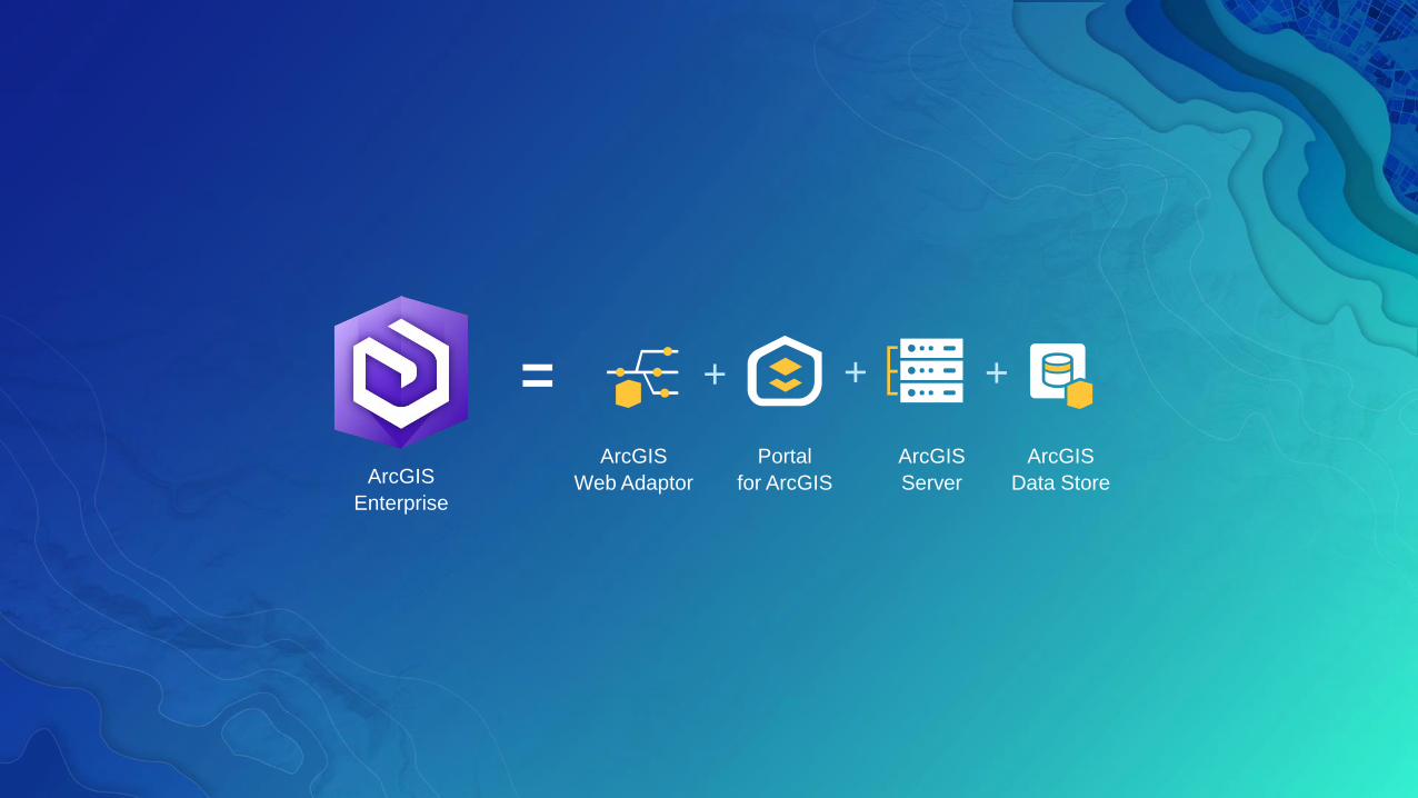
+=
ArcGIS
Enterprise
Portal
for ArcGIS
ArcGIS
Server
ArcGIS
Data Store
+
ArcGIS
Web Adaptor
+

+=
ArcGIS
Enterprise
Portal
for ArcGIS
ArcGIS
Server
ArcGIS
Data Store
+
ArcGIS
Web Adaptor
+

+=
ArcGIS
Enterprise
Portal
for ArcGIS
ArcGIS
Server
ArcGIS
Data Store
+
ArcGIS
Web Adaptor
+
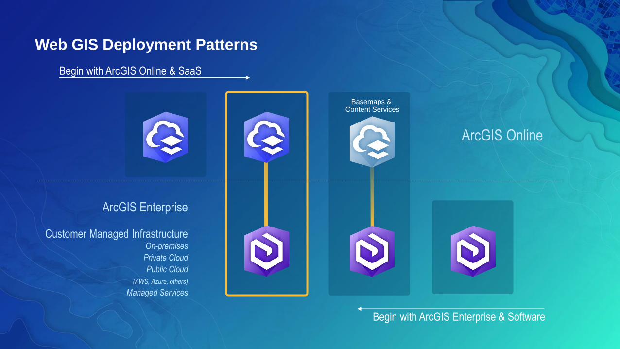
Begin with ArcGIS Online & SaaS
ArcGIS Enterprise
Customer Managed InfrastructureOn-premises
Private Cloud
Public Cloud
(AWS, Azure, others)
Managed Services
ArcGIS Online
Begin with ArcGIS Enterprise & Software
Web GIS Deployment Patterns
Basemaps & Content Services

Friendly reminder before you get started…..
• Download all the software installers and data products from My Esri
- Windows vs. Linux
- ArcGIS Server, Portal for ArcGIS, Web Adaptor, ArcGIS Data Store,
License Manager, ArcGIS Pro, ArcGIS Desktop, lasted JSAPI 3.x and 4.x,
ArcGIS Maps for Office Portal Resources, etc.
- Living Atlas Boundary Layers
• Get licenses that you will need
- Server Roles, Portal named users, Insight Users, etc.
• Consider open source downloads from http://esri.github.io/
- Ago-assistant
Disconnected environment preparation steps

Portal for ArcGIS
On-premises Services

Custom Basemaps for ArcGIS Enteprise
• Add a cached service to Portal map viewer
• Save Web Map as a new item and share with Everyone
• Add item to a custom public group
• Select custom group in the Basemap gallery option and select a default Basemap
• Esri Commercial Data Appliance (CDA) offers AGOL Basemap capabilities
Basemaps
Where will your Basemaps come from?

Enabling On-premises Utility Services in Portal
• There are a number of Portal Utility Services that bring a lot of functionality
to your on-premises Portal. Some of them include:
- Printing – Enable ArcGIS Server Print Service to use the Export Web Map Task.
- Geocoding - ArcGIS Online World Geocode Service is unavailable in
disconnected environments
- Utilize Esri Streetmap Premium Geocode Services published on-premises
- World Geocode Service on-premises
- Custom Geocoding Service
- Geometry – Utilize the Geometry Services of an on-premises ArcGIS Server
- Routing – ArcGIS Online Routing Service is unavailable in disconnected
environments.
- Utilize Esri Streetmap Premium Routing Services published on-premises
- Custom Routing Service
- Analysis Utility Services, e.g. Hydrology, Elevation, and Network

Portal for ArcGIS Back-end
Considerations

config.js
• Located at <Portal Install
Directory>\customizations\10.5.1\webapps\arcgis#home\js\arcgisonline
• Detailed in the Portal Administrator Help
• Provides additional configuration of the Portal UI
• You may want to do this if you're configuring a disconnected deployment or
modifying the portal's behavior to match the requirements of your organization
• Use extreme caution when editing; always make a backup!
• Note: Not maintained (but not overwritten) in an upgrade
- Will need to reapply edits after upgrade
What is this?

config.js
• Set the extentService
• Add Security Classification Banners
• Add Footer Links
• Restrict My Organization page to Portal Admins only
• Enable/Disable Show Social Media Links
• Enable/Disable search ArcGIS Online
Important Settings for Disconnected Environments

Editing config.js file properties
Portal Advanced Customization
Demo

Updating which Language Content Appears in Search Results
• How often have you searched for “Streets” and seen
the following?
• At 10.4 and later, organizations can hide from search
results all language content not relevant to their
organization.
• Provides the added benefit of removing many default
Portal items that have external URLs that are
inaccessible in disconnected environments.

Updating which Language Content Appears in Search Results
• Use Portal Administrator API to update

• ArcGIS Pro is licensed with Portal for ArcGIS + ArcGIS License Manager
• Setup:
1. In ArcGIS License Manager,
- Configure with license file (.lic) → obtained from My.Esri.com
- Generate a Portal configuration file (.json) from license file
2. In Portal Administrator Directory,
- Import Portal configuration file
- https://portal.domain.com:7443/arcgis/portaladmin
3. Use Portal to manage ArcGIS Pro licenses to Named Users
- New controls available on My Organization page
Licensing ArcGIS Pro with Portal for ArcGIS

Security
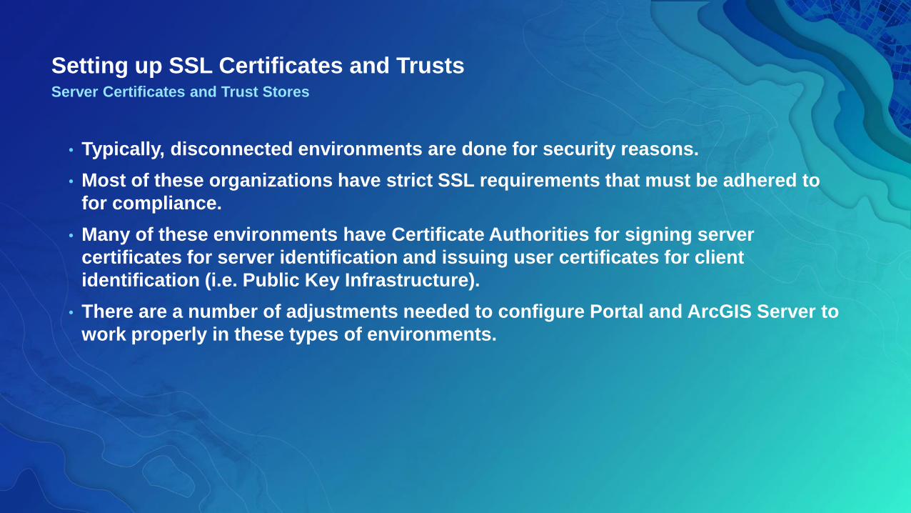
Setting up SSL Certificates and Trusts
• Typically, disconnected environments are done for security reasons.
• Most of these organizations have strict SSL requirements that must be adhered to
for compliance.
• Many of these environments have Certificate Authorities for signing server
certificates for server identification and issuing user certificates for client
identification (i.e. Public Key Infrastructure).
• There are a number of adjustments needed to configure Portal and ArcGIS Server to
work properly in these types of environments.
Server Certificates and Trust Stores

Setting up SSL Certificates and Trusts
• Portal for ArcGIS and ArcGIS Server install self-signed certificates to support ports
7443 and 6443, respectively.
• Consuming services from self-signed certificates is highly discouraged.
• To overcome this, install separate Web Adaptors for Portal and ArcGIS Server and
SSL-enable your web server.
• Users only communicate with Web Server over 443.
Server Certificates and Trust Stores
ArcGIS
Server
Portal for
ArcGIS
CA Signed
SSL Certificate
https://webserver.com
6443
7443
/portal
/server
Setting up SSL Certificates and Trusts
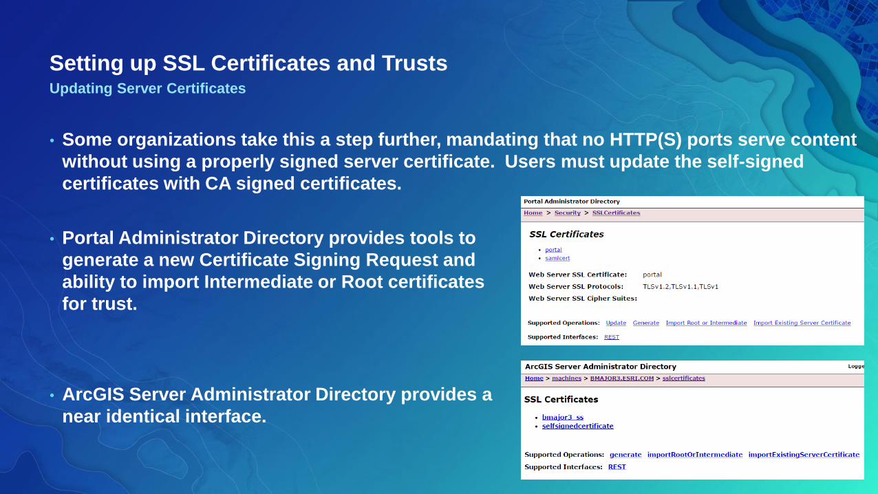
• Some organizations take this a step further, mandating that no HTTP(S) ports serve content
without using a properly signed server certificate. Users must update the self-signed
certificates with CA signed certificates.
Updating Server Certificates
• Portal Administrator Directory provides tools to
generate a new Certificate Signing Request and
ability to import Intermediate or Root certificates
for trust.
• ArcGIS Server Administrator Directory provides a
near identical interface.
Configuring Apps

Living Atlas of the World
Esri curated set of ready-to-use content
It includes both Esri published and user published content

Living AtlasTypes of Content
• Live Content: Hosted in ArcGIS Online
- Items are installed in Portal but item URLs reference Online
- Internet connection is required for access
- Read-only content
- Data types (web maps, apps, scenes and layers)
• Local Content: Hosted in Portal for ArcGIS
- Boundary layers service definition files (by country)
- Download from MyEsri or request DVD
- Publish to Portal as hosted feature services
- Run analysis in Insights for ArcGIS or Portal
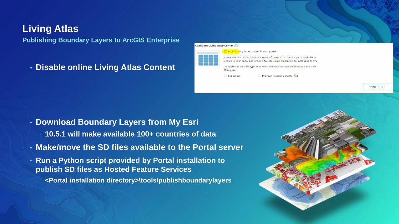
Living AtlasPublishing Boundary Layers to ArcGIS Enterprise
• Disable online Living Atlas Content
• Download Boundary Layers from My Esri
- 10.5.1 will make available 100+ countries of data
• Make/move the SD files available to the Portal server
• Run a Python script provided by Portal installation to
publish SD files as Hosted Feature Services
- <Portal installation directory>\tools\publishboundarylayers

Publishing Boundary Layers
Demo

Deploying Esri JSAPI On-Premises
• Portal 10.5.1 comes with JSAPI 3.20 and 4.3 – can use this as needed
• 3.21 and 4.4 just released!
• Download from https://developers.arcgis.com/downloads/
- Download the API and Documentation
• Deploy to your own web server following the Help Documentation
• Use to:
- Update links in Web Application Templates
- On-premises JSAPI web development
- ArcGIS Server REST Handlers

Deploying Esri JS API
Demo

Web Application Template Downloads
• If you download Web Application Template to host on your
own web server, the source code links point to
http(s)://js.arcgis.com.
• Update links to on-premises installation of the Esri JS API
or Portal’s JS API.
- Note that version of API should be maintained
• Point to your Portal in config files
• Publish/Preview of Web Application Templates within Portal
work as-is, since Portal deploys with its own internal
version of the JSAPI.
• Some have links to Elevation and Geometry Services that
will need to be updated also.
Update JSAPI Links

Web Application Template DownloadsExample Update
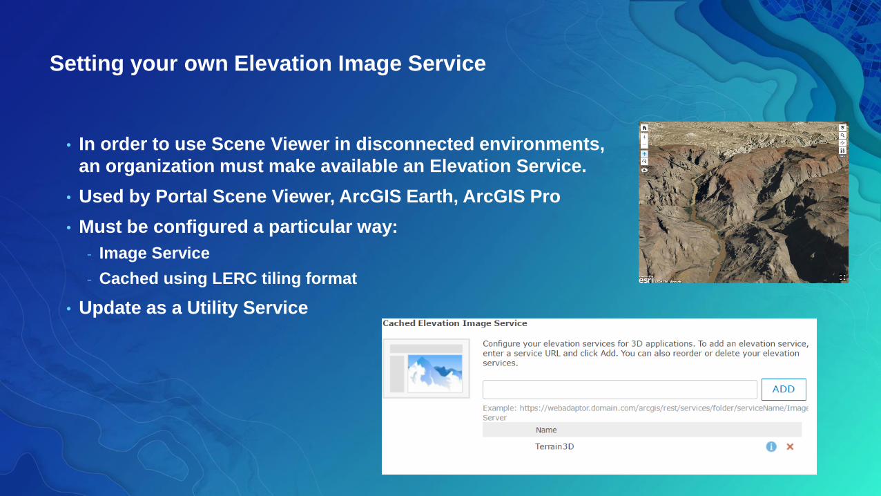
Setting your own Elevation Image Service
• In order to use Scene Viewer in disconnected environments,
an organization must make available an Elevation Service.
• Used by Portal Scene Viewer, ArcGIS Earth, ArcGIS Pro
• Must be configured a particular way:
- Image Service
- Cached using LERC tiling format
• Update as a Utility Service
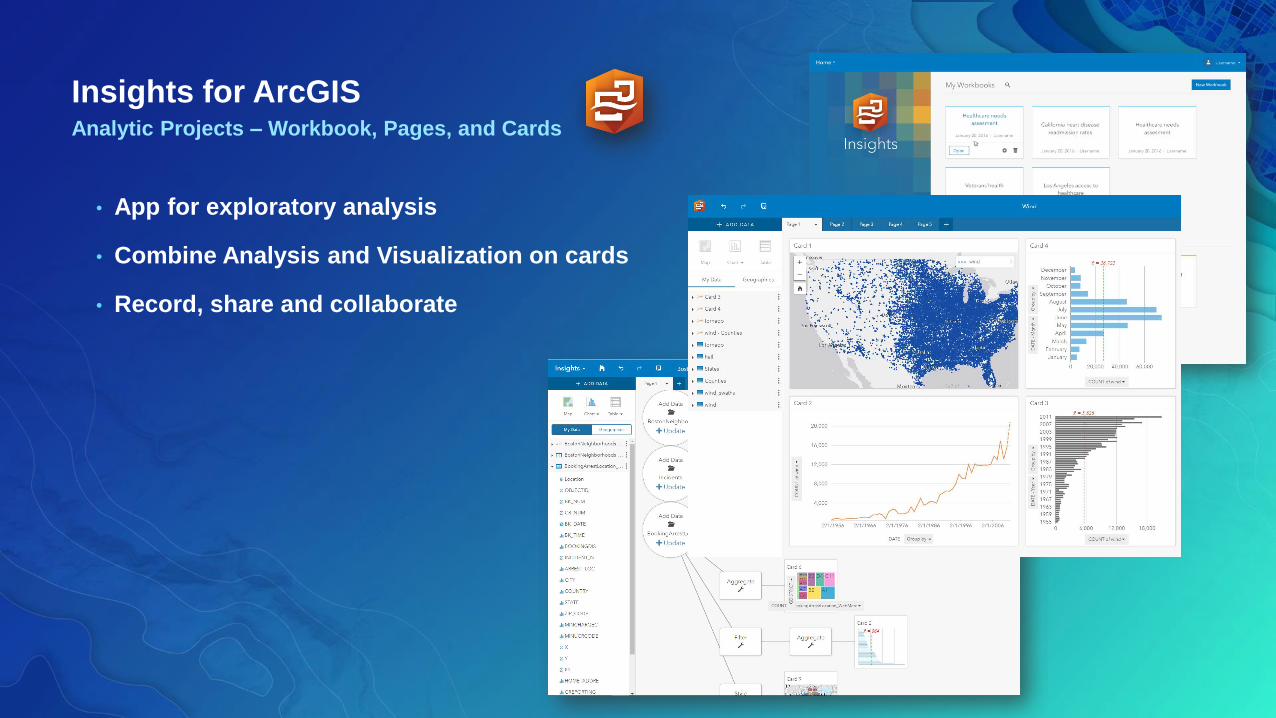
Insights for ArcGISAnalytic Projects – Workbook, Pages, and Cards
• App for exploratory analysis
• Combine Analysis and Visualization on cards
• Record, share and collaborate

Insights for ArcGISDeployment
• Requires ArcGIS Enterprise 10.5.x
• Install on Portal for ArcGIS machine
- *if working in a distributed environment run on hosting
server as well
- **** Make sure to highlight that it’s only 1 installer
• Configure Insights for ArcGIS license (.json) via Portal
Admin
• Provision licenses to users via Portal for ArcGIS

Operations Dashboard Deployment Utility (10.3.4)
• Step 1 - Preparations
- Download and extract deployment utility from “My Esri”
- Have security certificate ready
- Know your Portal URL
- Have write access to Portal’s \apps\dashboard-win folder
• Step 2 – Run deployment utility
• Step 3 – Deploy to Portal
- Copy output folder from step 2 to Portal’s \apps\dashboard-win
folder ****** consider putting needs to be a server admin
- Create an application item of Operations Dashboard
Enable ability to download/open Windows client from Portal

ArcGIS Maps for Office with a Disconnected Portal
• For disconnected Portal deployments, requires resource files
- Separate download, need to install on Portal machine
http://www.esri.com/software/arcgis/arcgisonline/apps/download

Web AppBuilder Developer Edition Disconnected
• Deploy a local JSAPI for 3.x and 4.x
• Need a local Geometry Service enabled on an ArcGIS Server
• Change env.js and config.json files to point to these local resources
• ArcGIS Blog posting
https://blogs.esri.com/esri/arcgis/2016/11/02/deploying-web-appbuilder-for-arcgis-developer-edition-in-a-
disconnected-portal-for-arcgis-environment/

Questions?

Other Relevant Sessions
• ArcGIS Enterprise: Architecture Best Practices
- Tuesday 10:30am
• High Availability and Disaster Recovery for ArcGIS Enterprise
- Tuesday 8:30am, Thursday 3:15pm
• Web GIS: Architectural Patterns and Practices
- Tuesday 10:15am, Thursday 10:15am
• ArcGIS Enterprise Security: An Introduction
- Tuesday 10:15am, Thursday 8:30am
• ArcGIS Enterprise Security: Advanced Topics
- Tuesday 1:30pm, Thursday 10:15am
• Building Security into Your System
- Tuesday 4:30pm
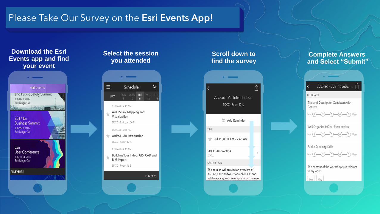
Please Take Our Survey on the Esri Events App!
Select the session you attended
Scroll down to find the survey
Complete Answersand Select “Submit”
Download the Esri Events app and find
your event

Recommended