Community Coordination Meeting Hampden County, Massachusetts
Review of Preliminary Flood MapsMay 31, 2012

Agenda Welcome and Introductions
Mapping Process
Paper versus Digital Flood Insurance Rate Maps
Development of Flood Hazard Data
Public Review and Appeal Period
Effect on Existing Letters of Map Change
Resilience Meeting
Community Adoption Process
Flood Insurance
Questions

Process for Flood Mapping Projects
Release ofPreliminary
DFIRM
Review and Appeal Period for Preliminary
DFIRM
Appeals andComment Resolution
leading to Letter Of Final
Determination(LFD)
ProjectedEffective Date
Of Final DFIRM
Mapping Studies
April 20, 2012 3 Months June 2013/ July 2013
Oct 2011 – March 2012
HampdenCountyScopingStudy
O U T R E A C H
We are Here
Projected LFD Date Dec
2012/Jan 2013
Flood Mapping Project Phases
DFIRM = Digital Flood Insurance Rate Maps
ProjectKick-offMeeting

Digital Flood Insurance Rate Map (DFIRM)
DFIRM=
Flood DataAerial PhotoBase Map
+ Topography +
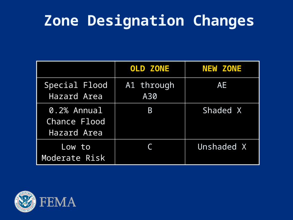
Zone Designation Changes
OLD ZONE NEW ZONE
Special Flood Hazard Area
A1 through A30 AE
0.2% Annual Chance Flood Hazard Area
B Shaded X
Low to Moderate Risk
C Unshaded X

• Previous FIRM referenced to NGVD29*
• Conversion to NAVD88**
Required by FEMA for new DFIRMs
*National Geodetic Vertical Datum of 1929
**North American Vertical Datum of 1988
Conversion Factor for Hampden County = -0.67 feet
(100.00 feet NGVD = 99.33 feet NAVD) rounded
Datum Conversion

Benchmarks
• Obtained from National Geodetic Survey website
• FEMA requires that Benchmarks posses stability of C or higher
• Some benchmarks shown on old FIRMs may not possess stability of C or higher and thus won’t be shown on the new DFIRMs
NGS Benchmarks
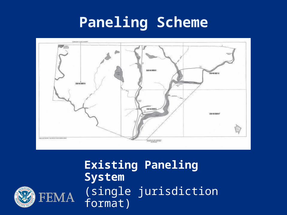
Paneling Scheme
Existing Paneling System(single jurisdiction format)

New Paneling Scheme
New Paneling System
(County-wide format )Based on USGS
quadrangles

Study Update MethodologiesLevels of Study
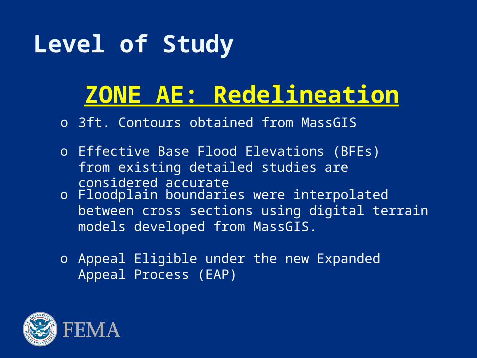
Level of Study
o Effective Base Flood Elevations (BFEs) from existing detailed studies are considered accurate
ZONE AE: Redelineation
o Floodplain boundaries were interpolated between cross sections using digital terrain models developed from MassGIS.
o Appeal Eligible under the new Expanded Appeal Process (EAP)
o 3ft. Contours obtained from MassGIS

MYTHS!
If my community does not have new or revised base flood elevations (BFEs) then my flood hazard areas have not changed.
If the elevation number shown on my old map is different from elevation number on my new map, my BFE has changed. CHECK DATUM CONVERSION FIRST!
Redelineation example:
AE (29) AE (28)
Effective Maps 2012 Preliminary Maps
BFE = 28.9 NGVD29 BFE = 28.2 NAVD88
NGVD = National Geodetic Vertical DatumNAVD = North American Vertical Datum

o Provides an approximate delineation for the 1% annual chance (100 year-flood) event.
o Appeal Eligible under the new Expanded Appeal Process (EAP)
ZONE A: Approximate Study
o Regression equations from USGS to determine flood discharge, WINTR-20 program dated March 2009, and USGS stream gage analysis.
o Cross-section values derived from HEC-RAS. No Field Survey.
Level of Study
o HEC-RAS modeling used for hydraulics

Planning

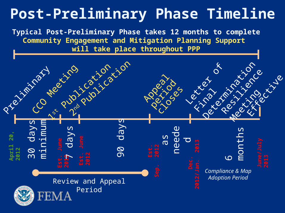
Post-Preliminary Phase TimelineTypical Post-Preliminary Phase takes 12 months to completeCommunity Engagement and Mitigation Planning Support
will take place throughout PPP
Prelim
inar
y
1st P
ublic
ation
2nd Pub
licat
ion
30 d
ays
min
imum
90 d
ays
Appea
l pe
riod
close
s
as
need
ed
Effect
ive
6 m
onth
s
Lette
r of F
inal
Deter
min
atio
n
Jun
e/Ju
ly
201
3
Est
. Ju
ne
201
2
Est
. Ju
ne
201
2
E
st.
Sep
. 2
012
D
ec.
201
2/J
an.
201
3
Ap
ril
20,
201
2
Review and Appeal Period
Resilie
nce
Mee
ting
CCO M
eetin
g
Compliance & Map Adoption Period
7 da
ys

Discover the CommunitiesUnderstand local interest, issues, capabilities of communities
Status of Mitigation Plan Communication desire, skills, resources Interest in and resources for mitigation Experience with flood disasters and recovery Floodplain administration Interest in cost-share Mitigation support needs and interests
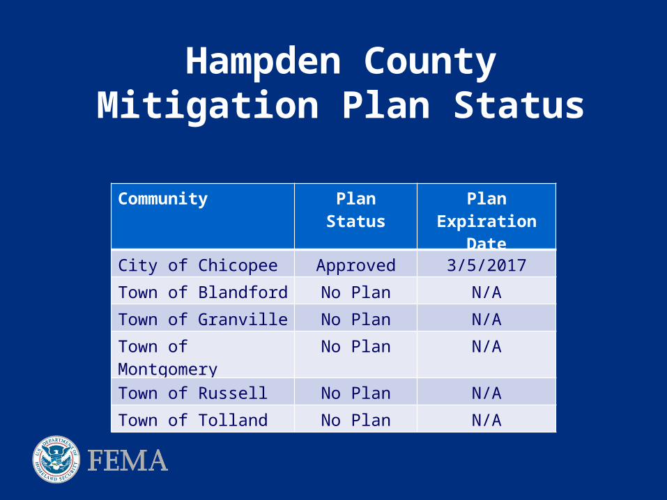
Hampden CountyMitigation Plan Status
Community Plan Status Plan Expiration Date
City of Chicopee Approved 3/5/2017
Town of Blandford No Plan N/A
Town of Granville No Plan N/A
Town of Montgomery No Plan N/A
Town of Russell No Plan N/A
Town of Tolland No Plan N/A

Discover FEMA Programs
Flood Mitigation Assistance – annual funding to reduce risk to NFIP-insured structures
Hazard Mitigation Grant Program – declared disaster funding for long-term hazard mitigation measures
Pre-Disaster Mitigation Program – annual funding for hazard mitigation planning and implementation
Repetitive Flood Claims - annual funding to reduce risk to NFIP-insured structures with one or more claims
Severe Repetitive Loss – annual funding to reduce risk to NFIP-insured severe repetitive loss structures
Community Rating System – proactive communities receive insurance discounts for residents

Post-Preliminary Processing
Post-Preliminary Phase TimelineTypical Post-Preliminary Phase takes 12 months to completeCommunity Engagement and Mitigation Planning Support
will take place throughout PPP
Prelim
inar
y
1st P
ublic
ation
2nd Pub
licat
ion
30 d
ays
min
imum
90 d
ays
Appea
l pe
riod
close
s
as
need
ed
Effect
ive
6 m
onth
s
Lette
r of F
inal
Deter
min
atio
n
Jun
e/Ju
ly
201
3
Est
. Ju
ne
201
2
Est
. Ju
ne
201
2
E
st.
Sep
. 2
012
D
ec.
201
2/J
an.
201
3
Ap
ril
20,
201
2
Review and Appeal Period
Resilie
nce
Mee
ting
CCO M
eetin
g
Compliance & Map Adoption Period
7 da
ys
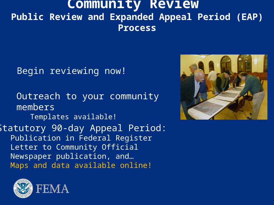
Community Review Public Review and Expanded Appeal Period (EAP) Process
Begin reviewing now!
Outreach to your community membersTemplates available!
Statutory 90-day Appeal Period:Publication in Federal RegisterLetter to Community OfficialNewspaper publication, and…Maps and data available online!

Website
http://www.starr-team.com/starr/RegionalWorkspaces/RegionI/HampdenCountyMA/Preliminary%20Maps/Forms/AllItems.aspx

Expanded Appeal Period (EAP) ProcessThe Facts
New process detailed in Procedure Memorandum issued to the public by FEMA on December 1, 2011
What’s the same?
An appeal must be based on data that shows the flood hazard information is scientifically or technically incorrect
What’s different?
Anything that may have an impact on flood insurance requirements will now be given the same 90-day appeal period!

Expanded Appeal Period (EAP) Process Appeals versus Comments under the new EAP process
Appeals :
Areas showing new or revised Base Flood Elevations (BFEs) or Zone AO depths
Areas showing new or revised Special Flood Hazard Area (SFHA) boundaries (including both increases and decreases in the extent of the SFHA)
Areas where there is a change in SFHA zone designation
Areas showing new or revised regulatory floodway boundaries (including both increases and decreases in the extent of the regulatory floodway)

Expanded Appeal Period (EAP) Process Appeals versus Comments under the new EAP process
Comments:
Corporate limit revisions
Road name errors and revisions
Flooding source name errors and revisions
Base map errors
Other possible omissions or potential
improvements to the mapping

“The Expanded Appeal Period (EAP) means I have more time to submit an appeal.” NO
“The 90- day appeal/comment period is my only chance to change FEMA’s maps?” NO
“What are my other options?” Letters of Map Amendment (LOMA): A request to FEMA for
removal of individual properties or structures from the SFHA Letters of Map Revision (LOMR): A request to FEMA to modify an
effective Flood Insurance Rate Map (FIRM), or Flood Boundary and Floodway Map (FBFM), or both. Results in the modification of the floodway, BFEs, or the Special Flood Hazard Area (SFHA).
MYTHS!

Appeal Eligible Communities (New or Modified Floodplains)
Post-Preliminary Processing
Town of BlandfordCity of ChicopeeTown of Granville
Town of MontgomeryTown of RussellTown of Tolland
NOTE: ALL communities may review and submit comments during the 90-day time period

Summary of Map Actions (SOMA) Background
Letters of Map Change (LOMCs) are legally binding changes to the map
Summary of Map Actions is an assessment of all existing LOMCs compared with the new FEMA maps
Post-Preliminary Processing

Category 1: shown on the new DFIRM panel
Category 2: NOT shown on the new DFIRM panel due to scale limitations (revalidated after the new DFIRMs become effective)
Category 3: superseded, and no longer valid, due to revised flood hazards
Category 4: property owner must request this be re-determined
Summary of Map Actions (continued)

Revalidation of Letters of Map Change (LOMCs)
The Summary of Map Actions (SOMA) is used to generate a Revalidation Letter
The Revalidation Letter is issued to the community
Community officials are encouraged to disseminate this information.
Post-Preliminary Processing

Revalidation Letter Distribution
Community FEMA Regional Office State NFIP Coordinator LOMC Compendium NOT to Homeowners or Developers IS available through Map Service Center:
http://msc.fema.gov/
Post-Preliminary Processing

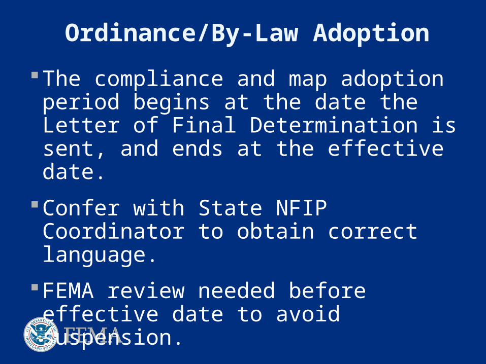
The compliance and map adoption period begins at the date the Letter of Final Determination is sent, and ends at the effective date.
During the compliance and map adoption period, community officials review and, if appropriate, revise the community’s floodplain ordinances to ensure they are compliant with NFIP regulations (important!).
To avoid suspension from the NFIP, the community must adopt a compliant floodplain management ordinance and submit its ordinance to the FEMA Regional office (through the NFIP State Coordinator’s Office) for approval prior to the end of the compliance and map adoption period.
Post-Preliminary Processing

Resilience Meeting Focus on hazard mitigation plan implementation
Discuss floodplain management practices
Examine areas of higher risk and highlight resources available
Identify specific mitigation projects
Identify areas of concentrated insurance claims/LOMCs (Collect and document any unmet needs)
Provide compliance/adoption information
Flood Insurance Implications from Flood Maps

Floodplain Management & Insurance
Adoption
Floodplain Management
Flood Insurance
The compliance and map adoption period begins at the date the Letter of Final Determination is sent, and ends at the effective date.
Confer with State NFIP Coordinator to obtain correct language.
FEMA review needed before effective date to avoid suspension.
Ordinance/By-Law Adoption

Floodplain Management
Understanding your risk
Knowing where you’re vulnerable
Natural functions of Floodplains

Flood Insurance:Three Main Items to Remember
Facts about Flood Insurance
Impacts
Grandfathering/PRP

Flood Insurance is required if you live in a Special Flood Hazard Area (SFHA) or high-risk area and have a federally backed mortgage
Flood insurance is available for those who live outside the SFHA (low or moderate risk area), and is usually available at a much reduced cost!
People outside of high-risk areas file over 20% of NFIP claims and receive one-third of disaster assistance for flooding.
A lender can require flood insurance, even if it is not federally required.
You can purchase flood insurance through your normal insurance agent or company
Facts About Flood Insurance

Mapped “In” Flood risk increased/better
data
More structures in floodplain
Mandatory purchase of flood insurance
Mapped “Out” Risk not eliminated
Low-cost preferred risk coverage available Keep coverage Lower cost
39
Impacts
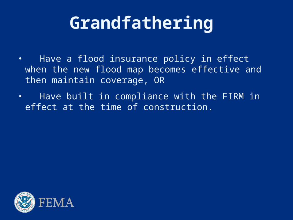
Grandfathering
• Have a flood insurance policy in effect when the new flood map becomes effective and then maintain coverage, OR
• Have built in compliance with the FIRM in effect at the time of construction.

Grandfathering Rule: Pre-FIRM(For structures built before the initial FIRM)
Continuous coverage
Substantially Improved Structures

Grandfathering Rule: Post-FIRM(For structures built after the initial FIRM)
Purchasing a policy before the new FIRM becomes.
Purchasing a policy after the new FIRM becomes effective.

Preferred Risk Policy (PRP)Owners are eligible to receive up to two
policy years of reduced premiums after a map revision.
PRP is also available to people in minimal risk zone

Community Resources
http://www.fema.gov/business/nfip/hillsbo1.shtm

Who do I contact with questions?
For general FEMA mapping and LOMC questions contact FEMA’s Map Information Exchange (FMIX): 1-877-FEMA MAP (1-877-336-2627) or email a Map Specialist: [email protected]
Map Service Center (MSC): where you can view effective maps online for free http://www.msc.fema.gov/
To learn more about the National Flood Insurance Program: http://www.floodsmart.gov/floodsmart/ or call 1-888-379-9531
Points of ContactState Contacts
Richard Zingarelli, NFIP State Coordinator, MA Department of Conservation and Recreation
[email protected] Colleen Bailey, State Flood Hazard Mapping
Coordinator, MA Department of Conservation and Recreation
STARR Regional Service Center Alex Sirotek, RSC Lead, STARR
PLEASE SEND ALL COMMENTS & APPEALS to: Brian Lee, STARR, 6110 Frost Pl, Laurel, MD 20707
Please copy:
David Mendelsohn, FEMA Region 1, 99 High Street, 6 th Floor, Boston, MA 02110
Alex Sirotek STARR, 99 High Street, 3rd Floor, Boston, MA 02110
STARR Hampden County Contacts Buvana Ramaswamy, Task Order
Manager, STARR
[email protected] Brian Lee, Hampden County Project
Manager, STARR
FEMA Contacts Kerry Bogdan, Project Manager and
Senior Engineer, FEMA Region I
[email protected] David Mendelsohn, Post Preliminary
Processing, FEMA Region I
[email protected] Marilyn Hilliard, Senior Planner, Risk
Analysis Branch, FEMA Region I
[email protected] Christopher Markesich, Sr. Nat Hazards
Program Specialist, FEMA Region I

Questions?
Recommended