© 2008 FHNW / IVGI
Combining micro UAV based mobile video imagery and virtual globes – a test case for future sensor web capabilities
Stephan NebikerFHNW University of Applied Sciences Northwestern SwitzerlandInstitute of Geomatics [email protected]
EuroSDR & ISPRS Workshop on Geosensor NetworksHannover, 20-22 February 2008

S. Nebiker: Micro UAV and Virtual Globes, Geosensor WS Hannover, 21.2.2008 2© 2008 FHNW / IVGI
Mobile geosensors (real world) Virtual globes (virtual world)
1. Monitoring real-world events in a virtual world Virtual Monitoring 2. Superimposing the real and virtual world Augmented Monitoring
= research goals of the ViMo (Virtual Monitoring) project
Vision: Monitoring the Real World in a Virtual Globe Environment

S. Nebiker: Micro UAV and Virtual Globes, Geosensor WS Hannover, 21.2.2008 3© 2008 FHNW / IVGI
Outline
1. Small UAVs – The ideal future Geosensor Platforms?
2. Virtual Globes – Live before and after Google Earth …
3. OGC's Sensor Web Enablement (SWE)
4. The i3D Virtual Globe Technology
5. Geosensor Support in i3D – Test Cases for future SWE Capabilities
6. Conclusions and Outlook
S. Nebiker: Micro UAV and Virtual Globes, Geosensor WS Hannover, 21.2.2008 4© 2008 FHNW / IVGI
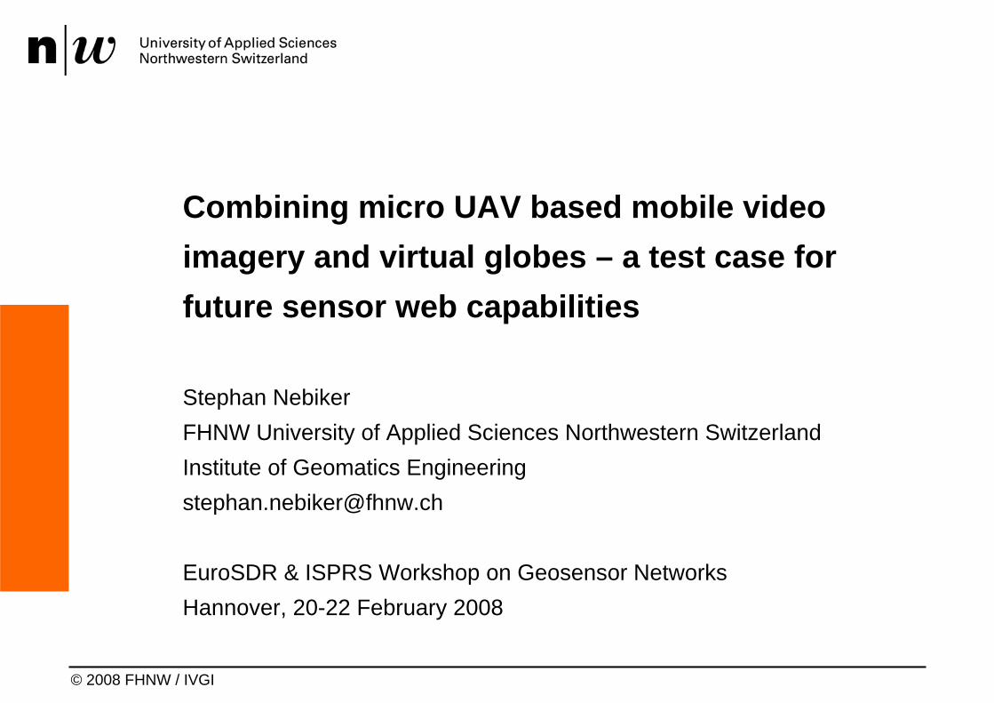
Small to medium UAVs – a booming new technology
Mini and micro UAVs–mini: less than 30 kg
micro: 1 to few kg– legally operational as
'model aircrafts'–GPS/INS flight control–configurations:
quadcopters, fixed wing, helicopters
–propulsion: various, increasingly electrical
© Innosuisse Inc. and SwissCopter AG

S. Nebiker: Micro UAV and Virtual Globes, Geosensor WS Hannover, 21.2.2008 5© 2008 FHNW / IVGI
Small UAVs – Light-weight Imaging Payloads => micro UAVs < 400g (!)
Still Imaging Sensors Video Sensors
Thermal Infrared Sensors (TIR) Multispectral Sensors (MSMS of FHNW)
S. Nebiker: Micro UAV and Virtual Globes, Geosensor WS Hannover, 21.2.2008 6© 2008 FHNW / IVGI
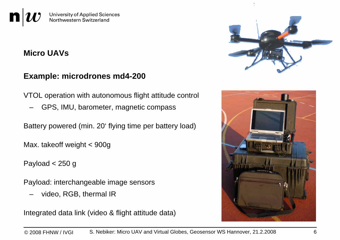
Micro UAVs
Example: microdrones md4-200
VTOL operation with autonomous flight attitude control– GPS, IMU, barometer, magnetic compass
Battery powered (min. 20‘ flying time per battery load)
Max. takeoff weight < 900g
Payload < 250 g
Payload: interchangeable image sensors– video, RGB, thermal IR
Integrated data link (video & flight attitude data)

S. Nebiker: Micro UAV and Virtual Globes, Geosensor WS Hannover, 21.2.2008 7© 2008 FHNW / IVGI
Outline
1. Small UAVs – The ideal future Geosensor Platforms?
2. Virtual Globes – Live before and after Google Earth …
3. OGC's Sensor Web Enablement (SWE)
4. The i3D Virtual Globe Technology
5. Geosensor Support in i3D – Test Cases for future SWE Capabilities
6. Conclusions and Outlook

S. Nebiker: Micro UAV and Virtual Globes, Geosensor WS Hannover, 21.2.2008 8© 2008 FHNW / IVGI
Virtual Globes
Current virtual globe technologies– e.g. Google Earth, Microsoft Virtual Earth
or NASA World Wind
Features– streaming of (very) large terrain data sets– strong support for POI (& 3D objects)– integration with web search technologies
Not (primarily) designed for …– dynamic or real-time content– collaboration scenarios
i3D Virtual Globe Technology (FHNW)

S. Nebiker: Micro UAV and Virtual Globes, Geosensor WS Hannover, 21.2.2008 9© 2008 FHNW / IVGI
Virtual Globes – Typical Contents
DEM digital elevation
models
Orthoimagery
Points of Interest
3D objects
Multimediaobjects

S. Nebiker: Micro UAV and Virtual Globes, Geosensor WS Hannover, 21.2.2008 10© 2008 FHNW / IVGI
Virtual Globes – Live before (and after?) Google Earth
1997/98 Founding of Skyline Software Systems und Viewtec
2000 Founding of GEONOVA (FHNW)
2001 "Flight through Switzerland" (GEONOVA): for the 1st time entire country interactively & 3D in the WWWFounding of Keyhole
2003 Founding of 3D GEO(HPI Potsdam) and GeoTango (York University)ESRI launches ArcGlobe (ca.)
2004 Google buys KeyholeNASA launches World Wind
2005 Launching of von Google EarthLeica launches Virtual ExplorerMicrosoft buys GeoTango
2006 Microsoft launches Virtual Earth (as a virtual globe)IGN (Fr) launches GéoPortail (3D)
2008 Many European pioneers in virtual globe technologies have seized to exist (GEONOVA, Viewtec etc.)

S. Nebiker: Micro UAV and Virtual Globes, Geosensor WS Hannover, 21.2.2008 11© 2008 FHNW / IVGI
Outline
1. Small UAVs – The ideal future Geosensor Platforms?
2. Virtual Globes – Live before and after Google Earth …
3. OGC's Sensor Web Enablement (SWE)
4. The i3D Virtual Globe Technology
5. Geosensor Support in i3D – Test Cases for future SWE Capabilities
6. Conclusions and Outlook
S. Nebiker: Micro UAV and Virtual Globes, Geosensor WS Hannover, 21.2.2008 12© 2008 FHNW / IVGI
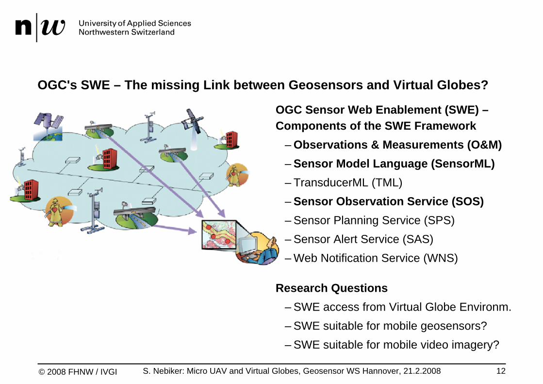
OGC's SWE – The missing Link between Geosensors and Virtual Globes?
OGC Sensor Web Enablement (SWE) –Components of the SWE Framework
– Observations & Measurements (O&M)– Sensor Model Language (SensorML)– TransducerML (TML)– Sensor Observation Service (SOS)– Sensor Planning Service (SPS)– Sensor Alert Service (SAS)– Web Notification Service (WNS)
Research Questions– SWE access from Virtual Globe Environm.– SWE suitable for mobile geosensors?– SWE suitable for mobile video imagery?

S. Nebiker: Micro UAV and Virtual Globes, Geosensor WS Hannover, 21.2.2008 13© 2008 FHNW / IVGI
Sensor Observation Service (SOS) (Status 02/08: Draft Implementation Specification)
The key component of OGC's SWE–Standard web interface for requesting, filtering, and retrieving observations and
sensor system information–Intermediary between client (e.g. Virtual Globe) and
–an observation repository or–a near real-time sensor channel
Profiles and supported requests–Core: GetCapabilities, DescribeSensor, GetObservation–Transactional (optional): RegisterSensor, InsertObservation–Enhanced (optional): GetObservatonById, GetResult, GetFeatureOfInterest,
GetFeatureOfInterestTime, DescribeFeatureType, DescribeObservationType …

S. Nebiker: Micro UAV and Virtual Globes, Geosensor WS Hannover, 21.2.2008 14© 2008 FHNW / IVGI
Outline
1. Small UAVs – The ideal future Geosensor Platforms?
2. Virtual Globes – Live before and after Google Earth
3. OGC's Sensor Web Enablement (SWE)
4. The i3D Virtual Globe Technology
5. Geosensor Support in i3D – Test Cases for future SWE Capabilities
6. Conclusions and Outlook
S. Nebiker: Micro UAV and Virtual Globes, Geosensor WS Hannover, 21.2.2008 15© 2008 FHNW / IVGI
i3D – Virtual Globe Technology
Features–3rd generation geovisualisation engine developed at FHNW–spherical rendering on WGS-84 ellipsoid–highly optimised for current generation GPUs
Content Streams–for terrain, imagery, POI and 3D objects (e.g. city models)–over the network or from local drives–support for very large terrain and imagery data sets
Extensible Architecture–various extension mechanisms / powerful API

S. Nebiker: Micro UAV and Virtual Globes, Geosensor WS Hannover, 21.2.2008 16© 2008 FHNW / IVGI
i3D – Demo
S. Nebiker: Micro UAV and Virtual Globes, Geosensor WS Hannover, 21.2.2008 17© 2008 FHNW / IVGI
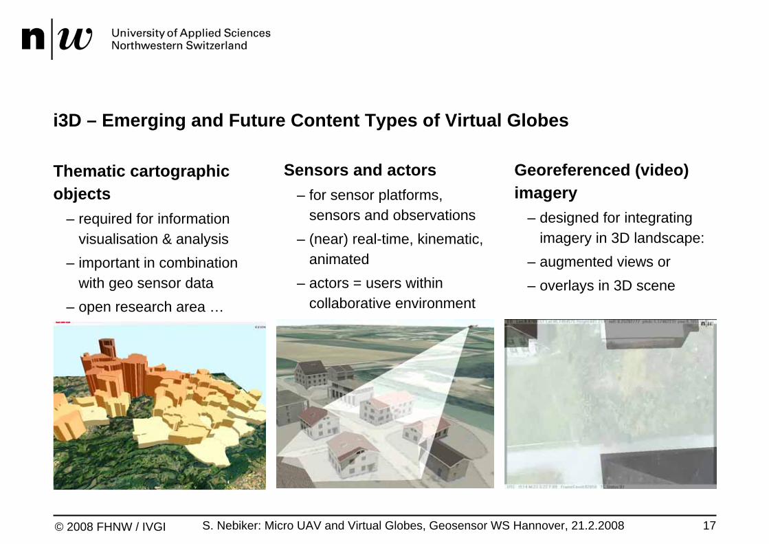
i3D – Emerging and Future Content Types of Virtual Globes
Thematic cartographic objects
– required for information visualisation & analysis
– important in combination with geo sensor data
– open research area …
Sensors and actors– for sensor platforms,
sensors and observations– (near) real-time, kinematic,
animated– actors = users within
collaborative environment
Georeferenced (video) imagery
– designed for integrating imagery in 3D landscape:
– augmented views or– overlays in 3D scene
S. Nebiker: Micro UAV and Virtual Globes, Geosensor WS Hannover, 21.2.2008 18© 2008 FHNW / IVGI
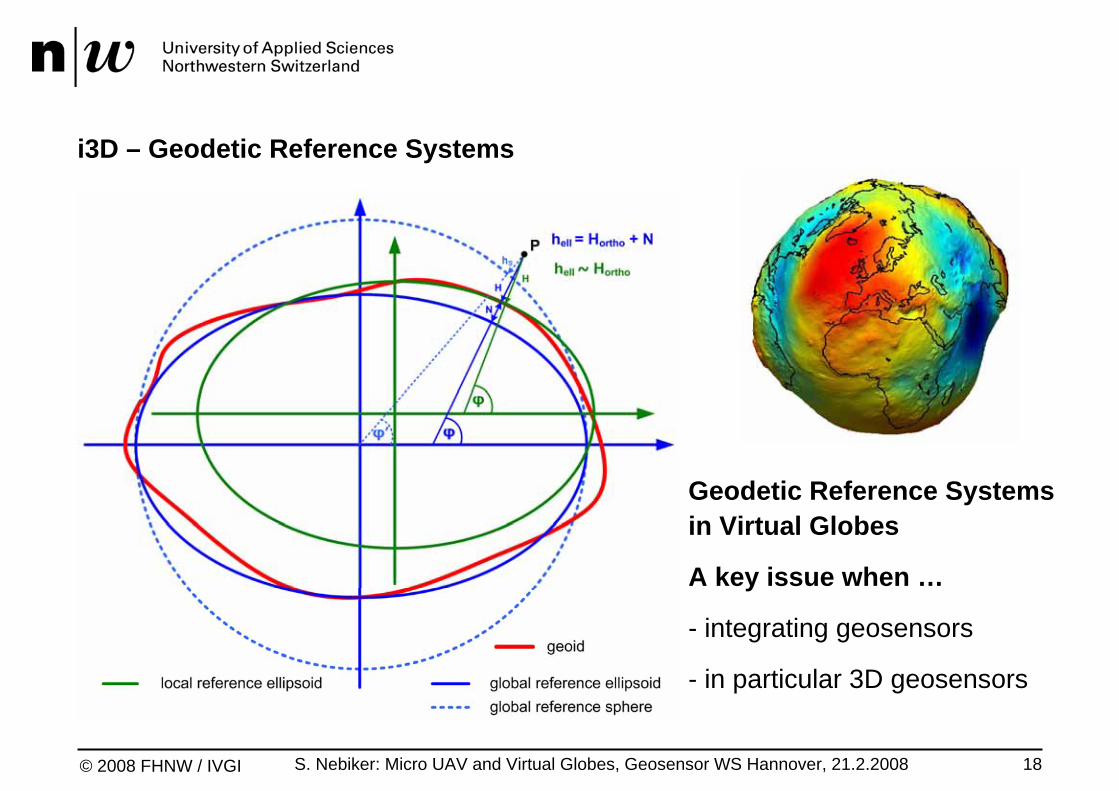
i3D – Geodetic Reference Systems
Geodetic Reference Systemsin Virtual Globes
A key issue when …
- integrating geosensors
- in particular 3D geosensors
S. Nebiker: Micro UAV and Virtual Globes, Geosensor WS Hannover, 21.2.2008 19© 2008 FHNW / IVGI
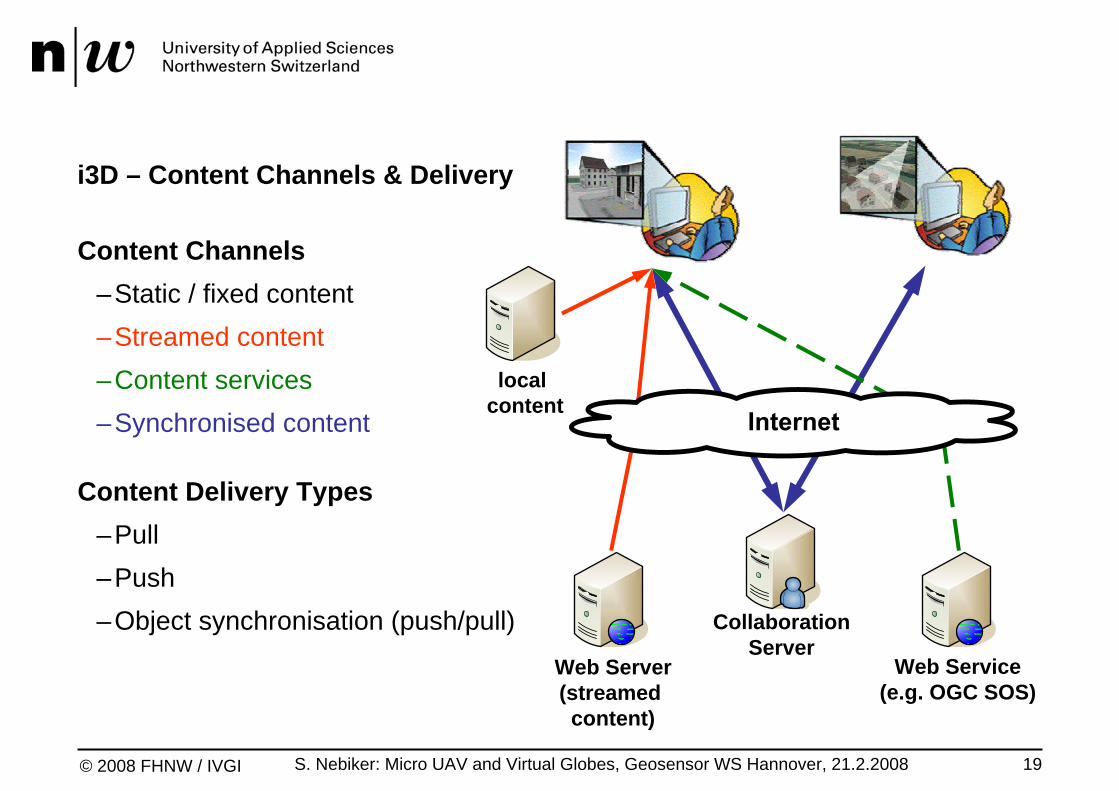
i3D – Content Channels & Delivery
Content Channels–Static / fixed content–Streamed content–Content services–Synchronised content
Content Delivery Types–Pull–Push–Object synchronisation (push/pull) Collaboration
ServerWeb Service
(e.g. OGC SOS)Web Server(streamed content)
local content
S. Nebiker: Micro UAV and Virtual Globes, Geosensor WS Hannover, 21.2.2008 20© 2008 FHNW / IVGI
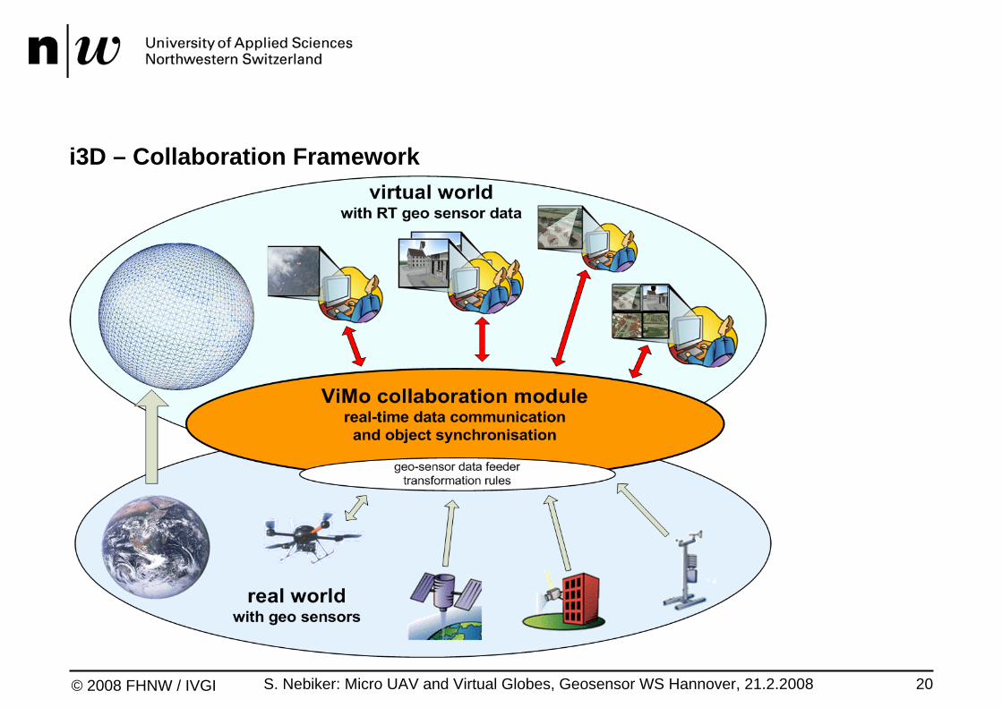
i3D – Collaboration Framework
S. Nebiker: Micro UAV and Virtual Globes, Geosensor WS Hannover, 21.2.2008 21© 2008 FHNW / IVGI
i3D – Collaboration Framework
Main requirements and features–user authentification and collaboration sessions–secure real-time communication for large numbers of users–collaborative geospatial environment (shared virtual globe)–additional communication channels (e.g. chat, video and voice)
Communication Framework–built on top of RakNet network engine (C++ UDP network library)–components: ViMo Session Server, ViMo Connection Broker, ViMo Client–ViMo Connection Broker enables NAT punch-through

S. Nebiker: Micro UAV and Virtual Globes, Geosensor WS Hannover, 21.2.2008 22© 2008 FHNW / IVGI
Application Interfacing & Integration– e.g. HTML via JavaScript
Extensions via i3D Scripting API– Lua Programming Language
Extensions of the 3D Engine– by the i3D Core Team
(normally in C++)
Extensions of the Scene Contents
i3D – Extensible Virtual Globe Technology

S. Nebiker: Micro UAV and Virtual Globes, Geosensor WS Hannover, 21.2.2008 23© 2008 FHNW / IVGI
Outline
1. Small UAVs – The ideal future Geosensor Platforms?
2. Virtual Globes – Live before and after Google Earth
3. OGC's Sensor Web Enablement (SWE)
4. The i3D Virtual Globe Technology
5. Geosensor Support in i3D – Test Cases for future SWE Capabilities
6. Conclusions and Outlook

S. Nebiker: Micro UAV and Virtual Globes, Geosensor WS Hannover, 21.2.2008 24© 2008 FHNW / IVGI
Geosensor Support in i3D – Test Cases and Application Scenarios
OGC Sensor Observation Service–Test case: integration of airport weather service via SOS
Virtual Tracking – Integration of mobile Geosensors–Test case: real-time and post-mission integration of GPS loggers
Virtual Monitoring–Monitoring real-world events in a virtual environment
Augmented Monitoring–Superimposing the real and virtual world
S. Nebiker: Micro UAV and Virtual Globes, Geosensor WS Hannover, 21.2.2008 25© 2008 FHNW / IVGI
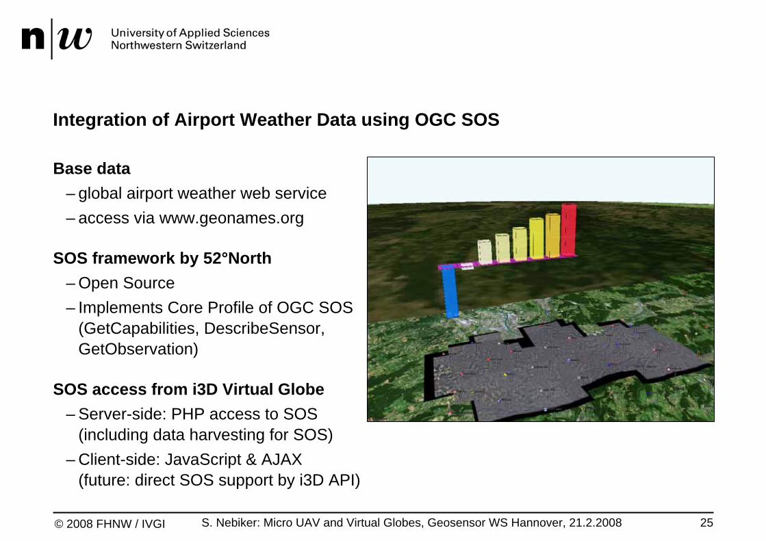
Integration of Airport Weather Data using OGC SOS
Base data– global airport weather web service– access via www.geonames.org
SOS framework by 52°North– Open Source– Implements Core Profile of OGC SOS
(GetCapabilities, DescribeSensor, GetObservation)
SOS access from i3D Virtual Globe– Server-side: PHP access to SOS
(including data harvesting for SOS)– Client-side: JavaScript & AJAX
(future: direct SOS support by i3D API)
S. Nebiker: Micro UAV and Virtual Globes, Geosensor WS Hannover, 21.2.2008 26© 2008 FHNW / IVGI
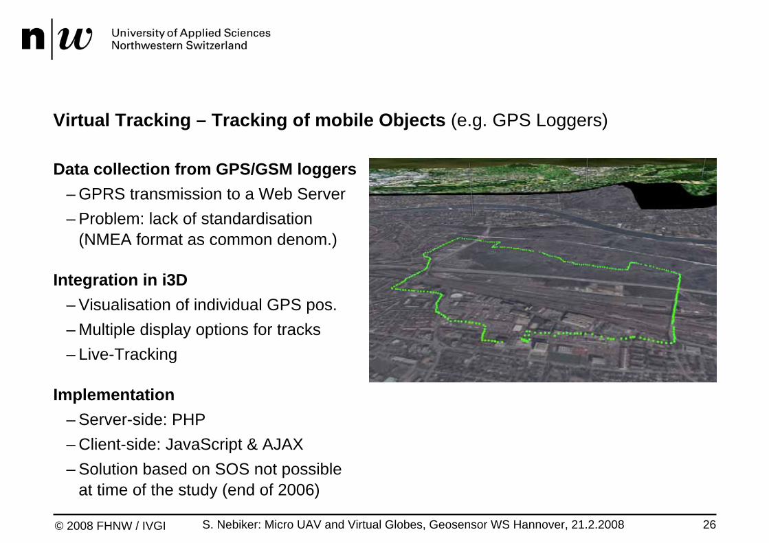
Virtual Tracking – Tracking of mobile Objects (e.g. GPS Loggers)
Data collection from GPS/GSM loggers– GPRS transmission to a Web Server– Problem: lack of standardisation
(NMEA format as common denom.)
Integration in i3D– Visualisation of individual GPS pos. – Multiple display options for tracks– Live-Tracking
Implementation– Server-side: PHP– Client-side: JavaScript & AJAX– Solution based on SOS not possible
at time of the study (end of 2006)
S. Nebiker: Micro UAV and Virtual Globes, Geosensor WS Hannover, 21.2.2008 27© 2008 FHNW / IVGI
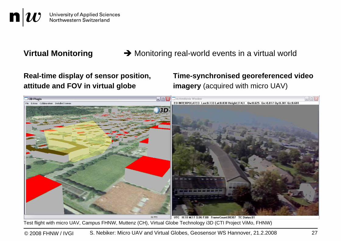
Virtual Monitoring Monitoring real-world events in a virtual world
Real-time display of sensor position, attitude and FOV in virtual globe
Time-synchronised georeferenced video imagery (acquired with micro UAV)
Test flight with micro UAV, Campus FHNW, Muttenz (CH), Virtual Globe Technology i3D (CTI Project ViMo, FHNW)

S. Nebiker: Micro UAV and Virtual Globes, Geosensor WS Hannover, 21.2.2008 28© 2008 FHNW / IVGI
Augmented Monitoring Superimposing the real & virtual world
Augmented video from micro UAV test flight Campus FHNW, Muttenz (CH)
Georeferenced video stream overlaid with 3D landscape model
– mobile platform for video sensor (UAV)– georeferencing of video stream
– GPS time encoding of video stream– direct georeferencing (DG) or– integrated georeferencing (IG) using
3D landscape model informationEugster & Nebiker, MMT'07
– integrated / superimposed rendering of video and virtual globe (i3D)
– integration of geometric and semantic information from the virtual world
S. Nebiker: Micro UAV and Virtual Globes, Geosensor WS Hannover, 21.2.2008 29© 2008 FHNW / IVGI
Service-based Geosensor Integration – (Future) Requirements
Wish list for OGC's SWE architecture and specifications:
geospatial data types and observations (location etc.)
mobile sensors (e.g. fleet management etc.)
multi-sensor platforms
dynamic sensor platforms (e.g. UAVs)
dynamic sensor orientation (gimbals, stabilisation platforms)
georeferenced imagery and video streams

S. Nebiker: Micro UAV and Virtual Globes, Geosensor WS Hannover, 21.2.2008 30© 2008 FHNW / IVGI
Outline
1. Small UAVs – The ideal future Geosensor Platforms?
2. Virtual Globes – Live before and after Google Earth
3. OGC's Sensor Web Enablement (SWE)
4. The i3D Virtual Globe Technology
5. Geosensor Support in i3D – Test Cases for future SWE Capabilities
6. Conclusions and Outlook
S. Nebiker: Micro UAV and Virtual Globes, Geosensor WS Hannover, 21.2.2008 31© 2008 FHNW / IVGI
Conclusions
New mobile geo sensors and geo sensor webVirtual globe as ideal platform for monitoring & tracking real-world phenomena
Mobile geo sensor support in virtual globesGeodetic reference models for (sub-)metre accuracy requiredNew content types: sensors, actors, georeferenced imagery and videoCollaboration functionality for object synchronisation & shared use of VGE
Two generic application scenarios for wide range of applicationsVirtual Monitoring (e.g. object monitoring and tracking)Augmented Monitoring (e.g. rapid / real-time mapping)
First solve the problem(s) and then start to standardise the solution …

S. Nebiker: Micro UAV and Virtual Globes, Geosensor WS Hannover, 21.2.2008 32© 2008 FHNW / IVGI
Outlook – OGC Geo Video Web Service (GVS) (Status: Discussion Paper)
GVS components–Video cameras providing video streams and textual data–Microsoft Windows (?) Media Encoder: MEPG-4 conversion & data encoding–Microsoft Windows (?) Media Server–GVS Database–GVS Web Services–GVS Client–Windows Media Player (?)
First step in the right direction, but …–no support for camera calibration / interior orientation etc.–mobile video sensors & GPS/IMU input mentioned but not yet covered
S. Nebiker: Micro UAV and Virtual Globes, Geosensor WS Hannover, 21.2.2008 33© 2008 FHNW / IVGI
Ongoing and Future Work
Integrated georeferencing Automatic image measurements / image to 3D landscape matchingStreamed 3D contents of virtual globe environment as control information
Move from analog to digital (and HD) videodevelopment of low-weight video encoders for mini and micro UAVsencoding / decoding of sensor position and orientation information…
Collaborative rapid mapping and mission monitoring using small UAVs New CTI project 'UAVision'

© 2008 FHNW / IVGI
Thanks to:Thanks to:CTI Swiss Commission for Technology and InnovationCTI Swiss Commission for Technology and Innovation
FHNW University of Applied SciencesFHNW University of Applied Sciences
Stephan Nebikerwww.fhnw.ch/habg/ivgi
Recommended