United States Department of Agriculture
Appendix H
Coal Unsuitability Criteria Analysis
for the Manti-La Sal National Forest
Draft Forest Plan
Forest Service Intermountain Region September 2020

2
Coal Unsuitability Criteria Analysis for Manti-La Sal National Forest
TABLE OF CONTENTS INTRODUCTION .......................................................................................................................... 3 Criterion Number 1 ......................................................................................................................... 4 Criterion Number 2 ......................................................................................................................... 4
Criterion Number 3 ......................................................................................................................... 5 Criterion Number 4 ......................................................................................................................... 6 Criterion Number 5 ......................................................................................................................... 6 Criterion Number 6 ......................................................................................................................... 7 Criterion Number 7 ......................................................................................................................... 7
Criterion Number 8 ......................................................................................................................... 8 Criterion Number 9 ......................................................................................................................... 8
Criterion Number 10 ....................................................................................................................... 9
Criterion Number 11 ....................................................................................................................... 9
Criterion Number 12 ..................................................................................................................... 10 Criterion Number 13 ..................................................................................................................... 10 Criterion Number 14 ..................................................................................................................... 11
Criterion Number 15 ..................................................................................................................... 11 Criterion Number 16 ..................................................................................................................... 12
Criterion Number 17 ..................................................................................................................... 13 Criterion Number 18 ..................................................................................................................... 14 Criterion Number 19 ..................................................................................................................... 14
Criterion Number 20 ..................................................................................................................... 15
APPENDICES Appendix A: .................................................................................................................................. 16 Appendix B: .................................................................................................................................. 17
Appendix C: .................................................................................................................................. 19 Appendix D: .................................................................................................................................. 21
Appendix E: .................................................................................................................................. 22 Appendix F: .................................................................................................................................. 23
Appendix G: .................................................................................................................................. 24 Appendix H: .................................................................................................................................. 25 Appendix I: ................................................................................................................................... 26
3
Coal Unsuitability Criteria Analysis for Manti-La Sal National Forest
INTRODUCTION
With respect to considering coal resources in land management planning, the Manti-La Sal NF
(Forest) is following direction established in FSH 1909.12 Chapter 20, Section 23.23i (4)(c).
This Forest Service (FS) directive commits the Forest to following established procedures in the
BLM regulations at 43 CFR 3420.1-4, General Requirements for land use planning, where it
states, that the “Department of Agriculture or any other Federal agency with surface
management authority over lands subject to leasing shall prepare comprehensive land use plans
or land use analyses for lands it administers.” Further, FSH 1909.12 chapter 20 also states that,
“Plan components that deal with minerals must be in accord with Agency jurisdiction, applicable
law and Federal regulations, such as coal leasing (43 CFR part 3420).” These regulations
include reviewing the lands to assess where there are areas that may be unsuitable for all or
certain stipulated methods of coal mining per the criteria in 43 CFR 3461. Therefore, for the
purposes of land management planning, the Forest is following established procedures to
evaluate lands with coal development potential that may be unsuitable for coal mining. The coal
unsuitability criteria is also applied at the leasing stage where criteria found in 43 CFR 3461.5 is
applied to a site specific area with potential for coal leasing.
The FS has also entered into an interagency agreement with the Bureau of Land Management
(BLM) to cooperate and coordinate in the application of unsuitability criteria under the general
provisions of the Surface Mining Control and Reclamation Act (SMCRA) of 1977. This 1980
“Memorandum of Understanding (MOU) authorizes the Secretary of Agriculture to assess
whether lands within the National Forest System boundaries are unsuitable for surface coal
mining operations as part of the Federal lands review under Section 522 of the SMCRA. This
delegation is made in order to facilitate the use of surface management agency land use
planning as the integrated method for resource inventory and evaluation; to avoid duplication of
agency efforts and increase efficiency and to assure the systematic application of the
unsuitability criteria, and exceptions, in agency planning that involves a Federal lands review”
For the purposes of land management planning, the Manti-La Sal NF applied unsuitability
criteria to lands with known coal development potential as shown on the attached map, Coal
Development Potential (Appendix A). Data used to create the coal development potential map
was provided by the BLM, Price Field office as per 43 CFR 3420.1-4(e) (1).
Due to thick overburden, the dominant method of mining coal on the Wasatch Plateau has
historically been conducted underground. It is reasonable to assume that any future coal
development will utilize underground methods of coal mining. However, for the purposes of land
management planning, the Manti-La Sal NF has applied the unsuitability criteria to coal
development potential lands with respect to both underground and surface coal mining as surface
facilities may be required for future mine developments.
For the purposes of land management planning the Manti-La Sal NF has also assessed coal
development potential lands with respect to the general exemptions listed below.

4
Coal Unsuitability Criteria Analysis for Manti-La Sal National Forest
The general exemptions to these criteria for underground mining are located in 43 CFR §3461.1,
which state:
(a) Federal lands with coal deposits that would be mined by underground mining methods shall
not be assessed as unsuitable where there would be no surface coal mining operations, as
defined in §3400.0-5 of this title, on any lease, if issued.
(b) Where underground mining will include surface operations and surface impacts on Federal
lands to which a criterion applies, the lands shall be assessed as unsuitable unless the surface
management agency finds that a relevant exception or exemption applies.
The results of the application of unsuitability criteria and exemptions are listed in the assessment
portions of the document in the following text.
Criterion Number 1
All Federal lands included in the following land systems and categories shall be considered
unsuitable: National Park System, National Wildlife Refuge System, National System of Trails,
National Wilderness Preservation System, National Wild and Scenic Rivers System, National
Recreation Areas, lands acquired with money derived from the Land and Water Conservation
Fund, National Forests, and Federal lands in incorporated cities, towns, and villages.
Exceptions. (1) A lease may be issued within the boundaries of any National Forest if the
Secretary finds no significant recreational, timber, economic or other values which may be
incompatible with the lease; and (A) surface operations and impacts are incident to an
underground coal mine, or (B) where the Secretary of Agriculture determines, with respect to
lands which do not have significant forest cover within those National Forests west of the 100th
Meridian, that surface mining may be in compliance with the Multiple-Use Sustained-Yield Act
of 1960, the Federal Coal Leasing Amendments Act of 1976 and the Surface Mining Control and
Reclamation Act of 1977.
Analysis – For the purposes of land management planning, no lands in the coal development
potential area are found to be unsuitable. The underground mining exemption (43 CFR §3461.1)
and criterion exception would apply, pending further analyses, for underground mining and the
surface effects incident to underground mining.
In the Surface Mining Control and Reclamation Act significant forest cover means an existing
plant community consisting predominantly of trees and other woody vegetation. The Secretary of
Agriculture shall decide on a case-by-case basis whether the forest cover is significant within
those national forests west of the 100th meridian) at the time site-specific leases are evaluated
Criterion Number 2
Federal lands that are within rights-of-way or easements or within surface leases for residential,
commercial, industrial, or other public purposes, on federally owned surface shall be considered
unsuitable.

5
Coal Unsuitability Criteria Analysis for Manti-La Sal National Forest
Exceptions. A lease may be issued, and mining operations approved, in such areas if the surface
management agency determines that:
(i) All or certain types of coal development (e.g. underground mining) will not interfere
with the purpose of the right-of-way or easement; or
(ii) The right-of-way or easement was granted for mining purposes; or
(iii) The right-of-way or easement was issued for a purpose for which it is not being used;
or
(iv) The parties involved in the right-of-way or easement agree, in writing, to leasing; or
(v) It is impractical to exclude such areas due to the location of coal and method of mining
and such areas or uses can be protected through appropriate stipulations.
Analysis - For the purposes of land management planning, no lands within in the coal
development potential area are found to be unsuitable. There are numerous rights-of-ways on the
Forest that must be evaluated on a site-specific basis when lands are proposed for lease. The
criteria would be more appropriate at the leasing stage and the underground mining exemption
(43 CFR §3461.1) and criterion exceptions (i-v) would apply.
Criterion Number 3
The terms used in this criterion have the meaning set out in the Office of Surface Mining
Reclamation and Enforcement regulations at Chapter VII of Title 30 of the Code of Federal
Regulations. Federal lands affected by section 522(e) (4) and (5) of the Surface Mining Control
and Reclamation Act of 1977 shall be considered unsuitable. This includes lands within 100 feet
of the outside line of the right-of-way of a public road or within 100 feet of a cemetery, or within
300 feet of any public building, school, church, community or institutional building or public
park or within 300 feet of an occupied dwelling.
Exceptions. A lease may be issued for lands:
(i) Used as mine access roads or haulage roads that join the right-of-way for a public road;
(ii) For which the Office of Surface Mining Reclamation and Enforcement has issued a
permit to have public roads relocated;
(iii) If, after public notice and opportunity for public hearing in the locality, a written
finding is made by the authorized officer that the interests of the public and the landowners
affected by mining within 100 feet of a public road will be protected.
(iv) For which owners of occupied dwelling have given written permission to mine within
300 feet of their buildings.
Analysis – For the purposes of land management planning, no lands within the the coal
development potential area are found to be unsuitable. The criterion would be more applicable at
the leasing stage and the underground mining exemption (43 CFR §3461.1), the exemption for
surface operations and impacts incident to an underground coal mine [(Surface Mining Control
and Reclamation Act, Section 522 (e) (2) (A)] and the exception to this criterion would apply.

6
Coal Unsuitability Criteria Analysis for Manti-La Sal National Forest
Criterion Number 4
Federal lands designated as wilderness study areas shall be considered unsuitable while under
review by the Administration and the Congress for possible wilderness designation. For any
Federal land which is to be leased or mined prior to completion of the wilderness inventory by
the surface management agency, the environmental assessment or impact statement on the lease
sale or mine plan shall consider whether the land possesses the characteristics of a wilderness
study area. If the finding is affirmative, the land shall be considered unsuitable, unless issuance
of noncompetitive coal leases and mining on leases is authorized under the Wilderness Act and
the Federal Land Policy and Management Act of 1976.
Exemption. The application of this criterion to lands for which the Bureau of Land Management
is the surface management agency and lands in designated wilderness areas in National Forests is
subject to valid existing rights.
Analysis – There are no designated wilderness study areas on the Forest in areas identified as
having coal development potential. As part of its land management planning effort, the Forest
Service inventoried lands for wilderness character according to FSH 1909.12 Chap. 70. No
lands within the boundaries of areas with coal development potential were found to have
wilderness character. Therefore, no lands were found to be unsuitable for coal mining based on
this criterion.
For the purpose of Land Management Planning, lands designated as Wilderness will be
unsuitable for coal mining and the exemption will apply.
Criterion Number 5
Scenic Federal lands designated by visual resource management analysis as Class I (areas of
outstanding scenic quality or high visual sensitivity) but not currently on the National Register of
Natural Landmarks shall be considered unsuitable.
Exception. A lease may be issued if the surface management agency determines that surface coal
mining operations will not significantly diminish or adversely affect the scenic quality of the
designated area.
Analysis – There are six visual resource management Class I areas on the Forest with a total of
1,161 acres, not currently in the National Register of Natural Landmarks in the coal development
potential area. For the purposes of land management planning, no lands within the coal
development potential area we found to be unsuitable. However, at the specific leasing stage, the
Forest Service will evaluate whether coal mining operations incident to an underground mine
would significantly diminish or adversely affect the scenic quality of the designated area.
7
Coal Unsuitability Criteria Analysis for Manti-La Sal National Forest
Criterion Number 6
Federal lands under permit by the surface management agency, and being used for scientific
studies involving food or fiber production, natural resources, or technology demonstrations and
experiments shall be considered unsuitable for the duration of the study, demonstration or
experiment, except where mining could be conducted in such a way as to enhance or not
jeopardize the purposes of the study, as determined by the surface management agency, or where
the principal scientific user or agency gives written concurrence to all or certain methods of
mining.
Exemptions. The criterion does not apply to lands: To which the operator made substantial legal
and financial commitments prior to January 4, 1977; on which surface coal mining operations
were being conducted on August 3, 1977; or which include operations on which a permit has
been issued.
Analysis – There are no Federal lands under permit by the surface management agency, being
used for scientific studies involving food or fiber production, natural resources, or technology
demonstrations and experiments in the coal development potential area. For the purposes of land
management planning, no lands within the coal development potential area are found to be
unsuitable.
Criterion Number 7
All publicly or privately owned places which are included in the National Register of Historic
Places shall be considered unsuitable. This shall include any areas that the surface management
agency determines, after consultation with the Advisory Council on Historic Preservation and the
State Historic Preservation Officer, are necessary to protect the inherent values of the property
that made it eligible for listing in the National Register.
Exceptions. All or certain stipulated methods of coal mining may be allowed if, after
consultation with the Advisory Council on Historic Preservation and the State Historic
Preservation Officer, they are approved by the surface management agency, and where
appropriate, the State or local agency with jurisdiction over the historic site.
Analysis –There is one site within the coal development potential area listed in the National
Register of Historic Places. The Great Basin Experimental Station (portions of Sections 21 and
22, T17S, R4E, SLM, Sanpete County, Utah) is in an area identified as having moderate coal
development potential on the west side of the Wasatch Plateau. The Stuart Guard Station,
located in the SW ¼, Section 9, T15S, R7E is eligible for listing in the National Register of
Historic Places; this is in an area identified as having high coal development potential.
All sites would be inventoried and evaluated for eligibility or potential listing in the National
Register of Historic Places in consultation with the State Historic Preservation Officer and
Advisory Council prior to leasing. For the purposes of land management planning, the lands are
not found to be unsuitable in the coal development potential area.
8
Coal Unsuitability Criteria Analysis for Manti-La Sal National Forest
Criterion Number 8
Federal lands designated as natural areas or as National Natural Landmarks shall be considered
unsuitable.
Exceptions. A lease may be issued, and mining operations approved in an area or site if the
surface management agency determines that:
(i) The use of appropriate stipulated mining technology will result in no significant
adverse impact to the area or site; or
(ii) The mining of the coal resource under appropriate stipulations will enhance information
recovery (e.g., paleontological sites).
Analysis – Currently there are no National Natural Landmarks within areas identified as having
coal development potential within the Forest. Therefore, for purposes of land management
planning, no lands within the coal development potential area were found to be unsuitable.
Criterion Number 9
Federally designated critical habitat for listed threatened or endangered plant and animal species,
and habitat proposed to be designated as critical for listed threatened or endangered plant and
animal species or species proposed for listing, and habitat for Federal threatened or endangered
species which is determined by the Fish and Wildlife Service and the surface management
agency to be essential value and where the presence of threatened or endangered species has
been scientifically documented, shall be considered unsuitable.
Exception. A lease may be issued, and mining operations approved if, after consultation with the
Fish and Wildlife Service, the Service determines that the proposed activity is not likely to
jeopardize the continued existence of the listed species and/or its critical habitat.
Analysis – For the purposes of land management planning, no lands within the coal development
potential area were found unsuitable. The underground mining exemption (43 CFR §3461.1), the
exemption for surface operations and impacts that are incident to an underground coal mine
[(Surface Mining Control and Reclamation Act, Section 522 (e) (2) (A)] and exception to this
criterion would apply.
The list of species is constantly changing and use of an area by listed species can change each
year based on behavioral factors and conditions.
The Heliotrope milkvetch is a federally listed threatened species with designated critical habitat
within lands identified as having coal development potential. Species listed under the
Endangered Species Act are threatened or endangered. An official species list is acquired from
the U.S. Fish and Wildlife Service (USFWS) for every site-specific project. The list of species is
constantly changing and use of an area by listed species can change each year based on
behavioral factors and conditions. Any decisions regarding mine leasing and/or operations

9
Coal Unsuitability Criteria Analysis for Manti-La Sal National Forest
where federally listed species or designated critical habitat occur will be made after consultation
with the USFWS at the project or site-specific level.
Criterion Number 10
Federal lands containing habitat determined to be critical or essential for plant or animal species
listed by a state pursuant to state law as endangered or threatened shall be considered unsuitable.
Exception. A lease may be issued, and mining operations approved if, after consultation with the
state, the surface management agency determines that the species will not be adversely affected
by all or certain stipulated methods of coal mining.
Analysis – The State of Utah does not maintain a separate list of endangered or threatened
species; however, it does maintain two species lists which identify species of concern for the
State. The lists were created under differing legal requirements resulting in differences between
the lists. Both lists are reviewed by the State when making land management decisions. These
lists are the:
1) Utah’s Sensitive Species List: This list is created and maintained pursuant to the Utah
Division of Wildlife Resources Administrative Rule R657-48. This Rule is pursuant to
sections 23-14-19 and 63-34-5(2). Under this Rule, the sensitive species list is intended to
“…preclude listing under the ESA…” (Italics added).
2) Wildlife Action Plan - Species of Greatest Conservation Need (SGCN): In order to
qualify for Federal grant funds through the USFWS State Wildlife Grant (SWG)
Program, Utah is required to have a completed state Wildlife Action Plan (WAP); all
WAPs must include the identification of SGCN. State WAPs, including identification of
WAPs are intended for “…conserving wildlife and habitat before they become too rare or
costly to restore” (Italics added).
The list of Utah sensitive species by county, as well as the WAP SGCN by county or in its
entirety can be found on the Utah Division of Wildlife Resources webpage. Updated lists by
North Zone Counties (as of April 10, 2017) may be found in Appendices B and C. The lists of
species may change over time and the use of an area by listed species can change each year
based on behavioral factors and conditions.
For the purposes of land management planning, the lands are not found to be unsuitable in the
coal development potential area. If it is determined that Federal lands do contain habitat critical
or essential for plant or animal species listed by a state pursuant to state law as endangered or
threatened, then the underground mining exemption (43 CFR §3461.1) and the exception to the
criterion would apply.
Criterion Number 11
A bald or golden eagle nest or site on Federal lands that is determined to be active and an
appropriate buffer zone of land around the nest site shall be considered unsuitable.

10
Coal Unsuitability Criteria Analysis for Manti-La Sal National Forest
Consideration of availability of habitat for prey species and of terrain shall be included in the
determination of buffer zones. Buffer zones shall be determined in consultation with the Fish
and Wildlife Service.
Exceptions. A lease may be issued if:
(i) It can be conditioned in such a way, either in manner or period of operation, that eagles
will not be disturbed during breeding season; or
(ii) The surface management agency, with concurrence of the Fish and Wildlife Service,
determines that the golden eagle nest(s) will be moved.
(iii) Buffer zones may be decreased if the surface management agency determines that the
active eagle nests will not be adversely affected.
Analysis – Golden eagles are year-round residents while bald eagles are mostly winter migrants
with only small numbers nesting in Utah. There are no known bald eagle nest sites on or directly
adjacent to the areas identified as having coal development potential; however, there are
numerous golden eagle nests located throughout those areas. The underground mining
exemption (43 CFR §3461.1) generally applies. Leases can be conditioned to meet the
requirements of the exception, and therefore no lands in the area with coal development
potential were found to be unsuitable for the purposes of land management planning. Application
of this criterion at the lease-specific stage would result in identification of specific protections.
Criterion Number 12
Bald and golden eagle roost and concentration areas on Federal lands used during migration and
wintering shall be considered unsuitable.
Exception. A lease may be issued if the surface management agency determines that all or
certain stipulated methods of coal mining can be conducted in such a way, and during such
periods of time, to ensure that eagles shall not be adversely disturbed.
Analysis – No bald eagle roost or concentration areas exist within areas identified as having coal
development potential. However, golden eagles exist within the coal development potential area.
Application of this criterion at the lease-specific stage would result in stipulated methods of coal
mining conducted in such a way, and during such periods of time, to ensure that eagles shall not
be adversely disturbed. The underground mining exemption (43 CFR §3461.1) and the exception
to this criterion would apply to golden eagle roost and concentration areas prior to leasing.
Therefore, for the purposes of land management planning, the lands are not found to be
unsuitable in the coal development potential area.
Criterion Number 13
Federal lands containing a falcon (excluding kestrel) cliff nesting site with an active nest and a
buffer zone of Federal land around the nest shall be considered unsuitable. Consideration of
availability of habitat for prey species and of terrain shall be included in the determination of
buffer zones. Buffer zones shall be determined in consultation with the Fish and Wildlife
Service.

11
Coal Unsuitability Criteria Analysis for Manti-La Sal National Forest
Exception. A lease may be issued where the surface management agency, after consultation with
the Fish and Wildlife Service, determines that all or certain stipulated methods of coal mining
will not adversely affect the falcon habitat during the periods when such habitat is used by the
falcons.
Analysis -There are known peregrine falcon eyries located within areas designated as having
coal development potential.
If falcon habitat is identified as part of the site-specific analysis during leasing, then specific
protection measures will be identified at that time and the exception to this criterion would apply.
The underground mining exemption (43 CFR §3461.1) applies to all areas identified as having
coal development potential on the Forest. The exemption to this criterion will also apply if lands
containing a falcon (excluding kestrel) cliff nesting site with an active nest and a buffer zone of
Federal land around the nest are identified.
Criterion Number 14
Federal lands which are high priority habitat for migratory bird species of high Federal interest
on a regional or national basis, as determined jointly by the surface management agency and the
Fish and Wildlife Service, shall be considered unsuitable.
Exception. A lease may be issued where the surface management agency, after consultation with
the Fish and Wildlife Service, determines that all or certain stipulated methods of coal mining
will not adversely affect the migratory bird habitat during the periods when such habitat is used
by the species.
Analysis – Any habitat utilized by a high priority species for nesting, migration or wintering is
treated as high priority habitat.
For the purposes of land management planning, the lands are not found to be unsuitable in the
coal development potential area. Site-specific analyses would occur during proposed leasing and
specific protection measures will be identified at that time, therefore the exception to this
criterion applies. The underground mining exemption (43 CFR §3461.1) would also apply to all
areas identified as having coal development potential on the Forest.
Criterion Number 15
Federal lands which the surface management agency and the state jointly agree are habitat for
resident species of fish, wildlife and plants of high interest to the state and which are essential for
maintaining these priority wildlife and plant species shall be considered unsuitable. Examples of
such lands which serve a critical function for the species involved include:
(i) Active dancing and strutting grounds for sage grouse, sharp-tailed grouse, and prairie
chicken;
(ii) Winter ranges crucial for deer, antelope, and elk;
(iii) Migration corridor for elk; and

12
Coal Unsuitability Criteria Analysis for Manti-La Sal National Forest
(iv) Extremes of range for plant species; and
A lease may be issued if, after consultation with the state, the surface management agency
determines that all or certain stipulated methods of coal mining will not have a significant long-
term impact on the species being protected.
Exemptions. This criterion does not apply to lands: To which the operator made substantial
legal and financial commitments prior to January 4, 1977; on which surface coal mining
operations were being conducted on August 3, 1977; or which include operations on which a
permit has been issued.
Analysis – For the purposes of land management planning, no lands within the coal development
potential area were found to be unsuitable. The exemption to this criterion would apply, if
identified. The underground mining exemption (43 CFR §3461.1) would also apply to all areas
identified as having coal development potential on the Forest.
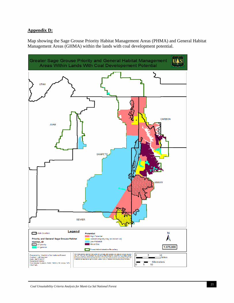
(i) There are active greater sage grouse leks and priority habitat within areas identified as
having coal development potential, see map located in Appendix D. There are standards
and guidelines in the Greater Sage Grouse ROD that are applicable to identified lands
with coal development potential, located in Appendix E. These standards and guidelines
will be evaluated as part of the site-specific analysis.
(ii) Big game key and general winter ranges have been delineated for the Manti-La Sal
National Forest. State data was used in delineating this layer. Some of these important
seasonal habitats are within areas identified as having coal development potential. The
UDWR has delineated their own deer and elk habitat layers that are very similar but
differ slightly in terminology and acres. Maps of the Forest winter ranges and UDWR
winter ranges can be found in Appendices F and G.
(iii) While species are known to seasonally migrate through the Forest, there are mapped
migration corridors within the Forest boundary. This criterion is most appropriately
applied to proposed leasing and mining areas based on site-specific analyses.
(iv) There are no identified areas on the Forest, within lands identified as having coal
development potential, that are at the extreme range for known plant species. Species for
which the entire known range exists within the Forest boundary, and which occur within
lands identified as having coal development potential are addressed under criterions 9 and
10.
Criterion Number 16
Federal lands in riverine, coastal and special floodplains (100-year recurrence interval) on which
the surface management agency determines that mining could not be undertaken without
substantial threat of loss of life or property shall be considered unsuitable for all or certain
stipulated methods of coal mining.

13
Coal Unsuitability Criteria Analysis for Manti-La Sal National Forest
Exemptions. This criterion does not apply to lands: To which the operator made substantial
legal and financial commitments prior to January 4, 1977; on which surface coal mining
operations were being conducted on August 3, 1977; or which include operations on which a
permit has been issued.
Analysis – Areas of the Forest identified as having coal development potential include riverine
floodplains. However,. Stipulated methods of underground mining are not expected to change
watershed characteristics sufficiently to alter flood threats or risk, therefore for the purposes of
land management planning, none have been determined to pose a substantial threat for loss of
life or property. Thus, no lands within the coal development potential area are found to be
unsuitable. The exemption to this criterion would apply, if identified and the underground
mining exemption (43 CFR §3461.1) would also apply.
Criterion Number 17
Federal lands which have been committed by the surface management agency to use as
municipal watersheds shall be considered unsuitable.
Exception. A lease may be issued where the surface management agency in consultation with
the municipality (incorporated entity) or the responsible governmental unit determines, as a
result of studies, that all or certain stipulated methods of coal mining will not adversely affect the
watershed to any significant degree.
Analysis – According to the FSH (2542.05) a Municipal Supply Watershed is a watershed that
serves a public water system as defined in the Safe Drinking Water of 1974, as amended (42
U.S.C. 300f-300j). According to the Safe Drinking water act the term ‘public water system’
means a system for the provision to the public of water for human consumption through pipes or
other constructed conveyances, if such a system has at least fifteen service connections or
regularly serves at least twenty-five individuals. Based on the Utah Department of Water Quality
GIS data (1 Aug 2017 (https://enviro.deq.utah.gov/), there are 74 public water systems on the
North Zone in nine HUC 5 level watersheds. These watersheds are Chicken Creek, Cottonwood
Creek, Ferron Creek, Huntington Creek, Lower San Pitch River, Middle San Pitch River,
Scofield Reservoir, Twelvemile Creek and West Creek (Appendix H). The systems provide
drinking water to the towns of Levan, Ephraim City, Manti City, Spring City, Wales, Mayfield,
Sterling, the Fillmore subdivision in Joes Valley, Fairview Lakes development and Trail Canyon
residents Association. Several campgrounds are served as well: Joes Valley, Indian Creek,
Ferron Reservoir, Forks of Huntington, Camp Shinob, Stuart visitor center, Old Folks Flat
campground, Flat Canyon Campground, MIA Shalom Recreation Camp, Manti Community
Campground, Lake Hill Campground, Mammoth Guard Station- Gooseberry Campground,
Twelve Mile Flat Campground and Old Pinery Recreation Area. Five of the 74 Public water
systems are located within areas the BLM identified as having High Coal Potential (Appendix
H). They occur in Huntington Creek and Scofield Reservoir HUC 5 level watersheds. 39 public
water supply locations occur in low coal potential zones. Therefore, the exception to this
criterion would apply. For the purposes of land management planning, the lands are not found to
be unsuitable, however the criterion would be reassessed if/when specific lease applications are
reviewed. The underground mining exemption (43 CFR §3461.1) would also apply.

14
Coal Unsuitability Criteria Analysis for Manti-La Sal National Forest
Criterion Number 18
Federal lands with National Resource Waters, as identified by states in their water quality
management plans, and a buffer zone of Federal lands ¼ mile from the outer edge of the far
banks of the water, shall be unsuitable.
Exception. The buffer zone may be eliminated or reduced in size where the surface management
agency determines that it is not necessary to protect National Resource Waters.
Analysis - The State of Utah has categorized all surface waters geographically located within the
boundaries National Forests into 3 categories according to whether point source discharge of
waste water is not permitted (category 1), point source discharge may be permitted provided that
the discharge does not degrade existing water quality (category 2), or category 3 where point
source discharges are allowed and degradation may occur
(https://rules.utah.gov/publicat/code/r317/r317-002.htm). Most surface waters with the MLNF
are classified as category 1. Category 2 surface waters are Electric Lake, the lower 4800 feet of
Deer Creek, both in the Huntington HUC 5 watershed on the Wasatch Plateau, and Chicken
Creek with its tributaries and Pigeon Creek with its tributaries both in the Chicken Creek HUC 5
Watershed on the Gunnison Plateau (Appendix I). Most waters in zones with coal development
potential are associated with Category 1 waters which do not allow point discharge of waste
waters even after treatment.
For the purposes of land management planning, the lands are not found to be unsuitable in the
coal development potential area. The underground mining exemptions (43CFR §3461.1) and
exemption for surface operations and impacts that are incident to an underground coal mine
[(surface Mining Control and Reclamation Act. Section 522 (e) (2) (A))] would apply. Relative
to the surface effects of underground mining this criterion would need to be analyzed on the site
specific basis for proposed lease actions to determine suitability and therefore the exception to
this criterion would apply.
Criterion Number 19
Federal lands identified by the surface management agency, in consultation with the state in
which they are located, as alluvial valley floors according to the definition in §3400.0-5(a) of this
title, the standards in 30 CFR Part 822, the final alluvial valley floor guidelines or the Office of
Surface Mining Reclamation and Enforcement when published, and approved state programs
under the Surface Mining Control and Reclamation Act of 1977, where mining would interrupt,
discontinue, or preclude farming, shall be considered unsuitable. Additionally, when mining
Federal land outside an alluvial valley floor would materially damage the quantity or quality of
water in surface or underground water systems that would supply alluvial valley floors, the land
shall be considered unsuitable.

15
Coal Unsuitability Criteria Analysis for Manti-La Sal National Forest
Exemptions. This criterion does not apply to surface coal mining operations which produced
coal in commercial quantities in the year preceding August 3, 1977, or which had obtained a
permit to conduct surface coal mining operations.
Analysis – No areas identified as having coal development potential on the Forest have been
designated or identified as Alluvial Valley Floors according to the definition in §3400.0-5(a) of
this title, the standards in 30 CFR Part 822, the final alluvial valley floor guidelines, or by the
Office of Surface Mining Reclamation and Enforcement. For the purposes of land management
planning, no lands within the coal development potential area were found unsuitable.
Criterion Number 20
Federal lands in a state to which is applicable a criterion (i) proposed by the state or Indian tribe
located in the planning area, and (ii) adopted by rulemaking by the Secretary, shall be considered
unsuitable.
Exceptions. A lease may be issued when:
(i) Such criterion is adopted by the Secretary less than 6 months prior to the publication of
the draft comprehensive land use plan or land use analysis plan, or supplement to a
comprehensive land use plan, for the area in which such land is included, or
(ii) After consultation with the state or affected Indian tribe, the surface management
agency determines that all or certain stipulated methods of coal mining will not adversely affect
the value which the criterion would protect.
Analysis – The State of Utah under State rule, R645-103-300, Utah Criteria for Designating
Areas as Unsuitable for Coal Mining and Reclamation Operations, has developed unsuitability
criteria, which are similar to Federal criteria. No Indian Tribes have proposed that any areas
identified as having coal development potential on the Forest be designated as unsuitable for coal
leasing/development. For the purposes of land management planning, the lands are not found to
unsuitable in the coal development potential area.

16
Coal Unsuitability Criteria Analysis for Manti-La Sal National Forest
Appendix A:

17
Coal Unsuitability Criteria Analysis for Manti-La Sal National Forest
Appendix B:
Utah Sensitive Species List for 6-counties located within the North Zone of the Manti-La Sal
National Forest. This is extracted from the full county list (as of April 10, 2017).
Utah’s State Listed Species by County *
*This list is a condensed excerpt from the State's individual county lists
Disclaimer: This list was compiled using known species occurrences and species observations
from the Utah Natural Heritage Program’s Biodiversity Tracking and Conservation System
(BIOTICS); other species of special concern likely occur in Utah Counties. This list includes
both current and historic records. (Last updated on October 1, 2015). Common Name
Scientific Name
State
Status Counties
American Three-toed
Woodpecker*
Picoides dorsalis SPC
J, Sa, Se, U
American White Pelican Pelecanus
erythrorhynchos
SPC
J, Se, U
Bald Eagle Haliaeetus leucocephalus SPC C, E, J, Sa, Se, U
Big Free-tailed Bat Nyctinomops macrotis SPC Se
Black Swift Cypseloides niger SPC Se, U
Black-footed Ferret Mustela nigripes S-ESA C, E
Bluehead Sucker Catostomus discobolus CS C, E, Sa, U
Bobolink* Dolichonyx oryzivorus SPC U
Bonneville Cutthroat Trout Oncorhynchus clarkii utah CS C, J, Sa, Se, U
Bonytail Gila elegans S-ESA C, E
Brown (Grizzly) Bear* Ursus arctos S-ESA Sa, Se, U
Burrowing Owl Athene cunicularia SPC C, E, J, Sa, Se
California Floater Anodonta californiensis SPC J, U
Canada Lynx Lynx canadensis S-ESA E, Sa, Se
Carinate Glenwood Pyrg Pyrgulopsis inopinata SPC Se
Colorado Pikeminnow Ptychocheilus lucius S-ESA C, E
Colorado River Cutthroat Trout Oncorhynchus clarkii
pleuriticus
CS
C, E, Sa, Se, U
Columbia Spotted Frog Rana luteiventris CS J, Sa, U
Dark Kangaroo Mouse * Microdipodops
megacephalus
SPC
J
Eureka Mountainsnail Oreohelix eurekensis SPC J, U
Ferruginous Hawk Buteo regalis SPC C, E, J, Sa, Se, U
Flannelmouth Sucker Catostomus latipinnis CS C, E
Fringed Myotis Myotis thysanodes SPC J, Se, U
Grasshopper Sparrow * Ammodramus
savannarum
SPC
J, Sa
Great Plains Toad Bufo cognatus SPC C, E
Greater Sage-grouse Centrocercus
urophasianus
SPC
C, E, J, Sa, Se, U
Humpback Chub Gila cypha S-ESA C, E
June Sucker Chasmistes liorus S-ESA U
Kit Fox Vulpes macrotis SPC C, E, J, Sa, Se, U

18
Coal Unsuitability Criteria Analysis for Manti-La Sal National Forest
Least Chub Iotichthys phlegethontis CS J, U
Lewis's Woodpecker Melanerpes lewis SPC J, Sa, U
Long-billed Curlew * Numenius americanus SPC J, Sa, Se, U
Ninemile Pyrg Pyrgulopsis nonaria SPC Sa
Northern Goshawk Accipiter gentilis CS C, E, J, Sa, Se, U
Otter Creek Pyrg Pyrgulopsis fusca SPC Se
Pygmy Rabbit Brachylagus idahoensis SPC J, Se
Razorback Sucker Xyrauchen texanus S-ESA C, E
Roundtail Chub Gila robusta CS C, E, U
Short-eared Owl* Asio flammeus SPC J, Se, U
Smooth Glenwood Pyrg Pyrgulopsis chamberlini SPC Se
Smooth Grassnake* Opheodrys vernalis SPC U
Southern Bonneville Springsnail Pyrgulopsis transversa SPC Sa, U
Southern Leatherside Chub Lepidomeda aliciae SPC J, Sa, Se, U
Spotted Bat* Euderma maculatum SPC U
Townsend's Big-eared Bat * Corynorhinus townsendii SPC C, E, J, Sa, Se, U
Utah Physa* Physella utahensis SPC J, U
Utah Prairie-dog Cynomys parvidens S-ESA Sa, Se
Western Red Bat * Lasiurus blossevillii SPC C, U
Western Toad Bufo boreas SPC C, E, J, Sa, Se, U
White-tailed Prairie-dog Cynomys leucurus SPC C, E, U
Yellow-billed Cuckoo Coccyzus americanus S-ESA U
*These species are not included on the 2015 UT WAP.
C – Carbon County, E – Emery County, J – Juab County, Sa – Sanpete County, Se – Sevier County, U –
Utah County

19
Coal Unsuitability Criteria Analysis for Manti-La Sal National Forest
Appendix C:
Utah’s 2015 Wildlife Action Plan (WAP) species of greatest conservation need (SGCN). This
list includes the 6-counties located within the North Zone of the Manti-La Sal National Forest.
This is extracted from the full county list (as of April 10, 2017).
Common Name Scientific Name ESA Status Counties
American Pika* Ochotona princeps Sa, Se, U
American White Pelican Pelecanus erythrorhynchos J, Se, U
Bald Eagle Haliaeetus leucocephalus C, E, J, Sa, U
Band-tailed Pigeon* Patagioenas fasciata U
Big Free-tailed Bat Nyctinomops macrotis Se
Black Rosy-finch* Leucosticte atrata E
Black Swift Cypseloides niger U
Black-footed Ferret Mustela nigripes Endangered E
Bluehead Sucker Catostomus discobolus C, E, Sa
Bonneville Cutthroat Trout Oncorhynchus clarkii utah C, J, Sa, Se, U
Bonytail Gila elegans Endangered C, E
Burrowing Owl Athene cunicularia C, E, J, Sa, Se, U
California Floater Anodonta californiensis J
Canada Lynx Lynx canadensis Threatened E, Se
Carinate Glenwood Pyrg Pyrgulopsis inopinata Se
Caspian Tern* Sterna caspia U
Colorado Pikeminnow Ptychocheilus lucius Endangered C, E
Colorado River Cutthroat
Trout Oncorhynchus clarkii pleuriticus C, E, Sa, Se, U
Columbia Spotted Frog Rana luteiventris J, Sa, U
Eureka Mountainsnail Oreohelix eurekensis J, U
Ferruginous Hawk Buteo regalis C, E, J, Sa, U
Flammulated Owl* Otus flammeolus C, J
Flannelmouth Sucker Catostomus latipinnis C, E
Fringed Myotis Myotis thysanodes J
Golden Eagle* Aquila chrysaetos C, E, J, Sa, Se, U
Great Plains Toad Bufo cognatus E
Greater Sage-grouse Centrocercus urophasianus Candidate C, E, J, Sa, Se, U
Green River Pebblesnail* Fluminicola coloradoensis U
Humpback Chub Gila cypha Endangered C, E
June Sucker Chasmistes liorus Endangered U
Kit Fox Vulpes macrotis E, J
Least Chub Iotichthys phlegethontis Candidate J
Lewis's Woodpecker Melanerpes lewis J, Sa, Se, U
Little Brown Myotis Myotis lucifugus U
Ninemile Pyrg Pyrgulopsis nonaria Sa
Northern Leopard Frog Rana pipiens C, E, J, Sa, Se, U
Otter Creek Pyrg Pyrgulopsis fusca Se

20
Coal Unsuitability Criteria Analysis for Manti-La Sal National Forest
Peregrine Falcon* Falco peregrinus C, E, J, Sa, Se, U
Pygmy Rabbit Brachylagus idahoensis Se
Razorback Sucker Xyrauchen texanus Endangered C, E
Roundtail Chub Gila robusta C, E
Smith's Black-headed Snake* Tantilla hobartsmithi C
Smooth Glenwood Pyrg Pyrgulopsis chamberlini Se
Snowy Plover* Charadrius nivosus J, U
Southern Bonneville
Springsnail Pyrgulopsis transversa Sa, U
Southern Leatherside Chub Lepidomeda aliciae J, Sa, Se, U
Utah Prairie-dog Cynomys parvidens Se
Western Toad Bufo boreas E, Se, U
White-tailed Prairie-dog Cynomys leucurus C, E
Wolverine* Gulo gulo Sa
Yellow-billed Cuckoo Coccyzus americanus Candidate E, J, U
*These species are not included in the UT Sensitive Species list (as of April 10, 2017).
C – Carbon County, E – Emery County, J – Juab County, Sa – Sanpete County, Se – Sevier
County, U – Utah County
21
Coal Unsuitability Criteria Analysis for Manti-La Sal National Forest
Appendix D:
Map showing the Sage Grouse Priority Habitat Management Areas (PHMA) and General Habitat
Management Areas (GHMA) within the lands with coal development potential.

22
Coal Unsuitability Criteria Analysis for Manti-La Sal National Forest
Appendix E:
Applicable standards and guidelines from the US Forest Service 2015 Greater Sage Grouse
Record of Decision (ROD).
GRSG-GEN-ST-006-Standard – Do not authorize new surface disturbing and disruptive
activities that create noise at 10dB above ambient measured at the perimeter of an occupied lek
during lekking (from March 1 to April 30) from 6 p.m. to 9 a.m. Do not include noise resulting
from human activities that have been authorized and initiated within the past 10 years in the
ambient baseline measurement.
GRSG-GEN-GL-009-Guideline – Development of tall structures within 2 miles from the
perimeter of occupied leks, as determined by local conditions (e.g., vegetation or topography),
with the potential to disrupt breeding or nesting by creating new perching/nesting opportunities
for avian predators or by decreasing the use of an area, should be restricted within nesting
habitat.
Coal Mines – Unleased
GRSG-M-CMUL-ST-091-Standard – When consenting to new underground coal leases, include
a lease stipulation prohibiting the location of surface facilities in priority habitat management
areas, sagebrush focal areas, and Anthro Mountain.
Coal Mines – Leased
GRSG-M-CML-ST-092-Standard – In priority habitat management areas, sagebrush focal areas,
and Anthro Mountain, do not authorize new appurtenant surface facilities related to existing
underground mines unless no technically feasible alternative exists. If new appurtenant surface
facilities associated with existing mine leases cannot be located outside of priority habitat
management areas and sagebrush focal areas, locate them within any existing disturbed areas, if
possible. If location within an existing disturbed area is not possible, then construct new facilities
to minimize disturbed areas while meeting mine safety standards and requirements as identified
by the Mine Safety and Health Administration mine-plan approval process and locate the
facilities in an area least harmful to greater sage-grouse habitat based on vegetation, topography,
or other habitat features.

23
Coal Unsuitability Criteria Analysis for Manti-La Sal National Forest
Appendix F:
Manti-La Sal National Forest big game (elk and mule deer) key and general winter ranges within
lands with coal development potential.

24
Coal Unsuitability Criteria Analysis for Manti-La Sal National Forest
Appendix G:
UDNR Utah Department of Wildlife Resources (UDWR) winter ranges within lands with coal
development potential with Elk and Mule deer habitat layers included from the UDWR GIS
database (accessed April 12, 2017).

25
Coal Unsuitability Criteria Analysis for Manti-La Sal National Forest
Appendix H:
Five of the 74 Public water systems are located within areas the BLM identified as having High
Coal Potential

26
Coal Unsuitability Criteria Analysis for Manti-La Sal National Forest
Appendix I:

27
Coal Unsuitability Criteria Analysis for Manti-La Sal National Forest
Recommended