37
CHAPTER 3
ENVIRONMENTAL SETTINGS
3.1 Introduction
Groundwater occurrence, being subsurface phenomenon, its identification and location is
based on indirect analysis of some directly observable terrain features like lithology,
geological structures, geomorphic features and their hydrologic characters. Its movement
is determined by complex combination of various natural and anthropogenic factors.
Usage of water mainly depends upon population, agricultural practices, industrial setup
and socioeconomic conditions of the people of the area. In order to assess and evaluate
the water resources in a holistic manner, it is essential to consider all these parametres. A
brief overview of the various factors that are closely related to movement, recharge and
discharge of groundwater of the study area are discussed in the following sections.
3.2 Study area
The Yamuna Nagar district (Fig.3.1) is located in the North eastern part of Haryana state
and is extended between 29055′ to 30
0 31′N Latitude and 77
0 04′ to 77
0 53′E Longitude.
The total geographical area of the district is approximately 1723 km2 that constitutes
about 4% of the total geographical area of the state. The district was carved out in 1989
out of Ambala and Kuruksehtra districts of the state.
It is surrounded by Himachal Pradesh in North and shares its boundary with
district Ambala in West. District Karnal and Kurukshetra lie in its South and South West
respectively. It is bounded by the state of Uttar Pradesh in its North East to South East.
Administratively the district is divided into two sub-divisions (Jagadhari and Bilaspur),
three tehsils (Jagadhari, Chhachhrauli and Bilaspur), three sub tehsils (Radaur, Sadhaura
and Mustfabad) and six development blocks (Bilaspur, Chhachhrauli, Jagadhri,
Mustfabad, Radaur and Sadhaura). There are total 639 villages out of which only 613 are

38
Fig. 3.1: Location map of district Yamuna Nagar

39
inhabited. The district had a population of 12, 14,162 which was nearly 4.8% of total
population of the state (Census of India, 2011).
3.3 Physiography
The district has three distinct physiographic units; hilly terrain, piedmont plain and
alluvial plain. Siwalik Hill range occupies the northern border of the district with
Himachal Pradesh and attains the height up to 683 m above mean sea level (amsl). The
hills are about 400 m high with respect to the adjacent alluvial plains. These are
characterized by the broad tableland topography that has been carved into quite sharp
slopes by numerous ephemeral streams that come down to the outer slopes of the
Siwaliks and spread much of gravels, boulders, pebbles in the beds of these streams.
Mostly it is covered with reserve forests. A dissected rolling plain (locally known as
Kandi belt) in the northern parts of district is a transitional tract between Siwalik Hills
and alluvial plains with elevation varying between 300 and 360 m (amsl). About 1385
km2 of the district is covered by alluvial plains which form a part of Indo-Gangetic plain.
These are level or gently undulating plains. The general elevation in plains varies
between 254- 310 m above mean sea level.
3.4 Drainage
The district is mainly drained by the rivers Yamuna and Markanda and their tributaries.
The dominant drainage pattern observed in the district is dendritic to sub-dendritic.
Markanda is tributary of river Ghaggar and drains major part of the district. The high land
between Markanda River and small rivulets of River Yamuna acts as basin boundary
between west flowing rivers of Indus system and east flowing rivers of Ganga basin.
River Yamuna after rising from snow clad peaks of the middle Himalayas at Yamunotri,
enters the district from its North-eastern corner through a narrow corridor in the Siwaliks.
The perennial river drains through eastern part of the district and acts as boundary
between Haryana and Uttar Pradesh state. The important rivers/ streams prevailing in the
district are Yamuna, Chautang, Rakshi, Som, Boli, Pathrala, and Sarasvati. The Boli
40
stream and Pathrala nadi join near village Hafizpur and then joins Som nadi near
Dadupur. The combined Som and Pathrala then join river Yamuna near village Mehar
Majra. Excessive rainfall results in overflow of these rivers causing extensive damage to
standing crops and heavy losses to life and property. The Western Yamuna Canal (WYC)
with limited drainage network in Chhachhrauli block passes through Chhachhrauli,
Jagadhri and Radaur blocks of the district. Augmentation canal is carved out from WYC
at Hamida Head in Yamuna Nagar and passes through Yamuna Nagar and Radaur blocks.
Length of different canals, minors, distributaries and river Yamuna is listed in Table 3.1.
The drainage and canal network is shown in Fig. 3.2.
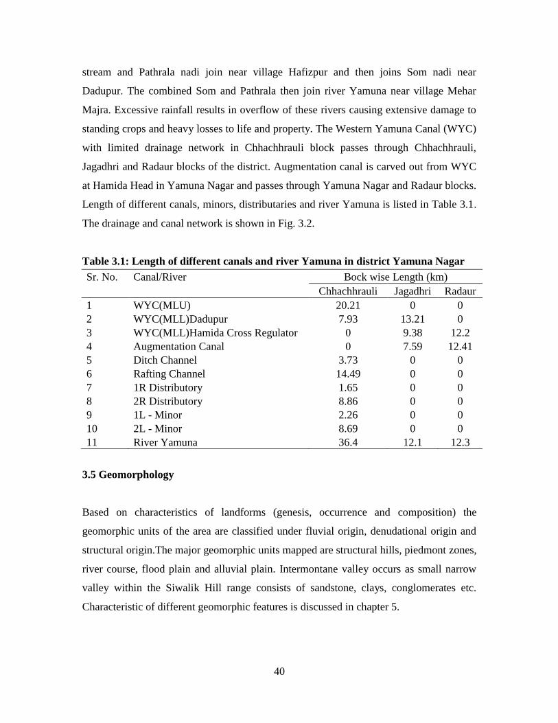
Table 3.1: Length of different canals and river Yamuna in district Yamuna Nagar
Sr. No. Canal/River Bock wise Length (km)
Chhachhrauli Jagadhri Radaur
1 WYC(MLU) 20.21 0 0
2 WYC(MLL)Dadupur 7.93 13.21 0
3 WYC(MLL)Hamida Cross Regulator 0 9.38 12.2
4 Augmentation Canal 0 7.59 12.41
5 Ditch Channel 3.73 0 0
6 Rafting Channel 14.49 0 0
7 1R Distributory 1.65 0 0
8 2R Distributory 8.86 0 0
9 1L - Minor 2.26 0 0
10 2L - Minor 8.69 0 0
11 River Yamuna 36.4 12.1 12.3
3.5 Geomorphology
Based on characteristics of landforms (genesis, occurrence and composition) the
geomorphic units of the area are classified under fluvial origin, denudational origin and
structural origin.The major geomorphic units mapped are structural hills, piedmont zones,
river course, flood plain and alluvial plain. Intermontane valley occurs as small narrow
valley within the Siwalik Hill range consists of sandstone, clays, conglomerates etc.
Characteristic of different geomorphic features is discussed in chapter 5.

41
Fig. 3.2: Natural drainage and canal network in district Yamuna Nagar

42
3.6 Geology
The geological milieu in the district represents the lithological formation belonging to the
Indo-Gangetic plain in south and Extra-Peninsular regions in north ranging in age from
Upper Miocene to recent. The northern part of the district is covered by middle and upper
Siwalik rocks of late Miocene to early Pleistocene age whereas the southern part exposes
the Quarternary sediments of middle Pleistocene to Holocene age. Various lithological
units mapped in the study area are Ambala (older) alluvium, Fan alluvium, Channel
alluvium, Terrace (younger) alluvium, Middle and Upper Siwaliks described in chapter 5.
3.7 Hydrogeology
Yamuna Nagar district forms a part of Upper Yamuna river basin. The groundwater
exploration carried out by Central Groundwater Board in the district reveals that clay
group of formations dominates over the sand group in the district area. Ground-
water in the district occurs in the alluvium under confined to semi-confined conditions
and follows the land slope of the area (Angurala et al., 2007). These aquifers consist of
sand, silt, gravels and kankar associated with clay and form highly potential aquifers.
Permeable granular zones occurring in alluvium comprise of fine to medium grained sand
and occasionally coarse sand and gravel having extensive lateral as well as vertical
extent. The Kandi belt, which lies in the foothills of Siwalik Hills and consisting of
boulders, cobbles and pebbles, constitutes the major aquifer horizon. This region has not
been fully explored. Shallow aquifers embedded in clay beds occur as isolated lenses,
whereas aquifers in alluvial areas occur on regional scale and are quite extensive. These
aquifers generally consist of sands (fine to coarse grained) and gravels and are often
intercepted by clay and kankar horizons. The principal source of groundwater recharge in
the district is through rainfall however return recharge from irrigation, seepage from
canal and water conservation structures also contribute to groundwater.
43
3.8 Soils
The soils of the district are non-calcareous, non saline and non-alkaline in general. Soils
in the undulated tract are sandy loam whereas in the plains of Yamuna, the soils are
sandy loam on surface loam to clay loam at depths, highly permeable and have low to
medium productivity. Except in two-three patches the soils in general are moderately to
excessively drained.
3.9 Climate and Rainfall
The district has a sub-tropical continental monsoon climate where we find seasonal
rhythm, hot summer, cool winter, unreliable rainfall and great variation in temperature.
Temperature begins to rise from March to June. May and June are the hottest months
while December and January are the coldest. The maximum temperature recorded during
summers is 490 C and it is as low as 4
0C in winters. With the onset of monsoon,
temperature starts falling and during monsoon period weather remains uncomfortable due
to increased humidity and warm nights. Relative humidity during monsoon varies
between 75 and 85 percent and it is as low as 20 percent during summers. Rainy season
commences from mid of June and lasts upto September. Atmosphere is generally dry
during rest of the year. The transition from summer to winter takes place through months
of October and November. The winter season starts from the mid of November and lasts
till mid of March. Dense fog occurs during December and January. The climate of the
district is suitable for growing rice, wheat and sugarcane which are the major crops of the
district. The district receives rainfall from southwest monsoon season which commences
late in the month of June and continues upto September. Rainfall is recorded by 10
rainfall gauges located in six different blocks of the district and is monitored by Block
Development Office of each block and Irrigation Department of the district. The average
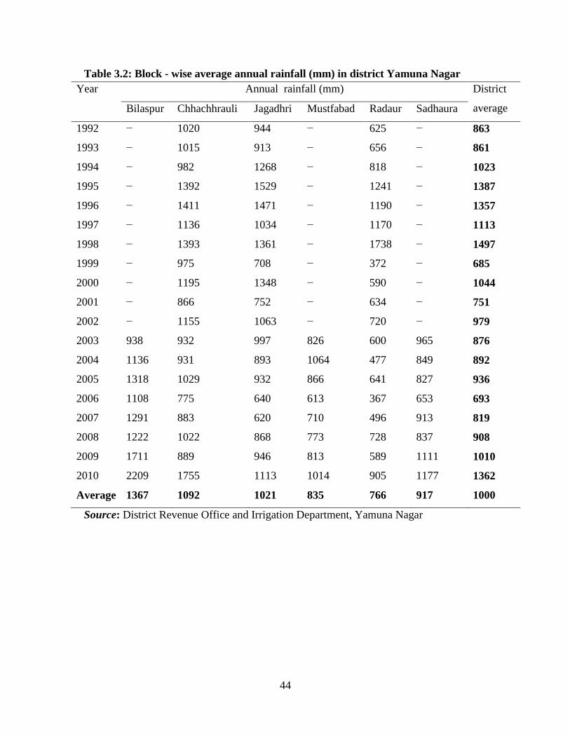
annual rainfall of the district is approximately 1000 mm (Table 3.2). Nearly 82% of the
total annual rainfall occurs during the months from June to September. July and August
are the wettest months. Rest 18% rainfall is received during non-monsoon period in the
44
Table 3.2: Block - wise average annual rainfall (mm) in district Yamuna Nagar
Year Annual rainfall (mm) District
average
Bilaspur Chhachhrauli Jagadhri Mustfabad Radaur Sadhaura
1992 − 1020 944 − 625 − 863
1993 − 1015 913 − 656 − 861
1994 − 982 1268 − 818 − 1023
1995 − 1392 1529 − 1241 − 1387
1996 − 1411 1471 − 1190 − 1357
1997 − 1136 1034 − 1170 − 1113
1998 − 1393 1361 − 1738 − 1497
1999 − 975 708 − 372 − 685
2000 − 1195 1348 − 590 − 1044
2001 − 866 752 − 634 − 751
2002 − 1155 1063 − 720 − 979
2003 938 932 997 826 600 965 876
2004 1136 931 893 1064 477 849 892
2005 1318 1029 932 866 641 827 936
2006 1108 775 640 613 367 653 693
2007 1291 883 620 710 496 913 819
2008 1222 1022 868 773 728 837 908
2009 1711 889 946 813 589 1111 1010
2010 2209 1755 1113 1014 905 1177 1362
Average 1367 1092 1021 835 766 917 1000
Source: District Revenue Office and Irrigation Department, Yamuna Nagar

45
Fig. 3.3: Average monthly rainfall at various stations in district Yamuna Nagar
0
50
100
150
200
250
300
350
400
450
Rain
fall
(mm
)
Tajewala
Dadupur
Yamuna Nagar
Radaur Canal RH
Jagadhri
Chhachhrauli
Bilaspur
Sadhaura
Mustfabad
Radaur
Distt. Average
46
wake of western disturbances and thunderstorms. The average monthly rainfall recorded
at different gauge stations is shown in Fig. 3.3.
3.10 Agriculture
The district is primarily agrarian as land is highly suitable for agricultural purposes.
Therefore intensive agriculture is being practiced in the district. Nearly 80% of the total
geographical area is under cultivation. Rice and Sugarcane are the main Kharif crops
whereas Wheat is dominant in Rabi season. Maize and Bajra are the other crops which
are grown in very small fractions. Pulses like Grams and Moong along with some
oilseeds are also grown in small parts of the district. More than85% of the area is double
cropped (Table 3.3). Saathi or summer paddy a short term crop was also prevalent in the
district. It was used to be sown in the month of April/ May and harvested in the month of
July. The water requirement of “Saathi” during the period April to June is very high due
to high evapotranspiration rate and low rainfall during this period. This puts additional
stress on groundwater during summer. As a result the Government of Haryana has
banned growing of this crop by enacting “The Haryana Preservation of Sub-Soil Water
Act, 2009”.
3.11 Irrigation
The groundwater is major sources of irrigation in the district and only small area of 4000
ha is being irrigated by canal network in Chhachhrauli block. About 99% of the gross
cropped area was irrigated by tubewells and canal network in year 2008-09 (Table 3.4).
8,823 diesel tubewells and 16,763 electric pumping sets in the district were in operation
to irrigate on one lakh hectares of cropped area in1998-99 (DCHB, 2001). The number of
tubewells has gone up to 27891 in the year 2008-009 (Table 3.5). The crops grown,
particularly the paddy and sugarcane, in the district are water intensive, therefore the
demand of water for irrigation has been tremendous.Tubewell density in the district has
increased from 13.56 tubewells/km2 in 1990-91 to17.97 tubewells/km
2 in 2009-10. Diesel
sets which are used for shallow water table are now replaced by electricity controlled

47
Table 3.3: Block-wise cropped area (ha) in district Yamuna Nagar during 2005-06 −2009-10
Year 2005-06 2006-07 2007-08 2008-09 2009-10 Average
Block/Season Kharif Rabi Kharif Rabi Kharif Rabi Kharif Rabi Kharif Rabi Kharif Rabi Total
Bilaspur 19984 15948 19924 17149 20181 16839 18479 18964 21367 18485 19987 17477 37464
Chhachhrauli 26783 22474 27015 24239 26803 23985 25226 25763 24007 26196 25967 24531 50498
Jagadhri 18642 13537 18566 14590 18620 14910 19099 18005 17988 18375 18583 15884 34467
Mustfabad 16839 12833 16947 13644 16982 13472 19724 15853 19117 15966 17922 14354 32275
Radaur 19858 14349 19712 15194 19654 15140 20250 18205 19541 18421 19803 16262 36065
Sadhaura 8322 7121 8484 7798 8311 7707 8501 8705 8395 8616 8403 7989 16392
District 110427 86262 110648 92612 110550 92053 111280 105495 110415 106060 110664 96497 207161
Source: Deputy Director Agriculture, Department of Agriculture, Yamuna Nagar
Table 3.4: Block-wise irrigated area (ha) in district Yamuna Nagar during 2005-06 −2009-10
Year 2005-06 2006-07 2007-08 2008-09 2009-10 Average
Block/Season Kharif Rabi Kharif Rabi Kharif Rabi Kharif Rabi Kharif Rabi Kharif Rabi Total
Bilaspur 19584 15648 19524 16849 19781 16539 18179 18664 21067 18185 19627 17177 36804
Chhachhrauli 26183 22074 26415 23739 26303 23785 24726 25563 23607 25896 25447 24211 49658
Jagadhri 18642 13537 18566 14590 18620 14910 19099 18005 17988 18375 18583 15884 34467
Mustfabad 16839 12833 16947 13644 16982 13472 19724 15853 19117 15966 17922 14354 32275
Radaur 19858 14349 19712 15694 19654 15140 20250 18205 19541 18421 19803 16262 36065
Sadhaura 7822 6921 7984 7598 7911 7607 8101 8505 7895 8416 7943 7809 15752
District 108927 85362 109148 92112 109250 91453 110080 104795 109215 105260 109324 95697 205021
Source: Deputy Director Agriculture, Department of Agriculture, Yamuna Nagar

48
Table 3.5: Block wise number of tubewells in district Yamuna Nagar
Block No. of minor irrigation units
as on 31.03.2009
Density
(units /km2)
Diesel Sets Electric Sets Total
Bilaspur 540 2818 3358 10.23
Chhachhrauli 2732 3644 6376 12.42
Jagadhri 1558 3684 5242 16.76
Mustfabad 436 4167 4603 22.98
Radaur 1114 5078 6192 25.33
Sadhaura 750 1370 2120 13.53
District 7130 20761 27891 16.20
Source: District Statistical Abstract, 2010
Table 3.6: Diesel and electricity operated tubewells in district Yamuna Nagar
Tubewell sets 1990-91 1996-97 2009-10
Diesel Units 11075 9322 5313
Electric Units 12745 16838 26248
Total 23820 26160 31561
Source: Statistical Abstract of Haryana, 2011

49
tubewells (Table 3.6) to tap water from deeper depths due declining trend of the water
level below the surface.
3.12 Natural Vegetation
The forest area of the district Yamuna Nagar has a moderate to dense vegetation. Forests
are the sources that provide raw material for paper industry, saw mills and packing
industries in the district. The district covers Jagadhri, Kalsia, Chuharpur, Kalesar and
Sadhaura forest ranges. The total forest cover in the district was approximately 218 km2
in 2000-01(District Statistical Abstract, 2002). Shisham (Dalbergia sissoo), Kikar
(Acacia nilotica), Peepal (Ficus religiosa), Mango (Mangifera indica), Jamun (Syzygium
cumini), Neem (Azadirachta indica), Badh (Ficus bengalensis), Safeda (Eucalyptus
hybrid) etc. are the important tree species grown in the area. Tropical dry deciduous
forests and sub-tropical forests are found on the hilly tract. These forests contain a
number of hard wood species like Chhall, Khair and Jhingam. Growth is denser on
northern and north eastern slopes. Sal occurs on northern slopes of Siwalik Hills in
Kalesar tract. A large number of climbers and grasses are also seen. Species of Acacia
and Prosopis are also seen in the scrub lands and grazing lands.
3.13 Industrial Growth
Yamuna Nagar is an important industrial town of the state having metal utensil and
plywood industries. After Faridabad it is the second largest revenue generator of the state.
Large industries like Saraswati Sugar Mills, Shree Gopal Paper Mills and Bharat Starch
Industries were established in 1933, 1937 and 1938 respectively. Haryana Distillery
established in 1962 produces rectified and denatured spirit, country and Indian made
foreign liquor. It is observed that major industrial concentration is in the areas of wood
and wood products, paper and paper products, basic metal and alloys industries, metal
products and parts etc. Other smaller fields are chemical and chemical products, rubber,
plastic, electrical machinery, transport equipment parts etc. Shree Gopal Paper Mill,
Saraswati Sugar Mill, Haryana Distillery and Bharat Starch Industries are the main

50
industrial units that draw water from subsurface for their production. Flourishing of
plyboard industry during early eighties has put additional stress on groundwater.
Recommended


![FREE MIND IAS ACADEMY · FREE MIND IAS ACADEMY [ Contact No: 07553553697, 7725882422, 9131552951 ] 1. there are no east flowing river in kerala. 2. there are no west flowing rivers](https://img.dokumen.tips/doc/110x75/606b39dbd4c09c60b152f941/free-mind-ias-academy-free-mind-ias-academy-contact-no-07553553697-7725882422.jpg)