Campaign GPS processing
Fun with GAMIT, GLOBK, TRACK, and the Queen’s nose
Authors: Tom Herring, Robert King, Mike Floyd, Eric Lindsey, Katia Tymofyeyeva

Outline
� What are GAMIT, GLOBK, and TRACK? � What’s GPS? � Why campaign? � Occupy San Jacinto.

Let’s get this straight… � GAMIT – positions � GLOBK – repeatabilities, velocities, time
series � TRACK – kinematic GPS

Pseudorange
~ 20,200 km
T
T+t
Satellite-received
Receiver-generated
T T+t
t

Pseudorange
(ctsati–rec)2 = (xsati – xrec)2 + (ysati
– yrec)2 + (zsati – zrec)2
But…
t is travel time (as measured by clocks in the satellite and receiver), which is subject to error between these clocks.
So…
We need a minimum of four satellites in order to solve for an additional unknown, the clock bias.
R = � Rsat – Rrec �
R = c[(T+t) – T] = ct
R
x (0°E, 0°N)
y (90°E, 0°N)
z (0°E, 90°N)
RSAT
RREC
R
RREC

Your location is: 37o 23.323’ N
122o 02.162’ W
Pseudorange
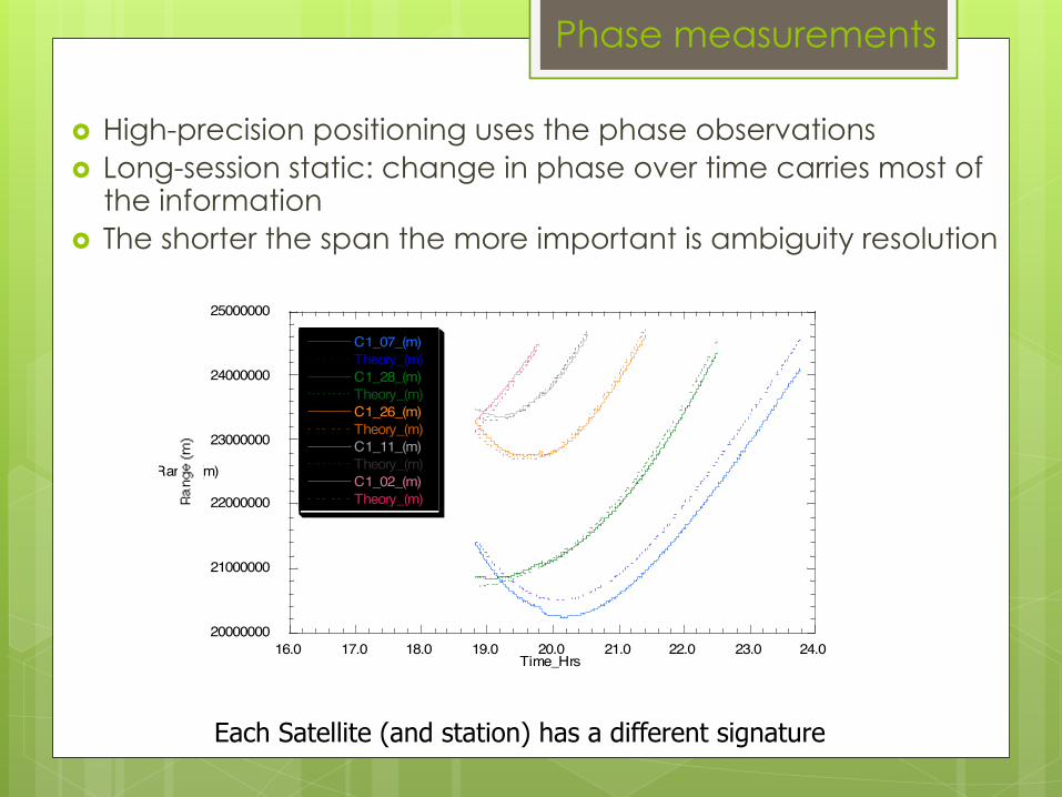
Phase measurements
� High-precision positioning uses the phase observations � Long-session static: change in phase over time carries most of
the information � The shorter the span the more important is ambiguity resolution
20000000
21000000
22000000
23000000
24000000
25000000
16.0 17.0 18.0 19.0 20.0 21.0 22.0 23.0 24.0
C1_07_(m)Theory_(m)C1_28_(m)Theory_(m)C1_26_(m)Theory_(m)C1_11_(m)Theory_(m)C1_02_(m)Theory_(m)
Range (m)
Time_Hrs
Each Satellite (and station) has a different signature

Limits of GPS Accuracy
� Signal propagation effects � Signal scattering ( antenna phase center / multipath ) � Atmospheric delay (mainly water vapor)
� Ionospheric effects � Receiver noise
� Unmodeled motions of the station
� Monument instability
� Loading of the crust by atmosphere, oceans, and surface water
� Unmodeled motions of the satellites
� Reference frame

Multipath is interference between the direct and a far-field reflected signal (geometric optics apply)
• Avoid Reflective Surfaces • Use a Ground Plane Antenna • Avoid near-ground mounts • Observe for many hours • Remove with average from many days
To mitigate the effects:
Multipath

Atmospheric delay
The signal from each GPS satellite is delayed by an amount dependent on the pressure and humidity and its elevation above the horizon. We invert the measurements to estimate the average delay at the zenith (green bar). ( Figure courtesy of COSMIC Program )

Multipath and Water Vapor Effects in the Observations
One-way (undifferenced) LC phase residuals projected onto the sky in 4-hr snapshots. Spatially repeatable noise is multipath; time-varying noise is water vapor. Red is satellite track. Yellow and green positive and negative residuals purely for visual effect. Red bar is scale (10 mm).
Signal propagation

Why campaign?
(it’s fun)

Continuous

“Special” Characteristics of Survey-mode Data
� Editing is critical: every point counts � Usually combined with cGPS data to provide
continuity and a tie to the ITRF � Appropriate relative weighting needed in combining
with cGPS data � Antenna meta-data may be more complicated � Heights may be problematic if different antennas
used � Seasonal errors behave differently than in cGPS data:
best strategy is to observe at the same time of the year (unlike cGPS, which has minimal seasonal sensitivity at 1.5, 2.5, 3.5 ….years total span)
� Multipath and atmosphere more of a problem for short occupations.
Campaign

Occupy San Jacinto

Where are we?

Where are we?

Where are we?

Log sheets

Rinex
The Rinex File � File name: [stid][DDD][#].[YY]o
� E.g., e5791100.14o
� For several occupations in one day,
change # from 0 to 1, etc.
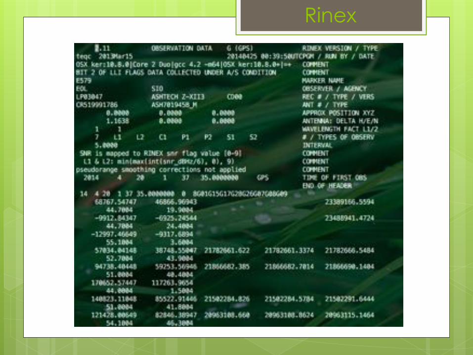
Rinex

Ingredients � Campaign rinex files � Log sheets � A few chosen continuous stations to
“anchor” the solution.

Recipe � Run sh_setup –yr YYYY � Set up processing in tables/
� process.defaults � sittbl. � sites.defaults � Update station.info
� Run gamit � Post-process with GLOBK

sh_setup � Run from top directory, containing folder
“rinex/” � Specify year sh_setup –yr 2012 � Creates “tables/” folder in the top (YEAR)
directory, and copies the tables that will be necessary for processing.
Recipe

Inside tables/ � Edit process.defaults
� Enter your mailto address if you want � Session info � dopts and copts
� Edit sittbl. � Pick one station (preferably a continuous
one) to constrain. � Check paths
Recipe

Inside tables/ � Edit sites.defaults
� Delete all non-commented lines � Enter: all_sites expt xstinfo � Enter the names of your continuous stations with
“expt ftprnx xstinfo”. � E.g., cact_gps hw78 ftprnx xstinfo � NOTE: Leading space!
� Edit sittbl. � Pick one station (preferably a continuous one)
to constrain. � E.g., P488 P488_GPS NNN 0.003 0.003 0.01
Recipe

Inside tables/ � Tell GAMIT which stations you are going to
process � sh_upd_stnfo -l sd; mv station.info.new
station.info � Continuous stations first
� sh_upd_stnfo -files ../rinex/*.Yyo � Then add campaign
Recipe

Ready to run! � sh_gamit -expt hw78 -d 2012 125 126 -
pres ELEV -orbit IGSF -c � Run gamit from the top directory � This runs gamit for experiment “hw78”, for
days 125 and 126 in the year 2012, with IGSF orbits and plots showing phase vs. elevation.
Recipe

Results. � Look at file [day]/q[expt]a.[day]
Recipe

Phase residual plots � Set with -pres elev in sh_gamit command line
(requires GMT) � Postscript files in day directory, by default
converted to gif in /gifs directory and then erased (needs ImageMagik convert program).
� Use to assess multipath, water vapor, and antenna phase center model
“Sky plot” Phase vs elevation angle
Results

Normal pattern: bands are high-frequency multipath; red is smoothing of individual values, showing no strong systematics. Mid-elevation angle noise could be atmospheric delay errors? Bad pattern: systematic signature of smoothed values indicates a poor model of the antenna phase pattern (perhaps a misidentified antenna in station.info) (Green lines show the elevation-dependent noise model shown at top and used to reweight the data in solve)
Results
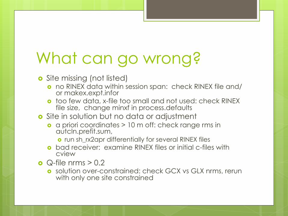
What can go wrong? � Site missing (not listed)
� no RINEX data within session span: check RINEX file and/or makex.expt.infor
� too few data, x-file too small and not used: check RINEX file size, change minxf in process.defaults
� Site in solution but no data or adjustment � a priori coordinates > 10 m off: check range rms in
autcln.prefit.sum, � run sh_rx2apr differentially for several RINEX files
� bad receiver: examine RINEX files or initial c-files with cview
� Q-file nrms > 0.2 � solution over-constrained: check GCX vs GLX nrms, rerun
with only one site constrained

Post-processing � GLOBK
� Velocities and time series
� GLRED � Repeatabilities
� GLORG � Fine-tuning and corrections
Recipe
Recommended