TR010018 HE/A14/EX/193
Comparison between draft Development Consent Order (Rev 5)
and draft Development Consent Order (Rev 4)
October 2015
The Infrastructure Planning (Examination Procedure) Rules 2010
A14Cambridge to Huntingdon
improvement schemeDevelopment Consent Order Application
193

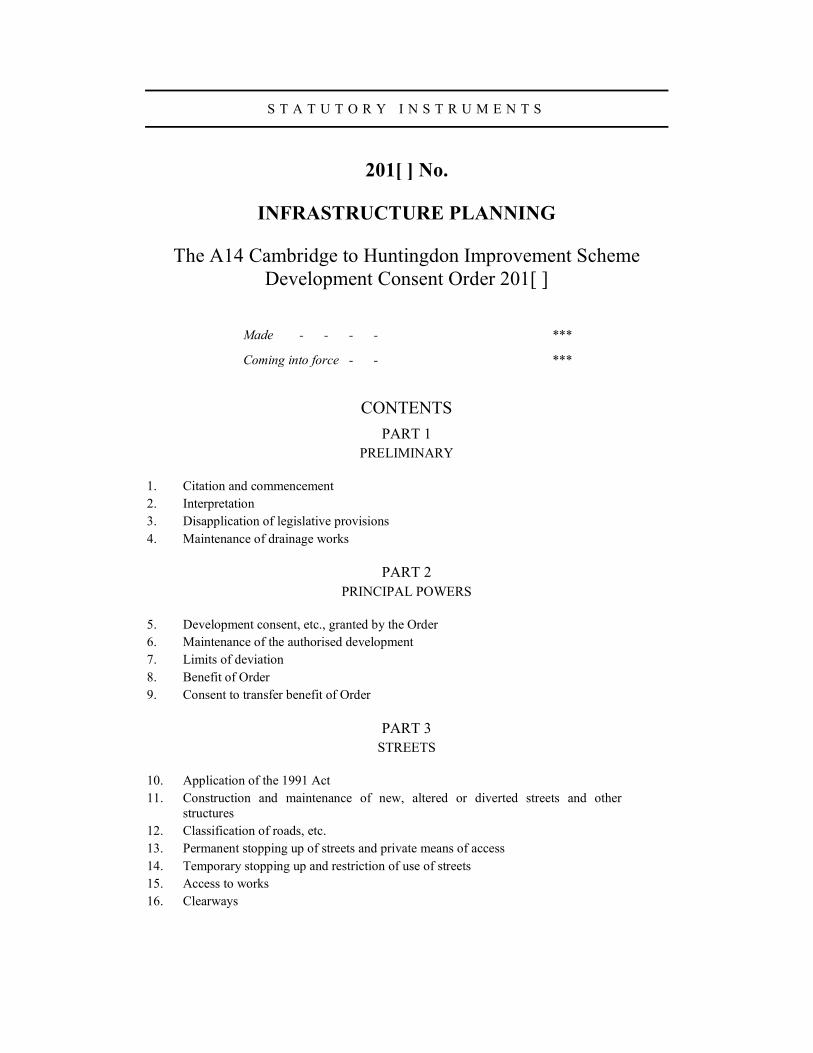
S T A T U T O R Y I N S T R U M E N T S
201[ ] No.
INFRASTRUCTURE PLANNING
The A14 Cambridge to Huntingdon Improvement Scheme
Development Consent Order 201[ ]
Made - - - - ***
Coming into force - - ***
CONTENTS
PART 1
PRELIMINARY
1. Citation and commencement
2. Interpretation
3. Disapplication of legislative provisions
4. Maintenance of drainage works
PART 2
PRINCIPAL POWERS
5. Development consent, etc., granted by the Order
6. Maintenance of the authorised development
7. Limits of deviation
8. Benefit of Order
9. Consent to transfer benefit of Order
PART 3
STREETS
10. Application of the 1991 Act
11. Construction and maintenance of new, altered or diverted streets and other
structures
12. Classification of roads, etc.
13. Permanent stopping up of streets and private means of access
14. Temporary stopping up and restriction of use of streets
15. Access to works
16. Clearways
2
PART 4
SUPPLEMENTAL POWERS
17. Discharge of water
18. Protective works to buildings
19. Authority to survey and investigate land
PART 5
POWERS OF ACQUISITION AND POSSESSION OF LAND
20. Compulsory acquisition of land
21. Compulsory acquisition of land – incorporation of the mineral code
22. Time limit for exercise of powers to possess land temporarily or to acquire land
compulsorily
23. Compulsory acquisition of rights
24. Public rights of way
25. Private rights over land
26. Application of the Compulsory Purchase (Vesting Declarations) Act 1981
27. Acquisition of subsoil or airspace only
28. Acquisition of part of certain properties
29. Rights under or over streets
30. Temporary use of land for carrying out the authorised development
31. Temporary use of land for maintaining the authorised development
32. Statutory undertakers
33. Apparatus and rights of statutory undertakers in stopped up streets
34. Recovery of costs of new connection
35. Special category land
PART 6
OPERATIONS
36. Felling or lopping of trees and removal of hedgerows
37. Trees subject to tree preservation orders
PART 7
MISCELLANEOUS AND GENERAL
38. Operational land for purposes of the 1990 Act
39. Defence to proceedings in respect of statutory nuisance
40. Protective provisions
41. Certification of plans, etc.
42. Service of notices
43. Arbitration
44. Appeals
45. Traffic regulation
3
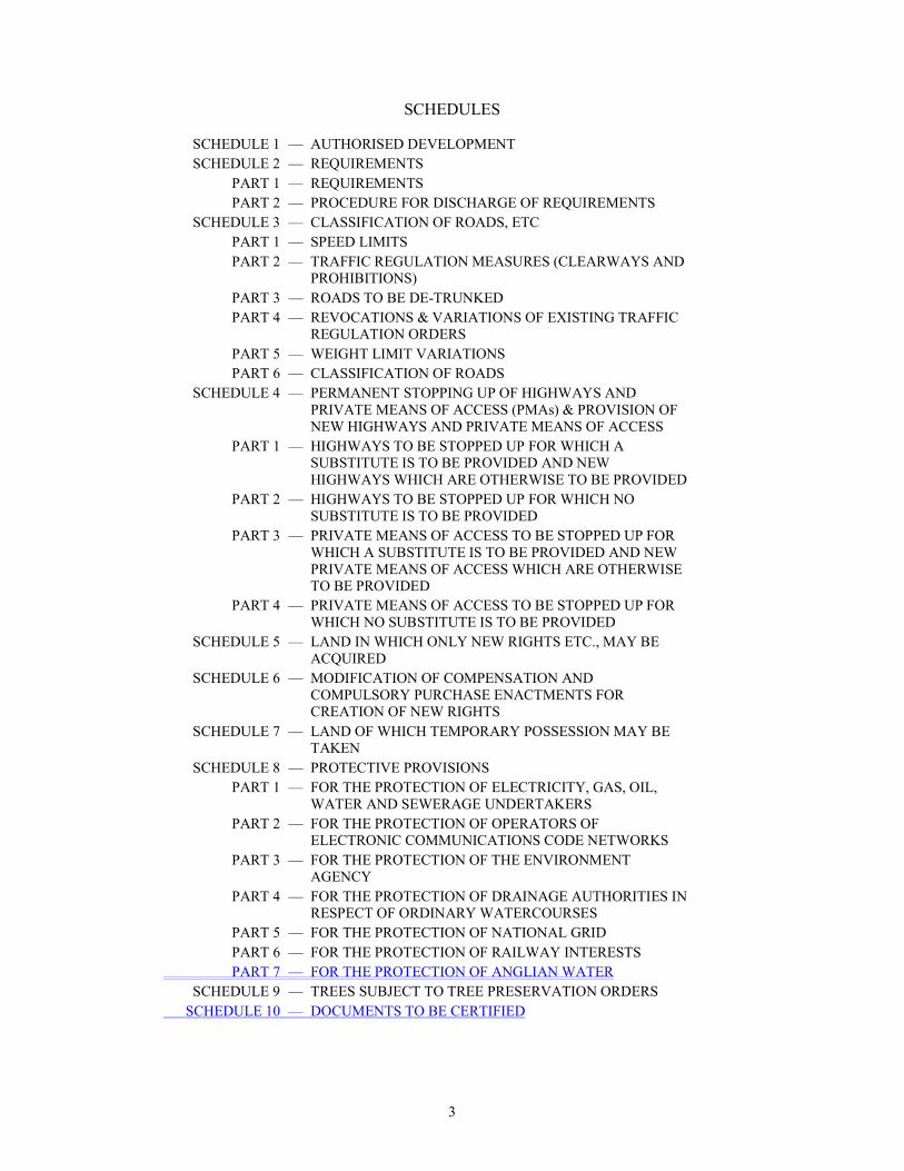
SCHEDULES
SCHEDULE 1 — AUTHORISED DEVELOPMENT
SCHEDULE 2 — REQUIREMENTS
PART 1 — REQUIREMENTS
PART 2 — PROCEDURE FOR DISCHARGE OF REQUIREMENTS
SCHEDULE 3 — CLASSIFICATION OF ROADS, ETC
PART 1 — SPEED LIMITS
PART 2 — TRAFFIC REGULATION MEASURES (CLEARWAYS AND
PROHIBITIONS)
PART 3 — ROADS TO BE DE-TRUNKED
PART 4 — REVOCATIONS & VARIATIONS OF EXISTING TRAFFIC
REGULATION ORDERS
PART 5 — WEIGHT LIMIT VARIATIONS
PART 6 — CLASSIFICATION OF ROADS
SCHEDULE 4 — PERMANENT STOPPING UP OF HIGHWAYS AND
PRIVATE MEANS OF ACCESS (PMAs) & PROVISION OF
NEW HIGHWAYS AND PRIVATE MEANS OF ACCESS
PART 1 — HIGHWAYS TO BE STOPPED UP FOR WHICH A
SUBSTITUTE IS TO BE PROVIDED AND NEW
HIGHWAYS WHICH ARE OTHERWISE TO BE PROVIDED
PART 2 — HIGHWAYS TO BE STOPPED UP FOR WHICH NO
SUBSTITUTE IS TO BE PROVIDED
PART 3 — PRIVATE MEANS OF ACCESS TO BE STOPPED UP FOR
WHICH A SUBSTITUTE IS TO BE PROVIDED AND NEW
PRIVATE MEANS OF ACCESS WHICH ARE OTHERWISE
TO BE PROVIDED
PART 4 — PRIVATE MEANS OF ACCESS TO BE STOPPED UP FOR
WHICH NO SUBSTITUTE IS TO BE PROVIDED
SCHEDULE 5 — LAND IN WHICH ONLY NEW RIGHTS ETC., MAY BE
ACQUIRED
SCHEDULE 6 — MODIFICATION OF COMPENSATION AND
COMPULSORY PURCHASE ENACTMENTS FOR
CREATION OF NEW RIGHTS
SCHEDULE 7 — LAND OF WHICH TEMPORARY POSSESSION MAY BE
TAKEN
SCHEDULE 8 — PROTECTIVE PROVISIONS
PART 1 — FOR THE PROTECTION OF ELECTRICITY, GAS, OIL,
WATER AND SEWERAGE UNDERTAKERS
PART 2 — FOR THE PROTECTION OF OPERATORS OF
ELECTRONIC COMMUNICATIONS CODE NETWORKS
PART 3 — FOR THE PROTECTION OF THE ENVIRONMENT
AGENCY
PART 4 — FOR THE PROTECTION OF DRAINAGE AUTHORITIES IN
RESPECT OF ORDINARY WATERCOURSES
PART 5 — FOR THE PROTECTION OF NATIONAL GRID
PART 6 — FOR THE PROTECTION OF RAILWAY INTERESTS
PART 7 — FOR THE PROTECTION OF ANGLIAN WATER
SCHEDULE 9 — TREES SUBJECT TO TREE PRESERVATION ORDERS
SCHEDULE 10 — DOCUMENTS TO BE CERTIFIED
4
An application has been made to the Secretary of State, under section 37 of the Planning Act
2008(a) (“the 2008 Act”) in accordance with the Infrastructure Planning (Applications: Prescribed
Forms and Procedure) Regulations 2009(b) for an Order granting development consent.
The application was examined by a Panel of four members (“the Panel”) (appointed by the
Secretary of State) pursuant to Chapter 3 of Part 6 of the 2008 Act and carried out in accordance
with Chapter 4 of Part 6 of the 2008 Act, and the Infrastructure Planning (Examination Procedure)
Rules 2010(c).
The Panel, having examined the application with the documents that accompanied the application,
and the representations made and not withdrawn, has, in accordance with section 83(1) of the 2008
Act, made a report and recommendation to the Secretary of State.
The Secretary of State, having considered the representations made and not withdrawn, and the
report of the Panel, has decided to make an Order granting development consent for the
development described in the application [with modifications which in the opinion of the
Secretary of State do not make any substantial changes to the proposals comprised in the
application].
In accordance with section 131(5) of the 2008 Act, the Secretary of State is satisfied, having
considered the report and recommendation of the Panel, that the parcels of common, open space or
fuel or field garden allotment land comprised within the Order land are less than 200 square
metres in extent individually, or that this land is required for the widening or drainage of an
existing highway or partly for the widening and partly for the drainage of such a highway, and that
the giving in exchange of other land is unnecessary, whether in the interests of the persons, if any,
entitled to rights of common or other rights or in the interests of the public.
The Secretary of State, in exercise of the powers conferred by sections 114, 115, 120 and 122 of,
and paragraphs 1 to 4, 10 to 17, 19 to 23, 26, 33, 36 and 37 of Part 1 of Schedule 5 to, the 2008
Act, makes the following Order—
PART 1
PRELIMINARY
Citation and commencement
1. This Order may be cited as the A14 Cambridge to Huntingdon Improvement Scheme
Development Consent Order 201[ ] and comes into force on [ ] 201[ ].
Interpretation
2.—(1) In this Order—
“the 1961 Act” means the Land Compensation Act 1961(d);
(a) 2008 c.29. Parts 1 to 7 were amended by Chapter 6 of Part 6 of the Localism Act 2011 (c.20). (b) S.I. 2009/2264, amended by S.I. 2010/439, S.I. 2010/602, S.I. 2012/635, S.I. 2012/2654, S.I. 2012/2732, S.I. 2013/522 and
S.I. 2013/755. (c) S.I. 2010/103, amended by S.I. 2012/635. (d) 1961 c.33. Section 2(2) was amended by section 193 of, and paragraph 5 of Schedule 33 to, the Local Government,
Planning and Land Act 1980 (c.65). There are other amendments to the 1980 Act which are not relevant to this Order.
5
“the 1965 Act” means the Compulsory Purchase Act 1965(a);
“the 1980 Act” means the Highways Act 1980(b);
“the 1981 Act” means the Compulsory Purchase (Vesting Declarations) Act 1981(c);
“the 1984 Act” means the Road Traffic Regulation Act 1984(d);
“the 1990 Act” means the Town and Country Planning Act 1990(e);
“the 1991 Act” means the New Roads and Street Works Act 1991(f);
“the 2008 Act” means the Planning Act 2008(g);
“address” includes any number or address for the purposes of electronic transmission;
“apparatus” has the same meaning as in Part 3 of the 1991 Act;
“the authorised development” means the development and associated development described
in Schedule 1 (authorised development) and any other development authorised by this Order,
which is development within the meaning of section 32 (meaning of development) of the 2008
Act;
“the book of reference” means the book of reference with document reference [XXX] of that
description set out in Schedule 10 certified by the Secretary of State as the book of reference
for the purposes of this Order;
“the borrow pits” means the borrow pits shown on the engineering section drawings and
sections and the works plans;
“bridleway” has the same meaning as in the 1980 Act;
(a) 1965 c.56. Section 3 was amended by section 70 of, and paragraph 3 of Schedule 15 to, the Planning and Compensation Act
1991 (c.34). Section 4 was amended by section 3 of, and Part 1 of Schedule 1 to, the Housing (Consequential Provisions) Act 1985 (c.71). Section 5 was amended by sections 67 and 80 of, and Part 2 of Schedule 18 to, the Planning and Compensation Act 1991 (c.34). Section 11(1) and sections 3, 31 and 32 were amended by section 34(1) of, and Schedule 4 to, the Acquisition of Land Act 1981 (c.67) and by section 14 of, and paragraph 12(1) of Schedule 5 to, the Church of England (Miscellaneous Provisions) Measure 2006 (2006 No.1). Section 12 was amended by section 56(2) of, and Part 1 to Schedule 9 to, the Courts Act 1971 (c.23). Section 13 was amended by section 139 of the Tribunals, Courts and Enforcement Act 2007 (c.15). Section 20 was amended by section 70 of, and paragraph 14 of Schedule 15 to, the Planning and Compensation Act 1991 (c.34). Sections 9, 25 and 29 were amended by the Statute Law (Repeals) Act 1973 (c.39). Section 31 was also amended by section 70 of, and paragraph 19 of Schedule 15 to, the Planning and Compensation Act 1991 (c.34) and by section 14 of, and paragraph 12(2) of Schedule 5 to, the Church of England (Miscellaneous Provisions) Measure 2006 (2006 No.1). There are other amendments to the 1965 Act which are not relevant to this Order.
(b) 1980 c.66. Section 1(1) was amended by section 21(2) of the New Roads and Street Works Act 1991 (c.22); sections 1(2), (3) and (4) were amended by section 8 of, and paragraph (1) of Schedule 4 to, the Local Government Act 1985 (c.51); section 1(2A) was inserted by, and section 1(3) was amended by, section 259 (1), (2) and (3) of the Greater London Authority Act 1999 (c.29); sections 1(3A) and 1(5) were inserted by section 22(1) of, and paragraph 1 of Schedule 7 to, the Local Government (Wales) Act 1994 (c.19). Section 36(2) was amended by section 4(1) of, and paragraphs 47 (a) and (b) of Schedule 2 to, the Housing (Consequential Provisions) Act 1985 (c.71), by S.I. 2006/1177, by section 4 of and paragraph 45(3) of Schedule 2 to, the Planning (Consequential Provisions) Act 1990 (c.11), by section 64(1) (2) and (3) of the Transport and Works Act 1992 (c.42) and by section 57 of, and paragraph 5 of Part 1 of Schedule 6 to, the Countryside and Rights of Way Act 2000 (c.37); section 36(3A) was inserted by section 64(4) of the Transport and Works Act 1992 and was amended by S.I. 2006/1177; section 36(6) was amended by section 8 of, and paragraph 7 of Schedule 4 to, the Local Government Act 1985 (c.51); and section 36(7) was inserted by section 22(1) of, and paragraph 4 of Schedule 7 to, the Local Government (Wales) Act 1994 (c.19). Section 329 was amended by section 112(4) of, and Schedule 18 to, the Electricity Act 1989 (c.29) and by section 190(3) of, and Part 1 of Schedule 27 to, the Water Act 1989 (c.15). There are other amendments to the 1980 Act which are not relevant to this Order.
(c) 1981 c.66. Sections 2(3), 6(2) and 11(6) were amended by section 4 of, and paragraph 52 of Schedule 2 to, the Planning (Consequential Provisions) Act 1990 (c.11). Section 15 was amended by sections 56 and 321(1) of, and Schedules 8 and 16 to, the Housing and Regeneration Act 2008 (c.17). Paragraph 1 of Schedule 2 was amended by section 76 of, and Part 2 of Schedule 9 to, the Housing Act 1988 (c.50); section 161(4) of, and Schedule 19 to, the Leasehold Reform, Housing and Urban Development Act 1993 (c.28); and sections 56 and 321(1) of, and Schedule 8 to, the Housing and Regeneration Act 2008. Paragraph 3 of Schedule 2 was amended by section 76 of, and Schedule 9 to, the Housing Act 1988 and section 56 of, and Schedule 8 to, the Housing and Regeneration Act 2008. Paragraph 2 of Schedule 3 was repealed by section 277 of, and Schedule 9 to, the Inheritance Tax Act 1984 (c.51). There are amendments to the 1981Act which are not relevant to this Order.
(d) 1984 c.27. (e) 1990 c.8. Section 206(1) was amended by section 192(8) to, and paragraphs 7 and 11 of Schedule 8 to, the Planning Act
2008 (c.29) (date in force to be appointed see section 241(3), (4)(a),(c) of the 2008 Act). There are other amendments to the 1990 Act which are not relevant to this Order.
(f) 1991 c.22. Section 48(3A) was inserted by section 124 of the Local Transport Act 2008 (c.26). Sections 79(4), 80(4), and 83(4) were amended by section 40 of, and Schedule 1 to, the Traffic Management Act 2004 (c.18).
(g) 2008 c.29.
6
“building” includes any structure or erection or any part of a building, structure or erection;
“carriageway” has the same meaning as in the 1980 Act;
“the classification of roads plans” means the plans of that description set out in Schedule 10
certified by the Secretary of State as the classification of roads plans for the purposes of this
Order;
“commence” means beginning to carry out any material operation (as defined in section 56(4)
of the 1990 Act) forming part of the authorised development other than operations consisting
of archaeological investigations, non-intrusive investigations for the purpose of assessing
ground conditions, remedial work in respect of any contamination or other adverse ground
conditions, erection of any temporary means of enclosure, and the temporary display of site
notices or advertisements, and “commencement” is to be construed accordingly;
“construct” includes execution, placing, altering, replacing, relaying and removal and
“construction” is to be construed accordingly;
“the Crown land plans” means the plans of that description set out in Schedule 10 certified by
the Secretary of State as the crown Crown land plans for the purposes of this Order;
“cycle track” has the same meaning as in section 329(1) (further provisions as to
interpretation) of the 1980 Act(a);
“the de-trunking plans” means the plans of that description set out in Schedule 10 certified by
the Secretary of State as the de-trunking plans for the purposes of this Order;
“electronic transmission” means a communication transmitted—
(a) by means of an electronic communications network; or
(b) by other means but while in electronic form;
“the engineering section drawings and sections” means the documents of that description set
out in Schedule 10 certified by the Secretary of State as the engineering section drawings and
sections for the purposes of this Order;
“the environmental statement” means the document with reference number [XXX], together
with other supplementary documents, namely [XXX] with document reference number
[XXX], documents of that description set out in Schedule 10 certified by the Secretary of State
as the environmental statement for the purposes of this Order;
“the flood compensation areas” means the flood compensation areas shown on the engineering
section drawings and sections and the works plans;
“footpath” and “footway” have the same meaning as in the 1980 Act;
“the general arrangement drawings” means the drawings of that description set out in
Schedule 10 certified by the Secretary of State as the general arrangement drawings for the
purposes of this Order;
“highway”, “highway authority” and “local highway authority” have the same meaning as in
the 1980 Act;
“the land plans” means the plans of that description set out in Schedule 10 certified by the
Secretary of State as the land plans for the purposes of this Order;
“the limits of deviation” means the limits of deviation referred to in article 7 (limits of
deviation);
“maintain” and any of its derivatives include inspect, repair, adjust, alter, remove or
reconstruct and any derivative of “maintain” is to be construed accordingly;
“NMU” means non-motorised user;
“the Order land” means the land shown on the land plans which is within the limits of land to
be acquired or used permanently or temporarily, and described in the book of reference;
(a) The definition of “cycle track” was amended by section 1 of the Cycle Tracks Act 1984 (c.38) and paragraph 21(2) of
Schedule 3 to the Road Traffic (Consequential Provisions) Act 1988 (c.54).
7
“the Order limits” means the limits of deviation shown on the works plans, and the limits of
land to be acquired or used permanently or temporarily shown on the land plans, within which
the authorised development may be carried out;
“owner”, in relation to land, has the same meaning as in section 7 of the Acquisition of Land
Act 1981(a) (interpretation);
“the relevant planning authority” means the local planning authority for the land and matter in
question, being Cambridgeshire County Council, Huntingdonshire District Council or South
Cambridgeshire District Council;
“the rights of way and access plans” means the plans of that description set out in Schedule 10
certified by the Secretary of State as the rights of way and access plans for the purposes of this
Order;
“the Secretary of State” means the Secretary of State for Transport;
“the special category land plans” means the plans of that description set out in Schedule 10
certified by the Secretary of State as the special category land plans for the purposes of this
Order;
“special road” means a highway which is a special road in accordance with section 16 of the
1980 Act (general provisions as to special roads) or by virtue of an order granting
development consent;
“statutory undertaker” means any statutory undertaker for the purposes of section 127(8)
(statutory undertakers’ land) of the 2008 Act;
“street” means a street within the meaning of section 48 of the 1991 Act (streets, street works
and undertakers), together with land on the verge of a street or between two carriageways, and
includes part of a street;
“street authority”, in relation to a street, has the same meaning as in Part 3 of the 1991 Act;
“traffic authority” has the same meaning as in section 121A of the 1984 Act;
“the traffic regulation measures plans” means the plans relating to speed limits and
prohibitions, and clearways and weight limit, of that description set out in Schedule 10
certified by the Secretary of State as being the traffic regulation measures plans for the
purposes of this Order;
“the tribunal” means the Lands Chamber of the Upper Tribunal;
“trunk road” means a highway which is a trunk road by virtue of—
(a) section 10 or 19(1) of the 1980 Act (provisions as to trunk roads);
(b) an order made or direction given under section 10 of that Act;
(c) an order granting development consent; or
(d) any other enactment;
“the variation of special road status plans” means the plans of that description set out in
Schedule 10 certified by the Secretary of State as the variation of special road status plans for
the purposes of this Order;
“watercourse” includes all rivers, streams, ditches, drains, canals, cuts, culverts, dykes,
sluices, sewers and passages through which water flows except a public sewer or drain;
“the works plans” means the plans of that description set out in Schedule 10 certified by the
Secretary of State as the works plans for the purposes of this Order; and
“the undertaker” means Highways England Company Limited (Company No. 09346363) of
Bridge House, 1 Walnut Tree Close, Guildford, Surrey, GU1 4LZ.
(2) References in this Order to rights over land include references to rights to do or to place and
maintain, anything in, on or under land or in the airspace above its surface and references in this
Order to the imposition of restrictive covenants are references to the creation of rights over land
(a) 1981 c.67.
8
which interfere with the interests or rights of another and are for the benefit of land which is
acquired under this Order or is otherwise comprised in the Order land.
(3) All distances, directions and lengths referred to in this Order are approximate and distances
between points on a work comprised in the authorised development are taken to be measured
along that work.
(4) For the purposes of this Order, all areas described in square metres in the book of reference
are approximate.
(5) References in this Order to points identified by letters or numbers are to be construed as
references to points so lettered or numbered on the rights of way and access plans.
(6) References in this Order to numbered works are references to the works as numbered in
Schedule 1 (authorised development).
Disapplication of legislative provisions
3.—(1) The following provisions do not apply in relation to the construction of any work or the
carrying out of any operation required for the purpose of, or in connection with, the construction
of the authorised development—
(a) section 109 (structures in, over or under a main river) of the Water Resources Act
1991(a);
(b) the provisions of any byelaws made under, or having effect as if made under, paragraphs
5, 6 or 6A of Schedule 25 to the Water Resources Act 1991;
(c) section 23 (prohibition of obstructions, etc. in watercourses) of the Land Drainage Act
1991(b);
(d) section 32 (variation of awards) of the Land Drainage Act 1991;
(e) the provisions of any byelaws made under section 66 (powers to make byelaws) of the
Land Drainage Act 1991; and
(f) section 28E (duties in relation to sites of scientific interest) of the Wildlife and
Countryside Act 1981(c).
(2) The Anglian Authority Water Act 1977(d) has effect subject to the provisions of this Order
and sections 18, 27 and 28 of that Act, and any byelaws made and having effect under section 18,
do not apply in relation to anything done or omitted to be done in connection with construction of
the authorised development.
Maintenance of drainage works
4.—(1) Nothing in this Order, or the construction, maintenance or operation of the authorised
development under it, affects any responsibility for the maintenance of any works connected with
the drainage of land, whether that responsibility is imposed or allocated by or under any
enactment, or otherwise, unless otherwise agreed in writing between the undertaker and the person
responsible.
(2) In this article “drainage” has the same meaning as in section 72 (interpretation) of the Land
Drainage Act 1991.
(a) 1991 c.57. (b) 1991 c.59. (c) 1981 c.69. (d) 1977 c.i.
9
PART 2
PRINCIPAL POWERS
Development consent, etc., granted by the Order
5.—(1) Subject to the provisions of this Order, including the requirements in Schedule 2
(requirements), the undertaker is granted development consent for the authorised development to
be carried out within the Order limits.
(2) Any enactment applying to land within or adjacent to the Order limits will have effect
subject to the provisions of this Order.
Maintenance of the authorised development
6.—(1) The undertaker may at any time maintain the authorised development, except to the
extent that this Order or an agreement made under this Order provides otherwise.
(2) Paragraph (1) does not extend to any maintenance works which would give rise to any
materially new or materially worse environmental effects from those assessed in the
environmental statement.
Limits of deviation
7. In carrying out the authorised development the undertaker may—
(a) deviate laterally from the lines or situations of the authorised development shown on the
works plans to the extent of the limits of deviation shown on those plans; and
(b) deviate vertically from the levels of the authorised development shown on the
engineering drawings and sections—section drawings—
(i) to a maximum of 0.5 metres upwards or downwards; or
(ii) in respect of the excavation of the borrow pits or the flood compensation areas, to a
maximum of 0.5 metres downwards but to any distance upwards to ground level,
except that these maximum limits of vertical deviation do not apply where it is
demonstrated by the undertaker to the Secretary of State’s satisfaction and the Secretary
of State, following consultation with the relevant planning authority, certifies accordingly
that a deviation in excess of these limits would not give rise to any materially new or
materially worse adverse environment environmental effects from those assessed in the
environmental statement.
Benefit of Order
8.—(1) Subject to article 9 (consent to transfer benefit of Order) and paragraph (2), the
provisions of this Order conferring powers on the undertaker have effect solely for the benefit of
the undertaker.
(2) Paragraph (1) does not apply to the works for which the consent is granted by this Order for
the express benefit of owners and occupiers of land, statutory undertakers and other persons
affected by the authorised development.
Consent to transfer benefit of Order
9.—(1) The undertaker may with the consent of the Secretary of State—
(a) transfer to another person (“the transferee”) any or all of the benefit of the provisions of
this Order and such related statutory rights as may be agreed between the undertaker and
the transferee; or
10
(b) grant to another person (“the lessee”) for a period agreed between the undertaker and the
lessee any or all of the benefit of the provisions of this Order and such related statutory
rights as may be so agreed.
(2) Where an agreement has been made in accordance with paragraph (1) references in this
Order to the undertaker, except in paragraph (3), includes include references to the transferee or
the lessee.
(3) The exercise by a person of any benefits or rights conferred in accordance with any transfer
or grant under paragraph (1) is subject to the same restrictions, liabilities and obligations as would
apply under this Order if those benefits or rights were exercised by the undertaker.
PART 3
STREETS
Application of the 1991 Act
10.—(1) Works executed under this Order in relation to a highway which consists of or includes
a carriageway are to be treated for the purposes of Part 3 (street works in England and Wales) of
the 1991 Act as major highway works if—
(a) they are of a description mentioned in any of paragraphs (a), (c) to (e), (g) and (h) of
section 86(3) (which defines what highway authority works are major highway works) of
that Act; or
(b) they are works which, had they been executed by the highway authority, might have been
carried out in exercise of the powers conferred by section 64 (dual carriageways and
roundabouts) of the 1980 Act or section 184 (vehicle crossings over footways and verges)
of that Act.
(2) In Part 3 of the 1991 Act references, in relation to major highway works, to the highway
authority concerned are, in relation to works which are major highway works by virtue of
paragraph (1), to be construed as references to the undertaker.
(3) The following provisions of the 1991 Act do not apply in relation to any works executed
under the powers of this Order—
section 56 (directions as to timing);
section 56A (power to give directions as to placing of apparatus);
section 58 (restrictions following substantial road works);
section 58A (restriction on works following substantial street works);
section 73A (power to require undertaker to re-surface street);
section 73B (power to specify timing etc. of re-surfacing);
section 73C (materials, workmanship and standard of re-surfacing);
section 78A (contributions to costs of re-surfacing by undertaker); and
Schedule 3A (restriction on works following substantial street works).
(4) The provisions of the 1991 Act mentioned in paragraph (5) (which, together with other
provisions of that Act, apply in relation to the execution of street works) and any regulations
made, or code of practice issued or approved under, those provisions apply (with the necessary
modifications) in relation to any stopping up, alteration or diversion of a street of a temporary
nature by the undertaker under the powers conferred by article 14 (temporary stopping up and
restriction of use of streets) whether or not the stopping up, alteration or diversion constitutes
street works within the meaning of that Act.
11
(5) The provisions of the 1991 Act(a) referred to in paragraph (4) are—
section 54(b) (advance notice of certain works), subject to paragraph (6);
section 55(c) (notice of starting date of works), subject to paragraph (6);
section 57(d) (notice of emergency works);
section 59(e) (general duty of street authority to co-ordinate works);
section 60 (general duty of undertakers to co-operate);
section 68 (facilities to be afforded to street authority);
section 69 (works likely to affect other apparatus in the street);
section 75 (inspection fees);
section 76 (liability for cost of temporary traffic regulation); and
section 77 (liability for cost of use of alternative route),
and all such other provisions as apply for the purposes of the provisions mentioned above.
(6) Sections 54 and 55 of the 1991 Act as applied by paragraph (4) have effect as if references in
section 57 of that Act to emergency works were a reference to a stopping up, alteration or
diversion (as the case may be) required in a case of emergency.
(7) Nothing in article 11 (construction and maintenance of new, altered or diverted streets and
other structures)—
(a) affects the operation of section 87 (prospectively maintainable highways) of the 1991
Act, and the undertaker is not by reason of any duty under that article to maintain a street
to be taken to be the street authority in relation to that street for the purposes of Part 3 of
that Act; or
(b) has effect in relation to street works as respects which the provisions of Part 3 of the 1991
Act apply.
Construction and maintenance of new, altered or diverted streets and other structures
11.—(1) Subject to paragraphs (6), (7) and (8), any highway (other than a trunk road or special
road) to be constructed under this Order must be completed to the reasonable satisfaction of the
local highway authority in whose area the highway lies and, unless otherwise agreed in writing
with the local highway authority, the highway including any culverts or other structures laid under
it must be maintained by and at the expense of the local highway authority from its completion.
(2) Subject to paragraphs (3), (6), (7) and (8), where a highway (other than a trunk road or
special road) is altered or diverted under this Order, the altered or diverted part of the highway
must be completed to the reasonable satisfaction of the local highway authority and, unless
otherwise agreed in writing with the local highway authority, that part of the highway including
any culverts or other structures laid under it must be maintained by and at the expense of the local
highway authority from its completion.
(3) Subject to paragraphs (6), (7) and (8), where a footpath, cycle track or bridleway is altered or
diverted under this Order along a vehicular private means of access, the altered or diverted part of
the highway must, when completed to the reasonable satisfaction of the highway authority and
unless otherwise agreed in writing, be maintained (including any culverts or other structures laid
under that part of the highway) by and at the expense of the person or persons with the benefit of
the vehicular private means of access.
(4) (2)Where a street which is not and is not intended to be a public highway is constructed,
altered or diverted under this Order, the street (or part of the street as the case may be) must, when
(a) Sections 54, 55, 57, 60, 68 and 69 were amended by section 40(1) and (2) of, and Schedule 1 to, the Traffic Management
Act 2004 (c.18). (b) As also amended by section 49(1) of the Traffic Management Act 2004. (c) As also amended by section 49(2) and 51(9) of the Traffic Management Act 2004. (d) As also amended by section 52(3) of the Traffic Management Act 2004. (e) As amended by section 42 of the Traffic Management Act 2004.
12
completed to the reasonable satisfaction of the street authority, unless otherwise agreed in writing,
be maintained by and at the expense of the undertaker for a period of 12 months from its
completion and at the expiry of that period by and at the expense of the street authority.
(5) (3)Subject to paragraphs (6), (7) and (8), where a highway is de-trunked under this Order—
(a) section 265 (transfer of property and liabilities upon a highway becoming or ceasing to be
a trunk road) of the 1980 Act applies in respect of that highway; and
(b) any alterations to that highway undertaken under powers conferred by this Order prior to
and in connection with that de-trunking must, unless otherwise agreed in writing with the
local highway authority, be maintained by and at the expense of the local highway
authority from the date of de-trunking.
(4) For the avoidance of doubt, in respect of any highway (other than a trunk road or special
road) constructed, altered or diverted under paragraphs (1) and (2) above, any culverts or other
structures laid under that highway are to be treated as part of that highway and therefore
maintainable by and at the expense of the local highway authority from its completion.
(6) In the case of any bridge constructed under this Order to carry a highway other than a trunk
road or special road over a trunk road or special road, the highway surface must from its
completion be maintained by and at the expense of the local highway authority and the structure of
the bridge must be maintained by and at the expense of the undertaker.
(7) In the case of any bridge constructed under this Order to carry a highway (other than a trunk
road or special road) over another highway which is not a trunk road or a special road, both the
highway surface and structure of the bridge must be maintained by and at the expense of the local
highway authority from their completion.
(8) In the case of a bridge constructed under this Order to carry a private right of way (whether
or not it also carries a footpath, cycle track or bridleway), the surface and the structure of the
bridge must be maintained by and at the expense of the undertaker.
(9) In any action against the undertaker in respect of loss or damage resulting from any failure
by the undertaker to maintain a street under this article, it is a defence (without prejudice to any
other defence or the application of the law relating to contributory negligence) to prove that the
undertaker had taken such care as in all the circumstances was reasonably required to secure that
the part of the street to which the action relates was not dangerous to traffic.
(10) For the purposes of a defence under paragraph (9), the court must in particular have regard
to the following matters—
(a) the character of the street and the traffic which was reasonably to be expected to use it;
(b) the standard of maintenance appropriate for a street of that character and used by such
traffic;
(c) the state of repair in which a reasonable person would have expected to find the street;
(d) whether the undertaker knew, or could reasonably have been expected to know, that the
condition of the part of the street to which the action relates was likely to cause danger to
users of the street; and
(e) where the undertaker could not reasonably have been expected to repair that part of the
street before the cause of action arose, what warning notices of its condition had been
displayed,
but for the purposes of such a defence it is not relevant to prove that the undertaker had arranged
for a competent person to carry out or supervise the maintenance of the part of the street to which
the action relates unless it is also proved that the undertaker had given the competent person
proper instructions with regard to the maintenance of the street and that the competent person had
carried out those instructions.
Classification of roads, etc.
12.—(1) On a date to be determined by the undertaker, and subject to the procedures in
paragraph (2) being satisfied the M11 London - Cambridge Motorway (Cambridge Western

13
Bypass Section) Scheme 1974 is varied so that in the Schedule to that Scheme, in the paragraph
entitled “The Route of the Special Road”, for the words “terminating at a point on the road from
Cambridge to Godmanchester (A604) about 280m south-east of its junction with C194 The
Avenue, Girton.” there are substituted the words—
“terminating at a point on the road from Felixstowe to Catthorpe (A14) about 452m north
west of the centreline of the M11 underbridge structure for A1307 Huntingdon Road
(‘Bulls Close Bridge’), Girton.”.
(2) Before the date on which paragraph (1) is to take effect, the undertaker must publish in The
London Gazette, and in one or more newspapers circulating in the vicinity of the authorised
development, notification of the date on which paragraph (1) takes effect, and the general effect of
that paragraph.
(3) On the date on which the roads described in Part 6 of Schedule 3 (classification of roads, etc
– classification of roads) are completed and open for traffic—
(a) the roads described in paragraphs 1 to 8 20 of Part 6 of Schedule 3 are to become trunk
roads as if they had become so by virtue of an order made under section 10(2) (general
provision as to trunk roads) of the 1980 Act specifying that date as the date on which they
were to become trunk roads; and
(b) the road described in paragraph 9 21 of Part 6 of Schedule 3 is to be classified as the
A141 and the road described in paragraph 10 paragraphs 22 to 24 of Part 6 of Schedule 3
is to be classified as the A1307 and both these roads are to be—
(i) a principal road for the purpose of any enactment or instrument which refers to
highways classified as principal roads; and
(ii) a classified road for the purpose of any enactment or instrument which refers to
highways classified as classified roads,
as if such classification had been made under section 12(3) (general provision as to
principal and classified roads) of the 1980 Act, and
(c) the roads described in paragraphs 11 to 20 25 to 35 of Part 6 of Schedule 3 are to be
classified as set out in paragraphs 11 to 20 25 to 35 of Part 6 of Schedule 3 and are to be a
classified road for the purpose of any enactment or instrument which refers to highways
classified as classified roads, as if such classification had been made under section 12(3)
of the 1980 Act.
(4) On Subject to paragraph (5), on such day as the undertaker may determine, the roads
described in Part 3 of Schedule 3 (classification of roads, etc. – roads to be de-trunked) are to
cease to be trunk roads as if they had ceased to be trunk roads by virtue of an order made under
section 10(2) of the 1980 Act specifying that date as the date on which they were to cease to be
trunk roads.
(5) The undertaker may only make a determination for the purposes of paragraph (4) with the
consent of the Secretary of State, who must consult the local highway authority before deciding
whether to give that consent.
(6) (4)From such day as the undertaker may determine no person is to drive any motor vehicle at
a speed exceeding the limit in miles per hour specified in column (3) of Part 1 of Schedule 3
(classification of roads, etc. – speed limits) along the lengths of road identified in the
corresponding row of column (2) of that Part.
(7) (5)Subject to paragraph (8)7 and article 16 (clearways), from such a day as the undertaker
may determine, the restrictions specified in column (3) of Part 2 of Schedule 3 (classification of
roads, etc. – traffic regulation measures (clearways and prohibitions)) are to apply to the lengths of
road identified in the corresponding row of column (2) of that Part.
(8) (6)The restrictions provided for in paragraph (7)6 do not apply to any an authorised vehicle
where the vehicle is excepted from the restrictions in column (3) of Part 2 of Schedule 3.
(9) (7)On such day as the undertaker may determine, the orders specified in column (3) of Parts
4 and 5 of Schedule 3 are to be varied or revoked as specified in the corresponding row of Column
14
4 of those Parts in respect of the lengths of roads specified in the corresponding row of Column 2
of those Parts.
(10) (8)Paragraphs (1) to (9)8 may be varied or revoked by any instrument made under any
enactment which provides for the variation or revocation of such matters.
(11) (9)No speed limit imposed by this Order applies to vehicles falling within regulation 3(4) of
the Road Traffic Exemptions (Special Forces) (Variation and Amendment) Regulations 2011(a)
when used in accordance with regulation 3(5) of those regulations.
(12) (10)In this article, “authorised vehiclesvehicle” means any a vehicle specified by the
undertaker from time to time.
Permanent stopping up of streets and private means of access
13.—(1) Subject to the provisions of this article, the undertaker may, in connection with the
carrying out of the authorised development, stop up each of the streets and private means of access
specified in columns (1) and (2) of Parts 1, 2, 3 and 4 of Schedule 4 (permanent stopping up of
highways and private means of access (PMAs) & provision of new highways and private means of
access) to the extent specified and described in column (3) of those Parts of that Schedule.
(2) No street or private means of access specified in columns (1) and (2) of Parts 1 and 3 of
Schedule 4 (being a street to be stopped up for which a substitute is to be provided) is to be wholly
or partly stopped up under this article unless—
(a) the new street or private means of access to be constructed and substituted for it, which is
specified in column (4) of that Part of that Schedule, has been completed to the
reasonable satisfaction of the street authority and is open for use; or
(b) a temporary alternative route for the passage of such traffic as could have used the street
or private means of access to be stopped up is first provided and subsequently maintained
by the undertaker, to the reasonable satisfaction of the street authority, between the
commencement and termination points for the stopping up of the street or private means
of access until the completion and opening of the new street or private means of access in
accordance with sub-paragraph (a).
(3) No street or private means of access specified in columns (1) and (2) of Parts 2 and 4 of
Schedule 4 (being a street or private access to be stopped up for which no substitute is to be
provided) is to be wholly or partly stopped up under this article unless the condition specified in
paragraph (4) is satisfied in relation to all of the land which abuts on either side of the street or
private means of access to be stopped up.
(4) The condition referred to in paragraph (3) is that—
(a) the undertaker is in possession of the land;
(b) there is no right of access to the land from the street or private means of access
concerned;
(c) there is reasonably convenient access to the land otherwise than from the street or private
means of access concerned; or
(d) the owners and occupiers of the land have agreed to the stopping up.
(5) Where a street or private means of access has been stopped up under this article—
(a) all rights of way over or along the street or private means of access so stopped up are
extinguished; and
(b) the undertaker may appropriate and use for the purposes of the authorised development so
much of the site of the street or private means of access as is bounded on both sides by
land owned by the undertaker.
(a) S.I. 2011/935.
15
(6) Any person who suffers loss by the suspension or extinguishment of any private right of way
under this article is entitled to compensation to be determined, in case of dispute, under Part 1 of
the 1961 Act.
(7) This article is subject to article 33 (apparatus and rights of statutory undertakers in stopped
up streets).
Temporary stopping up and restriction of use of streets
14.—(1) The undertaker may, during and for the purposes of carrying out the authorised
development, temporarily stop up, alter or divert any street and may for any reasonable time—
(a) divert the traffic from the street; and
(b) subject to paragraph (3), prevent all persons from passing along the street.
(2) Without limitation on the scope of paragraph (1), the undertaker may use any street
temporarily stopped up under the powers conferred by this article and within the Order limits as a
temporary working site.
(3) The undertaker must provide reasonable access for pedestrians going to or from premises
abutting a street affected by the temporary stopping up, alteration or diversion of a street under
this article if there would otherwise be no such access.
(4) The undertaker must not temporarily stop up, alter or divert any street for which it is not the
street authority without the consent of the street authority, which may attach reasonable conditions
to any consent but its consent must not be unreasonably withheld or delayed.
(5) Any person who suffers loss by the suspension of any private right of way under this article
is entitled to compensation to be determined, in case of dispute, under Part 1 of the 1961 Act.
(6) If a street authority which has received an application for consent under paragraph (4) fails
to notify the undertaker of its decision before the end of the period of 28 days beginning with the
date on which the application was made, it is deemed to have granted consent.
Access to works
15. The undertaker may, for the purposes of the authorised development, form and lay out
means of access, or improve existing means of access at such locations within the Order limits as
the undertaker reasonably requires for the purposes of the authorised development.
Clearways
16.—(1) On From such day as the undertaker may determine, save as provided in paragraph (2)
below, no person is to cause or permit any vehicle to wait on any part of the lengths of road
described in column (2) of Part 2 of Schedule 3 (classification of roads, etc. – traffic regulation
measures (clearways and prohibitions)) where it is identified that such lengths of road are to
become a clearway in the corresponding row of column (3) of that Part, except upon the direction
of, or with the permission of, a uniformed constable or uniformed traffic officer in uniform.
(2) Nothing in paragraph (1) above applies—
(a) to render it unlawful to cause or permit a vehicle to wait on any part of a road, for so long
as may be necessary to enable that vehicle to be used in connection with—
(i) the removal of any obstruction to traffic;
(ii) the maintenance, improvement, reconstruction or operation of the road;
(iii) the laying, erection, inspection, maintenance, alteration, repair, renewal or removal
in or near the road of any sewer, main pipe, conduit, wire, cable or other apparatus
for the supply of gas, water, electricity or any telecommunications apparatus as

16
defined in Schedule 2 (the Telecommunications Code) to the Telecommunications
Act 1984(a); or
(iv) any building operation or demolition,
(b) in relation to a vehicle being used—
(i) for police, ambulance, fire and rescue authority or traffic officer purposes;
(ii) in the service of a local authority, safety camera partnership or Driver and Vehicle
Standards Agency in pursuance of statutory powers or duties;
(iii) in the service of a water or sewerage undertaker within the meaning of the Water
Industry Act 1991(b); or
(iv) by a universal service provider for the purposes of providing a universal postal
service as defined by the Postal Service Act 2000(c); or
(c) in relation to a vehicle waiting when the person in control of it is—
(i) required by law to stop;
(ii) obliged to stop in order to avoid an accident; or
(iii) prevented from proceeding by circumstances outside the person’s control.
(3) No person is to cause or permit any vehicle to wait on any part of the roads described in
paragraph (1) for the purposes of selling, or dispensing of, goods from that vehicle, unless the
goods are immediately delivered at, or taken into, premises adjacent to the land on which the
vehicle stood when the goods were sold or dispensed.
(4) Paragraphs (1), (2) and (3) have effect as if made by order under the 1984 Act, and their
application may be varied or revoked by an order made under that Act or any other enactment
which provides for the variation or revocation of such orders.
(5) In this article, “traffic officer” means an individual designated under section 2 of the Traffic
Management Act 2004(d) (designation of traffic officers).
PART 4
SUPPLEMENTAL POWERS
Discharge of water
17.—(1) Subject to paragraphs (3) and (4), the undertaker may use any watercourse or any
public sewer or drain for the drainage of water in connection with the carrying out or maintenance
of the authorised development and for that purpose may lay down, take up and alter pipes and
may, on any land within the Order limits, make openings into, and connections with, the
watercourse, public sewer or drain.
(2) Any dispute arising from the making of connections to or the use of a public sewer or drain
by the undertaker under paragraph (1) is to be determined as if it were a dispute under section 106
(right to communicate with public sewers) of the Water Industry Act 1991(e).
(3) The undertaker must not discharge any water into any watercourse, public sewer or drain
except with the consent of the person to whom it belongs; and such consent may be given subject
to such terms and conditions as that person may reasonably impose, but must not be unreasonably
withheld.
(4) The undertaker must not make any opening into any public sewer or drain except—
(a) 1984 c.12. (b) 1991 c.56. (c) 2000 c.26. (d) 2004 c.18. (e) 1991 c.56.
17
(a) in accordance with plans approved by the person to whom the sewer or drain belongs, but
such approval must not be unreasonably withheld; and
(b) where that person has been given the opportunity to supervise the making of the opening.
(5) The undertaker must take such steps as are reasonably practicable to secure that any water
discharged into a watercourse or public sewer or drain under the powers conferred by this article is
as free as may be practicable from gravel, soil or other solid substance, oil or matter in suspension.
(6) Nothing in this article overrides the requirement for an environmental permit under
regulation 12(1)(b) (requirement for environmental permit) of the Environmental Permitting
(England and Wales) Regulations 2010(a).
(7) In this article—
(a) “public sewer or drain” means a sewer or drain which belongs to the Homes and
Communities Agency, the Environment Agency, an internal drainage board, a joint
planning board, a local authority, a sewerage undertaker or an urban development
corporation; and
(b) other expressions, excluding watercourse, used both in this article and in the Water
Resources Act 1991(b), have the same meaning as in that Act.
(8) If a person who has received an application for consent under paragraph (3) or approval
under paragraph (4)(a) fails to notify the undertaker of a decision within 28 days of receiving the
application, that person is deemed to have granted consent or given approval, as the case may be.
Protective works to buildings
18.—(1) Subject to the following provisions of this article, the undertaker may at the
undertaker’s own expense carry out such protective works to any building lying within the Order
limits or which may be affected by the authorised development as the undertaker considers
necessary or expedient.
(2) Protective works may be carried out—
(a) at any time before or during the carrying out in the vicinity of the building of any part of
the authorised development; or
(b) after the completion of that part of the authorised development in the vicinity of the
building at any time up to the end of the period of 5 years beginning with the day on
which that part of the authorised development is first opened for use.
(3) Subject to paragraph (5), for the purpose of determining how the functions under this article
are to be exercised the undertaker may enter and survey any building falling within paragraph (1)
and any land within its curtilage.
(4) For the purpose of carrying out protective works to a building under this article the
undertaker may (subject to paragraphs (5) and (6))—
(a) enter the building and any land within its curtilage; and
(b) where the works cannot be carried out reasonably conveniently without entering land
which is adjacent to the building but outside its curtilage, enter the adjacent land (but not
any building erected on it).
(5) Before exercising—
(a) a right under paragraph (1) to carry out protective works to a building;
(b) a right under paragraph (3) to enter a building and land within its curtilage;
(c) a right under paragraph (4)(a) to enter a building and land within its curtilage; or
(d) a right under paragraph (4)(b) to enter land,
(a) S.I. 2010/675. (b) 1991 c.57.

18
the undertaker must, except in the case of emergency, serve on the owners and occupiers of the
building or land not less than 14 days’ notice of its intention to exercise that right and, in a case
falling within sub-paragraph (a) or (c), specifying the protective works proposed to be carried out.
(6) Where a notice is served under paragraph (5)(a), (5)(c) or (5)(d), the owner or occupier of
the building or land concerned may, by serving a counter-notice within the period of 10 days
beginning with the day on which the notice was served, require the question of whether it is
necessary or expedient to carry out the protective works or to enter the building or land to be
referred to arbitration under article 43 (arbitration).
(7) The undertaker must compensate the owners and occupiers of any building or land in
relation to which rights under this article have been exercised for any loss or damage arising to
them by reason of the exercise of those rights.
(8) Where—
(a) protective works are carried out under this article to a building; and
(b) within the period of 5 years beginning with the day on which the part of the authorised
development carried out in the vicinity of the building is first opened for use it appears
that the protective works are inadequate to protect the building against damage caused by
the carrying out or use of that part of the authorised development,
the undertaker must compensate the owners and occupiers of the building for any loss or damage
sustained by them.
(9) Nothing in this article relieves the undertaker from any liability to pay compensation under
section 152 of the 2008 Act (compensation in case where no right to claim in nuisance).
(10) Any compensation payable under paragraph (7) or (8) is to be determined, in case of
dispute, under Part 1 of the 1961 Act (determination of questions of disputed compensation).
(11) In this article “protective works” in relation to a building means—
(a) underpinning, strengthening and any other works the purpose of which is to prevent
damage which may be caused to the building by the carrying out, maintenance or use of
the authorised development; and
(b) any works the purpose of which is to remedy any damage which has been caused to the
building by the carrying out, maintenance or use of the authorised development.
Authority to survey and investigate land
19.—(1) The undertaker may for the purposes of this Order enter on any land shown within the
Order limits or which may be affected by the authorised development and—
(a) survey or investigate the land (including, for the avoidance of doubt, any watercourses,
static water bodies or vegetation on the land);
(b) without limitation to the scope of sub-paragraph (a), make trial holes in such positions on
the land as the undertaker thinks fit to investigate the nature of the surface layer and
subsoil and remove soil samples;
(c) without limitation to the scope of sub-paragraph (a), carry out ecological or
archaeological investigations on such land, including making any excavations or trial
holes on the land for such purposes; and
(d) place on, leave on and remove from the land apparatus for use in connection with the
survey and investigation of land and making of trial holes.
(2) No land may be entered or equipment placed or left on or removed from the land under
paragraph (1) unless at least 14 days’ notice has been served on every owner and occupier of the
land.
(3) Any person entering land under this article on behalf of the undertaker—
(a) must, if so required, before or after entering the land, produce written evidence of their
authority to do so; and
19
(b) may take onto the land such vehicles and equipment as are necessary to carry out the
survey or investigation or to make the trial holes.
(4) No trial holes are to be made under this article—
(a) in land located within the highway boundary without the consent of the highway
authority; or
(b) in a private street without the consent of the street authority,
but such consent must not be unreasonably withheld.
(5) The undertaker must compensate the owners and occupiers of the land for any loss or
damage arising by reason of the exercise of the powers conferred by this article, such
compensation to be determined, in case of dispute, under Part 1 (determination of questions of
disputed compensation) of the 1961 Act.
(6) If either a highway authority or a street authority which has received an application for
consent under paragraph (4) fails to notify the undertaker of its decision within 28 days of
receiving the application, that authority is deemed to have granted the consent.
PART 5
POWERS OF ACQUISITION AND POSSESSION OF LAND
Compulsory acquisition of land
20.—(1) The undertaker may acquire compulsorily so much of the Order land as is required for
the authorised development, or to facilitate or is incidental to it.
(2) This article is subject to paragraph (2) of article 23 (compulsory acquisition of rights) and
paragraph (8) of article 30 (temporary use of land for carrying out the authorised development).
Compulsory acquisition of land – incorporation of the mineral code
21. Parts 2 and 3 of Schedule 2 (minerals) to the Acquisition of Land Act 1981 are incorporated
into this Order subject to the modifications that—
(a) paragraph 8(3) is not incorporated; and
(b) for “the acquiring authority” substitute “the undertaker”.
Time limit for exercise of powers to possess land temporarily or to acquire land
compulsorily
22.—(1) After the end of the period of 5 years beginning with the day on which this Order
comes into force—
(a) no notice to treat is to be served under Part 1 of the 1965 Act; and
(b) no declaration is to be executed under section 4 (execution of declaration) of the 1981 Act
as applied by article 26 (application of the Compulsory Purchase (Vesting Declarations)
Act 1981).
(2) The authority conferred by article 30 (temporary use of land for carrying out the authorised
development) ceases at the end of the period referred to in paragraph (1), except that nothing in
this paragraph prevents the undertaker from remaining in possession of land after the end of that
period, if the land was entered and possession was taken before the end of that period.
Compulsory acquisition of rights
23.—(1) Subject to paragraphs (2) and (3), the undertaker may acquire such rights over the
Order land or impose restrictive covenants affecting the land as may be required for any purpose
20
for which that land may be acquired under article 20 (compulsory acquisition of land), by creating
them as well as acquiring rights already in existence.
(2) In the case of the Order land specified in column (1) of Schedule 5 (land in which only new
rights etc., may be acquired) the undertaker’s powers of compulsory acquisition are limited to the
acquisition of such wayleaves, easements, new rights in the land or the imposition of restrictive
covenants as may be required for the purpose specified in relation to that land in column (2) of
that Schedule.
(3) Subject to section 8 (other provisions as to divided land) of the 1965 Act, as substituted by
paragraph 5 of Schedule 6 (modification of compensation and compulsory purchase enactments
for creation of new rights), where the undertaker acquires a right over land or the benefit of a
restrictive covenant under paragraph (1) or (2), the undertaker is not required to acquire a greater
interest in that land.
(4) Schedule 6 has effect for the purpose of modifying the enactments relating to compensation
and the provisions of the 1965 Act in their application in relation to the compulsory acquisition
under this article of a right over land by the creation of a new right or the imposition of a
restrictive covenant.
Public rights of way
24.—(1) The public rights of way identified in column (1columns (1) to (3) of Parts 1 and 2 of
Schedule 4 and shown on the rights of way and access plans are to be extinguished on the date of
the expiry of the notice given under paragraph (2)(a).
(2) Prior to the extinguishment of each of the public rights of way identified in column columns
(1) to (3) of Part 1 Parts 1 and 2 of Schedule 4 and shown on the rights of way and access plans
the undertaker must—
(a) erect a site notice at each end of the rights of way to be extinguished no less than 28 days
prior to the extinguishment of that right of way; and
(b) where applicable, have provided the relevant alternative section of public right of way
identified in column (4) of Parts 1 and 2 Part 1 of Schedule 4 and shown on the rights of
way and access plans.
Private rights over land
25.—(1) Subject to the provisions of this article, all private rights over land subject to
compulsory acquisition under this Order are extinguished—
(a) from the date of acquisition of the land by the undertaker, whether compulsorily or by
agreement; or
(b) on the date of entry onto the land by the undertaker under section 11(1) (powers of entry)
of the 1965 Act (power of entry),
whichever is the earlier.
(2) Subject to the provisions of this article, all private rights over land subject to the compulsory
acquisition of rights or the imposition of restrictive covenants under this Order are extinguished in
so far as their continuance would be inconsistent with the exercise of the right or burden of the
restrictive covenant—
(a) from the date of the acquisition of the right or the benefit of the restrictive covenant by
the undertaker, whether compulsorily or by agreement; or
(b) on the date of entry onto the land by the undertaker under section 11(1) of the 1965 Act
(power of entry),
whichever is the earlier.
(3) Subject to the provisions of this article, all private rights over land owned by the undertaker
which, being within the limits of land which may be acquired or used shown on the land plans, are
extinguished on commencement of any activity authorised by this Order which interferes with or
breaches those rights.
21
(4) Subject to the provisions of this article, all private rights over land of which the undertaker
takes temporary possession under this Order are suspended and unenforceable for as long as the
undertaker remains in lawful possession of the land.
(5) Any person who suffers loss by the extinguishment or suspension of any private right under
this article is entitled to compensation to be determined, in case of dispute, under Part 1 of the
1961 Act.
(6) This article does not apply in relation to any right to which section 138 (extinguishment of
rights, and removal of apparatus, of statutory undertakers etc.) of the 2008 Act or article 32
(statutory undertakers) applies.
(7) Paragraphs (1) to (4) have effect subject to—
(a) any notice given by the undertaker before—
(i) the completion of the acquisition of the land or the acquisition of the rights or the
imposition of restrictive covenants over or affecting the land;
(ii) the undertaker’s appropriation of it;
(iii) the undertaker’s entry onto it; or
(iv) the undertaker’s taking temporary possession of it,
that any or all of those paragraphs do not apply to any right specified in the notice; and
(b) any agreement made at any time between the undertaker and the person in or to whom the
right in question is vested or belongs.
(8) If any such agreement as is referred to in paragraph (7)(b)—
(a) is made with a person in or to whom the right is vested or belongs; and
(b) is expressed to have effect also for the benefit of those deriving title from or under that
person,
it is effective in respect of the persons so deriving title, whether the title was derived before or
after the making of the agreement.
(9) References in this article to private rights over land include any trust, incident, easement,
liberty, privilege, right or advantage annexed to land and adversely affecting other land, including
any natural right to support and include restrictions as to the user of land arising by virtue of a
contract, agreement or undertaking having that effect.
Application of the Compulsory Purchase (Vesting Declarations) Act 1981
26.—(1) The 1981 Act applies as if this Order were a compulsory purchase order.
(2) The 1981 Act, as applied, has effect with the following modifications.
(3) In section 1 (application of act) for subsection (2) substitute—
“(2) This section applies to any Minister, any local or other public authority or any other
body or person authorised to acquire land by means of a compulsory purchase order.”.
(4) In section 3 (preliminary notices) for subsection (1) substitute—
“(1) Before making a declaration under section 4 with respect to any land which is subject
to a compulsory purchase order the acquiring authority must include the particulars
specified in subsection (3) in a notice which is—
(a) given to every person with a relevant interest in the land with respect to which the
declaration is to be made (other than a mortgagee who is not in possession); and
(b) published in a local newspaper circulating in the area in which the land is situated.
”.
(5) In that section, in subsection (2), for “(1)(b)” substitute “(1)” and after “given” insert “and
published”.
(6) In that section, for subsections (5) and (6) substitute—
“(5) For the purposes of this section, a person has a relevant interest in land if—
22
(a) that person is for the time being entitled to dispose of the fee simple of the land,
whether in possession or in reversion; or
(b) that person holds, or is entitled to the rents and profits of, the land under a lease or
agreement, the unexpired term of which exceeds one month.”.
(7) In section 5 (earliest date for execution of declaration)—
(a) in subsection (1), after “publication” insert “in a local newspaper circulating in the area in
which the land is situated”; and
(b) omit subsection (2).
(8) In section 7 (constructive notice to treat) in subsection (1)(a), omit “(as modified by section
4 of the Acquisition of Land Act 1981)”.
(9) References to the 1965 Act in the 1981 Act are to be construed as references to the 1965 Act
as applied by section 125 (application of compulsory acquisition provisions) of the 2008 Act to the
compulsory acquisition of land under this Order.
Acquisition of subsoil or airspace only
27.—(1) The undertaker may acquire compulsorily so much of, or such rights in, the subsoil of
or the airspace over the land referred to in paragraph (1) of article 20 (compulsory acquisition of
land) as may be required for any purpose for which that land may be acquired under that provision
instead of acquiring the whole of the land.
(2) Where the undertaker acquires any part of, or rights in, the subsoil of or the airspace over
land referred to in paragraph (1), the undertaker is not required to acquire an interest in any other
part of the land.
(3) Paragraph (2) does not prevent article 28 (acquisition of part of certain properties) from
applying where the undertaker acquires a cellar, vault, arch or other construction forming part of a
house, building or manufactory.
Acquisition of part of certain properties
28.—(1) This article applies instead of section 8(1) of the 1965 Act (other provisions as to
divided land) (as applied by section 125 (application of compulsory acquisition provisions) of the
2008 Act) where—
(a) a notice to treat is served on a person (“the owner”) under the 1965 Act (as so applied) in
respect of land forming only part of a house, building or manufactory or of land
consisting of a house with a park or garden (“the land subject to the notice to treat”); and
(b) a copy of this article is served on the owner with the notice to treat.
(2) In such a case, the owner may, within the period of 21 days beginning with the day on which
the notice was served, serve on the undertaker a counter-notice objecting to the sale of the land
subject to the notice to treat and stating that the owner is willing and able to sell the whole (“the
land subject to the counter-notice”).
(3) If no such counter-notice is served within that period, the owner must sell the land subject to
the notice to treat.
(4) If such a counter-notice is served within that period, the question whether the owner must
sell only the land subject to the notice to treat is, unless the undertaker agrees to take the land
subject to the counter-notice, to be referred to the tribunal.
(5) If on such a reference the tribunal determine that the land subject to the notice to treat can be
taken—
(a) without material detriment to the remainder of the land subject to the counter-notice; or
(b) in the case of part of land consisting of a house with a park or garden, without material
detriment to the remainder of the land subject to the counter-notice and without seriously
affecting the amenity and convenience of the house,
the owner must sell the land subject to the notice to treat.
23
(6) If on such a reference the tribunal determine that only part of the land subject to the notice to
treat can be taken—
(a) without material detriment to the remainder of the land subject to the counter-notice; or
(b) in the case of part of land consisting of a house with a park or garden, without material
detriment to the remainder of the land subject to the counter-notice and without seriously
affecting the amenity and convenience of the house,
the notice to treat is deemed to be a notice to treat for that part.
(7) If on such a reference the tribunal determine that—
(a) the land subject to the notice to treat cannot be taken without material detriment to the
remainder of the land subject to the counter-notice; but
(b) the material detriment is confined to a part of the land subject to the counter-notice,
the notice to treat is deemed to be a notice to treat for the land to which the material detriment is
confined in addition to the land already subject to the notice, whether or not the additional land is
land which the undertaker is authorised to acquire compulsorily under this Order.
(8) If the undertaker agrees to take the land subject to the counter-notice, or if the tribunal
determine that—
(a) none of the land subject to the notice to treat can be taken without material detriment to
the remainder of the land subject to the counter-notice or, as the case may be, without
material detriment to the remainder of the land subject to the counter-notice and without
seriously affecting the amenity and convenience of the house; and
(b) the material detriment is not confined to a part of the land subject to the counter-notice,
the notice to treat is deemed to be a notice to treat for the land subject to the counter-notice
whether or not the whole of that land is land which the undertaker is authorised to acquire
compulsorily under this Order.
(9) Where, by reason of a determination by the tribunal under this article a notice to treat is
deemed to be a notice to treat for less land or more land than that specified in the notice, the
undertaker may, within the period of 6 weeks beginning with the day on which the determination
is made, withdraw the notice to treat; and in that event must pay the owner compensation for any
loss or expense occasioned to the owner by the giving and withdrawal of the notice, to be
determined in case of dispute by the tribunal.
(10) Where the owner is required under this article to sell only part of a house, building or
manufactory or of land consisting of a house with a park or garden, the undertaker must pay the
owner compensation for any loss sustained by the owner due to the severance of that part in
addition to the value of the interest acquired.
Rights under or over streets
29.—(1) The undertaker may enter on and appropriate so much of the subsoil of, or airspace
over, any street within the Order limits as may be required for the purposes of the authorised
development and may use the subsoil or airspace for those purposes or any other purpose ancillary
to the authorised development.
(2) Subject to paragraph (3), the undertaker may exercise any power conferred by paragraph (1)
in relation to a street without being required to acquire any part of the street or any easement or
right in the street.
(3) Paragraph (2) does not apply in relation to—
(a) any subway or underground building; or
(b) any cellar, vault, arch or other construction in, on or under a street which forms part of a
building fronting onto the street.
(4) Subject to paragraph (5), any person who is an owner or occupier of land in respect of which
the power of appropriation conferred by paragraph (1) is exercised without the undertaker
24
acquiring any part of that person’s interest in the land, and who suffers loss as a result, is entitled
to compensation to be determined, in case of dispute, under Part 1 of the 1961 Act.
(5) Compensation is not payable under paragraph (4) to any person who is an undertaker to
whom section 85 (sharing cost of necessary measures) of the 1991 Act applies in respect of
measures of which the allowable costs are to be borne in accordance with that section.
Temporary use of land for carrying out the authorised development
30.—(1) The undertaker may, in connection with the carrying out of the authorised development
but subject to article 22(1) (time limit for exercise of powers to possess land temporarily or to
acquire land compulsorily)—
(a) enter on and take temporary possession of—
(i) the land specified in columns (1) and (2) of Schedule 7 (land of which temporary
possession may be taken) for the purpose specified in relation to that land in column
(3) of that Schedule relating to the part of the authorised development specified in
column (4) of that Schedule; and
(ii) any other Order land in respect of which no notice of entry has been served under
section 11 (powers of entry) of the 1965 Act (other than in connection with the
acquisition of rights only) and no declaration has been made under section 4
(expectation of declaration) of the 1981 Act;
(b) remove any buildings and vegetation from that land;
(c) construct temporary works (including the provision of means of access) and buildings on
that land; and
(d) construct any permanent works specified in relation to that land in column (3) of
Schedule 7, or any other mitigation works.
(2) Not less than 14 days before entering on and taking temporary possession of land under this
article the undertaker must serve notice of the intended entry on the owners and occupiers of the
land.
(3) The undertaker may not, without the agreement of the owners of the land, remain in
possession of any land under this article—
(a) in the case of any land specified in paragraph (1)(a)(i), after the end of the period of one
year beginning with the date of completion of the part of the authorised development
specified in relation to that land in column (4) of Schedule 7, or
(b) in the case of any land referred to in paragraph (1)(a)(ii), after the end of the period of one
year beginning with the date of completion of the work for which temporary possession
of the land was taken unless the undertaker has, by the end of that period, served a notice
of entry under section 11 of the 1965 Act or made a declaration under section 4 of the
1981 Act in relation to that land.
(4) Before giving up possession of land of which temporary possession has been taken under
this article, the undertaker must remove all temporary works and restore the land to the reasonable
satisfaction of the owners of the land; but the undertaker is not required to—
(a) replace a building removed under this article;
(b) restore the land on which any permanent works have been constructed under
paragraph (1)(d);
(c) remove any ground strengthening works which have been placed on the land to facilitate
construction of the authorised development; or
(d) remove any measures installed over or around statutory undertakers’ apparatus to protect
that apparatus from the authorised development.
(5) The undertaker must pay compensation to the owners and occupiers of land of which
temporary possession is taken under this article for any loss or damage arising from the exercise in
relation to the land of the provisions of this article.
25
(6) Any dispute as to a person’s entitlement to compensation under paragraph (5), or as to the
amount of the compensation, is to be determined under Part 1 of the 1961 Act.
(7) Nothing in this article affects any liability to pay compensation under section 152
(compensation in case where no right to claim in nuisance) of the 2008 Act or under any other
enactment in respect of loss or damage arising from the execution of any works, other than loss or
damage for which compensation is payable under paragraph (5).
(8) The undertaker may not compulsorily acquire under this Order the land referred to in
paragraph (1)(a)(i) except that the undertaker is not to be precluded from—
(a) acquiring new rights over any part of that land under article 23 (compulsory acquisition
of rights); or
(b) acquiring any part of the subsoil of that land or rights in the subsoil or airspace over that
land, under article 27 (acquisition of subsoil or airspace only).
(9) Where the undertaker takes possession of land under this article, the undertaker is not
required to acquire the land or any interest in it.
(10) Section 13 (refusal to give possession to acquiring authority) of the 1965 Act applies to the
temporary use of land under this article to the same extent as it applies to the compulsory
acquisition of land under this Order by virtue of section 125 (application of compulsory
acquisition provisions) of the 2008 Act.
Temporary use of land for maintaining the authorised development
31.—(1) Subject to paragraph (2), at any time during the maintenance period relating to any of
the authorised development, the undertaker may—
(a) enter upon and take temporary possession of any land within the Order limits if
possession is reasonably required for the purpose of maintaining the authorised
development;
(b) enter on any land within the Order limits for the purpose of gaining such access as is
reasonably required for the purpose of maintaining the authorised development; and
(c) construct such temporary works (including the provision of means of access) and
buildings on the land as may be reasonably necessary for that purpose.
(2) Paragraph (1) does not authorise the undertaker to take temporary possession of—
(a) any house or garden belonging to a house; or
(b) any building (other than a house) if it is for the time being occupied.
(3) Not less than 28 days before entering upon and taking temporary possession of land under
this article the undertaker must serve notice of the intended entry on the owners and occupiers of
the land.
(4) The undertaker may only remain in possession of land under this article for so long as may
be reasonably necessary to carry out the maintenance of the part of the authorised development for
which possession of the land was taken.
(5) Before giving up possession of land of which temporary possession has been taken under
this article, the undertaker must remove all temporary works and restore the land to the reasonable
satisfaction of the owners of the land.
(6) The undertaker must pay compensation to the owners and occupiers of land of which
temporary possession is taken under this article for any loss or damage arising from the exercise in
relation to the land of the powers conferred by this article.
(7) Any dispute as to a person’s entitlement to compensation under paragraph (6), or as to the
amount of the compensation, must be determined under Part 1 of the 1961 Act.
(8) Nothing in this article affects any liability to pay compensation under section 152
(compensation in case where no right to claim in nuisance) of the 2008 Act or under any other
enactment in respect of loss or damage arising from the execution of any works, other than loss or
damage for which compensation is payable under paragraph (6).

26
(9) Where the undertaker takes possession of land under this article, it is not required to acquire
the land or any interest in it.
(10) Section 13 (refusal to give possession to the acquiring authority) of the 1965 Act applies to
the temporary use of land under this article to the same extent as it applies to the compulsory
acquisition of land under this Order by virtue of section 125 (application of compulsory
acquisition provisions) of the 2008 Act.
(11) In this article “the maintenance period”, in relation to any part of the authorised
development, means the period of 5 years beginning with the date on which that part of the
authorised development is first opened for use.
Statutory undertakers
32.—(1) Subject to the provisions of article 23(2) (compulsory acquisition of rights), Schedule 8
(protective provisions) and paragraph (2), the undertaker may—
(a) acquire compulsorily, or acquire new rights or impose restrictive covenants over any
Order land belonging to statutory undertakers; and
(b) extinguish the rights of, remove or reposition the apparatus belonging to statutory
undertakers over or within the Order land.
(2) Paragraph (1)(b) has no effect in relation to apparatus in respect of which the following
provisions apply—
(a) Part 3 (street works in England and Wales) of the 1991 Act; or
(b) article 33 (apparatus and rights of statutory undertakers in stopped up streets).
Apparatus and rights of statutory undertakers in stopped up streets
33.—(1) Where a street is stopped up under article 13 (permanent stopping up of streets and
private means of access), any statutory utility whose apparatus is under, in, on, along or across the
street has the same powers and rights in respect of that apparatus, subject to the provisions of this
article, as if this Order had not been made.
(2) Where a street is stopped up under article 13 any statutory utility whose apparatus is under,
in, on, over, along or across the street may, and if reasonably requested to do so by the undertaker
must—
(a) remove the apparatus and place it or other apparatus provided in substitution for it in such
other position as the utility may reasonably determine and have power to place it; or
(b) provide other apparatus in substitution for the existing apparatus and place it in such
position as described in sub-paragraph (a).
(3) Subject to the following provisions of this article, the undertaker must pay to any statutory
utility an amount equal to the cost reasonably incurred by the utility in or in connection with—
(a) the execution of the relocation works required in consequence of the stopping up of the
street; and
(b) the doing of any other work or thing rendered necessary by the execution of the relocation
works.
(4) If in the course of the execution of relocation works under paragraph (2)—
(a) apparatus of a better type, of greater capacity or of greater dimensions is placed in
substitution for existing apparatus; or
(b) apparatus (whether existing apparatus or apparatus substituted for existing apparatus) is
placed at a depth greater than the depth at which the existing apparatus was,
and the placing of apparatus of that type or capacity or of those dimensions or the placing of
apparatus at that depth, as the case may be, is not agreed by the undertaker, or, in default of
agreement, is not determined by arbitration to be necessary, then, if it involves cost in the
execution of the relocation works exceeding that which would have been involved if the apparatus
placed had been of the existing type, capacity or dimensions, or at the existing depth, as the case

27
may be, the amount which, apart from this paragraph, would be payable to the statutory utility by
virtue of paragraph (3) is to be reduced by the amount of that excess.
(5) For the purposes of paragraph (4)—
(a) an extension of apparatus to a length greater than the length of existing apparatus is not to
be treated as a placing of apparatus of greater dimensions than those of the existing
apparatus; and
(b) where the provision of a joint in a cable is agreed, or is determined to be necessary, the
consequential provision of a jointing chamber or of a manhole is to be treated as if it also
had been agreed or had been so determined.
(6) An amount which, apart from this paragraph, would be payable to a statutory utility in
respect of works by virtue of paragraph (3) (and having regard, where relevant, to paragraph (4))
must, if the works include the placing of apparatus provided in substitution for apparatus placed
more than 7 years and 6 months earlier so as to confer on the utility any financial benefit by
deferment of the time for renewal of the apparatus in the ordinary course, be reduced by the
amount which represents that benefit.
(7) Paragraphs (3) to (6) do not apply where the authorised development constitutes major
highway works, major bridge works or major transport works for the purposes of Part 3 of the
1991 Act, but instead—
(a) the allowable costs of the relocation works are to be determined in accordance with
section 85 (sharing of cost of necessary measures) of that Act and any regulations for the
time being having effect under that section; and
(b) the allowable costs are to be borne by the undertaker and the statutory utility in such
proportions as may be prescribed by any such regulations.
(8) In this article—
“relocation works” means work executed, or apparatus provided, under paragraph (2); and
“statutory utility” means a statutory undertaker for the purposes of the 1980 Act or a public
communications provider as defined in section 151(1) of the Communications Act 2003(a).
Recovery of costs of new connection
34.—(1) Where any apparatus of a public utility undertaker or of a public communications
provider is removed under article 32 (statutory undertakers) any person who is the owner or
occupier of premises to which a supply was given from that apparatus is entitled to recover from
the undertaker compensation in respect of expenditure reasonably incurred by that person, in
consequence of the removal, for the purpose of effecting a connection between the premises and
any other apparatus from which a supply is given.
(2) Paragraph (1) does not apply in the case of the removal of a public sewer but where such a
sewer is removed under article 32, any person who is—
(a) the owner or occupier of premises the drains of which communicated with that sewer; or
(b) the owner of a private sewer which communicated with that sewer,
is entitled to recover from the undertaker compensation in respect of expenditure reasonably
incurred by that person, in consequence of the removal, for the purpose of making the drain or
sewer belonging to that person communicate with any other public sewer or with a private
sewerage disposal plant.
(3) This article does not have effect in relation to apparatus to which article 33 (apparatus and
rights of statutory undertakers in stopped up streets) or Part 3 of the 1991 Act applies.
(4) In this article—
“public communications provider” has the same meaning as in section 151(1) of the
Communications Act 2003; and
(a) 2003 c.21. There are amendments to this Act which are not relevant to this Order.

28
“public utility undertaker” means a gas, water, electricity or sewerage undertaker.
Special category land
35.—(1) Upon entry by the undertaker onto the special category land under article 20
(compulsory acquisition of land) or article 23 (compulsory acquisition of rights), so much of the
special category land as is required for the purposes of the exercise by the undertaker of the order
rights is discharged from all rights, trusts and incidents to which it was previously subject.
(2) In this article—
“the order rights” means rights exercisable over the special category land by the undertaker
under article 20 (compulsory acquisition of land) or article 23 (compulsory acquisition of
rights); and
“the special category land” means the land identified as forming open space and registered
common land and numbered 22/31, 23/2a, 23/1h, 23/1j, 23/1k, 23/7, 23/4, 34/1s, 34/31r,
34/32d and 34/34b in the book of reference and on the special category land plans.
PART 6
OPERATIONS
Felling or lopping of trees and removal of hedgerows
36.—(1) The undertaker may fell or lop any tree or shrub within or overhanging land within the
Order limits, or cut back its roots, if the undertaker reasonably believes it to be necessary to do so
to prevent the tree or shrub—
(a) from obstructing or interfering with the construction, maintenance or operation of the
authorised development or any apparatus used in connection with the authorised
development; or
(b) from constituting a danger to persons using the authorised development.
(2) In carrying out any activity authorised by paragraph (1), the undertaker must do no
unnecessary damage to any tree or shrub and must pay compensation to any person for any loss or
damage arising from such activity.
(3) Any dispute as to a person’s entitlement to compensation under paragraph (2), or as to the
amount of compensation, is to be determined under Part 1 of the 1961 Act.
(4) The undertaker may, for the purposes of carrying out the authorised development but subject
to paragraph (2), remove any hedgerow within the Order limits that is required to be removed.
(5) In this article “hedgerow” has the same meaning as in the Hedgerow Regulations 1997(a).
Trees subject to tree preservation orders
37.—(1) The undertaker may fell or lop any tree described in Schedule 9 (trees subject to tree
preservation orders), cut back its roots or undertake such other works described in column 2 of
that Schedule if it reasonably believes it to be necessary in order to do so to prevent the tree or
shrub—
(a) from obstructing or interfering with the construction, maintenance or operation of the
authorised development or any apparatus used in connection with the authorised
development; or
(b) from constituting a danger to persons using the authorised development.
(2) In carrying out any activity authorised by paragraph (1)—
(a) S.I. 1997/1160.
29
(a) the undertaker must not cause unnecessary damage to any tree or shrub and must pay
compensation to any person for any loss or damage arising from such activity; and
(b) the duty imposed by section 206(1) of the 1990 Act (replacement of trees) does not apply.
(3) The authority given by paragraph (1) constitutes a deemed consent under the relevant tree
preservation order.
(4) Any dispute as to a person’s entitlement to compensation under paragraph (2), or as to the
amount of compensation, is to be determined under Part 1 of the 1961 Act.
PART 7
MISCELLANEOUS AND GENERAL
Operational land for purposes of the 1990 Act
38. Development consent granted by this Order is to be treated as specific planning permission
for the purposes of section 264(3)(a) (cases in which land is to be treated as operational land for
the purposes of that Act) of the 1990 Act.
Defence to proceedings in respect of statutory nuisance
39.—(1) Where proceedings are brought under section 82(1) (summary proceedings by person
aggrieved by statutory nuisance) of the Environmental Protection Act 1990(a) in relation to a
nuisance falling within paragraph (g) of section 79(1) (noise emitted from premises so as to be
prejudicial to health or a nuisance) of that Act no order is to be made, and no fine may be
imposed, under section 82(2) of that Act if—
(a) the defendant shows that the nuisance—
(i) relates to premises used by the undertaker for the purposes of or in connection with
the construction or maintenance of the authorised development and that the nuisance
is attributable to the carrying out of the authorised development in accordance with a
notice served under section 60 (control of noise on construction site), or a consent
given under section 61 (prior consent for work on construction site) or section 65
(noise exceeding registered level), of the Control of Pollution Act 1974(b); or
(ii) is a consequence of the construction or maintenance of the authorised development
and that it cannot reasonably be avoided; or
(b) the defendant shows that the nuisance is a consequence of the use of the authorised
development and that it cannot reasonably be avoided.
(2) Section 61(9) of the Control of Pollution Act 1974 and section 65(8) of that Act, do not
apply where the consent relates to the use of premises by the undertaker for the purposes of or in
connection with the construction or maintenance of the authorised development.
Protective provisions
40. Schedule 8 (protective provisions) has effect.
Certification of plans, etc.
41.—(1) As soon as practicable after the making of this Order, copies of—of each of the
documents set out in Schedule 10 must be certified by the Secretary of State as true copies of
those documents.
(a) 1990 c.43. There are amendments to this Act which are not relevant to this Order. (b) 1974 c.40. Sections 61(9) and 65(8) were amended by section 162 of, and paragraph 15 of Schedule 3 to, the Environmental
Protection Act 1990, c.25. There are other amendments to the 1974 Act which are not relevant to this Order.
30
(a) the book of reference;
(b) the borrow pits restoration and aftercare strategy;
(c) the classification of roads plans;
(d) the code of construction practice;
(e) the Crown land plans;
(f) the de-trunking plans;
(g) the engineering drawings and sections;
(h) the environmental statement;
(i) the general arrangement drawings;
(j) the land plans;
(k) the rights of way and access plans;
(l) the special category land plans;
(m) the traffic regulation measures plans;
(n) the variation of special road status plans; and
(o) the works plans,
must be certified by the Secretary of State as true copies of those documents referred to in this
Order.
(2) (2)A plan or document so certified is admissible in any proceedings as evidence of the
contents of the document of which it is a copy.
(3) (3)The undertaker will, following certification of the documents in accordance with
paragraph (1), make those documents available in electronic form for inspection by members of
the public.
Service of notices
42.—(1) A notice or other document required or authorised to be served for the purposes of this
Order may be served—
(a) by post;
(b) by delivering it to the person on whom it is to be served or to whom it is to be given or
supplied; or
(c) with the consent of the recipient and subject to paragraphs (5) to (8) by electronic
transmission.
(2) Where the person on whom a notice or other document to be served for the purposes of this
Order is a body corporate, the notice or document is duly served if it is served on the secretary or
clerk of that body.
(3) For the purposes of section 7 (references to service by post) of the Interpretation Act 1978(a)
as it applies for the purposes of this article, the proper address of any person in relation to the
service on that person of a notice or document under paragraph (1) is, if that person has given an
address for service, that address, and otherwise—
(a) in the case of the secretary or clerk of a body corporate, the registered or principal office
of that body; and
(b) in any other case, the last known address of that person at the time of service.
(4) Where for the purposes of this Order a notice or other document is required or authorised to
be served on a person as having any interest in, or as the occupier of, land and the name or address
of that person cannot be ascertained after reasonable enquiry, the notice may be served by—
(a) 1978 c.30.
31
(a) addressing it to that person by name or by the description of “owner”, or as the case may
be “occupier”, of the land (describing it); and
(b) either leaving it in the hands of a person who is or appears to be resident or employed on
the land or leaving it conspicuously affixed to some building or object on or near the land.
(5) Where a notice or other document required to be served or sent for the purposes of this Order
is served or sent by electronic transmission the requirement is taken to be fulfilled only where—
(a) the recipient of the notice or other document to be transmitted has given consent to the
use of electronic transmission in writing or by electronic transmission;
(b) the notice or document is capable of being accessed by the recipient;
(c) the notice or document is legible in all material respects; and
(d) the notice or document is in a form sufficiently permanent to be used for subsequent
reference.
(6) Where the recipient of a notice or other document served or sent by electronic transmission
notifies the sender within 7 days of receipt that the recipient requires a paper copy of all or part of
that notice or other document the sender must provide such a copy as soon as reasonably
practicable.
(7) Any consent to the use of electronic communication given by a person may be revoked by
that person in accordance with paragraph (8).
(8) Where a person is no longer willing to accept the use of electronic transmission for any of
the purposes of this Order—
(a) that person must give notice in writing or by electronic transmission revoking any consent
given by that person for that purpose; and
(b) such revocation is final and takes effect on a date specified by the person in the notice but
that date must not be less than 7 days after the date on which the notice is given.
(9) This article must not be taken to exclude the employment of any method of service not
expressly provided for by it.
(10) In this article “legible in all material respects” means that the information contained in the
notice or document is available to that person to no lesser extent than it would be if served, given
or supplied by means of a notice or document in printed form.
Arbitration
43. Except where otherwise expressly provided for in this Order and unless otherwise agreed in
writing between the parties, any difference under any provision of this Order (other than a
difference which falls to be determined by the tribunal) must be referred to and settled by a single
arbitrator to be agreed between the parties or, failing agreement, to be appointed on the application
of either party (after giving notice in writing to the other) by the President of the Institution of
Civil Engineers.
Appeals
44.—(1) Save as otherwise provided in this Order, the undertaker may appeal in the event that a
local authority issues a notice further to section 60 or 61 of the Control of Pollution Act 1974.
(2) The appeal process is as follows—
(a) any appeal by the undertaker must be made within forty two days of the date of the notice
of the decision;
(b) the undertaker must submit the appeal documentation to the Secretary of State and must
on the same day provide copies of the appeal documentation to the local authority and
affix a notice to a conspicuous object on or near the site of the works which are the
subject of such appeal, which must give details of the decision of the local authority and
notice that an appeal has been made together with the address within the locality where

32
appeal documents may be inspected and details of the manner in which representations on
the appeal may be made;
(c) as soon as is practicable after receiving the appeal documentation, the Secretary of State
must appoint a person to consider the appeal (“the appointed person”) and must notify the
appeal parties of the identity of the appointed person and the address to which all
correspondence for their attention should be sent;
(d) the local authority must submit their written representations to the appointed person in
respect of the appeal within 10 business days of the start date and must ensure that copies
of their written representations and any other representations as sent to the appointed
person are sent to each other and to the undertaker on the day on which they are
submitted to the appointed person;
(e) the appeal parties must make any counter-submissions to the appointed person within 10
business days of receipt of written representations under sub-paragraph (d) above; and
(f) the appointed person must make a decision and notify it to the appeal parties, with
reasons, as soon as reasonably practicable.
(3) The appointment of the person under paragraph (2)(c) may be undertaken by a person
appointed by the Secretary of State for this purpose instead of by the Secretary of State.
(4) In the event that the appointed person considers that further information is necessary to
enable the appointed person to consider the appeal the appointed person must as soon as
practicable notify the appeal parties in writing specifying the further information required, the
appeal party from whom the information is sought, and the date by which the information is to be
submitted.
(5) Any further information required under paragraph (4) must be provided by the party from
whom the information is sought to the appointed person and to other appeal parties by the date
specified by the appointed person. The appointed person must notify the appeal parties of the
revised timetable for the appeal on or before that day. The revised timetable for the appeal must
require submission of written representations to the appointed person within 10 business days of
the agreed date but must otherwise be in accordance with the process and time limits set out in
paragraph (2)(c)-(e).
(6) On an appeal under this paragraph, the appointed person may—
(a) allow or dismiss the appeal, or
(b) reverse or vary any part of the decision of the local authority (whether the appeal relates
to that part of it or not),
and may deal with the application as if it had been made to the appointed person in the first
instance.
(7) The appointed person may proceed to a decision on an appeal taking into account such
written representations as have been sent within the relevant time limits and in the sole discretion
of the appointed person such written representations as have been sent outwith the relevant time
limits.
(8) The appointed person may proceed to a decision even though no written representations have
been made within the relevant time limits, if it appears to the appointed person that there is
sufficient material to enable a decision to be made on the merits of the case.
(9) The decision of the appointed person on an appeal is final and binding on the parties, and a
court may entertain proceedings for questioning the decision only if the proceedings are brought
by a claim for judicial review.
(10) The local authority may confirm any determination given by the appointed person in
identical form in writing but a failure to give such confirmation (or a failure to give it in identical
form) must not be taken to affect or invalidate the effect of the appointed person’s determination.
(11) Save where a direction is given under paragraph (12) requiring the costs of the appointed
person to be paid by the local authority, the reasonable costs of the appointed person must be met
by the undertaker.

33
(12) On application by the local authority or the undertaker, the appointed person may give
directions as to the costs of the appeal parties and as to the parties by whom the costs of the appeal
are to be paid. In considering whether to make any such direction and the terms on which it must
be made, the appointed person must have regard to Communities and Local Government Circular
03/2009 or any circular or guidance which may from time to time replace it.
Traffic regulation
45.—(1) This article applies to roads in respect of which the undertaker is not the traffic
authority.
(2) Subject to the provisions of this article, and the consent of the traffic authority in whose area
the road concerned is situated, which consent must not be unreasonably withheld, the undertaker
may, for the purposes of the authorised development—
(a) revoke, amend or suspend in whole or in part any order made, or having effect as if made,
under the 1984 Act;
(b) permit, prohibit or restrict the stopping, waiting, loading or unloading of vehicles on any
road;
(c) authorise the use as a parking place of any road;
(d) make provision as to the direction or priority of vehicular traffic on any road; and
(e) permit or prohibit vehicular access to any road,
either at all times or at times, on days or during such periods as may be specified by the
undertaker.
(3) The power conferred by paragraph (2) may be exercised at any time prior to the expiry of 12
months from the opening of the authorised development for public use but subject to paragraph (7)
any prohibition, restriction or other provision made under paragraph (2) may have effect both
before and after the expiry of that period.
(4) The undertaker must consult the chief officer of police and the traffic authority in whose area
the road is situated before complying with the provisions of paragraph (5).
(5) The undertaker must not exercise the powers conferred by paragraph (2) unless the
undertaker has—
(a) given not less than—
(i) 12 weeks’ notice in writing of the undertaker’s intention so to do in the case of a
prohibition, restriction or other provision intended to have effect permanently; or
(ii) 4 weeks’ notice in writing of the undertaker’s intention so to do in the case of a
prohibition, restriction or other provision intended to have effect temporarily, to the
chief officer of police and to the traffic authority in whose area the road is situated;
and
(b) advertised the undertaker’s intention in such manner as the traffic authority may specify
in writing within 28 days of its receipt of notice of the undertaker’s intention in the case
of sub-paragraph (a)(i), or within 7 days of its receipt of notice of the undertaker’s
intention in the case of sub-paragraph (a)(ii).
(6) Any prohibition, restriction or other provision made by the undertaker under paragraph (2)—
(a) has effect as if duly made by, as the case may be—
(i) the traffic authority in whose area the road is situated, as a traffic regulation order
under the 1984 Act; or
(ii) the local authority in whose area the road is situated, as an order under section 32
(power of local authorities to provide parking spaces) of the 1984 Act,
and the instrument by which it is effected may specify savings and exemptions to which
the prohibition, restriction or other provision is subject; and
34
(b) is deemed to be a traffic order for the purposes of Schedule 7 (road traffic contraventions
subject to civil enforcement) to the Traffic Management Act 2004(a).
(7) Any prohibition, restriction or other provision made under this article may be suspended,
varied or revoked by the undertaker from time to time by subsequent exercise of the powers
conferred by paragraph (2) within a period of 24 months from the opening of the authorised
development.
(8) Before exercising the powers conferred by paragraph (2) the undertaker must consult such
persons as the undertaker considers necessary and appropriate and must take into consideration
any representations made to the undertaker by any such person.
(9) Expressions used in this article and in the 1984 Act have the same meaning in this article as
in that Act.
(10) The powers conferred on the undertaker by this article with respect to any road have effect
subject to any agreement entered into by the undertaker with any person with an interest in (or
who undertakes activities in relation to) premises served by the road.
(11) If a traffic authority fails to notify the undertaker of its decision within 28 days of receiving
an application for consent under paragraph (2), the traffic authority is deemed to have granted the
consent.
Signed by authority of the Secretary of State for Transport
Signature
Address Title
Date Department
(a) 2004 c.18.
35
SCHEDULES
SCHEDULE 1 Article 2
AUTHORISED DEVELOPMENT
In the administrative areas of Cambridgeshire County Council, Huntingdonshire District
Council and South Cambridgeshire District Council.
The Works are situated as follows—
in respect of the whole of each and every Work No. in the administrative area of Cambridgeshire
County Council;
in respect of the whole of Work Nos. 1, 2, 3, 4.1, 4.2, 4.3, 4.4, 4.5, 4.6, 4.7, 4.8, 4.10, 4.11, 6, 7, 8,
9, 10, 11, 12, 13, 14, 15, 16, 17, 34, 35, 36, 37, 38, 39, 40, 41, 42, 43, 44, 45, 46, 49, 50, 51, 52,
53, 54, 55, 56, 57, 58, 59, 60, 61, 62, 63, 64 and 88 and part of Work No.5 in the administrative
area of Huntingdonshire District Council;
in respect of the whole of Work Nos. 18, 19, 20, 21, 22, 23, 24, 25, 26, 27, 28, 29, 30, 31, 32, 33,
65, 66, 67, 68, 69, 70, 71, 72, 73, 74, 75, 76, 77, 78, 79, 80, 81, 82, 83, 84, 86 and 87 and part of
Work No.5 in the administrative area of South Cambridgeshire District Council.
A nationally significant infrastructure project as defined in sections 14 and 22 of the 2008 Act, and
associated development within the meaning of section 115(2) of the 2008 Act, comprising—
Work No.1 - shown on sheets 1, 2, 4, 5, 6 and 7 of the works plans and being the improvement of
the A1(T) trunk road (‘the improved A1’) totalling 6.1 kilometres in length, between the south
side of the A1(T) Junction with the B1043 at Alconbury and the A1(T) Junction with the B1514
Buckden Road north of Buckden, to include—
(a) the widening (to 3 lane dual carriageway standard) and realignment of the existing
carriageway of the A1(T) between its Junction junction with the B1043 at Alconbury and
its junction with the new A14 (Work No.5);
(b) the realignment of a length of dual two lane carriageway from its junction with the new
A14 (Work No.5) to the existing A1(T) Junction with the B1514 Buckden Road north of
Buckden.
(c) the construction of flood compensation area 1 at the location shown on sheet 1 of the
works plans, 400 metres south of the Alconbury Junction on the west side of the
improved A1 close to Cock Brook;
(d) the construction of drainage attenuation ponds 1 and 2 with associated drainage facilities
and landscaping at locations shown on sheet 1 of the works plans with private means of
access shown on sheets 1 and 2 of the rights of way and access plans and described in
Schedule 4;
(e) works to restructure Matcham’s Bridge over Cock Brook beneath the improved A1
(Work No.1) located 1,200 metres south of Alconbury Junction at the location shown on
sheet 1 of the works plans;
(f) the closure of the junction with Woolley Road located on sheet 2 of the works plans and
shown on sheet 2 of the rights of way and access plans;
(g) the construction of a route for non-motorised users southwards from Brooklands Lane,
south of Alconbury Junction, generally in the west verge of the improved A1 and then
following the access track to drainage attenuation pond 1 running between the improved
A1 and the Huntingdon Life Sciences site to the new Woolley Road (Work No.2);
36
(h) the construction of flood compensation area 2 at the location shown on sheet 2 of the
works plans, 1,300 metres south of Alconbury Junction on the east side of the improved
A1 (Work No.1) close to Cock Brook;
(i) the construction of flood compensation area 3 at the location shown on sheet 2 of the
works plans, 1,700 metres south of Alconbury Junction on the east side of the improved
A1 (Work No.1) close to Alconbury Brook;
(j) the extinguishment of the existing layby on the A1 northbound carriageway situated
between 800 and 1,050 metres south of Alconbury Junction and located on sheet 1 of the
works plans, and the extinguishment of the existing layby on the A1 southbound
carriageway situated between 1,300 metres and 2,050 metres south of Alconbury Junction
located on sheet 2 of the works plans and field access from this layby shown on sheet 2 of
the rights of way and access plans;
(k) the re-alignment of Alconbury Brook between 1,900 metres and 2,100 metres south of
Alconbury Junction, including the re-location of an existing bailey bridge over the brook
at the location shown on sheet 2 of the works plans;
(l) the construction of drainage attenuation ponds 4 and 6 with associated drainage facilities,
access and landscaping at the locations shown on sheet 2 of the works plans and sheet 2
of the rights of way and access plans;
(m) the construction of drainage attenuation pond 8 with associated drainage facilities, access
and landscaping at the location shown on sheet 4 of the works plans and sheet 3 of the
rights of way and access plans;
(n) the construction of a new access track on the east side of the improved A1 (Work No.1)
between Alconbury Junction and Brampton Hut Interchange, incorporating a section of
the existing layby, proposed to be extinguished, which in addition to serving drainage
attenuation ponds 2, 4, 6 and 8 provides private means of access via the re-located bailey
bridge from Brampton Hut Interchange to land to the east of Alconbury Brook, as shown
on sheets 1, 2 and 3 of the rights of way and access plans and described in Schedule 4;
(o) the construction of flood compensation area 4 at the location shown on sheet 4 of the
works plans, 800 metres north of Brampton Hut Interchange on the west side of the new
Woolley Road (Work No.2);
(p) alterations to the culvert for Ellington Brook Relief Channel beneath the improved A1
(Work No.1) located 500 metres north of Brampton Hut Interchange located on sheet 4 of
the works plans;
(q) the construction of flood compensation area 5 at the location shown on sheet 4 of the
works plans, 200 metres north of Brampton Hut Interchange on the east side of the
improved A1 (Work No.1);
(r) the provision of works to effect improvements to the slip roads at Brampton Hut
Interchange located on sheet 4 of the works plans;
(s) the construction of drainage attenuation ponds 10 and 13 with associated drainage
facilities and landscaping at locations shown on sheet 5 of the works plans with private
means of access as shown on sheets 5 and 6 of the rights of way and access plans and
described in Schedule 4;
(t) the construction of a new culvert for Brampton Brook beneath the improved A1 (Work
No.1) located 1,100 metres south of Brampton Hut Interchange, located on sheet 5 of the
works plans;
(u) works associated with the diversion of Bridleway 28/19 as shown on the rights of way
and access plans sheets 5 and 6 and described in Schedule 4;
(v) the construction of a new bridge to carry the new Grafham Road (Work No. 6) over the
improved A1 (Work No.1), the new A14 (Work No.5), the new A14/A1 northbound link
(Work No.7) and the new A14/A1 southbound link (Work No.8) situated 100 metres
south of the point where the existing Grafham Road crosses the A1(T) and located on
sheet 6 of the works plans;
37
(w) the construction of a new bridge to carry the new A14/A1 northbound link (Work No.7)
over the improved A1 (Work No.1) located 600 metres south of the point where the
existing Grafham Road crosses the A1(T) and located on sheet 6 of the works plans;
(x) the construction of flood compensation area 10 at the location shown on sheet 6 of the
works plans, immediately south of the new Grafham Road (Work No.6) on the east side
of the improved A1 (Work No.1);
(y) the construction of flood compensation areas 11 and 12 at the locations shown on sheet 6
of the works plans, between 50 and 400 metres south of the new Grafham Road (Work
No.6) on the west side of the improved A1 (Work No.1);
(z) the improvement of Mere Lane (Byway 28/1 and 32/11) for use by construction traffic
during of scheme construction on its length between Grafham Road and the B1514
Buckden Road, as located on sheets 6 and 7 of the works plans;
(aa) the construction of new sign and signal gantries over the improved A1 (Work No.1);
(bb) the provision of other works including drainage works, earthworks, pavement works,
kerbing and paved areas works, signing and road markings works, street lighting works at
junctions, safety barrier works, fencing works, noise barrier works, protected species
facilities, landscaping works and such other works as are associated with the construction
of the authorised development.
Work No.2 - shown on sheets 2 and 4 of the works plans and being the construction of the new
Woolley Road single carriageway highway from a point 50 metres north-west of its junction with
the A1(T), generally southward for a distance of 2.5 kilometres to a new junction with the A14 to
a point 520 metres west of the A1(T)/A14 Brampton Hut Interchange, to include—
(a) the construction of drainage attenuation ponds 3, 5 and 7 with associated drainage
facilities and landscaping at locations shown on sheets 2 and 4 of the works plans with
private means of access as shown on sheets 1, 2 and 3 of the rights of way and access
plans and described in Schedule 4;
(b) the construction of a new culvert for Ellington Brook Relief Channel beneath the new
Woolley Road located 500 metres north of Brampton Hut Interchange;
(c) the construction of a new bridge carrying the new Woolley Road (Work No.2) over
Ellington Brook located 600 metres west of Brampton Hut Interchange, located on sheet
4 of the works plans;
(d) the construction of a new footway, cycleway and equestrian track running from the
southern corner of the Huntingdon Life Sciences site along the easterly verge of the new
Woolley Road southwards and then westwards to the junction with the new bridleway
referred to in paragraph (e) below;
(e) all located on sheet 4 of the works plans, the works associated with the provision of a new
bridleway between a point on the new Woolley Road (Work No.2) 200 metres west of the
A1(T), generally southward across a new bridge over Ellington Brook to the existing A14
100 metres west of Brampton Hut Interchange. The route continues as a footway,
cycleway and equestrian track (within the highway boundary) eastwards along the A14
north verge to Brampton Hut Interchange where crossing facilities are provided to access
Brampton Hut Service Area;
(f) shown on sheet 3 of the rights of way and access plans and described in Schedule 4, the
construction of a private means of access running 600 metres generally westwards, and in
part alongside Ellington Brook, beginning at a point on the new Woolley Road (Work
No.2) 200 metres north-east of the new Ellington Junction (part of Work No.3);
(g) the provision of other works including drainage works, earthworks, pavement works,
kerbing and paved areas works, signing and road markings works, street lighting works at
junctions, safety barrier works, fencing works, protected species facilities, landscaping
works and such other works as are associated with the construction of the authorised
development.

38
Work No.3 - shown on sheet 4 of the works plans and being the construction of the new A14
Brampton Hut Link dual carriageway highway from a point 200 metres west of the A1(T)/A14
Brampton Hut Interchange, generally south-westward then over the new A14 (Work No.5) to a
new junction with the new A14 (Work No.5) at the new Ellington Junction, a total distance of 540
metres, to include—
(a) the construction of a new Ellington Junction comprising of a pair of roundabouts in a
dumbbell arrangement across the new A14 (Work No.5);
(b) the construction of new private means of access from the new Ellington Junction to lands
on its south-west side as shown on sheet 3 of the rights of way and access plans and
described in Schedule 4;
(c) the provision of other works including drainage works, earthworks, pavement works,
kerbing and paved areas works, signing and road markings works, street lighting works at
junctions, safety barrier works, fencing works, landscaping works and such other works
as are associated with the construction of the authorised development.
Work Nos. 4.1 to 4.15 - shown on sheets 3, 5, 6, 7, 13, 14, 18, 22 and 23 of the works plans, the
excavation, working and restoration of borrow pits to win material required for the construction of
the A14 Cambridge to Huntingdon Improvement Scheme, to include—
(a) Work No. 4.1 - shown on sheet 3 of the works plans, the borrow pit is located on the
north side of the A14 and situated between 1 kilometre and 1.3 kilometres west of
Brampton Hut Interchange;
(b) Work No. 4.2 - shown on sheet 3 of the works plans, the borrow pit is located on the
north side of the A14 adjacent to Work No. 4.1 and situated between 1 kilometre and 1.3
kilometres west of Brampton Hut Interchange;
(c) Work No. 4.3 - shown on sheet 5 of the works plans, the borrow pit is located on the west
side of the improved A1 (Work No.1) and situated between 400 metres and 900 metres
south of Brampton Hut Interchange. The work includes the construction of flood
compensation area 7 within the allocated area;
(d) Work No. 4.4 - shown on sheet 5 of the works plans, the borrow pit is located on the west
side of the improved A1 (Work No.1) and situated between 900 metres and 1,100 metres
south of Brampton Hut Interchange. The work includes the construction of flood
compensation area 8 within the allocated area;
(e) Work Nos. 4.5 and 4.6 - shown on sheets 5 and 6 of the works plans, the borrow pits are
located on the west side of the existing A1 and situated between 1,100 metres and 1,750
metres south of Brampton Hut Interchange;
(f) Work No. 4.7 - shown on sheet 6 of the works plans, the borrow pit is located on the east
side of the existing A1 and situated between Grafham Road and Buckden Road. The work
includes the construction of flood compensation area 10 within the allocated area;
(g) Work No. 4.8 - shown on sheet 7 of the works plans, the borrow pit is located 150 metres
to the northern side of the existing Buckden Road and 150 metres south of Sokemans
Way;
(h) Work No. 4.9 - NOT USED
(i) Work Nos. 4.10 and 4.11 - shown on sheets 13 and 14 of the works plans, the borrow pits
are located between Potton Road and Hilton Road to the north of the new A14 (Work
No.5) and to the east and south of West Brook;
(j) Work No. 4.12 - shown on sheet 18 of the works plans, the borrow pit is located to the
north-west of the existing Boxworth Road and 1,100 metres to the south-west of the
existing A14;
(k) The improvement of existing Boxworth Road for use by construction traffic on its length
between the access point to the borrow pit and the Cambridge Services roundabout, as
shown on sheets 18 and 19 of the works plans;
39
(l) Work Nos. 4.13, 4.14 and 4.15 - shown on sheets 22 and 23 of the works plans, the three
borrow pits are in a group located to the north-east of the existing A14 and 200 metres to
the south-east of Dry Drayton Road.
Work No.5 - shown on sheets 3 to 17 and 19 to 23 of the works plans being the construction of a
new all-purpose dual carriageway (‘the new A14’) and improvements to sections of the existing
A14, totalling 26.7 kilometres in length between a point 1,150 metres west of the A1(T)/A14
Brampton Hut Interchange and the junction of the improved A14 with the M11 Motorway at
Girton Interchange, to include—
(a) the construction of drainage attenuation pond 9 with associated drainage facilities and
landscaping located on sheet 4 of the works plans and construction of a private means of
access from the new Ellington Junction as shown on sheet 3 of the rights of way and
access plans and described in Schedule 4;
(b) the construction of drainage attenuation ponds 11 and 12 with associated drainage
facilities, access and landscaping at locations shown on sheet 5 of the works plans and
construction of a private means of access from Park Road / Grafham Road as shown on
sheets 5 and 6 of the rights of way and access plans and described in Schedule 4;
(c) the construction of drainage attenuation pond 14 with associated drainage facilities and
landscaping located on sheet 6 of the works plans and construction of a private means of
access from Park Road / Grafham Road as shown on sheet 6 of the rights of way and
access plans and described in Schedule 4;
(d) the construction of drainage attenuation pond 15 with associated drainage facilities and
landscaping located on sheet 8 of the works plans and construction of a private means of
access from Brampton Road including improvement of the existing track passing Lodge
Farm if required, as shown on sheets 7 and 8 of the rights of way and access plans and
described in Schedule 4;
(e) the construction of drainage attenuation ponds 16 and 17 with associated drainage
facilities and landscaping at the locations shown on sheet 8 of the works plans and
construction of private means of access from Offord Road, as shown on sheet 8 and 9 of
the rights of way and access plans and described in Schedule 4;
(f) the construction of drainage attenuation pond 18 with associated drainage facilities and
landscaping located on sheet 12 of the works plans and construction of a private means of
access from Ermine Street as shown on sheets 11 and 12 of the rights of way and access
plans and described in Schedule 4;
(g) the construction of drainage attenuation pond 19 with associated drainage facilities and
landscaping located on sheet 13 of the works plans and construction of a private means of
access from Potton Road as shown on sheet 13 of the rights of way and access plans and
described in Schedule 4;
(h) the construction of drainage attenuation ponds 20 and 21 with associated drainage
facilities and landscaping located on sheet 14 of the works plans and construction of
private means of access from Hilton Road as shown on sheet 14 of the rights of way and
access plans and described in Schedule 4;
(i) the construction of drainage attenuation ponds 22 and 23 with associated drainage
facilities and landscaping located on sheet 15 of the works plans and construction of a
private means of access from the new Conington Road as shown on sheets 14 and 15 of
the rights of way and access plans and described in Schedule 4;
(j) the construction of drainage attenuation pond 24 with associated drainage facilities and
landscaping located on sheet 15 of the works plans and construction of a private means of
access from New Barns Lane as shown on sheet 15 of the rights of way and access plans
and described in Schedule 4;
(k) the construction of drainage attenuation pond 25 with associated drainage facilities and
landscaping located on sheet 16 of the works plans and construction of a private means of
access from New Barns Lane as shown on sheet 16 of the rights of way and access plans
and described in Schedule 4;

40
(l) the construction of drainage attenuation pond 26 with associated drainage facilities and
landscaping located on sheet 17 of the works plans and construction of a private means of
access from the new Swavesey Junction (Work No.20) as shown on sheet 17 of the rights
of way and access plans and described in Schedule 4;
(m) the construction of drainage attenuation pond 27 with associated drainage facilities and
landscaping located on sheet 17 of the works plans and construction of a private means of
access from the new A14/Swavesey Junction Link Road (Work No.19) as shown on sheet
17 of the rights of way and access plans and described in Schedule 4;
(n) the construction of drainage attenuation pond 30 with associated drainage facilities and
landscaping located on sheet 17 of the works plans and construction of a private means of
access from the new Cambridge Services Link Road (Work No.21) as shown on sheet 17
of the rights of way and access plans and described in Schedule 4;
(o) the construction of drainage attenuation pond 31 with associated drainage facilities and
landscaping located on sheet 17 of the works plans and construction of a private means of
access from the Local Access Road (Work No.22) as shown on sheet 17 of the rights of
way and access plans and described in Schedule 4;
(p) the construction of drainage attenuation ponds 33 and 35 with associated drainage
facilities and landscaping located on sheet 19 of the works plans and construction of a
private means of access from Robin’s Lane as shown on sheets 18 and 19 of the rights of
way and access plans and described in Schedule 4;
(q) the construction of drainage attenuation pond 38 with associated drainage facilities and
landscaping located on sheet 20 of the works plans and construction of a private means of
access from the new Robin’s Lane (Work No.23) as shown on sheet 19 of the rights of
way and access plans and described in Schedule 4;
(r) the construction of drainage attenuation ponds 44 and 46 with associated drainage
facilities and landscaping located on sheet 22 of the works plans and construction of a
private means of access from the Local Access Road (Work No.22) as shown on sheet 21
of the rights of way and access plans and described in Schedule 4;
(s) the construction of drainage attenuation ponds 49 and 50 with associated drainage
facilities and landscaping located on sheet 23 of the works plans and construction of a
private means of access from the new Dry Drayton to Girton Local Access Road (Work
No.27) as shown on sheet 22 of the rights of way and access plans and described in
Schedule 4;
(t) the construction of drainage attenuation pond 51 with associated drainage facilities and
landscaping located on sheet 23 of the works plans and construction of a private means of
access from the new Dry Drayton to Girton Access Track (Work No.26), as shown on
sheet 23 of the rights of way and access plans and described in Schedule 4;
(u) the construction for the new A14 (Work No.5), of an eastbound exit slip and westbound
entry slip and, for emergency and maintenance access only, an eastbound entry slip road
and a westbound exit slip road at the new Ellington Junction (Work No.3) located on
sheet 4 of the works plans;
(v) the construction of flood compensation area 6 at the location shown on sheet 5 of the
works plans, 600 metres south-west of Brampton Hut Interchange on the south-west side
of the new A14 (Work No.5);
(w) the construction of a new bridge located 500 metres south of Brampton Hut Interchange
to carry the new A14 (Work No.5) and a new footway, cycleway and equestrian track
over the improved A1 (Work No.1), located on sheet 5 of the works plans;
(x) the construction of a new culvert for Brampton Brook beneath the new A14 (Work No.5)
situated 1,100 metres south of Brampton Hut Interchange, located on sheet 5 of the works
plans;
(y) Works works associated with a new section of bridleway from the bridge carrying the
new A14 (Work No.5) and a footway, cycleway and equestrian track over the improved
41
A1 (Work No.1) to Park Road on the east side of the new A14 (Work No.5) as shown on
the rights of way and access plans sheets 5 and 6 and described in Schedule 4;
(z) Works works associated with a new section of bridleway from the bridge carrying the
new A14 (Work No.5) and a footway, cycleway and equestrian track over the improved
A1 (Work No.1) to the new Grafham Road (Work No.6) on the west side of the improved
A1 (Work No.1) as shown on the rights of way and access plans sheets 5 and 6 and
described in Schedule 4;
(aa) the construction of flood compensation area 9 at the location shown on sheets 5 and 6 of
the works plans, north of the new Grafham Road (Work No.6) on the east side of the new
A14 (Work No.5);
(bb) the construction of a new bridge located 450 metres south of the crossing of Park Road
over the A1 to carry the new A14/A1 southbound link (Work No.8) over the new A14
(Work No.5), located on sheet 6 of the works plans;
(cc) the construction of a new bridge to carry the new A14 (Work No.5) over the new B1514
Buckden Road (Work No.9), located on sheet 7 of the works plans;
(dd) the construction of a new westbound exit slip road from the new A14 (Work No.5)
leading to the new Brampton Road (Work No.10) for emergency/maintenance use only,
located on sheet 7 of the works plans;
(ee) the construction of a new westbound entry slip road to the new A14 (Work No.5) for
emergency/maintenance use only, situated immediately to the north of pond 15 and
leading from the new private means of access, as shown on the rights of way and access
plans sheets 7 and 8, that would run alongside the north of the new A14 between the new
B1514 Buckden Road (Work No.9) and Buckden Gravel Pits, located on sheet 8 of the
works plans. This access would be routed through an underpass beneath the new A14 and
immediately west of the new viaduct for the River Great Ouse to access the southern side
of the new A14;
(ff) the construction of flood compensation areas 13 and 14 at the locations shown on sheet 8
of the works plans, immediately north-west of Buckden Gravel Pits and between Mill
Road and the new A14 (Work No.5);
(gg) the construction of a new west and east viaduct to carry the new A14 (Work No.5) over
Buckden Gravel Pits and the River Great Ouse, located on sheet 8 of the works plans;
(hh) the construction of a new track for maintenance access running between Offord Road and
the new A14 (Work No.5) along the west side of the East Coast Mainline Railway,
located on sheet 8 of the rights of way and access plans and described in Schedule 4;
(ii) the construction of flood compensation area 15 at the location shown on sheet 8 of the
Works Plans, immediately west of the East Coast Mainline Railway to the north of the
new A14 (Work No.5);
(jj) the construction of a new bridge to carry the new A14 (Work No.5) over the East Coast
Mainline Railway, as located on sheet 8 of the works plans;
(kk) the construction of a new bridge to carry the re-aligned B1043 Offord Road (Work
No.11) over the new A14 (Work No.5) situated 40 metres to the west of the existing
B1043 Offord Road, as shown on sheet 9 of the works plans;
(ll) the construction of a new accommodation bridge and approach ramps to support access
over the new A14 (Work No.5) located 1,050 metres east of the B1043 Offord Road as
shown on sheet 9 of the rights of way and access plans and described in Schedule 4;
(mm) the construction of a new bridge to carry the re-aligned Silver Street and
Pathfinder Long Distance Walk (Work No.12) over the new A14 (Work No.5) situated 50
metres to the east of the existing Silver Street/Pathfinder Long Distance Walk, located on
sheet 10 of the works plans;
(nn) the construction of a new culvert to carry the new A14 (Work No.5) over an un-named
watercourse situated 210 metres east of Silver Street, located on sheet 10 of the works
plans;
42
(oo) the construction of a new culvert to carry the new A14 (Work No.5) over an un-named
watercourse situated 570 metres east of Silver Street, located on sheet 10 of the works
plans;
(pp) the construction of an eastbound exit slip and a westbound entry slip for the new A14
(Work No.5) at the new A1198 Ermine Street Junction (Work No.13), located on sheet 11
of the works plans;
(qq) the construction of an eastbound entry slip road and a westbound exit slip road for the
new A14 (Work No.5) at the new A1198 Ermine Street Junction (Work No.13) for
emergency and maintenance access only, located on sheet 11 of the works plans;
(rr) works associated with re-alignment of Bridleway 121/10 onto the south side of the new
A14 (Work No.5) between 1 kilometre and 1.5 kilometres east of the A1198 Ermine
Street as shown on the rights of way and access plans sheet 12 and described in Schedule
4;
(ss) the construction of a new culvert to carry the new A14 (Work No.5) over the
Huntingdonshire D.C. Award Drain situated 700 metres west of Mere Way, located on
sheet 12 of the works plans;
(tt) the construction of a new bridge to carry the Mere Way improvement (Work No.14) over
the new A14 (Work No.5), as located on sheet 12 of the works plans and on sheet 12 of
the rights of way and access plans;
(uu) the construction of a new culvert to carry the new A14 (Work No.5) over the
Huntingdonshire D.C. Award Drain situated 340 metres east of Mere Way, located on
sheet 12 of the works plans;
(vv) the construction of a new culvert to carry the new A14 (Work No.5) over an un-named
watercourse situated 500 metres west of Potton Road, located on sheet 13 of the works
plans;
(ww) the construction of flood compensation area 16 at the location shown on sheet 13
of the works plans, immediately west of the new Potton Road (Work No.15) to the north
of the new A14 (Work No.5);
(xx) the construction of a new bridge to carry the new B1040 Potton Road (Work No.15) over
the new A14 (Work No.5) situated 80 metres east of the existing B1040 Potton Road, as
located on sheet 13 of the works plans;
(yy) the construction of a new bridge to carry the new A14 (Work No.5) over the re-aligned
West Brook (Work No.15) situated 100 metres east of the existing West Brook, located
on sheet 13 of the works plans;
(zz) the construction of a new bridge to carry the new Hilton Road (Work No.16) over the
new A14 (Work No.5) situated 90 metres east of the existing Hilton Road as shown on
sheet 14 of the works plans;
(aaa) the construction of flood compensation area 17 at the location shown on sheet 14
of the works plans, centred 100 metres east of the new Hilton Road (Work No.16), to the
north of the new A14 (Work No.5);
(bbb) the construction of a new culvert to carry the new A14 (Work No.5) over an un-
named watercourse situated 120 metres west of the new Conington Road (Work No.17),
located on sheet 14 of the works plans;
(ccc) the construction of a new culvert to carry the new A14 (Work No.5) over the
Oxholme Drain, located 450 metres west of the new New Barns Lane (Work No.18),
located on sheet 15 of the works plans;
(ddd) the construction of a new bridge to carry the new Conington Road (Work No.17)
over the new A14 (Work No.5) situated 120 metres east of the existing Conington Road
as shown on sheet 15 of the works plans;
(eee) the construction of eastbound exit and entry slip roads and westbound exit and
entry slip roads at the new Conington Road (Work No.17) for emergency and
43
maintenance access only for the new A14 (Work No.5), located on sheet 15 of the works
plans;
(fff) the construction of a new bridge to carry the new New Barns Lane (Work No.18) over the
new A14 (Work No.5) situated at the existing New Barns Lane as shown on sheet 16 of
the works plans;
(ggg) the construction of flood compensation area 18 at the location shown on sheet 15
of the works plans, immediately west of the new New Barns Lane (Work No.18) and to
the south of the new A14 (Work No.5);
(hhh) the construction of a new culvert situated 50 metres to the south-east side of New
Barns Lane to carry the new A14 (Work No.5) over Covells Drain, located on sheet 16 of
the works plans;
(iii) the construction of flood compensation area 19 at the location shown on sheet 16 of the
works plans, immediately east of the new New Barns Lane (Work No.18) and to the south
of the new A14 (Work No.5);
(jjj) the construction of flood compensation area 20 at the location shown on sheet 16 of the
works plans, 150 metres east of the new New Barns Lane (Work No.18) and to the north
of the new A14 (Work No.5);
(kkk) the construction of a new culvert for an un-named watercourse diverted beneath
the new A14 (Work No.5) and situated 120 metres south-east of the access to Friesland
Farm, located on sheet 17 of the works plans;
(lll) the construction of eastbound exit and entry slip roads and westbound exit and entry slip
roads at the new Swavesey Junction (Work No.20), located on sheets 17 and 19 of the
works plans;
(mmm) the construction of a new bridge over the new A14 (Work No.5) to carry the
main carriageway for the new Swavesey Junction (Work No.20) and demolition of the
existing junction bridge over the A14, located on sheet 17 of the works plans;
(nnn) the construction of a new link to accommodate pedestrians and cyclists between
the new Local Access Road (Work No.22) and Boxworth Road carried by bridges over
the new A14 (Work No.5), new Local Access Road (Work No.22) and new Cambridge
Services Link Road (Work No.21), located on sheet 19 of the works plans;
(ooo) extensions to the culvert for Swavesey Drain beneath the new A14 (Work No.5)
situated 100 metres south-east of the existing Bucking Way Road/A14 junction, located
on sheet 19 of the works plans;
(ppp) the construction of a westbound off-slip road from the new A14 (Work No.5) to
Cambridge Services and Boxworth Road at the existing roundabout at Swavesey
Junction, located on sheet 19 of the works plans;
(qqq) extensions to the culvert for Utton’s Drove Drain beneath the new A14 (Work
No.5) situated south of the sewage works, located on sheet 19 of the works plans;
(rrr) the construction of flood compensation area 21 at the location shown on sheet 19 of the
works plans, to the south of the new A14 (Work No.5) opposite the sewage works;
(sss) the construction of a new bridge over the new A14 (Work No.5) to carry the main
carriageway for the new Robin’s Lane (Work No.23), located on sheet 20 of the works
plans;
(ttt) extensions to the culvert for an un-named watercourse beneath the new A14 (Work No.5)
situated 500 metres south-east of Hill Farm Cottages, located on sheet 20 of the works
plans.
(uuu) the construction of eastbound exit and entry slip roads and westbound exit and
entry slip roads off the new A14 (Work No.5) to the new Bar Hill Junction (Work No.24)
with associated landscaping as shown on sheet 21 of the works plans;
(vvv) the construction of a new access road off the westbound entry slip road to the
new A14 (Work No.5) at the new Bar Hill Junction (Work No.24) with an entrance and
44
exit for the existing Service Area, and egress onto the westbound carriageway of the new
A14 (Work No.5), located on sheet 21 of the works plans;
(www) works associated with the construction of a new non-motorised user route along
the south side of the new A14 (Work No.5) between the Service Area and Saxon Way
continuing on the southern side of the existing roundabout at Crafts Way, located on sheet
21 of the works plans;
(xxx) the construction of two new bridges over the new A14 (Work No.5) to carry the
main carriageway for the new Bar Hill Junction roundabout (Work No.24) and demolition
of the existing junction bridge over the A14, located on sheet 21 of the works plans;
(yyy) extensions to a culvert for Longstanton Brook beneath the new A14 (Work
No.5), situated 200 metres west of the new westernmost Bar Hill junction bridge, located
on sheet 21 of the works plans;
(zzz) the construction of a new link to accommodate pedestrians, cyclists and
equestrians between a point 120 metres south-east of B1050 Hattons Road on the new
Local Access Road (Work No.22) and a point on Crafts Way at the junction with Saxon
Way, carried by bridges over the new A14 and the Bar Hill Junction slip roads (Work
No.5) 550 metres in length, located on sheet 21 of the works plans;
(aaaa) alterations to a culvert for Oakington Brook beneath the new A14 (Work No.5)
situated 700 metres south-east of the B1050 Hattons Road junction with the A14, located
on sheet 21 of the works plans;
(bbbb) alterations to a culvert for an un-named watercourse that flows into Oakington
Brook beneath the new A14 (Work No.5) situated 320 metres north-west of the junction
with Oakington Road, located on sheet 22 of the works plans;
(cccc) the construction of flood compensation area 28 at the location shown on sheet 23
of the works plans, to the south of the new A14 (Work No.5) and west of Catch Hall;
(dddd) the construction of sign and signal gantries over the new A14 (Work No.5) as
required;
(eeee) the construction of emergency laybys for the new A14 (Work No.5) as required;
(ffff) the provision of other works including drainage works, earthworks, pavement
works, kerbing and paved areas works, signing and road markings works, street lighting
works at junctions, safety barrier works, fencing works, noise barrier works, protected
species facilities, landscaping works, works associated with the provision of ecological
mitigation and such other works as are associated with the construction of the authorised
development.
Work No.6 - shown on sheet 6 of the works plans and being the construction of the new Grafham
Road single carriageway highway, 980 1305 metres in length, from a point 510 925 metres south-
west of the bridge carrying Grafham Road over the A1(T) to a point 380 metres north-east of that
bridge, to include—
(a) the construction of a new private means of access from Grafham Road (Work No.6) to
land and to drainage attenuation pond 14 as shown on sheet 6 of the rights of way and
access plans and described in Schedule 4;
(b) the construction of a footway, cycleway and equestrian track along the northernmost
verge of the new Grafham Road carriageway within the highway boundary;
(c) the construction of an access from the new Grafham Road (Work No.6) to a retained
length of the existing Grafham Road with an entrance to fishing lakes east of the new
A14 (Work No.5);
(d) the construction of new passing places for vehicles within the verge of the existing
Grafham Road between its junction with the improved Mere Lane (Byway 28/1 and
32/11) eastwards to the point where it joins the new Grafham Road (Work No.6);
(e) the construction of a new private means of access between the existing Grafham Road
and Mere Lane as shown on sheet 6 of the rights of way and access plans and described in
Schedule 4;
45
(f) the provision of other works including drainage works, earthworks, pavement works,
kerbing and paved areas works, signing and road markings works, safety barrier works,
fencing works, protected species facilities , landscaping works and such other works as
are associated with the construction of the authorised development.
Work No.7 - shown on sheets 6 and 7 of the works plans and being the construction of the new
single carriageway A14/A1 northbound link (Work No.7) at the new Brampton Interchange from a
point on the new A14 (Work No.5) 410 metres east of the bridge carrying the A1(T) over the
B1514 Buckden Road, generally north-westward over the new B1514 Buckden Road (Work
No.9), continuing over the improved A1(Work No.1), then generally northward under the new
Grafham Road (Work No.6) to a point on the improved A1 80 metres north-west of the bridge
carrying Grafham Road over the A1(T), totalling 1.14 kilometres in length, to include the
provision of other works including drainage works, earthworks, pavement works, kerbing and
paved areas works, signing and road markings works, street lighting works at junctions, safety
barrier works, fencing works, protected species facilities, landscaping works and such other works
as are associated with the construction of the authorised development.
Work No.8 - shown on sheets 6 and 7 of the works plans and being the construction of the new
single carriageway A1/A14 southbound link road at the new Brampton Interchange from a point
on the improved A1 at the bridge carrying the existing Park Road over the A1(T), generally
southward under the new Grafham Road (Work No.6), continuing over the new A14 (Work No.5),
then over the new B1514 Buckden Road (Work No.9), to a point on the new A14 110 metres
south of the junction of Brampton Road with the B1514 Buckden Road, totalling 1.17 kilometres
in length, to include—
(a) the construction of a new eastbound entry slip road to the new A1/A14 southbound link
(Work No.8) from the new B1514 Buckden Road (Work No.9) for
emergency/maintenance use only.;
(b) the provision of other works including drainage works, earthworks, pavement works,
kerbing and paved areas works, signing and road markings works, street lighting works at
junctions, safety barrier works, fencing works, protected species facilities, landscaping
works and such other works as are associated with the construction of the authorised
development.
Work No.9 - shown on sheet 7 of the works plans and being the construction of the new B1514
Buckden Road single carriageway highway, 900 metres in length, from a point 100 metres east of
the bridge carrying the A1(T) over the B1514 Buckden Road, generally north-eastward under the
new A14 (Work No.5) to a point on the B1514 Buckden Road 490 metres north-east of its
junction with Brampton Road, to include—
(a) the construction of a new private means of access to the new A1/A14 southbound link
(Work No.8) from the new B1514 Buckden Road (Work No.9) for emergency and
maintenance access as shown on the rights of way and access plans sheet 7and 7 and
described in Schedule 4;
(b) the construction of new private means of access from the new B1514 Buckden Road
(Work No.9) for Station Farm and fields to the north of the A14 as shown on the rights of
way and access plans sheets 6 and 7 and described in Schedule 4;
(c) the construction of a new roundabout junction with new Brampton Road (Work No.10) as
located on sheet 7 of the Works Planworks plans;
(d) the construction of a footway, cycleway and equestrian track within the highway
boundary along the northernmost verge of the new B1514 Buckden Road (Work No.9)
carriageway, on the west of the new roundabout junction with the new Brampton Road,
switching to the southernmost verge on the east of the new junction as located on sheet 7
of the works plans;
(e) the provision of other works including drainage works, earthworks, pavement works,
kerbing and paved areas works, signing and road markings works, street lighting works at
junctions, safety barrier works, fencing works, landscaping works and such other works
as are associated with the construction of the authorised development.

46
Work No.10 - shown on sheet 7 of the works plans and being the construction of the new
Brampton Road single carriageway highway, 470 metres in length, from the junction of Brampton
Road with the A1(T) Great North Road, generally northward to a junction with the new B1514
Buckden Road (Work No.9) at a point 320 metres east of the bridge carrying the A1(T) Great
North Road over the B1514 Buckden Road, to include—
(a) improvements to the existing private means of access to land and premises between the
new Brampton Road (Work No.10) and generally south-eastwards past Lodge Farm as
shown on the rights of way and access plans sheets 7 and 8 and as described in Schedule
4;
(b) the construction of new roads giving access to and from the westbound carriageway of
the new A14 (Work No.5) for emergency and maintenance use, shared with new private
means of accesses to premises as shown on the rights of way and access plans sheets 7
and 8 and described in Schedule 4;
(c) the construction of a footway and cycleway within the highway boundary along the
easternmost verge of the new Brampton Road (Work No.10) carriageway;
(d) the provision of other works including drainage works, earthworks, pavement works,
kerbing and paved areas works, signing and road markings works, street lighting works at
junctions, safety barrier works, fencing works, landscaping works and such other works
as are associated with the construction of the authorised development.
Work No.11 - shown on sheets 8 and 9 of the works plans and being the construction of the new
B1043 Offord Road single carriageway highway, 1.12 kilometres in length, from a point 120
metres north of the access to Offord Hill Farm, south-westward over the new A14 (Work No.5) to
a point on B1043 Offord Road 1 kilometre south-west of the access to Offord Hill Farm, to
include—
(a) the construction of new private means of access to land as shown on sheets 8 and 9 of the
rights of way and access plans and described in Schedule 4;
(b) the construction of a footway, cycleway and equestrian track within the highway
boundary along the easternmost verge of the new B1043 Offord Road (Work No.11)
carriageway;
(c) the provision of other works including drainage works, earthworks, pavement works,
kerbing and paved areas works, signing and road markings works, safety barrier works,
fencing works, landscaping works and such other works as are associated with the
construction of the authorised development.
Work No.12 - shown on sheet 10 of the works plans and being the construction of the new Silver
Street single carriageway highway and Pathfinder Long Distance Walk, 570 metres in length, from
a point 70 metres north of the access to Lower Debden Farm, southward over the new A14 (Work
No.5) to the point where Silver Street ends 500 metres south of that access, to include—
(a) the construction of new private means of access to land as shown on sheet 10 of the rights
of way and access plans and described in Schedule 4;
(b) the construction of a footway, cycleway and equestrian track within the highway
boundary along the westernmost verge of the new Silver Street (Work No.12)
carriageway;
(c) the provision of other works including drainage works, earthworks, pavement works,
kerbing and paved areas works, signing and road markings works, safety barrier works,
fencing works, landscaping works, works associated with the provision of ecological
mitigation and such other works as are associated with the construction of the authorised
development.
Work No.13 - shown on sheet 11 of the works plans and being the construction of the new A1198
Ermine Street single carriageway highway, 1.08 kilometres in length, from a point 30 metres
north-west of the access to the Beacon Field Equine Centre, south-eastward over the new A14
(Work No.5) to a point on A1198 Ermine Street 1.5 kilometres south-west of that access, to
include—
47
(a) the construction of a junction with the new A14 (Work No.5) with roundabouts in a
dumbbell arrangement;
(b) the construction of new roads giving access to the new A14 (Work No.5) east of Ermine
Street for emergency and maintenance purposes as shown on sheet 11 of the rights of way
and access plans and described in Schedule 4;
(c) the construction of new private means of access to land and premises as shown on sheet
11 of the rights of way and access plans and described in Schedule 4;
(d) the construction of a footway, cycleway and equestrian track within the highway
boundary along the easternmost verge of the new A1198 Ermine Street (Work No.13)
carriageway;
(e) the provision of other works including drainage works, earthworks, pavement works,
kerbing and paved areas works, signing and road markings works, street lighting works at
junctions, safety barrier works, fencing works, landscaping works, works associated with
the provision of ecological mitigation and such other works as are associated with the
construction of the authorised development.
Work No.14 - shown on sheet 12 of the works plans and being the improvement of Mere Way for
a length 420 metres, from a point 260 metres south-west of the access to Topfield Farm, generally
southward over the new A14 (Work No.5) to a point 680 metres south-west of the access to
Topfield Farm, to include—
(a) the construction of a new culvert to carry the Mere Way improvement (Work No.14) over
the Huntingdonshire D.C. Award Drain, on the south side of the new A14 (Work No.5);
(b) the provision of other works including drainage works, earthworks, pavement works,
kerbing and paved areas works, signing and road markings works, safety barrier works,
fencing works, landscaping works and such other works as are associated with the
construction of the authorised development.
Work No.15 - shown on sheet 13 of the works plans and being the construction of the new B1040
Potton Road single carriageway highway, 1.09 kilometres in length, from a point 50 metres north-
east of the point where West Brook meets B1040 Potton Road from the west, north-eastward over
the new A14 (Work No.5) to a point on B1040 Potton Road 1.14 kilometres north-east of the point
on West Brook, to include—
(a) the construction of new private means of access to land as shown on sheet 13 of the rights
of way and access plans and described in Schedule 4;
(b) the construction of a footway, cycleway and equestrian track within the highway
boundary along the westernmost verge of the new B1040 Potton Road (Work No.15)
carriageway;
(c) the construction of a new culvert to carry the new B1040 Potton Road (Work No.15) over
the Huntingdonshire D.C. Award Drain;
(d) the re-alignment of West Brook on the easternmost side of the new B1040 Potton Road
(Work No.15) including the connection of the Huntingdonshire D.C. Award Drain;
(e) the provision of other works including drainage works, earthworks, pavement works,
kerbing and paved areas works, signing and road markings works, safety barrier works,
fencing works, protected species facilities,, landscaping works and such other works as
are associated with the construction of the authorised development.
Work No.16 - shown on sheet 14 of the works plans and being the construction of the new Hilton
Road single carriageway highway, 910 metres in length, from a point 210 metres south-west of the
junction of Pear Tree Close and Hilton Road, south-westward over the new A14 (Work No.5) to a
point on Hilton Road 170 metres south-west of the access to Oxholme Farm, to include—
(a) the construction of new private means of access to land and premises as shown on sheet
14 of the rights of way and access plans and described in Schedule 4;
48
(b) the construction of a footway, cycleway and equestrian track within the highway
boundary along the westernmost verge of the new Hilton Road (Work No.16)
carriageway;
(c) the provision of other works including drainage works, earthworks, pavement works,
kerbing and paved areas works, signing and road markings works, safety barrier works,
fencing works, landscaping works, works associated with the provision of ecological
mitigation and such other works as are associated with the construction of the authorised
development.
Work No.17 - shown on sheet 15 of the works plans and being the construction of the new
Conington Road single carriageway highway, 800 metres in length, from a point on the Access
Road linking the A14 with Conington Road 210 metres south-east of the junction of the Access
Road and Conington Road, generally southward over the new A14 (Work No.5) to a point on
Conington Road 500 metres north-west of its junction with New Barns Lane, to include—
(a) the construction of new private means of access to land as shown on sheet 15 of the rights
of way and access plans and described in Schedule 4;
(b) the construction of a footway, cycleway and equestrian track within the highway
boundary along the easternmost verge of the new Conington Road (Work No.17)
carriageway linking at its southern limit to the new footpath Reference B, as shown on
sheet 15 of the rights of way and access plans and described in Schedule 4;
(c) the construction of new private means of access for emergency use and maintenance of
the new A14 (Work No.5) as shown on sheet 15 of the rights of way and access plans;
(d) the provision of other works including drainage works, earthworks, pavement works,
kerbing and paved areas works, signing and road markings works, safety barrier works,
fencing works, landscaping works and such other works as are associated with the
construction of the authorised development.
Work No.18 - shown on sheet 16 of the works plans and being the construction of the new New
Barns Lane single carriageway highway, 490 metres in length, from its junction with the A14,
south-westward over the new A14 (Work No.5) to a point on New Barns Lane 490 metres south-
west of that junction, to include—
(a) the construction of new private means of access to land as shown on sheet 16 of the rights
of way and access plans and described in Schedule 4;
(b) the construction of a footway, cycleway and equestrian track within the highway
boundary along the westernmost verge of the new New Barns Lane (Work No.18)
carriageway;
(c) the provision of other works including drainage works, earthworks, pavement works,
kerbing and paved areas works, signing and road markings works, safety barrier works,
fencing works, protected species facilities, (as required), landscaping works and such
other works as are associated with the construction of the authorised development.
Work No.19 - shown on sheets 16 and 17 of the works plans and being the construction of the
new A14/Swavesey Junction Link Road dual carriageway highway, 1.12 kilometres in length,
from a point on the existing A14, 300 metres north-west of the access to Friesland Farm, generally
south-eastward to a junction with the new Bucking Way Road (Work No.20) at Swavesey
Junction 280 metres west of the new junction of Anderson Road and Bucking Way Road with the
Local Access Road (Work No.22), to include—
(a) the construction of drainage attenuation pond 28 with associated drainage facilities and
landscaping at the location shown on sheet 17 of the works plans and construction of a
private means of access from the new A14/Swavesey Junction Link Road (Work No.19)
as shown on sheet 17 of the rights of way and access plans and described in Schedule 4;
(b) the construction of new private means of access to land as shown on sheet 17 of the rights
of way and access plans and described in Schedule 4;

49
(c) the construction of a new culvert for an un-named watercourse beneath the new
A14/Swavesey Junction Link Road (Work No.19) located 150 metres east of the access to
Friesland Farm from the A14;
(d) the construction of a footway, cycleway and equestrian track within the highway
boundary along the northernmost verge of the new A14/Swavesey Junction Link Road
(Work No.19);
(e) the provision of other works including drainage works, earthworks, pavement works,
kerbing and paved areas works, signing and road markings works, street lighting works at
junctions, safety barrier works, fencing works, landscaping works and such other works
as are associated with the construction of the authorised development.
Work No.20 - shown on sheet 17 of the works plans and being the construction of the new
Bucking Way Road single carriageway highway, from the new junction of Anderson Road and
Bucking Way Road with the Local Access Road (Work No.22), westward to a new junction with
the A14/Swavesey Junction Link Road (Work No.19), then south-westward over the new A14
(Work No.5) at the new Swavesey Junction, a total distance of 600 metres, to include—
(a) the construction of a footway, cycleway and equestrian track within the highway
boundary along the northernmost side of the new A14/Bucking Way Road joining those
provided along the northernmost verge of the new A14/Swavesey Junction Link Road
(Work No.19) and the new Local Access Road (also Work No.22);
(b) the construction of a new Swavesey Junction comprising of a pair of roundabouts in a
dumbbell arrangement across the new A14 (Work No.5);
(c) the construction of a new private means of access to land from Swavesey Junction as
shown on sheet 17 of the rights of way and access plans and described in Schedule 4;
(d) the provision of other works including drainage works, earthworks, pavement works,
kerbing and paved areas works, signing and road markings works, street lighting works at
junctions, safety barrier works, fencing works, landscaping works and such other works
as are associated with the construction of the authorised development.
Work No.21 - shown on sheets 17 and 19 of the works plans and being the construction of the
new Cambridge Services Link Road single carriageway highway, 600 metres in length, from a
new junction at the southern end of the new Bucking Way Road (Work No.20), eastward to the
existing roundabout adjacent to Cambridge Services, to include—
(a) the construction of drainage attenuation pond 29 with associated drainage facilities and
landscaping at the location shown on sheet 17 of the works plans and construction of a
private means of access from the new Cambridge Services Link Road (Work No.21) as
shown on sheet 17 of the rights of way and access plans and described in Schedule 4;
(b) the construction of a new private means of access to land as shown on sheet 17 of the
rights of way and access plans and described in Schedule 4;
(c) the construction of a new culvert for Swavesey Drain beneath the new Cambridge
Services Link Road (Work No.21) located 120 metres north-west of the existing
roundabout adjacent to Cambridge Services as located on sheet 19 of the works plans;
(d) the construction of a footway and cycleway around the southern and western sides of the
existing roundabout within the highway boundary, between Cambridge Services and the
new route for pedestrians and cyclists over the new A14 (Work No.5) as shown on sheet
19 of the works plans;
(e) the provision of other works including drainage works, earthworks, pavement works,
kerbing and paved areas works, signing and road markings works, street lighting works at
junctions, safety barrier works, fencing works, landscaping works and such other works
as are associated with the construction of the authorised development.
Work No.22 - shown on sheets 17, 19, 20, 21, and 22 of the works plans and being the
construction of the new Local Access Road single carriageway highway between Swavesey
Junction and Dry Drayton Road from the new Bucking Way Road (Work No.20) at the new
junction with Anderson Road, southward then generally south-eastward through Bar Hill Junction
50
to a new junction with Dry Drayton Road at a point 170 metres north-east of its junction with the
A14, a total distance of 5.33 kilometres, to include—
(a) the construction of drainage attenuation pond 32 with associated drainage facilities and
landscaping located on sheet 17 of the works plans and construction of a private means of
access from the Local Access Road as shown on sheet 17 of the rights of way and access
plans;
(b) the construction of drainage attenuation ponds 34 and 36 with associated drainage
facilities and landscaping located on sheet 19 of the works plans and construction of
private means of access from the new Local Access Road (Work No.22) as shown on
sheet 18 of the rights of way and access plans;
(c) the construction of drainage attenuation pond 39 with associated drainage facilities and
landscaping located on sheet 20 of the works plans and construction of a private means of
access from the new Local Access Road (Work No.22) as shown on sheet 19 of the rights
of way and access plans;
(d) the construction of drainage attenuation ponds 40, 41, 42 and 43 with associated drainage
facilities and landscaping located on sheet 21 of the works plans and construction of
private means of access from the new Local Access Road (Work No.22) as shown on
sheet 20 of the rights of way and access plans;
(e) the construction of drainage attenuation pond 45 with associated drainage facilities and
landscaping located on sheet 22 of the works plans and construction of a private means of
access from the new Local Access Road (Work No.22) as shown on sheet 21 of the rights
of way and access plans;
(f) the construction of a new roundabout at the junction with Bucking Way Road (Work
No.20) and Anderson Road;
(g) the construction of new private means of access to land and premises as shown on sheets
18,19, 20 and 21 the rights of way and access plans and described in Schedule 4;
(h) the construction of a footway, cycleway and equestrian track along the easternmost verge
of the new Local Access Road (Work No.22);
(i) the construction of access to a new route to accommodate pedestrians and cyclists across
the new A14 (Work No.5) from the new Local Access Road (Work No.22) to Boxworth
Road located on sheet 17 of the works plans;
(j) the construction of two bus laybys, one serving each traffic direction, within 200 metres
of the new junction of Anderson Road and Bucking Way Road located on sheet 17 of the
works plans;
(k) the construction of a new culvert for Swavesey Drain beneath the new Local Access Road
(Work No.22) situated 100 metres south-east of the existing Bucking Way Road/A14
junction located on sheet 19 of the works plans;
(l) the construction of a new junction with Robin’s Lane (Work No.23) situated 150 metres
north-west of the existing Robin’s Lane junction with the A14 with a crossing for the
footway, cycleway and equestrian track provided at Robin’s Lane, located on sheet 20 of
the works plans;
(m) the construction of the new bridge to carry Robin’s Lane over the new Local Access Road
and over the A14 (Work No.5), located on sheet 20 of the works plans;
(n) the construction of a new junction with the new B1050 Hattons Road link road (Work
No.24) with a controlled crossing of the link road, located on sheet 21 of the works plans;
(o) the construction of a new bridge to carry the new B1050 Hatton’s Road link (Work
No.24) over the new Local Access Road (Work No.22), located on sheet 21 of the works
plans;
(p) the construction of a controlled crossing of the new Local Access Road (Work No.22) to
provide pedestrian, cyclist and equestrian access across the new A14 (Work No.5) to
Saxon Way, located on sheet 21 of the works plans;
51
(q) the construction of a new culvert for Longstanton Brook beneath the new Local Access
Road (Work No.22) situated 220 metres north-west of B1050 Hattons Road, located on
sheet 21 of the works plans;
(r) the construction of flood compensation area 25 at the location shown on sheet 21 of the
works plans, to the east side of Longstanton Brook and to the north of the new Local
Access Road;
(s) the construction of flood compensation area 23 at the location shown on sheet 21 of the
works plans, adjacent to Longstanton Brook and to the south of the new Local Access
Road;
(t) the construction of flood compensation area 26 at the location shown on sheet 21 of the
works plans, adjacent to Oakington Brook and to the north of the new Local Access
Road;
(u) the construction of a new culvert for Oakington Brook beneath the new Local Access
Road (Work No.22) situated 700 metres south-east of B1050 Hattons Road, located on
sheet 21 of the works plans;
(v) the construction of flood compensation area 27 at the location shown on sheets 21 and 22
of the works plans, between Oakington Brook and the north side of the new Local Access
Road;
(w) the construction of a new culvert for an un-named watercourse beneath the new Local
Access Road (Work No.22) situated 320 metres north-west of Dry Drayton Road, located
on sheet 22 of the works plans;
(x) the provision of other works including drainage works, earthworks, pavement works,
kerbing and paved areas works, signing and road markings works, street lighting works at
junctions, safety barrier works, fencing works, noise barrier works, protected species
facilities , landscaping works and such other works as are associated with the construction
of the authorised development.
Work No.23 - shown on sheet 20 of the works plans and being the construction of the new
Robin’s Lane single carriageway link road to the new Local Access Road (Work No.22), 600
metres in length, from a point on the new Local Access Road (Work No.22) 150 metres north-
west of the existing Robin’s Lane junction with the A14, looping over the new A14 (Work No.5)
and continuing in a generally south-westerly direction to a point on Robin’s Lane 75 metres south-
west of the access to Grange Farm, to include—
(a) the construction of new private means of access to land and premises as shown on sheet
19 of the rights of way and access plans and described in Schedule 4;
(b) the construction of a footway, cycleway and equestrian track within the highway
boundary along the westernmost verge of the new Robin’s Lane;
(c) the construction of drainage attenuation pond 37 with associated drainage facilities and
landscaping, and construction of a private means of access as shown on sheet 19 of the
rights of way and access plans;
(d) the provision of other works including drainage works, earthworks, pavement works,
kerbing and paved areas works, signing and road markings works, street lighting works at
junctions, safety barrier works, fencing works, landscaping works and such other works
as are associated with the construction of the authorised development.
Work No.24 - shown on sheet 21 of the works plans and being the construction of the new B1050
Hattons Road dual carriageway highway from a point opposite the access to Hazlewell Court, in a
south-westerly direction bridging over the new Local Access Road (Work No.22), then bridging
over the new A14 (Work No.5) at the new Bar Hill Junction where a roundabout is to be
constructed, from thence continuing southwards as a single carriageway link road to the junction
with Saxon Way and Crafts Way, a total distance of 860 metres, to include—
(a) the construction of a single carriageway link road between the new B1050 Hattons Road
(Work No.24) and the new Local Access Road (Work No.22), including a footway,
cycleway and equestrian track along the easternmost verge within the highway boundary;
52
(b) the construction of a footway, cycleway and equestrian track within the highway
boundary along the easternmost verge of the new B1050 Hattons Road (Work No.24)
from the access to Hazlewell Court to the link road between the new B1050 Hattons Road
(Work No.24) and the new Local Access Road (Work No.22);
(c) the construction of new private means of access to land and premises as shown on sheet
20 of the rights of way and access plans and described in Schedule 4;
(d) the provision of other works including drainage works, earthworks, pavement works,
kerbing and paved areas works, signing and road markings works, street lighting works at
junctions, safety barrier works, fencing works, landscaping works and such other works
as are associated with the construction of the authorised development.
Work No.25 - shown on sheet 22 of the works plans and being the construction of the new Dry
Drayton Road single carriageway highway, from a point 300 metres north-east of the junction of
Dry Drayton Road with the A14, generally in a south-westerly direction through a new roundabout
junction with the new Swavesey Junction to Dry Drayton Local Access Road (Work No.22) and
the new Dry Drayton to Girton Access Track (Work No.26), then continuing over the new A14
(Work No.5), through a new roundabout junction with the new Dry Drayton/Girton Local Access
Road (Work No.27) to a point in Oakington Road 570 metres south-west of the junction of
Oakington Road with the A14, a total length of 970 metres, to include—
(a) the construction of drainage attenuation pond 47 with associated drainage facilities and
landscaping and construction of a private means of access from Oakington Road as
shown on sheet 21 of the rights of way and access plans;
(b) the re-use of an existing section of Dry Drayton Road including the interchange bridge
over the existing A14;
(c) the construction of a footway, cycleway and equestrian track within the highway
boundary along the westernmost verge of the new Dry Drayton Road (Work No.25)
between the new junctions with the new Local Access Road (Work No.22) to Swavesey
and the new Local Access Road (Work No.27) to Girton, together with such alterations to
the existing interchange bridge as are necessary to accommodate this work;
(d) the provision of other works including drainage works, earthworks, pavement works,
kerbing and paved areas works, signing and road markings works, street lighting works at
junctions, safety barrier works, fencing works, landscaping works and such other works
as are associated with the construction of the authorised development.
Work No.26 - shown on sheets 22 to 25 of the works plans and being the construction of the new
single carriageway (with passing bays) Dry Drayton to Girton Access Track including a bridleway
to allow use by pedestrians, cyclists and equestrians from a new roundabout junction with the new
Dry Drayton Road (Work No.25) at a point 180 metres north-east of the junction of Dry Drayton
Road with the A14, generally south-eastward to a point at the northern end of the Girton Grange
Accommodation Bridge, a total distance of 3.25 kilometres, to include—
(a) the construction of a new culvert for an un-named watercourse beneath the new Dry
Drayton to Girton Access Track (Work No.26) situated 70 metres east of the bridge
carrying Dry Drayton Road over the A14, located on sheet 22 of the works plans;
(b) the construction of a new culvert for Beck Brook beneath the new Dry Drayton to Girton
Access Track (Work No.26) situated 250 metres west of Grange Farm, located on sheet
23 of the works plans;
(c) the construction of flood compensation area 29 at the location shown on sheet 23 of the
works plans, to north of the new Dry Drayton to Girton Access Track (Work No.26)
adjacent to Beck Brook;
(d) the construction of flood compensation area 30 at the location shown on sheet 24 of the
works plans, to the south of the new Dry Drayton to Girton Access Track (Work No.26)
and 150 metres south-east of Washpit Brook;
(e) works necessary to retain the existing Washpit Brook culvert masonry arch and precast
extension, located on sheet 24 of the works plans;
53
(f) the construction of a new cycle track between the northern side of the Girton Grange
Accommodation Bridge generally eastwards for 70 metres then northwards for 30 metres
following the route of Footpath 99/4, then along an existing path for 70 metres to the
south-western termination of Weavers Field;
(g) the provision of other works including drainage works, earthworks, pavement works,
kerbing and paved areas works, signing and road markings works, safety barrier works,
fencing works, landscaping works and such other works as are associated with the
construction of the authorised development.
Work No.27 - shown on sheets 22, 23 and 24 of the works plans and being the construction of the
new Dry Drayton to Girton Local Access Road single carriageway highway, from a new junction
at a point on Oakington Road 400 metres south-west of the crossing of Oakington Road with the
A14, generally south-eastward to a new roundabout junction with the new Huntingdon Road
(Work No.30) at Girton Interchange, a total distance of 1990 metres, to include—
(a) the construction of drainage attenuation ponds 48 and 49 with associated drainage
facilities and landscaping located on sheet 23 of the works plans and construction of a
private means of access from the new Dry Drayton to Girton Local Access Road (Work
No.27) as shown on sheet 22 of the rights of way and access plans;
(b) the construction of new private means of access to land and premises including
Cambridge Crematorium, together with a new single carriageway highway as shown on
sheets 21 and 22 of the rights of way and access plans and described in Schedule 4;
(c) the construction of new bus laybys situated 300 metres and 450 metres south-east of the
new junction at Oakington Road, located on sheet 22 of the works plans;
(d) the construction of a footway, cycleway and equestrian track within the highway
boundary along the south-westernmost verge of the new Dry Drayton to Girton Local
Access Road (Work No.27);
(e) the construction of new private means of access to land and premises including
improvement of the existing farm track to Catch Hall as shown on sheet 22 of the rights
of way and access plans and described in Schedule 4;
(f) the construction of a new junction with The Avenue situated 350 metres north-west of the
new Huntingdon Road junction at Girton Interchange, located on sheet 23 of the works
plans;
(g) the construction of a new culvert for Beck Brook beneath the new Dry Drayton to Girton
Local Access Road (Work No.27) situated 750 metres north-west of the new Huntingdon
Road (Work No.30) junction at Girton Interchange, located on sheet 23 of the works
plans;
(h) the construction of a new culvert for an un-named watercourse beneath the new Dry
Drayton to Girton Local Access Road (Work No.27) situated 100 metres north-west of
the new Huntingdon Road junction at Girton Interchange, located on sheet 23 of the
works plans;
(i) the provision of other works including drainage works, earthworks, pavement works,
kerbing and paved areas works, signing and road markings works, street lighting works at
junctions, safety barrier works, fencing works, protected species facilities, landscaping
works and such other works as are associated with the construction of the authorised
development.
Work No.28 - shown on sheets 23, 24 and 25 of the works plans and being the construction of the
new single carriageway A14 Eastbound Link at Girton Interchange, from a point on the new A14
(Work No.5) 450 metres north-west of Grange Farm generally south-eastward then eastward to a
point on the A14, 40 metres west of the Girton Grange Accommodation Bridge over the A14, a
total distance of 1.8 kilometres, to include—
(a) the construction of drainage attenuation pond 52 with associated drainage facilities and
landscaping located on sheet 23 of the works plans and construction of a private means of

54
access from the new Dry Drayton to Girton Access Track (Work No.26), as shown on
sheet 22 of the rights of way and access plans and described in Schedule 4;
(b) the construction of drainage attenuation pond 57 with associated drainage facilities and
landscaping located on sheet 24 of the works plans and construction of a private means of
access from the new Dry Drayton to Girton Access Track (Work No.26), as shown on
sheet 23 of the rights of way and access plans and described in Schedule 4 ;
(c) the construction of drainage attenuation pond 54 with associated drainage facilities and
landscaping located on sheet 24 of the works plans and construction of a private means of
access from the new A1307 Huntingdon Road (Work No.30), as shown on sheet 23 of the
rights of way and access plans and described in Schedule 4;
(d) the provision of other works including drainage works, earthworks, pavement works,
kerbing and paved areas works, signing and road markings works, street lighting works at
junctions, safety barrier works, fencing works, noise barrier works, protected species
facilities, landscaping works and such other works as are associated with the construction
of the authorised development.
Work No.29 - shown on sheets 23, 24 and 25 of the works plans and being the construction of the
new single carriageway A14 Westbound Link at Girton Interchange, from a point on the new A14
(Work No.5) 550 metres north-west of the access to Grange Farm generally south-eastward then
looping southward and eastward to a point on the A14 130 metres east of the Girton Road bridge
over the A14, a total distance of 3.1 kilometres, to include—
(a) the construction of drainage attenuation ponds 53 and 55 with associated drainage
facilities and landscaping located on sheet 24 of the works plans and construction of a
private means of access from the new A1307 Huntingdon Road (Work No.30), as shown
on sheet 23 of the rights of way and access plans and described in Schedule 4;
(b) extensions to the culvert for Beck Brook beneath the new A14 Westbound Link (Work
No.29) situated 700 metres south-east of Cambridge Crematorium, located on sheet 23 of
the works plans;
(c) the construction of a new bridge to carry the new A14 Westbound Link (Work No.29)
over the new Huntingdon Road (Work No.30), located on sheet 24 of the works plans;
(d) the closure of the junction of the A14 Westbound Link with The Avenue except for
maintenance use for the new A14 (Work No. 5) as located on sheet 23 of the works plans
and as shown on sheet 22 of the rights of way and access plans and described in Schedule
4;
(e) the construction of a new culvert for an un-named watercourse beneath the new A14
Westbound Link (Work No.29) alongside the line of Bridleway 99/6, located on sheet 24
of the works plans;
(f) the construction of a new bridge to carry the new A14 Westbound Link (Work No.29)
over the improvement of the A428 Eastbound carriageway (Work No.31), located on
sheet 24 of the works plans;
(g) the construction of new retaining walls and reinforced earth embankment over a length of
250 metres to support the new A14 Westbound Link (Work No.29) on its eastern
approach to the new bridge to carry the new A14 Westbound Link (Work No.29) over the
improvement of the A428 Eastbound carriageway (Work No.31), located on sheet 24 of
the works plans;
(h) alterations to the exit slip road from the A14 Westbound Link (Work No.29) to the M11
Motorway southbound carriageway, located on sheet 24 and 25 of the works plans;
(i) the construction of a new retaining wall to support the alterations to the exit slip road
from the A14 Westbound Link (Work No.29) to the M11 Motorway southbound
carriageway, located on sheet 24 and 25 of the works plans;
(j) the construction of new signs and signal gantries over the A14 Westbound Link;
(k) works associated with the replacement equestrian track for Bridleway 99/6 within the
highway boundary along the west side of the new A14 Westbound Link (Work No.29)

55
generally southwards from the new A1307 Huntingdon Road to join the existing
Bridleway 154/2, 200 metres to the north-east of its crossing of the A428, located on
sheet 24 of the works plans;
(l) the provision of other works including drainage works, earthworks, pavement works,
kerbing and paved areas works, signing and road markings works, street lighting works at
junctions, safety barrier works, fencing works, protected species facilities, landscaping
works and such other works as are associated with the construction of the authorised
development.
Work No.30 - shown on sheets 24 and 25 of the works plans and being the construction of the
new A1307 Huntingdon Road single carriageway highway at Girton Interchange from a new
roundabout junction with the new Dry Drayton to Girton Local Access Road (Work No.27) at a
point 800 metres north-west of the bridge carrying the M11 Motorway over the A428, generally
south-eastward under the A14 Westbound Link (Work No.29), under the M11 Motorway and over
the existing bridge carrying the A1307 Huntingdon Road over the A14 Westbound Link (Work
No.29), to a point on the A1307 Huntingdon Road 450 metres south-east of that bridge, a total
distance of 1.5 kilometres, to include—
(a) the construction of drainage attenuation pond 56 with associated drainage facilities and
landscaping located on sheet 24 of the works plans and construction of a private means of
access from the new A1307 Huntingdon Road (Work No.30), as shown on sheet 23 of the
rights of way and access plans and described in Schedule 4;
(b) the construction of an exit slip road at Girton Interchange between the new A14 (Work
No.5) and a new roundabout junction at the new A1307 Huntingdon Road (Work No.30)
on the east side of the M11, located on sheet 24 of the works plans;
(c) the construction of an entry slip road at Girton Interchange between a junction at the new
A1307 Huntingdon Road (Work No.30) on the west side of the new A14 Westbound
Link (Work No.29), and the new A14 Westbound Link, located on sheet 24 of the works
plans;
(d) the construction of a footway, cycleway and equestrian track within the highway
boundary along the south-westernmost verge of the new A1307 Huntingdon Road (Work
No.30);
(e) modifications to the existing Huntingdon Road Bridge over the A14, located on sheet 24
of the works plans;
(f) the construction of a new culvert for Washpit Brook beneath the new A1307 Huntingdon
Road (Work No.30) situated 70 metres south-east of its crossing of the M11, located on
sheet 24 of the works plans;
(g) the provision of other works including drainage works, earthworks, pavement works,
kerbing and paved areas works, signing and road markings works, street lighting works at
junctions, safety barrier works, fencing works, protected species facilities landscaping
works and such other works as are associated with the construction of the authorised
development.
Work No.31 - shown on sheet 24 of the works plans and being the improvement of the A428
Eastbound carriageway over a distance of 1,350 metres from a point 850 metres south-west of the
bridge carrying the A428 under the M11 Motorway at Girton Interchange generally north-
eastward, under the new A14 Westbound Link (Work No.29) to a point 100 metres north-east of
the bridge carrying the A1307 Huntingdon Road over the A428, to include—
(a) alterations at Girton Interchange to the exit slip road from the M11 Motorway northbound
carriageway to the improved A428 Eastbound carriageway (Work No.31);
(b) the provision of other works including drainage works, earthworks, pavement works,
kerbing and paved areas works, signing and road markings works, street lighting works at
junctions, safety barrier works, fencing works, landscaping works and such other works
as are associated with the construction of the authorised development.
56
Work No.32 - shown on sheet 24 of the works plans and being the improvement of the A428
Westbound carriageway over a distance of 730 metres from a point 670 metres south-west of the
bridge carrying the A428 under the M11 Motorway at Girton Interchange generally north-
eastward, under that M11 bridge to a point 60 metres east of that bridge, to include—
(a) works associated with a new bridleway route along the southern limit of deviation
generally in an easterly direction between the crossing of Bridleway 154/2 over the A428
and the crossing of Footpath 99/5 and/or Footpath 154/3 beneath the M11 as shown on
sheet 23 of the rights of way and access plans and described in Schedule 4;
(b) the provision of other works including drainage works, earthworks, pavement works,
kerbing and paved areas works, signing and road markings works, street lighting works at
junctions, safety barrier works, fencing works, landscaping works and such other works
as are associated with the construction of the authorised development.
Work No.33 - shown on sheets 25 to 28 of the works plans and being the improvement of the A14
Girton to Milton dual carriageway highway (‘the improved A14’), and comprising works that are
exclusive of and in addition to any works undertaken by the undertaker in connection with the
pinch point scheme for the A14 Junction 31 to 32 Eastbound and Westbound Improvements, from
the termination of the A14 Westbound Link (Work No.29) at a point on the improved A14, near
Junction 31 and 130 metres east of the Girton Road bridge over the A14, generally eastward to a
point 200 metres west of Junction 33 (Milton Junction), a total length of 4.1 kilometres, to
include—
(a) the widening (to 3 lane dual carriageway standard) of the existing carriageway of the A14
between the west facing slip roads at its junction with the B1049 at Histon and the west
facing slip roads at its junction with the A10 at Milton;
(b) the construction of drainage attenuation pond 58 with associated drainage facilities and
landscaping located on sheet 26 of the works plans and construction of a new private
means of access from Lone Tree Avenue, as shown on sheet 25 of the rights of way and
access plans and described in Schedule 4;
(c) the construction of drainage attenuation pond 59 with associated drainage facilities and
landscaping located on sheet 28 of the works plans and construction of a private means of
access from Kings Hedges Bridge along the north side of the improved A14, as shown on
sheet 26 of the rights of way and access plans and described in Schedule 4; the
improvement of both the east facing and west facing A14 slip roads at Histon Junction,
located on sheet 26 of the works plans;
(d) the construction of new retaining walls to support the improved A14 (Work No.33) at the
A14 slip roads at Histon Junction, located on sheet 26 of the works plans;
(e) the improvement of the B1049 Cambridge Road North at Histon Junction, located on
sheet 26 of the works plans;
(f) the construction of a new retaining wall to support the improvements to the A14
eastbound exit slip road and the B1049 Cambridge Road North on the north-west side at
Histon Junction, located on sheet 26 of the works plans;
(g) the construction of new strengthened earthworks to support the improvements to the A14
eastbound entry slip road at Histon Junction, located on sheet 26 of the works plans;
(h) alterations to the footways, cycleways and signalised crossings at Histon Junction, located
on sheet 26 of the works plans;
(i) the construction of new strengthened earthworks to support the improved A14 (Work
No.33) on its northern side between the A14 eastbound entry slip road at Histon Junction
and the Cambridgeshire Guided Busway (Impington Guided Busway) crossing, located
on sheets 26 and 27 of the works plans;
(j) the construction of a new reinforced earth slope to support the improved A14 (Work
No.33) on its southern side between the A14 eastbound exit slip road at Histon Junction
and a point 200 metres west of the Cambridgeshire Guided Busway (Impington Guided
Busway) crossing, located on sheets 26 and 27 of the works plans;
57
(k) works to extend the bridge carrying the improved A14 (Work No.33) over the
Cambridgeshire Guided Busway (Impington Guided Busway) on its northern side,
located on sheet 27 of the works plans;
(l) works to extend the bridge carrying the improved A14 (Work No.33) over Kings Hedges
Bridge on its northern side, located on sheet 27 of the works plans;
(m) works to modify the existing Milton Junction east bridge to accommodate 3 traffic lanes,
located on sheet 28 of the works plans;
(n) works to improve the A14 slip roads on the western side of Milton Junction, located on
sheet 28 of the works plans;
(o) works to improve the A10 on the northern side of Milton Junction, located on sheet 28 of
the works plans;
(p) the construction of a new retaining wall to support the improvement to the A14 eastbound
exit slip at Milton Junction on its side facing the A14 dual carriageway, located on sheet
28 of the works plans;
(q) the construction of new signs and signal gantries and associated retaining walls to support
them where required for the improved A14 (Work No.33);
(r) the construction of new emergency laybys and associated retaining walls to support them
where required for the improved A14 (Work No.33);
(s) the provision of other works including drainage works, earthworks, pavement works,
kerbing and paved areas works, signing and road markings works, street lighting works at
junctions, safety barrier works, fencing works, noise barrier works, landscaping works,
works associated with the provision of ecological mitigation and such other works as are
associated with the construction of the authorised development.
Work No.34 - shown on sheet 29 of the works plans and being the construction of the new Views
Common Link single carriageway highway in Huntingdon, 520 metres in length, from a new
junction with the existing A14 430 metres north-west of the viaduct carrying the existing A14(T)
over the B1514 Brampton Road in Huntingdon, generally south-westward to a new junction with
Hinchingbrooke Park Road at its junction with the slip road from the southbound Brampton Road,
to include—
(a) the construction of a new roundabout junction with the A1307 (being the de-trunked
A14(T)), located on sheet 29 of the works plans;
(b) the construction of drainage attenuation ponds 60 and 61 with associated drainage
facilities and landscaping and construction of a private means of access for each pond
from the new Views Common Link (Work No.34), as shown on sheet 28 of the rights of
way and access plans and described in Schedule 4;
(c) works to improve Hinchingbrooke Park Road junction with the B1514 Brampton Road.;
(d) the construction of an access to the Cambridgeshire Constabulary HQ, as shown on sheet
28 of the rights of way and access plans and described in Schedule 4;
(e) the construction of a footway and cycleway within the authorised development along the
south-eastern verge of the new Views Common Link between the Hinchingbrooke Park
Road junction and the gated access to Views Common;
(f) the construction of an access for agricultural traffic to Views Common from the new
roundabout junction with the A1307, as shown on sheet 28 of the rights of way and
access plans and described in Schedule 4;
(g) the construction of a cycle track from the gated access to Views Common off the new
Views Common Link in north-easterly direction to a junction with Footpath 133/11,
located on the rights of way and access plans sheet 28;
(h) the construction of a footpath from the gated access to Views Common off the new Views
Common Link in north-easterly direction, around the perimeter of the new junction with
the A14(T), and Footpath 133/11 east of the existing A14(T) underpass, located on the
rights of way and access plans sheet 28;
58
(i) the construction of a drainage outfall to Alconbury Brook;
(j) the construction of a footway and cycleway along the both sides of Hinchingbrooke Park
Road between its junctions with the B1514 Brampton Road and the new Views Common
Link (Work No.34);
(k) the provision of such other works including drainage works, earthworks, pavement
works, kerbing and paved areas works, signing and road markings works, street lighting
works at junctions, safety barrier works, fencing works, landscaping works and other
works associated with the construction of the authorised development.
Work No.35 - shown on sheet 29 of the works plans and being the improvement of the B1514
Brampton Road single carriageway highway in Huntingdon, from its junction with
Hinchingbrooke Park Road, generally eastward to a new junction with the new Mill Common
Link (Work No.36) at a point 80 metres east of the bridge carrying the B1514 Brampton Road
over the East Coast Mainline Railway, a total distance of 500 metres, to include—
(a) works to alter the footway and cycleway along the north side of Brampton Road in the
vicinity of the bridge over the East Coast Mainline Railway;
(b) works to modify the junction of Brampton Road with Hinchingbrooke Park Road
including signalisation and controlled crossings for pedestrians and cyclists;
(c) the provision of other works including drainage works, earthworks, pavement works,
kerbing and paved areas works, signing and road markings works, street lighting works at
junctions, safety barrier works, fencing works, landscaping works and such other works
as are associated with the construction of the authorised development.
Work No. 36 - shown on sheet 29 of the works plans and being the construction of the new Mill
Common Link single carriageway highway in Huntingdon, 680 metres in length, from a new
junction with B1514 Brampton Road at a point 80 metres east of the bridge carrying the B1514
Brampton Road over the East Coast Mainline Railway, generally south-eastward to a new junction
with the A14 and the new Pathfinder Link (Work No.37) at a point 30 metres west of the
underpass carrying the existing A14 over the road called Mill Common, to include—
(a) removal of the viaduct carrying the A14 over the East Coast Mainline Railway and the
B1514 Brampton Road;
(b) construction of a new road access to Huntingdon Railway Station forecourt as shown on
sheet 28 of the rights of way and access plans and described in Schedule 4;
(c) construction of a new road access to Huntingdon Railway Station car park, as shown on
sheet 28 of the rights of way and access plans and described in Schedule 4;
(d) construction of a footway and cycleway along the both sides of the new Mill Common
Link (Work No.36) between its junction improvement with the B1514 Brampton Road
and its new road access to Huntingdon Railway Station forecourt;
(e) the construction of an attenuation/treatment tank with associated outfall to Alconbury
Brook;
(f) the provision of other works including drainage works, earthworks, pavement works,
kerbing and paved areas works, signing and road markings works, street lighting works,
safety barrier works, fencing works, landscaping works and such other works as are
associated with the construction of the authorised development.
Work No. 37 - shown on sheet 29 of the works plans and being the construction of the Pathfinder
Link Road single carriageway highway in Huntingdon, 150 metres in length, from a new junction
with Huntingdon Ring Road at its junction with Prince’s Street, generally southward to a new
junction with the de-trunked A14 and the new Mill Common Link (Work No.36), to include—
(a) works to improve Huntingdon Ring Road, Prince’s Street and St Mary’s Street in the
vicinity of the new junction;
(b) works to re-align the road called Mill Common;
(c) the provision of other works including drainage works, earthworks, pavement works,
kerbing and paved areas works, signing and road markings works, street lighting works,
59
safety barrier works, fencing works, landscaping works and such other works as are
associated with the construction of the authorised development.
Work No.38 - shown on sheet 1 of the works plans, the diversion of overhead electricity power
lines underground over a length of 200 metres to cross the improved A1 (Work No.1) 1,250
metres south of Alconbury Junction, to accommodate the improved A1 (Work No.1).
Work No.39 - shown on sheets 2 and 4 of the works plans, the diversion of a water pipeline over a
length of 1,800 metres from the existing Woolley Road junction with the A1(T) southwards along
the west side of the new Woolley Road (Work No.2) and crossing the new Woolley Road near to
the Ellington Brook Relief Channel and continuing southwards along the west side of the
improved A1, to accommodate the improved A1 (Work No.1) and the new Woolley Road (Work
No.2).
Work No.40 - shown on sheet 4 of the works plans, the diversion of 90 metres of underground oil
pipeline to accommodate a square crossing of the new Woolley Road (Work No.2).
Work No.41 - shown on sheets 3 and 4 of the works plans, the diversion of 1,300 metres of water
pipeline from a point on the A14(T) 270 metres west of Brampton Hut Interchange to a point 870
metres further to the west on the A14(T), to accommodate the new Ellington Junction (Work
No.3) and the new A14 (Work No.5).
Work No.42 - shown on sheet 4 of the works plans, the diversion of 150 metres of overhead
electricity power line to accommodate a square crossing of the new A14 (Work No.5), located 350
metres to the south-west of Brampton Hut Interchange.
Work No.43 - shown on sheets 4 and 5 of the works plans, the diversion of 400 metres of oil
pipeline to cross the new A14 (Work No.5) and accommodate the improved A1 (Work No.1),
from a point 320 metres south of Brampton Hut Interchange generally in a southerly direction.
Work No. 44 - shown on sheet 4 of the works plans, the diversion of overhead electricity power
lines underground over a length of 90 metres to cross the new Woolley Road (Work No.2) 250
metres to the north-west of the Brampton Hut Interchange, to accommodate the new Woolley
Road (Work No.2).
Work No.45 - shown on sheet 13 of the works plans, the lowering of 130 metres of water pipeline
beneath the new A14 (Work No.5).
Work No.46 - shown on sheet 7 of the works plans, the diversion of 850 metres of water pipeline
to accommodate the new A14 (Work No.5), the new A1/ A14 southbound link road (Work No.8),
the new B1514 Buckden Road (Work No.9) and the new Brampton Road (Work No.10).
Work No.47 - NOT USED.
Work No.48 - NOT USED.
Work No.49 - shown on sheet 7 of the works plans, the diversion of 140 metres of electricity
power line to accommodate the new A14 (Work No.5), the new A1/ A14 southbound link road
(Work No.8), the new B1514 Buckden Road (Work No.9) and the new Brampton Road (Work
No.10).
Work No.50 - shown on sheet 7 of the works plans, the diversion of 160 metres of water pipeline
to accommodate a square crossing of the new A14 (Work No.5).
Work No.51 - shown on sheet 7 of the works plans, the diversion of 70 metres of electricity
power line to accommodate a square crossing of the new A14 (Work No.5).
Work No.52 - shown on sheet 8 of the works plans, the diversion of 175 metres of electricity
power line underground to accommodate the new A14 (Work No.5).
Work No.53 - shown on sheets 8 and 9 of the works plans, the diversion of 340 metres of gas
pipeline to accommodate the new A14 (Work No.5) and the new B1043 Offord Road (Work
No.11).
60
Work No.54 - shown on sheet 9 of the works plans, the diversion of 420 metres of electricity
power line to accommodate the new A14 (Work No.5).
Work No.55 - shown on sheet 9 of the works plans, the diversion of 925 metres of water pipeline
to accommodate the new A14 (Work No.5).
Work No.56 - shown on sheet 10 of the works plans, the diversion of 240 metres of water pipeline
to accommodate a square crossing of the new A14 (Work No.5).
Work No.57 - shown on sheet 10 of the works plans, the diversion of 330 metres of electricity
power line underground to accommodate a square crossing of the new A14 (Work No.5).
Work No.58 - shown on sheets 10 and 11 of the works plans, the diversion of 710 metres of water
pipeline to accommodate the new A14 (Work No.5).
Work No.59 - shown on sheet 13 of the works plans, the diversion of 950 metres of gas pipeline
to accommodate the new B1040 Potton Road (Work No.15).
Work No.60 - shown on sheet 14 of the works plans, the diversion of 240 metres of electricity
power line to accommodate a square crossing of the new A14 (Work No.5).
Work No.61 - shown on sheet 14 of the works plans, the diversion of 610 metres of gas pipeline
to accommodate the new Hilton Road (Work No.16) and drainage attenuation pond 21.
Work No.62 - shown on sheet 14 of the works plans, the diversion of 850 metres of foul water
pipeline to accommodate the new Hilton Road (Work No.16).
Work No.63 - shown on sheet 15 of the works plans, the diversion of 230 metres of gas pipeline
to accommodate the new Conington Road (Work No.17).
Work No.64 - shown on sheet 15 of the works plans, the diversion of 500 metres of water pipeline
to accommodate the new A14 (Work No.5) and the new Conington Road (Work No. 1817).
Work No.65 - shown on sheets 15 and 16 of the works plans, the diversion of 960 metres of gas
pipeline to accommodate the new A14 (Work No. 5) and the new New Barns Lane (Work No.18).
Work No.66 - shown on sheet 16 of the works plans, the diversion of 450 metres of water pipeline
to accommodate the new New Barns Lane (Work No.18).
Work No.67 - shown on sheet 16 of the works plans, the diversion of 280 metres of electricity
power line to accommodate a square crossing of the new A14 (Work No.5).
Work No.68 - shown on sheet 16 of the works plans, the diversion of 600 metres of electricity
power line to accommodate the new A14 (Work No.5).
Work No.69 - shown on sheets 16, 17 and 19 of the works plans, the diversion of 2,580 metres of
water pipeline to accommodate the new A14 (Work No.5), new Bucking Way Road (Work No.
20) and the new Cambridge Services Link Road (Work No.21).
Work No.70 - shown on sheets 17 and 19 of the works plans, the diversion of 530 metres of gas
pipeline to accommodate the new A14 (Work No.5) the new Cambridge Services Link Road
(Work No.21) and the new Local Access Road (Work No.22).
Work No.71 - shown on sheets 19, 20 and 21 of the works plans, the diversion of 2,960 metres of
water pipelines on the southern side of the new A14 (Work No.5) to accommodate the new A14
(Work No.5).
Work No.72 - shown on sheet 19 of the works plans, the diversion of 180 metres of foul water
pipeline to accommodate the new A14 (Work No.5) and the new Local Access Road (Work
No.22).
Work No.73 - shown on sheets 20 and 21 of the works plans, the diversion of 1,550 metres of gas
pipeline on the southern side of the new A14 (Work No.5) to accommodate the new A14 (Work
No.5) and the new Robin’s Lane (Work No.23).
61
Work No.74 - shown on sheets 19 , 20 and 20 21 of the works plans, the diversion of 2,250
metres of foul water pipeline to accommodate the new A14 (Work No.5) the new Local Access
Road (Work No.22), and the new Bar Hill Junction (part of Work No.24).
Work No.75 - shown on sheet 21 of the works plans, the diversion of 460 metres of electricity
power line to accommodate the new B1050 Hattons Road (Work No.24).
Work No.76 - shown on sheet 21 of the works plans, the diversion of 700 metres of water pipeline
to accommodate the new B1050 Hattons Road/Bar Hill Junction (Work No.24).
Work No.77 - shown on sheet 21 of the works plans, the diversion of 485 metres of electricity
power line to accommodate the new A14 (Work No.5) and the new Local Access Road (Work
No.22).
Work No.78 - shown on sheet 22 of the works plans, the diversion of 190 metres of gas pipeline
to accommodate the new A14 (Work No.5).
Work No.79 - shown on sheet 22 of the works plans, the diversion of 150 metres of foul water
pipeline to accommodate the new A14 (Work No.5).
Work No.80 - shown on sheets 22 and 23 of the works plans, the diversion of 790 metres of water
pipeline to accommodate the new A14 (Work No.5) and the new Dry Drayton to Girton Access
Track (Work No.26).
Work No.81 - shown on sheet 19 of the works plans, the diversion of 700 metres of gas pipeline
to accommodate the new A14 (Work No.5) east of Swavesey Junction.
Work No.82 - shown on sheet 19 of the works plans, the diversion of 880 metres of foul water
pipeline to accommodate the new A14 (Work No.5) east of Swavesey Junction.
Work No.83 - shown on sheet 23 of the works plans, the diversion of 120 metres of water pipeline
to accommodate the new Dry Drayton to Girton Local Access Road (Work No.27).
Work No.84 - shown on sheet 25 of the works plans, the diversion of 160 metres of gas pipeline
to accommodate the improved A14 (Work No.33).
Work No.85 - NOT USED.
Work No.86 - shown on sheet 26 of the works plans, the diversion of 570 metres of gas pipeline
to accommodate the improved A14 (Work No.33).
Work No.87 - shown on sheet 27 of the works plans, the diversion of 300 metres of foul and
storm water pipelines to accommodate the improved A14 (Work No.33).
Work No.88 - shown on sheet 29 of the works plans, the diversion of 80 metres of gas pipeline to
accommodate the construction of the Pathfinder Link Road (Work No.37).
Work No.89 - shown on sheet 4 of the works plans, the diversion of 170 metres of overhead
power line underground to accommodate the improved A14 (Work No.5).
Work No.90 - shown on sheet 21 of the works plans, the diversion of 750 metres of gas pipeline
to accommodate the improved A14 (Work No.5) and the new B1050 Hattons Road (Work No.24).
And for the purposes of or in connection with the construction of any of the works mentioned
above, further development within the Order limits consisting of—
(a) alteration of the layout of any street permanently or temporarily, including but not limited
to increasing the width of the carriageway of the street by reducing the width of any kerb,
footway, cycleway, or verge within the street; and altering the level or increasing the
width of any such kerb, footway, cycleway, or verge within the street;
(b) works for the strengthening, improvement, repair, maintenance or reconstruction of any
street;
(c) works for the strengthening, alteration or demolition of any building;
62
(d) ramps, means of access, footpaths, footways, bridleways, equestrian tracks, cycle tracks,
cycleways, non-motorised links, byways open to all traffic and crossing facilities;
(e) embankments, viaducts, bridges, aprons, abutments, shafts, foundations, retaining walls,
drainage works, outfalls, pumping stations, wing walls, highway lighting, fencing and
culverts;
(f) street works, including breaking up or opening a street, or any sewer, drain or tunnel
under it, and tunnelling or boring under a street;
(g) works to place, alter, remove or maintain street furniture or apparatus in a street, or
apparatus in other land, including mains, sewers, drains, pipes, cables and lights;
(h) works to alter the course of, or otherwise interfere with, watercourses;
(i) landscaping, noise barriers, works associated with the provision of ecological mitigation,
and other works to mitigate any adverse effects of the construction, maintenance or
operation of the authorised development;
(j) works for the benefit or protection of land affected by the authorised development;
(k) site preparation works, site clearance (including fencing, vegetation removal, demolition
of existing structures and the creation of alternative footpaths) and earthworks (including
soil stripping and storage and site levelling);
(l) the felling of trees;
(m) construction compounds and working sites, storage areas, temporary vehicle parking,
construction fencing, perimeter enclosure, security fencing, construction-related
buildings, temporary worker accommodation facilities, welfare facilities, construction
lighting, haulage roads and other buildings, machinery, apparatus, works and
conveniences; and
(n) such other works, of whatever nature, including works of demolition and borrow pits to
provide a source of construction material, as may be necessary or expedient for the
purposes of, or for purposes ancillary to, the construction of the authorised development.
For the avoidance of doubt, any demolition and site clearance preceding the Works is to be
regarded as an integral part of the authorised development.
63
SCHEDULE 2 Article 5
REQUIREMENTS
PART 1
REQUIREMENTS
Interpretation
1. In this Schedule—
“the borrow pits restoration and aftercare strategy” means the borrow pits restoration and
aftercare strategy with document reference [XXX] of that description set out in Schedule 10
certified by the Secretary of State as the borrow pits restoration and aftercare strategy for the
purposes of this Order and which sets out the general restoration and aftercare arrangements
for the borrow pits referred to in Schedule 1, together with the process by which a borrow pit
restoration and aftercare plan for each borrow pit will be prepared, consulted upon and
finalised;
“the code of construction practice” means the code of construction practice with document
reference [XXX] of that description set out in Schedule 10 certified by the Secretary of State
as the code of construction practice for the purposes of this Order and which contains
obligations on the undertaker to prepare, amongst other things, construction environmental
management plans and local environmental management plans in order to secure a number of
specified mitigation measures during construction of the authorised development in respect of
general site operations, air quality, cultural heritage, community and private assets, geology
and soils (which includes complying with a soil management strategy (appendix 12.2 to the
environmental statement) and the associated technical annex (document reference
HE/A14/EX/125)), landscape, material resources, nature conservation, noise and vibration,
road drainage and the water environment and traffic, transport and all travellers;
“contaminated land” has the same meaning as that given in section 78A of the Environmental
Protection Act 1990;
“the Design Council’s Design Review panel” means the group of independent professionals
assembled by the Design Council (registered charity number 272099) to undertake reviews of
the design of infrastructure projects in accordance with guidance published by the Design
Council from time to time;
“European protected species” has the same meaning as in regulations 40 and 44 of the
Conservation of Habitats and Species Regulations 2010(a);and
“the flood risk assessment” means the document of that description set out in Schedule 10
certified by the Secretary of State as the flood risk assessment for the purposes of this Order;
“nationally protected species” means any species protected under the Wildlife and
Countryside Act 1981.; and
“the outline WSI” means the document of the description “written scheme of investigation:
archaeological investigations” set out in Schedule 10 certified by the Secretary of State as the
written scheme of investigation: archaeological investigations for the purposes of this Order.
(a) S.I. 2010/490, to which there are amendments not relevant to this Order.
64
Time limits
2. The authorised development must not commence later than the expiration of 5 years
beginning with the date on which this Order comes into force.
Detailed design
Works plans and engineering section drawings
3.—(1) The authorised development must be carried out in accordance with the scheme design
shown on the works plans and the engineering section drawings and sections unless otherwise
agreed in writing by the Secretary of State following consultation with the relevant planning
authority on matters related to its functions and provided that the Secretary of State is satisfied that
any amendments to the works plans and the engineering section drawings would not give rise to
any materially new or materially worse adverse environmental effects from those assessed in the
environmental statement.
(2) Where amended details are approved by the Secretary of State pursuant to sub-paragraph (1),
those details are deemed to be substituted for the corresponding works plans or engineering
section drawings and the undertaker must make those amended details available in electronic form
for inspection by members of the public.
Code of construction practice
4. —(1) The authorised development must be carried out in accordance with the provisions of
the code of construction practice.
(2) The undertaker must make the local environmental management plans produced in
accordance with the code of construction practice available in an electronic form suitable for
inspection by members of the public.
Protected species
5.—(1) No part of the authorised development is to commence until final pre-construction
survey work for that part has been carried out, reflecting that contained in the environmental
statement, to establish whether European or nationally protected species are present on any of the
land affected, or likely to be affected, by any part of the authorised development or in any of the
trees and shrubs to be lopped or felled as part of the authorised development.
(2) Where a protected species is shown to be, or where there is a reasonable likelihood of it
being present, the relevant parts of the relevant works must not begin until a scheme of protection
and mitigation measures including their design and management has been submitted to and
approved in writing by the Secretary of State after consultation with Natural England. Except to
the extent otherwise approved, the scheme of protection and mitigation measures including their
design and management must be in accordance with the guidance in the Design Manual for Roads
and Bridges (Volume 10, section 4).
(3) The relevant works must be carried out in accordance with the approved scheme, and under
licence where necessary, unless otherwise agreed in writing by the Secretary of State, after
consultation with Natural England.
Contaminated land and groundwater
6.—(1) In the event that contaminated land, including groundwater, is found at any time when
carrying out the authorised development which was not previously identified in the environmental
statement, it must be reported as soon as reasonably practicable to the relevant planning authority
or the Environment Agency (as appropriate) and the undertaker must complete a risk assessment
of the contamination .in consultation with the relevant planning authority or the Environment
Agency (as appropriate).
65
(2) Where the undertaker determines that remediation of the contaminated land is necessary, a
written scheme and programme for the remedial measures to be taken to render the land fit for its
intended purpose, must be submitted to and approved by the Secretary of State, following
consultation with the relevant planning authority or the Environment Agency (as appropriate).
(3) Remediation must be carried out in accordance with the approved scheme.
Implementation and maintenance of landscaping
7.—(1) No part of the authorised development must commence until a landscaping scheme
applicable to that part has been submittedand approved in writing by the Secretary of State,
following consultation with the relevant planning authority.may commence until the undertaker
has, following consultation with the relevant planning authority, issued a planting strategy which
would include the landscape elements and objectives of the scheme.
(2) No part of the authorised development may commence until a landscaping scheme
applicable to that part has been submitted to and approved in writing by the Secretary of State,
following consultation with the relevant planning authority. Such landscaping scheme must be in
accordance with the planting strategy issued under sub-paragraph (1).
(3) (1)The landscaping scheme must reflect the mitigation measures included in the
environmental statement and set out details of all proposed hard and soft landscaping works,
including—
(a) location, number, species, size and planting density of any proposed aquatic or terrestrial
planting;
(b) landscaping works associated with any noise fences and walls (as appropriate);
(c) cultivation, importing of materials and other operations to ensure plant establishment;
(d) proposed finished ground levels;
(e) hard surfacing materials;
(f) details of existing trees to be retained, with measures for their protection during the
construction period;
(g) retained historic landscape features and proposals for restoration, where relevant; and
(h) implementation timetables for all landscaping works.
(4) (2)All landscaping works must be carried out in accordance with the approved landscaping
scheme and carried out to a reasonable standard in accordance with the relevance
recommendations of appropriate British Standards or other recognised codes of good practice.
(5) (3)Any tree or shrub planted as part of the landscaping scheme that, within a period of five
years after planting, dies or becomes, in the opinion of the relevant planning authority, seriously
diseased, must be replaced in the first available planting season with a specimen of the same
species and size as that originally planted.
Archaeology
8.—(1) No authorised development must may commence until a written scheme for the
investigation of areas of archaeological interest, reflecting the mitigation measures included in the
environmental statement and in accordance with the outline WSI, has been submitted to and
approved in writing by the Secretary of State.
(2) Prior to the submission of the written scheme to the Secretary of State for approval under
paragraph 8(1) above, the relevant planning authority must be consulted on its content.
(3) The authorised development must be carried out in accordance with the scheme as approved
under sub-paragraph (1).

66
Traffic management
9.—(1) No part of the authorised development must may commence until a traffic management
plan applicable to the construction of that part has been submitted to and approved by the
Secretary of State, following consultation with the local highway authority.
(2) The authorised development must be constructed in accordance with the approved details
referred to in sub-paragraph (1).
Surface water drainage
10.—(1) No part of the authorised development must may commence until written details of the
surface water drainage system to be constructed for that part, reflecting the mitigation measures
included in the environmental statement and including means of pollution control, have been
submitted to and approved by the Secretary of State, following consultation with the relevant
planning authority.
(2) The surface water drainage system must be constructed in accordance with the approved
details referred to in sub-paragraph (1).
Borrow pits
11. —(1) The restoration and aftercare (including longer-term maintenance and management) of
the borrow pits must be carried out in accordance with the borrow pits restoration and aftercare
strategy.
(2) The undertaker must make the borrow pit restoration and aftercare plans produced in
accordance with the borrow pits restoration and aftercare strategy available in an electronic form
suitable for inspection by members of the public.
Noise mitigation
12.—(1) No part of the authorised development must may commence until written details of
proposed noise mitigation in respect of the use and operation of that part of the authorised
development, including noise barriers and any very low noise surfacing, have been submitted to
and approved by the Secretary of State, following consultation with the relevant planning
authority.
(2) The written details referred to in sub-paragraph (1) must either reflect the mitigation
measures included in the environmental statement or, where the mitigation proposed materially
differs from the mitigation identified in the environmental statement, the undertaker must provide
evidence with the written details submitted that the mitigation proposed would not give rise to any
materially new or materially worse adverse environmental effects than those reported in the
environmental statement taking into account the mitigation identified in it.
(3) The noise mitigation must be constructed in accordance with the approved details referred to
in sub-paragraph (1) and shall be retained thereafter.
Brampton Meadows Site of Special Scientific Interest mitigation areas
13.—(1) Work Nos. 1, 2, 3, 40 and 44 must may not commence until the details of the
establishment and management of the mitigation areas to be provided under Works Nos. 2 and 3 to
the north and west of Brampton Meadows Site of Special Scientific Interest (as shown in plot
5/38a and part of plots 5/11 and 5/10 of the land plans), including details of all proposed planting,
landscaping and access works, have been submitted to and approved in writing by the Secretary of
State, after consultation with Natural England.
(2) The establishment and management of the mitigation areas must be carried out in accordance
with the approved details referred to in sub-paragraph (1).
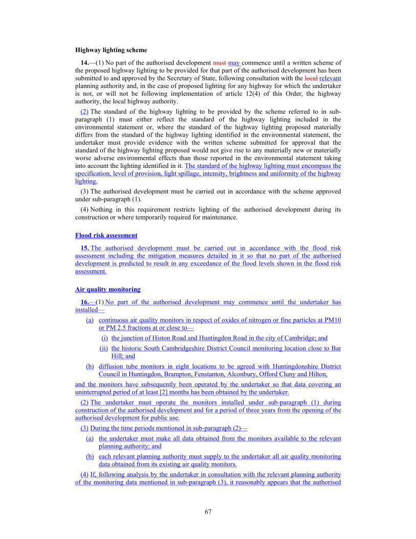
67
Highway lighting scheme
14.—(1) No part of the authorised development must may commence until a written scheme of
the proposed highway lighting to be provided for that part of the authorised development has been
submitted to and approved by the Secretary of State, following consultation with the local relevant
planning authority and, in the case of proposed lighting for any highway for which the undertaker
is not, or will not be following implementation of article 12(4) of this Order, the highway
authority, the local highway authority.
(2) The standard of the highway lighting to be provided by the scheme referred to in sub-
paragraph (1) must either reflect the standard of the highway lighting included in the
environmental statement or, where the standard of the highway lighting proposed materially
differs from the standard of the highway lighting identified in the environmental statement, the
undertaker must provide evidence with the written scheme submitted for approval that the
standard of the highway lighting proposed would not give rise to any materially new or materially
worse adverse environmental effects than those reported in the environmental statement taking
into account the lighting identified in it. The standard of the highway lighting must encompass the
specification, level of provision, light spillage, intensity, brightness and uniformity of the highway
lighting.
(3) The authorised development must be carried out in accordance with the scheme approved
under sub-paragraph (1).
(4) Nothing in this requirement restricts lighting of the authorised development during its
construction or where temporarily required for maintenance.
Flood risk assessment
15. The authorised development must be carried out in accordance with the flood risk
assessment including the mitigation measures detailed in it so that no part of the authorised
development is predicted to result in any exceedance of the flood levels shown in the flood risk
assessment.
Air quality monitoring
16.—(1) No part of the authorised development may commence until the undertaker has
installed—
(a) continuous air quality monitors in respect of oxides of nitrogen or fine particles at PM10
or PM 2.5 fractions at or close to—
(i) the junction of Histon Road and Huntingdon Road in the city of Cambridge; and
(ii) the historic South Cambridgeshire District Council monitoring location close to Bar
Hill; and
(b) diffusion tube monitors in eight locations to be agreed with Huntingdonshire District
Council in Huntingdon, Brampton, Fenstanton, Alconbury, Offord Cluny and Hilton,
and the monitors have subsequently been operated by the undertaker so that data covering an
uninterrupted period of at least [2] months has been obtained by the undertaker.
(2) The undertaker must operate the monitors installed under sub-paragraph (1) during
construction of the authorised development and for a period of three years from the opening of the
authorised development for public use.
(3) During the time periods mentioned in sub-paragraph (2)—
(a) the undertaker must make all data obtained from the monitors available to the relevant
planning authority; and
(b) each relevant planning authority must supply to the undertaker all air quality monitoring
data obtained from its existing air quality monitors.
(4) If, following analysis by the undertaker in consultation with the relevant planning authority
of the monitoring data mentioned in sub-paragraph (3), it reasonably appears that the authorised

68
development has materially worsened air quality and there is a material risk of exceedance of air
quality objectives at the sites mentioned in sub-paragraph (1), the undertaker will discuss with the
relevant planning authority the provision of a scheme of mitigation which the undertaker must
submit to the Secretary of State for approval.
(5) Before considering whether to approve the scheme of mitigation, the Secretary of State must
consult the relevant planning authority.
(6) The scheme of mitigation approved under sub-paragraph (4) must be implemented by the
undertaker.
Development of detailed design
17.15.—15.—(1) No part of the authorised development may commence until options for the
detailed design of that part of the authorised development have been submitted to the Design
Council’s Design Review panel and the undertaker has received and considered the advice of the
Design Council’s Design Review panel in respect of the detailed design of that part of the
authorised development.
(2) The undertaker must, in the course of developing the detailed design of the authorised
development, consult with the relevant planning authorities, the Parish Forums, the Community
Forums, the Landowner Forums and the Environment Forum in accordance with the provisions of
the code of construction practice.
(3) No part of the authorised development may commence until details of the external
appearance of the viaduct to be constructed as Work No. 5(gg) have been submitted to and
approved by the Secretary of State, following consultation with the relevant planning authority.
Amendments to approved details
18.16. With respect to any requirement which requires the authorised development to be carried
out in accordance with the details approved under this Schedule, the approved details are taken to
include any amendments that may subsequently be approved in writing.
Details of consultation
19. —(1) With respect to any requirement which requires details to be submitted to the Secretary
of State for approval under this Schedule, the details submitted must be accompanied by a
summary report setting out the consultation undertaken by the undertaker to inform the details
submitted and the undertaker’s response to that consultation.
(2) The undertaker must ensure that any consultation responses are reflected in the details
submitted to the Secretary of State for approval under this Schedule, but only where it is
appropriate, reasonable and feasible to do so, taking into account considerations including, but not
limited to, cost and engineering practicality.
PART 2
PROCEDURE FOR DISCHARGE OF REQUIREMENTS
Applications made under requirements
20.18.—18.—(1) Where an application has been made to the Secretary of State for any consent,
agreement or approval required by a requirement (including agreement or approval in respect of
part of a requirement) included in this Order the Secretary of State must give notice to the
undertaker of his or her decision on the application within a period of 8 weeks beginning with—
(a) the day immediately following that on which the application is received by the Secretary
of State;

69
(b) the day immediately following that on which further information has been supplied by the
undertaker under paragraph 1921; or
(c) such longer period as may be agreed between the parties.
(2) Subject to sub-paragraph (3), in the event that the Secretary of State does not determine an
application within the period set out in sub-paragraph (1), the Secretary of State is taken to have
granted all parts of the application (without any condition or qualification) at the end of that
period.
(3) Where—
(a) an application has been made to the Secretary of State for any consent, agreement or
approval required by a requirement included in this Order;and
(b) the Secretary of State does not determine such application within the period set out in
sub-paragraph (1); and
(c) the application is accompanied by a report that considers it likely that the subject matter
of the application is to give rise to any materially new or materially worse environmental
effects in comparison with the authorised development as approved,
then the application is taken to have been refused by the Secretary of State at the end of that
period.
Further information
21.19.—19.—(1) In relation to any part of an application made under this Schedule, the
Secretary of State has the right to request such further information from the undertaker as is
necessary to enable the Secretary of State to consider the application.
(2) In the event that the Secretary of State considers such further information to be necessary the
Secretary of State must, within 21 business days of receipt of the application, notify the undertaker
in writing specifying the further information required and (if applicable) to which part of the
application it relates. In the event that the Secretary of State does not give such notification within
this 21 day period the Secretary of State is deemed to have sufficient information to consider the
application and is not thereafter entitled to request further information without the prior agreement
of the undertaker.
(3) Where further information is requested under this paragraph 19 21 in relation to part only of
an application, that part is treated as separate from the remainder of the application for the
purposes of calculating the time periods referred to in paragraph 18 20 and in this paragraph.
Register of requirements
22.20.—20.—(1) The undertaker must, as soon as practicable following the making of this
Order, establish and maintain in an electronic form suitable for inspection by members of the
public a register of those requirements contained in Part 1 of this Schedule that provide for further
approvals to be given by the Secretary of State.
(2) The register must set out in relation to each such requirement the status of the requirement,
in terms of whether any approval to be given by the Secretary of State has been applied for or
given, providing an electronic link to any document containing any approved details.
(3) The register must be maintained by the undertaker for a period of 3 years following
completion of the authorised development.
Anticipatory steps towards compliance with any requirement
23. If before this Order came into force the undertaker or any other person took any steps that
were intended to be steps towards compliance with any provision of Part 1 of this Schedule, those
steps may be taken into account for the purpose of determining compliance with that provision if
they would have been valid steps for that purpose had they been taken after this Order came into
force.

70
SCHEDULE 3 Articles 12 and 16
CLASSIFICATION OF ROADS, ETC
Note 1: the naming conventions used in this Schedule to describe roads, junctions and structures
relate to the naming conventions used in the labels on the traffic regulation measures plans.
PART 1
SPEED LIMITS
Note 2: where speed limits are indicated on the plans relating to this schedule (the traffic
regulation measures plans - speed limits and prohibitions) but are not referenced in this schedule
they indicate that national speed limits apply in accordance with the provisions of the Road Traffic
Regulation Act 1984 (which defines speed limits on ‘restricted roads’ by reference to street
lighting) and are not subject to this order. For details of the scheme lighting design, please refer to
the general arrangement drawings.
Parish(es)
(1)
Road name, number and length
(2)
Speed Limit
(3)
The traffic regulation measures (speed limits and prohibitions) plans - sheet 4
Brampton A14 Trunk Road New Ellington Junction
to Brampton Hut Junction
From the centre point of the Northern
New Ellington Roundabout eastwards for
distance of 388 metres along the new
alignment of the A14 Trunk Road.
For extent of lighting design, please refer
to general arrangement drawings, sheet 3.
Removal of restricted
road status
70mph speed limit to be
imposed70 miles per
hour
A14 Trunk Road Eastbound Diverge Slip
onto the Northern New Ellington
Roundabout
From its junction with the Northern New
Ellington Roundabout for a distance of
157 metres in a westerly direction.
For extent of lighting design, please refer
to general arrangement drawings, sheet3.
Removal of restricted
road
70mph speed limit to be
imposed70 miles per
hour

71
Parish(es)
(1)
Road name, number and length
(2)
Speed Limit
(3)
A14 Trunk Road Westbound Merge Slip
from the Southern New Ellington
Roundabout
From its junction with the Southern New
Ellington Roundabout for a distance of
162 metres in a north westerly direction.
For extent of lighting design, please refer
to general arrangement drawings, sheet 3.
Removal of restricted
road status
70mph speed limit to be
imposed70 miles per
hour
A14 Trunk Road connecting the Northern
and Southern New Ellington Roundabouts
From the centre point of the Northern
New Ellington Roundabout for a distance
of 49 metres along the carriageway (plus
the circumference of the Northern New
Ellington Roundabout) in a south westerly
direction.
From the centre point of the Southern
New Ellington Roundabout for distance of
52 metres along the carriageway (plus the
circumference of the Southern New
Ellington Roundabout) in a north easterly
direction.
For extent of lighting design, please refer
to general arrangement drawings, sheet 3.
Removal of restricted
road status
70mph speed limit to be
imposed70 miles per
hour
Woolley Road
From the centre point of the Northern
New Ellington Roundabout for a distance
of 96 metres in a generally north westerly
direction along the Woolley Road.
For extent of lighting design, please refer
to general arrangement drawings, sheet 3.
Removal of restricted
road status
60mph speed limit to be
imposed60 miles per
hour
Parish(es)
(1)
Road name, number and length
(2)
Speed Limit
(3)
The traffic regulation measures (speed limits and prohibitions) plans - sheets 5 and 6
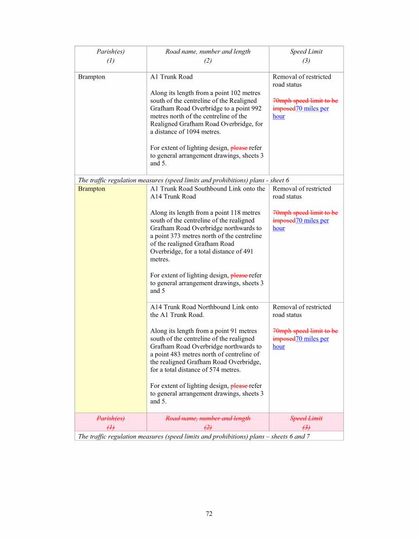
72
Parish(es)
(1)
Road name, number and length
(2)
Speed Limit
(3)
Brampton A1 Trunk Road
Along its length from a point 102 metres
south of the centreline of the Realigned
Grafham Road Overbridge to a point 992
metres north of the centreline of the
Realigned Grafham Road Overbridge, for
a distance of 1094 metres.
For extent of lighting design, please refer
to general arrangement drawings, sheets 3
and 5.
Removal of restricted
road status
70mph speed limit to be
imposed70 miles per
hour
The traffic regulation measures (speed limits and prohibitions) plans - sheet 6
Brampton A1 Trunk Road Southbound Link onto the
A14 Trunk Road
Along its length from a point 118 metres
south of the centreline of the realigned
Grafham Road Overbridge northwards to
a point 373 metres north of the centreline
of the realigned Grafham Road
Overbridge, for a total distance of 491
metres.
For extent of lighting design, please refer
to general arrangement drawings, sheets 3
and 5
Removal of restricted
road status
70mph speed limit to be
imposed70 miles per
hour
A14 Trunk Road Northbound Link onto
the A1 Trunk Road.
Along its length from a point 91 metres
south of the centreline of the realigned
Grafham Road Overbridge northwards to
a point 483 metres north of centreline of
the realigned Grafham Road Overbridge,
for a total distance of 574 metres.
For extent of lighting design, please refer
to general arrangement drawings, sheets 3
and 5.
Removal of restricted
road status
70mph speed limit to be
imposed70 miles per
hour
Parish(es)
(1)
Road name, number and length
(2)
Speed Limit
(3)
The traffic regulation measures (speed limits and prohibitions) plans – sheets 6 and 7

73
Parish(es)
(1)
Road name, number and length
(2)
Speed Limit
(3)
Brampton, Buckden A14 Trunk Road
Along its length from a point 550 metres
southeast of the centreline of the realigned
B1514 Buckden Road north-westwards to
a point 165 metres from the centreline of
the realigned B1514 Buckden Road, for a
total distance of 715 metres.
For extent of lighting design, please refer
to general arrangement drawings, sheets 5
and 6.
Removal of restricted
road status
70mph speed limit to be
imposed70 miles per
hour
Brampton A1 Trunk Road
Along its length of the southbound
carriageway from the point of
commencement of the existing 50mph
speed limit 15 metres north of the
centreline of the B1514 Buckden Road
Underbridge to a point 215 metres north
of the centreline of the B1514 Buckden
Road Underbridge, for a distance of 200
metres.
For extent of lighting design, please refer
to general arrangement drawings, sheets 5
and 6.
Removal of restricted
road status
50mph speed limit to be
imposed50 miles per
hour
The traffic regulation measures (speed limits and prohibitions) plans - sheet 7
Brampton, Buckden A1 Trunk Road Southbound Link onto the
A14 Trunk Road
Along its length from a point 91 metres
northwest of the centreline of the
realigned B1514 Buckden Road south-
eastwards to a point 529 metres from the
centreline of the B1514 Buckden Road,
for a total distance of 620 metres.
For extent of lighting design, please refer
to general arrangement drawings, sheet 6.
Removal of restricted
road status
70mph speed limit to be
imposed70 miles per
hour
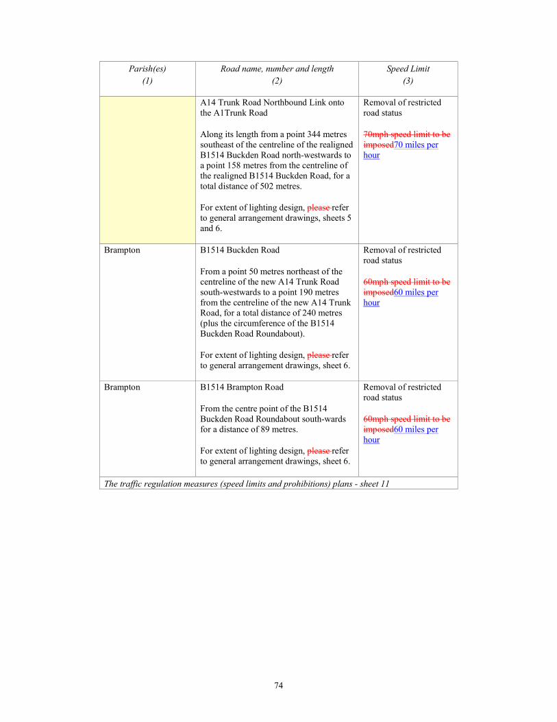
74
Parish(es)
(1)
Road name, number and length
(2)
Speed Limit
(3)
A14 Trunk Road Northbound Link onto
the A1Trunk Road
Along its length from a point 344 metres
southeast of the centreline of the realigned
B1514 Buckden Road north-westwards to
a point 158 metres from the centreline of
the realigned B1514 Buckden Road, for a
total distance of 502 metres.
For extent of lighting design, please refer
to general arrangement drawings, sheets 5
and 6.
Removal of restricted
road status
70mph speed limit to be
imposed70 miles per
hour
Brampton B1514 Buckden Road
From a point 50 metres northeast of the
centreline of the new A14 Trunk Road
south-westwards to a point 190 metres
from the centreline of the new A14 Trunk
Road, for a total distance of 240 metres
(plus the circumference of the B1514
Buckden Road Roundabout).
For extent of lighting design, please refer
to general arrangement drawings, sheet 6.
Removal of restricted
road status
60mph speed limit to be
imposed60 miles per
hour
Brampton B1514 Brampton Road
From the centre point of the B1514
Buckden Road Roundabout south-wards
for a distance of 89 metres.
For extent of lighting design, please refer
to general arrangement drawings, sheet 6.
Removal of restricted
road status
60mph speed limit to be
imposed60 miles per
hour
The traffic regulation measures (speed limits and prohibitions) plans - sheet 11

75
Parish(es)
(1)
Road name, number and length
(2)
Speed Limit
(3)
Hemingford Abbots A1198 Ermine Street
From a point 92 metres north-westwards
from the centre point of the Northern
Ermine Street Roundabout south-
eastwards to a point 61 metres from the
centre point of the Northern Ermine Street
Roundabout, for a total distance of 153
metres (plus the circumference of the
Northern Ermine Street Roundabout).
For extent of lighting design, please refer
to general arrangement drawings, sheet 9.
From a point 65 metres north-westwards
from the centre point of the Southern
Ermine Street Roundabout southwards to
a point 70 metres from the centre point of
the Southern Ermine Street Roundabout,
for a total distance of 135 metres (plus the
circumference of the Southern Ermine
Street Roundabout).
For extent of lighting design, please refer
to general arrangement drawings, sheet 9.
Removal of restricted
road status
60mph speed limit to be
imposed60 miles per
hour
A14 Trunk Road Eastbound Diverge Slip
onto the Northern Ermine Street
Roundabout
From its junction with the Northern
Ermine Street Roundabout for a distance
of 161 metres in a westerly direction.
For extent of lighting design, please refer
to general arrangement drawings, sheet 9.
Removal of restricted
road status
70mph speed limit to be
imposed70 miles per
hour
A14 Trunk Road Westbound Merge Slip
from the Southern Ermine Street
Roundabout
From its junction with the Southern
Ermine Street Roundabout for a distance
of 161 metres in a north westerly
direction.
For extent of lighting design, please refer
to general arrangement drawings, sheet 9.
Removal of restricted
road status
70mph speed limit to be
imposed70 miles per
hour
The traffic regulation measures (speed limits and prohibitions) plans - sheet 17

76
Parish(es)
(1)
Road name, number and length
(2)
Speed Limit
(3)
Swavesey A1307
From the centre point of the Northern
Swavesey Roundabout westwards for a
distance of 113.
For extent of lighting design, please refer
to general arrangement drawings, sheet
15.
Removal of restricted
road status
70mph speed limit to be
imposed70 miles per
hour
Swavesey Link Road between Northern
Swavesey Roundabout and Bucking Way
Road Roundabout (A1307 formerly the
A14(T))
From its junction with the Northern
Swavesey Roundabout to its junction with
Bucking Way Roundabout (plus the
circumference of the Northern Swavesey
Roundabout and the circumference of
Bucking Way Roundabout).
For extent of lighting design, please refer
to general arrangement drawings, sheet
15.
Removal of restricted
road status
60mph speed limit to be
imposed60 miles per
hour
Bucking Way Road
From the centre point of the Bucking Way
Road Roundabout north-eastwards for a
distance of 92 metres.
For extent of lighting design, please refer
to general arrangement drawings, sheet
15.
Removal of restricted
road status
60mph speed limit to be
imposed60 miles per
hour
Local Access Road (A1307 formerly the
A14(T))
From the centre point of the Bucking Way
Road Roundabout generally south-
eastwards for a distance of 96 metres.
For extent of lighting design, please refer
to general arrangement drawings, sheet
15.
Removal of restricted
road status
60mph speed limit to be
imposed60 miles per
hour

77
Parish(es)
(1)
Road name, number and length
(2)
Speed Limit
(3)
Swavesey, Boxworth
A14 Trunk Road Eastbound Diverge Slip
onto the Northern Swavesey Roundabout
From the centre point of the Northern
Swavesey Roundabout south-eastwards
then south-westwards for a distance of
304 metres.
For extent of lighting design, please refer
to general arrangement drawings, sheet
15.
Removal of restricted
road status
70mph speed limit to be
imposed70 miles per
hour
Swavesey Link Road
From the centre point of the Northern
Swavesey Roundabout for a distance of 93
metres in a south-westerly direction.
For extent of lighting design, please refer
to general arrangement drawings, sheet
15.
From the centre point of the Southern
Swavesey Roundabout for a distance of 56
metres (plus the circumference of the
Southern Swavesey Roundabout) in a
north easterly direction.
For extent of lighting design, please refer
to general arrangement drawings, sheet
15.
Removal of restricted
road status
70mph speed limit to be
imposed70 miles per
hour
Boxworth A14 Trunk Road Westbound
Merge Slip from Southern Swavesey
Roundabout onto the Westbound A14
Trunk Road
From its junction with the Southern
Swavesey Roundabout for a distance of
158 metres in a north-westerly direction.
For extent of lighting design, please refer
to general arrangement drawings, sheet
15.
Removal of restricted
road status
70mph speed limit to be
imposed70 miles per
hour
The traffic regulation measures (speed limits and prohibitions) plans - sheet 17 and18
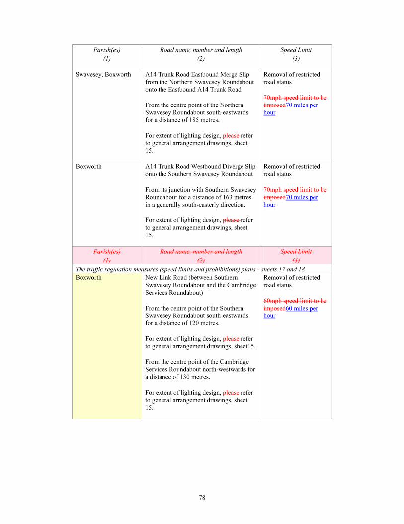
78
Parish(es)
(1)
Road name, number and length
(2)
Speed Limit
(3)
Swavesey, Boxworth
A14 Trunk Road Eastbound Merge Slip
from the Northern Swavesey Roundabout
onto the Eastbound A14 Trunk Road
From the centre point of the Northern
Swavesey Roundabout south-eastwards
for a distance of 185 metres.
For extent of lighting design, please refer
to general arrangement drawings, sheet
15.
Removal of restricted
road status
70mph speed limit to be
imposed70 miles per
hour
Boxworth A14 Trunk Road Westbound Diverge Slip
onto the Southern Swavesey Roundabout
From its junction with Southern Swavesey
Roundabout for a distance of 163 metres
in a generally south-easterly direction.
For extent of lighting design, please refer
to general arrangement drawings, sheet
15.
Removal of restricted
road status
70mph speed limit to be
imposed70 miles per
hour
Parish(es)
(1)
Road name, number and length
(2)
Speed Limit
(3)
The traffic regulation measures (speed limits and prohibitions) plans - sheets 17 and 18
Boxworth New Link Road (between Southern
Swavesey Roundabout and the Cambridge
Services Roundabout)
From the centre point of the Southern
Swavesey Roundabout south-eastwards
for a distance of 120 metres.
For extent of lighting design, please refer
to general arrangement drawings, sheet15.
From the centre point of the Cambridge
Services Roundabout north-westwards for
a distance of 130 metres.
For extent of lighting design, please refer
to general arrangement drawings, sheet
15.
Removal of restricted
road status
60mph speed limit to be
imposed60 miles per
hour
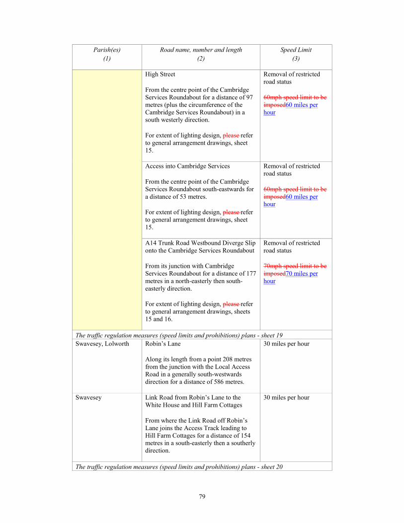
79
Parish(es)
(1)
Road name, number and length
(2)
Speed Limit
(3)
High Street
From the centre point of the Cambridge
Services Roundabout for a distance of 97
metres (plus the circumference of the
Cambridge Services Roundabout) in a
south westerly direction.
For extent of lighting design, please refer
to general arrangement drawings, sheet
15.
Removal of restricted
road status
60mph speed limit to be
imposed60 miles per
hour
Access into Cambridge Services
From the centre point of the Cambridge
Services Roundabout south-eastwards for
a distance of 53 metres.
For extent of lighting design, please refer
to general arrangement drawings, sheet
15.
Removal of restricted
road status
60mph speed limit to be
imposed60 miles per
hour
A14 Trunk Road Westbound Diverge Slip
onto the Cambridge Services Roundabout
From its junction with Cambridge
Services Roundabout for a distance of 177
metres in a north-easterly then south-
easterly direction.
For extent of lighting design, please refer
to general arrangement drawings, sheets
15 and 16.
Removal of restricted
road status
70mph speed limit to be
imposed70 miles per
hour
The traffic regulation measures (speed limits and prohibitions) plans - sheet 19
Swavesey, Lolworth Robin’s Lane
Along its length from a point 208 metres
from the junction with the Local Access
Road in a generally south-westwards
direction for a distance of 586 metres.
30 miles per hour
Swavesey Link Road from Robin’s Lane to the
White House and Hill Farm Cottages
From where the Link Road off Robin’s
Lane joins the Access Track leading to
Hill Farm Cottages for a distance of 154
metres in a south-easterly then a southerly
direction.
30 miles per hour
The traffic regulation measures (speed limits and prohibitions) plans - sheet 20

80
Parish(es)
(1)
Road name, number and length
(2)
Speed Limit
(3)
Longstanton New Local Access Road A1307
From a point 256 metres north-westwards
from the centreline of the junction of the
A1307and the B1050 Link Road
connecting the A1307 to the B1050 south-
eastwards to point 420 metres from the
centreline of the junction of the A1307
and the B1050 Link Road connecting the
A1307 to the B1050, for a total distance
of 676 metres.
40 miles per hour
B1050 Hattons Road
From where it joins the northern side of
the Bar Hill Junction Circulatory
Carriageway for a distance of 540 metres
in a north-easterly direction.
40 miles per hour
B1050 Link Road between B1050 Hattons
Road and the Local Access Road (A1307
formerly the A14 (T))
From its junction with B1050 Hattons
Road for a distance of 170 metres in a
south-easterly then south-westerly
direction to where it joins the Local
Access Road (A1307 formerly the A14
(T)).
40 miles per hour
A14 Trunk Road Eastbound Diverge Sip
onto Bar Hill Junction
From its junction with Bar Hill for a
distance of 155 metres in a north-westerly
direction.
For extent of lighting design, please refer
to general arrangement drawings, sheet
17.
Removal of restricted
road status
70mph speed limit to be
imposed70 miles per
hour
A14 Trunk Road Eastbound merge slip
from Bar Hill Junction onto A14 Trunk
Road
From its junction with Bar Hill for a
distance of 155 metres in a south-easterly
direction.
For extent of lighting design, please refer
to general arrangement drawings, sheet
17.
Removal of restricted
road status
70mph speed limit to be
imposed70 miles per
hour
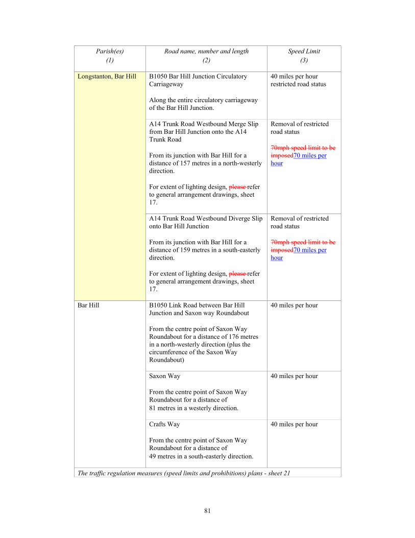
81
Parish(es)
(1)
Road name, number and length
(2)
Speed Limit
(3)
Longstanton, Bar Hill B1050 Bar Hill Junction Circulatory
Carriageway
Along the entire circulatory carriageway
of the Bar Hill Junction.
40 miles per hour
restricted road status
A14 Trunk Road Westbound Merge Slip
from Bar Hill Junction onto the A14
Trunk Road
From its junction with Bar Hill for a
distance of 157 metres in a north-westerly
direction.
For extent of lighting design, please refer
to general arrangement drawings, sheet
17.
Removal of restricted
road status
70mph speed limit to be
imposed70 miles per
hour
A14 Trunk Road Westbound Diverge Slip
onto Bar Hill Junction
From its junction with Bar Hill for a
distance of 159 metres in a south-easterly
direction.
For extent of lighting design, please refer
to general arrangement drawings, sheet
17.
Removal of restricted
road status
70mph speed limit to be
imposed70 miles per
hour
Bar Hill B1050 Link Road between Bar Hill
Junction and Saxon way Roundabout
From the centre point of Saxon Way
Roundabout for a distance of 176 metres
in a north-westerly direction (plus the
circumference of the Saxon Way
Roundabout)
40 miles per hour
Saxon Way
From the centre point of Saxon Way
Roundabout for a distance of
81 metres in a westerly direction.
40 miles per hour
Crafts Way
From the centre point of Saxon Way
Roundabout for a distance of
49 metres in a south-easterly direction.
40 miles per hour
The traffic regulation measures (speed limits and prohibitions) plans - sheet 21
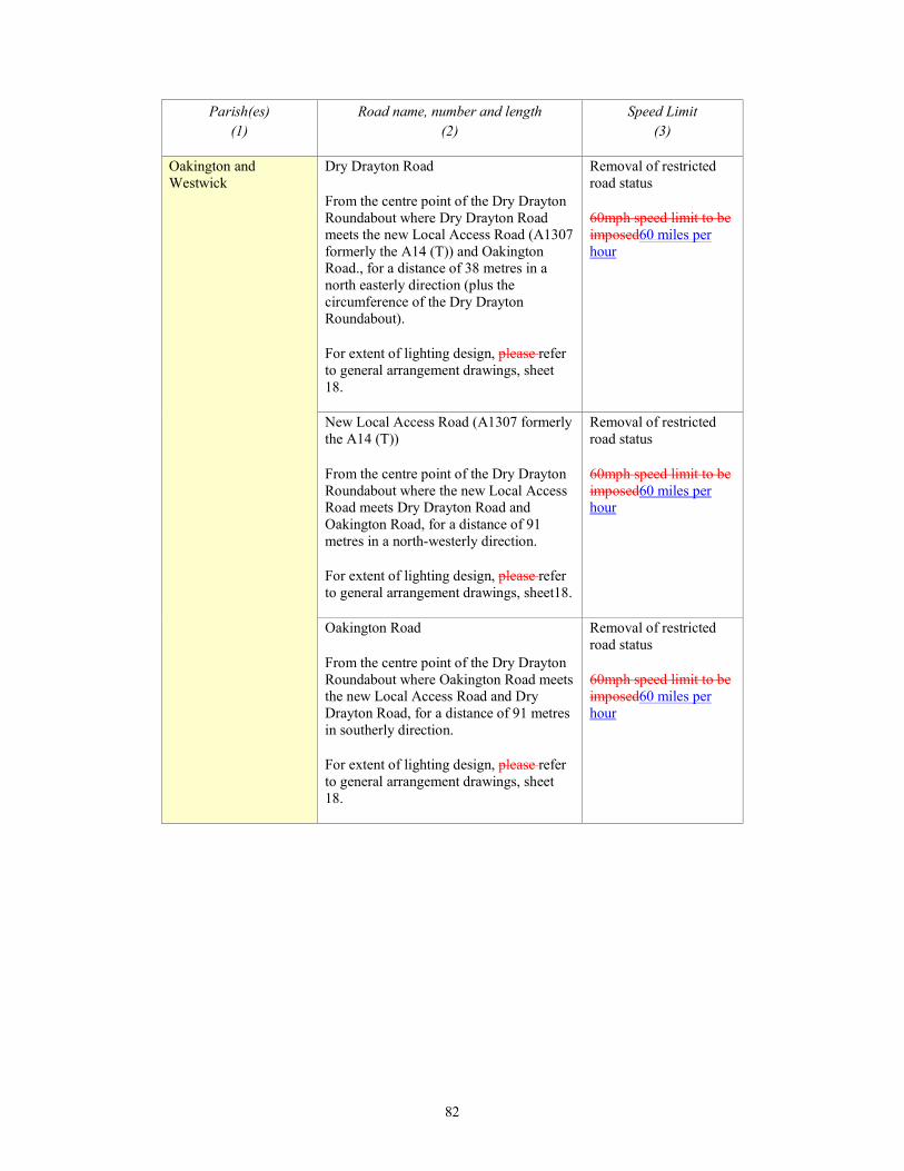
82
Parish(es)
(1)
Road name, number and length
(2)
Speed Limit
(3)
Oakington and
Westwick
Dry Drayton Road
From the centre point of the Dry Drayton
Roundabout where Dry Drayton Road
meets the new Local Access Road (A1307
formerly the A14 (T)) and Oakington
Road., for a distance of 38 metres in a
north easterly direction (plus the
circumference of the Dry Drayton
Roundabout).
For extent of lighting design, please refer
to general arrangement drawings, sheet
18.
Removal of restricted
road status
60mph speed limit to be
imposed60 miles per
hour
New Local Access Road (A1307 formerly
the A14 (T))
From the centre point of the Dry Drayton
Roundabout where the new Local Access
Road meets Dry Drayton Road and
Oakington Road, for a distance of 91
metres in a north-westerly direction.
For extent of lighting design, please refer
to general arrangement drawings, sheet18.
Removal of restricted
road status
60mph speed limit to be
imposed60 miles per
hour
Oakington Road
From the centre point of the Dry Drayton
Roundabout where Oakington Road meets
the new Local Access Road and Dry
Drayton Road, for a distance of 91 metres
in southerly direction.
For extent of lighting design, please refer
to general arrangement drawings, sheet
18.
Removal of restricted
road status
60mph speed limit to be
imposed60 miles per
hour

83
Parish(es)
(1)
Road name, number and length
(2)
Speed Limit
(3)
Dry Drayton Oakington Road
From the centre point of the Oakington
Road Roundabout where Oakington Road
meets the new Local Access Road (A1307
formerly the A14 (T)), for a distance of 82
metres in a north-easterly direction and 90
metres in a south-westerly direction, for a
total distance of 172 metres (plus the
circumference of the Oakington Road
Roundabout).
For extent of lighting design, please refer
to general arrangement drawings, sheet
18.
Removal of restricted
road status
60mph speed limit to be
imposed60 miles per
hour
New Local Access Road (A1307 formerly
the A14 (T))
From the centre point of the Oakington
Road Roundabout where Oakington Road
meets the new Local Access Road, for a
distance of 90 metres in south-easterly
direction.
For extent of lighting design, please refer
to general arrangement drawings, sheet
18.
Removal of restricted
road status
60mph speed limit to be
imposed60 miles per
hour
Crematorium Access Road
From its junction with the new Local
Access Road (A1307 formerly the A14
(T)), for a distance of 456 metres in a
generally north-easterly direction.
30 miles per hour
The traffic regulation measures (speed limits and prohibitions) plans - sheets 21 and 22
Girton A14 Trunk Road
From a point 13 metres north west of
where the A14 Trunk Road joins the M11
north-westwards for a distance of 749
metres.
For extent of lighting design, please refer
to general arrangement drawings, sheet
20.
Removal of restricted
road status
70mph speed limit to be
imposed70 miles per
hour
The traffic regulation measures (speed limits and prohibitions) plans- sheets 22 and 23
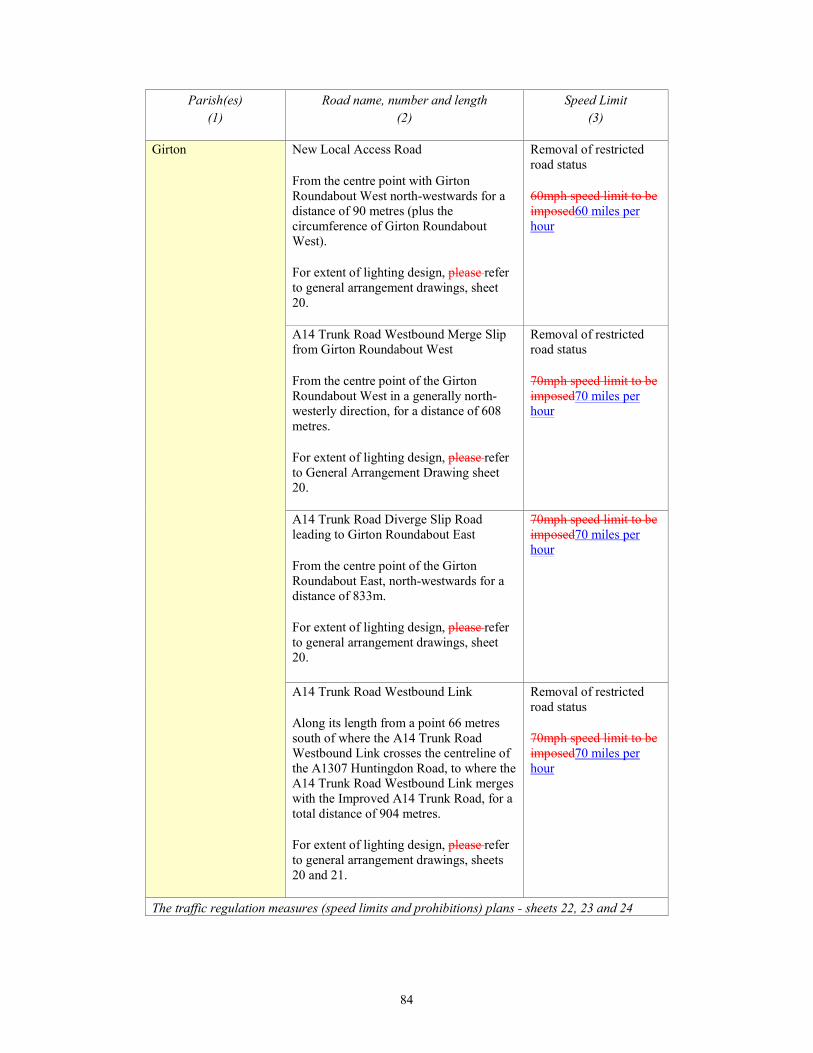
84
Parish(es)
(1)
Road name, number and length
(2)
Speed Limit
(3)
Girton New Local Access Road
From the centre point with Girton
Roundabout West north-westwards for a
distance of 90 metres (plus the
circumference of Girton Roundabout
West).
For extent of lighting design, please refer
to general arrangement drawings, sheet
20.
Removal of restricted
road status
60mph speed limit to be
imposed60 miles per
hour
A14 Trunk Road Westbound Merge Slip
from Girton Roundabout West
From the centre point of the Girton
Roundabout West in a generally north-
westerly direction, for a distance of 608
metres.
For extent of lighting design, please refer
to General Arrangement Drawing sheet
20.
Removal of restricted
road status
70mph speed limit to be
imposed70 miles per
hour
A14 Trunk Road Diverge Slip Road
leading to Girton Roundabout East
From the centre point of the Girton
Roundabout East, north-westwards for a
distance of 833m.
For extent of lighting design, please refer
to general arrangement drawings, sheet
20.
70mph speed limit to be
imposed70 miles per
hour
A14 Trunk Road Westbound Link
Along its length from a point 66 metres
south of where the A14 Trunk Road
Westbound Link crosses the centreline of
the A1307 Huntingdon Road, to where the
A14 Trunk Road Westbound Link merges
with the Improved A14 Trunk Road, for a
total distance of 904 metres.
For extent of lighting design, please refer
to general arrangement drawings, sheets
20 and 21.
Removal of restricted
road status
70mph speed limit to be
imposed70 miles per
hour
The traffic regulation measures (speed limits and prohibitions) plans - sheets 22, 23 and 24
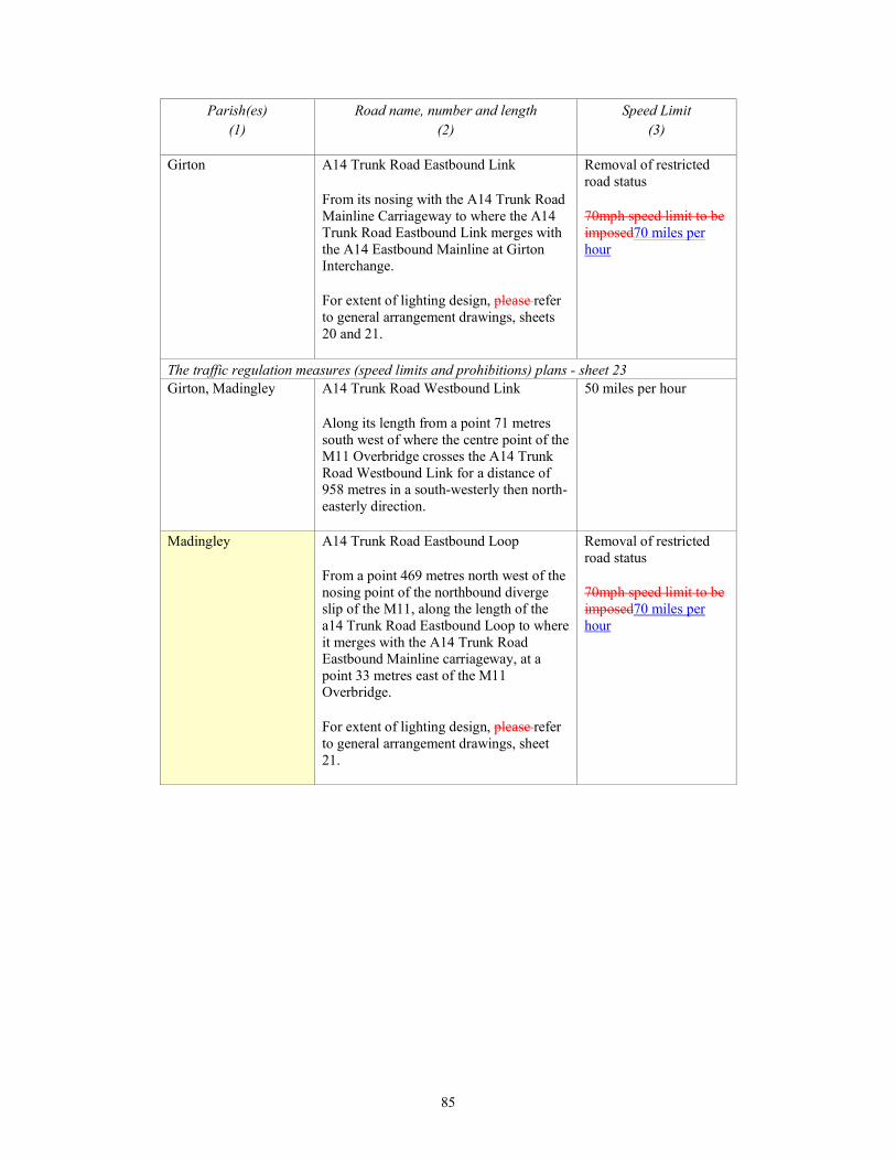
85
Parish(es)
(1)
Road name, number and length
(2)
Speed Limit
(3)
Girton A14 Trunk Road Eastbound Link
From its nosing with the A14 Trunk Road
Mainline Carriageway to where the A14
Trunk Road Eastbound Link merges with
the A14 Eastbound Mainline at Girton
Interchange.
For extent of lighting design, please refer
to general arrangement drawings, sheets
20 and 21.
Removal of restricted
road status
70mph speed limit to be
imposed70 miles per
hour
The traffic regulation measures (speed limits and prohibitions) plans - sheet 23
Girton, Madingley A14 Trunk Road Westbound Link
Along its length from a point 71 metres
south west of where the centre point of the
M11 Overbridge crosses the A14 Trunk
Road Westbound Link for a distance of
958 metres in a south-westerly then north-
easterly direction.
50 miles per hour
Madingley A14 Trunk Road Eastbound Loop
From a point 469 metres north west of the
nosing point of the northbound diverge
slip of the M11, along the length of the
a14 Trunk Road Eastbound Loop to where
it merges with the A14 Trunk Road
Eastbound Mainline carriageway, at a
point 33 metres east of the M11
Overbridge.
For extent of lighting design, please refer
to general arrangement drawings, sheet
21.
Removal of restricted
road status
70mph speed limit to be
imposed70 miles per
hour
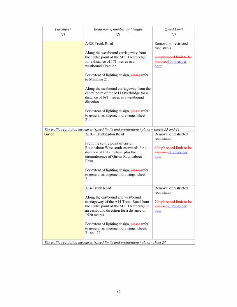
86
Parish(es)
(1)
Road name, number and length
(2)
Speed Limit
(3)
A428 Trunk Road
Along the westbound carriageway from
the centre point of the M11 Overbridge
for a distance of 171 metres in a
westbound direction.
For extent of lighting design, please refer
to Mainline 21.
Along the eastbound carriageway from the
centre point of the M11 Overbridge for a
distance of 691 metres in a westbound
direction.
For extent of lighting design, please refer
to general arrangement drawings, sheet
21.
Removal of restricted
road status
70mph speed limit to be
imposed70 miles per
hour
The traffic regulation measures (speed limits and prohibitions) plans – sheets 23 and 24
Girton A1037 Huntingdon Road
From the centre point of Girton
Roundabout West south-eastwards for a
distance of 1312 metres (plus the
circumference of Girton Roundabout
East).
For extent of lighting design, please refer
to general arrangement drawings, sheet
21.
Removal of restricted
road status
60mph speed limit to be
imposed 60 miles per
hour
A14 Trunk Road
Along the eastbound and westbound
carriageway of the A14 Trunk Road from
the centre point of the M11 Overbridge in
an eastbound direction for a distance of
1520 metres.
For extent of lighting design, please refer
to general arrangement drawings, sheets
21 and 22.
Removal of restricted
road status
70mph speed limit to be
imposed70 miles per
hour
The traffic regulation measures (speed limits and prohibitions) plans - sheet 24
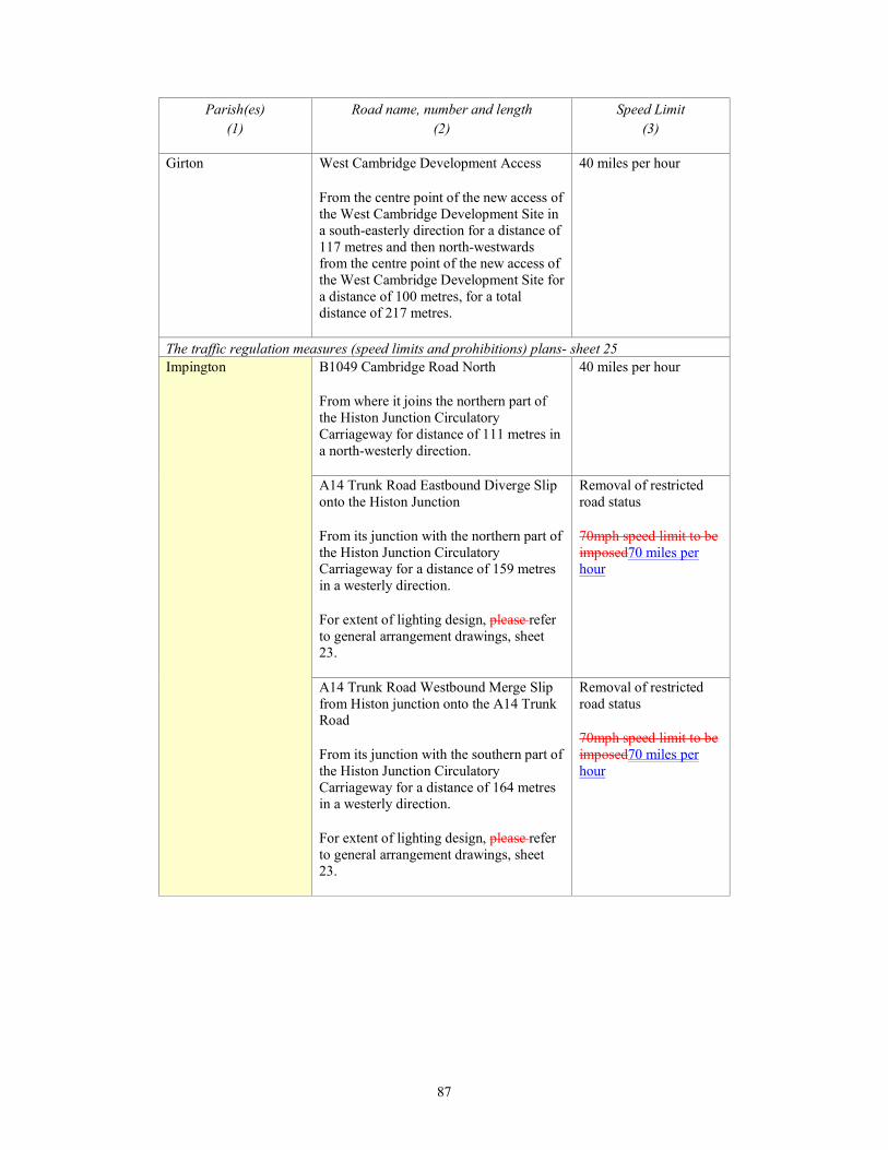
87
Parish(es)
(1)
Road name, number and length
(2)
Speed Limit
(3)
Girton West Cambridge Development Access
From the centre point of the new access of
the West Cambridge Development Site in
a south-easterly direction for a distance of
117 metres and then north-westwards
from the centre point of the new access of
the West Cambridge Development Site for
a distance of 100 metres, for a total
distance of 217 metres.
40 miles per hour
The traffic regulation measures (speed limits and prohibitions) plans- sheet 25
Impington B1049 Cambridge Road North
From where it joins the northern part of
the Histon Junction Circulatory
Carriageway for distance of 111 metres in
a north-westerly direction.
40 miles per hour
A14 Trunk Road Eastbound Diverge Slip
onto the Histon Junction
From its junction with the northern part of
the Histon Junction Circulatory
Carriageway for a distance of 159 metres
in a westerly direction.
For extent of lighting design, please refer
to general arrangement drawings, sheet
23.
Removal of restricted
road status
70mph speed limit to be
imposed70 miles per
hour
A14 Trunk Road Westbound Merge Slip
from Histon junction onto the A14 Trunk
Road
From its junction with the southern part of
the Histon Junction Circulatory
Carriageway for a distance of 164 metres
in a westerly direction.
For extent of lighting design, please refer
to general arrangement drawings, sheet
23.
Removal of restricted
road status
70mph speed limit to be
imposed70 miles per
hour

88
Parish(es)
(1)
Road name, number and length
(2)
Speed Limit
(3)
A14 Trunk Road Westbound Diverge Slip
onto Histon Junction
From a point 34 metres north-east of its
junction with the southern part of the
Histon Junction Circulatory Carriageway
for a distance of 161 metres in a north
easterly direction.
For extent of lighting design, please refer
to general arrangement drawings, sheet
23.
Removal of restricted
road status
70mph speed limit to be
imposed70 miles per
hour
A14 Trunk Road Eastbound Merge Slip
from Histon Junction onto the A14 Trunk
Road
From a point 9 metres north-west of its
junction with the northern part of the
Histon Junction Circulatory Carriageway
for a distance of 160 metres in a north
westerly direction.
For extent of lighting design, please refer
to general arrangement drawings, sheet
23.
Removal of restricted
road status
70mph speed limit to be
imposed70 miles per
hour
The traffic regulation measures (speed limits and prohibitions) plans - sheet 27
Milton A14 Trunk Road diverge slip road to the
A10 at Milton Junction
From the point of the nosing of the left
filter lane on the A14 diverge slip road at
Milton Junction for a distance of 208
metres in a northerly direction along the
A10.
50 miles per hour
Parish(es)
(1)
Road name, number and length
(2)
Speed Limit
(3)
The traffic regulation measures (speed limits and prohibitions) plans - sheet 28
Huntingdon A1307 (formerly A14(T))
From a point 96 metres north-westwards
from the centre of the new roundabout
junction located 475 metres north-east of
the Hinchingbrooke Park Road / Views
Common Link Signalised Junction for a
distance of 401 metres in a north-westerly
direction.
40 miles per hour
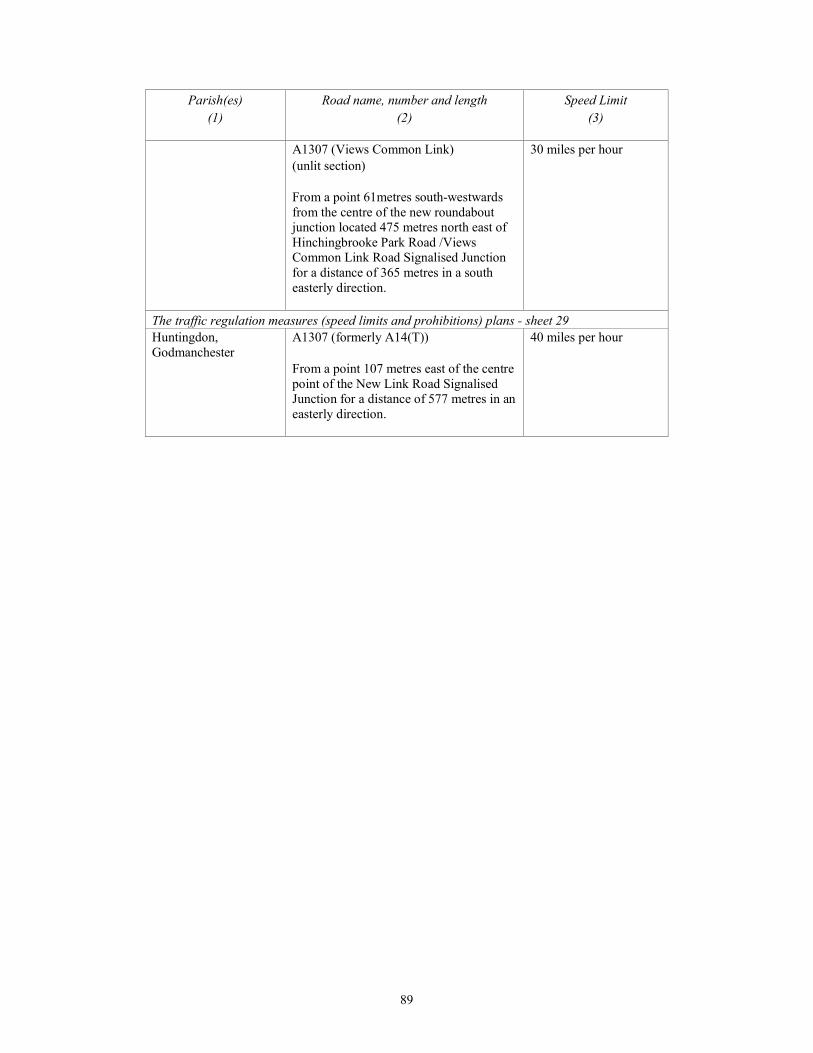
89
Parish(es)
(1)
Road name, number and length
(2)
Speed Limit
(3)
A1307 (Views Common Link)
(unlit section)
From a point 61metres south-westwards
from the centre of the new roundabout
junction located 475 metres north east of
Hinchingbrooke Park Road /Views
Common Link Road Signalised Junction
for a distance of 365 metres in a south
easterly direction.
30 miles per hour
The traffic regulation measures (speed limits and prohibitions) plans - sheet 29
Huntingdon,
Godmanchester
A1307 (formerly A14(T))
From a point 107 metres east of the centre
point of the New Link Road Signalised
Junction for a distance of 577 metres in an
easterly direction.
40 miles per hour
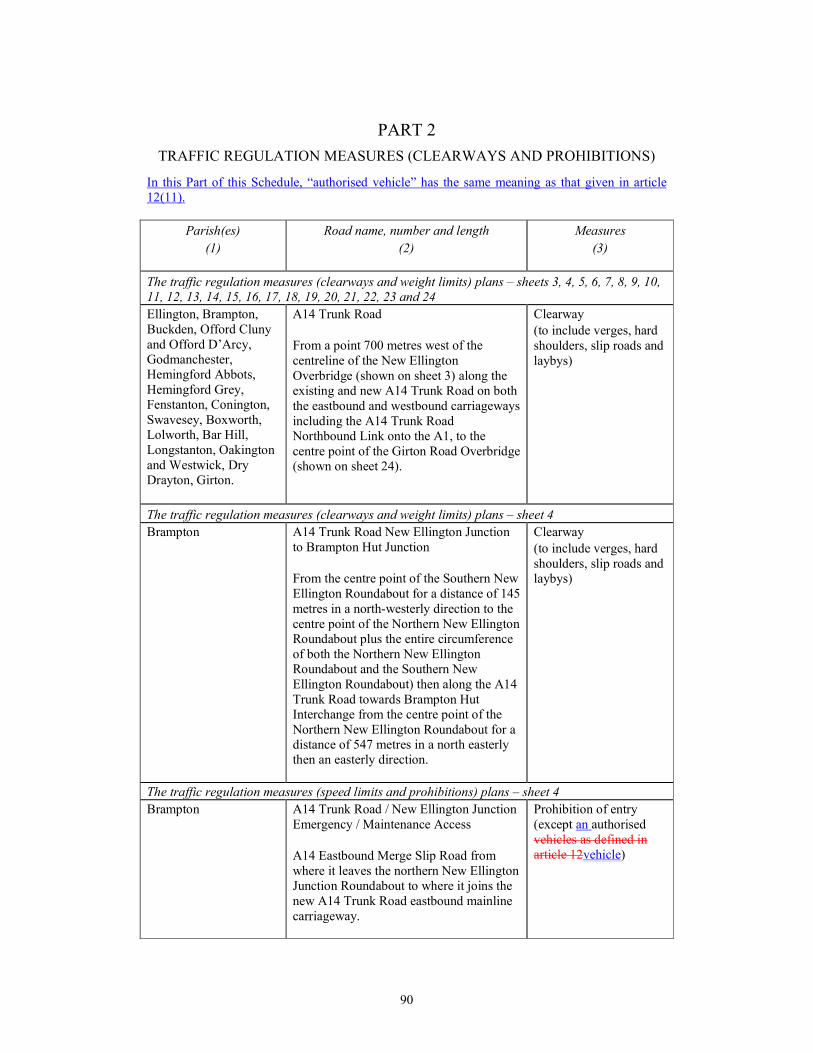
90
PART 2
TRAFFIC REGULATION MEASURES (CLEARWAYS AND PROHIBITIONS)
In this Part of this Schedule, “authorised vehicle” has the same meaning as that given in article
12(11).
Parish(es)
(1)
Road name, number and length
(2)
Measures
(3)
The traffic regulation measures (clearways and weight limits) plans – sheets 3, 4, 5, 6, 7, 8, 9, 10,
11, 12, 13, 14, 15, 16, 17, 18, 19, 20, 21, 22, 23 and 24
Ellington, Brampton,
Buckden, Offord Cluny
and Offord D’Arcy,
Godmanchester,
Hemingford Abbots,
Hemingford Grey,
Fenstanton, Conington,
Swavesey, Boxworth,
Lolworth, Bar Hill,
Longstanton, Oakington
and Westwick, Dry
Drayton, Girton.
A14 Trunk Road
From a point 700 metres west of the
centreline of the New Ellington
Overbridge (shown on sheet 3) along the
existing and new A14 Trunk Road on both
the eastbound and westbound carriageways
including the A14 Trunk Road
Northbound Link onto the A1, to the
centre point of the Girton Road Overbridge
(shown on sheet 24).
Clearway
(to include verges, hard
shoulders, slip roads and
laybys)
The traffic regulation measures (clearways and weight limits) plans – sheet 4
Brampton A14 Trunk Road New Ellington Junction
to Brampton Hut Junction
From the centre point of the Southern New
Ellington Roundabout for a distance of 145
metres in a north-westerly direction to the
centre point of the Northern New Ellington
Roundabout plus the entire circumference
of both the Northern New Ellington
Roundabout and the Southern New
Ellington Roundabout) then along the A14
Trunk Road towards Brampton Hut
Interchange from the centre point of the
Northern New Ellington Roundabout for a
distance of 547 metres in a north easterly
then an easterly direction.
Clearway
(to include verges, hard
shoulders, slip roads and
laybys)
The traffic regulation measures (speed limits and prohibitions) plans – sheet 4
Brampton A14 Trunk Road / New Ellington Junction
Emergency / Maintenance Access
A14 Eastbound Merge Slip Road from
where it leaves the northern New Ellington
Junction Roundabout to where it joins the
new A14 Trunk Road eastbound mainline
carriageway.
Prohibition of entry
(except an authorised
vehicles as defined in
article 12vehicle)

91
Parish(es)
(1)
Road name, number and length
(2)
Measures
(3)
Brampton A14 Trunk Road / New Ellington Junction
Emergency / Maintenance Access
A14 Westbound Diverge Slip Road from
where it leaves the new A14 Trunk Road
westbound mainline carriageway to where
the A14 Westbound Diverge Slip Road
joins the southern New Ellington Junction
Roundabout.
Prohibition of entry
(except an authorised
vehicles as defined in
article 12vehicle)
The traffic regulation measures (speed limits and prohibitions) plans – sheets 4, 5, 6, 7, 8, 9, 10,
11, 12, 13, 14, 15, 16, 17, 18, 19, 20, 21, 22 and 23
Brampton, Buckden,
Offord Cluny and Offord
D’Arcy, Godmanchester,
Hemingford Abbots,
Hemingford Grey,
Fenstanton, Conington,
Swavesey, Boxworth,
Lolworth, Bar Hill,
Longstanton, Oakington
and Westwick, Dry
Drayton, Girton
A14 Trunk Road
From a point 281 metres west of the
centreline of the New Ellington
Overbridge (shown on sheet 4) along the
existing and new A14 Trunk Road on both
the eastbound and westbound carriageways
to the point where the A14 Trunk Road
meets the M11 at the Girton Interchange
(shown on sheet 23).
Prohibition of
pedestrians
A14 Trunk Road
From a point 281 metres west of the
centreline of the New Ellington
Overbridge (shown on sheet 4) along the
existing and new A14 Trunk Road on both
the eastbound and westbound carriageways
to the point where the A14 Trunk Road
joins with the M11 at the Girton
Interchange (shown on sheet 23).
Prohibition of cyclists
A14 Trunk Road
From a point 281 metres west of the
centreline of the New Ellington
Overbridge (shown on sheet 4) along the
existing and new A14 Trunk Road on both
the eastbound and westbound carriageways
to the point where the A14 Trunk Road
joins with the M11 at the Girton
Interchange (shown on sheet 23).
Prohibition of ridden or
accompanied horses
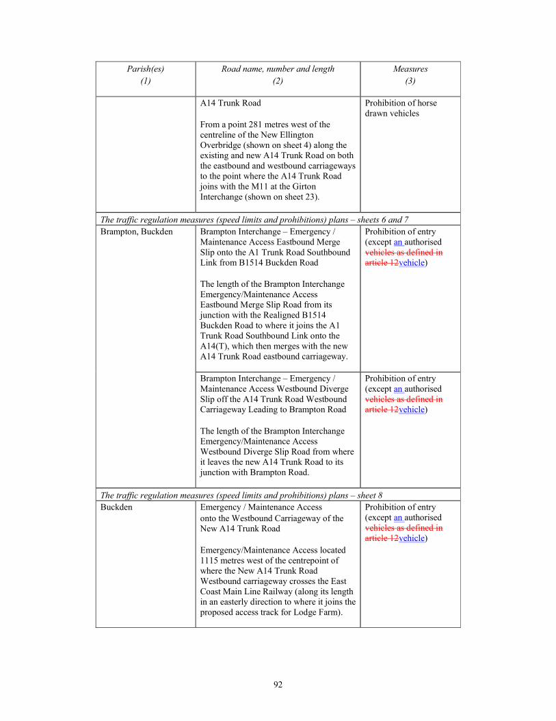
92
Parish(es)
(1)
Road name, number and length
(2)
Measures
(3)
A14 Trunk Road
From a point 281 metres west of the
centreline of the New Ellington
Overbridge (shown on sheet 4) along the
existing and new A14 Trunk Road on both
the eastbound and westbound carriageways
to the point where the A14 Trunk Road
joins with the M11 at the Girton
Interchange (shown on sheet 23).
Prohibition of horse
drawn vehicles
The traffic regulation measures (speed limits and prohibitions) plans – sheets 6 and 7
Brampton, Buckden Brampton Interchange – Emergency /
Maintenance Access Eastbound Merge
Slip onto the A1 Trunk Road Southbound
Link from B1514 Buckden Road
The length of the Brampton Interchange
Emergency/Maintenance Access
Eastbound Merge Slip Road from its
junction with the Realigned B1514
Buckden Road to where it joins the A1
Trunk Road Southbound Link onto the
A14(T), which then merges with the new
A14 Trunk Road eastbound carriageway.
Prohibition of entry
(except an authorised
vehicles as defined in
article 12vehicle)
Brampton Interchange – Emergency /
Maintenance Access Westbound Diverge
Slip off the A14 Trunk Road Westbound
Carriageway Leading to Brampton Road
The length of the Brampton Interchange
Emergency/Maintenance Access
Westbound Diverge Slip Road from where
it leaves the new A14 Trunk Road to its
junction with Brampton Road.
Prohibition of entry
(except an authorised
vehicles as defined in
article 12vehicle)
The traffic regulation measures (speed limits and prohibitions) plans – sheet 8
Buckden Emergency / Maintenance Access
onto the Westbound Carriageway of the
New A14 Trunk Road
Emergency/Maintenance Access located
1115 metres west of the centrepoint of
where the New A14 Trunk Road
Westbound carriageway crosses the East
Coast Main Line Railway (along its length
in an easterly direction to where it joins the
proposed access track for Lodge Farm).
Prohibition of entry
(except an authorised
vehicles as defined in
article 12vehicle)
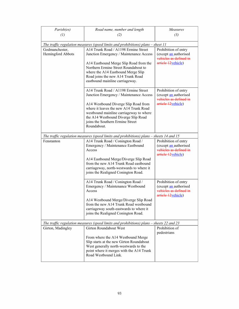
93
Parish(es)
(1)
Road name, number and length
(2)
Measures
(3)
The traffic regulation measures (speed limits and prohibitions) plans – sheet 11
Godmanchester,
Hemingford Abbots
A14 Trunk Road / A1198 Ermine Street
Junction Emergency / Maintenance Access
A14 Eastbound Merge Slip Road from the
Northern Ermine Street Roundabout to
where the A14 Eastbound Merge Slip
Road joins the new A14 Trunk Road
eastbound mainline carriageway.
Prohibition of entry
(except an authorised
vehicles as defined in
article 12vehicle)
A14 Trunk Road / A1198 Ermine Street
Junction Emergency / Maintenance Access
A14 Westbound Diverge Slip Road from
where it leaves the new A14 Trunk Road
westbound mainline carriageway to where
the A14 Westbound Diverge Slip Road
joins the Southern Ermine Street
Roundabout.
Prohibition of entry
(except an authorised
vehicles as defined in
article 12vehicle)
The traffic regulation measures (speed limits and prohibitions) plans – sheets 14 and 15
Fenstanton A14 Trunk Road / Conington Road /
Emergency / Maintenance Eastbound
Access
A14 Eastbound Merge/Diverge Slip Road
from the new A14 Trunk Road eastbound
carriageway, north-westwards to where it
joins the Realigned Conington Road.
Prohibition of entry
(except an authorised
vehicles as defined in
article 12vehicle)
A14 Trunk Road / Conington Road /
Emergency / Maintenance Westbound
Access
A14 Westbound Merge/Diverge Slip Road
from the new A14 Trunk Road westbound
carriageway south-eastwards to where it
joins the Realigned Conington Road.
Prohibition of entry
(except an authorised
vehicles as defined in
article 12vehicle)
The traffic regulation measures (speed limits and prohibitions) plans – sheets 22 and 23
Girton, Madingley Girton Roundabout West
From where the A14 Westbound Merge
Slip starts at the new Girton Roundabout
West generally north-westwards to the
point where it merges with the A14 Trunk
Road Westbound Link.
Prohibition of
pedestrians
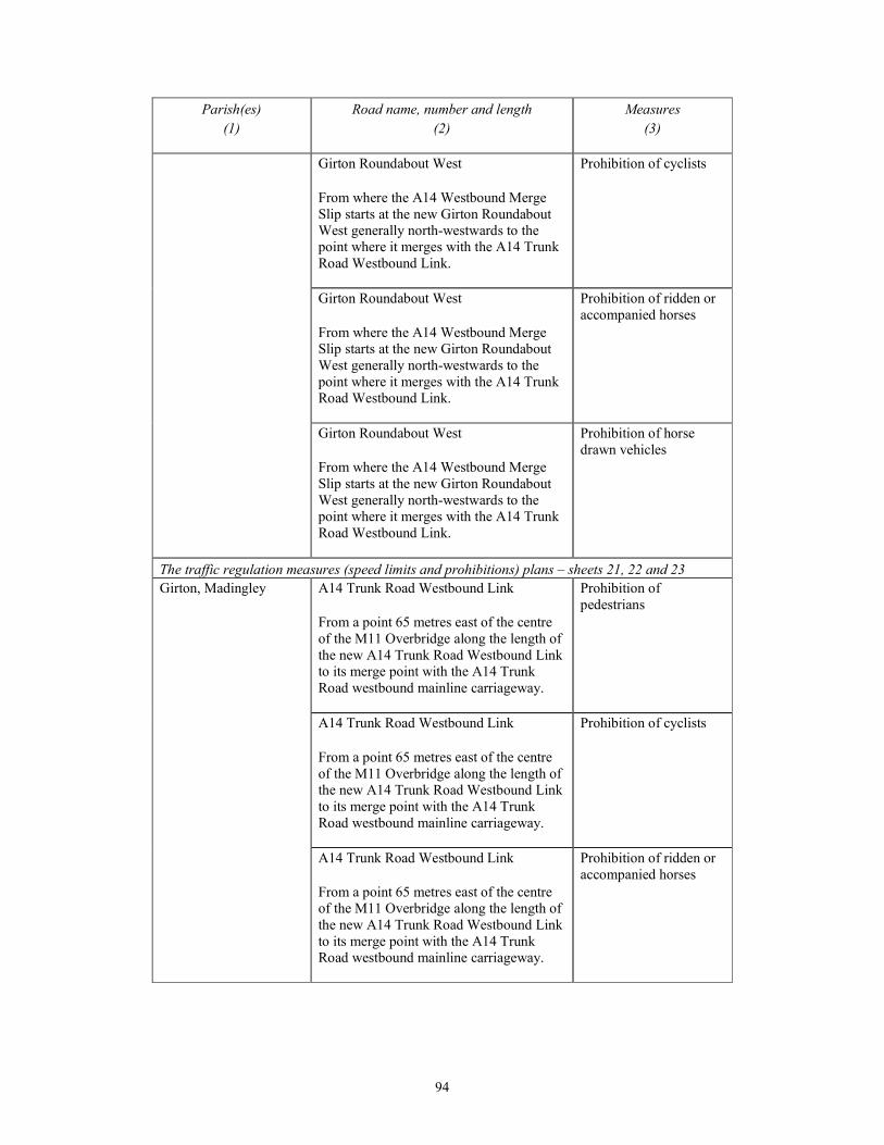
94
Parish(es)
(1)
Road name, number and length
(2)
Measures
(3)
Girton Roundabout West
From where the A14 Westbound Merge
Slip starts at the new Girton Roundabout
West generally north-westwards to the
point where it merges with the A14 Trunk
Road Westbound Link.
Prohibition of cyclists
Girton Roundabout West
From where the A14 Westbound Merge
Slip starts at the new Girton Roundabout
West generally north-westwards to the
point where it merges with the A14 Trunk
Road Westbound Link.
Prohibition of ridden or
accompanied horses
Girton Roundabout West
From where the A14 Westbound Merge
Slip starts at the new Girton Roundabout
West generally north-westwards to the
point where it merges with the A14 Trunk
Road Westbound Link.
Prohibition of horse
drawn vehicles
The traffic regulation measures (speed limits and prohibitions) plans – sheets 21, 22 and 23
Girton, Madingley A14 Trunk Road Westbound Link
From a point 65 metres east of the centre
of the M11 Overbridge along the length of
the new A14 Trunk Road Westbound Link
to its merge point with the A14 Trunk
Road westbound mainline carriageway.
Prohibition of
pedestrians
A14 Trunk Road Westbound Link
From a point 65 metres east of the centre
of the M11 Overbridge along the length of
the new A14 Trunk Road Westbound Link
to its merge point with the A14 Trunk
Road westbound mainline carriageway.
Prohibition of cyclists
A14 Trunk Road Westbound Link
From a point 65 metres east of the centre
of the M11 Overbridge along the length of
the new A14 Trunk Road Westbound Link
to its merge point with the A14 Trunk
Road westbound mainline carriageway.
Prohibition of ridden or
accompanied horses
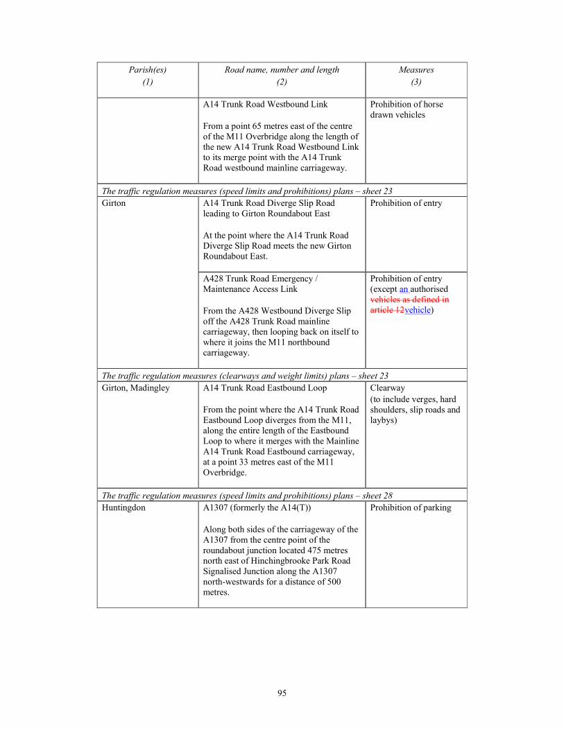
95
Parish(es)
(1)
Road name, number and length
(2)
Measures
(3)
A14 Trunk Road Westbound Link
From a point 65 metres east of the centre
of the M11 Overbridge along the length of
the new A14 Trunk Road Westbound Link
to its merge point with the A14 Trunk
Road westbound mainline carriageway.
Prohibition of horse
drawn vehicles
The traffic regulation measures (speed limits and prohibitions) plans – sheet 23
Girton A14 Trunk Road Diverge Slip Road
leading to Girton Roundabout East
At the point where the A14 Trunk Road
Diverge Slip Road meets the new Girton
Roundabout East.
Prohibition of entry
A428 Trunk Road Emergency /
Maintenance Access Link
From the A428 Westbound Diverge Slip
off the A428 Trunk Road mainline
carriageway, then looping back on itself to
where it joins the M11 northbound
carriageway.
Prohibition of entry
(except an authorised
vehicles as defined in
article 12vehicle)
The traffic regulation measures (clearways and weight limits) plans – sheet 23
Girton, Madingley A14 Trunk Road Eastbound Loop
From the point where the A14 Trunk Road
Eastbound Loop diverges from the M11,
along the entire length of the Eastbound
Loop to where it merges with the Mainline
A14 Trunk Road Eastbound carriageway,
at a point 33 metres east of the M11
Overbridge.
Clearway
(to include verges, hard
shoulders, slip roads and
laybys)
The traffic regulation measures (speed limits and prohibitions) plans – sheet 28
Huntingdon A1307 (formerly the A14(T))
Along both sides of the carriageway of the
A1307 from the centre point of the
roundabout junction located 475 metres
north east of Hinchingbrooke Park Road
Signalised Junction along the A1307
north-westwards for a distance of 500
metres.
Prohibition of parking
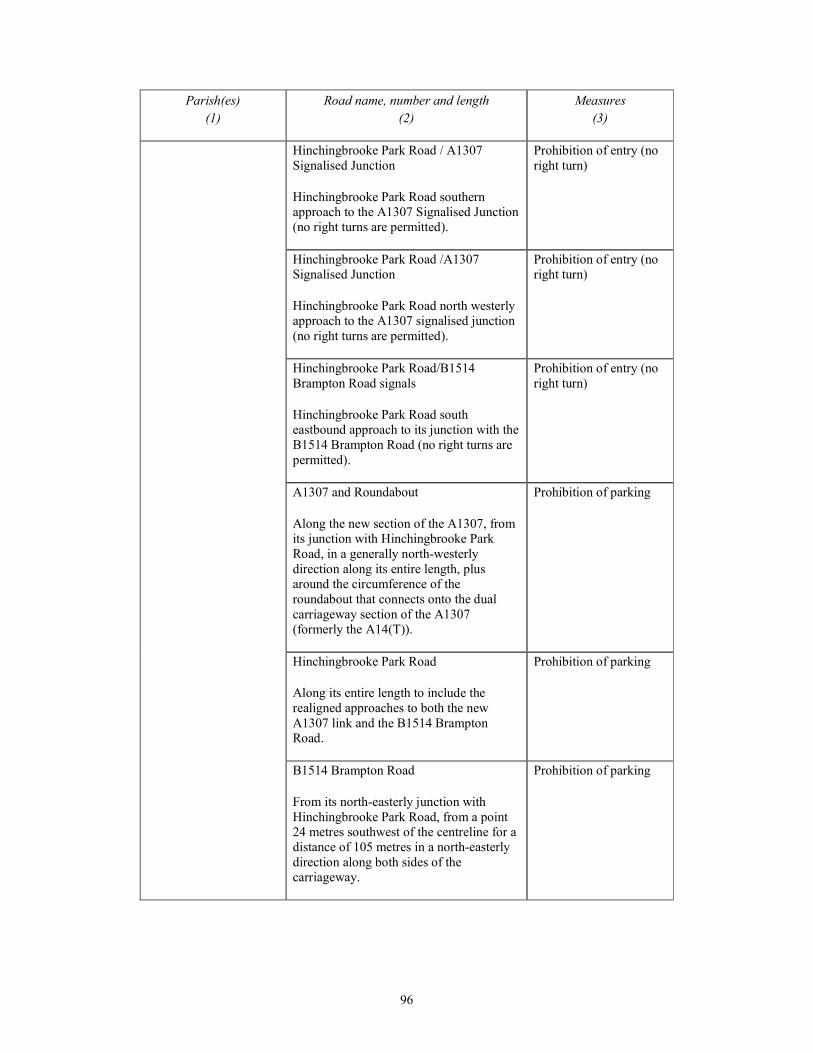
96
Parish(es)
(1)
Road name, number and length
(2)
Measures
(3)
Hinchingbrooke Park Road / A1307
Signalised Junction
Hinchingbrooke Park Road southern
approach to the A1307 Signalised Junction
(no right turns are permitted).
Prohibition of entry (no
right turn)
Hinchingbrooke Park Road /A1307
Signalised Junction
Hinchingbrooke Park Road north westerly
approach to the A1307 signalised junction
(no right turns are permitted).
Prohibition of entry (no
right turn)
Hinchingbrooke Park Road/B1514
Brampton Road signals
Hinchingbrooke Park Road south
eastbound approach to its junction with the
B1514 Brampton Road (no right turns are
permitted).
Prohibition of entry (no
right turn)
A1307 and Roundabout
Along the new section of the A1307, from
its junction with Hinchingbrooke Park
Road, in a generally north-westerly
direction along its entire length, plus
around the circumference of the
roundabout that connects onto the dual
carriageway section of the A1307
(formerly the A14(T)).
Prohibition of parking
Hinchingbrooke Park Road
Along its entire length to include the
realigned approaches to both the new
A1307 link and the B1514 Brampton
Road.
Prohibition of parking
B1514 Brampton Road
From its north-easterly junction with
Hinchingbrooke Park Road, from a point
24 metres southwest of the centreline for a
distance of 105 metres in a north-easterly
direction along both sides of the
carriageway.
Prohibition of parking
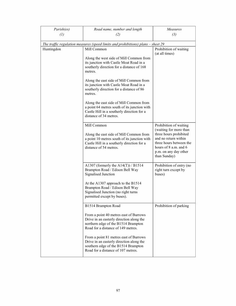
97
Parish(es)
(1)
Road name, number and length
(2)
Measures
(3)
The traffic regulation measures (speed limits and prohibitions) plans – sheet 29
Huntingdon Mill Common
Along the west side of Mill Common from
its junction with Castle Moat Road in a
southerly direction for a distance of 168
metres.
Along the east side of Mill Common from
its junction with Castle Moat Road in a
southerly direction for a distance of 86
metres.
Along the east side of Mill Common from
a point 64 metres south of its junction with
Castle Hill in a southerly direction for a
distance of 34 metres.
Prohibition of waiting
(at all times)
Mill Common
Along the east side of Mill Common from
a point 10 metres south of its junction with
Castle Hill in a southerly direction for a
distance of 54 metres.
Prohibition of waiting
(waiting for more than
three hours prohibited
and no return within
three hours between the
hours of 8 a.m. and 6
p.m. on any day other
than Sunday)
A1307 (formerly the A14(T)) / B1514
Brampton Road / Edison Bell Way
Signalised Junction
At the A1307 approach to the B1514
Brampton Road / Edison Bell Way
Signalised Junction (no right turns
permitted except by buses).
Prohibition of entry (no
right turn except by
buses)
B1514 Brampton Road
From a point 40 metres east of Burrows
Drive in an easterly direction along the
northern edge of the B1514 Brampton
Road for a distance of 149 metres.
From a point 81 metres east of Burrows
Drive in an easterly direction along the
southern edge of the B1514 Brampton
Road for a distance of 107 metres.
Prohibition of parking

98
Parish(es)
(1)
Road name, number and length
(2)
Measures
(3)
New Link Road
From its junction with Castle Moat Road
southwards along its entire length to the
point where it meets the A1307 (formerly
A14(T)).
Prohibition of parking
The traffic regulation measures (speed limits and prohibitions) plans – sheet 29
Huntingdon A1307 (formerly the A14(T))
From its junction with the B1514
Brampton Road / Edison Bell Way
Signalised Junction for a distance of 1312
metres in a south easterly direction
(including the signalised junction with
New Link Road).
Prohibition of parking
The traffic regulation measures (clearways and weight limits) plans – sheets 14, 15, 16, 17, 18,
19, 20, 21, 22, 23, 24, 28, 29, 30 and 36
Girton, Dry Drayton,
Oakington and
Westwick, Longstanton,
Lolworth, Swavesey,
Conington, Fen Drayton,
Fenstanton,
Hemingford Grey,
Hemingford Abbots,
Godmanchester
A1307 (formerly the A14(T))
From a point 595 metres north west of the
centre point of Girton Road to a point 680
metres south east of the New Link Road
Signalised Junction in Huntingdon
(including all roundabouts along the length
of the A1307 (formerly the A14(T)) for a
distance of 21.84 kilometres.
Clearway
(to include verges, hard
shoulders, slip roads and
laybys)
The traffic regulation measures (clearways and weight limits) plans – sheets 28 and 36
Huntingdon, The
Stukeleys, Alconbury
A1307 (formerly the A14(T))
From a point 500 metres north west of the
centre point of the A1307 Roundabout
junction located 475 metres north east of
Hinchingbrooke Park Road Signalised
Junction to a point 420 metres south east
of the B1043 overbridge at Alconbury, for
a distance of 4.73 kilometres.
Clearway
(to include verges, hard
shoulders, slip roads and
laybys)

99
PART 3
ROADS TO BE DE-TRUNKED
In the administrative areas of Huntingdon District Council and South Cambridgeshire
District Council
1. A length of approximately 18.9 kilometres of the A14 Trunk Road from point A on sheet 1 of
the De-Trunking Plans, being the point at which the A14 meets the B1043 at a roundabout
junction situated to the east of Alconbury, in a south-easterly direction to point B on sheet 15 of
the De-Trunking Plans, being a point on the A14 Trunk Road 130 metres south-east of the access
to Freisland Farm.
2. A length of approximately 3.1 kilometres of the A14 Trunk Road from point C on sheet 4 of
the De-Trunking Plans, being a point on the A14 Trunk Road 200 metres south-west of the
roundabout known as the Spittals Interchange situated west of Huntingdon, passing under the
existing B1514 overbridge and then continuing in a north-westerly direction to point D on sheet 13
of the De-Trunking Plans, being the point where the A14 Trunk Road meets the A1 Trunk Road at
the existing Brampton Hut Junction situated to the north-west of Brampton.
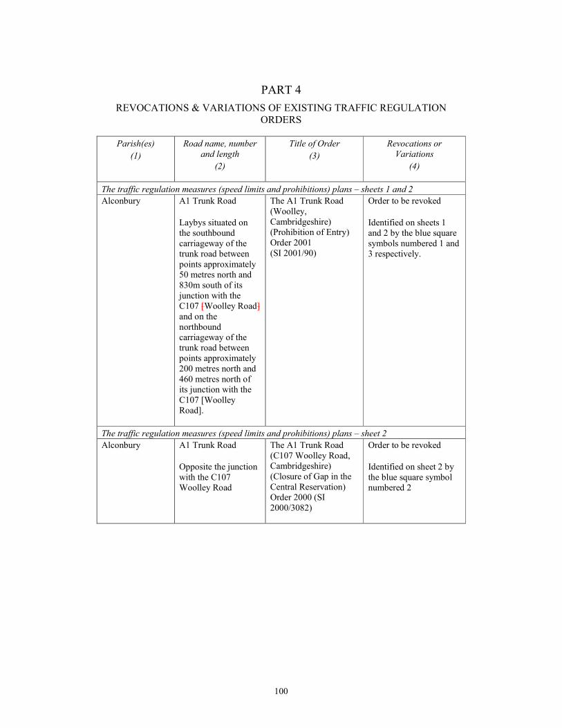
100
PART 4
REVOCATIONS & VARIATIONS OF EXISTING TRAFFIC REGULATION
ORDERS
Parish(es)
(1)
Road name, number
and length
(2)
Title of Order
(3)
Revocations or
Variations
(4)
The traffic regulation measures (speed limits and prohibitions) plans – sheets 1 and 2
Alconbury A1 Trunk Road
Laybys situated on
the southbound
carriageway of the
trunk road between
points approximately
50 metres north and
830m south of its
junction with the
C107 [Woolley Road]
and on the
northbound
carriageway of the
trunk road between
points approximately
200 metres north and
460 metres north of
its junction with the
C107 [Woolley
Road].
The A1 Trunk Road
(Woolley,
Cambridgeshire)
(Prohibition of Entry)
Order 2001
(SI 2001/90)
Order to be revoked
Identified on sheets 1
and 2 by the blue square
symbols numbered 1 and
3 respectively.
The traffic regulation measures (speed limits and prohibitions) plans – sheet 2
Alconbury A1 Trunk Road
Opposite the junction
with the C107
Woolley Road
The A1 Trunk Road
(C107 Woolley Road,
Cambridgeshire)
(Closure of Gap in the
Central Reservation)
Order 2000 (SI
2000/3082)
Order to be revoked
Identified on sheet 2 by
the blue square symbol
numbered 2
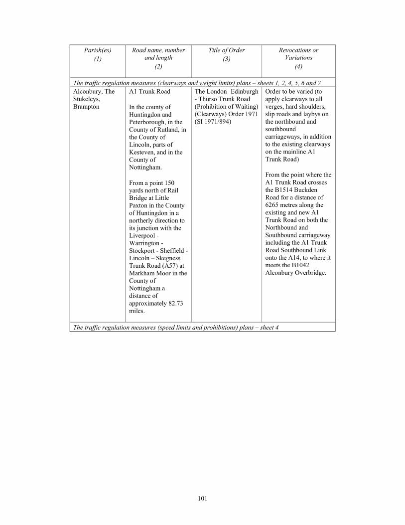
101
Parish(es)
(1)
Road name, number
and length
(2)
Title of Order
(3)
Revocations or
Variations
(4)
The traffic regulation measures (clearways and weight limits) plans – sheets 1, 2, 4, 5, 6 and 7
Alconbury, The
Stukeleys,
Brampton
A1 Trunk Road
In the county of
Huntingdon and
Peterborough, in the
County of Rutland, in
the County of
Lincoln, parts of
Kesteven, and in the
County of
Nottingham.
From a point 150
yards north of Rail
Bridge at Little
Paxton in the County
of Huntingdon in a
northerly direction to
its junction with the
Liverpool -
Warrington -
Stockport - Sheffield -
Lincoln – Skegness
Trunk Road (A57) at
Markham Moor in the
County of
Nottingham a
distance of
approximately 82.73
miles.
The London -Edinburgh
- Thurso Trunk Road
(Prohibition of Waiting)
(Clearways) Order 1971
(SI 1971/894)
Order to be varied (to
apply clearways to all
verges, hard shoulders,
slip roads and laybys on
the northbound and
southbound
carriageways, in addition
to the existing clearways
on the mainline A1
Trunk Road)
From the point where the
A1 Trunk Road crosses
the B1514 Buckden
Road for a distance of
6265 metres along the
existing and new A1
Trunk Road on both the
Northbound and
Southbound carriageway
including the A1 Trunk
Road Southbound Link
onto the A14, to where it
meets the B1042
Alconbury Overbridge.
The traffic regulation measures (speed limits and prohibitions) plans – sheet 4
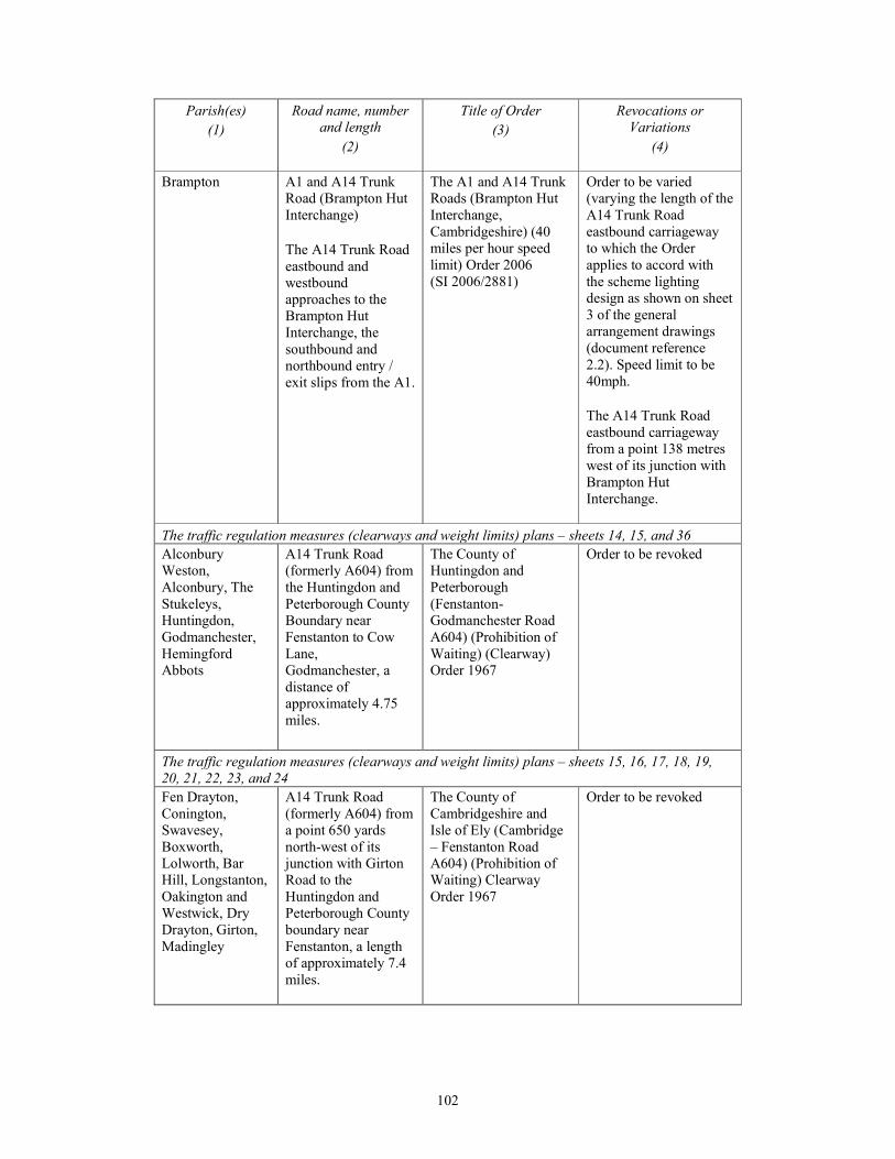
102
Parish(es)
(1)
Road name, number
and length
(2)
Title of Order
(3)
Revocations or
Variations
(4)
Brampton A1 and A14 Trunk
Road (Brampton Hut
Interchange)
The A14 Trunk Road
eastbound and
westbound
approaches to the
Brampton Hut
Interchange, the
southbound and
northbound entry /
exit slips from the A1.
The A1 and A14 Trunk
Roads (Brampton Hut
Interchange,
Cambridgeshire) (40
miles per hour speed
limit) Order 2006
(SI 2006/2881)
Order to be varied
(varying the length of the
A14 Trunk Road
eastbound carriageway
to which the Order
applies to accord with
the scheme lighting
design as shown on sheet
3 of the general
arrangement drawings
(document reference
2.2). Speed limit to be
40mph.
The A14 Trunk Road
eastbound carriageway
from a point 138 metres
west of its junction with
Brampton Hut
Interchange.
The traffic regulation measures (clearways and weight limits) plans – sheets 14, 15, and 36
Alconbury
Weston,
Alconbury, The
Stukeleys,
Huntingdon,
Godmanchester,
Hemingford
Abbots
A14 Trunk Road
(formerly A604) from
the Huntingdon and
Peterborough County
Boundary near
Fenstanton to Cow
Lane,
Godmanchester, a
distance of
approximately 4.75
miles.
The County of
Huntingdon and
Peterborough
(Fenstanton-
Godmanchester Road
A604) (Prohibition of
Waiting) (Clearway)
Order 1967
Order to be revoked
The traffic regulation measures (clearways and weight limits) plans – sheets 15, 16, 17, 18, 19,
20, 21, 22, 23, and 24
Fen Drayton,
Conington,
Swavesey,
Boxworth,
Lolworth, Bar
Hill, Longstanton,
Oakington and
Westwick, Dry
Drayton, Girton,
Madingley
A14 Trunk Road
(formerly A604) from
a point 650 yards
north-west of its
junction with Girton
Road to the
Huntingdon and
Peterborough County
boundary near
Fenstanton, a length
of approximately 7.4
miles.
The County of
Cambridgeshire and
Isle of Ely (Cambridge
– Fenstanton Road
A604) (Prohibition of
Waiting) Clearway
Order 1967
Order to be revoked

103
Parish(es)
(1)
Road name, number
and length
(2)
Title of Order
(3)
Revocations or
Variations
(4)
The traffic regulation measures (speed limits and prohibitions) plans – sheet 17
Boxworth Laybys adjacent to
the eastbound and
westbound
carriageways of the
trunk road at various
locations listed in the
Order indicated in
Column 3
The A14 Trunk Road
(Bythorn, Junction 15 –
Swavesey / Boxworth,
Junction 28)
(Prohibition of Entry)
Order 2008
(SI 2008/1010)
Order to be partially
revoked
Layby adjacent to the
westbound carriageway
of the A14 Trunk Road
situated between points
40 metres and 220
metres southeast of the
centre point of its
junction with the access
track leading to Friesland
Farm
Identified on sheet 17 by
the blue square symbol
numbered 4
The traffic regulation measures (speed limits and prohibitions) plans – sheets 17 and 18
Swavesey,
Boxworth
Boxworth and
Swavesey
(A14 westbound slip
off , A14 Westbound
slip on, High Street
and Boxworth End)
Cambridgeshire County
Council (Removal of
Restricted Roads
Status) (No 1) Order
2001
Order to be revoked
Identified on sheets 17
and 18 by the blue
square symbols
numbered 5 (sheet 17),
6, 7, 8, 9 and 10 (sheet
18)
The traffic regulation measures (speed limits and prohibitions) plans – sheet 19
Lolworth A14 Trunk Road
(formerly A604) gap
in the central
reservation
approximately 1300m
west of its junction
with the B1050 at Bar
Hill
The A604 Trunk Road
(Lolworth Turn,
Lolworth) (Prohibition
of use of gap in central
reservation) Order 1991
(SI 1991/2760)
Order to be revoked
Identified on sheet 19 by
the blue square symbol
numbered 12
A14 Junction with
Robin’s Lane
Splitter island
between the entry and
exit slips to Robins
Lane
The A14 Trunk Road
(Huntingdon
Road/Robins Lane
Junction, Lolworth,
Cambridgeshire)
(Prohibition of Traffic)
Order 2008 (SI
2008/2880)
Order to be revoked
Identified on sheet 19 by
the blue square symbol
numbered 11

104
Parish(es)
(1)
Road name, number
and length
(2)
Title of Order
(3)
Revocations or
Variations
(4)
The traffic regulation measures (speed limits and prohibitions) plans – sheet 20
Bar Hill A14 Trunk Road
(formerly A604)
At the junction with
the private access
serving Lolworth
Petrol Station
The Trunk Road (A604)
(Temporary Restriction
of Traffic) Order 1978
(SI 1978/555)
Order to be revoked
Identified on sheet 20 by
the blue square symbol
numbered 13
The traffic regulation measures (speed limits and prohibitions) plans – sheet 21
Oakington and
Westwick
A14 Trunk Road
Layby situated on the
eastbound
carriageway of the
trunk road between
points 330 metres east
and 610 metres east
of the Oakington /Dry
Drayton Road Bridge.
The A14 Trunk Road
(Oakington/Dry
Drayton Interchange,
Cambridgeshire)
(Prohibition of Entry)
Order 2002
(SI 2002/2472)
Order to be revoked
Identified on sheets 21
by the blue square
symbol numbered 14
The traffic regulation measures (speed limits and prohibitions) plans – sheet 23 and 24
Girton Huntingdon Road
Orders along the
northeast side from a
point 112 metres
northwest of its
junction with Girton
Road in a north
westerly direction to
its junction with the
eastern side of the slip
road to the eastbound
carriageway of the
Trunk Road A14
Cambridge Northern
Bypass.
Orders along
southwest side from
its junction with
Girton Road in a
north westerly
direction for a
distance of 720
metres
Cambridgeshire County
Council (Huntingdon
Road, Girton)
(Bus/Cycle Lane,
Prohibition of Waiting
and Loading Order
1998
Order to be revoked
Identified on sheets 23
and 24 by the blue
square symbols
numbered 15, 16, 17,
(sheet 23) 18 and 19
(sheet 24)
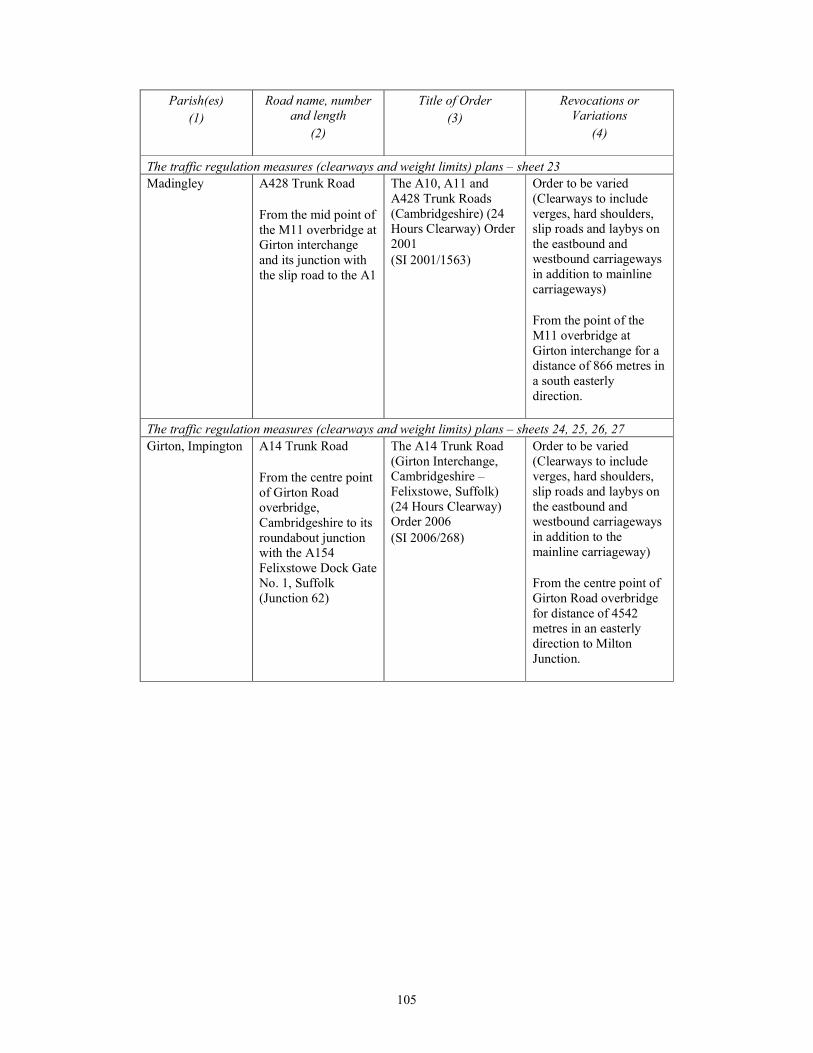
105
Parish(es)
(1)
Road name, number
and length
(2)
Title of Order
(3)
Revocations or
Variations
(4)
The traffic regulation measures (clearways and weight limits) plans – sheet 23
Madingley A428 Trunk Road
From the mid point of
the M11 overbridge at
Girton interchange
and its junction with
the slip road to the A1
The A10, A11 and
A428 Trunk Roads
(Cambridgeshire) (24
Hours Clearway) Order
2001
(SI 2001/1563)
Order to be varied
(Clearways to include
verges, hard shoulders,
slip roads and laybys on
the eastbound and
westbound carriageways
in addition to mainline
carriageways)
From the point of the
M11 overbridge at
Girton interchange for a
distance of 866 metres in
a south easterly
direction.
The traffic regulation measures (clearways and weight limits) plans – sheets 24, 25, 26, 27
Girton, Impington A14 Trunk Road
From the centre point
of Girton Road
overbridge,
Cambridgeshire to its
roundabout junction
with the A154
Felixstowe Dock Gate
No. 1, Suffolk
(Junction 62)
The A14 Trunk Road
(Girton Interchange,
Cambridgeshire –
Felixstowe, Suffolk)
(24 Hours Clearway)
Order 2006
(SI 2006/268)
Order to be varied
(Clearways to include
verges, hard shoulders,
slip roads and laybys on
the eastbound and
westbound carriageways
in addition to the
mainline carriageway)
From the centre point of
Girton Road overbridge
for distance of 4542
metres in an easterly
direction to Milton
Junction.
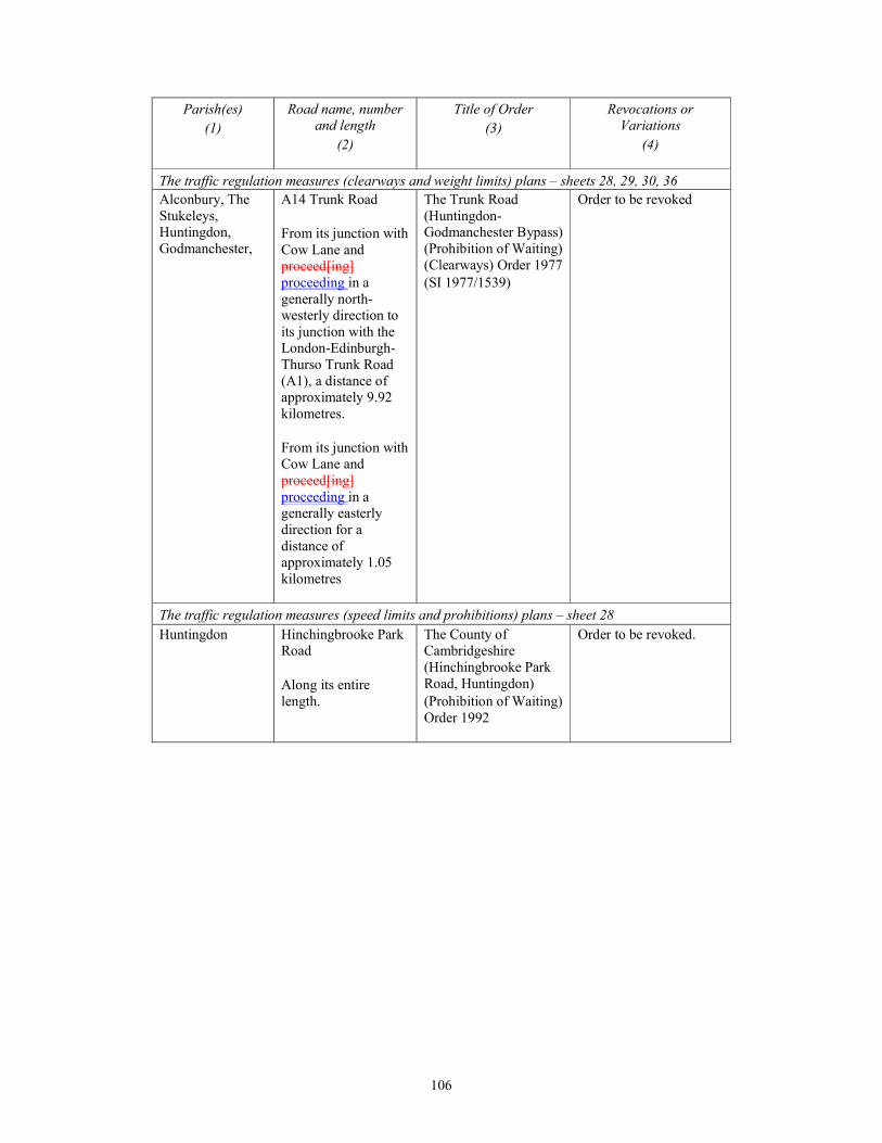
106
Parish(es)
(1)
Road name, number
and length
(2)
Title of Order
(3)
Revocations or
Variations
(4)
The traffic regulation measures (clearways and weight limits) plans – sheets 28, 29, 30, 36
Alconbury, The
Stukeleys,
Huntingdon,
Godmanchester,
A14 Trunk Road
From its junction with
Cow Lane and
proceed[ing]
proceeding in a
generally north-
westerly direction to
its junction with the
London-Edinburgh-
Thurso Trunk Road
(A1), a distance of
approximately 9.92
kilometres.
From its junction with
Cow Lane and
proceed[ing]
proceeding in a
generally easterly
direction for a
distance of
approximately 1.05
kilometres
The Trunk Road
(Huntingdon-
Godmanchester Bypass)
(Prohibition of Waiting)
(Clearways) Order 1977
(SI 1977/1539)
Order to be revoked
The traffic regulation measures (speed limits and prohibitions) plans – sheet 28
Huntingdon Hinchingbrooke Park
Road
Along its entire
length.
The County of
Cambridgeshire
(Hinchingbrooke Park
Road, Huntingdon)
(Prohibition of Waiting)
Order 1992
Order to be revoked.
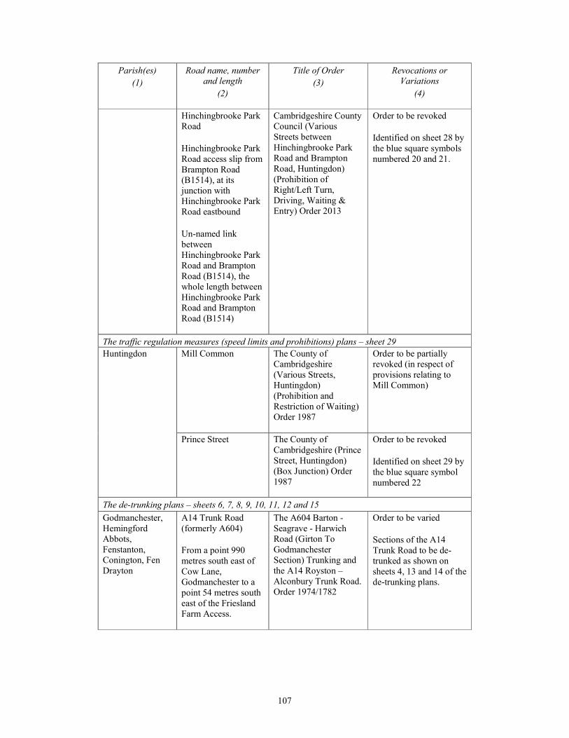
107
Parish(es)
(1)
Road name, number
and length
(2)
Title of Order
(3)
Revocations or
Variations
(4)
Hinchingbrooke Park
Road
Hinchingbrooke Park
Road access slip from
Brampton Road
(B1514), at its
junction with
Hinchingbrooke Park
Road eastbound
Un-named link
between
Hinchingbrooke Park
Road and Brampton
Road (B1514), the
whole length between
Hinchingbrooke Park
Road and Brampton
Road (B1514)
Cambridgeshire County
Council (Various
Streets between
Hinchingbrooke Park
Road and Brampton
Road, Huntingdon)
(Prohibition of
Right/Left Turn,
Driving, Waiting &
Entry) Order 2013
Order to be revoked
Identified on sheet 28 by
the blue square symbols
numbered 20 and 21.
The traffic regulation measures (speed limits and prohibitions) plans – sheet 29
Huntingdon Mill Common The County of
Cambridgeshire
(Various Streets,
Huntingdon)
(Prohibition and
Restriction of Waiting)
Order 1987
Order to be partially
revoked (in respect of
provisions relating to
Mill Common)
Prince Street The County of
Cambridgeshire (Prince
Street, Huntingdon)
(Box Junction) Order
1987
Order to be revoked
Identified on sheet 29 by
the blue square symbol
numbered 22
The de-trunking plans – sheets 6, 7, 8, 9, 10, 11, 12 and 15
Godmanchester,
Hemingford
Abbots,
Fenstanton,
Conington, Fen
Drayton
A14 Trunk Road
(formerly A604)
From a point 990
metres south east of
Cow Lane,
Godmanchester to a
point 54 metres south
east of the Friesland
Farm Access.
The A604 Barton -
Seagrave - Harwich
Road (Girton To
Godmanchester
Section) Trunking and
the A14 Royston –
Alconbury Trunk Road.
Order 1974/1782
Order to be varied
Sections of the A14
Trunk Road to be de-
trunked as shown on
sheets 4, 13 and 14 of the
de-trunking plans.
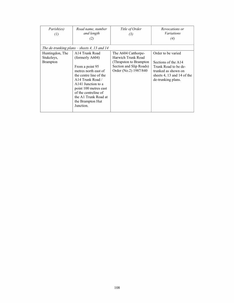
108
Parish(es)
(1)
Road name, number
and length
(2)
Title of Order
(3)
Revocations or
Variations
(4)
The de-trunking plans – sheets 4, 13 and 14
Huntingdon, The
Stukeleys,
Brampton
A14 Trunk Road
(formerly A604)
From a point 95
metres north east of
the centre line of the
A14 Trunk Road /
A141 Junction to a
point 100 metres east
of the centreline of
the A1 Trunk Road at
the Brampton Hut
Junction.
The A604 Catthorpe-
Harwich Trunk Road
(Thrapston to Brampton
Section and Slip Roads)
Order (No.2) 1987/840
Order to be varied
Sections of the A14
Trunk Road to be de-
trunked as shown on
sheets 4, 13 and 14 of the
de-trunking plans.
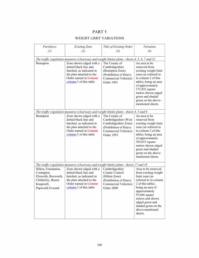
109
PART 5
WEIGHT LIMIT VARIATIONS
Parish(es)
(1)
Existing Zone
(2)
Title of Existing Order
(3)
Variation
(4)
The traffic regulation measures (clearways and weight limits) plans– sheets 4, 5, 6, 7 and 31
Brampton Zone shown edged with a
dotted black line and
hatched, as indicated in
the plan attached to the
Order named in Column
column 3 of this table
The County of
Cambridgeshire
(Brampton Zone)
(Prohibition of Heavy
Commercial Vehicles)
Order 1991
An area to be
removed from
existing weight limit
zone (as referred to
in column 2 of this
table), being an area
of approximately
272,822 square
metres shown edged
green and shaded
green on the above-
mentioned sheets.
The traffic regulation measures (clearways and weight limits) plans– sheets 4, 5 and 6
Brampton Zone shown edged with a
dotted black line and
hatched, as indicated in
the plan attached to the
Order named in Column
column 3 of this table
The County of
Cambridgeshire (West
Cambridgeshire Zone)
(Prohibition of Heavy
Commercial Vehicles)
Order 1993
An area to be
removed from
existing weight limit
zone (as referred to
in column 2 of this
table), being an area
of approximately
303,015 square
metres shown edged
green and shaded
green on the above-
mentioned sheets.
The traffic regulation measures (clearways and weight limits) plans– sheets 17 and 18
Hilton, Fenstanton,
Conington,
Elsworth, Boxworth,
Childerley, Bourn
Knapwell,
Papworth Everard
Zone shown edged with a
dotted black line and
hatched, as indicated in
the plan attached to the
Order named in Column
column 3 of this table
Cambridgeshire
County Council
(Hilton Zone)
(Prohibition of Heavy
Commercial Vehicles)
Order 2000
Area to be removed
from existing weight
limit zone (as
referred to in column
2 of this table),
being an area of
approximately
93,666 square
metres and shown
edged green and
shaded green on the
above-mentioned
sheets.
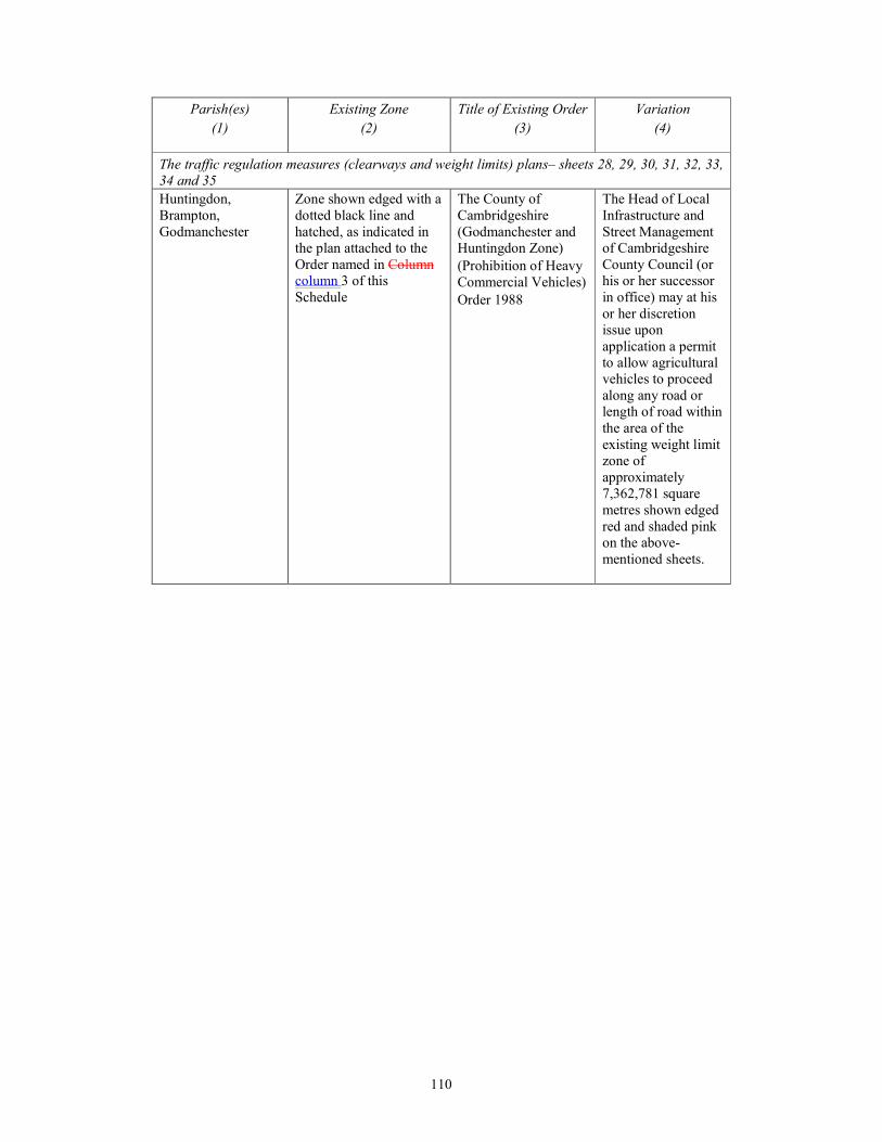
110
Parish(es)
(1)
Existing Zone
(2)
Title of Existing Order
(3)
Variation
(4)
The traffic regulation measures (clearways and weight limits) plans– sheets 28, 29, 30, 31, 32, 33,
34 and 35
Huntingdon,
Brampton,
Godmanchester
Zone shown edged with a
dotted black line and
hatched, as indicated in
the plan attached to the
Order named in Column
column 3 of this
Schedule
The County of
Cambridgeshire
(Godmanchester and
Huntingdon Zone)
(Prohibition of Heavy
Commercial Vehicles)
Order 1988
The Head of Local
Infrastructure and
Street Management
of Cambridgeshire
County Council (or
his or her successor
in office) may at his
or her discretion
issue upon
application a permit
to allow agricultural
vehicles to proceed
along any road or
length of road within
the area of the
existing weight limit
zone of
approximately
7,362,781 square
metres shown edged
red and shaded pink
on the above-
mentioned sheets.
111
PART 6
CLASSIFICATION OF ROADS
In the administrative area of Cambridgeshire County Council—
1.THE NEW A14 TRUNK ROAD
27.33 km length of new highway
1. A 27.33 km length of new highway to be classified (as identified in paragraphs 1(a) to 1(c)
below) as part of the A14 Trunk Road (such length also including existing highway to be
improved, as identified in paragraph 1(d) below)—
(a) commencing from a point 298 metres east of the point where Footpath Ellington 23 (also
known as Footpath 71/23), runs adjacent to the eastern boundary of the pumping station,
located to the south of the A14, and continuing from that point in an easterly then a south-
easterly direction for a distance of 1.45 km to the centre point of a bridge which is
proposed to be constructed over the existing A1 Trunk Road to carry this new A14 Trunk
Road;
(b) then continuing in a south-easterly then a south-south-easterly direction for a distance of
1.97 km to the centre point beneath a proposed bridge which is to be constructed to carry
the new link between the southbound carriageway of the existing A1 Trunk Road and the
new A14 Trunk Road;
(c) then continuing in a south-easterly, then an easterly, then a south-easterly direction for a
distance of 16.32 km to the point where it meets Bridleway 225/14 (towards the east of
the A14 Swavesey Junction); and
(d) then continuing in a south-easterly direction along the existing A14 Trunk Road for a
distance of 7.59 km to a point 514 metres south-east of where Beck Brook passes below
the A14 Trunk Road in a culvert (towards the north-east of the A14 Girton Interchange).,
identified by a blue line on the classification of roads plans – sheets 1 and 2.
474 metre length of new highway
2. A 474 metre length of new highway (as identified in paragraphs (a) and (b) below) to be
classified as part of the A14 Trunk Road (together with existing highway to be improved, as
identified in paragraph (c) below)—
(a) commencing from its junction with the roundabout proposed to be constructed and known
as the Southern New Ellington Roundabout, and continuing in a north-easterly direction
for a distance of 198 metres to the roundabout proposed to be constructed and known as
the Northern New Ellington Roundabout, plus the entire circumferences of the proposed
Southern Ellington Roundabout and Northern Ellington Roundabout;
(b) then continuing from its junction with the proposed Northern Ellington Roundabout, in an
east-north-easterly direction for a distance of 215 metres to a point where it meets the
existing A14 Trunk Road alignment; and
(c) then continuing in an easterly direction for a distance of 292 metres along the existing
A14 Trunk Road alignment to the existing roundabout known as Brampton Hut
Interchange;,
identified by a blue line on the classification of roads plans – sheet 1.

112
Girton Interchange A14 Eastbound Link
3. A 2.1 km length of new highway to be classified as part of the A14 Trunk Road commencing
from a point 65 metres north-west of the point where Beck Brook passes below the existing A14
Trunk Road in a culvert (to the west of the existing Girton Interchange) and continuing in a south-
easterly direction for a distance of 2048 metres to its junction with the existing A14 Trunk Road;,
identified by a blue line on the classification of roads plans – sheet 2.
Girton Interchange A14 Westbound Link
4. A 2 km length of new highway to be classified as part of the A14 Trunk Road commencing
from a point 85 metres north-east of the centrepoint of the overbridge carrying the existing A14
Trunk Road over the existing M11 motorway (the M11 Overbridge) and continuing in a westerly
then a north-north-westerly direction to a point 158 metres north-west of where Beck Brook
passes below the existing A14 Trunk Road in a culvert;,
identified by a blue line on the classification of roads plans – sheet 2.
2.THE NEW A14 TRUNK ROAD AND A1 TRUNK ROAD BRAMPTON INTERCHANGE
SLIP ROADS
A1 Southbound Link to A14
5. A 1.8 km length of new highway to be classified as part of the A1 Trunk Road commencing
from a point 373 metres north of the centre point of where the southbound carriageway of the
existing A1 Trunk Road passes under the proposed overbridge to be constructed to carry the C167
Grafham Road over the existing A1 Trunk Road, and continuing in a southerly and then south-
easterly direction over the proposed A14 Trunk Road to be constructed, to where it merges with
the eastbound carriageway of the proposed A14 Trunk Road, at a point 528 metres south east of
the centre point of where it passes over the realigned B1514 Buckden Road;,
identified by a red line on the classification of roads plans - sheet 1.
A14 Northbound Link to A1
6. A 1.75 km length of new highway to be classified as part of the A14 Trunk Road
commencing from the point 343 metres south-east of where the westbound carriageway of the
proposed A14 Trunk Road to be constructed passes over the proposed realignment of the existing
B1514 Buckden Road, to the point where it merges with the northbound carriageway of the
existing A1 Trunk Road 483 metres north of the point where the northbound carriageway of the
existing A1 Trunk Road passes under the proposed overbridge to be constructed to carry the C167
Grafham Road over the existing A1 Trunk Road;,
identified by a blue line on the classification of roads plans - sheet 1.
3.THE NEW A14 TRUNK ROAD GIRTON INTERCHANGE SLIP ROADS
Westbound Merge (there is no Westbound Diverge)
7. A 813 metre length of new bifurcated slip road, to be classified as part of the A14 Trunk
Road, commencing at the junction of the slip road with the roundabout proposed to be constructed
and known as Girton Roundabout West and continuing in a northerly then a north-westerly
direction to where a point where it merges with the westbound carriageway of the existing A14
Trunk Road, at a point 266 metres south-east of where Beck Brook passes under the existing A14
Trunk Road in a culvert;,
identified by a blue line on classification of roads plans - sheet 2.
113
Eastbound Diverge (there is no Eastbound Merge)
8. A 580 metre length of new bifurcated slip road, to be classified as part of the A14 Trunk
Road, commencing at the centrepoint on the eastbound carriageway of the existing A14 Trunk
Road at a point 56 metres southeast of the centre point of where the eastbound carriageway of the
existing A14 Trunk Road passes over Beck Brook (in culvert), continuing in a south-easterly
direction to the point where it merges with the roundabout proposed to be constructed and known
as Girton Roundabout East;,
identified by a blue line on the classification of roads plans - sheet 2.
4.THE NEW A14 TRUNK ROAD BAR HILL JUNCTION SLIP ROADS
Westbound merge
9. A 866 metre length of new bifurcated slip road, to be classified as part of the A14 Trunk
Road, commencing at its junction with the roundabout proposed to be constructed and known as
Bar Hill Junction (an alteration to the existing A14 Trunk Road junction at Bar Hill) and
continuing in a north-westerly direction to the point where it merges with the westbound
carriageway of the existing A14 Trunk Road at a point 645 metres north-west of the point where
the Longstanton Brook passes (in culvert) under the existing westbound carriageway of the
existing A14 Trunk Road;,
identified by a blue line on the classification of roads plans - sheet 2.
Westbound diverge
10. A 613 metre length of new bifurcated slip road, to be classified as part of the A14 Trunk
Road, commencing from a point 162 metres north-west of where the boundary between
Longstanton Parish and Oakington and Westwick Parish crosses the centrepoint of the westbound
carriageway of the existing A14 Trunk Road, and continuing to its junction with the roundabout
proposed to be constructed and known as Bar Hill Junction (as an alteration to the existing A14
Trunk Road Junction at Bar Hill);,
identified by a blue line on the classification of roads plans - sheet 2.
Eastbound Merge
11. A 735 metre length of new bifurcated slip road, to be classified as part of the A14 Trunk
Road, commencing from its junction with the roundabout proposed to be constructed and known
as Bar Hill Junction (as an alteration to the existing A14 Trunk Road), and continuing in a south-
easterly direction to the point where it merges with the eastbound carriageway of the existing A14
Trunk Road at a point 282 metres north-west of where the boundary between Longstanton Parish
and Oakington and Westwick Parish crosses the centrepoint of the eastbound carriageway of the
existing A14 Trunk Road;,
identified by a blue line on the classification of roads plans - sheet 2.
Eastbound Diverge
12. A 598 metre length of new bifurcated slip road, to be classified as part of the A14 Trunk
Road, commencing at a point 387 metres north-west of the point where the Longstanton Brook
passes (in culvert) under the eastbound carriageway of the existing A14 Trunk Road, and
continuing to its junction with the roundabout proposed to be constructed and known as Bar Hill
Junction (as an alteration to the existing A14 Trunk Road);,
identified by a blue line on classification of roads plans - sheet 2.

114
5.THE NEW A14 CAMBRIDGE SERVICES JUNCTION SLIP ROAD
826 metre length of new bifurcated slip road
13. A 826 metre length of new bifurcated slip road, to be classified as part of the A14 Trunk
Road, commencing at a point 180 metres north-west of the point where Utton’s Drove Drain
passes under the westbound carriageway of the existing A14 Trunk Road, and continuing in a
north-westerly direction to its junction with the roundabout proposed to be constructed and known
as ‘Cambridge Services Roundabout’;,
identified by a blue line on the classification of roads plans - sheet 2.
6.THE NEW A14 TRUNK ROAD SWAVESEY JUNCTION SLIP ROADS
Westbound Diverge
14. A 938 metre length of new bifurcated slip road, to be classified as part of the A14 Trunk
Road, commencing at a point 625 metres north-west of the point where Utton’s Drove Drain
passes under the westbound carriageway of the existing A14 Trunk Road, and continuing in a
north-westerly direction to its junction with the roundabout proposed to be constructed and known
as the Southern Swavesey Roundabout;,
identified by a blue line on the classification of roads plans - sheet 2.
Westbound Merge
15. A 666 metre length of new bifurcated slip road, to be classified as part of the A14 Trunk
Road, commencing at its junction with the roundabout proposed to be constructed and known as
the South Swavesey Roundabout, and continuing in a north-westerly direction to the point where it
merges with the westbound carriageway of the proposed A14 Trunk Road to be constructed at a
point 30 metres east of where Scotland Drove Drain passes under the existing A14 Trunk Road;,
identified by a blue line on the classification of roads plans - sheet 2.
Eastbound Diverge
16. A 638 metre length of new bifurcated slip road, to be classified as part of the A14 Trunk
Road, commencing at the centrepoint of where the eastbound carriageway of the existing A14
Trunk Road passes under the overbridge proposed to be constructed to carry an unclassified road,
to connect the roundabout proposed to be constructed and known as Southern Swavesey
Roundabout to the roundabout proposed to be constructed and known as Northern Swavesey
Roundabout, and continuing from that point in a south-easterly and then a north-westerly direction
to its junction with the proposed Northern Swavesey Roundabout;,
identified by a blue line on the classification of roads plans - sheet 2.
Eastbound Merge
17. A 1.2km length of new bifurcated slip road, to be classified as part of the A14 Trunk Road,
commencing at its junction with the roundabout proposed to be constructed and known as the
Northern Swavesey Roundabout, and continuing in a south-easterly direction to the point where it
merges with the eastbound carriageway of the existing A14 Trunk Road at a point 1172 metres
south-east of the centrepoint of the eastbound carriageway of the existing A14 Trunk Road where
it passes under the overbridge which is proposed to be constructed between the proposed Northern
Swavesey Roundabout and the roundabout proposed to be constructed and known as Southern
Swavesey Roundabout;,
identified by a blue line on the classification of roads plans - sheet 2.

115
7.THE NEW A14 TRUNK ROAD A1198 ERMINE STREET JUNCTION SLIP ROADS
Eastbound Diverge (there is no Westbound Diverge)
18. A 595 metre length of new bifurcated slip road, to be classified as part of the A14 Trunk
Road, commencing from the point 1007 metres east of the centrepoint of where the eastbound
carriageway of the existing A14 Trunk Road passes under the overbridge which is proposed to be
constructed to carry the realigned unclassified road known as Silver Street over the new A14
Trunk Road, and continuing in a north-easterly direction to its junction with the roundabout
proposed to be constructed and known as the Northern Ermine Street Roundabout;,
identified by a blue line on the classification of roads plans - sheet 1.
Westbound Merge (there is no Eastbound Merge)
19. A 729 metre length of new bifurcated slip road, to be classified as part of the A14 Trunk
Road, commencing from its junction with the roundabout proposed to be constructed and known
as the Southern Ermine Street Roundabout, and continuing in a north-westerly direction to the
point where it merges with the westbound carriageway of the new A14 Trunk Road at a point 992
metres east of the centrepoint of where the westbound carriageway of the new A14 Trunk Road
passes under the overbridge which is proposed to be constructed to carry the realigned unclassified
road Silver Street over the new A14 Trunk Road;,
identified by a blue line on the classification of roads plans - sheet 1.
8.THE NEW A1 TRUNK ROAD
Realigned A1 Trunk Road Brampton Interchange to Brampton Hut Interchange
20. A 2.9 km length of new highway to be classified as part of the A1 Trunk Road commencing
from a point 4 metres north of the centrepoint of the existing overbridge carrying the existing A1
Trunk Road over the existing B1514 Buckden Road and continuing in a north-north-westerly, then
northerly, then north-westerly, then north-north-easterly direction for a distance of 2.9 km to a
point where it merges with the existing A1 Trunk Road, at a point 92 metres south of the
centrepoint of the existing roundabout known as Brampton Hut Interchange;,
identified by a red line on the classification of roads plans - sheet 1.
9.THE A141 CLASSIFIED ROAD
Approximately 3.2 km of the existing A14 highway
21. A length of approximately 3.2 km of the existing A14 highway to be re-classified as the
A141 Classified Road, from the existing roundabout known as the Spittals Interchange, in a south-
westerly direction, passing under the existing B1514 overbridge, and then continuing in a north-
westerly direction to the existing roundabout known as the Brampton Hut Junction;,
identified by a green line on the classification of roads plans - sheet 1.
10.THE A1307 CLASSIFIED ROAD (HUNTINGDON ROAD)
22.2 km length of new highway
22. A 22.2 km length of new highway, to be classified as the A1307 Classified Road (such
length also including existing highway to be improved, as identified in paragraph (k) below)—
(a) commencing from its junction with the roundabout proposed to be constructed and known
as Girton Roundabout East, (as an alteration to the existing A1307 Huntingdon Road) and
116
continuing in a west-north-westerly direction for a distance of 615 metres to the
roundabout proposed to be constructed and known as Girton Roundabout West (as an
alteration to the existing A1307 Huntingdon Road) and including the entire circumference
of the Girton Roundabout East and the Girton Roundabout West;
(b) then extending from its junction with the proposed Girton Roundabout West in a west-
north-westerly direction and then in a north-westerly direction for a distance of 1.6 km to
its junction with the proposed Cambridge Crematorium Access Road to be constructed,
and then extending in a north-westerly direction for a distance of 415 metres to the
roundabout proposed to be constructed and known as ‘Oakington Road Roundabout’ (as
an alteration to the existing C193 Oakington Road) including the entire circumference of
the proposed Oakington Road Roundabout;
(c) then continuing from its junction with the proposed Oakington Road Roundabout in an
east-north-easterly direction and then in a north-easterly direction for a distance of 629
metres to the Dry Drayton Roundabout which is proposed to be constructed (as an
alteration to the existing C197 Dry Drayton Road) including the entire circumference of
the proposed Drayton Road Roundabout;
(d) then continuing from its junction with the proposed Dry Drayton Roundabout in a west-
north-westerly direction, then in a north-north-westerly direction for a distance of 1.6 km
to its junction with the proposed Link Road to be constructed from the existing B1050
Hattons Road;
(e) then extending in a north-westerly direction under the bridge proposed to be constructed
(as an alteration and realignment of the existing B1050 Hattons Road) and continuing in a
north-westerly direction for a distance of 1.5 km to a centrepoint under the bridge
proposed to be constructed over the existing A14 Trunk Road (as a realignment and
extension of the existing unclassified Robin’s Lane);
(f) then extending in a north-westerly direction for a distance of 89 metres to its junction
with the proposed realignment and extension of the existing unclassified Robin’s Lane,
and then continuing in a north-westerly direction for a distance of 997 metres to the east
of the existing A14 Eastbound Cambridge Services;
(g) then continuing around the A14 Eastbound Cambridge Services in a north-easterly then
north-westerly, then south-westerly direction for a distance of 370 metres to a point just
west of the existing A14 Eastbound Cambridge Services (off the A14 eastbound mainline
carriageway);
(h) then continuing in a north-westerly direction for a distance of 308 metres, to a centrepoint
under the new footbridge for non-motorised users which is proposed to be constructed
close to the Bucking Way Business Park, then extending in a north-easterly direction for a
distance of 161 metres to its junction with the new local access road which is proposed to
be constructed, and then continuing north-eastwards for a distance of 238 metres to the
roundabout proposed to be constructed and known as the Bucking Way Road Roundabout
(as an alteration to the existing C186 Bucking Way Road);
(i) then continuing from its junction with the proposed Bucking Way Road roundabout for a
distance of 240 metres in a westerly then a south-westerly direction to the roundabout
which is proposed to be constructed and known as the Northern Swavesey Roundabout ;
(j) then continuing in a north-westerly direction for a distance of 1.1 km to a point 519
metres west of the point where it meets Bridleway 225/14;
(k) then continuing along the route of the existing A14 Trunk Road, proposed to be
reclassified as the A1307 road, for a distance of 11.7 kilometres to its junction with the
existing unclassified path crossing Mill Common; and
(l) then continuing in a northerly direction for a distance of 664 metres to its junction with
the proposed realignment of the existing B1514 Brampton Road in Huntingdon;,
identified by a pink line on the classification of roads plans - sheets 1 and 2.
117
469 metre length of new highway
23. A 469 metre length of new highway to be constructed and classified as part of the A1307
Classified Road, commencing from its junction with the proposed realignment of the unclassified
Hinchingbrooke Park Road, and continuing in a north-easterly direction to its junction with the
roundabout proposed to be constructed and known as Views Common Roundabout;,
identified by a pink line on the classification of roads plans – sheet 1.
5.3km length of the existing A14
24. A 5.3km length of the existing A14 which is proposed to be re-classified as part of the
A1307 Classified Road, commencing from its junction with the roundabout proposed to be
constructed and known as Views Common Roundabout, and continuing in a north-westerly
direction to its junction with the A141 at the existing roundabout known as Spittals Interchange,
and continuing to a point 420 metres south-east of the existing bridge carrying the existing B1043
over the existing A1(M) road, including the entire circumference of the proposed Views Common
Roundabout;,
identified by a pink line on the classification of roads plans - sheet 1.
11.B1514 BUCKDEN CLASSIFIED ROAD
874 metre length of new highway
25. A 874 metre length of new highway to be classified as part of the B1514 Buckden
RoadRoad—
(a) commencing at a point 206 metres west of the roundabout proposed to be constructed and
known as Buckden Road Roundabout (as part of an alteration to the alignment of the
existing B1514 Buckden Road), and continuing in a north-easterly direction to its
junction with the proposed Buckden Road Roundabout; and
(b) continuing from the proposed Buckden Road Roundabout in a north-easterly direction
under the overbridge proposed to be constructed (to carry the new A14 Trunk Road and
the improved A1 Trunk Road) for a distance of 668 metres to the point where it merges
with the existing B1514 Buckden Road at a distance of 761 metres southwest of its
junction with the unadopted road known as Park Lane, including the entire circumference
of the proposed Buckden Road Roundabout;,
identified by an orange dashed line on the classification of roads plans - sheet 1.
12.B1043 OFFORD ROAD CLASSIFIED ROAD
1.1 km length of new highway
26. A 1.1 km length of new highway to be classified as part of the B1043 Offord Road from a
point 511 metres south-west of the point where the boundary between Godmanchester Parish and
Offord Cluny and Offord D’Arcy Parish crosses the new A14 Trunk Road which is proposed to be
constructed, continuing in a north-easterly direction and traversing an overbridge (which is
proposed to be constructed over the proposed new A14 Trunk Road alignment) to the point where
it merges with the existing B1043 Offord Road, 482 metres north-east of the centrepoint of its
proposed overbridge crossing the new A14 Trunk Road;,
identified by an orange dashed line on the classification of roads plans - sheet 1.

118
13.A1198 ERMINE STREET CLASSIFIED ROAD
1.1 km length of new highway
27. A 1.1 km length of new highway to be classified as part of the A1198 Ermine StreetStreet—
(a) commencing from a point 347 metres south-west of a roundabout proposed to be
constructed and known as the Ermine Street Roundabout South, and continuing in a
north-easterly direction to its junction with the proposed Ermine Street Roundabout
South, for a distance of 406 metres including the entire circumference of the proposed
Ermine Street Roundabout South;
(b) then continuing from its junction with the proposed Ermine Street Roundabout South in a
north-westerly direction across an overbridge proposed to be constructed over the new
A14 Trunk Road, for a distance of 183 metres to its junction with the roundabout
proposed to be constructed and known as Ermine Street Roundabout North; and
(c) then continuing from the Ermine Street Roundabout North in a north-westerly direction
for a distance of 495 metres to the point where it merges with the existing A1198 Ermine
Street, at a point 585 metres north of the new A14 Trunk Road, including the entire
circumference of the proposed Ermine Street Roundabout North;,
identified by an orange line on the classification of roads plans - sheet 1.
14.B1040 POTTON ROAD CLASSIFIED ROAD
1 km length of new highway
28. A 1 km length of new highway to be classified as part of the B1040 Potton Road
commencing from a point 563 metres north-east of West Brook (where West Brook converges
with the point at which the Parish boundaries of Hilton, Fenstanton and Hemingford Grey all
meet) and continuing in a north-easterly direction for a distance of 1 km, to the point where it
merges with the existing B1040 Potton Road;,
identified by an orange dashed line on the classification of roads plans - sheet 1.
15.B1050 HATTONS ROAD CLASSIFIED ROAD
812 metre length of new highway
29. A 812 metre length of new highway to be classified as part of the B1050 Hattons
RoadRoad—
(a) commencing at its junction with the existing roundabout known as Saxon Way
Roundabout and continuing in a north-westerly then a north-easterly direction for a
distance of 144 metres to its junction with the roundabout proposed to be constructed and
known as Bar Hill Junction (as an alteration to the existing A14 Trunk Road); and
(b) then continuing from the Bar Hill Junction for a distance of 668 metres in a north-easterly
direction to a point where it merges with the existing B1050 Hattons Road, at a point 601
metres north-east of the centre point of the Bar Hill Junction circulatory carriageway,
including the entire circumference of the Bar Hill Junction circulatory carriageway’,
identified by an orange dashed line on the classification of roads plans - sheet 2.
191 metre length of new highway
30. A 191 metre length of new highway to be classified as part of the B1050 Hattons Road,
commencing from its junction with the new A1307 (which is proposed to be constructed), and
continuing for a distance of 191 metres to its junction with the existing B1050 Hattons Road (on
119
its new realignment which is proposed to be constructed) to a point 211 metres north-east of the
proposed new Bar Hill Junction circulatory carriageway;,
identified by an orange dashed line on the classification of roads plans - sheet 2.
16.C181 HILTON ROAD CLASSIFIED ROAD
967 metre length of new highway
31. A 967 metre length of new highway to be classified as the C181 Hilton Road commencing
from a point 129 metres north east of where the boundary between Hilton Parish and Fenstanton
Parish crosses the existing C181 Hilton Road, and continuing in a north-easterly then a north-
north-easterly direction crossing a new overbridge (which is proposed to be constructed over the
new A14 Trunk Road) to a point where it merges with the existing C181 Hilton Road, at a point
206 metres south-west of its junction with the existing unclassified road known as Pear Tree
Close;,
identified by a pink dashed line on the classification of roads plans - sheet 1.
17.C340 BRAMPTON ROAD CLASSIFIED ROAD
435 metre length of new highway
32. A 435 metre length of new highway to be classified as the C340 Brampton Road,
commencing from a point 96 metres north-east of the junction of the existing C340 Brampton
Road with the existing A1 Trunk Road, and continuing in a north-westerly then a northerly
direction to its junction with the roundabout proposed to be constructed and known as Buckden
Road Roundabout;,
identified by a pink dashed line on the classification of roads plans - sheet 1.
18.C167 GRAFHAM ROAD CLASSIFIED ROAD
1.0 km length of new highway
33. A 1.0 km length of new highway to be classified as the C167 Grafham Road commencing
from the point where it diverges from the existing C167 Grafham Road, 491m west of the
centrepoint of the proposed overbridge (proposed to be constructed to carry it over the new A1
Trunk Road alignment and the new A14 Trunk Road alignment), and continuing in a south-
easterly then a north-easterly direction over the proposed overbridge to the point where it merges
with the existing C167 Park Road, that point being at a distance of 549 metres northeast of the
centrepoint of the proposed overbridge;,
identified by a pink dashed line on the classification of roads plans - sheet 1.
19.C186 BUCKING WAY ROAD CLASSIFIED ROAD
174 metre length of new highway
34. A 174 metre length of new highway to be classified as the C186 Bucking Way Road,
commencing at the roundabout which is proposed to be constructed and known as the Bucking
Way Road Roundabout, and continuing in a north-easterly direction to the point where it merges
with the existing C186 Bucking Way Road, at a point 471 metres south-west of the junction of
Bridleway 225/16 with the C186 Bucking Way Road, including the entire circumference of the
proposed Bucking Way Road Roundabout;,
identified by a pink dashed line on the classification of roads plans - sheet 2.
120
20.C107 WOOLLEY ROAD
2.5 km length of new highway
35. A 2.5 km length of new highway to be classified as the C107 Woolley RoadRoad—
(a) commencing from its junction with the roundabout proposed to be constructed and known
as the Northern New Ellington Roundabout, and continuing for a distance of 889 metres
in a northerly then an easterly and then a northerly direction to the centre point of where it
crosses the Ellington Brook Relief Channel on an overbridge which is proposed to be
constructed; and
(b) then continuing in a northerly and then in a north-westerly direction for a distance of 1.6
km to where it merges with the existing C107 Woolley Road at a point 205 metres south-
east of the access to the Huntingdon Research Centre;,
identified by a pink dashed line on the classification of roads plans - sheet 1.

121
SCHEDULE 4 Articles 13 and 24
PERMANENT STOPPING UP OF HIGHWAYS AND PRIVATE
MEANS OF ACCESS (PMAs) & PROVISION OF NEW HIGHWAYS
AND PRIVATE MEANS OF ACCESS
1. In relating this Schedule 4 to its corresponding rights of way and access plans, the provisions
described herein are shown on the rights of way and access plans in the following manner—
(a) Existing highways to be stopped up, as described in column 2 of Part 1 and Part 2 of this
Schedule, are shown by thick black hatching (as shown in the key on the rights of way
and access plans) over the extent of the area to be stopped up, which is described in
column 3 of Part 1 and Part 2 of this Schedule.
(b) New highways which are to be substituted for a highway to be stopped up (or which are
otherwise to be provided) other than the new and/or improved A14 Trunk Road and the
improved A1 Trunk Road, as are included in column 4 of Part 1 of this Schedule, are
shown by black stipple with a centre line (as shown in the key on the rights of way and
access plans) and are given a reference label (a capital letter in a circle) and will be a road
unless the word ‘bridleway’ appears beneath its reference letter in column 4.
(c) Private means of access to be stopped up, as described in column 2 of Parts 3 and 4 of
this Schedule, are shown by a solid black band (as shown in the key on the rights of way
and access plans), over the extent of stopping up described in column 3 of Parts 3 and 4,
and are given a reference label (a lower case letter in a circle).
(d) New private means of access to be substituted for a private means of access to be stopped
up (or which are otherwise to be provided) in relation to the new and/or improved A14
Trunk Road, as are included in column 4 of Part 3 of this Schedule, are shown by thin
diagonal hatching (as shown in the key on the rights of way and access plans) and are
given a reference label (a number in a circle).
122
PART 1
HIGHWAYS TO BE STOPPED UP FOR WHICH A SUBSTITUTE IS TO BE
PROVIDED AND NEW HIGHWAYS WHICH ARE OTHERWISE TO BE
PROVIDED
(1)
Area
(2)
Highway to be stopped
up
(3)
Extent of stopping
up
(4)
New highway to be
substituted/provided
The rights of way and access plans – sheet 1
In the parishes of
Alconbury and The
Stukeleys; in the
district of
Huntingdonshire; in
the county of
Cambridgeshire.
- - Reference B
A length of new
bridleway from
Woolley Road,
northwards along the
western boundary of
the improved A1(T) to
Brooklands Lane, a
distance of 1180
metres.
The rights of way and access plans – sheet 2
In the parishes of
Alconbury and The
Stukeleys; in the
district of
Huntingdonshire; in
the county of
Cambridgeshire.
- - Reference A
A length of new
highway from a point
on Woolley Road 55
metres south-east of
the access to
Weybridge Farm, in a
generally southerly
direction for a distance
of 2,200 metres, to the
new Ellington junction
(for continuation of
Reference A see Sheet
3).
The rights of way and access plans– sheet 3
In the parishes of
Alconbury, The
Stukeleys and
Brampton; in the
district of
Huntingdonshire; in
the county of
Cambridgeshire.
- - Reference A – refer to
sheet 2
- - Reference C
A length of new
bridleway between the
new Woolley Road
and the existing
A14(T) at Brampton
Hut, a distance of 130
metres.
123
(1)
Area
(2)
Highway to be stopped
up
(3)
Extent of stopping
up
(4)
New highway to be
substituted/provided
- - Reference E
A length of new
bridleway between the
southern boundary of
the Brampton Hut
Service Area and the
new Grafham Road
(existing Park Road on
sheet 6), in a generally
southerly direction for
a distance of 2,340
metres (for
continuation of
Reference E see sheets
5 and 6).
- - Reference F
A length of new
footpath (steps) in a
south-west to north-
east direction between
loops of new
bridleway Reference
E, for a distance of 35
metres.
The rights of way and access plans– sheet 4
None
None - -
The rights of way and access plans– sheet 5
In the parish of
Brampton; in the
district of
Huntingdonshire; in
the county of
Cambridgeshire.
- - Reference E – Refer to
sheet 3
- - Reference A
A length of new
footpath (steps) from
the intersection of
Footpath 28/15 with
new bridleway
Reference A westward
for a distance of 40
metres.

124
(1)
Area
(2)
Highway to be stopped
up
(3)
Extent of stopping
up
(4)
New highway to be
substituted/provided
Bridleway 28/19 A length from a
point on Bridleway
28/19 60 metres
south-west of the
improved A1(T)
north eastward then
southward for a
distance of 660
metres.
Reference B
To be substituted by a
new bridleway
between the west side
of the improved A1 on
the north side of
Brampton Brook to
existing Park Road (on
sheet 6), in a generally
southerly direction for
a distance of 1,280
metres (for
continuation of
Reference B see sheet
6).
A1(T) A length from a
point on the A1(T)
90 metres north of
the western end of
Footpath 28/15 in a
southerly direction
for a distance of 180
metres.
The improved A1.
Footpath 28/15 A length from a
point on Footpath
28/15 75 metres east
of the A1(T) north
westward for a
distance of 75
metres.
Reference E (part)
To be substituted by a
new bridleway
between the east side
of the new A14(T)
south of the Brampton
Hut Interchange (on
sheet 3), looping
northward then
southward to a
junction with Footpath
28/15, for a distance of
270 metres.
The rights of way and access plans– sheet 6
In the parish of
Brampton; in the
district of
Huntingdonshire; in
the county of
Cambridgeshire.
Grafham Road A length from its
junction with the
existing A1(T) in a
south westerly
direction for a
distance of 65
metres.
Reference D
To be substituted by a
length of new highway
from a point 60 metres
west of the existing
Grafham Road access
to Brampton Lodge, in
a generally north
easterly direction for a
distance of 824 metres.
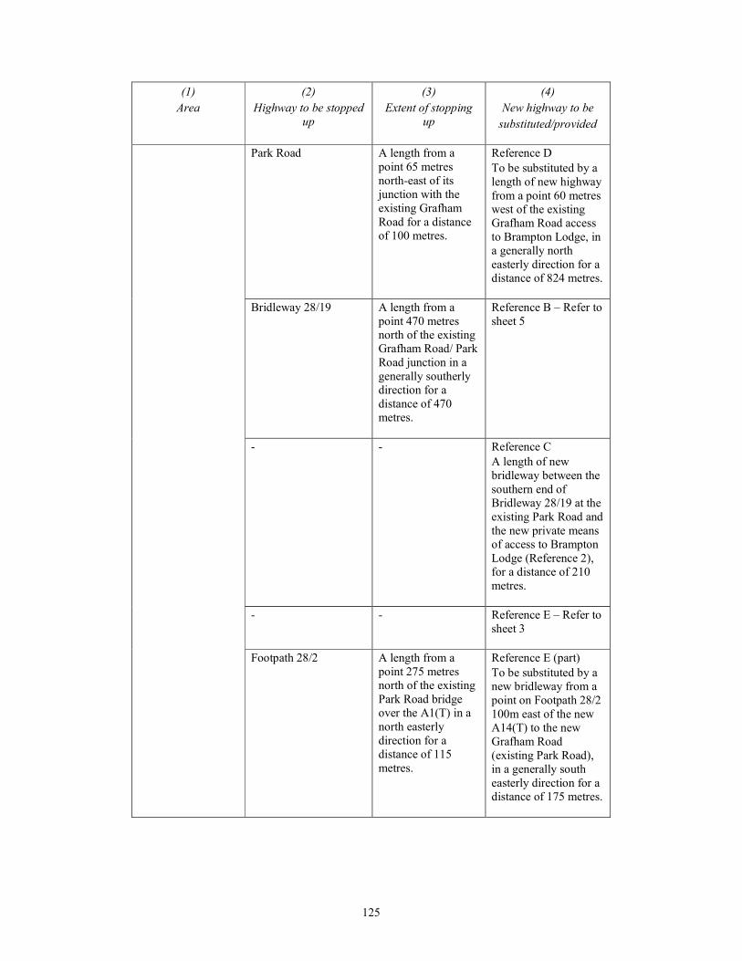
125
(1)
Area
(2)
Highway to be stopped
up
(3)
Extent of stopping
up
(4)
New highway to be
substituted/provided
Park Road A length from a
point 65 metres
north-east of its
junction with the
existing Grafham
Road for a distance
of 100 metres.
Reference D
To be substituted by a
length of new highway
from a point 60 metres
west of the existing
Grafham Road access
to Brampton Lodge, in
a generally north
easterly direction for a
distance of 824 metres.
Bridleway 28/19 A length from a
point 470 metres
north of the existing
Grafham Road/ Park
Road junction in a
generally southerly
direction for a
distance of 470
metres.
Reference B – Refer to
sheet 5
- - Reference C
A length of new
bridleway between the
southern end of
Bridleway 28/19 at the
existing Park Road and
the new private means
of access to Brampton
Lodge (Reference 2),
for a distance of 210
metres.
- - Reference E – Refer to
sheet 3
Footpath 28/2 A length from a
point 275 metres
north of the existing
Park Road bridge
over the A1(T) in a
north easterly
direction for a
distance of 115
metres.
Reference E (part)
To be substituted by a
new bridleway from a
point on Footpath 28/2
100m east of the new
A14(T) to the new
Grafham Road
(existing Park Road),
in a generally south
easterly direction for a
distance of 175 metres.
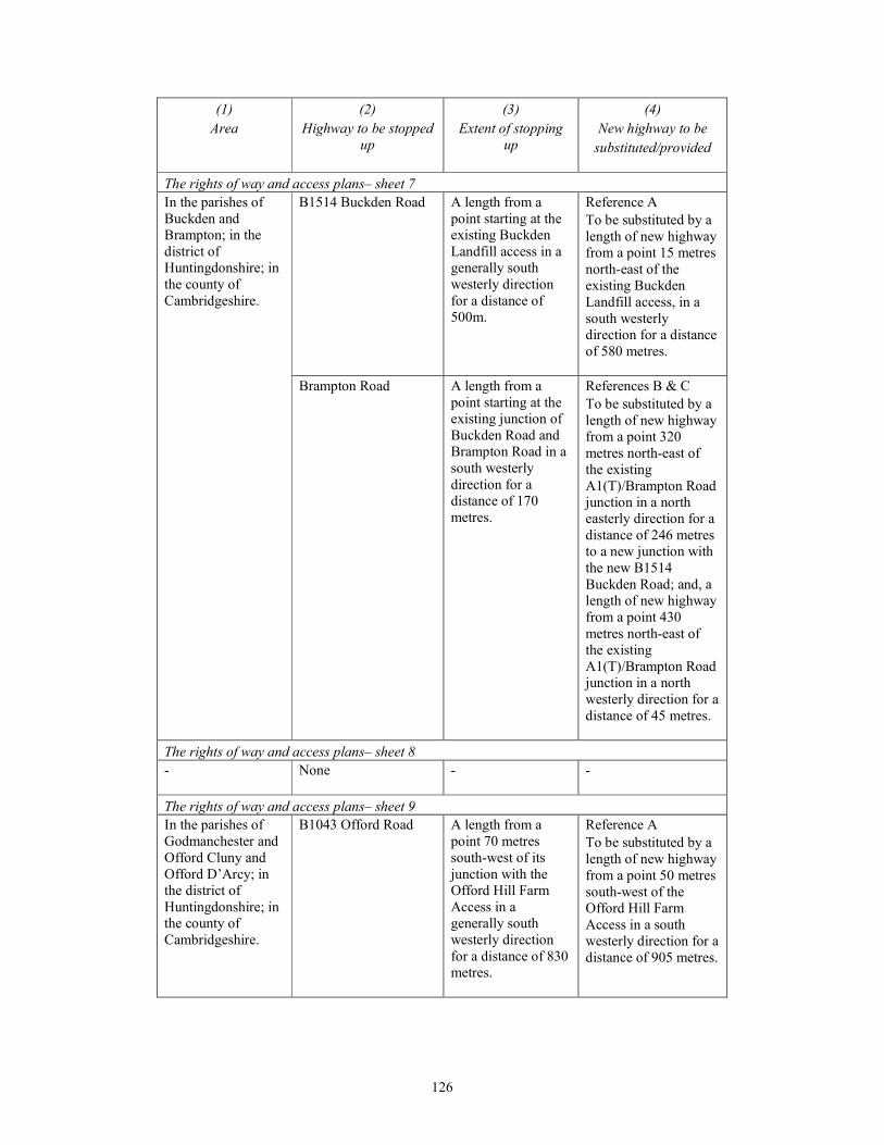
126
(1)
Area
(2)
Highway to be stopped
up
(3)
Extent of stopping
up
(4)
New highway to be
substituted/provided
The rights of way and access plans– sheet 7
In the parishes of
Buckden and
Brampton; in the
district of
Huntingdonshire; in
the county of
Cambridgeshire.
B1514 Buckden Road A length from a
point starting at the
existing Buckden
Landfill access in a
generally south
westerly direction
for a distance of
500m.
Reference A
To be substituted by a
length of new highway
from a point 15 metres
north-east of the
existing Buckden
Landfill access, in a
south westerly
direction for a distance
of 580 metres.
Brampton Road A length from a
point starting at the
existing junction of
Buckden Road and
Brampton Road in a
south westerly
direction for a
distance of 170
metres.
References B & C
To be substituted by a
length of new highway
from a point 320
metres north-east of
the existing
A1(T)/Brampton Road
junction in a north
easterly direction for a
distance of 246 metres
to a new junction with
the new B1514
Buckden Road; and, a
length of new highway
from a point 430
metres north-east of
the existing
A1(T)/Brampton Road
junction in a north
westerly direction for a
distance of 45 metres.
The rights of way and access plans– sheet 8
- None
- -
The rights of way and access plans– sheet 9
In the parishes of
Godmanchester and
Offord Cluny and
Offord D’Arcy; in
the district of
Huntingdonshire; in
the county of
Cambridgeshire.
B1043 Offord Road A length from a
point 70 metres
south-west of its
junction with the
Offord Hill Farm
Access in a
generally south
westerly direction
for a distance of 830
metres.
Reference A
To be substituted by a
length of new highway
from a point 50 metres
south-west of the
Offord Hill Farm
Access in a south
westerly direction for a
distance of 905 metres.

127
(1)
Area
(2)
Highway to be stopped
up
(3)
Extent of stopping
up
(4)
New highway to be
substituted/provided
The rights of way and access plans– sheet 10
In the parish of
Godmanchester; in
the district of
Huntingdonshire; in
the county of
Cambridgeshire.
Silver Street A length from a
point 80 metres
south of its junction
with the Lower
Debden Farm
Access in a
southerly direction
for a distance of
340m.
Reference A
To be substituted by a
length of new highway
from a point 55 metres
south of its junction
with the Lower
Debden Farm Access
in a southerly direction
for a distance of 460
metres.
The rights of way and access plans– sheet 11
In the parishes of
Godmanchester and
Hemingford
Abbotts; in the
district of
Huntingdonshire; in
the county of
Cambridgeshire.
A1198 Ermine Street A length from a
point 250 metres
south-east of its
junction with the
Beacon Field Equine
Centre Access in a
south easterly
direction for a
distance of 390m.
Reference A
To be substituted by a
length of new highway
from a point 220
metres south-east of
the Beacon Field
Equine Centre Access
in a south easterly
direction for a distance
of 660 metres.
The rights of way and access plans– sheet 12
In the parishes of
Hemingford Abbotts
and Hemingford
Grey; in the district
of Huntingdonshire;
in the county of
Cambridgeshire.
Bridleway 121/10 A length from a
point 510 metres
west of its junction
with Mere Way in a
generally westerly
direction for a
distance of 570
metres.
Reference A
To be substituted by a
new bridleway on the
south side of the new
A14(T) between the
start and end points of
the stopping up, for a
distance of 470 metres.
Bridleway 121/10 A length from its
junction with Mere
Way in a westerly
direction for a
distance of 30
metres.
Reference B
To be substituted by a
length of new
bridleway adjacent to
Mere Way in a
southerly direction, for
a distance of 100
metres, to a junction
with Bridleway
122/13.
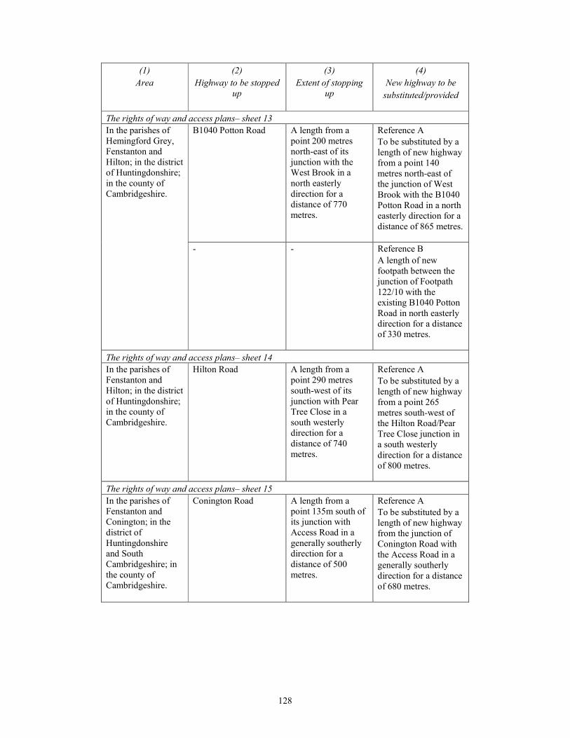
128
(1)
Area
(2)
Highway to be stopped
up
(3)
Extent of stopping
up
(4)
New highway to be
substituted/provided
The rights of way and access plans– sheet 13
In the parishes of
Hemingford Grey,
Fenstanton and
Hilton; in the district
of Huntingdonshire;
in the county of
Cambridgeshire.
B1040 Potton Road A length from a
point 200 metres
north-east of its
junction with the
West Brook in a
north easterly
direction for a
distance of 770
metres.
Reference A
To be substituted by a
length of new highway
from a point 140
metres north-east of
the junction of West
Brook with the B1040
Potton Road in a north
easterly direction for a
distance of 865 metres.
- - Reference B
A length of new
footpath between the
junction of Footpath
122/10 with the
existing B1040 Potton
Road in north easterly
direction for a distance
of 330 metres.
The rights of way and access plans– sheet 14
In the parishes of
Fenstanton and
Hilton; in the district
of Huntingdonshire;
in the county of
Cambridgeshire.
Hilton Road A length from a
point 290 metres
south-west of its
junction with Pear
Tree Close in a
south westerly
direction for a
distance of 740
metres.
Reference A
To be substituted by a
length of new highway
from a point 265
metres south-west of
the Hilton Road/Pear
Tree Close junction in
a south westerly
direction for a distance
of 800 metres.
The rights of way and access plans– sheet 15
In the parishes of
Fenstanton and
Conington; in the
district of
Huntingdonshire
and South
Cambridgeshire; in
the county of
Cambridgeshire.
Conington Road A length from a
point 135m south of
its junction with
Access Road in a
generally southerly
direction for a
distance of 500
metres.
Reference A
To be substituted by a
length of new highway
from the junction of
Conington Road with
the Access Road in a
generally southerly
direction for a distance
of 680 metres.

129
(1)
Area
(2)
Highway to be stopped
up
(3)
Extent of stopping
up
(4)
New highway to be
substituted/provided
- - Reference B
A length of new
footpath running in a
north-westerly
direction adjacent to
the northern boundary
of the existing
Conington Road and
then the new realigned
Conington Road for a
distance of 515 metres
and joining the
highway boundary of
the realigned
Conington Road at a
point adjacent to the
new private means of
access (Reference 4).
Footpath 87/14 and
Footpath 53/1
A length of Footpath
87/14 from its
junction with
Footpath 87/6, south
eastward to its
junction with
Footpath 53/1 at the
Fenstanton Parish
boundary, a distance
of 430 metres. In
addition, a length of
Footpath 53/1 from
its junction with
Footpath 87/14 at
the Fenstanton
Parish boundary,
southward to its
junction with
Conington Road, a
distance of 530
metres.
To be substituted by
the existing Footpath
87/6 from its junction
with Footpath 87/14 to
Access Road, a new
footway along Access
Road to the junction
with the new
Conington Road, a
new footway along the
new Conington Road
(part Reference A),
and new Footpath
(Reference B) to its
junction with Footpath
53/1.

130
(1)
Area
(2)
Highway to be stopped
up
(3)
Extent of stopping
up
(4)
New highway to be
substituted/provided
Footpath 53/2 A length from its
junction with New
Barns Lane, north
eastward to its
junction with
Huntingdon Road, a
distance of 895
metres.
To be substituted by a
new footpath
(Reference C), a
footway along the
north side of New
Barns Lane (sheet 16)
and footways along
Huntingdon Road
(A14) north-westward
to its junction with
Footpath 53/2 (sheets
15 and 16).
The rights of way and access plans– sheet 16
In the parishes of
Fen Drayton and
Conington; in the
district of South
Cambridgeshire; in
the county of
Cambridgeshire.
- - Reference C – Refer to
sheet 15
The rights of way and access plans– sheet 17
In the parishes of
Swavesey,
Conington and
Boxworth; in the
district of South
Cambridgeshire; in
the county of
Cambridgeshire.
Bucking Way Road A length from a
point 150 metres
north-west of the
Cambridge Services
roundabout, north-
eastward for 76
metres; and a length
from its junction
with the A14
northward for a
distance of 40
metres.
References B, C and D
(part)
To be substituted by a
length of new highway
from the Anderson
Road/Bucking Way
Road junction, south
westward to the
southern dumbbell
roundabout of the new
Swavesey Junction
then south eastward for
a total distance of 1255
metres, to the
Cambridge Services
roundabout.
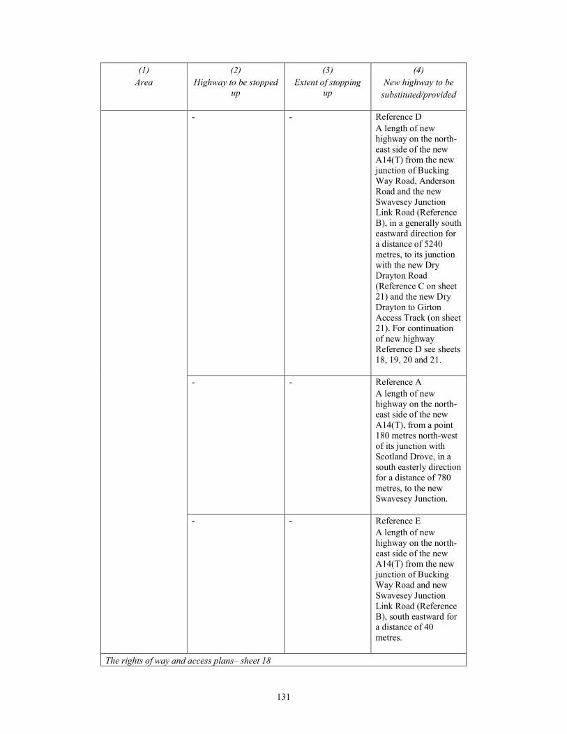
131
(1)
Area
(2)
Highway to be stopped
up
(3)
Extent of stopping
up
(4)
New highway to be
substituted/provided
- - Reference D
A length of new
highway on the north-
east side of the new
A14(T) from the new
junction of Bucking
Way Road, Anderson
Road and the new
Swavesey Junction
Link Road (Reference
B), in a generally south
eastward direction for
a distance of 5240
metres, to its junction
with the new Dry
Drayton Road
(Reference C on sheet
21) and the new Dry
Drayton to Girton
Access Track (on sheet
21). For continuation
of new highway
Reference D see sheets
18, 19, 20 and 21.
- - Reference A
A length of new
highway on the north-
east side of the new
A14(T), from a point
180 metres north-west
of its junction with
Scotland Drove, in a
south easterly direction
for a distance of 780
metres, to the new
Swavesey Junction.
- - Reference E
A length of new
highway on the north-
east side of the new
A14(T) from the new
junction of Bucking
Way Road and new
Swavesey Junction
Link Road (Reference
B), south eastward for
a distance of 40
metres.
The rights of way and access plans– sheet 18
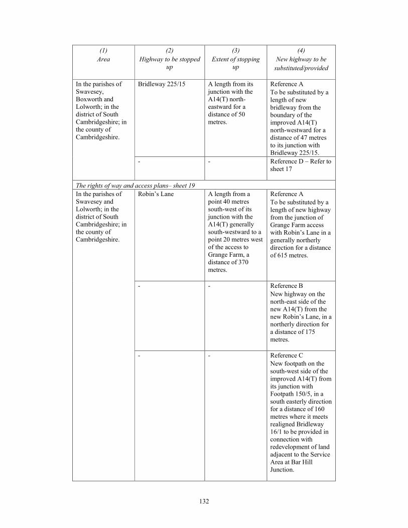
132
(1)
Area
(2)
Highway to be stopped
up
(3)
Extent of stopping
up
(4)
New highway to be
substituted/provided
In the parishes of
Swavesey,
Boxworth and
Lolworth; in the
district of South
Cambridgeshire; in
the county of
Cambridgeshire.
Bridleway 225/15 A length from its
junction with the
A14(T) north-
eastward for a
distance of 50
metres.
Reference A
To be substituted by a
length of new
bridleway from the
boundary of the
improved A14(T)
north-westward for a
distance of 47 metres
to its junction with
Bridleway 225/15.
- - Reference D – Refer to
sheet 17
The rights of way and access plans– sheet 19
In the parishes of
Swavesey and
Lolworth; in the
district of South
Cambridgeshire; in
the county of
Cambridgeshire.
Robin’s Lane A length from a
point 40 metres
south-west of its
junction with the
A14(T) generally
south-westward to a
point 20 metres west
of the access to
Grange Farm, a
distance of 370
metres.
Reference A
To be substituted by a
length of new highway
from the junction of
Grange Farm access
with Robin’s Lane in a
generally northerly
direction for a distance
of 615 metres.
- - Reference B
New highway on the
north-east side of the
new A14(T) from the
new Robin’s Lane, in a
northerly direction for
a distance of 175
metres.
- - Reference C
New footpath on the
south-west side of the
improved A14(T) from
its junction with
Footpath 150/5, in a
south easterly direction
for a distance of 160
metres where it meets
realigned Bridleway
16/1 to be provided in
connection with
redevelopment of land
adjacent to the Service
Area at Bar Hill
Junction.
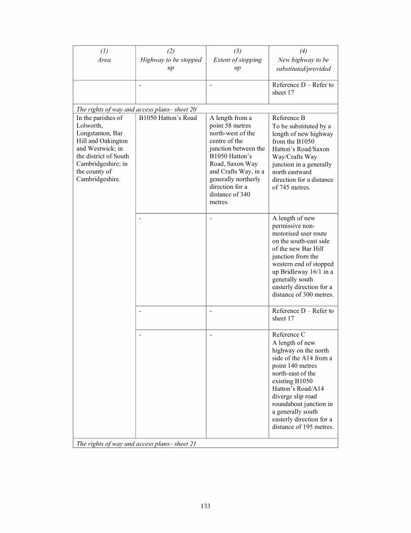
133
(1)
Area
(2)
Highway to be stopped
up
(3)
Extent of stopping
up
(4)
New highway to be
substituted/provided
- - Reference D – Refer to
sheet 17
The rights of way and access plans– sheet 20
In the parishes of
Lolworth,
Longstanton, Bar
Hill and Oakington
and Westwick; in
the district of South
Cambridgeshire; in
the county of
Cambridgeshire.
B1050 Hatton’s Road A length from a
point 58 metres
north-west of the
centre of the
junction between the
B1050 Hatton’s
Road, Saxon Way
and Crafts Way, in a
generally northerly
direction for a
distance of 340
metres.
Reference B
To be substituted by a
length of new highway
from the B1050
Hatton’s Road/Saxon
Way/Crafts Way
junction in a generally
north eastward
direction for a distance
of 745 metres.
- - A length of new
permissive non-
motorised user route
on the south-east side
of the new Bar Hill
junction from the
western end of stopped
up Bridleway 16/1 in a
generally south
easterly direction for a
distance of 300 metres.
- - Reference D – Refer to
sheet 17
- - Reference C
A length of new
highway on the north
side of the A14 from a
point 140 metres
north-east of the
existing B1050
Hatton’s Road/A14
diverge slip road
roundabout junction in
a generally south
easterly direction for a
distance of 195 metres.
The rights of way and access plans– sheet 21
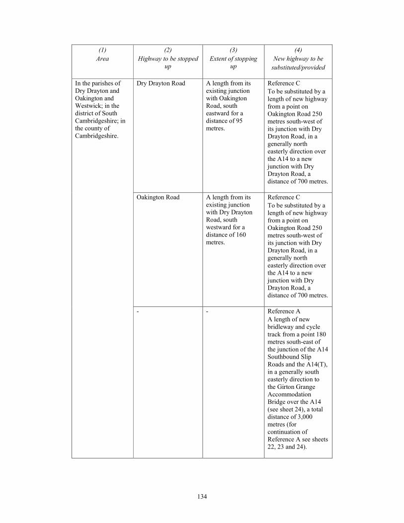
134
(1)
Area
(2)
Highway to be stopped
up
(3)
Extent of stopping
up
(4)
New highway to be
substituted/provided
In the parishes of
Dry Drayton and
Oakington and
Westwick; in the
district of South
Cambridgeshire; in
the county of
Cambridgeshire.
Dry Drayton Road A length from its
existing junction
with Oakington
Road, south
eastward for a
distance of 95
metres.
Reference C
To be substituted by a
length of new highway
from a point on
Oakington Road 250
metres south-west of
its junction with Dry
Drayton Road, in a
generally north
easterly direction over
the A14 to a new
junction with Dry
Drayton Road, a
distance of 700 metres.
Oakington Road A length from its
existing junction
with Dry Drayton
Road, south
westward for a
distance of 160
metres.
Reference C
To be substituted by a
length of new highway
from a point on
Oakington Road 250
metres south-west of
its junction with Dry
Drayton Road, in a
generally north
easterly direction over
the A14 to a new
junction with Dry
Drayton Road, a
distance of 700 metres.
- - Reference A
A length of new
bridleway and cycle
track from a point 180
metres south-east of
the junction of the A14
Southbound Slip
Roads and the A14(T),
in a generally south
easterly direction to
the Girton Grange
Accommodation
Bridge over the A14
(see sheet 24), a total
distance of 3,000
metres (for
continuation of
Reference A see sheets
22, 23 and 24).
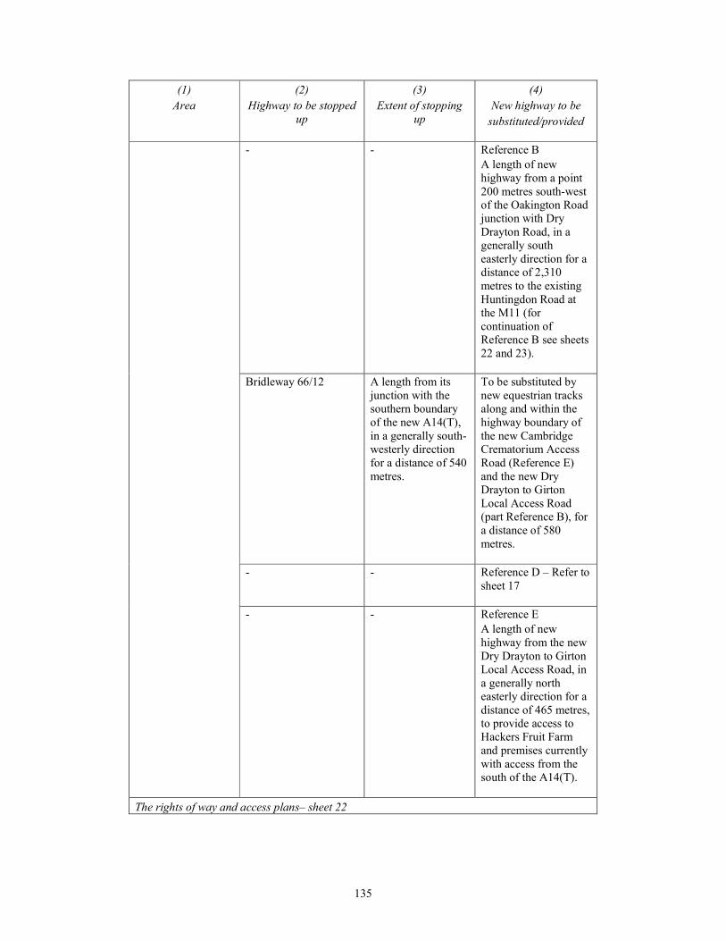
135
(1)
Area
(2)
Highway to be stopped
up
(3)
Extent of stopping
up
(4)
New highway to be
substituted/provided
- - Reference B
A length of new
highway from a point
200 metres south-west
of the Oakington Road
junction with Dry
Drayton Road, in a
generally south
easterly direction for a
distance of 2,310
metres to the existing
Huntingdon Road at
the M11 (for
continuation of
Reference B see sheets
22 and 23).
Bridleway 66/12 A length from its
junction with the
southern boundary
of the new A14(T),
in a generally south-
westerly direction
for a distance of 540
metres.
To be substituted by
new equestrian tracks
along and within the
highway boundary of
the new Cambridge
Crematorium Access
Road (Reference E)
and the new Dry
Drayton to Girton
Local Access Road
(part Reference B), for
a distance of 580
metres.
- - Reference D – Refer to
sheet 17
- - Reference E
A length of new
highway from the new
Dry Drayton to Girton
Local Access Road, in
a generally north
easterly direction for a
distance of 465 metres,
to provide access to
Hackers Fruit Farm
and premises currently
with access from the
south of the A14(T).
The rights of way and access plans– sheet 22
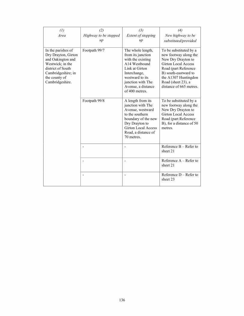
136
(1)
Area
(2)
Highway to be stopped
up
(3)
Extent of stopping
up
(4)
New highway to be
substituted/provided
In the parishes of
Dry Drayton, Girton
and Oakington and
Westwick; in the
district of South
Cambridgeshire; in
the county of
Cambridgeshire.
Footpath 99/7 The whole length,
from its junction
with the existing
A14 Westbound
Link at Girton
Interchange,
westward to its
junction with The
Avenue, a distance
of 400 metres.
To be substituted by a
new footway along the
New Dry Drayton to
Girton Local Access
Road (part Reference
B) south-eastward to
the A1307 Huntingdon
Road (sheet 23), a
distance of 665 metres.
Footpath 99/8 A length from its
junction with The
Avenue, westward
to the southern
boundary of the new
Dry Drayton to
Girton Local Access
Road, a distance of
70 metres.
To be substituted by a
new footway along the
New Dry Drayton to
Girton Local Access
Road (part Reference
B), for a distance of 50
metres.
- - Reference B – Refer to
sheet 21
- - Reference A – Refer to
sheet 21
- - Reference D – Refer to
sheet 23
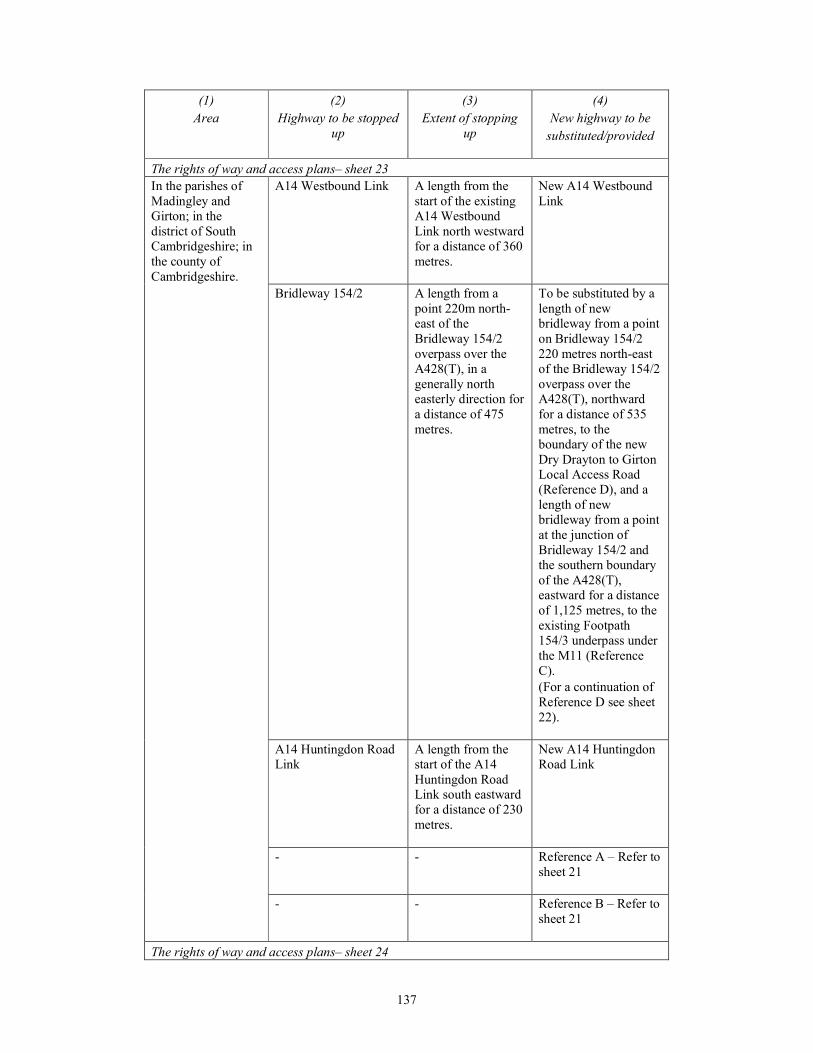
137
(1)
Area
(2)
Highway to be stopped
up
(3)
Extent of stopping
up
(4)
New highway to be
substituted/provided
The rights of way and access plans– sheet 23
In the parishes of
Madingley and
Girton; in the
district of South
Cambridgeshire; in
the county of
Cambridgeshire.
A14 Westbound Link A length from the
start of the existing
A14 Westbound
Link north westward
for a distance of 360
metres.
New A14 Westbound
Link
Bridleway 154/2 A length from a
point 220m north-
east of the
Bridleway 154/2
overpass over the
A428(T), in a
generally north
easterly direction for
a distance of 475
metres.
To be substituted by a
length of new
bridleway from a point
on Bridleway 154/2
220 metres north-east
of the Bridleway 154/2
overpass over the
A428(T), northward
for a distance of 535
metres, to the
boundary of the new
Dry Drayton to Girton
Local Access Road
(Reference D), and a
length of new
bridleway from a point
at the junction of
Bridleway 154/2 and
the southern boundary
of the A428(T),
eastward for a distance
of 1,125 metres, to the
existing Footpath
154/3 underpass under
the M11 (Reference
C).
(For a continuation of
Reference D see sheet
22).
A14 Huntingdon Road
Link
A length from the
start of the A14
Huntingdon Road
Link south eastward
for a distance of 230
metres.
New A14 Huntingdon
Road Link
- - Reference A – Refer to
sheet 21
- - Reference B – Refer to
sheet 21
The rights of way and access plans– sheet 24
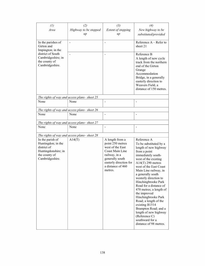
138
(1)
Area
(2)
Highway to be stopped
up
(3)
Extent of stopping
up
(4)
New highway to be
substituted/provided
In the parishes of
Girton and
Impington; in the
district of South
Cambridgeshire; in
the county of
Cambridgeshire.
- - Reference A – Refer to
sheet 21
- - Reference B
A length of new cycle
track from the northern
end of the Girton
Grange
Accommodation
Bridge, in a generally
easterly direction to
Weavers Field, a
distance of 150 metres.
The rights of way and access plans– sheet 25
None
None - -
The rights of way and access plans– sheet 26
None
None - -
The rights of way and access plans– sheet 27
None
None - -
The rights of way and access plans– sheet 28
In the parish of
Huntingdon; in the
district of
Huntingdonshire; in
the county of
Cambridgeshire.
A14(T) A length from a
point 250 metres
west of the East
Coast Main Line
railway, in a
generally south
easterly direction for
a distance of 460
metres.
Reference A
To be substituted by a
length of new highway
from a point
immediately south-
west of the existing
A14(T) 290 metres
west of the East Coast
Main Line railway, in
a generally south
westerly direction to
Hinchingbrooke Park
Road for a distance of
470 metres; a length of
the improved
Hinchingbrooke Park
Road; a length of the
existing B1514
Brampton Road; and a
length of new highway
(Reference C)
southward for a
distance of 98 metres.
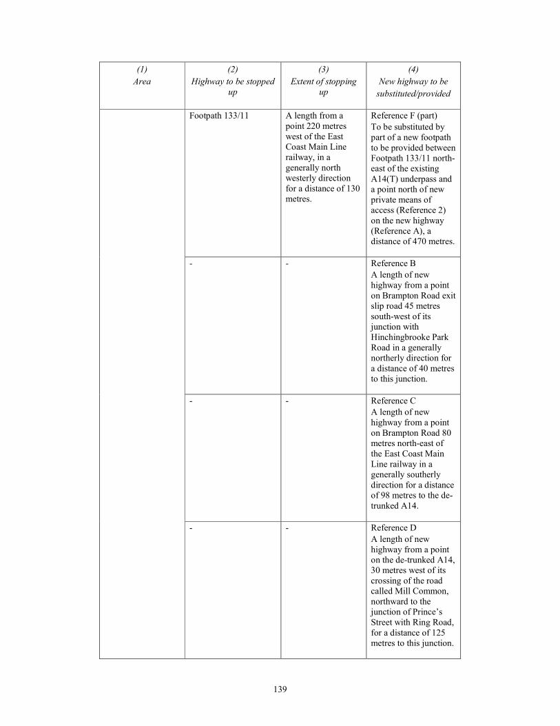
139
(1)
Area
(2)
Highway to be stopped
up
(3)
Extent of stopping
up
(4)
New highway to be
substituted/provided
Footpath 133/11 A length from a
point 220 metres
west of the East
Coast Main Line
railway, in a
generally north
westerly direction
for a distance of 130
metres.
Reference F (part)
To be substituted by
part of a new footpath
to be provided between
Footpath 133/11 north-
east of the existing
A14(T) underpass and
a point north of new
private means of
access (Reference 2)
on the new highway
(Reference A), a
distance of 470 metres.
- - Reference B
A length of new
highway from a point
on Brampton Road exit
slip road 45 metres
south-west of its
junction with
Hinchingbrooke Park
Road in a generally
northerly direction for
a distance of 40 metres
to this junction.
- - Reference C
A length of new
highway from a point
on Brampton Road 80
metres north-east of
the East Coast Main
Line railway in a
generally southerly
direction for a distance
of 98 metres to the de-
trunked A14.
- - Reference D
A length of new
highway from a point
on the de-trunked A14,
30 metres west of its
crossing of the road
called Mill Common,
northward to the
junction of Prince’s
Street with Ring Road,
for a distance of 125
metres to this junction.

140
(1)
Area
(2)
Highway to be stopped
up
(3)
Extent of stopping
up
(4)
New highway to be
substituted/provided
- - Reference E
A length of new
highway from a point
on Ring Road 45
metres south-east of its
junction with Prince’s
Street in a generally
southerly direction for
a distance of 50 metres
to the road called Mill
Common.
- - Reference G
A length of new cycle
track from a point
north of new private
means of access
(Reference 2) on the
new highway
(Reference A), in a
north-easterly direction
for a distance of 290
metres to a junction
with Footpath 133/11.

141
PART 2
HIGHWAYS TO BE STOPPED UP FOR WHICH NO SUBSTITUTE IS TO BE
PROVIDED
(1)
Area
(2)
Street to be stopped up
(3)
Extent of stopping up
The rights of way and access plans– sheet 1
None
None -
The rights of way and access plans– sheet 2
In the parishes of
Alconbury and The
Stukeleys; in the
district of
Huntingdonshire; in
the county of
Cambridgeshire.
Layby east of the improved A1(T)
365m south of the existing A1(T)
junction with Woolley Road.
The whole layby.
Bridleway 230/6
A length from its junction
with the A1(T), 700 metres
south of the existing A1(T)
junction with Woolley Road,
in a easterly direction to the
new highway boundary, a
distance of 10 metres.
The rights of way and access plans– sheet 3
None
None -
The rights of way and access plans– sheet 4
None
None -
The rights of way and access plans– sheet 5
None
None -
The rights of way and access plans– sheet 6
None
None -
The rights of way and access plans– sheet 7
None
None -
The rights of way and access plans– sheet 8
None
None -
The rights of way and access plans– sheet 9
None
None -
The rights of way and access plans– sheet 10
None
None -
The rights of way and access plans– sheet 11
None
None -
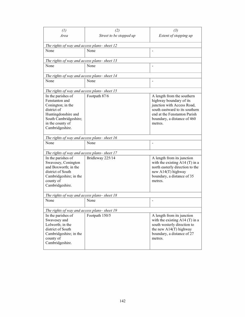
142
(1)
Area
(2)
Street to be stopped up
(3)
Extent of stopping up
The rights of way and access plans– sheet 12
None
None -
The rights of way and access plans– sheet 13
None
None -
The rights of way and access plans– sheet 14
None
None -
The rights of way and access plans– sheet 15
In the parishes of
Fenstanton and
Conington; in the
district of
Huntingdonshire and
South Cambridgeshire;
in the county of
Cambridgeshire.
Footpath 87/6 A length from the southern
highway boundary of its
junction with Access Road,
south eastward to its southern
end at the Fenstanton Parish
boundary, a distance of 460
metres.
The rights of way and access plans– sheet 16
None
None -
The rights of way and access plans– sheet 17
In the parishes of
Swavesey, Conington
and Boxworth; in the
district of South
Cambridgeshire; in the
county of
Cambridgeshire.
Bridleway 225/14 A length from its junction
with the existing A14 (T) in a
north easterly direction to the
new A14(T) highway
boundary, a distance of 35
metres.
The rights of way and access plans– sheet 18
None
None -
The rights of way and access plans– sheet 19
In the parishes of
Swavesey and
Lolworth; in the
district of South
Cambridgeshire; in the
county of
Cambridgeshire.
Footpath 150/5 A length from its junction
with the existing A14 (T) in a
south westerly direction to
the new A14(T) highway
boundary, a distance of 27
metres.

143
(1)
Area
(2)
Street to be stopped up
(3)
Extent of stopping up
The rights of way and access plans– sheet 20
In the parishes of
Lolworth,
Longstanton, Bar Hill
and Oakington and
Westwick; in the
district of South
Cambridgeshire; in the
county of
Cambridgeshire.
Bridleway 151/10 A length from its junction
with the A14(T), in a north-
easterly direction to the
north-east highway boundary
of the new Local Access
Road (Swavesey Junction /
Dry Drayton Local Access
Road), a distance of 85
metres.
Bridleway 16/1 A length from its junction
with the A14(T), in a
generally north-westerly
direction for a distance of 145
metres.
The rights of way and access plans– sheet 21
In the parishes of Dry
Drayton and
Oakington and
Westwick; in the
district of South
Cambridgeshire; in the
county of
Cambridgeshire.
A14 Southbound slip roads
The whole slip road.
A14 Northbound slip roads The whole slip road.
The rights of way and access plans– sheet 22
In the parishes of Dry
Drayton, Girton and
Oakington and
Westwick; in the
district of South
Cambridgeshire; in the
county of
Cambridgeshire.
The Avenue A length from a point 43
metres south-west of its
junction with the A14(T),
south-westward for a distance
of 220 metres.
The rights of way and access plans– sheet 23
In the parishes of
Madingley and Girton;
in the district of South
Cambridgeshire; in the
county of
Cambridgeshire.
Washpit Lane A length from its junction
with the A14(T), north
eastward for a distance of 55
metres.
Bridleway 99/6 A length from the western
highway boundary of the
existing A14 Westbound
Link, in a north easterly
direction to and beyond the
A1307 Huntingdon Road, for
a total distance of 260 metres.
The rights of way and access plans– sheet 24
None
None -
144
(1)
Area
(2)
Street to be stopped up
(3)
Extent of stopping up
The rights of way and access plans– sheet 25
None
None -
The rights of way and access plans– sheet 26
None
None -
The rights of way and access plans– sheet 27
None
None -
The rights of way and access plans– sheet 28
None
None -
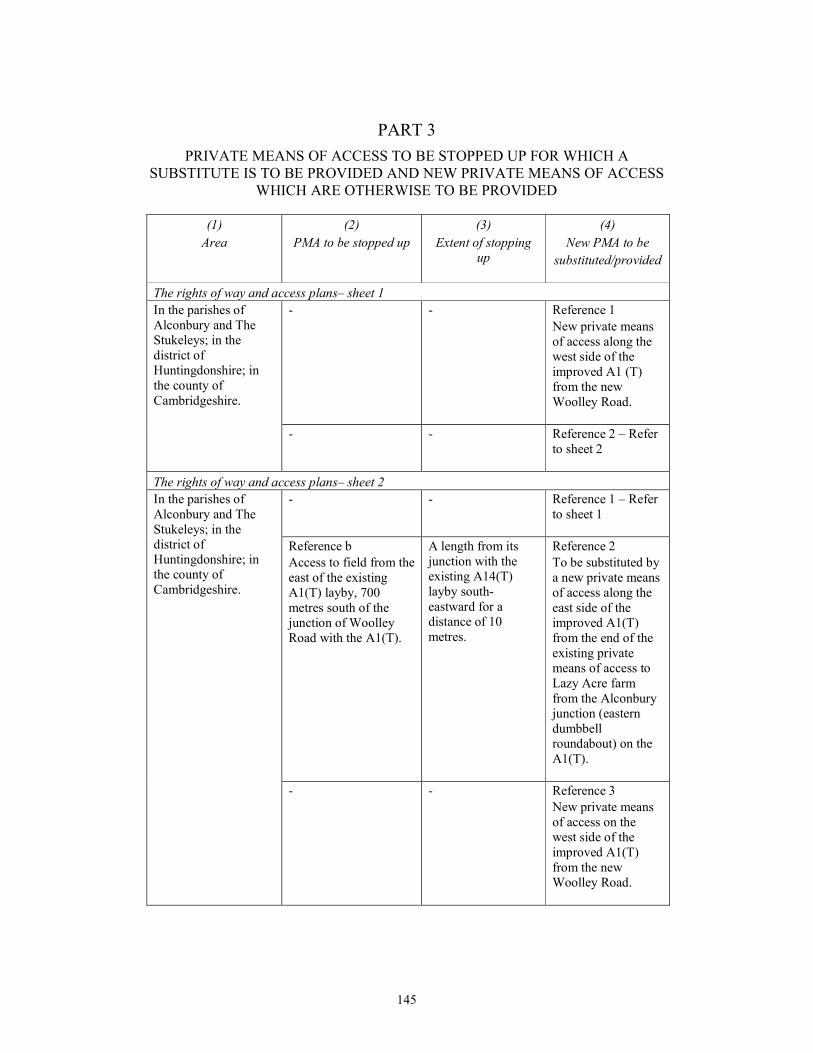
145
PART 3
PRIVATE MEANS OF ACCESS TO BE STOPPED UP FOR WHICH A
SUBSTITUTE IS TO BE PROVIDED AND NEW PRIVATE MEANS OF ACCESS
WHICH ARE OTHERWISE TO BE PROVIDED
(1)
Area
(2)
PMA to be stopped up
(3)
Extent of stopping
up
(4)
New PMA to be
substituted/provided
The rights of way and access plans– sheet 1
In the parishes of
Alconbury and The
Stukeleys; in the
district of
Huntingdonshire; in
the county of
Cambridgeshire.
- - Reference 1
New private means
of access along the
west side of the
improved A1 (T)
from the new
Woolley Road.
- - Reference 2 – Refer
to sheet 2
The rights of way and access plans– sheet 2
In the parishes of
Alconbury and The
Stukeleys; in the
district of
Huntingdonshire; in
the county of
Cambridgeshire.
- - Reference 1 – Refer
to sheet 1
Reference b
Access to field from the
east of the existing
A1(T) layby, 700
metres south of the
junction of Woolley
Road with the A1(T).
A length from its
junction with the
existing A14(T)
layby south-
eastward for a
distance of 10
metres.
Reference 2
To be substituted by
a new private means
of access along the
east side of the
improved A1(T)
from the end of the
existing private
means of access to
Lazy Acre farm
from the Alconbury
junction (eastern
dumbbell
roundabout) on the
A1(T).
- - Reference 3
New private means
of access on the
west side of the
improved A1(T)
from the new
Woolley Road.
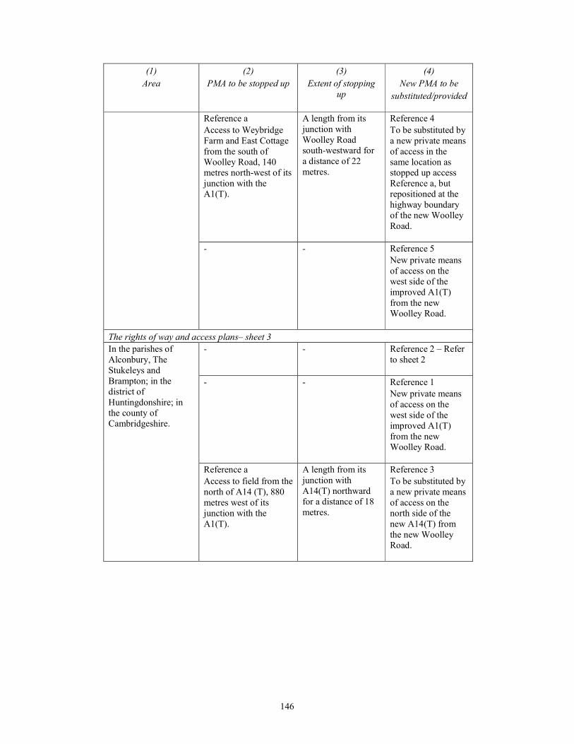
146
(1)
Area
(2)
PMA to be stopped up
(3)
Extent of stopping
up
(4)
New PMA to be
substituted/provided
Reference a
Access to Weybridge
Farm and East Cottage
from the south of
Woolley Road, 140
metres north-west of its
junction with the
A1(T).
A length from its
junction with
Woolley Road
south-westward for
a distance of 22
metres.
Reference 4
To be substituted by
a new private means
of access in the
same location as
stopped up access
Reference a, but
repositioned at the
highway boundary
of the new Woolley
Road.
- - Reference 5
New private means
of access on the
west side of the
improved A1(T)
from the new
Woolley Road.
The rights of way and access plans– sheet 3
In the parishes of
Alconbury, The
Stukeleys and
Brampton; in the
district of
Huntingdonshire; in
the county of
Cambridgeshire.
- - Reference 2 – Refer
to sheet 2
- - Reference 1
New private means
of access on the
west side of the
improved A1(T)
from the new
Woolley Road.
Reference a
Access to field from the
north of A14 (T), 880
metres west of its
junction with the
A1(T).
A length from its
junction with
A14(T) northward
for a distance of 18
metres.
Reference 3
To be substituted by
a new private means
of access on the
north side of the
new A14(T) from
the new Woolley
Road.
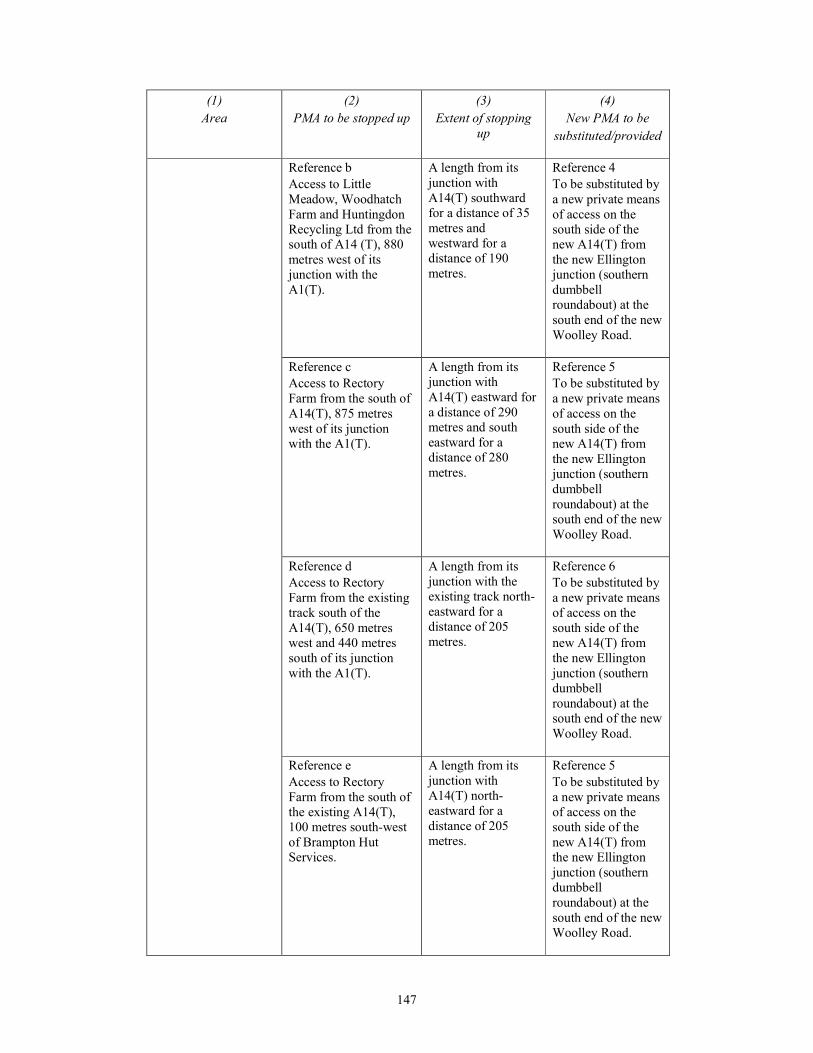
147
(1)
Area
(2)
PMA to be stopped up
(3)
Extent of stopping
up
(4)
New PMA to be
substituted/provided
Reference b
Access to Little
Meadow, Woodhatch
Farm and Huntingdon
Recycling Ltd from the
south of A14 (T), 880
metres west of its
junction with the
A1(T).
A length from its
junction with
A14(T) southward
for a distance of 35
metres and
westward for a
distance of 190
metres.
Reference 4
To be substituted by
a new private means
of access on the
south side of the
new A14(T) from
the new Ellington
junction (southern
dumbbell
roundabout) at the
south end of the new
Woolley Road.
Reference c
Access to Rectory
Farm from the south of
A14(T), 875 metres
west of its junction
with the A1(T).
A length from its
junction with
A14(T) eastward for
a distance of 290
metres and south
eastward for a
distance of 280
metres.
Reference 5
To be substituted by
a new private means
of access on the
south side of the
new A14(T) from
the new Ellington
junction (southern
dumbbell
roundabout) at the
south end of the new
Woolley Road.
Reference d
Access to Rectory
Farm from the existing
track south of the
A14(T), 650 metres
west and 440 metres
south of its junction
with the A1(T).
A length from its
junction with the
existing track north-
eastward for a
distance of 205
metres.
Reference 6
To be substituted by
a new private means
of access on the
south side of the
new A14(T) from
the new Ellington
junction (southern
dumbbell
roundabout) at the
south end of the new
Woolley Road.
Reference e
Access to Rectory
Farm from the south of
the existing A14(T),
100 metres south-west
of Brampton Hut
Services.
A length from its
junction with
A14(T) north-
eastward for a
distance of 205
metres.
Reference 5
To be substituted by
a new private means
of access on the
south side of the
new A14(T) from
the new Ellington
junction (southern
dumbbell
roundabout) at the
south end of the new
Woolley Road.
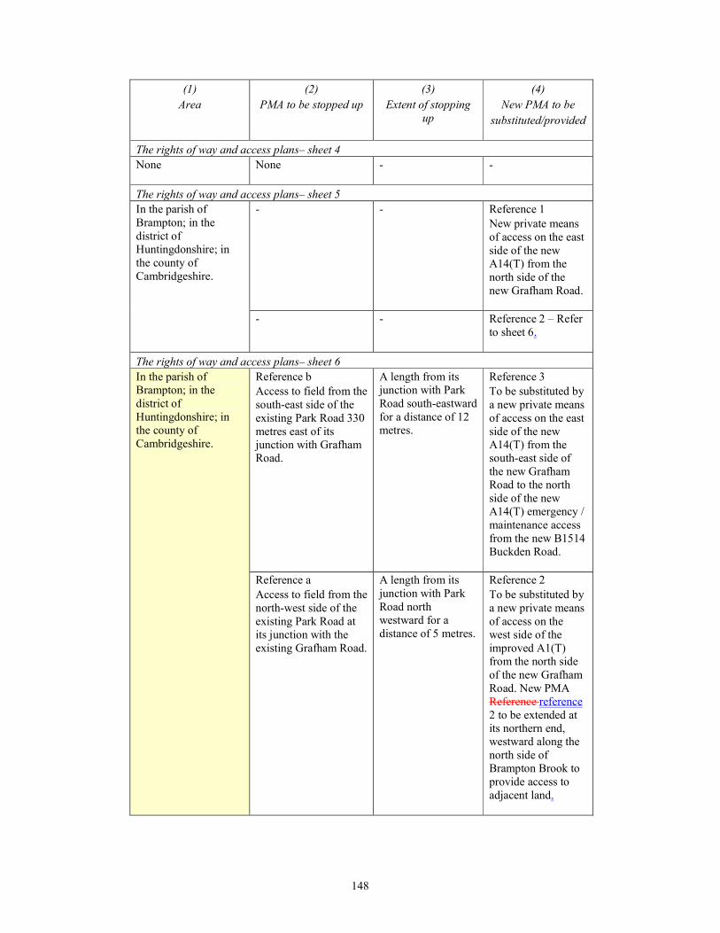
148
(1)
Area
(2)
PMA to be stopped up
(3)
Extent of stopping
up
(4)
New PMA to be
substituted/provided
The rights of way and access plans– sheet 4
None
None - -
The rights of way and access plans– sheet 5
In the parish of
Brampton; in the
district of
Huntingdonshire; in
the county of
Cambridgeshire.
- - Reference 1
New private means
of access on the east
side of the new
A14(T) from the
north side of the
new Grafham Road.
- - Reference 2 – Refer
to sheet 6.
The rights of way and access plans– sheet 6
In the parish of
Brampton; in the
district of
Huntingdonshire; in
the county of
Cambridgeshire.
Reference b
Access to field from the
south-east side of the
existing Park Road 330
metres east of its
junction with Grafham
Road.
A length from its
junction with Park
Road south-eastward
for a distance of 12
metres.
Reference 3
To be substituted by
a new private means
of access on the east
side of the new
A14(T) from the
south-east side of
the new Grafham
Road to the north
side of the new
A14(T) emergency /
maintenance access
from the new B1514
Buckden Road.
Reference a
Access to field from the
north-west side of the
existing Park Road at
its junction with the
existing Grafham Road.
A length from its
junction with Park
Road north
westward for a
distance of 5 metres.
Reference 2
To be substituted by
a new private means
of access on the
west side of the
improved A1(T)
from the north side
of the new Grafham
Road. New PMA
Reference reference
2 to be extended at
its northern end,
westward along the
north side of
Brampton Brook to
provide access to
adjacent land.
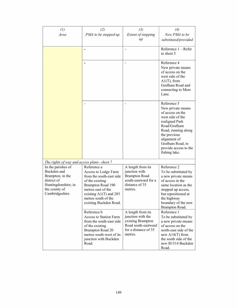
149
(1)
Area
(2)
PMA to be stopped up
(3)
Extent of stopping
up
(4)
New PMA to be
substituted/provided
- - Reference 1 – Refer
to sheet 5
- - Reference 4
New private means
of access on the
west side of the
A1(T), from
Grafham Road and
connecting to Mere
Lane.
- - Reference 5
New private means
of access on the
west side of the
realigned Park
Road/Grafham
Road, running along
the previous
alignment of
Grafham Road, to
provide access to the
fishing lake.
The rights of way and access plans– sheet 7
In the parishes of
Buckden and
Brampton; in the
district of
Huntingdonshire; in
the county of
Cambridgeshire.
Reference a
Access to Lodge Farm
from the south-east side
of the existing
Brampton Road 190
metres east of the
existing A1(T) and 285
metres south of the
existing Buckden Road.
A length from its
junction with
Brampton Road
south-eastward for a
distance of 35
metres.
Reference 2
To be substituted by
a new private means
of access in the
same location as the
stopped up access,
but repositioned at
the highway
boundary of the new
Brampton Road.
Reference b
Access to Station Farm
from the south-east side
of the existing
Brampton Road 20
metres south-west of its
junction with Buckden
Road.
A length from its
junction with the
existing Brampton
Road south-eastward
for a distance of 35
metres.
Reference 1
To be substituted by
a new private means
of access on the
north-east side of the
new A14(T) from
the south side of the
new B1514 Buckden
Road.

150
(1)
Area
(2)
PMA to be stopped up
(3)
Extent of stopping
up
(4)
New PMA to be
substituted/provided
Reference c
Access to Station Farm
from the south-east side
of the existing
Brampton Road 10
metres south-west of its
junction with Buckden
Road.
A length from its
junction with the
existing Brampton
Road south-eastward
for a distance of 7
metres.
Reference 1
To be substituted by
a new private means
of access on the
north-east side of the
new A14(T) from
the south side of the
new B1514 Buckden
Road.
Reference d
Access to field from the
north-west side of the
existing Buckden Road
15 metres south-west of
the existing access to
the Landfill site.
A length from its
junction with the
existing Buckden
Road north-
westward for a
distance of 30
metres.
Reference 3
To be substituted by
a new private means
of access on the east
side of the improved
A1(T) from the
south-east side of
the new Grafham
Road to the north
side of the new
A14(T) emergency /
maintenance access
from the new B1514
Buckden Road.
- - Reference 6
New private means
of access
commencing on the
north-east side of the
new A14(T) from
the access to Station
Farm, continuing
south-eastward then
south- westward
around the new
A14(T) embankment
to connect with the
access to Lodge
Farm (on sheet 7).

151
(1)
Area
(2)
PMA to be stopped up
(3)
Extent of stopping
up
(4)
New PMA to be
substituted/provided
The rights of way and access plans– sheet 8
In the parishes of
Buckden,
Godmanchester and
Offord, Cluny and
D’Arcy; in the district
of Huntingdonshire; in
the county of
Cambridgeshire.
- - Reference 1
New private means
of access on the
north-east and
south-west sides of
the new A14(T)
from the existing
track south of the
new A14(T).
- - Reference 3
New private means
of access on the
north and south
sides of the new
A14(T) from the
south-east side of
the existing access
track.
- - Reference 4
New private means
of access on the
north and south
sides of the new
A14(T) from the
west side of the
B1043 Offord Road
at Corpus Christi
Farm.
- - Reference 5
New private means
of access on the
south side of the
new A14(T) from
the west side of the
new B1043 Offord
Road.
- - Reference 6 – Refer
to sheet 7
The rights of way and access plans– sheet 9
In the parishes of
Godmanchester and
- - Reference 5 – Refer
to sheet 8
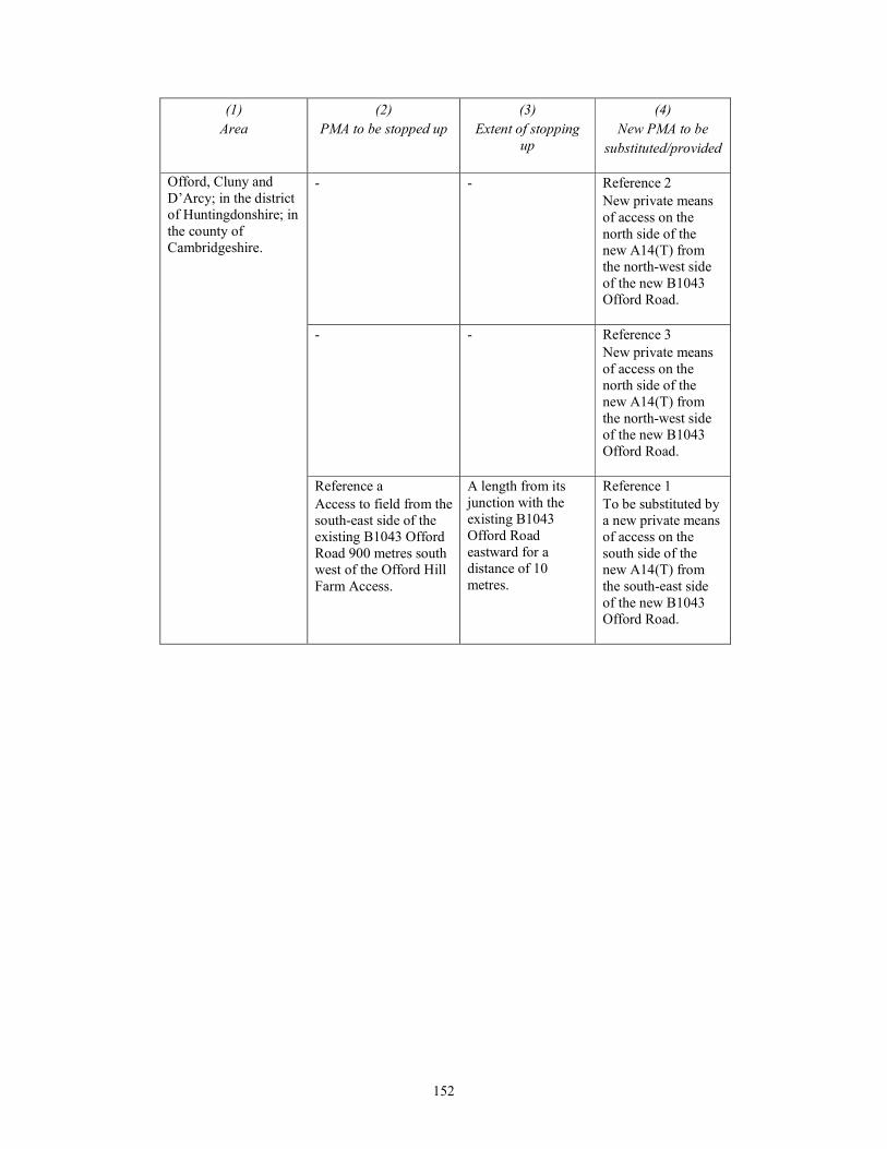
152
(1)
Area
(2)
PMA to be stopped up
(3)
Extent of stopping
up
(4)
New PMA to be
substituted/provided
Offord, Cluny and
D’Arcy; in the district
of Huntingdonshire; in
the county of
Cambridgeshire.
- - Reference 2
New private means
of access on the
north side of the
new A14(T) from
the north-west side
of the new B1043
Offord Road.
- - Reference 3
New private means
of access on the
north side of the
new A14(T) from
the north-west side
of the new B1043
Offord Road.
Reference a
Access to field from the
south-east side of the
existing B1043 Offord
Road 900 metres south
west of the Offord Hill
Farm Access.
A length from its
junction with the
existing B1043
Offord Road
eastward for a
distance of 10
metres.
Reference 1
To be substituted by
a new private means
of access on the
south side of the
new A14(T) from
the south-east side
of the new B1043
Offord Road.
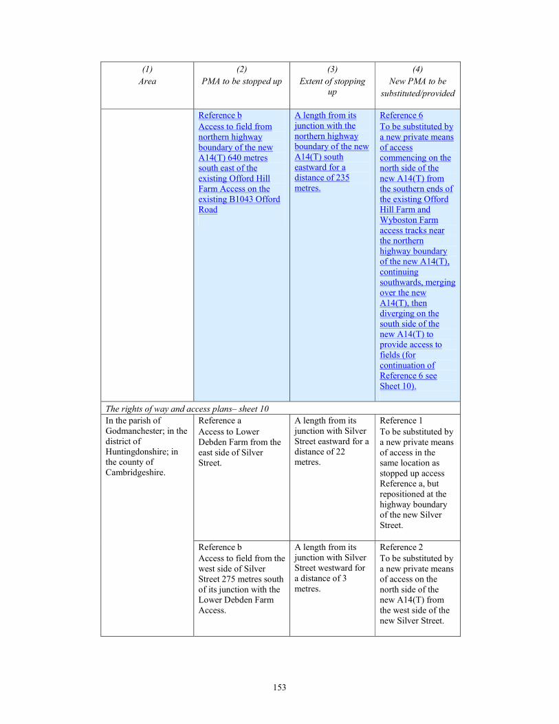
153
(1)
Area
(2)
PMA to be stopped up
(3)
Extent of stopping
up
(4)
New PMA to be
substituted/provided
Reference b
Access to field from
northern highway
boundary of the new
A14(T) 640 metres
south east of the
existing Offord Hill
Farm Access on the
existing B1043 Offord
Road
A length from its
junction with the
northern highway
boundary of the new
A14(T) south
eastward for a
distance of 235
metres.
Reference 6
To be substituted by
a new private means
of access
commencing on the
north side of the
new A14(T) from
the southern ends of
the existing Offord
Hill Farm and
Wyboston Farm
access tracks near
the northern
highway boundary
of the new A14(T),
continuing
southwards, merging
over the new
A14(T), then
diverging on the
south side of the
new A14(T) to
provide access to
fields (for
continuation of
Reference 6 see
Sheet 10).
The rights of way and access plans– sheet 10
In the parish of
Godmanchester; in the
district of
Huntingdonshire; in
the county of
Cambridgeshire.
Reference a
Access to Lower
Debden Farm from the
east side of Silver
Street.
A length from its
junction with Silver
Street eastward for a
distance of 22
metres.
Reference 1
To be substituted by
a new private means
of access in the
same location as
stopped up access
Reference a, but
repositioned at the
highway boundary
of the new Silver
Street.
Reference b
Access to field from the
west side of Silver
Street 275 metres south
of its junction with the
Lower Debden Farm
Access.
A length from its
junction with Silver
Street westward for
a distance of 3
metres.
Reference 2
To be substituted by
a new private means
of access on the
north side of the
new A14(T) from
the west side of the
new Silver Street.
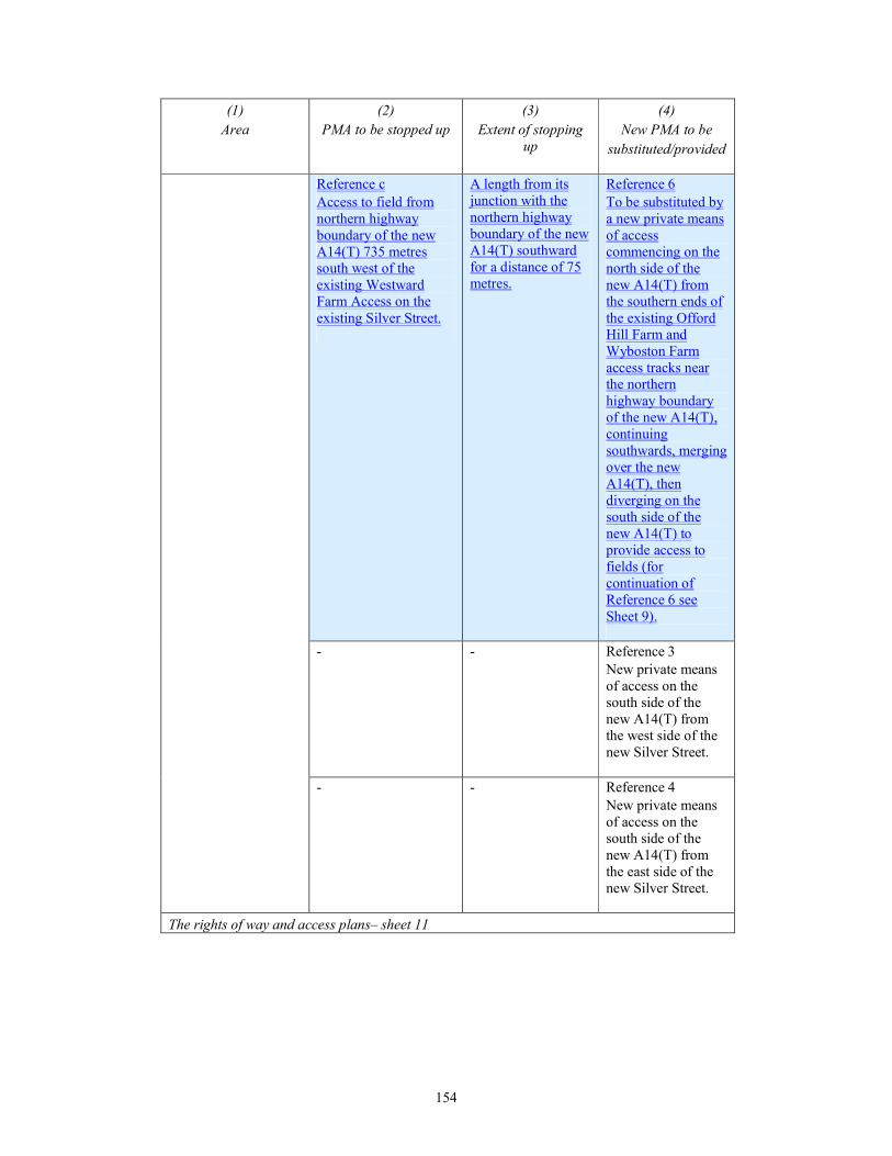
154
(1)
Area
(2)
PMA to be stopped up
(3)
Extent of stopping
up
(4)
New PMA to be
substituted/provided
Reference c
Access to field from
northern highway
boundary of the new
A14(T) 735 metres
south west of the
existing Westward
Farm Access on the
existing Silver Street.
A length from its
junction with the
northern highway
boundary of the new
A14(T) southward
for a distance of 75
metres.
Reference 6
To be substituted by
a new private means
of access
commencing on the
north side of the
new A14(T) from
the southern ends of
the existing Offord
Hill Farm and
Wyboston Farm
access tracks near
the northern
highway boundary
of the new A14(T),
continuing
southwards, merging
over the new
A14(T), then
diverging on the
south side of the
new A14(T) to
provide access to
fields (for
continuation of
Reference 6 see
Sheet 9).
- - Reference 3
New private means
of access on the
south side of the
new A14(T) from
the west side of the
new Silver Street.
- - Reference 4
New private means
of access on the
south side of the
new A14(T) from
the east side of the
new Silver Street.
The rights of way and access plans– sheet 11
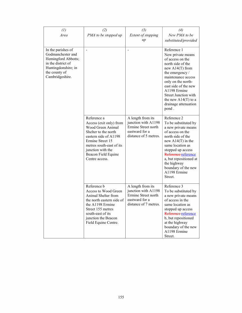
155
(1)
Area
(2)
PMA to be stopped up
(3)
Extent of stopping
up
(4)
New PMA to be
substituted/provided
In the parishes of
Godmanchester and
Hemingford Abbotts;
in the district of
Huntingdonshire; in
the county of
Cambridgeshire.
- - Reference 1
New private means
of access on the
north side of the
new A14(T) from
the emergency /
maintenance access
only on the north-
east side of the new
A1198 Ermine
Street Junction with
the new A14(T) to a
drainage attenuation
pond .
Reference a
Access (exit only) from
Wood Green Animal
Shelter to the north
eastern side of A1198
Ermine Street 15
metres south-east of its
junction with the
Beacon Field Equine
Centre access.
A length from its
junction with A1198
Ermine Street north
eastward for a
distance of 5 metres.
Reference 2
To be substituted by
a new private means
of access on the
north side of the
new A14(T) in the
same location as
stopped up access
Reference reference
a, but repositioned at
the highway
boundary of the new
A1198 Ermine
Street.
Reference b
Access to Wood Green
Animal Shelter from
the north eastern side of
the A1198 Ermine
Street 155 metres
south-east of its
junction the Beacon
Field Equine Centre.
A length from its
junction with A1198
Ermine Street north
eastward for a
distance of 7 metres.
Reference 3
To be substituted by
a new private means
of access in the
same location as
stopped up access
Reference reference
b, but repositioned
at the highway
boundary of the new
A1198 Ermine
Street.
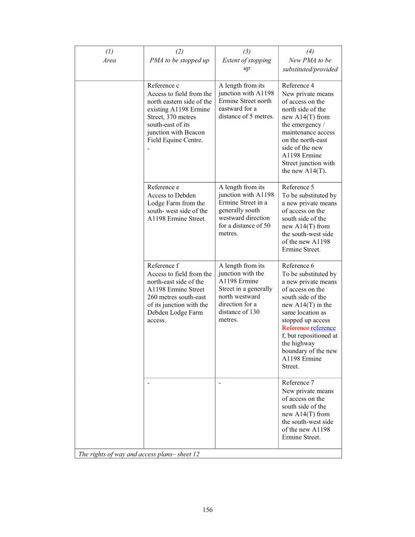
156
(1)
Area
(2)
PMA to be stopped up
(3)
Extent of stopping
up
(4)
New PMA to be
substituted/provided
Reference c
Access to field from the
north eastern side of the
existing A1198 Ermine
Street, 370 metres
south-east of its
junction with Beacon
Field Equine Centre.
-
A length from its
junction with A1198
Ermine Street north
eastward for a
distance of 5 metres.
Reference 4
New private means
of access on the
north side of the
new A14(T) from
the emergency /
maintenance access
on the north-east
side of the new
A1198 Ermine
Street junction with
the new A14(T).
Reference e
Access to Debden
Lodge Farm from the
south- west side of the
A1198 Ermine Street.
A length from its
junction with A1198
Ermine Street in a
generally south
westward direction
for a distance of 50
metres.
Reference 5
To be substituted by
a new private means
of access on the
south side of the
new A14(T) from
the south-west side
of the new A1198
Ermine Street.
Reference f
Access to field from the
north-east side of the
A1198 Ermine Street
260 metres south-east
of its junction with the
Debden Lodge Farm
access.
A length from its
junction with the
A1198 Ermine
Street in a generally
north westward
direction for a
distance of 130
metres.
Reference 6
To be substituted by
a new private means
of access on the
south side of the
new A14(T) in the
same location as
stopped up access
Reference reference
f, but repositioned at
the highway
boundary of the new
A1198 Ermine
Street.
- - Reference 7
New private means
of access on the
south side of the
new A14(T) from
the south-west side
of the new A1198
Ermine Street.
The rights of way and access plans– sheet 12
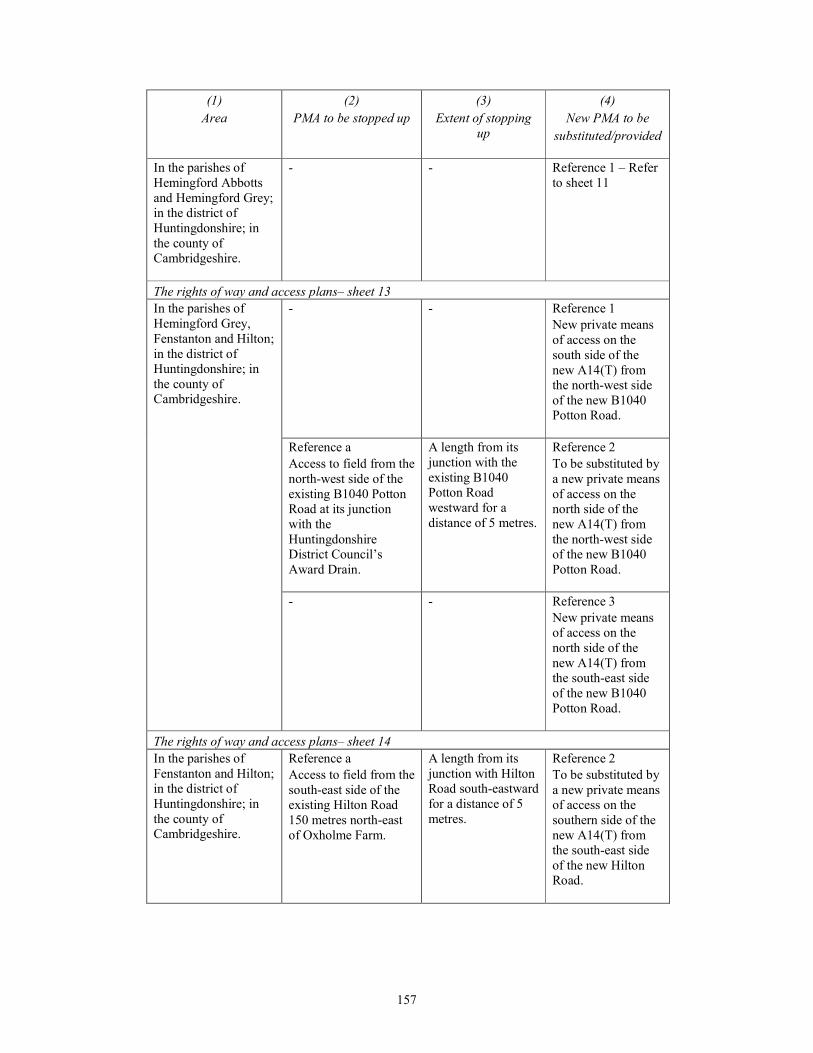
157
(1)
Area
(2)
PMA to be stopped up
(3)
Extent of stopping
up
(4)
New PMA to be
substituted/provided
In the parishes of
Hemingford Abbotts
and Hemingford Grey;
in the district of
Huntingdonshire; in
the county of
Cambridgeshire.
- - Reference 1 – Refer
to sheet 11
The rights of way and access plans– sheet 13
In the parishes of
Hemingford Grey,
Fenstanton and Hilton;
in the district of
Huntingdonshire; in
the county of
Cambridgeshire.
- - Reference 1
New private means
of access on the
south side of the
new A14(T) from
the north-west side
of the new B1040
Potton Road.
Reference a
Access to field from the
north-west side of the
existing B1040 Potton
Road at its junction
with the
Huntingdonshire
District Council’s
Award Drain.
A length from its
junction with the
existing B1040
Potton Road
westward for a
distance of 5 metres.
Reference 2
To be substituted by
a new private means
of access on the
north side of the
new A14(T) from
the north-west side
of the new B1040
Potton Road.
- - Reference 3
New private means
of access on the
north side of the
new A14(T) from
the south-east side
of the new B1040
Potton Road.
The rights of way and access plans– sheet 14
In the parishes of
Fenstanton and Hilton;
in the district of
Huntingdonshire; in
the county of
Cambridgeshire.
Reference a
Access to field from the
south-east side of the
existing Hilton Road
150 metres north-east
of Oxholme Farm.
A length from its
junction with Hilton
Road south-eastward
for a distance of 5
metres.
Reference 2
To be substituted by
a new private means
of access on the
southern side of the
new A14(T) from
the south-east side
of the new Hilton
Road.

158
(1)
Area
(2)
PMA to be stopped up
(3)
Extent of stopping
up
(4)
New PMA to be
substituted/provided
Reference b
Access to fields from
south-east side of the
existing Hilton Road
160 metres south-west
of Oxholme Farm.
A length from its
junction with Hilton
Road south-eastward
for a distance of 15
metres.
Reference 6
To be substituted by
a new private means
of access on the
south-east side of
the new Hilton Road
in the same location
as stopped up access
Reference b, but
repositioned at the
highway boundary
of the new Hilton
Road.
- - Reference 1
New private means
of access on the
south side of the
new A14(T) from
the north-west side
of the new Hilton
Road to Oxholme
Farm.
- - Reference 3
New private means
of access on the
north side of the
new A14(T) from
the north-west side
of the new Hilton
Road.
- - Reference 4
New private means
of access on the
north side of the
new A14(T) from
the south-east side
of the new Hilton
Road.
- - Reference 5
New private means
of access on the
north side of the
new A14(T) from
the south-east side
of the new Hilton
Road.
The rights of way and access plans– sheet 15

159
(1)
Area
(2)
PMA to be stopped up
(3)
Extent of stopping
up
(4)
New PMA to be
substituted/provided
In the parishes of
Fenstanton and
Conington; in the
district of
Huntingdonshire and
South
Cambridgeshire; in the
county of
Cambridgeshire.
Reference a
Access to field from the
north-east side of the
existing Conington
Road 750 metres south-
east of its junction with
Access Road.
A length from its
junction with
Conington Road in a
north eastward
direction for a
distance of 3 metres.
Reference 4
To be substituted by
a new private means
of access on the
south side of the
new A14(T) from
the north-east side of
the new Conington
Road.
Reference b
Access to field from the
south-west side of the
existing Conington
Road 750 metres south-
east of its junction with
Access Road.
A length from its
junction with
Conington Road in a
south westward
direction for a
distance of 5 metres.
Reference 5
To be substituted by
a new private means
of access on the
south side of the
new A14(T) from
the south-west side
of the new
Conington Road.
Reference c
Access to field from the
south-west side of the
existing Conington
Road 530 metres south
of its junction with
Access Road.
A length from its
junction with
Conington Road in a
south westward
direction for a
distance of 4 metres.
Reference 2
To be substituted by
a new private means
of access on the
south side of the
new A14(T) from
the west side of the
new Conington
Road to field,
drainage attenuation
pond and new
A14(T).
Reference d
Access to field from the
north side of the
existing New Barns
Lane 350 metres north-
east of its junction with
Conington Road.
A length from its
junction with New
Barns Lane in a
northerly direction
for a distance of 5
metres.
Reference 7
To be substituted by
a new private means
of access on the
south side of the
new A14(T) from
the north side of
New Barns Lane to
field and drainage
attenuation pond.
Reference e
Access to field from the
north-east side of
existing Conington
Road 170 metres south
of its junction with
Access Road.
A length from its
junction with
Conington Road in a
north easterly
direction for a
distance of 4 metres.
Reference 9
To be substituted by
a new private means
of access on the
south side of Access
Road at its junction
with the existing
Conington Road (to
be stopped up).
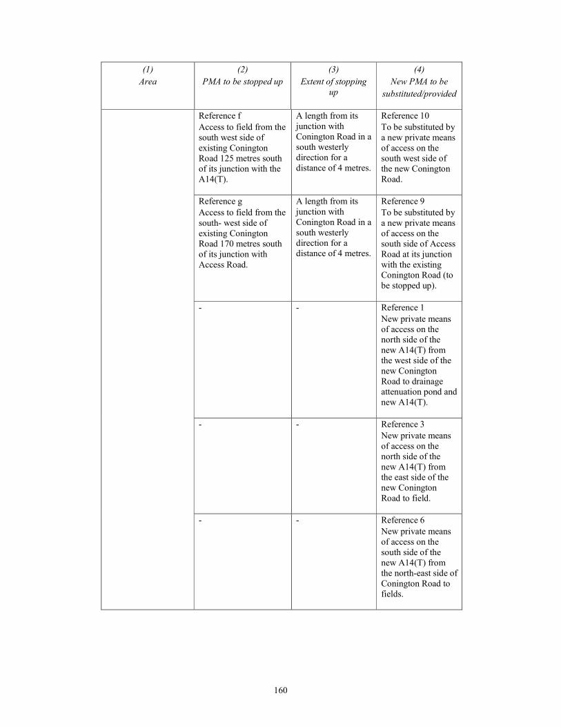
160
(1)
Area
(2)
PMA to be stopped up
(3)
Extent of stopping
up
(4)
New PMA to be
substituted/provided
Reference f
Access to field from the
south west side of
existing Conington
Road 125 metres south
of its junction with the
A14(T).
A length from its
junction with
Conington Road in a
south westerly
direction for a
distance of 4 metres.
Reference 10
To be substituted by
a new private means
of access on the
south west side of
the new Conington
Road.
Reference g
Access to field from the
south- west side of
existing Conington
Road 170 metres south
of its junction with
Access Road.
A length from its
junction with
Conington Road in a
south westerly
direction for a
distance of 4 metres.
Reference 9
To be substituted by
a new private means
of access on the
south side of Access
Road at its junction
with the existing
Conington Road (to
be stopped up).
- - Reference 1
New private means
of access on the
north side of the
new A14(T) from
the west side of the
new Conington
Road to drainage
attenuation pond and
new A14(T).
- - Reference 3
New private means
of access on the
north side of the
new A14(T) from
the east side of the
new Conington
Road to field.
- - Reference 6
New private means
of access on the
south side of the
new A14(T) from
the north-east side of
Conington Road to
fields.
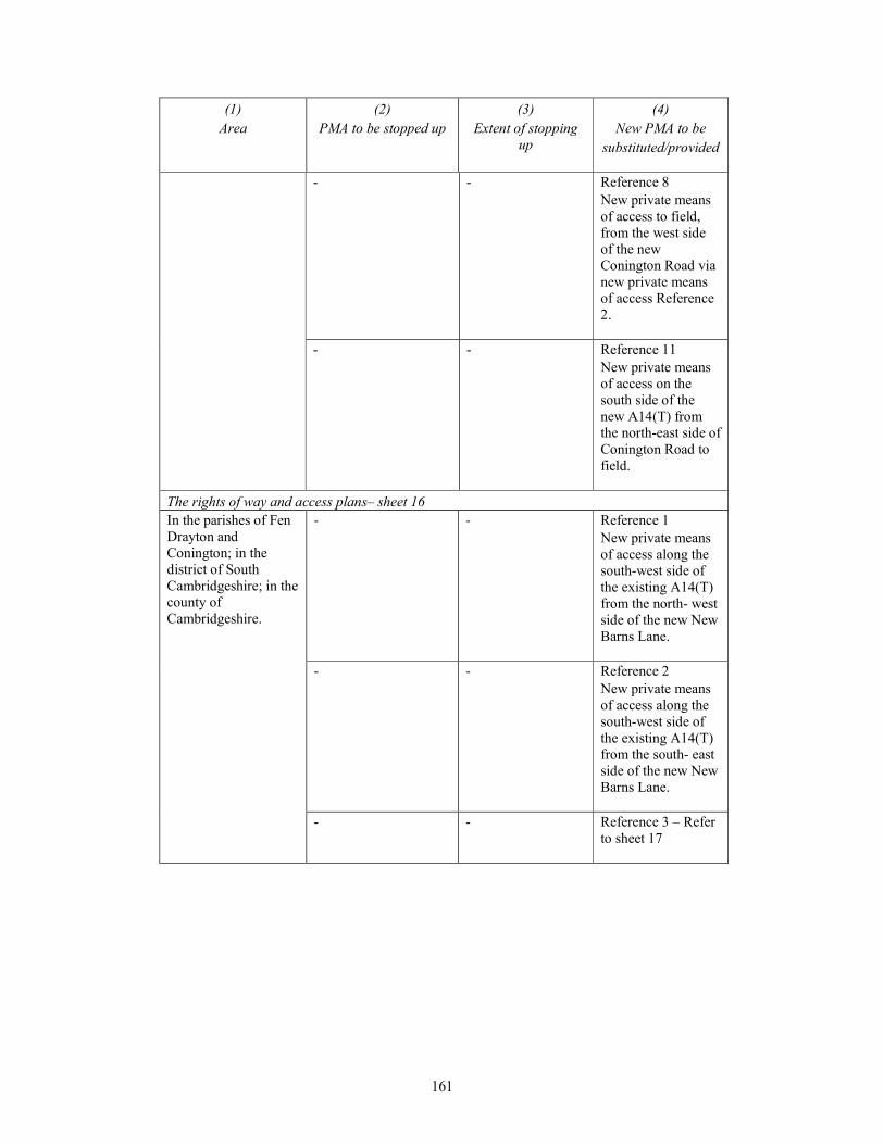
161
(1)
Area
(2)
PMA to be stopped up
(3)
Extent of stopping
up
(4)
New PMA to be
substituted/provided
- - Reference 8
New private means
of access to field,
from the west side
of the new
Conington Road via
new private means
of access Reference
2.
- - Reference 11
New private means
of access on the
south side of the
new A14(T) from
the north-east side of
Conington Road to
field.
The rights of way and access plans– sheet 16
In the parishes of Fen
Drayton and
Conington; in the
district of South
Cambridgeshire; in the
county of
Cambridgeshire.
- - Reference 1
New private means
of access along the
south-west side of
the existing A14(T)
from the north- west
side of the new New
Barns Lane.
- - Reference 2
New private means
of access along the
south-west side of
the existing A14(T)
from the south- east
side of the new New
Barns Lane.
- - Reference 3 – Refer
to sheet 17
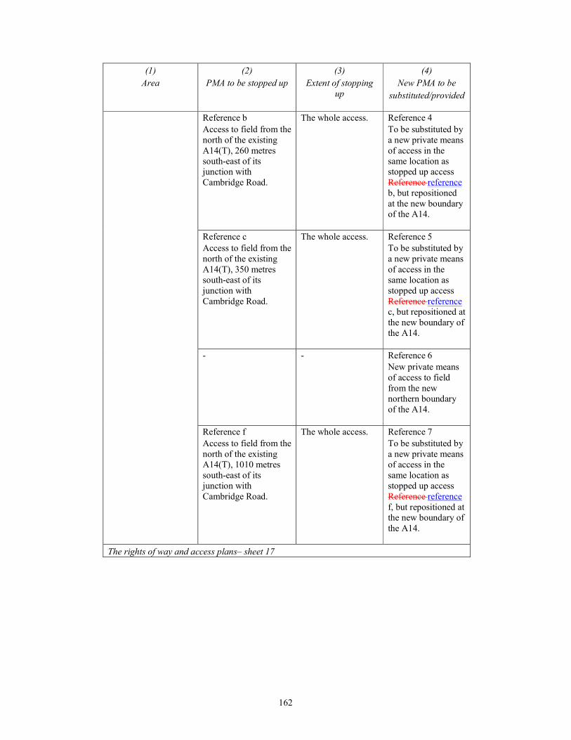
162
(1)
Area
(2)
PMA to be stopped up
(3)
Extent of stopping
up
(4)
New PMA to be
substituted/provided
Reference b
Access to field from the
north of the existing
A14(T), 260 metres
south-east of its
junction with
Cambridge Road.
The whole access. Reference 4
To be substituted by
a new private means
of access in the
same location as
stopped up access
Reference reference
b, but repositioned
at the new boundary
of the A14.
Reference c
Access to field from the
north of the existing
A14(T), 350 metres
south-east of its
junction with
Cambridge Road.
The whole access. Reference 5
To be substituted by
a new private means
of access in the
same location as
stopped up access
Reference reference
c, but repositioned at
the new boundary of
the A14.
- - Reference 6
New private means
of access to field
from the new
northern boundary
of the A14.
Reference f
Access to field from the
north of the existing
A14(T), 1010 metres
south-east of its
junction with
Cambridge Road.
The whole access. Reference 7
To be substituted by
a new private means
of access in the
same location as
stopped up access
Reference reference
f, but repositioned at
the new boundary of
the A14.
The rights of way and access plans– sheet 17
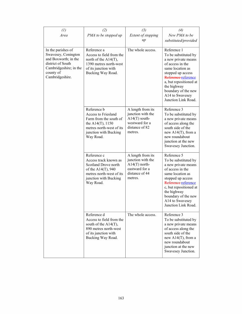
163
(1)
Area
(2)
PMA to be stopped up
(3)
Extent of stopping
up
(4)
New PMA to be
substituted/provided
In the parishes of
Swavesey, Conington
and Boxworth; in the
district of South
Cambridgeshire; in the
county of
Cambridgeshire.
Reference a
Access to field from the
north of the A14(T),
1390 metres north-west
of its junction with
Bucking Way Road.
The whole access. Reference 1
To be substituted by
a new private means
of access in the
same location as
stopped up access
Reference reference
a, but repositioned at
the highway
boundary of the new
A14 to Swavesey
Junction Link Road.
Reference b
Access to Friesland
Farm from the south of
the A14(T), 1150
metres north-west of its
junction with Bucking
Way Road.
A length from its
junction with the
A14(T) south-
westward for a
distance of 82
metres.
Reference 3
To be substituted by
a new private means
of access along the
south side of the
new A14(T), from a
new roundabout
junction at the new
Swavesey Junction.
Reference c
Access track known as
Scotland Drove north
of the A14(T), 940
metres north-west of its
junction with Bucking
Way Road.
A length from its
junction with the
A14(T) north-
eastward for a
distance of 44
metres.
Reference 5
To be substituted by
a new private means
of access in the
same location as
stopped up access
Reference reference
c, but repositioned at
the highway
boundary of the new
A14 to Swavesey
Junction Link Road.
Reference d
Access to field from the
south of the A14(T),
890 metres north-west
of its junction with
Bucking Way Road.
The whole access. Reference 3
To be substituted by
a new private means
of access along the
south side of the
new A14(T), from a
new roundabout
junction at the new
Swavesey Junction.
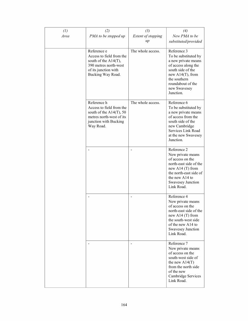
164
(1)
Area
(2)
PMA to be stopped up
(3)
Extent of stopping
up
(4)
New PMA to be
substituted/provided
Reference e
Access to field from the
south of the A14(T),
390 metres north-west
of its junction with
Bucking Way Road.
The whole access. Reference 3
To be substituted by
a new private means
of access along the
south side of the
new A14(T), from
the southern
roundabout of the
new Swavesey
Junction.
Reference h
Access to field from the
south of the A14(T), 50
metres north-west of its
junction with Bucking
Way Road.
The whole access. Reference 6
To be substituted by
a new private means
of access from the
south side of the
new Cambridge
Services Link Road
at the new Swavesey
Junction.
- - Reference 2
New private means
of access on the
north-east side of the
new A14 (T) from
the north-east side of
the new A14 to
Swavesey Junction
Link Road.
- - Reference 4
New private means
of access on the
north-east side of the
new A14 (T) from
the south-west side
of the new A14 to
Swavesey Junction
Link Road.
- - Reference 7
New private means
of access on the
south-west side of
the new A14(T)
from the north side
of the new
Cambridge Services
Link Road.

165
(1)
Area
(2)
PMA to be stopped up
(3)
Extent of stopping
up
(4)
New PMA to be
substituted/provided
- - Reference 8
New private means
of access on the
north-east side of the
new A14(T) from
the south-west side
of the improved
Bucking Way Road.
- - Reference 9
New private means
of access on the
south-west side of
the new A14(T)
from the north side
of the new
Cambridge Services
Link Road.
The rights of way and access plans– sheet 18
In the parishes of
Swavesey, Boxworth
and Lolworth; in the
district of South
Cambridgeshire; in the
county of
Cambridgeshire.
Reference a
Access to premises
from the north of the
A14(T), 690 metres
north-west of its
junction with the
Sewage Works access.
The whole access. Reference 1
To be substituted by
a new private means
of access in the
same location as
stopped up access
Reference reference
a, but repositioned at
the highway
boundary of the new
A14(T).
Reference b
Access to premises
from the north of the
A14(T), 682 metres
north-west of its
junction with the
Sewage Works access.
The whole access. Reference 2
To be substituted by
a new private means
of access in the
same location as
stopped up access
Reference reference
a, but repositioned at
the highway
boundary of the new
A14(T).
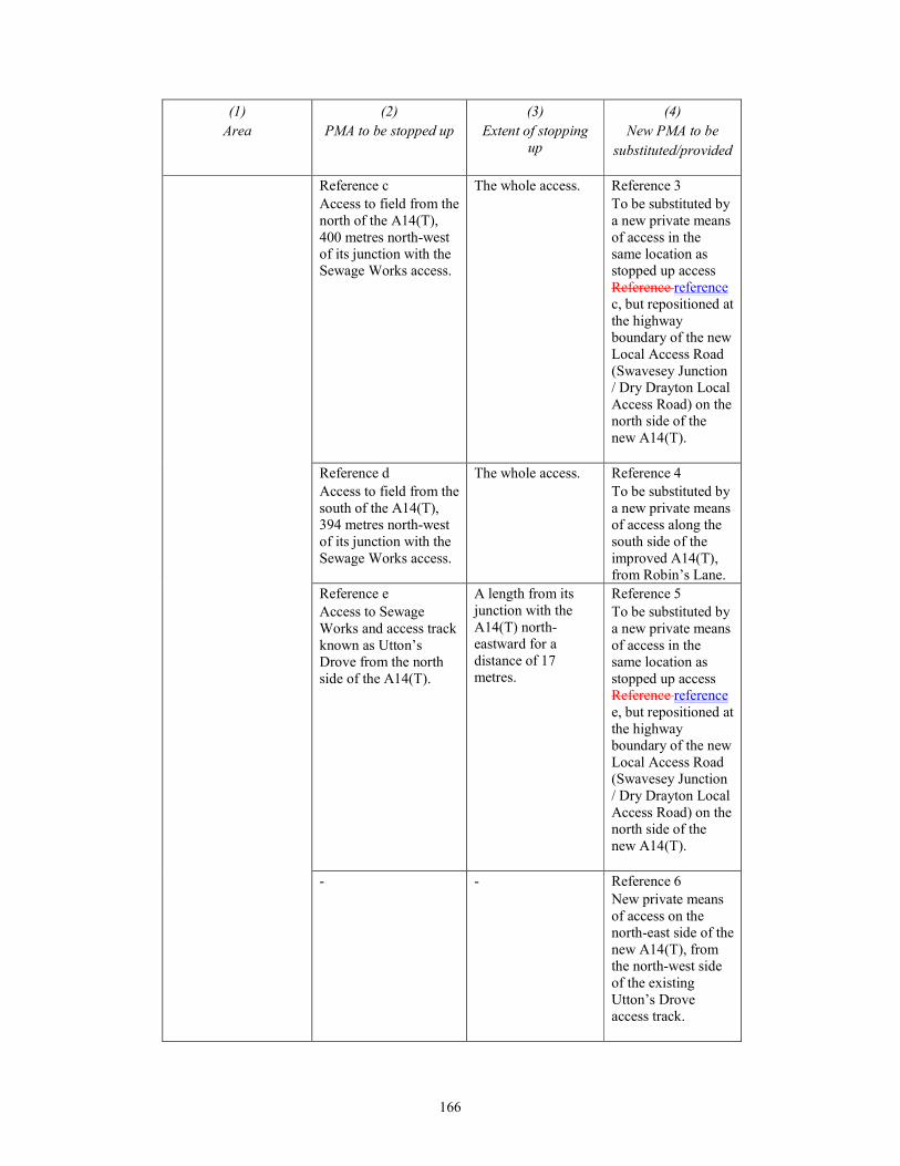
166
(1)
Area
(2)
PMA to be stopped up
(3)
Extent of stopping
up
(4)
New PMA to be
substituted/provided
Reference c
Access to field from the
north of the A14(T),
400 metres north-west
of its junction with the
Sewage Works access.
The whole access. Reference 3
To be substituted by
a new private means
of access in the
same location as
stopped up access
Reference reference
c, but repositioned at
the highway
boundary of the new
Local Access Road
(Swavesey Junction
/ Dry Drayton Local
Access Road) on the
north side of the
new A14(T).
Reference d
Access to field from the
south of the A14(T),
394 metres north-west
of its junction with the
Sewage Works access.
The whole access. Reference 4
To be substituted by
a new private means
of access along the
south side of the
improved A14(T),
from Robin’s Lane.
Reference e
Access to Sewage
Works and access track
known as Utton’s
Drove from the north
side of the A14(T).
A length from its
junction with the
A14(T) north-
eastward for a
distance of 17
metres.
Reference 5
To be substituted by
a new private means
of access in the
same location as
stopped up access
Reference reference
e, but repositioned at
the highway
boundary of the new
Local Access Road
(Swavesey Junction
/ Dry Drayton Local
Access Road) on the
north side of the
new A14(T).
- - Reference 6
New private means
of access on the
north-east side of the
new A14(T), from
the north-west side
of the existing
Utton’s Drove
access track.
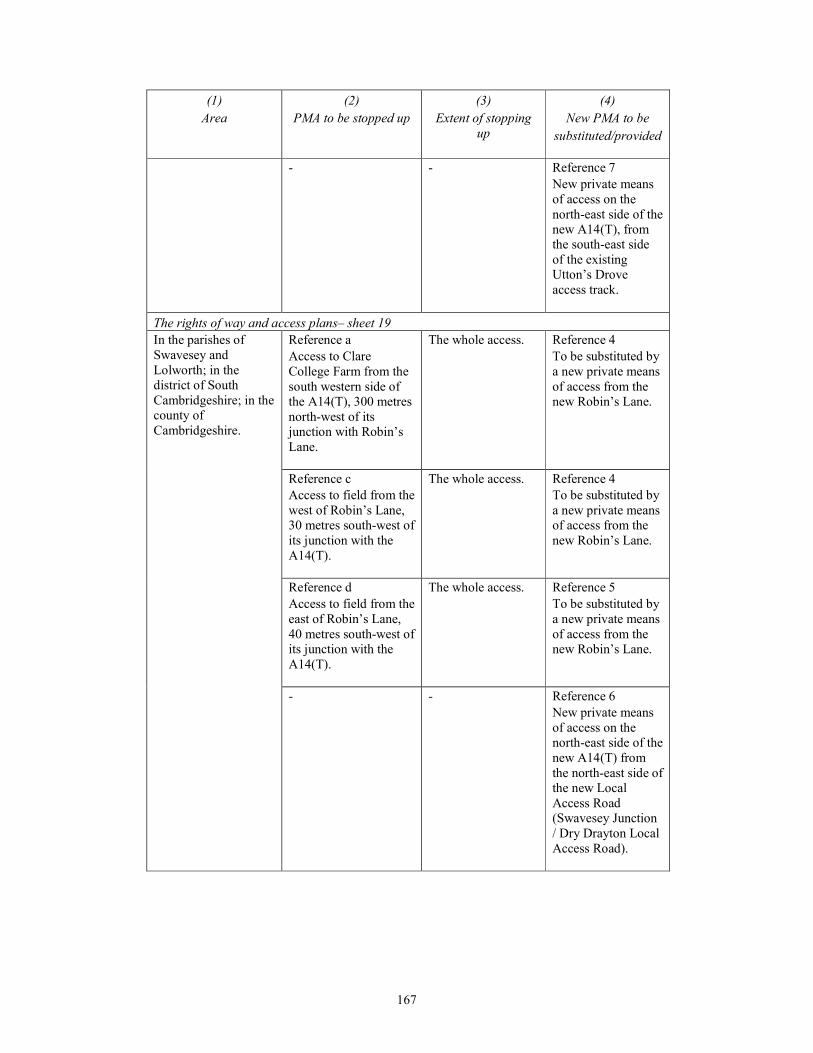
167
(1)
Area
(2)
PMA to be stopped up
(3)
Extent of stopping
up
(4)
New PMA to be
substituted/provided
- - Reference 7
New private means
of access on the
north-east side of the
new A14(T), from
the south-east side
of the existing
Utton’s Drove
access track.
The rights of way and access plans– sheet 19
In the parishes of
Swavesey and
Lolworth; in the
district of South
Cambridgeshire; in the
county of
Cambridgeshire.
Reference a
Access to Clare
College Farm from the
south western side of
the A14(T), 300 metres
north-west of its
junction with Robin’s
Lane.
The whole access. Reference 4
To be substituted by
a new private means
of access from the
new Robin’s Lane.
Reference c
Access to field from the
west of Robin’s Lane,
30 metres south-west of
its junction with the
A14(T).
The whole access. Reference 4
To be substituted by
a new private means
of access from the
new Robin’s Lane.
Reference d
Access to field from the
east of Robin’s Lane,
40 metres south-west of
its junction with the
A14(T).
The whole access. Reference 5
To be substituted by
a new private means
of access from the
new Robin’s Lane.
- - Reference 6
New private means
of access on the
north-east side of the
new A14(T) from
the north-east side of
the new Local
Access Road
(Swavesey Junction
/ Dry Drayton Local
Access Road).

168
(1)
Area
(2)
PMA to be stopped up
(3)
Extent of stopping
up
(4)
New PMA to be
substituted/provided
- - Reference 1
New private means
of access on the
north-east side of the
new A14(T) from
the south-east side
of the existing
private means of
access to The White
House and Hill
Farm.
- - Reference 2
New private means
of access on the
north-east side of the
new A14(T) from
the south-east side
of the existing
private means of
access to The White
House and Hill
Farm.
The rights of way and access plans– sheet 20
In the parishes of
Lolworth,
Longstanton, Bar Hill
and Oakington and
Westwick; in the
district of South
Cambridgeshire; in the
county of
Cambridgeshire.
Reference a
Access to field from the
west of the B1050
Hattons Road, 280
metres north-east of its
junction with the
A14(T).
The whole access. Reference 2
To be substituted by
a new private means
of access from the
new Local Access
Road (Swavesey
Junction / Dry
Drayton Local
Access Road)
(Reference reference
D - sheet 20).
Reference b
Access to Noon Folly
Farm from the west of
the B1050 Hattons
Road, 570 metres
north-east of its
junction with the
A14(T).
A length from its
junction with the
B1050 Hattons
Road, north-
westward for a
distance of 17
metres.
Reference 3
To be substituted by
a new private means
of access in the
same location as
stopped up access
Reference b, but
repositioned at the
highway boundary
of the new B1050
Hattons Road.
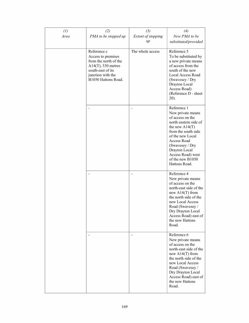
169
(1)
Area
(2)
PMA to be stopped up
(3)
Extent of stopping
up
(4)
New PMA to be
substituted/provided
Reference c
Access to premises
from the north of the
A14(T), 530 metres
south-east of its
junction with the
B1050 Hattons Road.
The whole access Reference 5
To be substituted by
a new private means
of access from the
south of the new
Local Access Road
(Swavesey / Dry
Drayton Local
Access Road)
(Reference D - sheet
20).
- - Reference 1
New private means
of access on the
north eastern side of
the new A14(T)
from the south side
of the new Local
Access Road
(Swavesey / Dry
Drayton Local
Access Road) west
of the new B1050
Hattons Road.
- - Reference 4
New private means
of access on the
north-east side of the
new A14(T) from
the north side of the
new Local Access
Road (Swavesey /
Dry Drayton Local
Access Road) east of
the new Hattons
Road.
- - Reference 6
New private means
of access on the
north-east side of the
new A14(T) from
the north side of the
new Local Access
Road (Swavesey /
Dry Drayton Local
Access Road) east of
the new Hattons
Road.
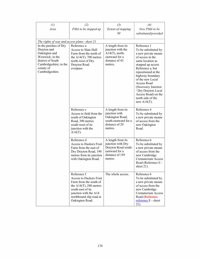
170
(1)
Area
(2)
PMA to be stopped up
(3)
Extent of stopping
up
(4)
New PMA to be
substituted/provided
The rights of way and access plans– sheet 21
In the parishes of Dry
Drayton and
Oakington and
Westwick; in the
district of South
Cambridgeshire; in the
county of
Cambridgeshire.
Reference a
Access to Slate Hall
Farm from the north of
the A14(T), 700 metres
north-west of Dry
Drayton Road
overpass.
A length from its
junction with the
A14(T), north-
eastward for a
distance of 43
metres.
Reference 1
To be substituted by
a new private means
of access in the
same location as
stopped up access
Reference a, but
repositioned at the
highway boundary
of the new Local
Access Road
(Swavesey Junction
/ Dry Drayton Local
Access Road) on the
north side of the
new A14(T).
Reference c
Access to field from the
south of Oakington
Road, 390 metres
south-west of its
junction with the
A14(T).
A length from its
junction with
Oakington Road,
south-eastward for a
distance of 20
metres.
Reference 4
To be substituted by
a new private means
of access from the
new Oakington
Road.
Reference d
Access to Hackers Fruit
Farm from the east of
Dry Drayton Road, 190
metres from its junction
with Oakington Road.
A length from its
junction with Dry
Drayton Road south-
eastward for a
distance of 195
metres.
Reference 6
To be substituted by
a new private means
of access from the
new Cambridge
Crematorium Access
Road (Reference E -
sheet 21).
Reference f
Access to Hackers Fruit
Farm from the south of
the A14(T), 280 metres
south-east of its
junction with the A14
northbound slip road at
Oakington Road.
The whole access. Reference 6
To be substituted by
a new private means
of access from the
new Cambridge
Crematorium Access
Road (Reference
reference E - sheet
21).

171
(1)
Area
(2)
PMA to be stopped up
(3)
Extent of stopping
up
(4)
New PMA to be
substituted/provided
Reference g
Access to premises
from the south of the
A14(T), 340 metres
south-east of its
junction with the A14
northbound slip road at
Oakington Road.
The whole access.
Reference 6
To be substituted by
a new private means
of access from the
new Cambridge
Crematorium Access
Road (Reference E -
sheet 21).
Reference h.
Access to Hackers Fruit
Farm from the south of
the A14(T), 360 metres
south-east of its
junction with the A14
northbound slip road at
Oakington Road.
The whole access. Reference 6
To be substituted by
a new private means
of access from the
new Cambridge
Crematorium Access
Road (Reference E -
sheet 21).
Reference i
Access to Cambridge
Crematorium from the
south of the A14(T),
605 metres south-east
of its junction with the
A14 northbound slip
road at Oakington
Road.
The whole access. Reference 7
To be substituted by
a new private means
of access from the
new Cambridge
Crematorium Access
Road (Reference E -
sheet 21).
- - Reference 2
New private means
of access on the
north-east side of the
new A14(T) from
the north-east side of
the new Local
Access Road
(Swavesey / Dry
Drayton Local
Access Road).
- - Reference 3
New private means
of access on the
north-east side of the
new A14(T) from
the south-west side
of the new Local
Access Road
(Swavesey / Dry
Drayton Local
Access Road).

172
(1)
Area
(2)
PMA to be stopped up
(3)
Extent of stopping
up
(4)
New PMA to be
substituted/provided
- - Reference 5
New private means
of access on the
south-west side of
the new A14(T)
from the north side
of the new
Oakington Road
roundabout junction.
- - Reference 8
New private means
of access on the
north-east side of the
new A14(T) from
the new Dry
Drayton Road / new
Local Access Road
(Swavesey Junction
/ Dry Drayton Local
Access Road) / new
Dry Drayton to
Girton Access Track
roundabout junction
to the A14 bridge
overpass at Footpath
99/4 (for
continuation of
Reference 8 see
sheets 22, 23 and
24).
- - Reference 9
New private means
of access to field on
the south side of the
new Cambridge
Crematorium Access
Road (Reference E –
sheet 21)
The rights of way and access plans– sheet 22
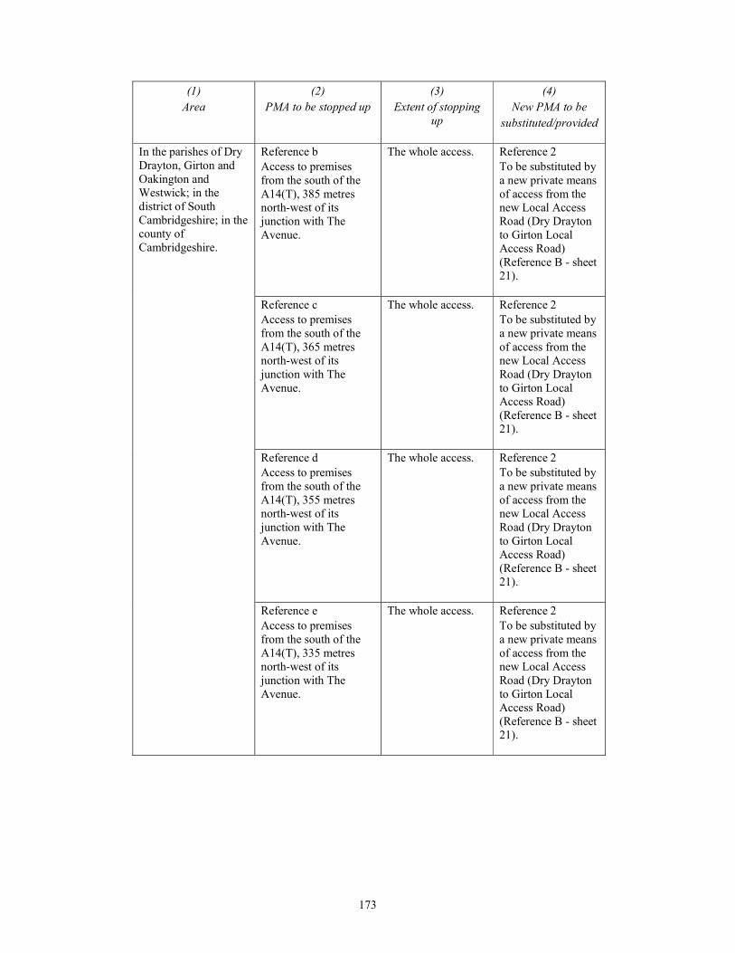
173
(1)
Area
(2)
PMA to be stopped up
(3)
Extent of stopping
up
(4)
New PMA to be
substituted/provided
In the parishes of Dry
Drayton, Girton and
Oakington and
Westwick; in the
district of South
Cambridgeshire; in the
county of
Cambridgeshire.
Reference b
Access to premises
from the south of the
A14(T), 385 metres
north-west of its
junction with The
Avenue.
The whole access. Reference 2
To be substituted by
a new private means
of access from the
new Local Access
Road (Dry Drayton
to Girton Local
Access Road)
(Reference B - sheet
21).
Reference c
Access to premises
from the south of the
A14(T), 365 metres
north-west of its
junction with The
Avenue.
The whole access. Reference 2
To be substituted by
a new private means
of access from the
new Local Access
Road (Dry Drayton
to Girton Local
Access Road)
(Reference B - sheet
21).
Reference d
Access to premises
from the south of the
A14(T), 355 metres
north-west of its
junction with The
Avenue.
The whole access. Reference 2
To be substituted by
a new private means
of access from the
new Local Access
Road (Dry Drayton
to Girton Local
Access Road)
(Reference B - sheet
21).
Reference e
Access to premises
from the south of the
A14(T), 335 metres
north-west of its
junction with The
Avenue.
The whole access. Reference 2
To be substituted by
a new private means
of access from the
new Local Access
Road (Dry Drayton
to Girton Local
Access Road)
(Reference B - sheet
21).
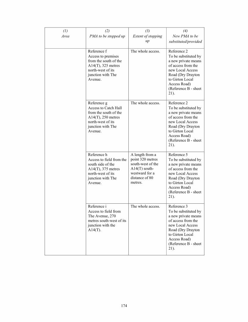
174
(1)
Area
(2)
PMA to be stopped up
(3)
Extent of stopping
up
(4)
New PMA to be
substituted/provided
Reference f
Access to premises
from the south of the
A14(T), 325 metres
north-west of its
junction with The
Avenue.
The whole access. Reference 2
To be substituted by
a new private means
of access from the
new Local Access
Road (Dry Drayton
to Girton Local
Access Road)
(Reference B - sheet
21).
Reference g
Access to Catch Hall
from the south of the
A14(T), 250 metres
north-west of its
junction with The
Avenue.
The whole access. Reference 2
To be substituted by
a new private means
of access from the
new Local Access
Road (Dry Drayton
to Girton Local
Access Road)
(Reference B - sheet
21).
Reference h
Access to field from the
south side of the
A14(T), 375 metres
north-west of its
junction with The
Avenue.
A length from a
point 320 metres
south-west of the
A14(T) south-
westward for a
distance of 80
metres.
Reference 5
To be substituted by
a new private means
of access from the
new Local Access
Road (Dry Drayton
to Girton Local
Access Road)
(Reference B - sheet
21).
Reference i
Access to field from
The Avenue, 270
metres south-west of its
junction with the
A14(T).
The whole access. Reference 3
To be substituted by
a new private means
of access from the
new Local Access
Road (Dry Drayton
to Girton Local
Access Road)
(Reference B - sheet
21).
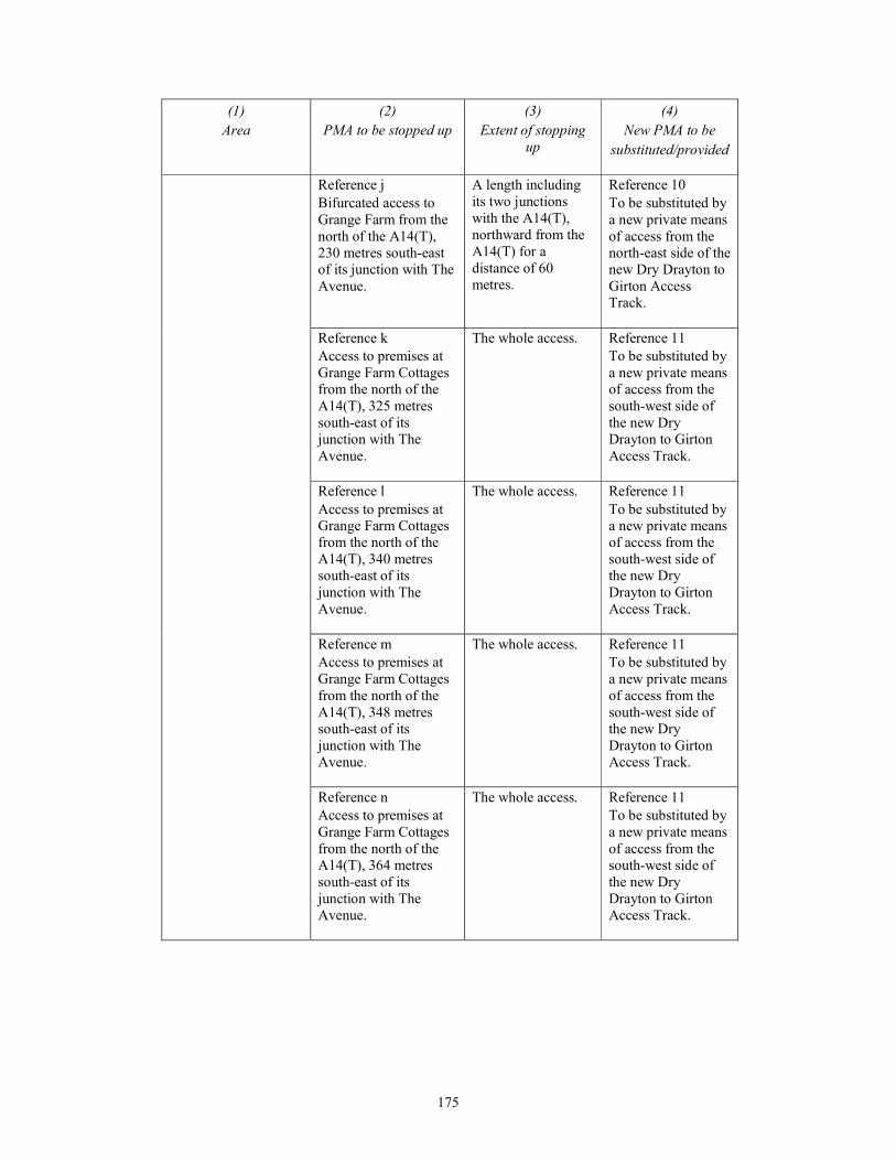
175
(1)
Area
(2)
PMA to be stopped up
(3)
Extent of stopping
up
(4)
New PMA to be
substituted/provided
Reference j
Bifurcated access to
Grange Farm from the
north of the A14(T),
230 metres south-east
of its junction with The
Avenue.
A length including
its two junctions
with the A14(T),
northward from the
A14(T) for a
distance of 60
metres.
Reference 10
To be substituted by
a new private means
of access from the
north-east side of the
new Dry Drayton to
Girton Access
Track.
Reference k
Access to premises at
Grange Farm Cottages
from the north of the
A14(T), 325 metres
south-east of its
junction with The
Avenue.
The whole access. Reference 11
To be substituted by
a new private means
of access from the
south-west side of
the new Dry
Drayton to Girton
Access Track.
Reference l
Access to premises at
Grange Farm Cottages
from the north of the
A14(T), 340 metres
south-east of its
junction with The
Avenue.
The whole access. Reference 11
To be substituted by
a new private means
of access from the
south-west side of
the new Dry
Drayton to Girton
Access Track.
Reference m
Access to premises at
Grange Farm Cottages
from the north of the
A14(T), 348 metres
south-east of its
junction with The
Avenue.
The whole access. Reference 11
To be substituted by
a new private means
of access from the
south-west side of
the new Dry
Drayton to Girton
Access Track.
Reference n
Access to premises at
Grange Farm Cottages
from the north of the
A14(T), 364 metres
south-east of its
junction with The
Avenue.
The whole access. Reference 11
To be substituted by
a new private means
of access from the
south-west side of
the new Dry
Drayton to Girton
Access Track.
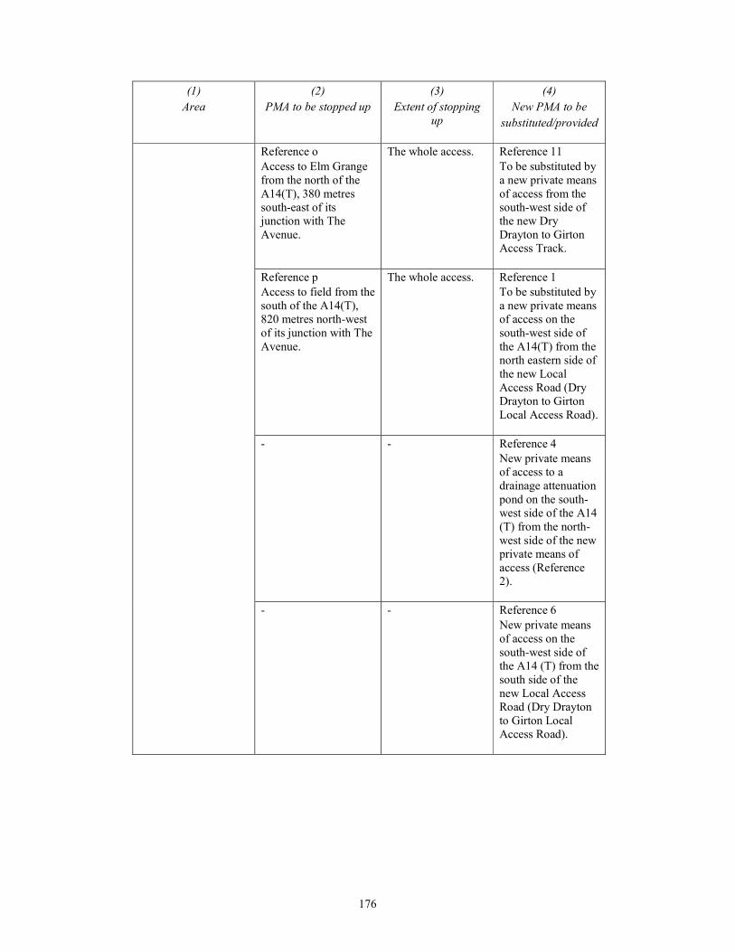
176
(1)
Area
(2)
PMA to be stopped up
(3)
Extent of stopping
up
(4)
New PMA to be
substituted/provided
Reference o
Access to Elm Grange
from the north of the
A14(T), 380 metres
south-east of its
junction with The
Avenue.
The whole access. Reference 11
To be substituted by
a new private means
of access from the
south-west side of
the new Dry
Drayton to Girton
Access Track.
Reference p
Access to field from the
south of the A14(T),
820 metres north-west
of its junction with The
Avenue.
The whole access. Reference 1
To be substituted by
a new private means
of access on the
south-west side of
the A14(T) from the
north eastern side of
the new Local
Access Road (Dry
Drayton to Girton
Local Access Road).
- - Reference 4
New private means
of access to a
drainage attenuation
pond on the south-
west side of the A14
(T) from the north-
west side of the new
private means of
access (Reference
2).
- - Reference 6
New private means
of access on the
south-west side of
the A14 (T) from the
south side of the
new Local Access
Road (Dry Drayton
to Girton Local
Access Road).
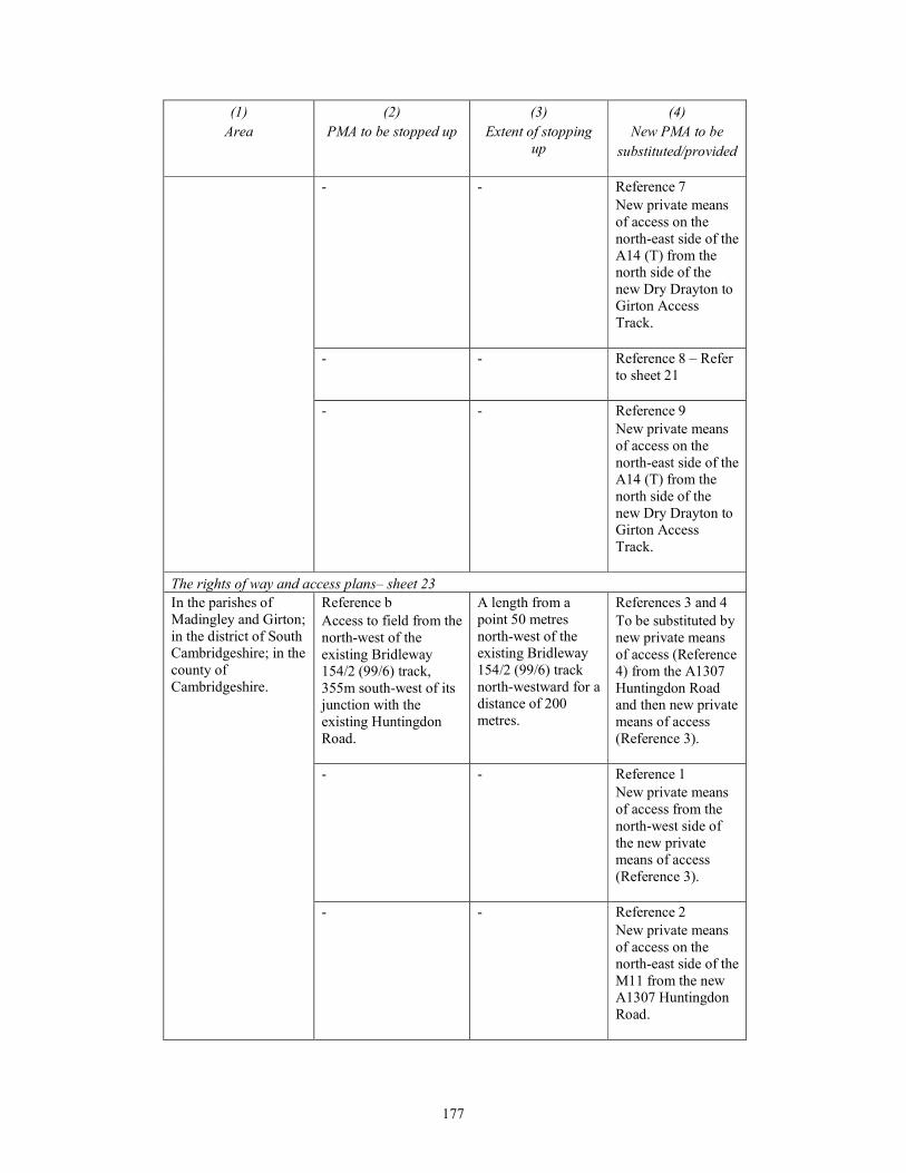
177
(1)
Area
(2)
PMA to be stopped up
(3)
Extent of stopping
up
(4)
New PMA to be
substituted/provided
- - Reference 7
New private means
of access on the
north-east side of the
A14 (T) from the
north side of the
new Dry Drayton to
Girton Access
Track.
- - Reference 8 – Refer
to sheet 21
- - Reference 9
New private means
of access on the
north-east side of the
A14 (T) from the
north side of the
new Dry Drayton to
Girton Access
Track.
The rights of way and access plans– sheet 23
In the parishes of
Madingley and Girton;
in the district of South
Cambridgeshire; in the
county of
Cambridgeshire.
Reference b
Access to field from the
north-west of the
existing Bridleway
154/2 (99/6) track,
355m south-west of its
junction with the
existing Huntingdon
Road.
A length from a
point 50 metres
north-west of the
existing Bridleway
154/2 (99/6) track
north-westward for a
distance of 200
metres.
References 3 and 4
To be substituted by
new private means
of access (Reference
4) from the A1307
Huntingdon Road
and then new private
means of access
(Reference 3).
- - Reference 1
New private means
of access from the
north-west side of
the new private
means of access
(Reference 3).
- - Reference 2
New private means
of access on the
north-east side of the
M11 from the new
A1307 Huntingdon
Road.
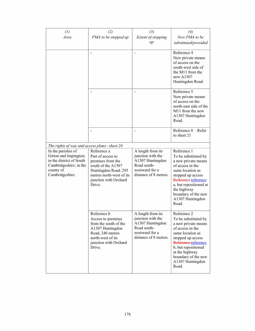
178
(1)
Area
(2)
PMA to be stopped up
(3)
Extent of stopping
up
(4)
New PMA to be
substituted/provided
- - Reference 4
New private means
of access on the
south-west side of
the M11 from the
new A1307
Huntingdon Road.
- - Reference 5
New private means
of access on the
north-east side of the
M11 from the new
A1307 Huntingdon
Road.
- - Reference 8 – Refer
to sheet 21
The rights of way and access plans– sheet 24
In the parishes of
Girton and Impington;
in the district of South
Cambridgeshire; in the
county of
Cambridgeshire.
Reference a
Part of access to
premises from the
south of the A1307
Huntingdon Road, 295
metres north-west of its
junction with Orchard
Drive.
A length from its
junction with the
A1307 Huntingdon
Road south-
westward for a
distance of 8 metres.
Reference 1
To be substituted by
a new private means
of access in the
same location as
stopped up access
Reference reference
a, but repositioned at
the highway
boundary of the new
A1307 Huntingdon
Road.
Reference b
Access to premises
from the south of the
A1307 Huntingdon
Road, 240 metres
north-west of its
junction with Orchard
Drive.
A length from its
junction with the
A1307 Huntingdon
Road south-
westward for a
distance of 8 metres.
Reference 2
To be substituted by
a new private means
of access in the
same location as
stopped up access
Reference reference
b, but repositioned
at the highway
boundary of the new
A1307 Huntingdon
Road.
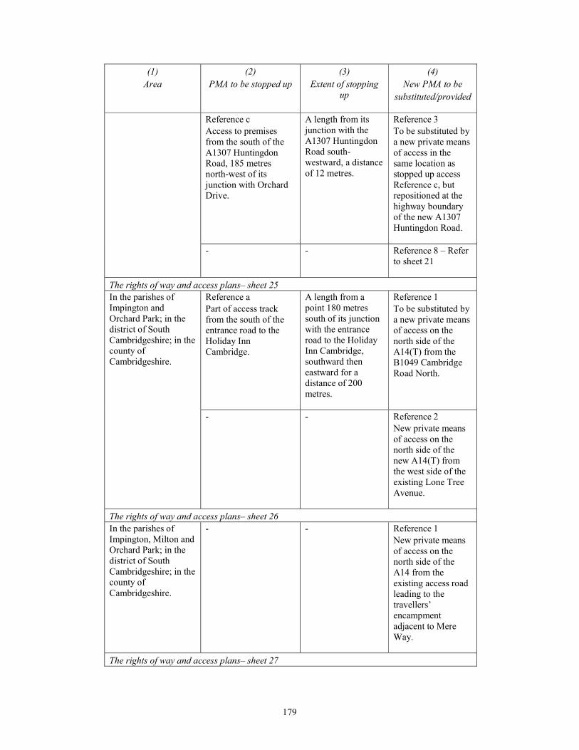
179
(1)
Area
(2)
PMA to be stopped up
(3)
Extent of stopping
up
(4)
New PMA to be
substituted/provided
Reference c
Access to premises
from the south of the
A1307 Huntingdon
Road, 185 metres
north-west of its
junction with Orchard
Drive.
A length from its
junction with the
A1307 Huntingdon
Road south-
westward, a distance
of 12 metres.
Reference 3
To be substituted by
a new private means
of access in the
same location as
stopped up access
Reference c, but
repositioned at the
highway boundary
of the new A1307
Huntingdon Road.
- - Reference 8 – Refer
to sheet 21
The rights of way and access plans– sheet 25
In the parishes of
Impington and
Orchard Park; in the
district of South
Cambridgeshire; in the
county of
Cambridgeshire.
Reference a
Part of access track
from the south of the
entrance road to the
Holiday Inn
Cambridge.
A length from a
point 180 metres
south of its junction
with the entrance
road to the Holiday
Inn Cambridge,
southward then
eastward for a
distance of 200
metres.
Reference 1
To be substituted by
a new private means
of access on the
north side of the
A14(T) from the
B1049 Cambridge
Road North.
- - Reference 2
New private means
of access on the
north side of the
new A14(T) from
the west side of the
existing Lone Tree
Avenue.
The rights of way and access plans– sheet 26
In the parishes of
Impington, Milton and
Orchard Park; in the
district of South
Cambridgeshire; in the
county of
Cambridgeshire.
- - Reference 1
New private means
of access on the
north side of the
A14 from the
existing access road
leading to the
travellers’
encampment
adjacent to Mere
Way.
The rights of way and access plans– sheet 27
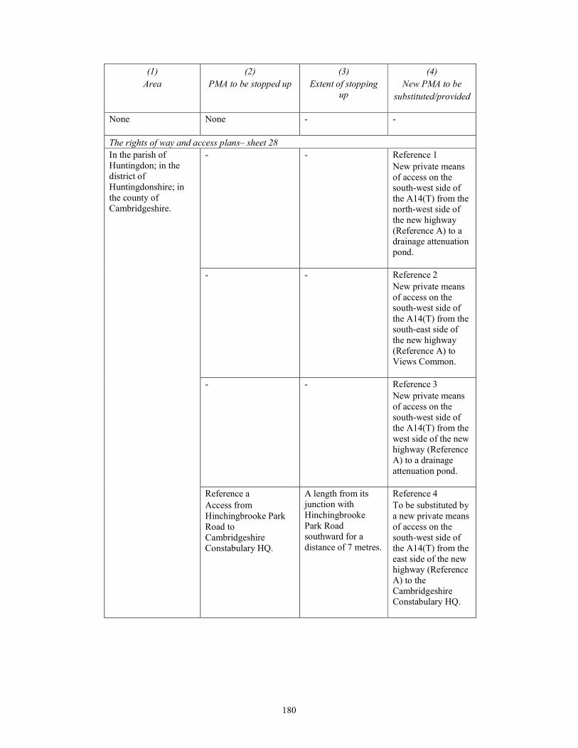
180
(1)
Area
(2)
PMA to be stopped up
(3)
Extent of stopping
up
(4)
New PMA to be
substituted/provided
None
None - -
The rights of way and access plans– sheet 28
In the parish of
Huntingdon; in the
district of
Huntingdonshire; in
the county of
Cambridgeshire.
- - Reference 1
New private means
of access on the
south-west side of
the A14(T) from the
north-west side of
the new highway
(Reference A) to a
drainage attenuation
pond.
- - Reference 2
New private means
of access on the
south-west side of
the A14(T) from the
south-east side of
the new highway
(Reference A) to
Views Common.
- - Reference 3
New private means
of access on the
south-west side of
the A14(T) from the
west side of the new
highway (Reference
A) to a drainage
attenuation pond.
Reference a
Access from
Hinchingbrooke Park
Road to
Cambridgeshire
Constabulary HQ.
A length from its
junction with
Hinchingbrooke
Park Road
southward for a
distance of 7 metres.
Reference 4
To be substituted by
a new private means
of access on the
south-west side of
the A14(T) from the
east side of the new
highway (Reference
A) to the
Cambridgeshire
Constabulary HQ.
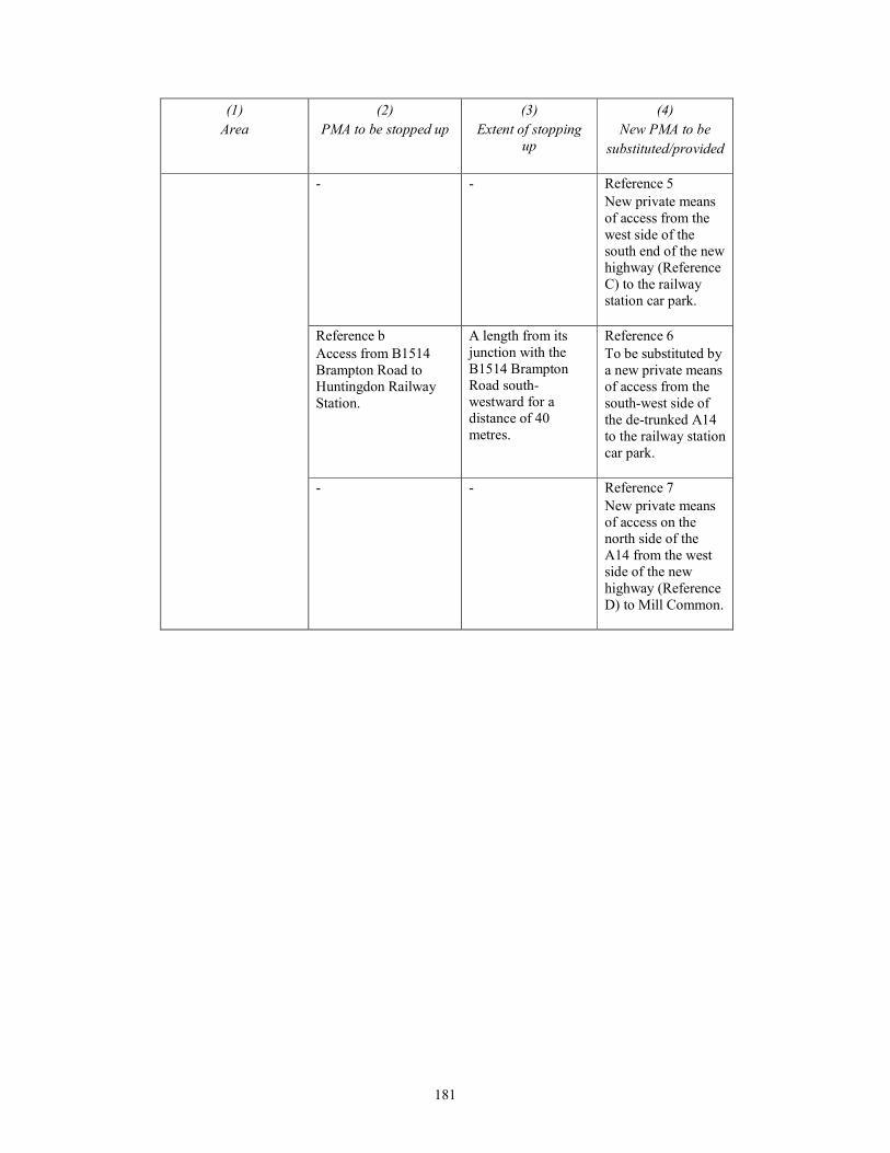
181
(1)
Area
(2)
PMA to be stopped up
(3)
Extent of stopping
up
(4)
New PMA to be
substituted/provided
- - Reference 5
New private means
of access from the
west side of the
south end of the new
highway (Reference
C) to the railway
station car park.
Reference b
Access from B1514
Brampton Road to
Huntingdon Railway
Station.
A length from its
junction with the
B1514 Brampton
Road south-
westward for a
distance of 40
metres.
Reference 6
To be substituted by
a new private means
of access from the
south-west side of
the de-trunked A14
to the railway station
car park.
- - Reference 7
New private means
of access on the
north side of the
A14 from the west
side of the new
highway (Reference
D) to Mill Common.

182
PART 4
PRIVATE MEANS OF ACCESS TO BE STOPPED UP FOR WHICH NO
SUBSTITUTE IS TO BE PROVIDED
(1)
Area
(2)
PMA to be stopped up
(3)
Extent of stopping up
The rights of way and access plans– sheet 1
In the parishes of
Alconbury and The
Stukeleys; in the
district of
Huntingdonshire; in
the county of
Cambridgeshire.
Reference a
Access to field from the west of the
A1(T), 640 metres south-east of its
junction with the B1043.
The whole access.
Reference b
Disused access to Huntingdon
Research Centre from the west of the
A1(T), 765 metres south-east of its
junction with the B1043.
The whole access.
The rights of way and access plans– sheet 2
None
None -
The rights of way and access plans– sheet 3
None
None -
The rights of way and access plans– sheet 4
None
None -
The rights of way and access plans– sheet 5
None
None -
The rights of way and access plans– sheet 6
None
None -
The rights of way and access plans– sheet 7
None
None -
The rights of way and access plans– sheet 8
None
None -
The rights of way and access plans– sheet 9
None
None -
The rights of way and access plans– sheet 10
None
None -
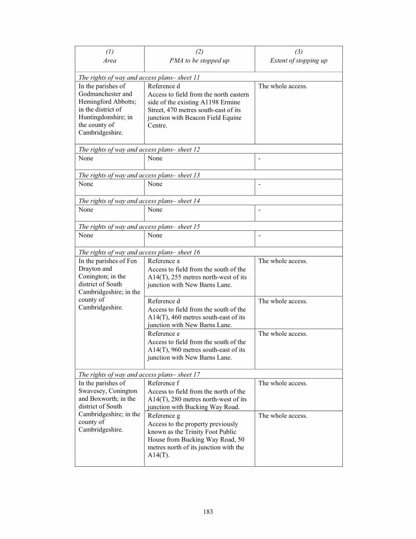
183
(1)
Area
(2)
PMA to be stopped up
(3)
Extent of stopping up
The rights of way and access plans– sheet 11
In the parishes of
Godmanchester and
Hemingford Abbotts;
in the district of
Huntingdonshire; in
the county of
Cambridgeshire.
Reference d
Access to field from the north eastern
side of the existing A1198 Ermine
Street, 470 metres south-east of its
junction with Beacon Field Equine
Centre.
The whole access.
The rights of way and access plans– sheet 12
None
None -
The rights of way and access plans– sheet 13
None
None -
The rights of way and access plans– sheet 14
None
None -
The rights of way and access plans– sheet 15
None
None -
The rights of way and access plans– sheet 16
In the parishes of Fen
Drayton and
Conington; in the
district of South
Cambridgeshire; in the
county of
Cambridgeshire.
Reference a
Access to field from the south of the
A14(T), 255 metres north-west of its
junction with New Barns Lane.
The whole access.
Reference d
Access to field from the south of the
A14(T), 460 metres south-east of its
junction with New Barns Lane.
The whole access.
Reference e
Access to field from the south of the
A14(T), 960 metres south-east of its
junction with New Barns Lane.
The whole access.
The rights of way and access plans– sheet 17
In the parishes of
Swavesey, Conington
and Boxworth; in the
district of South
Cambridgeshire; in the
county of
Cambridgeshire.
Reference f
Access to field from the north of the
A14(T), 280 metres north-west of its
junction with Bucking Way Road.
The whole access.
Reference g
Access to the property previously
known as the Trinity Foot Public
House from Bucking Way Road, 50
metres north of its junction with the
A14(T).
The whole access.
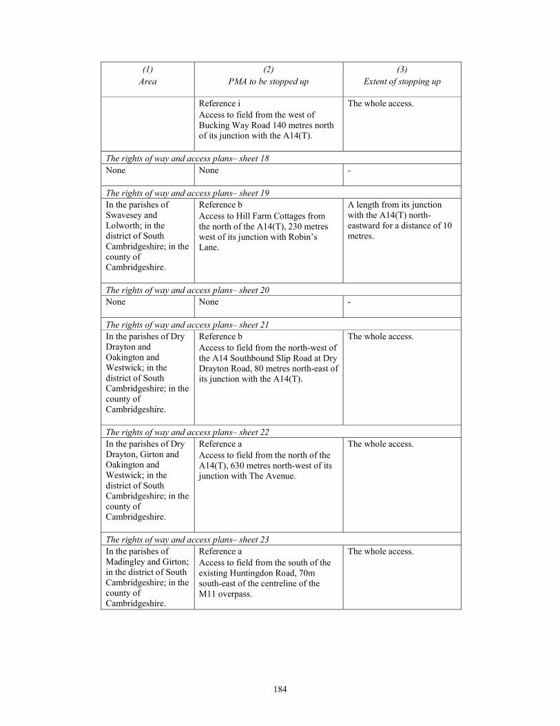
184
(1)
Area
(2)
PMA to be stopped up
(3)
Extent of stopping up
Reference i
Access to field from the west of
Bucking Way Road 140 metres north
of its junction with the A14(T).
The whole access.
The rights of way and access plans– sheet 18
None
None -
The rights of way and access plans– sheet 19
In the parishes of
Swavesey and
Lolworth; in the
district of South
Cambridgeshire; in the
county of
Cambridgeshire.
Reference b
Access to Hill Farm Cottages from
the north of the A14(T), 230 metres
west of its junction with Robin’s
Lane.
A length from its junction
with the A14(T) north-
eastward for a distance of 10
metres.
The rights of way and access plans– sheet 20
None
None -
The rights of way and access plans– sheet 21
In the parishes of Dry
Drayton and
Oakington and
Westwick; in the
district of South
Cambridgeshire; in the
county of
Cambridgeshire.
Reference b
Access to field from the north-west of
the A14 Southbound Slip Road at Dry
Drayton Road, 80 metres north-east of
its junction with the A14(T).
The whole access.
The rights of way and access plans– sheet 22
In the parishes of Dry
Drayton, Girton and
Oakington and
Westwick; in the
district of South
Cambridgeshire; in the
county of
Cambridgeshire.
Reference a
Access to field from the north of the
A14(T), 630 metres north-west of its
junction with The Avenue.
The whole access.
The rights of way and access plans– sheet 23
In the parishes of
Madingley and Girton;
in the district of South
Cambridgeshire; in the
county of
Cambridgeshire.
Reference a
Access to field from the south of the
existing Huntingdon Road, 70m
south-east of the centreline of the
M11 overpass.
The whole access.

185
(1)
Area
(2)
PMA to be stopped up
(3)
Extent of stopping up
Reference c
Access to field from the south eastern
side of the existing Bridleway 154/2
(99/6) track, 200m north-east of the
Bridleway 154/2 overpass.
A length from a point 145
metres north-east of its south
western junction with
Bridleway154/2 (99/6) north
eastward for a distance of 186
metres.
The rights of way and access plans– sheet 24
None
None -
The rights of way and access plans– sheet 25
None
None -
The rights of way and access plans– sheet 26
None
None -
The rights of way and access plans– sheet 27
None
None -
The rights of way and access plans– sheet 28
None
None -

186
SCHEDULE 5 Article 23
LAND IN WHICH ONLY NEW RIGHTS ETC., MAY BE ACQUIRED
(1)
Plot Reference Number
shown on land plans
(2)
Purpose for which rights over land may be acquired
The land plans – sheet 1
- None
The land plans – sheet 2
2/1aa, 2/1j, 2/1s, 2/1w and
2/5b
New right to construct and maintain a new track to drainage
attenuation ponds and areas of flood compensation and to
access with or without vehicles plant and machinery for the
benefit of the undertaker.
New right of access to land (plot 3/14a) with or without
vehicles plant and machinery for the benefit of Farmland
Reserve UK Limited, Manor Farm, Church End,
Woodwalton, Huntingdon, PE28 5YU (and their successors
in title).
New right of access to land (plots 2/11d, 3/6c and 3/9a) with
or without vehicles plant and machinery for the benefit of
Angus George Lammie of Church Farm, Tempsford, Sandy,
SG19 2AN (and his successors in title).
2/1k and 2/4c New right to construct and maintain a new track to drainage
attenuation ponds and areas of flood compensation and to
access with or without vehicles plant and machinery for the
benefit of the undertaker.
New right of access to land (plot 3/14a) with or without
vehicles plant and machinery for the benefit of Farmland
Reserve UK Limited, Manor Farm, Church End,
Woodwalton, Huntingdon, PE28 5YU (and their successors
in title).
2/11b New right to construct and maintain a new track to drainage
attenuation ponds and areas of flood compensation and to
access with or without vehicles plant and machinery for the
benefit of the undertaker.
New right of access to land (plot 3/14a) with or without
vehicles plant and machinery for the benefit of Farmland
Reserve UK Limited, Manor Farm, Church End,
Woodwalton, Huntingdon, PE28 5YU (and their successors
in title).

187
(1)
Plot Reference Number
shown on land plans
(2)
Purpose for which rights over land may be acquired
The land plans – sheet 3
3/1d, 3/6b, 3/7b, and 3/9b New right to construct and maintain a new track to drainage
attenuation ponds and areas of flood compensation and to
access with or without vehicles plant and machinery for the
benefit of the undertaker.
New right of access to land (plot 3/14a) with or without
vehicles plant and machinery for the benefit of Farmland
Reserve UK Limited, Manor Farm, Church End,
Woodwalton, Huntingdon, PE28 5YU (and their successors
in title).
3/14b and 3/15b New right to construct and maintain a new track to drainage
attenuation ponds and areas of flood compensation and to
access with or without vehicles plant and machinery for the
benefit of the undertaker.
The land plans – sheet 4
4/6a New right to construct, use, protect, inspect and maintain a
water pipeline and equipment for the benefit of Anglian
Water Services Ltd.
The land plans – sheet 5
5/4b, 5/5b and 5/22b New right to construct and maintain a new track to drainage
attenuation ponds and areas of flood compensation and to
access with or without vehicles plant and machinery for the
benefit of the undertaker.
5/7 New right of access to environmental mitigation land (plot
5/2c) with or without vehicles, plant and machinery for the
benefit of the undertaker.
5/12a New right to construct, use, protect, inspect and maintain a
water pipeline and equipment for the benefit of Anglian
Water Services Ltd.
New right to install, inspect and maintain a new electricity
power line and equipment for the benefit of UK Power
Networks Holdings Ltd.
The land plans – sheet 6
- None
The land plans – sheet 7
- None
The land plans – sheet 8
8/7d New right to construct, use, protect, inspect and maintain a
water pipeline and equipment for the benefit of Anglian
Water Services Ltd.

188
(1)
Plot Reference Number
shown on land plans
(2)
Purpose for which rights over land may be acquired
8/17b, 8/19b, 8/22b, 8/25a,
8/21k and 8/21n
New right to construct and maintain a new track to access the
new River Great Ouse viaduct, drainage attenuation pond
and outfalls, and environmental mitigation land (plot8/21l)
with or without vehicles, plant and machinery for the benefit
of the undertaker.
The land plans – sheet 9
9/2c, 9/2g and 9/4b New right to construct and maintain a new track to access the
new River Great Ouse viaduct and drainage outfalls with or
without vehicles plant and machinery for the benefit of the
undertaker.
9/10 New right to construct, use and maintain a drainage outfall
for the benefit of the undertaker.
9/16b New right to construct, use and maintain a bridge over the
East Coast Mainline Railway for the benefit of the
undertaker.
9/6, 9/7, 9/8, 9/9, 9/11,
9/11a, 9/11b, 9/12c and 9/14
New right to construct and maintain a new track to access the
River Great Ouse viaduct and drainage attenuation pond with
or without vehicles plant and machinery for the benefit of the
undertaker.
The land plans – sheet 10
10/4e New right to construct a new access track and to access with
or without vehicles plant and machinery for the benefit of
Church Commissioners For England, 27 Great Smith Street,
London, SW1P 3AZ (and their successors in title) in respect
of Wybosten Farm.
10/7b New right to construct a new track and to access with or
without vehicles plant and machinery for the benefit of
Anthony William Carr and David Gordon Carr of Offord Hill
Farm, Offord Road, Godmanchester, Huntingdon, PE29 2LD
(and their successors in title) in respect of Offord Hill Farm.
The land plans – sheet 11
- None
The land plans – sheet 12
12/11a New right to construct and maintain a new track to drainage
attenuation ponds and areas of flood compensation and to
access with or without vehicles plant and machinery for the
benefit of the undertaker.
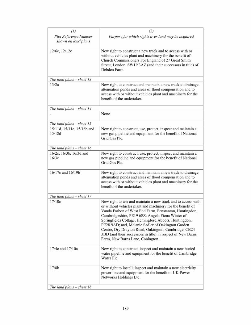
189
(1)
Plot Reference Number
shown on land plans
(2)
Purpose for which rights over land may be acquired
12/6e, 12/12c New right to construct a new track and to access with or
without vehicles plant and machinery for the benefit of
Church Commissioners For England of 27 Great Smith
Street, London, SW1P 3AZ (and their successors in title) of
Debden Farm.
The land plans – sheet 13
13/2a New right to construct and maintain a new track to drainage
attenuation ponds and areas of flood compensation and to
access with or without vehicles plant and machinery for the
benefit of the undertaker.
The land plans – sheet 14
- None
The land plans – sheet 15
15/11d, 15/11e, 15/18b and
15/18d
New right to construct, use, protect, inspect and maintain a
new gas pipeline and equipment for the benefit of National
Grid Gas Plc.
The land plans – sheet 16
16/2c, 16/3b, 16/3d and
16/3e
New right to construct, use, protect, inspect and maintain a
new gas pipeline and equipment for the benefit of National
Grid Gas Plc.
16/17c and 16/19b New right to construct and maintain a new track to drainage
attenuation ponds and areas of flood compensation and to
access with or without vehicles plant and machinery for the
benefit of the undertaker.
The land plans – sheet 17
17/10c New right to use and maintain a new track and to access with
or without vehicles plant and machinery for the benefit of
Vanda Farbon of West End Farm, Fenstanton, Huntingdon,
Cambridgeshire, PE19 6SZ; Angela Fiona Winter of
Springfields Cottage, Hemingford Abbots, Huntingdon,
PE28 9AD; and, Melanie Sadler of Oakington Garden
Centre, Dry Drayton Road, Oakington, Cambridge, CB24
3BD (and their successors in title) in respect of New Barns
Farm, New Barns Lane, Conington.
17/4c and 17/10a New right to construct, inspect and maintain a new buried
water pipeline and equipment for the benefit of Cambridge
Water Plc.
17/8b New right to install, inspect and maintain a new electricity
power line and equipment for the benefit of UK Power
Networks Holdings Ltd.
The land plans – sheet 18
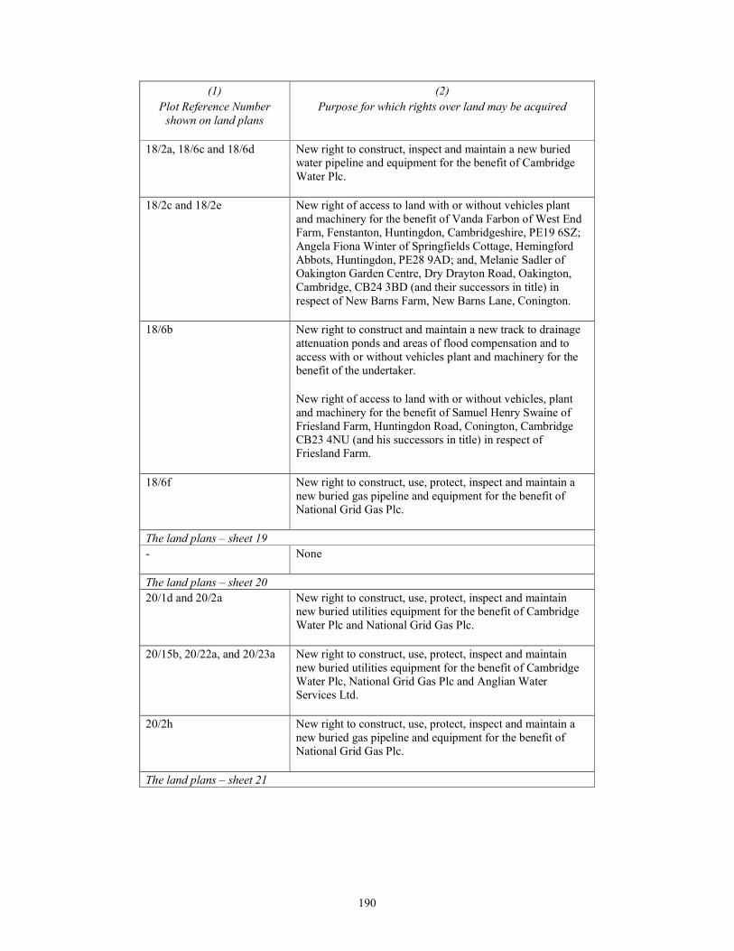
190
(1)
Plot Reference Number
shown on land plans
(2)
Purpose for which rights over land may be acquired
18/2a, 18/6c and 18/6d New right to construct, inspect and maintain a new buried
water pipeline and equipment for the benefit of Cambridge
Water Plc.
18/2c and 18/2e New right of access to land with or without vehicles plant
and machinery for the benefit of Vanda Farbon of West End
Farm, Fenstanton, Huntingdon, Cambridgeshire, PE19 6SZ;
Angela Fiona Winter of Springfields Cottage, Hemingford
Abbots, Huntingdon, PE28 9AD; and, Melanie Sadler of
Oakington Garden Centre, Dry Drayton Road, Oakington,
Cambridge, CB24 3BD (and their successors in title) in
respect of New Barns Farm, New Barns Lane, Conington.
18/6b New right to construct and maintain a new track to drainage
attenuation ponds and areas of flood compensation and to
access with or without vehicles plant and machinery for the
benefit of the undertaker.
New right of access to land with or without vehicles, plant
and machinery for the benefit of Samuel Henry Swaine of
Friesland Farm, Huntingdon Road, Conington, Cambridge
CB23 4NU (and his successors in title) in respect of
Friesland Farm.
18/6f New right to construct, use, protect, inspect and maintain a
new buried gas pipeline and equipment for the benefit of
National Grid Gas Plc.
The land plans – sheet 19
- None
The land plans – sheet 20
20/1d and 20/2a New right to construct, use, protect, inspect and maintain
new buried utilities equipment for the benefit of Cambridge
Water Plc and National Grid Gas Plc.
20/15b, 20/22a, and 20/23a New right to construct, use, protect, inspect and maintain
new buried utilities equipment for the benefit of Cambridge
Water Plc, National Grid Gas Plc and Anglian Water
Services Ltd.
20/2h New right to construct, use, protect, inspect and maintain a
new buried gas pipeline and equipment for the benefit of
National Grid Gas Plc.
The land plans – sheet 21
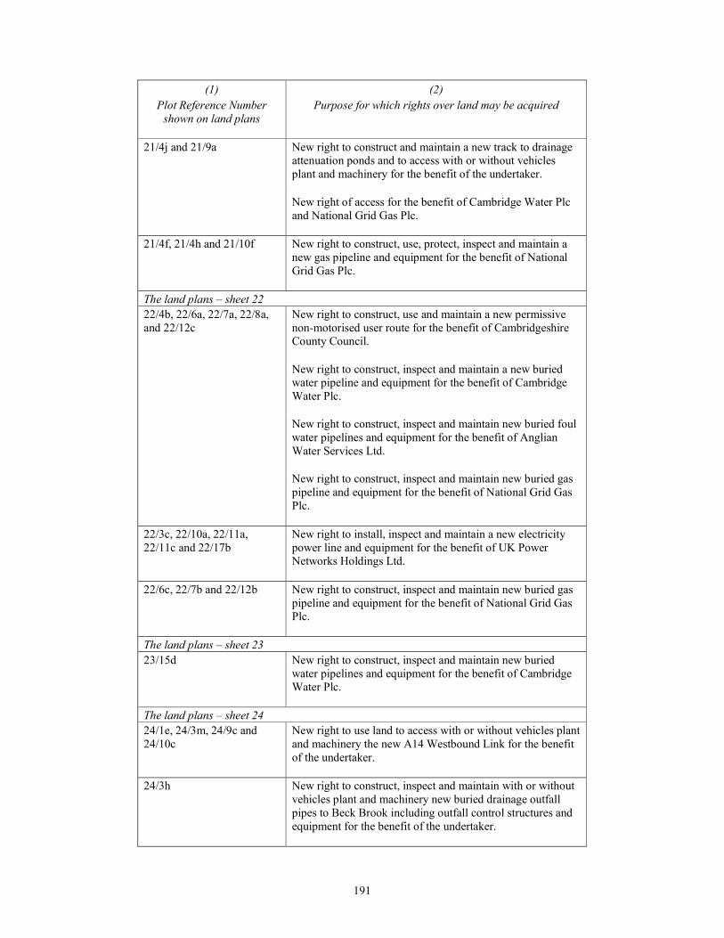
191
(1)
Plot Reference Number
shown on land plans
(2)
Purpose for which rights over land may be acquired
21/4j and 21/9a New right to construct and maintain a new track to drainage
attenuation ponds and to access with or without vehicles
plant and machinery for the benefit of the undertaker.
New right of access for the benefit of Cambridge Water Plc
and National Grid Gas Plc.
21/4f, 21/4h and 21/10f New right to construct, use, protect, inspect and maintain a
new gas pipeline and equipment for the benefit of National
Grid Gas Plc.
The land plans – sheet 22
22/4b, 22/6a, 22/7a, 22/8a,
and 22/12c
New right to construct, use and maintain a new permissive
non-motorised user route for the benefit of Cambridgeshire
County Council.
New right to construct, inspect and maintain a new buried
water pipeline and equipment for the benefit of Cambridge
Water Plc.
New right to construct, inspect and maintain new buried foul
water pipelines and equipment for the benefit of Anglian
Water Services Ltd.
New right to construct, inspect and maintain new buried gas
pipeline and equipment for the benefit of National Grid Gas
Plc.
22/3c, 22/10a, 22/11a,
22/11c and 22/17b
New right to install, inspect and maintain a new electricity
power line and equipment for the benefit of UK Power
Networks Holdings Ltd.
22/6c, 22/7b and 22/12b New right to construct, inspect and maintain new buried gas
pipeline and equipment for the benefit of National Grid Gas
Plc.
The land plans – sheet 23
23/15d New right to construct, inspect and maintain new buried
water pipelines and equipment for the benefit of Cambridge
Water Plc.
The land plans – sheet 24
24/1e, 24/3m, 24/9c and
24/10c
New right to use land to access with or without vehicles plant
and machinery the new A14 Westbound Link for the benefit
of the undertaker.
24/3h New right to construct, inspect and maintain with or without
vehicles plant and machinery new buried drainage outfall
pipes to Beck Brook including outfall control structures and
equipment for the benefit of the undertaker.
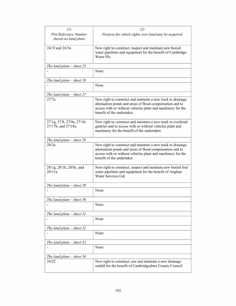
192
(1)
Plot Reference Number
shown on land plans
(2)
Purpose for which rights over land may be acquired
24/3f and 24/3n New right to construct, inspect and maintain new buried
water pipelines and equipment for the benefit of Cambridge
Water Plc.
The land plans – sheet 25
- None
The land plans – sheet 26
- None
The land plans – sheet 27
27/7a New right to construct and maintain a new track to drainage
attenuation ponds and areas of flood compensation and to
access with or without vehicles plant and machinery for the
benefit of the undertaker.
27/1g, 27/8, 27/9a, 27/10,
27/17b, and 27/18a
New right to construct and maintain a new track to overhead
gantries and to access with or without vehicles plant and
machinery for the benefit of the undertaker.
The land plans – sheet 28
28/2a New right to construct and maintain a new track to drainage
attenuation ponds and areas of flood compensation and to
access with or without vehicles plant and machinery for the
benefit of the undertaker.
28/1g, 28/1k, 28/8c, and
28/11a
New right to construct, inspect and maintain new buried foul
water pipelines and equipment for the benefit of Anglian
Water Services Ltd.
The land plans – sheet 29
- None
The land plans – sheet 30
- None
The land plans – sheet 31
- None
The land plans – sheet 32
- None
The land plans – sheet 33
- None
The land plans – sheet 34
34/22 New right to construct, use and maintain a new drainage
outfall for the benefit of Cambridgeshire County Council.
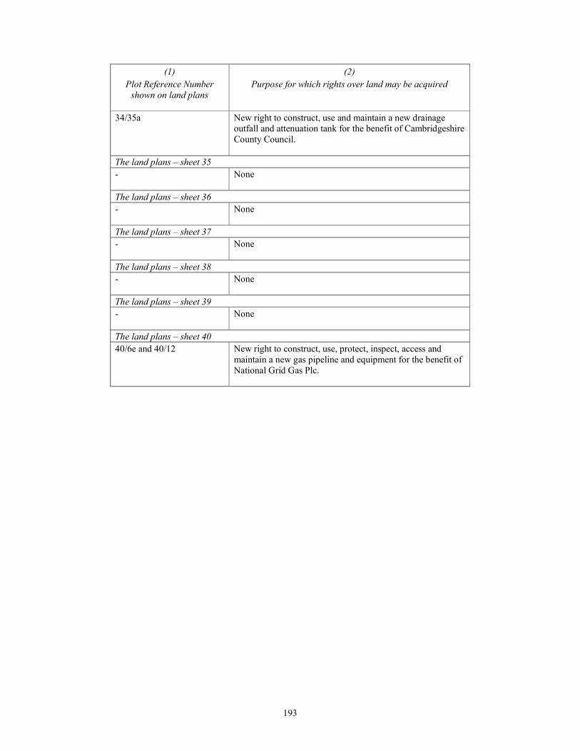
193
(1)
Plot Reference Number
shown on land plans
(2)
Purpose for which rights over land may be acquired
34/35a New right to construct, use and maintain a new drainage
outfall and attenuation tank for the benefit of Cambridgeshire
County Council.
The land plans – sheet 35
- None
The land plans – sheet 36
- None
The land plans – sheet 37
- None
The land plans – sheet 38
- None
The land plans – sheet 39
- None
The land plans – sheet 40
40/6e and 40/12 New right to construct, use, protect, inspect, access and
maintain a new gas pipeline and equipment for the benefit of
National Grid Gas Plc.
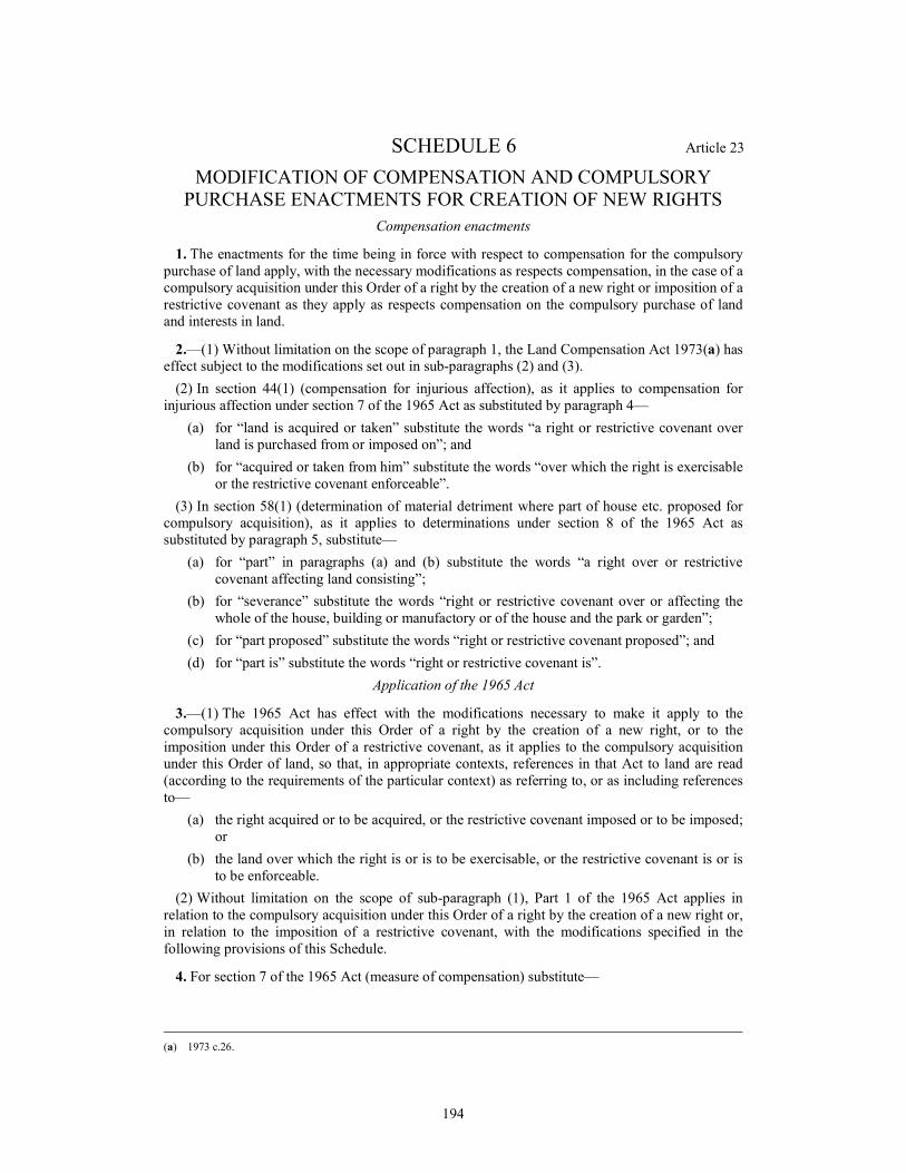
194
SCHEDULE 6 Article 23
MODIFICATION OF COMPENSATION AND COMPULSORY
PURCHASE ENACTMENTS FOR CREATION OF NEW RIGHTS
Compensation enactments
1. The enactments for the time being in force with respect to compensation for the compulsory
purchase of land apply, with the necessary modifications as respects compensation, in the case of a
compulsory acquisition under this Order of a right by the creation of a new right or imposition of a
restrictive covenant as they apply as respects compensation on the compulsory purchase of land
and interests in land.
2.—(1) Without limitation on the scope of paragraph 1, the Land Compensation Act 1973(a) has
effect subject to the modifications set out in sub-paragraphs (2) and (3).
(2) In section 44(1) (compensation for injurious affection), as it applies to compensation for
injurious affection under section 7 of the 1965 Act as substituted by paragraph 4—
(a) for “land is acquired or taken” substitute the words “a right or restrictive covenant over
land is purchased from or imposed on”; and
(b) for “acquired or taken from him” substitute the words “over which the right is exercisable
or the restrictive covenant enforceable”.
(3) In section 58(1) (determination of material detriment where part of house etc. proposed for
compulsory acquisition), as it applies to determinations under section 8 of the 1965 Act as
substituted by paragraph 5, substitute—
(a) for “part” in paragraphs (a) and (b) substitute the words “a right over or restrictive
covenant affecting land consisting”;
(b) for “severance” substitute the words “right or restrictive covenant over or affecting the
whole of the house, building or manufactory or of the house and the park or garden”;
(c) for “part proposed” substitute the words “right or restrictive covenant proposed”; and
(d) for “part is” substitute the words “right or restrictive covenant is”.
Application of the 1965 Act
3.—(1) The 1965 Act has effect with the modifications necessary to make it apply to the
compulsory acquisition under this Order of a right by the creation of a new right, or to the
imposition under this Order of a restrictive covenant, as it applies to the compulsory acquisition
under this Order of land, so that, in appropriate contexts, references in that Act to land are read
(according to the requirements of the particular context) as referring to, or as including references
to—
(a) the right acquired or to be acquired, or the restrictive covenant imposed or to be imposed;
or
(b) the land over which the right is or is to be exercisable, or the restrictive covenant is or is
to be enforceable.
(2) Without limitation on the scope of sub-paragraph (1), Part 1 of the 1965 Act applies in
relation to the compulsory acquisition under this Order of a right by the creation of a new right or,
in relation to the imposition of a restrictive covenant, with the modifications specified in the
following provisions of this Schedule.
4. For section 7 of the 1965 Act (measure of compensation) substitute—
(a) 1973 c.26.

195
“7. In assessing the compensation to be paid by the acquiring authority under this Act,
regard must be had not only to the extent (if any) to which the value of the land over which
the right is to be acquired or the restrictive covenant is to be imposed is depreciated by the
acquisition of the right or the imposition of the covenant but also to the damage (if any) to
be sustained by the owner of the land by reason of its severance from other land of the
owner, or injuriously affecting that other land by the exercise of the powers conferred by
this or the special Act.”.
5. For section 8 of the 1965 Act (provisions as to divided land) substitute—
“8.—(1) Where in consequence of the service on a person under section 5 of this Act of a
notice to treat in respect of a right over land consisting of a house, building or manufactory
or of a park or garden belonging to a house (“the relevant land”)—
(a) a question of disputed compensation in respect of the purchase of the right or the
imposition of the restrictive covenant would apart from this section fall to be
determined by the Upper Tribunal (“the tribunal”); and
(b) before the tribunal has determined that question the tribunal is satisfied that the
person has an interest in the whole of the relevant land and is able and willing to
sell that land and—
(i) where that land consists of a house, building or manufactory, that the right
cannot be purchased or the restrictive covenant imposed without material
detriment to that land; or
(ii) where that land consists of such a park or garden, that the right cannot be
purchased or the restrictive covenant imposed without seriously affecting the
amenity or convenience of the house to which that land belongs,
the A14 Cambridge to Huntingdon Improvement Scheme Development Consent Order 201[
](a) (“the Order”), in relation to that person, ceases to authorise the purchase of the right or
imposition of the restrictive covenant and is deemed to authorise the purchase of that
person’s interest in the whole of the relevant land including, where the land consists of such
a park or garden, the house to which it belongs, and the notice is deemed to have been
served in respect of that interest on such date as the tribunal directs.
(2) Any question as to the extent of the land in which the Order is deemed to authorise the
purchase of an interest by virtue of subsection (1) of this section is to be determined by the
tribunal.
(3) Where in consequence of a determination of the tribunal that it is satisfied as
mentioned in subsection (1) of this section the Order is deemed by virtue of that subsection
to authorise the purchase of an interest in land, the acquiring authority may, at any time
within the period of 6 weeks beginning with the date of the determination, withdraw the
notice to treat in consequence of which the determination was made; but nothing in this
subsection prejudices any other power of the authority to withdraw the notice.”.
6. The following provisions of the 1965 Act (which state the effect of a deed poll executed in
various circumstances where there is no conveyance by persons with interests in the land), that is
to say—
(a) section 9(4) (failure by owners to convey);
(b) paragraph 10(3) of Schedule 1 (owners under incapacity);
(c) paragraph 2(3) of Schedule 2 (absent and untraced owners); and
(d) paragraphs 2(3) and 7(2) of Schedule 4 (common land),
are modified so as to secure that, as against persons with interests in the land which are expressed
to be overridden by the deed, the right which is to be compulsorily acquired or the restrictive
covenant which is to be imposed is vested absolutely in the acquiring authority.
7. Section 11 (powers of entry) of the 1965 Act is modified so as to secure that, as from the date
on which the acquiring authority has served notice to treat in respect of any right it has power,

196
exercisable in equivalent circumstances and subject to equivalent conditions, to enter for the
purpose of exercising that right or enforcing that restrictive covenant (which is deemed for this
purpose to have been created on the date of service of the notice); and sections 12 (penalty for
unauthorised entry) and 13 (entry on warrant in the event of obstruction) of the 1965 Act are
modified correspondingly.
8. Section 20 (protection for interests of tenants at will, etc.) of the 1965 Act applies with the
modifications necessary to secure that persons with such interests in land as are mentioned in that
section are compensated in a manner corresponding to that in which they would be compensated
on a compulsory acquisition under this Order of that land, but taking into account only the extent
(if any) of such interference with such an interest as is actually caused, or likely to be caused, by
the exercise of the right or the enforcement of the restrictive covenant in question.
9. Section 22 (interests omitted from purchase) of the 1965 Act is modified as to enable the
acquiring authority, in circumstances corresponding to those referred to in that section, to continue
to be entitled to exercise the right acquired, subject to compliance with that section as respects
compensation.
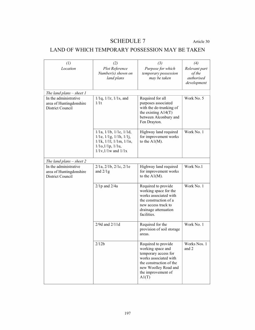
197
SCHEDULE 7 Article 30
LAND OF WHICH TEMPORARY POSSESSION MAY BE TAKEN
(1)
Location
(2)
Plot Reference
Number(s) shown on
land plans
(3)
Purpose for which
temporary possession
may be taken
(4)
Relevant part
of the
authorised
development
The land plans – sheet 1
In the administrative
area of Huntingdonshire
District Council
1/1q, 1/1r, 1/1s, and
1/1t
Required for all
purposes associated
with the de-trunking of
the existing A14(T)
between Alconbury and
Fen Drayton.
Work No. 5
1/1a, 1/1b, 1/1c, 1/1d,
1/1e, 1/1g, 1/1h, 1/1j,
1/1k, 1/1l, 1/1m, 1/1n,
1/1o,1/1p, 1/1u,
1/1v,1/1w and 1/1x
Highway land required
for improvement works
to the A1(M).
Work No. 1
The land plans – sheet 2
In the administrative
area of Huntingdonshire
District Council
2/1a, 2/1b, 2/1c, 2/1e
and 2/1g
Highway land required
for improvement works
to the A1(M).
Work No.1
2/1p and 2/4a Required to provide
working space for the
works associated with
the construction of a
new access track to
drainage attenuation
facilities.
Work No. 1
2/9d and 2/11d Required for the
provision of soil storage
areas.
Work No. 1
2/12b Required to provide
working space and
temporary access for
works associated with
the construction of the
new Woolley Road and
the improvement of
A1(T)
Works Nos. 1
and 2
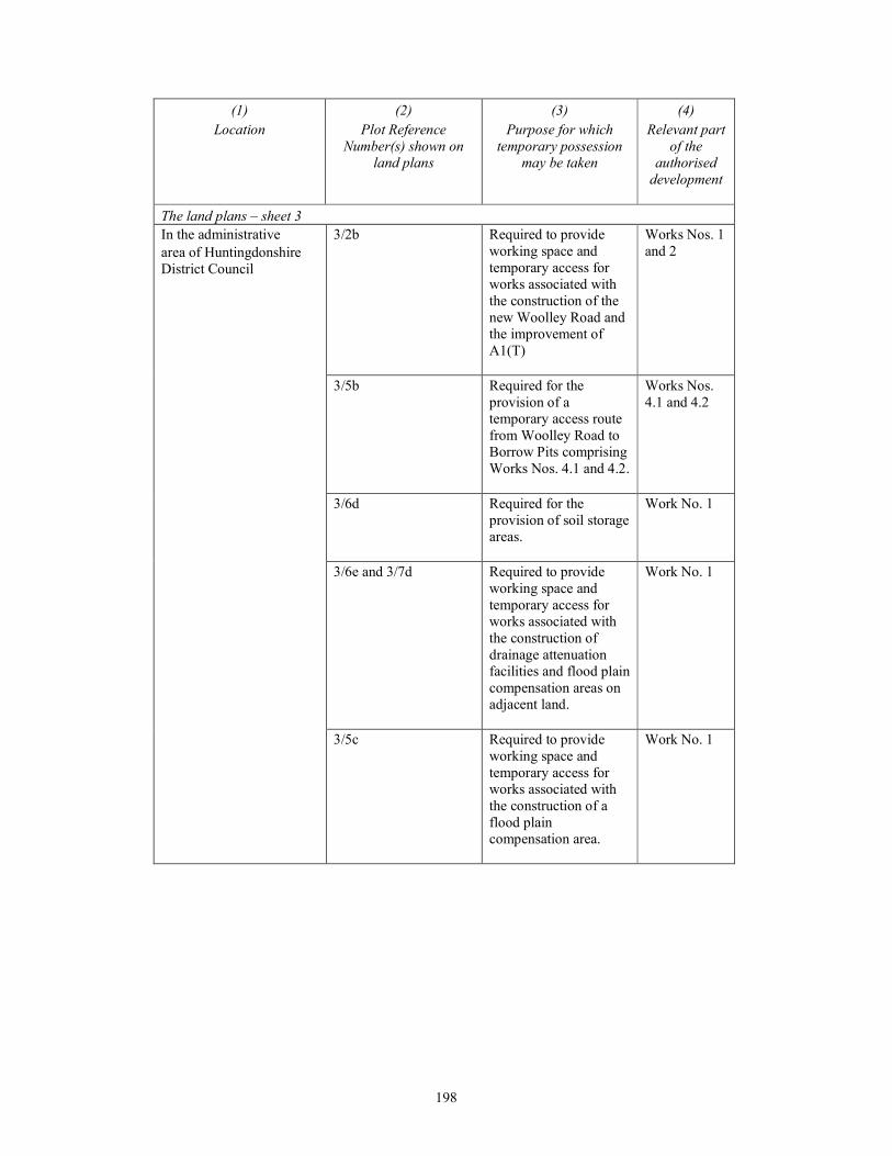
198
(1)
Location
(2)
Plot Reference
Number(s) shown on
land plans
(3)
Purpose for which
temporary possession
may be taken
(4)
Relevant part
of the
authorised
development
The land plans – sheet 3
In the administrative
area of Huntingdonshire
District Council
3/2b Required to provide
working space and
temporary access for
works associated with
the construction of the
new Woolley Road and
the improvement of
A1(T)
Works Nos. 1
and 2
3/5b Required for the
provision of a
temporary access route
from Woolley Road to
Borrow Pits comprising
Works Nos. 4.1 and 4.2.
Works Nos.
4.1 and 4.2
3/6d Required for the
provision of soil storage
areas.
Work No. 1
3/6e and 3/7d Required to provide
working space and
temporary access for
works associated with
the construction of
drainage attenuation
facilities and flood plain
compensation areas on
adjacent land.
Work No. 1
3/5c Required to provide
working space and
temporary access for
works associated with
the construction of a
flood plain
compensation area.
Work No. 1
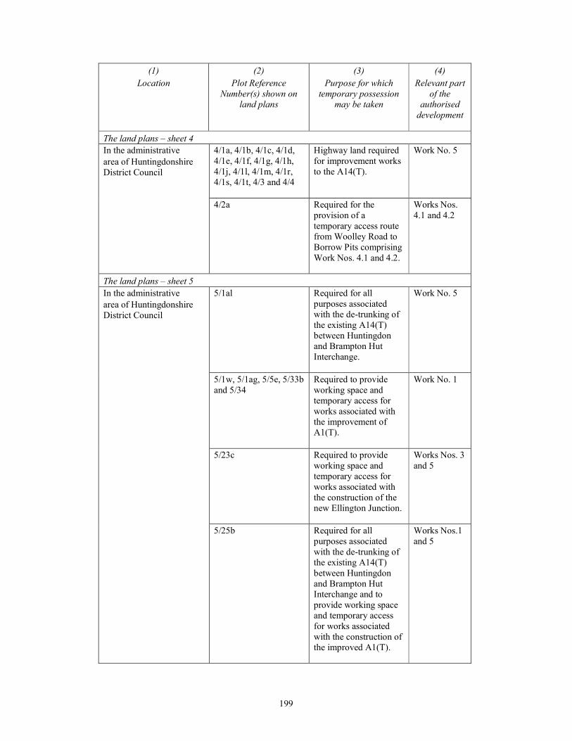
199
(1)
Location
(2)
Plot Reference
Number(s) shown on
land plans
(3)
Purpose for which
temporary possession
may be taken
(4)
Relevant part
of the
authorised
development
The land plans – sheet 4
In the administrative
area of Huntingdonshire
District Council
4/1a, 4/1b, 4/1c, 4/1d,
4/1e, 4/1f, 4/1g, 4/1h,
4/1j, 4/1l, 4/1m, 4/1r,
4/1s, 4/1t, 4/3 and 4/4
Highway land required
for improvement works
to the A14(T).
Work No. 5
4/2a Required for the
provision of a
temporary access route
from Woolley Road to
Borrow Pits comprising
Work Nos. 4.1 and 4.2.
Works Nos.
4.1 and 4.2
The land plans – sheet 5
In the administrative
area of Huntingdonshire
District Council
5/1al Required for all
purposes associated
with the de-trunking of
the existing A14(T)
between Huntingdon
and Brampton Hut
Interchange.
Work No. 5
5/1w, 5/1ag, 5/5e, 5/33b
and 5/34
Required to provide
working space and
temporary access for
works associated with
the improvement of
A1(T).
Work No. 1
5/23c Required to provide
working space and
temporary access for
works associated with
the construction of the
new Ellington Junction.
Works Nos. 3
and 5
5/25b Required for all
purposes associated
with the de-trunking of
the existing A14(T)
between Huntingdon
and Brampton Hut
Interchange and to
provide working space
and temporary access
for works associated
with the construction of
the improved A1(T).
Works Nos.1
and 5
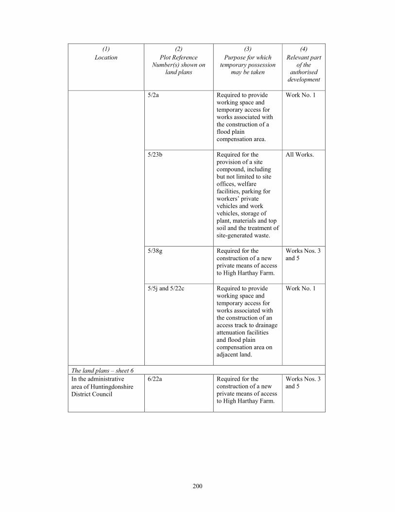
200
(1)
Location
(2)
Plot Reference
Number(s) shown on
land plans
(3)
Purpose for which
temporary possession
may be taken
(4)
Relevant part
of the
authorised
development
5/2a Required to provide
working space and
temporary access for
works associated with
the construction of a
flood plain
compensation area.
Work No. 1
5/23b Required for the
provision of a site
compound, including
but not limited to site
offices, welfare
facilities, parking for
workers’ private
vehicles and work
vehicles, storage of
plant, materials and top
soil and the treatment of
site-generated waste.
All Works.
5/38g Required for the
construction of a new
private means of access
to High Harthay Farm.
Works Nos. 3
and 5
5/5j and 5/22c Required to provide
working space and
temporary access for
works associated with
the construction of an
access track to drainage
attenuation facilities
and flood plain
compensation area on
adjacent land.
Work No. 1
The land plans – sheet 6
In the administrative
area of Huntingdonshire
District Council
6/22a Required for the
construction of a new
private means of access
to High Harthay Farm.
Works Nos. 3
and 5
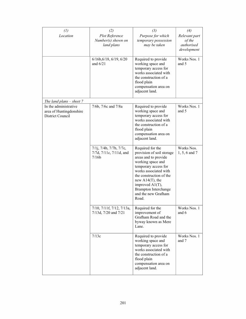
201
(1)
Location
(2)
Plot Reference
Number(s) shown on
land plans
(3)
Purpose for which
temporary possession
may be taken
(4)
Relevant part
of the
authorised
development
6/16b,6/18, 6/19, 6/20
and 6/21
Required to provide
working space and
temporary access for
works associated with
the construction of a
flood plain
compensation area on
adjacent land.
Works Nos. 1
and 5
The land plans – sheet 7
In the administrative
area of Huntingdonshire
District Council
7/6b, 7/6c and 7/8a Required to provide
working space and
temporary access for
works associated with
the construction of a
flood plain
compensation area on
adjacent land.
Works Nos. 1
and 5
7/1j, 7/4b, 7/7b, 7/7c,
7/7d, 7/11c, 7/11d, and
7/16b
Required for the
provision of soil storage
areas and to provide
working space and
temporary access for
works associated with
the construction of the
new A14(T), the
improved A1(T),
Brampton Interchange
and the new Grafham
Road.
Works Nos.
1, 5, 6 and 7
7/10, 7/11f, 7/12, 7/13a,
7/13d, 7/20 and 7/21
Required for the
improvement of
Grafham Road and the
byway known as Mere
Lane.
Works Nos. 1
and 6
7/13c Required to provide
working space and
temporary access for
works associated with
the construction of a
flood plain
compensation area on
adjacent land.
Works Nos. 1
and 7
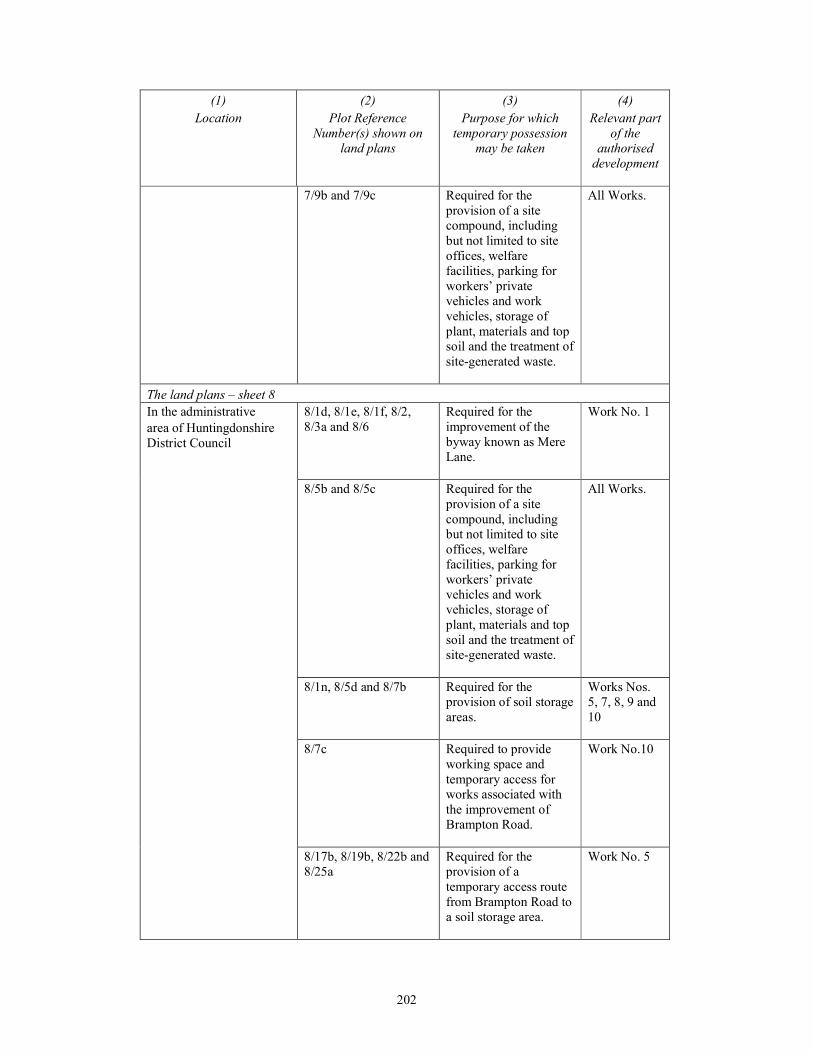
202
(1)
Location
(2)
Plot Reference
Number(s) shown on
land plans
(3)
Purpose for which
temporary possession
may be taken
(4)
Relevant part
of the
authorised
development
7/9b and 7/9c Required for the
provision of a site
compound, including
but not limited to site
offices, welfare
facilities, parking for
workers’ private
vehicles and work
vehicles, storage of
plant, materials and top
soil and the treatment of
site-generated waste.
All Works.
The land plans – sheet 8
In the administrative
area of Huntingdonshire
District Council
8/1d, 8/1e, 8/1f, 8/2,
8/3a and 8/6
Required for the
improvement of the
byway known as Mere
Lane.
Work No. 1
8/5b and 8/5c Required for the
provision of a site
compound, including
but not limited to site
offices, welfare
facilities, parking for
workers’ private
vehicles and work
vehicles, storage of
plant, materials and top
soil and the treatment of
site-generated waste.
All Works.
8/1n, 8/5d and 8/7b Required for the
provision of soil storage
areas.
Works Nos.
5, 7, 8, 9 and
10
8/7c Required to provide
working space and
temporary access for
works associated with
the improvement of
Brampton Road.
Work No.10
8/17b, 8/19b, 8/22b and
8/25a
Required for the
provision of a
temporary access route
from Brampton Road to
a soil storage area.
Work No. 5

203
(1)
Location
(2)
Plot Reference
Number(s) shown on
land plans
(3)
Purpose for which
temporary possession
may be taken
(4)
Relevant part
of the
authorised
development
8/21e and 8/21m Required for the
provision of soil storage
areas and to provide
working space and
temporary access for
works associated with
the construction of the
new A14(T).
Work No. 5
8/21c and 8/21b Required to provide
working space and
temporary access for
works associated with
the improvement of a
private means of access
to Lodge Farm.
Works No. 5
8/21h Required to provide
working space and
temporary access for
works associated with
the improvement of an
access track on adjacent
land and for works
associated with the
construction of flood
compensation areas on
adjacent land.
Works Nos. 5
and 10
8/21j and 8/31b Required to provide
working space and
temporary access for
works associated with
the construction of
flood compensation
areas on adjacent land.
Works Nos. 5
and 10
8/32a and 8/32b Required to provide
working space and
temporary access for
works associated with
the provision of
environmental
mitigation.
Work No. 5
The land plans – sheet 9
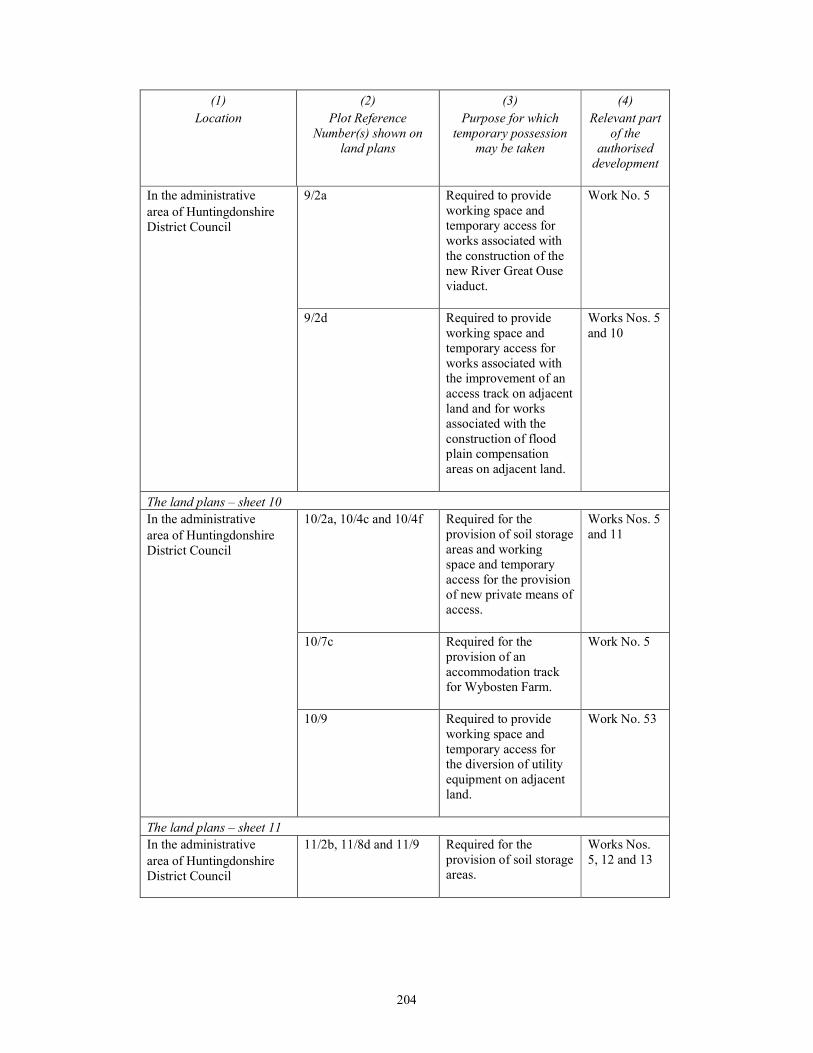
204
(1)
Location
(2)
Plot Reference
Number(s) shown on
land plans
(3)
Purpose for which
temporary possession
may be taken
(4)
Relevant part
of the
authorised
development
In the administrative
area of Huntingdonshire
District Council
9/2a Required to provide
working space and
temporary access for
works associated with
the construction of the
new River Great Ouse
viaduct.
Work No. 5
9/2d Required to provide
working space and
temporary access for
works associated with
the improvement of an
access track on adjacent
land and for works
associated with the
construction of flood
plain compensation
areas on adjacent land.
Works Nos. 5
and 10
The land plans – sheet 10
In the administrative
area of Huntingdonshire
District Council
10/2a, 10/4c and 10/4f Required for the
provision of soil storage
areas and working
space and temporary
access for the provision
of new private means of
access.
Works Nos. 5
and 11
10/7c Required for the
provision of an
accommodation track
for Wybosten Farm.
Work No. 5
10/9 Required to provide
working space and
temporary access for
the diversion of utility
equipment on adjacent
land.
Work No. 53
The land plans – sheet 11
In the administrative
area of Huntingdonshire
District Council
11/2b, 11/8d and 11/9 Required for the
provision of soil storage
areas.
Works Nos.
5, 12 and 13
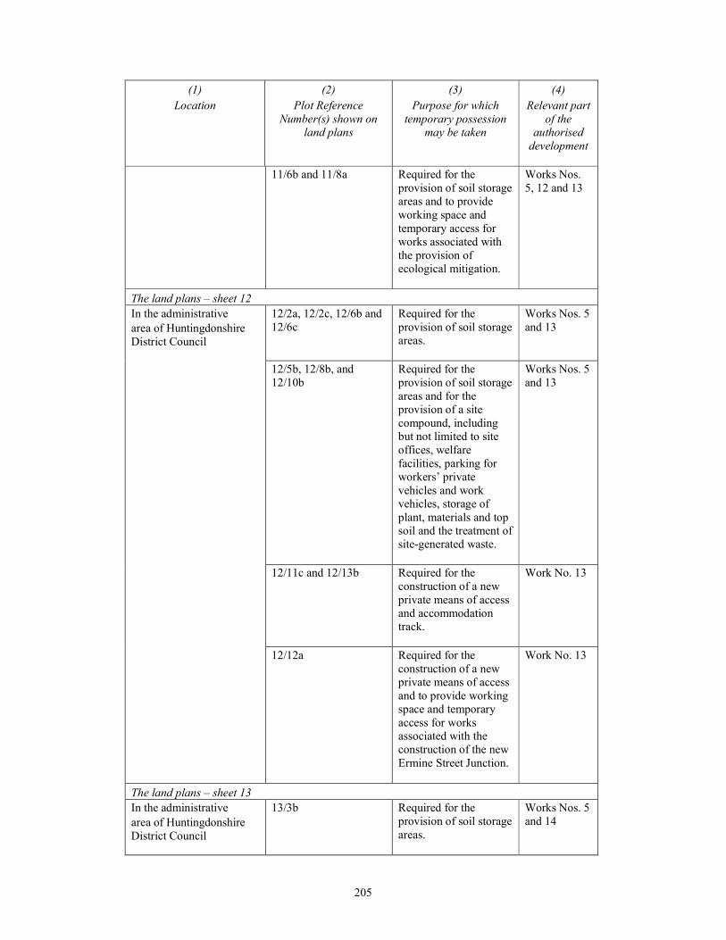
205
(1)
Location
(2)
Plot Reference
Number(s) shown on
land plans
(3)
Purpose for which
temporary possession
may be taken
(4)
Relevant part
of the
authorised
development
11/6b and 11/8a Required for the
provision of soil storage
areas and to provide
working space and
temporary access for
works associated with
the provision of
ecological mitigation.
Works Nos.
5, 12 and 13
The land plans – sheet 12
In the administrative
area of Huntingdonshire
District Council
12/2a, 12/2c, 12/6b and
12/6c
Required for the
provision of soil storage
areas.
Works Nos. 5
and 13
12/5b, 12/8b, and
12/10b
Required for the
provision of soil storage
areas and for the
provision of a site
compound, including
but not limited to site
offices, welfare
facilities, parking for
workers’ private
vehicles and work
vehicles, storage of
plant, materials and top
soil and the treatment of
site-generated waste.
Works Nos. 5
and 13
12/11c and 12/13b Required for the
construction of a new
private means of access
and accommodation
track.
Work No. 13
12/12a Required for the
construction of a new
private means of access
and to provide working
space and temporary
access for works
associated with the
construction of the new
Ermine Street Junction.
Work No. 13
The land plans – sheet 13
In the administrative
area of Huntingdonshire
District Council
13/3b Required for the
provision of soil storage
areas.
Works Nos. 5
and 14
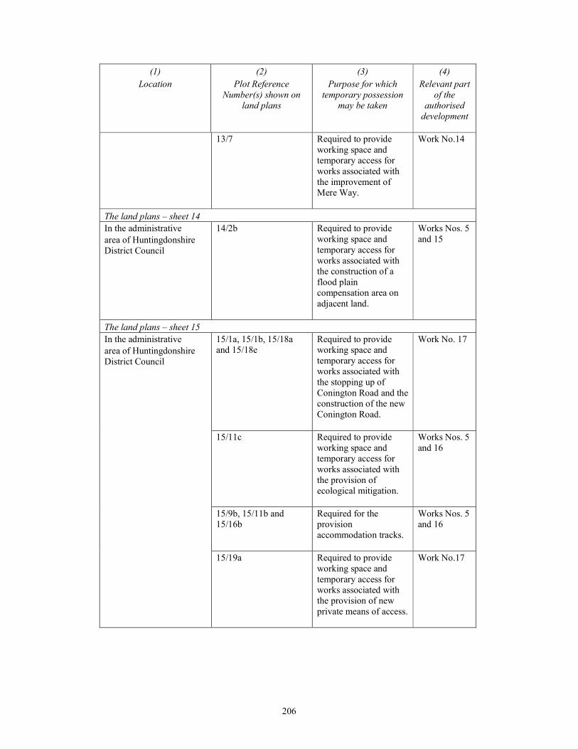
206
(1)
Location
(2)
Plot Reference
Number(s) shown on
land plans
(3)
Purpose for which
temporary possession
may be taken
(4)
Relevant part
of the
authorised
development
13/7 Required to provide
working space and
temporary access for
works associated with
the improvement of
Mere Way.
Work No.14
The land plans – sheet 14
In the administrative
area of Huntingdonshire
District Council
14/2b Required to provide
working space and
temporary access for
works associated with
the construction of a
flood plain
compensation area on
adjacent land.
Works Nos. 5
and 15
The land plans – sheet 15
In the administrative
area of Huntingdonshire
District Council
15/1a, 15/1b, 15/18a
and 15/18e
Required to provide
working space and
temporary access for
works associated with
the stopping up of
Conington Road and the
construction of the new
Conington Road.
Work No. 17
15/11c Required to provide
working space and
temporary access for
works associated with
the provision of
ecological mitigation.
Works Nos. 5
and 16
15/9b, 15/11b and
15/16b
Required for the
provision
accommodation tracks.
Works Nos. 5
and 16
15/19a Required to provide
working space and
temporary access for
works associated with
the provision of new
private means of access.
Work No.17
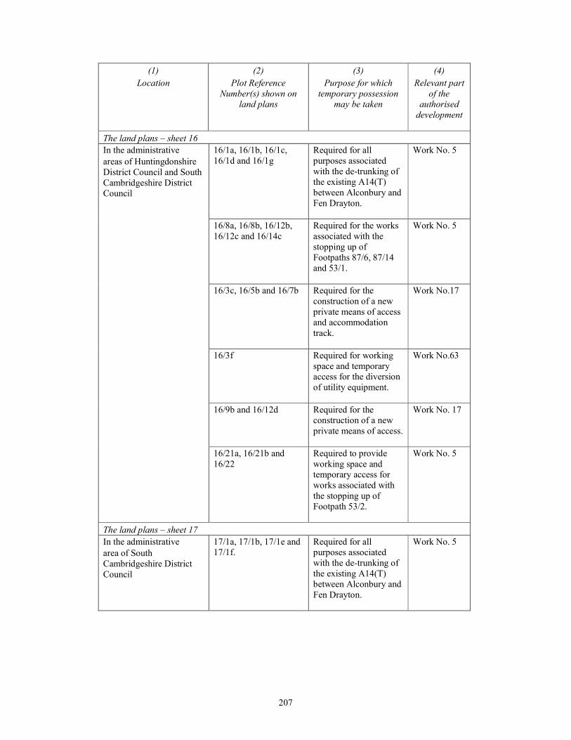
207
(1)
Location
(2)
Plot Reference
Number(s) shown on
land plans
(3)
Purpose for which
temporary possession
may be taken
(4)
Relevant part
of the
authorised
development
The land plans – sheet 16
In the administrative
areas of Huntingdonshire
District Council and South
Cambridgeshire District
Council
16/1a, 16/1b, 16/1c,
16/1d and 16/1g
Required for all
purposes associated
with the de-trunking of
the existing A14(T)
between Alconbury and
Fen Drayton.
Work No. 5
16/8a, 16/8b, 16/12b,
16/12c and 16/14c
Required for the works
associated with the
stopping up of
Footpaths 87/6, 87/14
and 53/1.
Work No. 5
16/3c, 16/5b and 16/7b Required for the
construction of a new
private means of access
and accommodation
track.
Work No.17
16/3f Required for working
space and temporary
access for the diversion
of utility equipment.
Work No.63
16/9b and 16/12d Required for the
construction of a new
private means of access.
Work No. 17
16/21a, 16/21b and
16/22
Required to provide
working space and
temporary access for
works associated with
the stopping up of
Footpath 53/2.
Work No. 5
The land plans – sheet 17
In the administrative
area of South
Cambridgeshire District
Council
17/1a, 17/1b, 17/1e and
17/1f.
Required for all
purposes associated
with the de-trunking of
the existing A14(T)
between Alconbury and
Fen Drayton.
Work No. 5
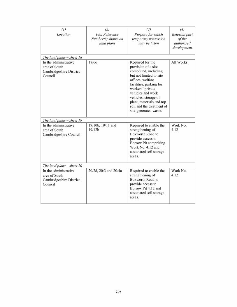
208
(1)
Location
(2)
Plot Reference
Number(s) shown on
land plans
(3)
Purpose for which
temporary possession
may be taken
(4)
Relevant part
of the
authorised
development
The land plans – sheet 18
In the administrative
area of South
Cambridgeshire District
Council
18/6e Required for the
provision of a site
compound, including
but not limited to site
offices, welfare
facilities, parking for
workers’ private
vehicles and work
vehicles, storage of
plant, materials and top
soil and the treatment of
site-generated waste.
All Works.
The land plans – sheet 19
In the administrative
area of South
Cambridgeshire Council
19/10b, 19/11 and
19/12b
Required to enable the
strengthening of
Boxworth Road to
provide access to
Borrow Pit comprising
Work No. 4.12 and
associated soil storage
areas.
Work No.
4.12
The land plans – sheet 20
In the administrative
area of South
Cambridgeshire District
Council
20/2d, 20/3 and 20/4a Required to enable the
strengthening of
Boxworth Road to
provide access to
Borrow Pit 4.12 and
associated soil storage
areas.
Work No.
4.12
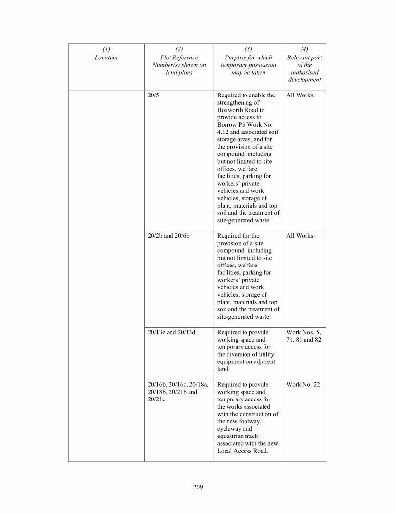
209
(1)
Location
(2)
Plot Reference
Number(s) shown on
land plans
(3)
Purpose for which
temporary possession
may be taken
(4)
Relevant part
of the
authorised
development
20/5 Required to enable the
strengthening of
Boxworth Road to
provide access to
Borrow Pit Work No.
4.12 and associated soil
storage areas, and for
the provision of a site
compound, including
but not limited to site
offices, welfare
facilities, parking for
workers’ private
vehicles and work
vehicles, storage of
plant, materials and top
soil and the treatment of
site-generated waste.
All Works.
20/2b and 20/6b Required for the
provision of a site
compound, including
but not limited to site
offices, welfare
facilities, parking for
workers’ private
vehicles and work
vehicles, storage of
plant, materials and top
soil and the treatment of
site-generated waste.
All Works.
20/13e and 20/13d Required to provide
working space and
temporary access for
the diversion of utility
equipment on adjacent
land.
Work Nos. 5,
71, 81 and 82
20/16b, 20/16c, 20/18a,
20/18b, 20/21b and
20/21c
Required to provide
working space and
temporary access for
the works associated
with the construction of
the new footway,
cycleway and
equestrian track
associated with the new
Local Access Road.
Work No. 22
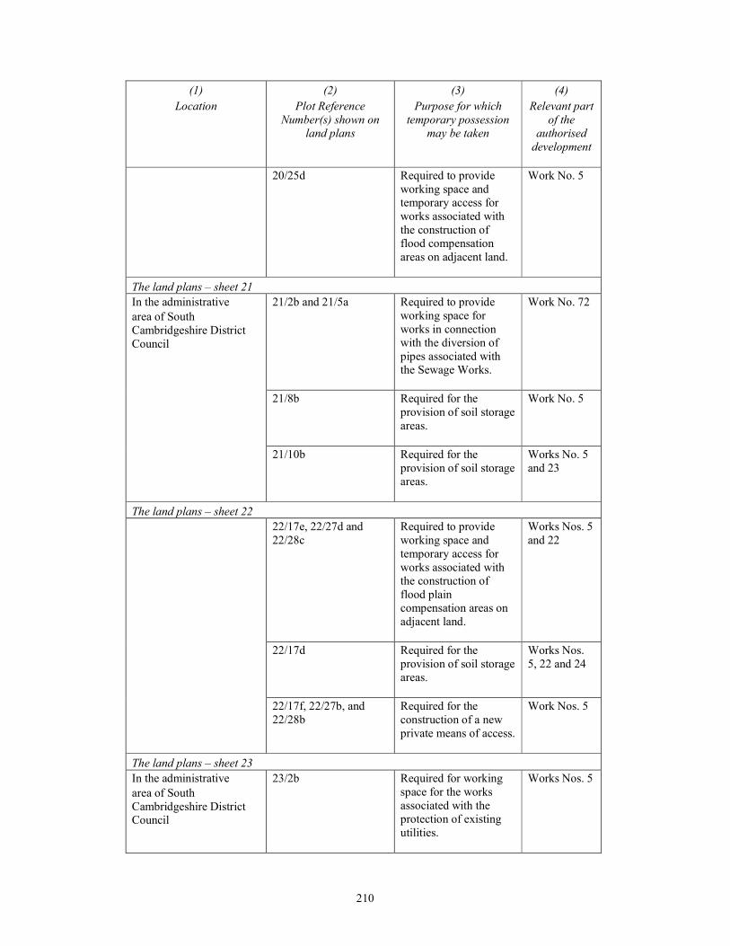
210
(1)
Location
(2)
Plot Reference
Number(s) shown on
land plans
(3)
Purpose for which
temporary possession
may be taken
(4)
Relevant part
of the
authorised
development
20/25d Required to provide
working space and
temporary access for
works associated with
the construction of
flood compensation
areas on adjacent land.
Work No. 5
The land plans – sheet 21
In the administrative
area of South
Cambridgeshire District
Council
21/2b and 21/5a Required to provide
working space for
works in connection
with the diversion of
pipes associated with
the Sewage Works.
Work No. 72
21/8b Required for the
provision of soil storage
areas.
Work No. 5
21/10b Required for the
provision of soil storage
areas.
Works No. 5
and 23
The land plans – sheet 22
22/17e, 22/27d and
22/28c
Required to provide
working space and
temporary access for
works associated with
the construction of
flood plain
compensation areas on
adjacent land.
Works Nos. 5
and 22
22/17d Required for the
provision of soil storage
areas.
Works Nos.
5, 22 and 24
22/17f, 22/27b, and
22/28b
Required for the
construction of a new
private means of access.
Work Nos. 5
The land plans – sheet 23
In the administrative
area of South
Cambridgeshire District
Council
23/2b Required for working
space for the works
associated with the
protection of existing
utilities.
Works Nos. 5
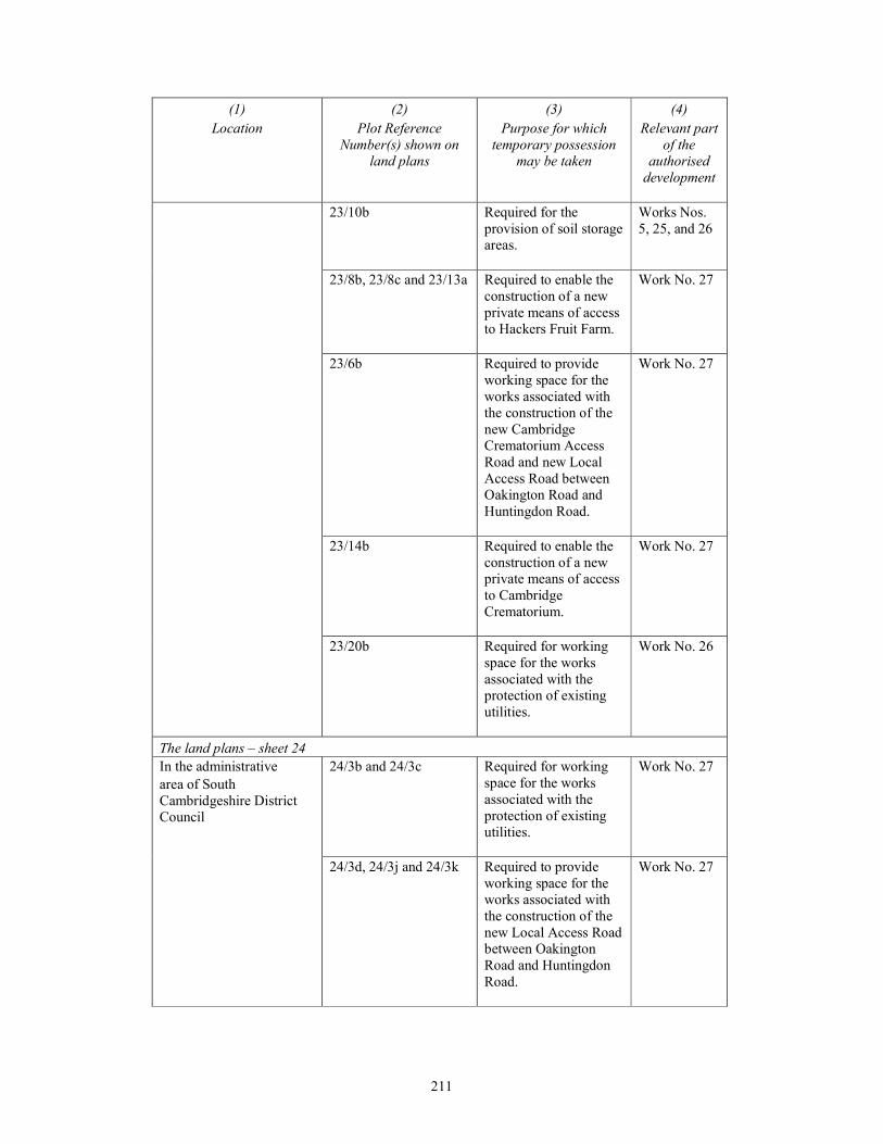
211
(1)
Location
(2)
Plot Reference
Number(s) shown on
land plans
(3)
Purpose for which
temporary possession
may be taken
(4)
Relevant part
of the
authorised
development
23/10b Required for the
provision of soil storage
areas.
Works Nos.
5, 25, and 26
23/8b, 23/8c and 23/13a Required to enable the
construction of a new
private means of access
to Hackers Fruit Farm.
Work No. 27
23/6b Required to provide
working space for the
works associated with
the construction of the
new Cambridge
Crematorium Access
Road and new Local
Access Road between
Oakington Road and
Huntingdon Road.
Work No. 27
23/14b Required to enable the
construction of a new
private means of access
to Cambridge
Crematorium.
Work No. 27
23/20b Required for working
space for the works
associated with the
protection of existing
utilities.
Work No. 26
The land plans – sheet 24
In the administrative
area of South
Cambridgeshire District
Council
24/3b and 24/3c Required for working
space for the works
associated with the
protection of existing
utilities.
Work No. 27
24/3d, 24/3j and 24/3k Required to provide
working space for the
works associated with
the construction of the
new Local Access Road
between Oakington
Road and Huntingdon
Road.
Work No. 27
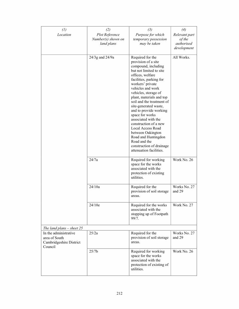
212
(1)
Location
(2)
Plot Reference
Number(s) shown on
land plans
(3)
Purpose for which
temporary possession
may be taken
(4)
Relevant part
of the
authorised
development
24/3g and 24/9a Required for the
provision of a site
compound, including
but not limited to site
offices, welfare
facilities, parking for
workers’ private
vehicles and work
vehicles, storage of
plant, materials and top
soil and the treatment of
site-generated waste,
and to provide working
space for works
associated with the
construction of a new
Local Access Road
between Oakington
Road and Huntingdon
Road and the
construction of drainage
attenuation facilities.
All Works.
24/7a Required for working
space for the works
associated with the
protection of existing
utilities.
Work No. 26
24/10a Required for the
provision of soil storage
areas.
Works No. 27
and 29
24/10e Required for the works
associated with the
stopping up of Footpath
99/7.
Work No. 27
The land plans – sheet 25
In the administrative
area of South
Cambridgeshire District
Council
25/2a Required for the
provision of soil storage
areas.
Works No. 27
and 29
25/7b Required for working
space for the works
associated with the
protection of existing of
utilities.
Work No. 26
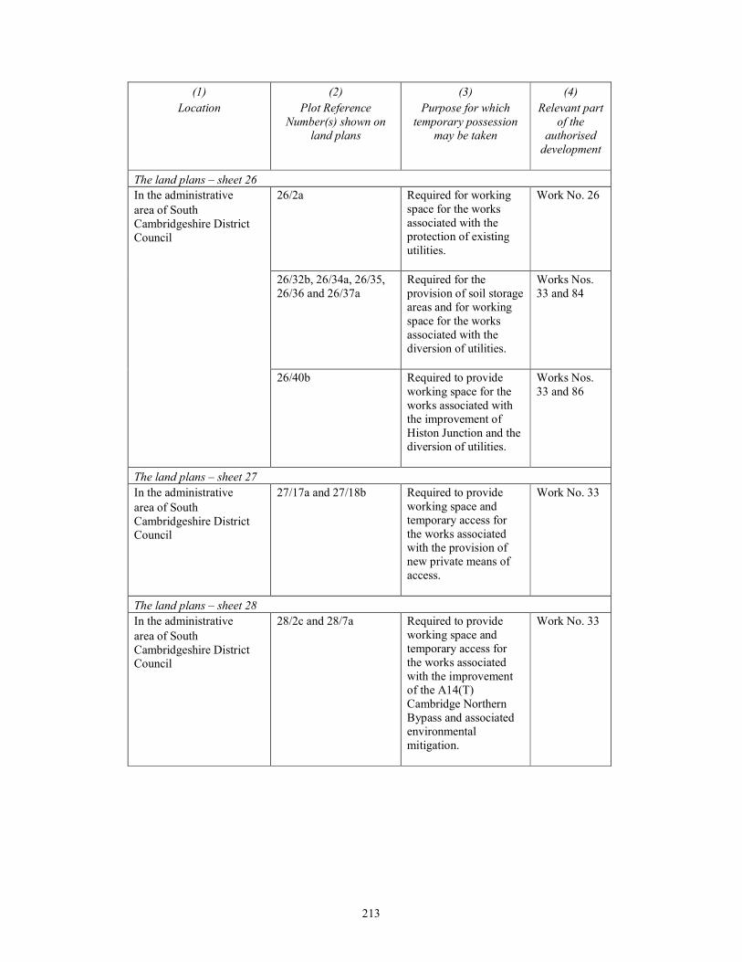
213
(1)
Location
(2)
Plot Reference
Number(s) shown on
land plans
(3)
Purpose for which
temporary possession
may be taken
(4)
Relevant part
of the
authorised
development
The land plans – sheet 26
In the administrative
area of South
Cambridgeshire District
Council
26/2a Required for working
space for the works
associated with the
protection of existing
utilities.
Work No. 26
26/32b, 26/34a, 26/35,
26/36 and 26/37a
Required for the
provision of soil storage
areas and for working
space for the works
associated with the
diversion of utilities.
Works Nos.
33 and 84
26/40b Required to provide
working space for the
works associated with
the improvement of
Histon Junction and the
diversion of utilities.
Works Nos.
33 and 86
The land plans – sheet 27
In the administrative
area of South
Cambridgeshire District
Council
27/17a and 27/18b Required to provide
working space and
temporary access for
the works associated
with the provision of
new private means of
access.
Work No. 33
The land plans – sheet 28
In the administrative
area of South
Cambridgeshire District
Council
28/2c and 28/7a Required to provide
working space and
temporary access for
the works associated
with the improvement
of the A14(T)
Cambridge Northern
Bypass and associated
environmental
mitigation.
Work No. 33
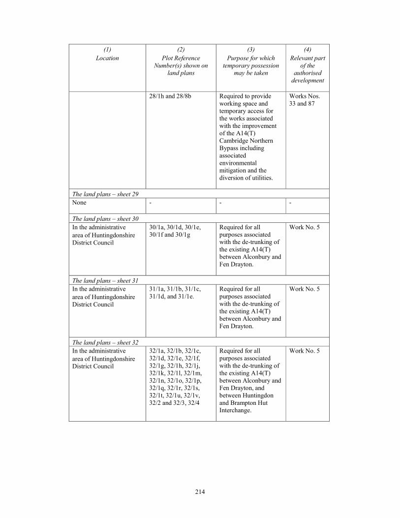
214
(1)
Location
(2)
Plot Reference
Number(s) shown on
land plans
(3)
Purpose for which
temporary possession
may be taken
(4)
Relevant part
of the
authorised
development
28/1h and 28/8b Required to provide
working space and
temporary access for
the works associated
with the improvement
of the A14(T)
Cambridge Northern
Bypass including
associated
environmental
mitigation and the
diversion of utilities.
Works Nos.
33 and 87
The land plans – sheet 29
None
- - -
The land plans – sheet 30
In the administrative
area of Huntingdonshire
District Council
30/1a, 30/1d, 30/1e,
30/1f and 30/1g
Required for all
purposes associated
with the de-trunking of
the existing A14(T)
between Alconbury and
Fen Drayton.
Work No. 5
The land plans – sheet 31
In the administrative
area of Huntingdonshire
District Council
31/1a, 31/1b, 31/1c,
31/1d, and 31/1e.
Required for all
purposes associated
with the de-trunking of
the existing A14(T)
between Alconbury and
Fen Drayton.
Work No. 5
The land plans – sheet 32
In the administrative
area of Huntingdonshire
District Council
32/1a, 32/1b, 32/1c,
32/1d, 32/1e, 32/1f,
32/1g, 32/1h, 32/1j,
32/1k, 32/1l, 32/1m,
32/1n, 32/1o, 32/1p,
32/1q, 32/1r, 32/1s,
32/1t, 32/1u, 32/1v,
32/2 and 32/3, 32/4
Required for all
purposes associated
with the de-trunking of
the existing A14(T)
between Alconbury and
Fen Drayton, and
between Huntingdon
and Brampton Hut
Interchange.
Work No. 5
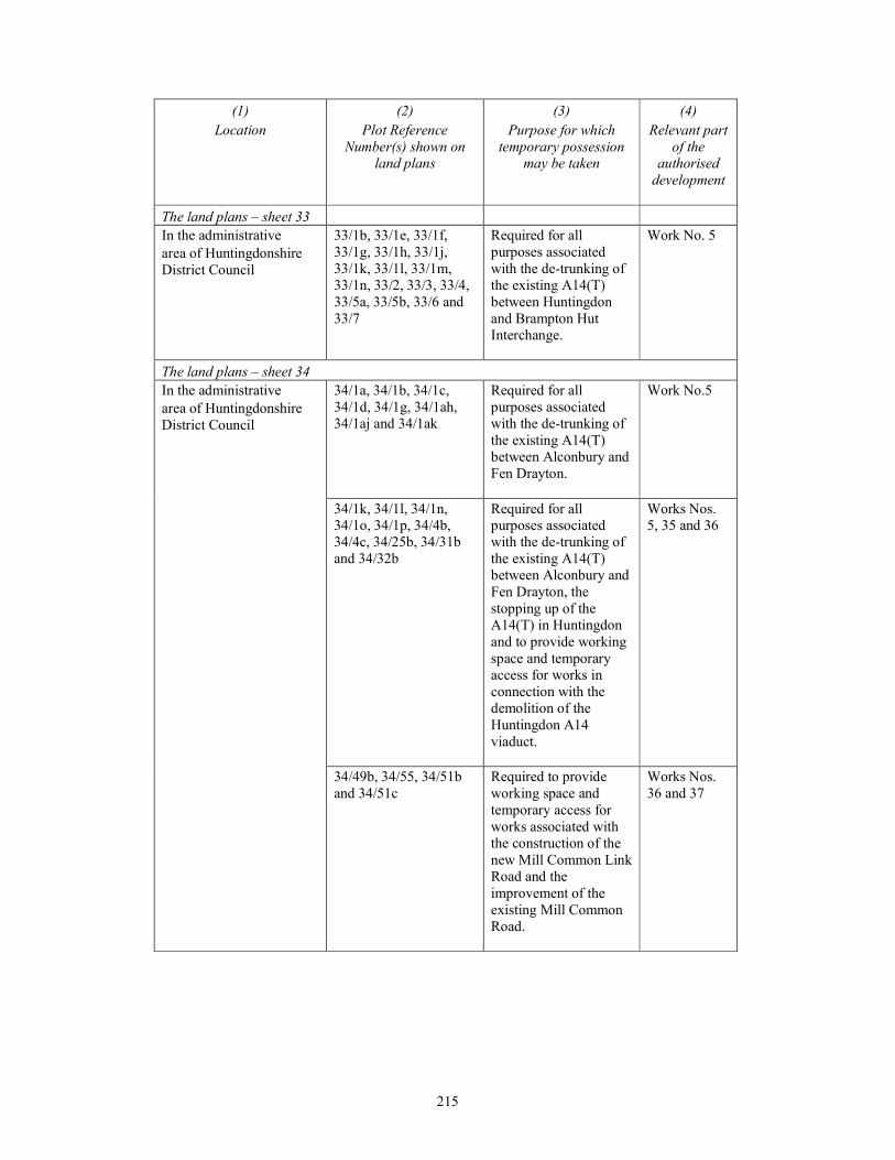
215
(1)
Location
(2)
Plot Reference
Number(s) shown on
land plans
(3)
Purpose for which
temporary possession
may be taken
(4)
Relevant part
of the
authorised
development
The land plans – sheet 33
In the administrative
area of Huntingdonshire
District Council
33/1b, 33/1e, 33/1f,
33/1g, 33/1h, 33/1j,
33/1k, 33/1l, 33/1m,
33/1n, 33/2, 33/3, 33/4,
33/5a, 33/5b, 33/6 and
33/7
Required for all
purposes associated
with the de-trunking of
the existing A14(T)
between Huntingdon
and Brampton Hut
Interchange.
Work No. 5
The land plans – sheet 34
In the administrative
area of Huntingdonshire
District Council
34/1a, 34/1b, 34/1c,
34/1d, 34/1g, 34/1ah,
34/1aj and 34/1ak
Required for all
purposes associated
with the de-trunking of
the existing A14(T)
between Alconbury and
Fen Drayton.
Work No.5
34/1k, 34/1l, 34/1n,
34/1o, 34/1p, 34/4b,
34/4c, 34/25b, 34/31b
and 34/32b
Required for all
purposes associated
with the de-trunking of
the existing A14(T)
between Alconbury and
Fen Drayton, the
stopping up of the
A14(T) in Huntingdon
and to provide working
space and temporary
access for works in
connection with the
demolition of the
Huntingdon A14
viaduct.
Works Nos.
5, 35 and 36
34/49b, 34/55, 34/51b
and 34/51c
Required to provide
working space and
temporary access for
works associated with
the construction of the
new Mill Common Link
Road and the
improvement of the
existing Mill Common
Road.
Works Nos.
36 and 37
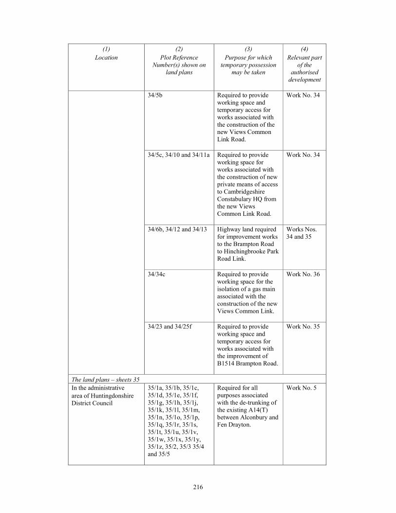
216
(1)
Location
(2)
Plot Reference
Number(s) shown on
land plans
(3)
Purpose for which
temporary possession
may be taken
(4)
Relevant part
of the
authorised
development
34/5b Required to provide
working space and
temporary access for
works associated with
the construction of the
new Views Common
Link Road.
Work No. 34
34/5c, 34/10 and 34/11a Required to provide
working space for
works associated with
the construction of new
private means of access
to Cambridgeshire
Constabulary HQ from
the new Views
Common Link Road.
Work No. 34
34/6b, 34/12 and 34/13 Highway land required
for improvement works
to the Brampton Road
to Hinchingbrooke Park
Road Link.
Works Nos.
34 and 35
34/34c Required to provide
working space for the
isolation of a gas main
associated with the
construction of the new
Views Common Link.
Work No. 36
34/23 and 34/25f Required to provide
working space and
temporary access for
works associated with
the improvement of
B1514 Brampton Road.
Work No. 35
The land plans – sheets 35
In the administrative
area of Huntingdonshire
District Council
35/1a, 35/1b, 35/1c,
35/1d, 35/1e, 35/1f,
35/1g, 35/1h, 35/1j,
35/1k, 35/1l, 35/1m,
35/1n, 35/1o, 35/1p,
35/1q, 35/1r, 35/1s,
35/1t, 35/1u, 35/1v,
35/1w, 35/1x, 35/1y,
35/1z, 35/2, 35/3 35/4
and 35/5
Required for all
purposes associated
with the de-trunking of
the existing A14(T)
between Alconbury and
Fen Drayton.
Work No. 5
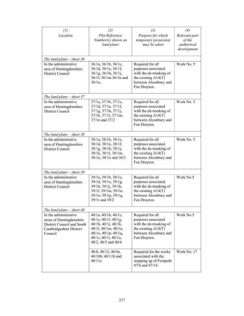
217
(1)
Location
(2)
Plot Reference
Number(s) shown on
land plans
(3)
Purpose for which
temporary possession
may be taken
(4)
Relevant part
of the
authorised
development
The land plans – sheet 36
In the administrative
area of Huntingdonshire
District Council
36/1a, 36/1b, 36/1c,
36/1d, 36/1e, 36/1f,
36/1g, 36/1h, 36/1j,
36/1l, 36/1m 36/1n and
36/1o,
Required for all
purposes associated
with the de-trunking of
the existing A14(T)
between Alconbury and
Fen Drayton.
Work No. 5
The land plans – sheet 37
In the administrative
area of Huntingdonshire
District Council
37/1a, 37/1b, 37/1c,
37/1d, 37/1e, 37/1f,
37/1g, 37/1h, 37/1j,
37/1k, 37/1l, 37/1m,
37/1n and 37/2
Required for all
purposes associated
with the de-trunking of
the existing A14(T)
between Alconbury and
Fen Drayton.
Work No. 5
The land plans – sheet 38
In the administrative
area of Huntingdonshire
District Council
38/1a, 38/1b, 38/1c,
38/1d, 38/1e, 38/1f,
38/1g, 38/1h, 38/1j,
38/1k, 38/1l, 38/1m,
38/1n, 38/1o and 38/2
Required for all
purposes associated
with the de-trunking of
the existing A14(T)
between Alconbury and
Fen Drayton.
Work No. 5
The land plans – sheet 39
In the administrative
area of Huntingdonshire
District Council
39/1a, 39/1b, 39/1c,
39/1d, 39/1e, 39/1g,
39/1h, 39/1j, 39/1k,
39/1l, 39/1m, 39/1n,
39/1o, 39/1p, 39/1q,
39/1r and 39/2
Required for all
purposes associated
with the de-trunking of
the existing A14(T)
between Alconbury and
Fen Drayton.
Work No.5
The land plans – sheet 40
In the administrative
areas of Huntingdonshire
District Council and South
Cambridgeshire District
Council
40/1a, 40/1b, 40/1c,
40/1e, 40/1f, 40/1g,
40/1h, 40/1j, 40/1k,
40/1l, 40/1m, 40/1n,
40/1o, 40/1p, 40/1q,
40/1s, 40/1t, 40/1u,
40/2, 40/3 and 40/4
Required for all
purposes associated
with the de-trunking of
the existing A14(T)
between Alconbury and
Fen Drayton.
Work No.5
40/8, 40/12, 40/9a,
40/10b, 40/11b and
40/11c
Required for the works
associated with the
stopping up of Footpath
87/6 and 87/14.
Work No. 17
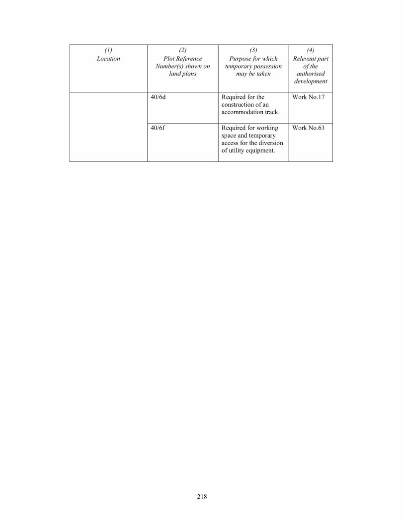
218
(1)
Location
(2)
Plot Reference
Number(s) shown on
land plans
(3)
Purpose for which
temporary possession
may be taken
(4)
Relevant part
of the
authorised
development
40/6d Required for the
construction of an
accommodation track.
Work No.17
40/6f Required for working
space and temporary
access for the diversion
of utility equipment.
Work No.63
219
SCHEDULE 8 Article 40
PROTECTIVE PROVISIONS
PART 1
FOR THE PROTECTION OF ELECTRICITY, GAS, OIL, WATER AND
SEWERAGE UNDERTAKERS
1. For the protection of the statutory undertakers referred to in this Part of this Schedule the
following provisions have effect, unless otherwise agreed in writing between the undertaker and
the statutory undertaker concerned.
2. In this Part of this Schedule—
“alternative apparatus” means alternative apparatus adequate to enable the statutory
undertaker in question to fulfil its statutory functions in a manner no less efficient than
previously;
“apparatus” means—
(a) in the case of an electricity undertaker, electric lines or electrical plant (as defined in the
Electricity Act 1989(a)), belonging to or maintained by that undertaker;
(b) in the case of a gas undertaker, any mains, pipes or other apparatus belonging to or
maintained by a gas transporter within the meaning of Part 1 of the Gas Act 1986(b) for
the purposes of gas supply;
(c) in the case of a water undertaker, mains, pipes or other apparatus belonging to or
maintained by that undertaker for the purposes of water supply; and
(d) in the case of a sewerage undertaker—
(i) any drain or works vested in the undertaker under the Water Industry Act 1991(c);
and
(ii) any sewer which is so vested or is the subject of a notice of intention to adopt given
under section 102(4) of that Act or an agreement to adopt made under section 104 of
that Act(d),
and includes a sludge main, disposal main (within the meaning of section 219 of that Act)
or sewer outfall and any manholes, ventilating shafts, pumps or other accessories forming
part of any such sewer, drain or works; and
(e) in the case of [●], company number [●], whose registered office is at [●], any oil
apparatus,
and includes any structure in which apparatus is or is to be lodged or which gives or will give
access to apparatus;
“functions” includes powers and duties;
“in”, in a context referring to apparatus or alternative apparatus in land, includes a reference to
apparatus or alternative apparatus under, over or upon land;
(a) 1989 c.29. The definition of “electrical plant” (in section 64) was amended by paragraphs 24 and 38(1) and (3) of Schedule
6 to the Utilities Act 2000 (c.27). (b) 1986 c.44. A new section 7 was substituted by section 5 of the Gas Act 1995 (c.45), and was further amended by sections
3(2) and 76 of, and paragraphs 1 and 4 of Schedule 6, and Schedule 8, to, the Utilities Act 2000 (c.27), sections 149(1) and (5) and 197(9) of, and part 1 of Schedule 23 to, the Energy Act 2004 (c.20) and S.I. 2011/2704.
(c) 1991 c.56. (d) Section 102(4) was amended by section 96(1)(c) of the Water Act 2003. Section 104 was amended by sections 96(4) and
101(2) of, and part 3 of Schedule 9 to, the Water Act 2003 and section 42(3) of the Flood and Water Management Act 2010 (c.29).

220
“oil apparatus” means any pipe-line, apparatus and works as described in section 65(2) of the
Pipe-lines Act 1962(a) (meaning of “pipe-line”) and all protective wrappings, sleeves and
slabs, together with ancillary cables and markers; and such legal interest, and benefit of
property rights and covenants as are vested in [●] in respect of such items;
“plan” includes all designs, drawings, specifications, method statements, soil reports,
programmes, calculations, risk assessments and other documents that are reasonably necessary
properly and sufficiently to describe the works to be executed;
“statutory undertaker” means—
(a) any licence holder within the meaning of Part 1 of the Electricity Act 1989;
(b) a gas transporter within the meaning of Part 1 of the Gas Act 1986;
(c) a water undertaker within the meaning of the Water Industry Act 1991;
(d) a sewerage undertaker within the meaning of Part 1 of the Water Industry Act 1991; and
(e) [●] and its successors in title and function,
for the area of the authorised development, and in relation to any apparatus, means the
undertaker to whom it belongs or by whom it is maintained.
On street apparatus
3. This part Part of this Schedule does not apply to apparatus in respect of which the relations
between the undertaker and the statutory undertaker are regulated by the provisions of Part 3 of
the 1991 Act.
Apparatus in stopped up streets
4.—(1) Where any street is stopped up under article 13 (permanent stopping up of streets), any
statutory undertaker whose apparatus is in the street has the same powers and rights in respect of
that apparatus as it enjoyed immediately before the stopping up and the undertaker must grant to
the statutory undertaker legal easements reasonably satisfactory to the statutory undertaker in
respect of such apparatus and access to it, but nothing in this paragraph affects any right of the
undertaker or of the statutory undertaker to require the removal of that apparatus under paragraph
7 or the power of the undertaker to carry out works under paragraph 9.
(2) Regardless of the temporary stopping up or diversion of any highway under the powers
conferred by article 14 (temporary stopping up of streets and restriction of use of streets), a
statutory undertaker is at liberty at all times to take all necessary access across any such stopped
up highway and to execute and do all such works and things in, upon or under any such highway
as may be reasonably necessary or desirable to enable it to maintain any apparatus which at the
time of the stopping up or diversion was in that highway.
Protective works to buildings
5. The undertaker, in the case of the powers conferred by article 18 (protective work to
buildings), must exercise those powers so as not to obstruct or render less convenient the access to
any apparatus.
Acquisition of land
6. Regardless of any provision in this Order or anything shown on the land plans, the undertaker
must not acquire any apparatus otherwise than by agreement.
Removal of apparatus
7.—(1) If, in the exercise of the powers conferred by this Order, the undertaker acquires any
interest in any land in which any apparatus is placed or over which access to any apparatus is
enjoyed or requires that the statutory undertaker’s apparatus is relocated or diverted, that apparatus
must not be removed under this Part of this Schedule, and any right of a statutory undertaker to
(a) 1962 c.58. Section 65(2) was amended by paragraphs 1 and 6 of Schedule 2 to the Energy Act 2011 (c.16), S.I. 2000/1937
and S.I. 2011/2305.
221
maintain that apparatus in that land and to gain access to it must not be extinguished, until
alternative apparatus has been constructed and is in operation, and access to it has been provided,
to the reasonable satisfaction of the statutory undertaker in question in accordance with sub-
paragraphs (2) to (7).
(2) If, for the purpose of executing any works in, on or under any land purchased, held,
appropriated or used under this Order, the undertaker requires the removal of any apparatus placed
in that land, the undertaker must give to the statutory undertaker in question 56 days’ written
notice of that requirement, together with a plan of the work proposed, and of the proposed position
of the alternative apparatus to be provided or constructed and in that case (or if in consequence of
the exercise of any of the powers conferred by this Order an undertaker reasonably needs to
remove any of its apparatus) the undertaker must, subject to sub-paragraph (3), afford to the
statutory undertaker the necessary facilities and rights for the construction of alternative apparatus
in other land of the undertaker and subsequently for the maintenance of that apparatus.
(3) If alternative apparatus or any part of such apparatus is to be constructed elsewhere than in
other land of the undertaker, or the undertaker is unable to afford such facilities and rights as are
mentioned in sub-paragraph (2) in the land in which the alternative apparatus or part of such
apparatus is to be constructed the statutory undertaker must, on receipt of a written notice to that
effect from the undertaker, as soon as reasonably possible use its best endeavours to obtain the
necessary facilities and rights in the land in which the alternative apparatus is to be constructed.
(4) Any alternative apparatus to be constructed in land of the undertaker under this Part of this
Schedule must be constructed in such manner and in such line or situation as may be agreed
between the statutory undertaker in question and the undertaker or in default of agreement settled
by arbitration in accordance with article 43 (arbitration).
(5) The statutory undertaker in question must, after the alternative apparatus to be provided or
constructed has been agreed or settled by arbitration in accordance with article 43, and after the
grant to the statutory undertaker of any such facilities and rights as are referred to in sub-
paragraphs (2) or (3), proceed without unnecessary delay to construct and bring into operation the
alternative apparatus and subsequently to remove any apparatus required by the undertaker to be
removed under the provisions of this Part of this Schedule.
(6) Regardless of anything in sub-paragraph (5), if the undertaker gives notice in writing to the
statutory undertaker in question that the undertaker intends to execute any work, or part of any
work in connection with the construction or removal of apparatus in any land of the undertaker,
that work, instead of being executed by the statutory undertaker, must be executed by the
undertaker without unnecessary delay under the superintendence, if given, and to the reasonable
satisfaction of the statutory undertaker.
(7) Nothing in sub-paragraph (6) authorises the undertaker to execute the placing, installation,
bedding, packing, removal, connection or disconnection of any apparatus, or execute any filling
around the apparatus (where the apparatus is laid in a trench) within—
(a) 300 millimetres of apparatus other than oil apparatus; and
(b) 3000 millimetres of oil apparatus.
Facilities and rights for alternative apparatus
8.—(1) Where, in accordance with the provisions of this Part of this Schedule, the undertaker
affords to a statutory undertaker facilities and rights for the construction and maintenance in land
of the undertaker of alternative apparatus in substitution for apparatus to be removed, those
facilities and rights are to be granted upon such terms and conditions as may be agreed between
the undertaker and the statutory undertaker in question or in default of agreement settled by
arbitration in accordance with article 43 (arbitration).
(2) In settling those terms and conditions in respect of alternative apparatus the arbitrator
must—
(a) give effect to all reasonable requirements of the undertaker for ensuring the safety and
efficient operation of the authorised development and for securing any subsequent
alterations or adaptations of the alternative apparatus which may be required to prevent
interference with any proposed works of the undertaker or the traffic on the highway; and
222
(b) so far as it may be reasonable and practicable to do so in the circumstances of the
particular case, give effect to the terms and conditions, if any, applicable to the apparatus
for which the alternative apparatus is to be substituted.
(3) If the facilities and rights to be afforded by the undertaker in respect of any alternative
apparatus, and the terms and conditions subject to which those facilities and rights are to be
granted, are in the opinion of the arbitrator less favourable on the whole to the statutory undertaker
in question than the facilities and rights enjoyed by it in respect of the apparatus to be removed
and the terms and conditions to which those facilities and rights are subject, the arbitrator must
make such provision for the payment of compensation by the undertaker to that statutory
undertaker as appears to the arbitrator to be reasonable having regard to all the circumstances of
the particular case.
Retained apparatus
9.—(1) Not less than 28 days before starting the execution of any works in, on or under any land
purchased, held, appropriated or used under this Order that are near to, or will or may affect, any
apparatus the removal of which has not been required by the undertaker under paragraph 7(2), the
undertaker must submit to the statutory undertaker in question a plan of the works to be executed.
(2) Those works must be executed only in accordance with the plan submitted under
subparagraph sub-paragraph (1) and in accordance with such reasonable requirements as may be
made in accordance with sub-paragraph (3) by the statutory undertaker for the alteration or
otherwise for the protection of the apparatus, or for securing access to it, and the statutory
undertaker is entitled to watch and inspect the execution of those works.
(3) Any requirements made by an a statutory undertaker under sub-paragraph (2) must be made
within a period of 21 days beginning with the date on which a plan under sub-paragraph (1) is
submitted to it.
(4) If a statutory undertaker in accordance with sub-paragraph (3) and in consequence of the
works proposed by the undertaker, reasonably requires the removal of any apparatus and gives
written notice to the undertaker of that requirement, paragraphs 1 to 3 and 6 to 8 apply as if the
removal of the apparatus had been required by the undertaker under paragraph 7(2).
(5) Nothing in this paragraph precludes the undertaker from submitting at any time or from time
to time, but in no case less than 28 days before commencing the execution of any works, a new
plan instead of the plan previously submitted, and having done so the provisions of this paragraph
apply to and in respect of the new plan.
(6) The undertaker is not required to comply with sub-paragraph (1) in a case of emergency but
in that case must give to the statutory undertaker in question notice as soon as is reasonably
practicable and a plan of those works as soon as reasonably practicable subsequently and must
comply with sub-paragraph (3) in so far as is reasonably practicable in the circumstances.
Expenses and costs
10.—(1) Subject to the following provisions of this paragraph, the undertaker must repay to a
statutory undertaker all expenses reasonably incurred by that statutory undertaker in, or in
connection with, the inspection, removal, alteration or protection of any apparatus or the
construction of any new apparatus which may be required in consequence of the execution of any
such works as are referred to in paragraph 7(2), including any costs reasonably incurred in
connection with the acquisition of rights under paragraph 7(3), and in watching and inspecting the
execution of works under paragraph 9(2) and in making reasonable requirements under paragraph
9(3).
(2) There is to be deducted from any sum payable under sub-paragraph (1) the value of any
apparatus removed under the provisions of this Part of this Schedule, that value being calculated
after removal.
(3) If in accordance with the provisions of this Part of this Schedule—
(a) apparatus of better type, of greater capacity or of greater dimensions is placed in
substitution for existing apparatus of worse type, of smaller capacity or of smaller
dimensions; or
223
(b) apparatus (whether existing apparatus or apparatus substituted for existing apparatus) is
placed at a depth greater than the depth at which the existing apparatus was situated,
and the placing of apparatus of that type or capacity or of those dimensions or the placing of
apparatus at that depth, as the case may be, is not agreed by the undertaker or, in default of
agreement, is not determined by arbitration in accordance with article 43 (arbitration) to be
necessary, then, if such placing involves cost in the construction of works under this Part of this
Schedule exceeding that which would have been involved if the apparatus placed had been of the
existing type, capacity or dimensions, or at the existing depth, as the case may be, the amount
which apart from this sub-paragraph would be payable to the statutory undertaker in question by
virtue of sub-paragraph (1) is to be reduced by the amount of that excess.
(4) For the purposes of sub-paragraph (3)—
(a) an extension of apparatus to a length greater than the length of existing apparatus is not to
be treated as a placing of apparatus of greater dimensions than those of the existing
apparatus; and
(b) where the provision of a joint in a pipe or cable is agreed, or is determined to be
necessary, the consequential provision of a jointing chamber or of a manhole is to be
treated as if it also had been agreed or had been so determined.
(5) An amount which apart from this sub-paragraph would be payable to a statutory undertaker
in respect of works by virtue of sub-paragraph (1), if the works include the placing of apparatus
provided in substitution for apparatus placed more than 7 years and 6 months earlier so as to
confer on the statutory undertaker any financial benefit by deferment of the time for renewal of the
apparatus in the ordinary course, is to be reduced by the amount which represents that benefit.
11.—(1) Subject to sub-paragraphs (2) and (3), if by reason or in consequence of the
construction of the authorised development or any such works referred to in paragraphs 5, 7(2), or
9(1), or by reason of any subsidence resulting from such development or works, any damage is
caused to any apparatus or alternative apparatus (other than apparatus the repair of which is not
reasonably necessary in view of its intended removal for the purposes of those works) or property
of a statutory undertaker, or there is any interruption in any service provided or of any access to
any apparatus, or in the supply of any goods, by any statutory undertaker, the undertaker must—
(a) bear and pay the cost reasonably incurred by that statutory undertaker in making good
such damage or restoring the supply; and
(b) make reasonable compensation to that statutory undertaker for any other expenses, loss,
damages, penalty or costs incurred by the undertaker,
by reason or in consequence of any such damage or interruption.
(2) The fact that any act or thing may have been done by a statutory undertaker on behalf of the
undertaker or in accordance with a plan approved by a statutory undertaker or in accordance with
any requirement of a statutory undertaker or under its supervision does not, subject to sub-
paragraph (3), excuse the undertaker from liability under the provisions of sub-paragraph (1).
(3) Nothing in sub-paragraph (1) imposes any liability on the undertaker with respect to any
damage or interruption to the extent that it is attributable to the act, neglect or default of a statutory
undertaker, its officers, servants, contractors or agents.
(4) A statutory undertaker must give the undertaker reasonable notice of any such claim or
demand and no settlement or compromise is to be made without the consent of the undertaker
who, if withholding such consent, has the sole conduct of any settlement or compromise or of any
proceedings necessary to resist the claim or demand.
Cooperation
12. Where in consequence of the proposed construction of any of the authorised development,
the undertaker or a statutory undertaker requires the removal of apparatus under paragraph 7(2) or
a statutory undertaker makes requirements for the protection or alteration of apparatus under
paragraph 9, the undertaker must use best endeavours to co-ordinate the execution of the works in
the interests of safety and the efficient and economic execution of the authorised development and
taking into account the need to ensure the safe and efficient operation of the statutory undertaker’s
224
undertaking and each statutory undertaker must use its best endeavours to co-operate with the
undertaker for that purpose.
13. Nothing in this Part of this Schedule affects the provisions of any enactment or agreement
regulating the relations between the undertaker and a statutory undertaker in respect of any
apparatus laid or erected in land belonging to the undertaker on the date on which this Order is
made.
PART 2
FOR THE PROTECTION OF OPERATORS OF ELECTRONIC
COMMUNICATIONS CODE NETWORKS
14. For the protection of any operator, the following provisions have effect, unless otherwise
agreed in writing between the undertaker and the operator.
15. In this Part of this Schedule—
“the 2003 Act” means the Communications Act 2003(a);
“conduit system” has the same meaning as in the electronic communications code and
references to providing a conduit system are to be construed in accordance with paragraph
1(3A)(b) of that code;
“electronic communications apparatus” has the same meaning as in the electronic
communications code;
“the electronic communications code” has the same meaning as in Chapter 1 of Part 2 of the
2003 Act(c);
“electronic communications code network” means—
(a) so much of an electronic communications network or conduit system provided by an
electronic communications code operator as is not excluded from the application of the
electronic communications code by a direction under section 106 of the 2003 Act; and
(b) an electronic communications network which the undertaker is providing or proposing to
provide;
“electronic communications code operator” means a person in whose case the electronic
communications code is applied by a direction under section 106 of the 2003 Act; and
“operator” means the operator of an electronic communications code network.
16. The exercise of the powers conferred by article 32 (statutory undertakers) is subject to
paragraph 23 of Schedule 2 to the Telecommunication Act 1984(d) (undertaker’s works).
17.—(1) Subject to sub-paragraphs (2) to (4), if as the result of the authorised development or its
construction, or of any subsidence resulting from any of those works—
(a) any damage is caused to any electronic communications apparatus belonging to an
operator (other than apparatus the repair of which is not reasonably necessary in view of
its intended removal for the purposes of those works), or other property of an operator; or
(b) there is any interruption in the supply of the service provided by an operator,
the undertaker must bear and pay the cost reasonably incurred by the operator in making good
such damage or restoring the supply and make reasonable compensation to that operator for any
(a) 2003 c.21. (b) Paragraph 1(3A) was inserted by section 106(2) of, and paragraphs 1 and 4 of Schedule 3 to, the Communications Act 2003. (c) See section 106. (d) 1984 c.12. Paragraph 23 was amended by section 190 of, and paragraph 68 of Schedule 25 and part 1 of Schedule 27 to, the
Water Act 1989 (c.15), section 112(4) of, and Schedule 18 to, the Electricity Act 1989 (c.29) and section 106(2) of, and paragraphs 1, 5(d) and 8 of Schedule 3 to, the Communications Act 2003.

225
other expenses, loss, damages, penalty or costs incurred by it, by reason, or in consequence of, any
such damage or interruption.
(2) Nothing in sub-paragraph (1) imposes any liability on the undertaker with respect to any
damage or interruption to the extent that it is attributable to the act, neglect or default of an
operator, its officers, servants, contractors or agents.
(3) The operator must give the undertaker reasonable notice of any such claim or demand and no
settlement or compromise of the claim or demand is to be made without the consent of the
undertaker who, if withholding such consent, has the sole conduct of any settlement or
compromise or of any proceedings necessary to resist the claim or demand.
(4) Any difference arising between the undertaker and the operator under this Part of this
Schedule must be referred to and settled by arbitration under article 43 (arbitration).
18. This Part of this Schedule does not apply to—
(a) any apparatus in respect of which the relations between the undertaker and an operator
are regulated by the provisions of Part 3 of the 1991 Act; or
(b) any damages, or any interruptions, caused by electro-magnetic interference arising from
the construction or use of the authorised development.
PART 3
FOR THE PROTECTION OF THE ENVIRONMENT AGENCY
19. The following provisions apply for the protection of the Agency unless otherwise agreed in
writing between the undertaker and the Agency.
20. In this Part of this Schedule—
“the Agency” means the Environment Agency;
“construction” includes execution, placing, altering, replacing, relaying and removal and
“construct” and “constructed” are to be construed accordingly;
“drainage work” means any watercourse forming part of a main river as defined in the Water
Resources Act 1991 and includes any land which provides or is expected to provide flood
storage capacity for any such watercourse and any bank, wall, embankment or other structure,
or any appliance, constructed or used for land drainage or flood defence and any ancillary
works constructed as a consequence of works carried out for drainage purposes;
“fishery” means any waters containing fish and fish in such waters and the spawn, habitat or
food of such fish;
“maintenance” has the same meaning as article 2(1);
“plans” includes sections, drawings, specifications and method statements;
“specified work” means so much of any work or operation authorised by this Order as is in,
on, under, over or within 9 metres of a drainage work or is otherwise likely to—
(a) affect any drainage work or the volumetric rate of flow of water in or flowing to or from
any drainage work;
(b) affect the flow, purity or quality of water in any watercourse or other surface waters or
ground water;
(c) cause obstruction to the free passage of fish or damage to any fishery; or
(d) affect the conservation, distribution or use of water resources; and
“watercourse” includes all rivers, streams, ditches, drains, cuts, culverts, dykes, sluices, sewers
and passages through which water flows except a public sewer.
21.—(1) Before beginning to construct any specified work, the undertaker must submit to the
Agency plans of the specified work and such further particulars available to it as the Agency may
within 28 days of the receipt of the plans reasonably require.

226
(2) Plans of a specified work submitted under sub-paragraph (1) relating to that part of Work
No. 5 comprising the crossing of the river Great Ouse may not show a reduction of the width of
the navigable channel to less than 12 metres or a reduction of the navigable headroom (measured
from the normal water retention level of 10.05 metres AOD) to less than 3 metres unless the
Agency has given its prior written approval in principle to such a reduction following a request
made by the undertaker, such approval not to be unreasonably withheld or delayed.
(3) Any such specified work must not be constructed except in accordance with such plans as
may be approved in writing by the Agency, or determined under paragraph 30.
(4) Any approval of the Agency required under this paragraph—
(a) must not be unreasonably withheld or delayed;
(b) is deemed to have been given if it is neither given nor refused within 8 weeks of the
submission of the plans or receipt of further particulars if such particulars have been
required by the Agency for approval and, in the case of a refusal, accompanied by a
statement of the grounds of refusal; and
(c) may be given subject to such reasonable requirements as the Agency may make for the
protection of any drainage work, fishery or water resources, for the prevention of flooding
or pollution or in the discharge of its environmental duties including those under the
Environment Act 1995, the Natural Environment and Rural Communities Act 2006 and
the Water Environment (Water Framework Directive)(England and Wales) Regulations
2003.
(5) Any requirement made by the Agency under sub-paragraph (4)(c) may include a requirement
for the undertaker to carry out monitoring during the implementation of any de-watering scheme
approved by the Agency under this paragraph and to supply data arising from that monitoring to
the Agency.
(6) The Agency must use its reasonable endeavours to respond to the submission of any plans
before the expiration of the period mentioned in sub-paragraph (3)(b4)(b).
22. Without limitation on the scope of paragraph 21, but subject always to the provisions of that
paragraph as to reasonableness, the requirements which the Agency may make under that
paragraph include conditions requiring the undertaker at its own expense to construct such
protective works, whether temporary or permanent, before or during the construction of the
specified works (including the provision of flood banks, walls or embankments or other new
works and the strengthening, repair or renewal of existing banks, walls or embankments) as are
reasonably necessary—
(a) to safeguard any drainage work against damage; or
(b) to secure that its efficiency for flood defence purposes is not impaired and that the risk of
flooding is not otherwise increased, by reason of any specified work.
23.—(1) Subject to sub-paragraph (2), any specified work, and all protective works required by
the Agency under paragraph 22 must be constructed—
(a) without unnecessary or unreasonable delay;
(b) in accordance with the plans approved or deemed to have been approved or settled under
this Schedule; and
(c) to the reasonable satisfaction of the Agency,
and an officer of the Agency is entitled to watch and inspect the construction of such works.
(2) The undertaker must give to the Agency not less than 14 days’ notice in writing of its
intention to commence construction of any specified work and notice in writing of its completion
not later than 7 days after the date on which it is completed.
(3) If the Agency reasonably requires, the undertaker must construct all or part of the protective
works so that they are in place prior to the construction of any specified work.
(4) If any part of a specified work or any protective work required by the Agency is constructed
otherwise than in accordance with the requirements of this Part of this Schedule, the Agency may
by notice in writing require the undertaker at the undertaker’s own expense to comply with the

227
requirements of this Part of this Schedule or (if undertaker so elects and the Agency in writing
consents), such consent not to be unreasonably withheld or delayed) to remove, alter or pull down
the work and, where removal is required, to restore the site to its former condition to such extent
and within such limits as the Agency reasonably requires.
(5) Subject to sub-paragraph (6) and paragraph 26 if, within a reasonable period, being not less
than 28 days from the date when a notice under sub-paragraph (4) is served upon the undertaker, it
has failed to begin taking steps to comply with the requirements of the notice and subsequently to
make reasonably expeditious progress towards their implementation, the Agency may execute the
works specified in the notice and any expenditure incurred by it in so doing is recoverable from
the undertaker.
(6) In the event of any dispute as to whether sub-paragraph (4) is properly applicable to any
work in respect of which notice has been served under that sub-paragraph, or as to the
reasonableness of any requirement of such a notice, the Agency must not except in an emergency
exercise the powers conferred by sub-paragraph (5) until the dispute has been finally determined.
24.—(1) Subject to sub-paragraph (5), the undertaker must from the commencement of the
construction of a specified work until the date falling 12 months from the date of completion of
such specified work (“the maintenance period”),period”), maintain in good repair and condition
and free from obstruction any drainage work which is situated within the limits of deviation and
on land held by the undertaker for the purposes of or in connection with the specified work,
whether or not the drainage work is constructed under the powers conferred by this Order or is
already in existence. Upon the expiry of the maintenance period, the drainage work must be
maintained by the highway authority of the highway to which the specified work relates.
(2) If any such drainage work which the undertaker is liable to maintain is not maintained to the
reasonable satisfaction of the Agency, the Agency may by notice in writing require the person
liable for maintenance to repair and restore the work, or any part of such work, or (if the person
liable for maintenance so elects and the Agency in writing consents, such consent not to be
unreasonably withheld or delayed), to remove the work and restore the site to its former condition,
to such extent and within such limits as the Agency reasonably requires.
(3) Subject to paragraph 26, if, within a reasonable period being not less than 28 days beginning
with the date on which a notice in respect of any drainage work is served under sub-paragraph (2)
on the person liable for maintenance of the specified work, that person has failed to begin taking
steps to comply with the reasonable requirements of the notice and has not subsequently made
reasonably expeditious progress towards their implementation, the Agency may do what is
necessary for such compliance and may recover any expenditure reasonably incurred by it in so
doing from the undertaker.
(4) In the event of any dispute as to the reasonableness of any requirement of a notice served
under sub-paragraph (2), the Agency must not except in a case of emergency exercise the powers
conferred by sub-paragraph (3) until the dispute has been finally determined.
(5) This paragraph does not apply to:to—
(a) drainage works which are vested in the Agency, or which the Agency or another person is
liable to maintain and is not proscribed by the powers of this Order from doing so; and
(b) any obstruction of a drainage work for the purpose of a work or operation authorised by
this Order and carried out in accordance with the provisions of this Part of this Schedule.
25. Subject to paragraph 26, if by reason of the construction of any specified work or of the
failure of any such work the efficiency of any drainage work for flood defence purposes is
impaired, or that drainage work is otherwise damaged, such impairment or damage must be made
good by the undertaker to the reasonable satisfaction of the Agency and if the undertaker fails to
do so, the Agency may make good the same and recover from the undertaker the expense
reasonably incurred by it in so doing.
26. Except in an emergency nothing in paragraphs 5(523(5), 6(324(3) and 7 25 authorises the
Agency to execute works on or affecting an adopted highway without the prior consent in writing
of the undertaker or Cambridgeshire County Council, whichever is the highways authority for the
adopted highway in question, such consent not to be unreasonably withheld or delayed.
228
27. The undertaker must indemnify the Agency in respect of all costs, charges and expenses
which the Agency may reasonably incur or have to pay or which it may sustain—
(a) in the examination or approval of plans under this Part of this Schedule;
(b) in the inspection of the construction of the specified works or any protective works
required by the Agency under this Part of this Schedule; and
(c) the carrying out of any surveys or tests which are reasonably required in connection with
the specified works.
28.—(1) Without affecting the other provisions of this Part of this Schedule, the undertaker must
indemnify the Agency from all claims, demands, proceedings, costs, damages, expenses or loss,
which may be made or taken against, recovered from, or incurred by, the Agency by reason of—
(a) any damage to any drainage work so as to impair its efficiency for the purposes of flood
defence;
(b) any raising or lowering of the water table in land adjoining the authorised development or
any sewers, drains and watercourses;
(c) any flooding or increased flooding of any such lands; or
(d) inadequate water quality in any water in any watercourse or other surface waters or in any
groundwater,
which is caused by the construction of any of the specified works or any act or omission of the
undertaker, its contractors, agents or employees whilst engaged upon the work.
(2) The Agency must give to the undertaker reasonable notice of any such claim or demand and
no settlement or compromise may be made without the agreement of the undertaker which
agreement must not be unreasonably withheld or delayed.
29. The fact that any work or thing has been executed or done by the undertaker in accordance
with a plan approved or deemed to be approved by the Agency, or to its satisfaction, or in
accordance with any directions or award of an arbitrator, does not relieve the undertaker from any
liability under the provisions of this Part of this Schedule.
30. Any dispute arising between the undertaker and the Agency under this Part of this Schedule
is to be determined by arbitration.
PART 4
FOR THE PROTECTION OF DRAINAGE AUTHORITIES IN RESPECT OF
ORDINARY WATERCOURSES
31. The following provisions of this Part of this Schedule shall apply for the protection of a
relevant drainage authority unless otherwise agreed between the undertaker and the relevant
drainage authority.
32. In this Part of this Schedule—
“construction” includes execution, placing, altering, replacing, relaying and removal and
“construct” and “constructed” are to be construed accordingly;
“drainage work” means an ordinary watercourse and includes any land which is expected to
provide flood storage capacity for an ordinary watercourse and any bank, wall, embankment
or other structure, or any appliance, constructed or used for land drainage or flood defence in
connection with an ordinary watercourse;
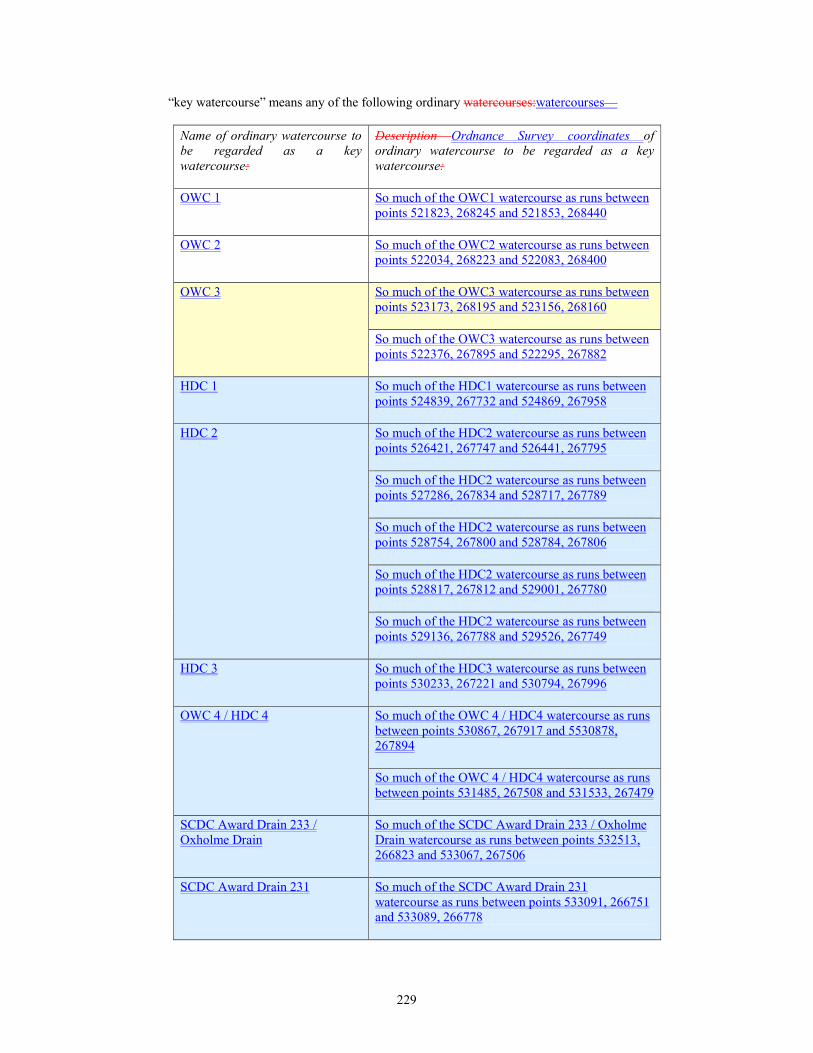
229
“key watercourse” means any of the following ordinary watercourses:watercourses—
Name of ordinary watercourse to
be regarded as a key
watercourse:
Description Ordnance Survey coordinates of
ordinary watercourse to be regarded as a key
watercourse:
OWC 1 So much of the OWC1 watercourse as runs between
points 521823, 268245 and 521853, 268440
OWC 2 So much of the OWC2 watercourse as runs between
points 522034, 268223 and 522083, 268400
OWC 3 So much of the OWC3 watercourse as runs between
points 523173, 268195 and 523156, 268160
So much of the OWC3 watercourse as runs between
points 522376, 267895 and 522295, 267882
HDC 1 So much of the HDC1 watercourse as runs between
points 524839, 267732 and 524869, 267958
HDC 2 So much of the HDC2 watercourse as runs between
points 526421, 267747 and 526441, 267795
So much of the HDC2 watercourse as runs between
points 527286, 267834 and 528717, 267789
So much of the HDC2 watercourse as runs between
points 528754, 267800 and 528784, 267806
So much of the HDC2 watercourse as runs between
points 528817, 267812 and 529001, 267780
So much of the HDC2 watercourse as runs between
points 529136, 267788 and 529526, 267749
HDC 3 So much of the HDC3 watercourse as runs between
points 530233, 267221 and 530794, 267996
OWC 4 / HDC 4 So much of the OWC 4 / HDC4 watercourse as runs
between points 530867, 267917 and 5530878,
267894
So much of the OWC 4 / HDC4 watercourse as runs
between points 531485, 267508 and 531533, 267479
SCDC Award Drain 233 /
Oxholme Drain
So much of the SCDC Award Drain 233 / Oxholme
Drain watercourse as runs between points 532513,
266823 and 533067, 267506
SCDC Award Drain 231 So much of the SCDC Award Drain 231
watercourse as runs between points 533091, 266751
and 533089, 266778

230
Name of ordinary watercourse to
be regarded as a key
watercourse:
Description Ordnance Survey coordinates of
ordinary watercourse to be regarded as a key
watercourse:
So much of the SCDC Award Drain 231
watercourse as runs between points 533090, 266887
and 533439, 267257
OWC 5 The OWC 5 watercourse, running between points
533446, 267249 and 534029, 266876
OWC 6 The OWC 6 watercourse, running between points
534453, 266520 and 535070, 266111
SCDC Award Drain 190 So much of the SCDC Award Drain 190
watercourse as runs between points 534823, 266407
and 534832, 266434
OWC7 The OWC 7 watercourse, running between points
535318, 266022 and 534794, 266356
SCDC Award Drain 193 So much of the SCDC Award Drain 193
watercourse as runs between points 535789, 265742
and 535826, 265780
OWC 8 The OWC 8 watercourse, running between points
535807, 265549 and 537001, 264810
Utton’s Drove Drain / SCDC
Award Drain 194
So much of the Utton’s Drove Drain / SCDC Award
Drain 194 watercourse as runs between points
536441, 265028 and 536709, 265207
SCDC Award Drain 308 So much of the SCDC Award Drain 308
watercourse as runs between points 537364, 264658
and 537361, 264697
OWC 9 The OWC 9 watercourse, running between points
537097, 264733 and 537553, 264417
OWC 10 The OWC 10 watercourse, running between points
537000, 264899 and 538032, 264203
Longstanton Brook / SCDC
Award Drain 188
So much of the Longstanton Brook / SCDC Award
Drain 188 watercourse as runs between points
537955, 264159 and 538212, 264368
OWC 11 / SCDC Award Drain
396
So much of the SCDC Award Drain 271
watercourse as runs between points 538433, 263936
and 538606, 264349
OWC 12 So much of the Oakington Brook / SCDC Award
Drain 188 watercourse as runs between points
538713, 263666 and 538757, 263702

231
Name of ordinary watercourse to
be regarded as a key
watercourse:
Description Ordnance Survey coordinates of
ordinary watercourse to be regarded as a key
watercourse:
SCDC Award Drain 170 So much of the OWC 11 / SCDC Award Drain 396
watercourse as runs between points 539258, 263192
and 539412, 263341
SCDC Award Drain 357 (Beck
Brook)
The OWC 12 watercourse, running between points
540680, 262232 and 539706, 262995
So much of the SCDC Award Drain 170
watercourse as runs between points 539734, 262983
and 539987, 263165
SCDC Award Drain 244 So much of the SCDC Award Drain 357 (Beck
Brook) watercourse as runs between points 540136,
261997 and 540515, 262167
So much of the SCDC Award Drain 357 (Beck
Brook) watercourse as runs between points 540611,
262186 and 540647, 262195
So much of the SCDC Award Drain 244
watercourse as runs between points 540667, 261502
and 540780, 261746
OWC 13 / SCDC Award Drain
358
So much of the SCDC Award Drain 244
watercourse as runs between points 540796, 261835
and 540798, 261846
SCDC Award Drain 245 / (Wash
Pitt Brook)
So much of the SCDC Award Drain 244
watercourse as runs between points 540821, 261989
and 540824, 262007
and in each case includes any land or area which is being used or is expected to be used to
provide temporary or permanent flood storage capacity or relief for the watercourse and any
bank, wall, embankment or other structure, or any appliance constructed or used for land
drainage or flood defence in connection with the watercourse;
“ordinary watercourse” has the same meaning as given in section 72 (Interpretation) of the
Land Drainage Act 1991;
“plans” includes sections, drawings, specifications and method statements; and
“relevant drainage authority” means Cambridgeshire County Council, an internal drainage
board or any other body having functions in respect of a drainage work;
“specified work” means any of the following works carried out in relation to any ordinary
watercourse—
(a) erecting any mill dam, weir or other similar obstruction to the flow of the watercourse, or
raising or otherwise altering any such obstruction;
(b) erecting a culvert in the watercourse; or
(c) altering a culvert in a manner that would be likely to affect the flow of the watercourse.
232
Key watercourses
33.—(1) Before beginning to construct any specified work in relation to a key watercourse, the
undertaker shall submit to the relevant drainage authority plans of the work, and such further
particulars available to the undertaker as that drainage authority may within 28 days of the
submission of the plans reasonably require.
(2) Any such specified work in relation to a key watercourse must not be constructed except in
accordance with such plans as may be approved in writing by the relevant drainage authority, or
determined under paragraph 41.
(3) Any approval of the relevant drainage authority required under this paragraph—
(a) must not be unreasonably withheld or delayed;
(b) is to be deemed to have been given if it is neither given nor refused within 2 months of
the submission of the plans for approval or where further particulars are submitted under
sub-paragraph (1), within 2 months of the submission of those particulars; and
(c) may be given subject to such reasonable requirements or conditions as the drainage
authority may make for the protection of any key watercourse or for the prevention of
flooding.
34. The requirements or conditions which a drainage authority may make under paragraph 33
include conditions requiring the undertaker at its own expense to construct such protective works
(including any new works as well as alterations to existing works) as are reasonably necessary—
(a) to safeguard any key watercourse against damage, or
(b) to secure that the efficiency of any key watercourse for flood defence purposes is not
impaired and that the risk of flooding is not otherwise increased,
by reason of the specified work in relation to a key watercourse.
35.—(1) Any specified work in relation to a key watercourse, and all protective works required
by a drainage authority under paragraph 33, must be constructed to the reasonable satisfaction of
the drainage authority and an officer of the drainage authority is entitled on giving such notice as
may be reasonable in the circumstances, to inspect and watch the construction of such works.
(2) The undertaker must give to the relevant drainage authority not less than 14 days’ notice of
its intention to commence construction of any specified work in relation to a key watercourse and
the undertaker must give to that drainage authority notice of completion of a specified work in
relation to a key watercourse not later than 7 days after the date on which it is brought into use.
(3) If any part of the works comprising a structure in, over or under a key watercourse is
constructed otherwise than in accordance with the requirements of this Part of this Schedule, the
relevant drainage authority may by notice require the undertaker at its own expense to comply
with the requirements of this Part of this Schedule or (if the undertaker so elects and the drainage
authority in writing consents, such consent not to be unreasonably withheld) to remove, alter or
pull down the work and, where removal is required, to restore the site to its former condition to
such extent and within such limits as the drainage authority reasonably requires.
(4) Subject to sub-paragraph (5), if within a reasonable period, being not less than 28 days from
the date when a notice under sub-paragraph (3) is served upon the undertaker, it has failed to begin
taking steps to comply with the requirements of the notice and subsequently to make reasonably
expeditious progress towards their implementation, the relevant drainage authority may execute
the works specified in the notice and any expenditure reasonably incurred by it in so doing is to be
recoverable from the undertaker.
(5) In the event of any dispute as to whether sub-paragraph (3) is properly applicable to any
work in respect of which notice has been served under that sub-paragraph, or as to the
reasonableness of any requirement of such a notice, the drainage authority must not, except in an
emergency, exercise the powers conferred by sub-paragraph (4) until the dispute has been finally
determined.
233
General
36.—(1) From the commencement of the construction of any specified work until the date
falling 12 months from the date of completion of the specified work (“the maintenance period”),
the undertaker must maintain in good repair and condition and free from obstruction the drainage
work which is situated within the limits of deviation for that specified work and on land held by
the undertaker for the purposes or in connection with the specified work, whether the drainage
work is constructed under this Order or is already in existence. Upon the expiry of the
maintenance period, the drainage work must be maintained by the highway authority for the
highway to which the specified work relates.
(2) If any such drainage work is not maintained to the reasonable satisfaction of the relevant
drainage authority, that drainage authority may by notice require the person liable for maintenance
of the drainage work to maintain the drainage work, or any part of it, to such extent as the drainage
authority reasonably requires.
(3) If, within a reasonable period being not less than 28 days beginning with the date on which a
notice in respect of any drainage work is served under sub-paragraph (2) on the person liable for
maintenance, that person has failed to begin taking steps to comply with the reasonable
requirements of the notice and has not subsequently made reasonably expeditious progress
towards their implementation, the drainage authority may do what is necessary for such
compliance and may recover any expenditure reasonably incurred by it in so doing from the
person liable for maintenance.
(4) In the event of any dispute as to the reasonableness of any requirement of a notice served
under sub-paragraph (2), the relevant drainage authority must not except in a case of emergency
exercise the powers of sub-paragraph (3) until the dispute has been finally determined.
37. If by reason of the construction of any specified work or of the failure of any such work the
efficiency of any ordinary watercourse for flood defence purposes is impaired, or that watercourse
is otherwise damaged, so as to require remedial action, such impairment or damage must be made
good by the undertaker to the reasonable satisfaction of the relevant drainage authority and if the
undertaker fails to do so, that drainage authority may make good the same and recover from the
undertaker the expense reasonably incurred by it in doing so.
38.—(1) The undertaker must indemnify a relevant drainage authority in respect of all costs,
charges and expenses which it may reasonably incur or which it may sustain—
(a) in the examination or approval of plans under this Part of this Schedule; and
(b) in the inspection of the construction of a specified work in respect of a key watercourse or
any protective works required by a relevant drainage authority under this Part of this
Schedule.
(2) The maximum amount payable to a relevant drainage authority under sub-paragraph (1)(a) or
(b) shall be the same as would have been payable to the relevant drainage authority in accordance
with the scale of charges for pre-application advice and land drainage consent applications
published on the relevant drainage authority’s website from time to time.
39.—(1) Without prejudice to the other provisions of this Part of this Schedule, the undertaker
must indemnify a relevant drainage authority from all claims, demands, proceedings or damages,
which may be made or taken against, or recovered from a relevant drainage authority by reason
of—
(a) any damage to any ordinary watercourse so as to impair its efficiency for flood defence
purposes,
(b) any raising or lowering of the water table in land adjoining the works authorised by this
Order or adjoining any sewers, drains and watercourses, or
(c) any flooding or increased flooding of any such lands,
which is caused by, or results from, the construction of any specified work or any act or omission
of the undertaker, its contractors, agents or employees whilst engaged upon the work.

234
(2) A relevant drainage authority must give to the undertaker reasonable notice of any such
claim or demand and no settlement or compromise of any such claim or demand is to be made
without the consent of the undertaker which, if it withholds such consent, is to have the sole
conduct of any settlement or compromise or of any proceedings necessary to resist the claim or
demand.
40. The fact that any work or thing has been executed or done in accordance with a plan
approved or deemed to have been approved by a relevant drainage authority, or to its satisfaction,
does not (in the absence of negligence on the part of a relevant drainage authority, its officers,
contractors or agents) relieve the undertaker from any liability under the provisions of this Part of
this Schedule.
41. Any dispute arising between the undertaker and a relevant drainage authority under this Part
of this Schedule is to be determined by arbitration.
PART 5
FOR THE PROTECTION OF NATIONAL GRID
Application
42. For the protection of National Grid as referred to in this Schedule the following provisions
shall, unless otherwise agreed in writing between the undertaker and National Grid, have effect.
Interpretation
43. In this Schedule—
“alternative apparatus” means appropriate alternative apparatus to the satisfaction of National
Grid to enable National Grid to fulfil its statutory functions in a manner no less efficient than
previously;
“apparatus” means mains, pipes or other apparatus belonging to or maintained by National
Grid for the purposes of gas supply;
“authorised development” has the same meaning as in article 2 of this Order and (unless
otherwise specified) for the purposes of this Schedule shall include the use and maintenance of
the authorised development;
“commence” has the same meaning as in article 2 of this Order and commencement shall be
construed to have the same meaning;
“functions” includes powers and duties;
“in” in a context referring to apparatus or alternative apparatus in land includes a reference to
apparatus or alternative apparatus under, over, across, along or upon such land;
“maintain” and “maintenance” shall include the ability and right to do any of the following in
relation to any apparatus or alternative apparatus of National Grid including construct, use,
repair, alter, inspect, renew or remove the apparatus;
“National Grid” means National Grid Gas PLC (Company No. 200600) whose registered
office is at 1-3 Strand, London, WC2N 5EH;
“plan” or “plans” include all designs, drawings, specifications, method statements, soil
reports, programmes, calculations, risk assessments and other documents that are reasonably
necessary properly and sufficiently to describe and assess the works to be executed; and
“specified work” means so much of any of the authorised development that will or may be
situated 15m (measured in any direction) of, or which may affect, any apparatus.
44. this This Schedule does not apply to apparatus in respect of which the relations between the
undertaker and National Grid are regulated by the provisions of Part 3 of the 1991 Act.
235
Apparatus of National Grid in streets subject to temporary stopping up or restriction
45. Notwithstanding the temporary prohibition or restriction under the powers of article 14
(temporary stopping up and restriction of use of streets), National Grid shall be at liberty at all
times to take all necessary access across any such street and/or to execute and do all such works
and things in, upon or under any such street as may be reasonably necessary or desirable to enable
it to maintain any apparatus which at the time of the prohibition or restriction was in that street.
Acquisition of land
46.—(1) Regardless of any provision in this Order or anything shown on the land plans or
contained in the book of reference to the Order the undertaker must not acquire any land interest
or apparatus or override any easement or other interest of National Grid otherwise than by
agreement (such agreement not to be unreasonably withheld).
(2) The undertaker and National Grid agree that where there is any inconsistency or duplication
between the provisions set out in this Schedule relating to the relocation and/or removal of
apparatus/including but not limited to the payment of costs and expenses relating to such
relocation and/or removal of apparatus) and the provisions of any existing easement, rights,
agreements and licences granted, used, enjoyed or exercised by National Grid as of right or other
use in relation to the apparatus then the provisions in this Schedule shall prevail.
Removal of apparatus
47.—(1) If, in the exercise of the agreement reached in accordance with paragraph 5 46 or in
any other authorised manner, the undertaker acquires any interest in any land in which any
apparatus is placed, that apparatus must not be removed under this Schedule and any right of
National Grid to maintain that apparatus in that land shall not be extinguished until alternative
apparatus has been constructed, and is in operation to the reasonable satisfaction of National Grid
in accordance with sub-paragraphs (2) to (5) inclusive.
(2) If, for the purpose of executing any works comprised in the authorised development in, on,
under or over any land purchased, held, appropriated or used under this Order, the undertaker
requires the removal of any apparatus placed in that land, it must give to National Grid 56 days’
advance written notice of that requirement, together with a plan of the work proposed, and of the
proposed position of the alternative apparatus to be provided or constructed and in that case (or if
in consequence of the exercise of any of the powers conferred by this Order National Grid
reasonably needs to remove any of its apparatus) the undertaker shall, subject to sub-
paragraph (3), afford to National Grid to their satisfaction (taking into account paragraph 48 sub-
paragraph (1) below) the necessary facilities and rights for—
(a) the construction of alternative apparatus in other land of the undertaker; and
(b) subsequently for the maintenance of that apparatus.
(3) If alternative apparatus or any part of such apparatus is to be constructed elsewhere than in
other land of the undertaker, or the undertaker is unable to afford such facilities and rights as are
mentioned in sub-paragraph (2), in the land in which the alternative apparatus or part of such
apparatus is to be constructed, National Grid must, on receipt of a written notice to that effect from
the undertaker, take such steps as are reasonable in the circumstances in an endeavour to obtain
the necessary facilities and rights in the land in which the alternative apparatus is to be constructed
save that this obligation shall not extend to the requirement for National Grid to use its
compulsory purchase powers to this end unless it elects to so do.
(4) Any alternative apparatus to be constructed in land of the undertaker under this Schedule
shall be constructed in such manner and in such line or situation as may be agreed between
National Grid and the undertaker.
(5) National Grid must, after the alternative apparatus to be provided or constructed has been
agreed, and subject to the grant to National Grid of any such facilities and rights as are referred to
in sub-paragraph (2) or (3), proceed without unnecessary delay to construct and bring into
236
operation the alternative apparatus and subsequently to remove any apparatus required by the
undertaker to be removed under the provisions of this Schedule.
Facilities and rights for alternative apparatus
48.—(1) Where, in accordance with the provisions of this Schedule, the undertaker affords to
National Grid facilities and rights for the construction and maintenance in land of the undertaker
of alternative apparatus in substitution for apparatus to be removed, those facilities and rights shall
be granted upon such terms and conditions as may be agreed between the undertaker and National
Grid and must be no less favourable on the whole to National Grid than the facilities and rights
enjoyed by it in respect of the apparatus to be removed unless agreed by National Grid.
(2) If the facilities and rights to be afforded by the undertaker and agreed with National Grid
under paragraph 48 sub-paragraph (1) above in respect of any alternative apparatus, and the terms
and conditions subject to which those facilities and rights are to be granted, are less favourable on
the whole to National Grid than the facilities and rights enjoyed by it in respect of the apparatus to
be removed and the terms and conditions to which those facilities and rights are subject in the
matter shall be referred to arbitration and, the arbitrator shall make such provision for the payment
of compensation by the undertaker to National Grid as appears to the arbitrator to be reasonable
having regard to all the circumstances of the particular case. In respect of the appointment of an
arbitrator under this sub-paragraph (2), article 43 of the Order shall apply.
Retained apparatus: protection of National Grid as Gas Undertaker
49.—(1) Not less than 56 days before the commencement of any authorised development
authorised by this Order that involves activities or works specified in National Grid’s
“Specification for safe working in the vicinity of National Grid, High pressure Gas pipelines and
associated installation requirements for third parties T/SP/SSW22” that are within the proximities
described therein to any apparatus the removal of which has not been required by the undertaker
under paragraph 6 sub paragraph (247(2) or otherwise, the undertaker must submit to National
Grid a plan.
(2) In relation to specified works, or any works that (wherever situated) impose any load directly
upon any apparatus, the plan to be submitted to National Grid under sub-paragraph (1) shall
show—
(a) the exact position of the works;
(b) the level at which these are proposed to be constructed or renewed;
(c) the manner of their construction or renewal including details of excavation, positioning of
plant etc.;
(d) the position of all apparatus;
(e) by way of detailed drawings, every alteration proposed to be made to or close to any such
apparatus;
(f) intended maintenance regimes; and
(g) details of any ground monitoring scheme (if required in accordance with National Grid’s
“Specification for safe working in the vicinity of National Grid, High pressure Gas
pipelines and associated installation requirements for third parties T/SP/SSW22”).
(3) The undertaker must not commence any works to which sub-paragraph (2) applies until
National Grid has given written approval of the plan so submitted.
(4) Any approval of National Grid required under sub-paragraph (3)—
(a) may be given subject to reasonable conditions for any purpose mentioned in sub-
paragraph (5) or (7);
(b) must not be unreasonably withheld.
(5) In relation to a work to which sub-paragraphs (1) and (2) applies, National Grid may require
such modifications to be made to the plans as may be reasonably necessary for the purpose of

237
securing its system against interference or risk of damage or for the purpose of providing or
securing proper and convenient means of access to any apparatus.
(6) Works executed under sub-paragraphs (1) or (2) shall be executed only in accordance with
the plan, submitted under sub-paragraph (1) or as relevant sub paragraph (2), as amended from
time to time by agreement between the undertaker and National Grid and in accordance with such
reasonable requirements as may be made in accordance with sub-paragraphs (4), (5), (7) and/or (8)
by National Grid for the alteration or otherwise for the protection of the apparatus, or for securing
access to it, and National Grid shall be entitled to watch and inspect the execution of those works.
(7) Where National Grid requires protective works to be carried out either themselves or by the
undertaker (whether of a temporary or permanent nature) such protective works shall be carried
out to National Grid’s satisfaction prior to the commencement of any authorised development (or
any relevant part thereof) and National Grid must give 56 days’ notice of such works from the date
of submission of a plan in line with sub-paragraph (1) or (2) (except in an emergency).
(8) If National Grid in accordance with sub-paragraph (5) or (7) and in consequence of the
works proposed by the undertaker, reasonably requires the removal of any apparatus and gives
written notice to the undertaker of that requirement, paragraphs 1 to 3 42 to 44 and 6 to 7 47 to 48
shall apply as if the removal of the apparatus had been required by the undertaker under paragraph
6 sub-paragraph (247(2).
(9) Nothing in this paragraph shall preclude the undertaker from submitting at any time or from
time to time, but in no case less that 56 days before commencing the execution of any works, a
new plan, instead of the plan previously submitted, and having done so the provisions of this
paragraph shall apply to and in respect of the new plan.
(10) The undertaker shall not be required to comply with sub-paragraph (1) where it needs to
carry out emergency works as defined in the 1991 Act but in that case it must give to National
Grid notice as soon as is reasonably practicable and a plan of those works and shall—
(a) comply with sub-paragraph (5), (6) and (7) insofar as is reasonably practicable in the
circumstances; and
(b) comply with sub-paragraph (11) at all times.
(11) At all times when carrying out any works authorised under the Order comply with National
Grid’s policies for safe working in proximity to gas apparatus “Specification for safe working in
the vicinity of National Grid, High pressure Gas pipelines and associated installation requirements
for third parties T/SP/SSW22” and the Health and Safety Executive’s “HS(~G)47 Avoiding
Danger from underground services”.
Expenses
50.—(1) Subject to the following provisions of this paragraph, the undertaker shall pay to
National Grid on demand all charges, costs and expenses reasonably anticipated or incurred by
National Grid in, or in connection with, the inspection, removal, relaying or replacing, alteration
or protection of any apparatus or the construction of any new apparatus which may be required in
consequence of the execution of any such works as are referred to in this Schedule including
without limitation—
(a) any costs reasonably incurred or compensation properly paid in connection with the
acquisition of rights or the exercise of statutory powers for such apparatus including
without limitation in the event that National Grid elects to use compulsory purchase
powers to acquire any necessary rights under paragraph 47 sub-paragraph (3) all costs
incurred as a result of such action;
(b) in connection with the cost of the carrying out of any diversion work or the provision of
any alternative apparatus;
(c) the cutting off of any apparatus from any other apparatus or the making safe of redundant
apparatus;
(d) the approval of plans;
238
(e) the carrying out of protective works, plus a capitalised sum to cover the cost of
maintaining and renewing permanent protective works;
(f) the survey of any land, apparatus or works, the inspection and monitoring of works or the
installation or removal of any temporary works reasonably necessary in consequence of
the execution of any such works referred to in this Schedule.
(2) There must be deducted from any sum payable under sub-paragraph (1) the value of any
apparatus removed under the provisions of this Schedule and which is not re-used as part of the
alternative apparatus, that value being calculated after removal.
(3) If in accordance with the provisions of this Schedule—
(a) apparatus of better type, of greater capacity or of greater dimensions is placed in
substitution for existing apparatus of worse type, of smaller capacity or of smaller
dimensions; or
(b) apparatus (whether existing apparatus or apparatus substituted for existing apparatus) is
placed at a depth greater than the depth at which the existing apparatus was situated,
and the placing of apparatus of that type or capacity or of those dimensions or the placing of
apparatus at that depth, as the case may be, is not agreed by the undertaker or in default of
agreement settled by arbitration in accordance with article 43 (arbitration) of the Order to be
necessary, then, if such placing involves cost in the construction of works under this Schedule
exceeding that which would have been involved if the apparatus placed had been of the existing
type, capacity or dimensions, or at the existing depth, as the case may be, the amount which apart
from this sub-paragraph would be payable to National Grid by virtue of sub-paragraph (1) shall be
reduced by the amount of that excess save where it is not possible in the circumstances to obtain
the existing type of operations, capacity, dimensions or place at the existing depth in which case
full costs shall be borne by the undertaker.
(4) For the purposes of sub-paragraph (3)—
(a) an extension of apparatus to a length greater than the length of existing apparatus shall
not be treated as a placing of apparatus of greater dimensions than those of the existing
apparatus; and
(b) where the provision of a joint in a pipe or cable is agreed, or is determined to be
necessary, the consequential provision of a jointing chamber or of a manhole shall be
treated as if it also had been agreed or had been so determined.
(5) An amount which apart from this sub-paragraph would be payable to National Grid in
respect of works by virtue of sub-paragraph (1) shall, if the works include the placing of apparatus
provided in substitution for apparatus placed more than 7 years and 6 months earlier so as to
confer on National Grid any financial benefit by deferment of the time for renewal of the
apparatus in the ordinary course, be reduced by the amount which represents that benefit.
Indemnity
51.—(1) Subject to sub-paragraphs (2) and (3), if by reason or in consequence of the
construction of any works authorised by this Schedule or in consequence of the construction, use,
maintenance or failure of any of the authorised development by or on behalf of the undertaker or
in consequence of any act or default of the undertaker (or any person employed or authorised by
him) in the course of carrying out such works (including without limitation works carried out by
the undertaker under this Schedule or any subsidence resulting from any of these works), any
material damage is caused to any apparatus or alternative apparatus (other than apparatus the
repair of which is not reasonably necessary in view of its intended removal for the purposes of
those works) or property of National Grid , or there is any interruption in any service provided, or
in the supply of any goods, by National Grid , or National Grid becomes liable to pay any amount
to any third party, the undertaker shall—
(a) bear and pay on demand the cost reasonably incurred by National Grid in making good
such damage or restoring the supply; and
239
(b) indemnify National Grid for any other expenses, loss, demands, proceedings, damages,
claims, penalty or costs incurred by or recovered from National Grid, by reason or in
consequence of any such damage or interruption or National Grid becoming liable to any
third party as aforesaid.
(2) The fact that any act or thing may have been done by National Grid on behalf of the
undertaker or in accordance with a plan approved by National Grid or in accordance with any
requirement of National Grid as a consequence of the authorised development or under its
supervision shall not (unless sub-paragraph (3) applies) excuse the undertaker from liability under
the provisions of sub-paragraph (1) unless National Grid fails to carry out and execute the works
properly with due care and attention and in a skilful and workman like manner or in a manner that
does not materially accord with the approved plan or as otherwise agreed between the undertaker
and National Grid.
(3) Nothing in sub-paragraph (1) shall impose any liability on the undertaker in respect of any
damage or interruption to the extent that it is attributable to the neglect or default of National Grid,
its officers, servants, contractors or agents.; and
(4) any authorised development and/or any other works authorised by this Schedule carried
out by National Grid as an assignee, transferee or lessee of the undertaker with the benefit of the
Order pursuant to section 156 of the 2008 Act or under Article 9 of the Order subject to the
proviso that once such works become apparatus (“new apparatus”), any works yet to be executed
and not falling within this sub-section 3(b) shall be subject to the full terms of this Schedule
including this paragraph 11 in respect of such new apparatus.
(4) (5)National Grid must give the undertaker reasonable notice of any such claim or demand
and no settlement or compromise shall be made without first consulting the undertaker and
considering their representations.
(5) (6)National Grid must use its reasonable endeavours to mitigate in whole or in part and to
minimise any costs, expenses, loss, demands, and penalties to which the indemnity under this
paragraph 11 51 applies. If reasonably requested to do so by the undertaker, National Grid shall
provide an explanation of how the claim has been minimised. The undertaker shall only be liable
under this paragraph 11 51 for costs and expenses properly incurred by National Grid.
Co-operation
52. National Grid and the undertaker must each use their best endeavours to co-ordinate with the
other party on the timing and method of execution of any works carried out under the Order or this
Schedule in the interests of safety and the efficient and economic execution of the authorised
development and taking into account the need to ensure the safe and efficient operation of the
other party’s operations.
Access
53. If in consequence of the agreement reached in accordance with paragraph 46(1) or the
powers granted under this Order the access to any apparatus is materially obstructed, the
undertaker shall provide such alternative means of access to such apparatus as will enable
National Grid to maintain or use the apparatus no less effectively than was possible before such
obstruction.
Arbitration
54. Any difference or dispute arising between the undertaker and National Grid under this
Schedule shall, unless otherwise agreed in writing between the undertaker and National Grid, be
determined by arbitration in accordance with article 43 (arbitration) of the Order.

240
PART 6
FOR THE PROTECTION OF RAILWAY INTERESTS
55. The following provisions of this Schedule have effect, unless otherwise agreed in writing
between the undertaker and Network Rail and, in the case of paragraph 6968, any other person on
whom rights or obligations are conferred by that paragraph.
56. In this Schedule—
“construction” includes execution, placing, alteration and reconstruction and “construct” and
“constructed” have corresponding meanings;
“the engineer” means an engineer appointed by Network Rail for the purposes of this Order;
“network licence” means the network licence, as the same is amended from time to time,
granted to Network Rail Infrastructure Limited by the Secretary of State in exercise of his
powers under section 8 of the Railways Act 1993(a);
“Network Rail” means Network Rail Infrastructure Limited and any associated company of
Network Rail Infrastructure Limited which holds property for railway purposes, and for the
purpose of this definition “associated company” means any company which is (within the
meaning of section 1159 of the Companies Act 2006(b) the holding company of Network Rail
Infrastructure Limited, a subsidiary of Network Rail Infrastructure Limited or another
subsidiary of the holding company of Network Rail Infrastructure Limited;
“plans” includes sections, designs, design data, software, drawings, specifications, soil reports,
calculations, descriptions (including descriptions of methods of construction), staging
proposals, programmes and details of the extent, timing and duration of any proposed
occupation of railway property;
“protective works” means any works specified by the engineer under paragraph 60(459(4);
“railway operational procedures” means procedures specified under any access agreement (as
defined in the Railways Act 1993) or station lease;
“railway property” means any railway belonging to Network Rail and—
(a) any station, land, works, apparatus and equipment belonging to Network Rail or
connected with any such railway; and
(b) any easement or other property interest held or used by Network Rail for or connected
with the purposes of such railway or works, apparatus or equipment; and
“specified work” means so much of any of the authorised development as is or is to be situated
upon, across, under, over or within 15 metres of, or may in any way adversely affect, railway
property.
57.—(1) Where under this Schedule Network Rail is required to give its consent or approval in
respect of any matter, that consent or approval is subject to the condition that Network Rail
complies with any relevant railway operational procedures and any obligations under its network
licence or under statute.
(2) In so far as any specified work or the acquisition or use of railway property or rights over
railway property is or may be subject to railway operational procedures, Network Rail must—
(a) co-operate with the undertaker with a view to avoiding undue delay and securing
conformity as between any plans approved by the engineer and requirements emanating
from those procedures; and
(b) use its reasonable endeavours to avoid any conflict arising between the application of
those procedures and the proper implementation of the authorised development pursuant
to this Order.
(a) 1993 c.43 (b) 2006 c.46
241
58.—(1) The undertaker must not exercise the powers conferred by articles 13 (Permanent
permanent stopping up of streets and private means of access), 14 (Temporary temporary stopping
up and restriction of use of streets), 15 (Access access to works), 17 (Discharge discharge of
water), 18 (Protective protective works to buildings), 19 (Authority authority to survey and
investigate land), 20 (Compulsory compulsory acquisition of land), 23 (Compulsory compulsory
acquisition of rights), 24 (Public public rights of way), 25 (Private private rights over land), 27
(Acquisition acquisition of subsoil or airspace only), 28 (Acquisition acquisition of part of certain
properties), 29 (Rights rights under or over streets), 30 (Temporary temporary use of land for
carrying out the authorised development), 31 (Temporary temporary use of land for maintaining
the authorised development), 32 (Statutory statutory undertakers), 36 (Felling felling or lopping of
trees and removal of hedgerows) and 37 (Trees trees subject to tree preservation orders) or the
powers conferred by section 11(3) of the 1965 Act (powers of entry) or the 1981 Act as applied by
this Order in respect of any railway property unless the exercise of such powers is with the consent
of Network Rail.
(2) The undertaker must not in the exercise of the powers conferred by this Order prevent
pedestrian or vehicular access to any railway property, unless preventing such access is with the
consent of Network Rail.
(3) The undertaker must not exercise the powers conferred by sections 271 or 272 of the 1990
Act or article 32 (Statutory statutory undertakers), in relation to any right of access of Network
Rail to railway property, but such right of access may be diverted with the consent of Network
Rail.
(4) The undertaker must not under the powers of this Order acquire or use or acquire new rights
over any railway property except with the consent of Network Rail.
(5) Where Network Rail is asked to give its consent pursuant to this paragraph, such consent
must not be unreasonably withheld but may be given subject to reasonable conditions.
59.—(1) The undertaker must before commencing construction of any specified work supply to
Network Rail proper and sufficient plans of that work for the reasonable approval of the engineer
and the specified work must not be commenced except in accordance with such plans as have been
approved in writing by the engineer or settled by arbitration.
(2) The approval of the engineer under sub-paragraph (1) must not be unreasonably withheld,
and if by the end of the period of 28 days beginning with the date on which such plans have been
supplied to Network Rail the engineer has not intimated his disapproval of those plans and the
grounds of his disapproval the undertaker may serve upon the engineer written notice requiring the
engineer to intimate his approval or disapproval within a further period of 28 days beginning with
the date upon which the engineer receives written notice from the undertaker. If by the expiry of
the further 28 days the engineer has not intimated his approval or disapproval, the engineer be
deemed to have approved the plans as submitted.
(3) If by the end of the period of 28 days beginning with the date on which written notice was
served upon the engineer under sub-paragraph (2), Network Rail gives notice to the undertaker
that Network Rail desires itself to construct any part of a specified work which in the opinion of
the engineer will or may affect the stability of railway property or the safe operation of traffic on
the railways of Network Rail then, if the undertaker desires such part of the specified work to be
constructed, Network Rail must construct it with all reasonable dispatch on behalf of and to the
reasonable satisfaction of the undertaker in accordance with the plans approved or deemed to be
approved or settled under this paragraph, and under the supervision (where appropriate and if
given) of the undertaker.
(4) When signifying his approval of the plans the engineer may specify any protective works
(whether temporary or permanent) which in the engineer’s opinion should be carried out before
the commencement of the construction of a specified work to ensure the safety or stability of
railway property or the continuation of safe and efficient operation of the railways of Network
Rail or the services of operators using the same (including any relocation de-commissioning and
removal of works, apparatus and equipment necessitated by a specified work and the comfort and
safety of passengers who may be affected by the specified works), and such protective works as
may be reasonably necessary for those purposes must be constructed by Network Rail or by the
242
undertaker, if Network Rail so desires, and such protective works must be carried out at the
expense of the undertaker in either case with all reasonable dispatch and the undertaker must not
commence the construction of the specified works until the engineer has notified the undertaker
that the protective works have been completed to his reasonable satisfaction.
60.—(1) Any specified work and any protective works to be constructed by virtue of paragraph
5(459(4) must, when commenced, be constructed—
(a) with all reasonable dispatch in accordance with the plans approved or deemed to have
been approved or settled under paragraph 6059;
(b) under the supervision (where appropriate and if given) and to the reasonable satisfaction
of the engineer;
(c) in such manner as to cause as little damage as is possible to railway property; and
(d) so far as is reasonably practicable, so as not to interfere with or obstruct the free,
uninterrupted and safe use of any railway of Network Rail or the traffic on it and the use
by passengers of railway property.
(2) If any damage to railway property or any such interference or obstruction is caused by the
carrying out of, or in consequence of the construction of a specified work or a protective work, the
undertaker must, regardless of any such approval, make good such damage and must pay to
Network Rail all reasonable expenses to which Network Rail may be put and compensation for
any loss which it may sustain by reason of any such damage, interference or obstruction.
(3) Nothing in this Schedule imposes any liability on the undertaker with respect to any damage,
costs, expenses or loss attributable to the negligence of Network Rail or its servants, contractors or
agents or any liability on Network Rail with respect of any damage, costs, expenses or loss
attributable to the negligence of the undertaker or its servants, contractors or agents.
61. The undertaker must-must—
(a) at all times afford reasonable facilities to the engineer for access to a specified work or a
protective work during its construction; and
(b) supply the engineer with all such information as the engineer may reasonably require with
regard to a specified work or a protective work or the method of constructing it.
62. Network Rail must at all times afford reasonable facilities to the undertaker and its agents
for access to any works carried out by Network Rail under this Schedule during their construction
and must supply the undertaker with such information as it may reasonably require with regard to
such works or the method of constructing them.
63.—(1) If any permanent or temporary alterations or additions to railway property, are
reasonably necessary in consequence of the construction of a specified work or a protective work,
or during a period of 24 months after the completion of that work in order to ensure the safety of
railway property or the continued safe operation of the railway of Network Rail, such alterations
and additions may be carried out by Network Rail and if Network Rail gives to the undertaker
reasonable notice of its intention to carry out such alterations or additions (which must be
specified in the notice), the undertaker must pay to Network Rail the reasonable cost of those
alterations or additions including, in respect of any such alterations and additions as are to be
permanent, a capitalised sum representing the increase of the costs which may be expected to be
reasonably incurred by Network Rail in maintaining, working and, when necessary, renewing any
such alterations or additions.
(2) If during the construction of a specified work or a protective work by the undertaker,
Network Rail gives notice to the undertaker that Network Rail desires itself to construct that part
of the specified work or the protective work which in the opinion of the engineer is endangering
the stability of railway property or the safe operation of traffic on the railways of Network Rail
then, if the undertaker decides that part of the specified work or the protective work is to be
constructed, Network Rail must assume construction of that part of the specified work or the
protective work and the undertaker must, regardless of any such approval of a specified work or a
protective work under paragraph 60(3)59, pay to Network Rail all reasonable expenses to which
243
Network Rail may be put and compensation for any loss which it may suffer by reason of the
execution by Network Rail of that specified work or protective work.
(3) The engineer must, in respect of the capitalised sums referred to in this paragraph and
paragraph 65(a64(a) provide such details of the formula by which those sums have been calculated
as the undertaker may reasonably require.
(4) If the cost of maintaining, working or renewing railway property is reduced in consequence
of any such alterations or additions a capitalised sum representing such saving must be set off
against any sum payable by the undertaker to Network Rail under this paragraph.
64. The undertaker must repay to Network Rail all reasonable fees, costs, charges and expenses
reasonably incurred by Network Rail—
(a) in constructing any part of a specified work on behalf of the undertaker as provided by
paragraph 60(359(3) or in constructing any protective works under the provisions of
paragraph 60(459(4) including, in respect of any permanent protective works, a
capitalised sum representing the cost of maintaining and renewing those works;
(b) in respect of the approval by the engineer of plans submitted by the undertaker and the
supervision by the engineer of the construction of a specified work or a protective work;
(c) in respect of the employment or procurement of the services of any inspectors, signallers,
watchkeepers and other persons whom it is reasonably necessary to appoint for
inspecting, signalling, watching and lighting railway property and for preventing, so far
as may be reasonably practicable, interference, obstruction, danger or accident arising
from the construction or failure of a specified work or a protective work;
(d) in respect of any special traffic working resulting from any speed restrictions which may
in the opinion of the engineer, require to be imposed by reason or in consequence of the
construction or failure of a specified work or a protective work or from the substitution of
diversion of services which may be reasonably necessary for the same reason; and
(e) in respect of any additional temporary lighting of railway property in the vicinity of the
specified works, being lighting made reasonably necessary by reason or in consequence
of the construction or failure of a specified work or a protective work.
65.—(1) In this paragraph-paragraph—
“EMI” means, subject to sub-paragraph (2), electromagnetic interference with Network Rail
apparatus generated by the operation of the authorised development (including the operation
of tramcars using the tramway comprised in the works) where such interference is of a level
which adversely affects the safe operation of Network Rail’s apparatus; and
“Network Rail’s apparatus” means any lines, circuits, wires, apparatus or equipment (whether
or not modified or installed as part of the authorised development) which are owned or used
by Network Rail for the purpose of transmitting or receiving electrical energy or of radio,
terlegraphictelegraphic, telephonic, electric, electronic or other like means of signaling
signalling or other communications.
(2) This paragraph applies to EMI only to the extent that such EMI is not attributable to any
change to Network Rail’s apparatus carried out after approval of plans under paragraph 5(159(1)
for the relevant part of the authorised development giving rise to EMI (unless the undertaker has
been given notice in writing before the approval of those plans of the intention to make such
change).
(3) Subject to sub-paragraph (5), the undertaker must in the design and construction of the
authorised development take all measures necessary to prevent EMI and must establish with
Network Rail (both parties acting reasonably) appropriate arrangements to verify their
effectiveness.
(4) In order to facilitate the undertaker’s compliance with sub-paragraph (3)—
(a) the undertaker must consult with Network Rail as early as reasonably practicable to
identify all Network Rail’s apparatus which may be at risk of EMI, and thereafter must
continue to consult with Network Rail (both before and after formal submission of plans
244
under paragraph 60(159(1)) in order to identify all potential causes of EMI and the
measures required to eliminate them;
(b) Network Rail must make available to the undertaker all information in the possession of
Network Rail reasonably requested by the undertaker in respect of Network Rail’s
apparatus identified pursuant to sub-paragraph (a); and
(c) Network Rail must allow the undertaker reasonable facilities for the inspection of
Network Rail’s apparatus identified pursuant to sub-paragraph (a).
(5) In any case where it is established that EMI can only reasonably be prevented by
modifications to Network Rail’s apparatus, Network Rail must not withhold its consent
unreasonably to modifications of Network Rail’s apparatus, but the means of prevention and the
method of their execution must be selected in the reasonable discretion of Network Rail, and in
relation to such modifications paragraph 60(159(1) have effect subject to this sub-paragraph.
(6) If at any time prior to the completion of the authorised development and regardless of any
measures adopted pursuant to sub-paragraph (3), the testing or commissioning of the authorised
development causes EMI then the undertaker must immediately upon receipt of notification by
Network Rail of such EMI either in writing or communicated orally (such oral communication to
be confirmed in writing as soon as reasonably practicable after it has been issued) cease to use (or
procure the cessation of use of) the undertaker’s apparatus causing such EMI until all measures
necessary have been taken to remedy such EMI by way of modification to the source of such EMI
or (in the circumstances, and subject to the consent, specified in sub-paragraph (5)) to Network
Rail’s apparatus.
(7) In the event of EMI having occurred –occurred—
(a) the undertaker must afford reasonable facilities to Network Rail for access to the
undertaker’s apparatus in the investigation of such EMI;
(b) Network Rail must afford reasonable facilities to the undertaker for access to Network
Rail’s apparatus in the investigation of such EMI; and
(c) Network Rail must make available to the undertaker any additional material information
in its possession reasonably requested by the undertaker in respect of Network Rail’s
apparatus or such EMI.
(8) Where Network Rail approves modifications to Network Rail’s apparatus pursuant to sub-
paragraphs (5) or (6) –6)—
(a) Network Rail must allow the undertaker reasonable facilities for the inspection of the
relevant part of Network Rail’s apparatus; and
(b) any modifications to Network Rail’s apparatus approved pursuant to those sub-
paragraphs must be carried out and completed by the undertaker in accordance with
paragraph 61.
(9) To the extent that it would not otherwise do so, the indemnity in paragraph 69(168(1) applies
to the costs and expenses reasonably incurred or losses suffered by Network Rail through the
implementation of the provisions of this paragraph (including costs incurred in connection with
the consideration of proposals, approval of plans, supervision and inspection of works and
facilitating access to Network Rail’s apparatus) or in consequence of any EMI to which sub-
paragraph (6) applies.
(10) For the purpose of paragraph 65(a64(a) any modifications to Network Rail’s apparatus
under this paragraph are deemed to be protective works referred to in that paragraph.
(11) In relation to any dispute arising under this paragraph the reference in article 43
(Arbitrationarbitration) to the Institution of Civil Engineers is to be read as a reference to the
Institution of Engineering and Technology.
(12) If at any time after the completion of a specified work or a protective work, not being a
work vested in Network Rail, Network Rail gives notice to the undertaker informing it that the
state of maintenance of any part of the specified work or the protective work appears to be such as
adversely affects the operation of railway property, the undertaker must, on receipt of such notice,
245
take such steps as may be reasonably necessary to put that specified work or that protective work
in such state of maintenance as not adversely to affect railway property.
66. The undertaker must not provide any illumination or illuminated sign or signal on or in
connection with a specified work or a protective work in the vicinity of any railway belonging to
Network Rail unless it has first consulted Network Rail and it must comply with Network Rail’s
reasonable requirements for preventing confusion between such illumination or illuminated sign or
signal and any railway signal or other light used for controlling, directing or securing the safety of
traffic on the railway.
67. Any additional expenses which Network Rail may reasonably incur in altering,
reconstructing or maintaining railway property under any powers existing at the making of this
Order by reason of the existence of a specified work or a protective work must, provided that 56
days’ previous notice of the commencement of such alteration, reconstruction or maintenance has
been given to the undertaker, be repaid by the undertaker to Network Rail.
68.—(1) The undertaker must pay to Network Rail all reasonable costs, charges, damages and
expenses not otherwise provided for in this Schedule which may be occasioned to or reasonably
incurred by Network Rail—
(a) by reason of the construction or maintenance of a specified work or a protective work or
the failure thereof ; or
(b) by reason of any act or omission of the undertaker or of any person in its employ or of its
contractors or others whilst engaged upon a specified work or a protective work;,
and the undertaker must indemnify and keep indemnified Network Rail from and against all
claims and demands arising out of or in connection with a specified work or a protective work or
any such failure, act or omission: and the fact that any act or thing may have been done by
Network Rail on behalf of the undertaker or in accordance with plans approved by the engineer or
in accordance with any requirement of the engineer or under his supervision will not (if it was
done without negligence on the part of Network Rail or of any person in its employ or of its
contractors or agents) excuse the undertaker from any liability under the provisions of this sub-
paragraph.
(2) Network Rail must give the undertaker reasonable notice of any such claim or demand and
no settlement or compromise of such a claim or demand is to be made without the prior consent of
the undertaker.
(3) The sums payable by the undertaker under sub-paragraph (1) may include a sum equivalent
to the relevant costs.
(4) Subject to the terms of any agreement between Network Rail and a train operator regarding
the timing or method of payment of the relevant costs in respect of that train operator, Network
Rail must promptly pay to each train operator the amount of any sums which Network Rail
receives under sub-paragraph (3) which relates to the relevant costs of that train operator.
(5) The obligation under sub-paragraph (3) to pay Network Rail the relevant costswillcosts will,
in the event of default, be enforceable directly by any train operator concerned to the extent that
such sums would be payable to that operator pursuant to sub-paragraph (4).
(6) In this paragraph—
“the relevant costs” means the costs, direct losses and expenses (including loss of revenue)
reasonably incurred by each train operator as a consequence of any restriction of the use of
Network Rail’s railway network as a result of the construction, maintenance or failure of a
specified work or a protective work or any such act or omission as mentioned in subparagraph
sub-paragraph (1); and
“train operator” means any person who is authorised to act as the operator of a train by a
licence under section 8 of the Railways Act 1993.
69. Network Rail must, on receipt of a request from the undertaker, from time to time provide
the undertaker free of charge with written estimates of the costs, charges, expenses and other
liabilities for which the undertaker is or will become liable under this Schedule (including the
246
amount of the relevant costs mentioned in paragraph 6968) and with such information as may
reasonably enable the undertaker to assess the reasonableness of any such estimate or claim made
or to be made pursuant to this Schedule (including any claim relating to those relevant costs).
70. In the assessment of any sums payable to Network Rail under this Schedule there must not
be taken into account any increase in the sums claimed that is attributable to any action taken by
or any agreement entered into by Network Rail if that action or agreement was not reasonably
necessary and was taken or entered into with a view to obtaining the payment of those sums by the
undertaker under this Schedule or increasing the sums so payable.
71. The undertaker and Network Rail may, subject in the case of Network Rail to compliance
with the terms of its network licence, enter into, and carry into effect, agreements for the transfer
to the undertaker of—
(a) any railway property shown on the works plans and the land plans and described in the
book of reference;
(b) any lands, works or other property held in connection with any such railway property; and
(c) any rights and obligations (whether or not statutory) of Network Rail relating to any
railway property or any lands, works or other property referred to in this paragraph.
72. Nothing in this Order, or in any enactment incorporated with or applied by this Order,
prejudices or affects the operation of Part I of the Railways Act 1993.
73. The undertaker must give written notice to Network Rail if any application is proposed to be
made by the undertaker for the Secretary of State’s consent, under article 9 (Consent consent to
transfer benefit of Order) of this Order and any such notice must be given no later than 28 days
before any such application is made and must describe or give (as appropriate)—
(a) the nature of the application to be made;
(b) the extent of the geographical area to which the application relates; and
(c) the name and address of the person acting for the Secretary of State to whom the
application is to be made.
74. The undertaker must no later than 28 days from the date that the documents submitted to and
certified by the Secretary of State in accordance with article 41 (Certification of Planscertification
of plans) are certified by the Secretary of State, provide a set of those documents to Network Rail
in the form of a computer disc with read only memory.
PART 7
FOR THE PROTECTION OF ANGLIAN WATER
75. For the protection of Anglian Water Services Limited, the following provisions shall, unless
otherwise agreed in writing between the undertaker and Anglian Water Services Limited, have
effect.
76. In this part of this Schedule—
“Anglian Water” means Anglian Water Services Limited, company number 02366656, whose
registered office is at Lancaster House, Lancaster Way, Ermine Business Park, Huntingdon,
Cambridgeshire PE29 6YJ;
“apparatus” means any works, mains, pipes or other apparatus belonging to or maintained by
Anglian Water for the purposes of water supply and sewerage and—
(a) any drain or works vested in Anglian Water under The Water Industry Act 1991; and
(b) any sewer which is so vested or is the subject of a notice of intention to adopt given under
section 102 (4) of the Water Industry Act 1991 or an agreement to adopt made under
section 104 of that Act,
247
and includes a sludge main, disposal main or sewer outfall and any manholes, ventilating
shafts, pumps or other accessories forming part of any sewer, drain, or works (within the
meaning of section 219 of that Act) and any structure in which apparatus is or is to be lodged
or which gives or will give access to apparatus;
“alternative apparatus” means alternative apparatus adequate to enable Anglian Water to fulfil
its statutory functions in not less efficient a manner than previously;
“functions” includes powers and duties;
“in” in a context referring to apparatus or alternative apparatus in land includes a reference to
apparatus or alternative apparatus under, over or upon land;
“plan” includes sections, drawings, specifications and method statements; and
“the standard protection strips” means strips of land falling the following distances to either
side of the medial line of any relevant pipe or apparatus—
(a) 2.25 metres where the diameter of the pipe is less than 150 millimetres;
(b) 3 metres where the diameter of the pipe is between 150 and 450 millimetres;
(c) 4.5 metres where the diameter of the pipe is between 450 and 750 millimetres; and
(d) 6 metres where the diameter of the pipe exceeds 750 millimetres.
77. The undertaker shall not interfere with, build over or near to any apparatus within the Order
land or execute the placing, installation, bedding, packing, removal, connection or disconnection
of any apparatus, or execute any filling around the apparatus (where the apparatus is laid in a
trench) within the standard protection strips unless otherwise agreed in writing with Anglian
Water, such agreement not to be unreasonably withheld or delayed, and such provision being
brought to the attention of any agent or contractor responsible for carrying out any part of the
authorised development on behalf of the undertaker.
78. The alteration, extension, removal or re-location of any apparatus shall not be implemented
until—
(a) any requirement for any permits under the Environmental Permitting Regulations 2010 or
other legislation and any other associated consents are obtained, and any approval or
agreement required from Anglian Water on alternative outfall locations as a result of such
re-location are approved, such approvals from Anglian Water not to be unreasonably
withheld or delayed; and
(b) the undertaker has made the appropriate application under sections 106 (right to
communicate with public sewers), 112 (requirement that proposed drain or sewer be
constructed so as to form part of a general system) or 185 (duty to move pipes, etc.) of the
Water Industry Act 1991 as may be required by those provisions and has provided a plan
and section of the works proposed to Anglian Water and Anglian Water has given the
necessary consent or approval under those provisions of, such agreement not to be
unreasonably withheld or delayed,
and such works are to be executed only in accordance with the plan, section and description
submitted and in accordance with such reasonable requirements as may be made by Anglian
Water for the alteration or otherwise for the protection of the apparatus, or for securing access to
it.
79. In the situation, where in exercise of the powers conferred by the Order, the undertaker
acquires any interest in any land in which any apparatus is placed and such apparatus is to be
relocated, extended, removed or altered in any way, no alteration or extension shall take place
until Anglian Water has established to its reasonable satisfaction contingency arrangements in
order to conduct its functions for the duration of the works to relocate, extend, remove or alter the
apparatus.
80. Regardless of any provision in this Order or anything shown on any plan, the undertaker
must not acquire any apparatus otherwise than by agreement, and before extinguishing any
existing rights for Anglian Water to use, keep, inspect, renew and maintain its apparatus in the
248
Order land, the undertaker must, with the agreement of Anglian Water, create a new right to use,
keep, inspect, renew and maintain the apparatus that is reasonably convenient for Anglian Water,
such agreement not to be unreasonably withheld or delayed.
81. If in consequence of the exercise of the powers conferred by the Order the access to any
apparatus is materially obstructed the undertaker shall provide such alternative means of access to
such apparatus as will enable Anglian Water to maintain or use the apparatus no less effectively
than was possible before such obstruction.
82. If in consequence of the exercise of the powers conferred by the Order, previously
unmapped sewers, lateral drains or other apparatus are identified by the undertaker, notification of
the location of such assets will immediately be given to Anglian Water and afforded the same
protection as other Anglian Water assets.
83. If for any reason or in consequence of the construction of any of the works referred to in
paragraphs 78 to 80 above any damage is caused to any apparatus (other than apparatus the repair
of which is not reasonably necessary in view of its intended removal for the purposes of those
works) or property of Anglian Water, or there is any interruption in any service provided, or in the
supply of any goods, by Anglian Water, the undertaker shall—
(a) bear and pay the cost reasonably incurred by Anglian Water in making good any damage
or restoring the supply; and
(b) make reasonable compensation to Anglian Water for any other expenses, loss, damages,
penalty or costs incurred by Anglian Water,
by reason or in consequence of any such damage or interruption.
84. Any dispute arising between the undertaker and Anglian Water under this Part of this
Schedule must be referred to and settled by arbitration under article 43 (arbitration).

249
SCHEDULE 9 Article 37
TREES SUBJECT TO TREE PRESERVATION ORDERS
(1)
Type of tree
(2)
Work to be carried
out
(3)
Relevant part of the
authorised development
Trees subject to the South Cambridgeshire
District Council, Lolworth (Trees
specified by referencing to an area, the
several trees including elms, limes, horse
chestnut, sycamores, Sequoiadendron, ash,
oak etc. within the Area A1, map reference
C/11/17/66/1,) Tree Preservation Order
Number 14/67.
Felling small part of
area, north west
corner
Work No. 23
Trees subject to the South Cambridgeshire
District Council, Lolworth (Woodlands,
Mixed hardwoods consisting of mainly
elm, ash, horse chestnut and oak at
Lolworth, map reference C/11/17/661, plot
reference W1) Tree Preservation Order
Number 14/67.
Felling part of
woodland, northern
section
Work No. 5
Trees subject to the South Cambridgeshire
District Council, Dry Drayton (Trees
specified by referencing to an area, the
several elms, elm saplings, ash and thorn
within the Area A21, map reference
C/11/17/23/3) Tree Preservation Order
Number 15/66.
Felling small part of
area, northern section
Work No. 5
Trees subject to the South Cambridgeshire
District Council, Dry Drayton (Trees
specified individually, elm, map reference
C/11/17/23/3, plot reference T48) Tree
Preservation Order Number 15/66.
Felling Work No. 5
Trees subject to the South Cambridgeshire
District Council, The Avenue (Trees
specified individually, oak, map reference
C/11/17/33/24, plot reference T8) Tree
Preservation Order Number 28/03.
Felling Work No. 27
Trees subject to the South Cambridgeshire
District Council, The Avenue (Trees
specified individually, oak, map reference
C/11/17/33/24, plot reference T10) Tree
Preservation Order Number 28/03.
Felling Work No. 29
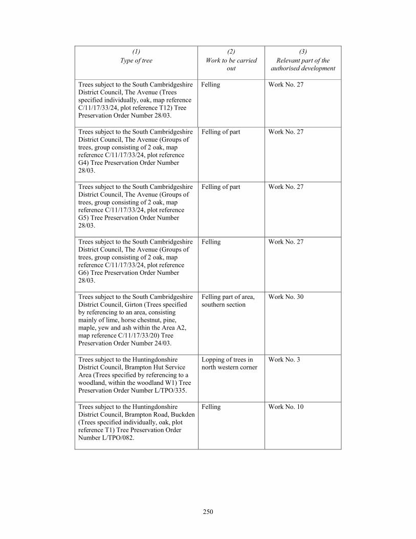
250
(1)
Type of tree
(2)
Work to be carried
out
(3)
Relevant part of the
authorised development
Trees subject to the South Cambridgeshire
District Council, The Avenue (Trees
specified individually, oak, map reference
C/11/17/33/24, plot reference T12) Tree
Preservation Order Number 28/03.
Felling Work No. 27
Trees subject to the South Cambridgeshire
District Council, The Avenue (Groups of
trees, group consisting of 2 oak, map
reference C/11/17/33/24, plot reference
G4) Tree Preservation Order Number
28/03.
Felling of part Work No. 27
Trees subject to the South Cambridgeshire
District Council, The Avenue (Groups of
trees, group consisting of 2 oak, map
reference C/11/17/33/24, plot reference
G5) Tree Preservation Order Number
28/03.
Felling of part Work No. 27
Trees subject to the South Cambridgeshire
District Council, The Avenue (Groups of
trees, group consisting of 2 oak, map
reference C/11/17/33/24, plot reference
G6) Tree Preservation Order Number
28/03.
Felling Work No. 27
Trees subject to the South Cambridgeshire
District Council, Girton (Trees specified
by referencing to an area, consisting
mainly of lime, horse chestnut, pine,
maple, yew and ash within the Area A2,
map reference C/11/17/33/20) Tree
Preservation Order Number 24/03.
Felling part of area,
southern section
Work No. 30
Trees subject to the Huntingdonshire
District Council, Brampton Hut Service
Area (Trees specified by referencing to a
woodland, within the woodland W1) Tree
Preservation Order Number L/TPO/335.
Lopping of trees in
north western corner
Work No. 3
Trees subject to the Huntingdonshire
District Council, Brampton Road, Buckden
(Trees specified individually, oak, plot
reference T1) Tree Preservation Order
Number L/TPO/082.
Felling Work No. 10

251
(1)
Type of tree
(2)
Work to be carried
out
(3)
Relevant part of the
authorised development
Trees subject to the Huntingdonshire
District Council, Ermine Street
Godmancheaster (Trees specified by
referencing to an area, within the Area A1)
Tree Preservation Order Number
L/TPO/260.
Felling Work Nos. 5 & 13
Trees subject to the Huntingdonshire
District Council, Hinchingbrooke Park,
Huntingdon (Trees specified individually,
oak, plot reference T3) Tree Preservation
Order Number 003/59.
Felling Work No. 34
Trees subject to the Huntingdonshire
District Council, Hinchingbrooke Park,
Huntingdon (Woodland, plot reference
W1) Tree Preservation Order Number
003/59.
Felling Work No. 34
Trees subject to the Huntingdonshire
District Council, Hinchingbrooke Park,
Huntingdon (Groups of trees, group
consisting of 20ash, 1 oak, 5 false acacia,
15 hawthorn, 1 birch, 5 hornbeam, 1
maple, 3 cherry, plot reference G7) Tree
Preservation Order Number 003/59.
Felling Work No. 34
252
SCHEDULE 10 Article 41
DOCUMENTS TO BE CERTIFIED
(1)
Document
(2)
Description
the book of reference the book of reference contained in document
reference HE/A14/EX/226
the borrow pit restoration and aftercare strategy the borrow pit restoration and aftercare strategy
contained in document reference
HE/A14/EX/207
the classification of roads plans sheets 1-2 contained in document reference
2.12
the code of construction practice
the code of construction practice contained in
document reference HE/A14/EX/205
the crown land plans sheets 8, 13, 29 and 30 contained in document
reference HE/A14/EX/220
the de-trunking plans
sheets 1-15 contained in document reference
HE/A14/EX/219
the engineering section drawings
sheets 1-59 contained in document reference
HE/A14/EX/221
the environmental statement [ ]
the flood risk assessment
the flood risk assessment contained in
document reference HE/A14/EX/200
the general arrangement drawings sheets 1-24 and Huntingdon Town 1 and
Huntingdon Town 2, plus Legend and Key
Plan, contained in document reference
HE/A14/EX/215
the land plans sheets 1-40 contained in document reference
HE/A14/EX/216
the rights of way and access plans sheets 1-28 contained in document reference
HE/A14/EX/218
the special category land plans
sheets 1-2 contained in document reference
HE/A14/EX/224
the traffic regulation measures: clearways and
weight limit plans
sheets 1-28 contained in document reference
HE/A14/EX/223
253
(1)
Document
(2)
Description
the traffic regulation measures: speed limits &
prohibitions plans
sheets 1-29 contained in document reference
HE/A14/EX/222
the variation of special road status plan
sheet 1 of 1 contained in document reference
2.6
the works plans sheets 1-29 contained in document reference
HE/A14/EX/217
the written scheme of investigation:
archaeological investigations
the outline written scheme of investigation
contained in document reference
HE/A14/EX/231
254
EXPLANATORY NOTE
(This note is not part of the Order)
This Order authorises Highways England Company Limited to improve the A14 between
Cambridge and Huntingdon. These improvements extend from Ellington to the Cambridge
Northern Bypass at Milton and include the provision of a new bypass to the south of Huntingdon.
The Order would permit Highways England Company Limited to acquire, compulsorily or by
agreement, land and rights in land and to use land for this purpose.
The Order also makes provision in connection with the maintenance of the authorised
development.
A copy of all relevant plans, drawings and sections, the book of reference and the environmental
statement mentioned in this Order and certified in accordance with article 41 of this Order
(certification of plans, etc.) may be inspected free of charge during working hours at Highways
England Company Limited, Woodlands, Manton Lane, Bedford, Bedfordshire MK41 7LW.
255
S T A T U T O R Y I N S T R U M E N T S
201[ ] No.
INFRASTRUCTURE PLANNING
The A14 Cambridge to Huntingdon Improvement Scheme
Development Consent Order 201[ ]
Pinsent Masons LLP
30 Crown Place
Earl Street
London
EC2A 4ES
28 September 30 October 2015
Recommended