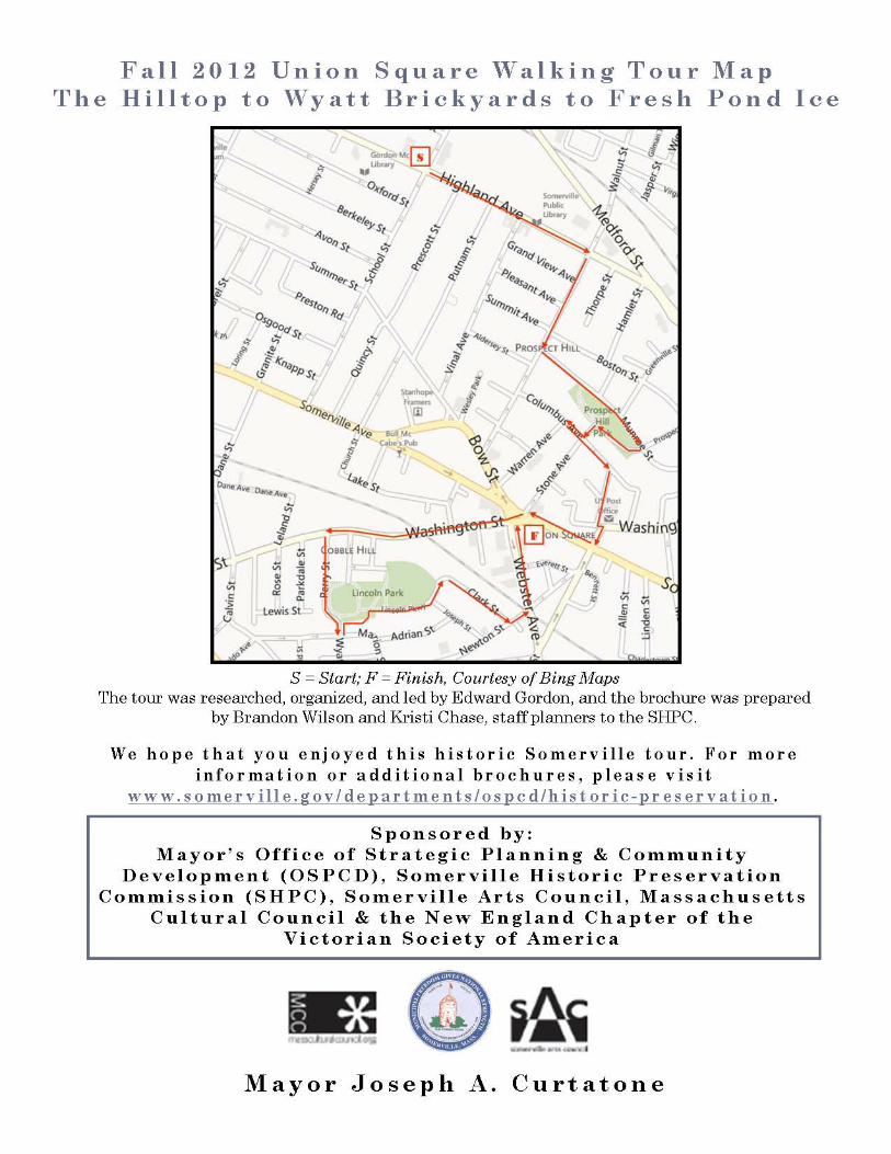
ArtsUnion Walking Tour of Union Square, Fall 2012
“Historic Somerville: Its Civic Hilltop to the Wyatt Brothers Brickyards and Fresh Pond Ice”
Researched and Led by Edward W. Gordon, President,
Victorian Society in America, NE Chapter
This walking tour explores some of the most striking features of Somerville’s historic land uses
– starting with its hilltop civic center, continuing through its lofty Prospect Hill residential
neighborhood, and ending with some vintage commercial buildings in Union Square and
industrial sites in Ward 2, that were once associated with brick‐making and ice distribution.
The walk will highlight the various personalities, land‐making projects, and transportation
improvements, as well as the forces outside Somerville, that helped shape the City’s
architecture and development pattern.
Somerville was long known as “the land beyond the neck.” This was due to its location along
the narrow strip, or neck of land at Sullivan Square that linked Somerville to Charlestown prior
to land‐making in the late 1800s. The residents separated from Charlestown in 1842 and
established their own town. This independence stemmed from the introduction of rail lines in
the future Town during the 1830s, and the almost immediate rise of industries along their
length. The majority of the buildings noted on this tour were built during a forty year span,
from 1870‐1910. This period occurred shortly before Somerville incorporated as a city in 1872
and lasted until the onset of World War I in the 1910s. During this era of tremendous growth
Union Square rose as a major center for the City’s commercial, spiritual, and industrial life. Its
brick industry declined as resources were depleted and land became more valuable for house
construction by the 1880s. Earlier industries, such as the American Tube Works, meat packing
concerns, glass works, and others, expanded significantly at the periphery of the Square. From
1890‐1910 an unprecedented building boom created fifty percent (50%) of the City’s current
housing stock, while the population shot up from 40,152 to 77,236!

2012 Union Square Walking Tour – The Hilltop to Wyatt Brickyards to Fresh Pond Ice
2
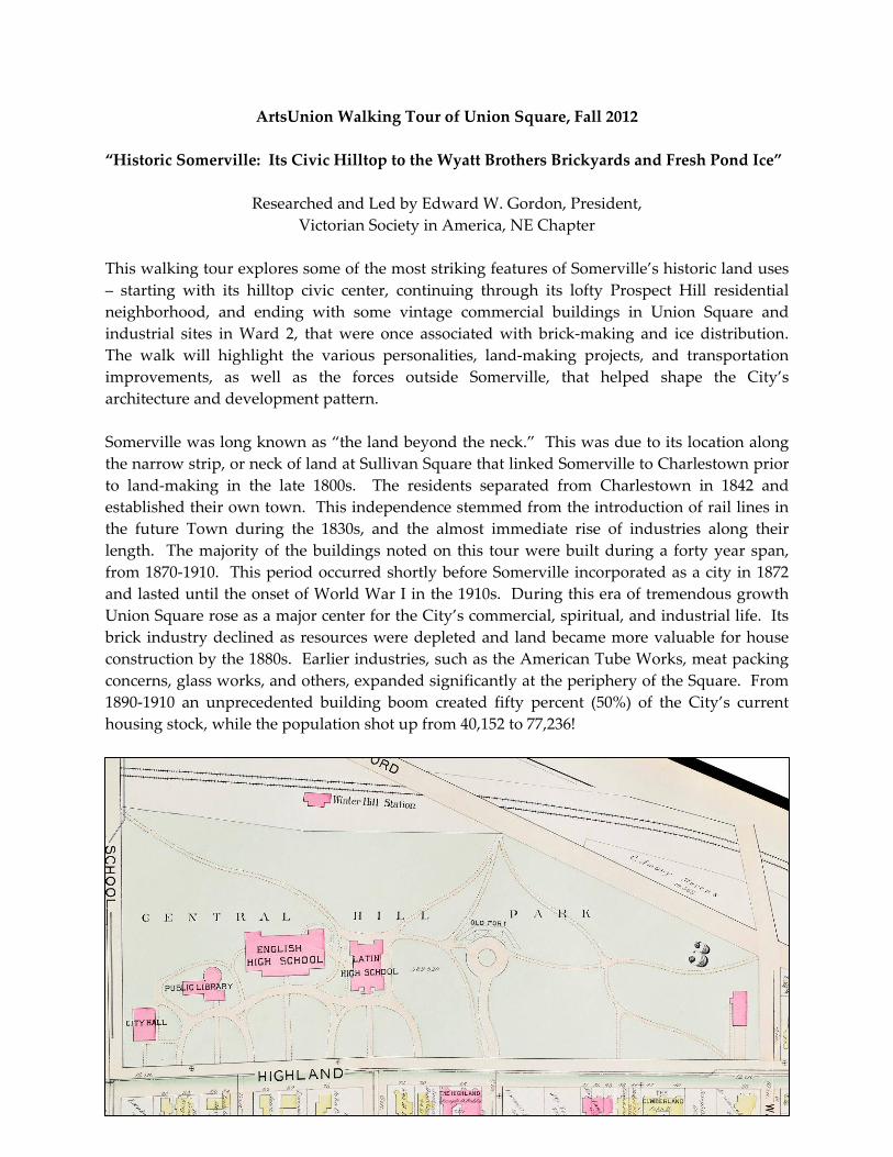
The Municipal Civic Center in Central Hill Park
The Municipal Civic Center in Central Hill Park
Central Hill includes the area between Highland Avenue and the streets of School, Walnut and
Medford. Here one finds Somerville’s City Hall, comprehensive High School, and Central
Library, as well as a wonderful collection of civic sculptures, set off by a leafy Central Hill Park,
the City’s oldest public green space. During the late 1700s, this hilltop land was called “the
Church lots” because it was owned by the First Church of Charlestown. It was later purchased
in 1870 from Jacob Sleeper of Boston, one of the founders of Boston University, at a cost of
$38,000 to the Town. Indeed, Central Hill Park was the only dedicated parkland pre‐dating the
City’s incorporation in 1872. Although Central Hill has been the civic center of the community
for over 150 years it has evolved significantly, with many alterations, demolitions and changes
of use to the buildings atop it. A viewing of old photographs, for example, depicts a high
school, library and fire station that predate their modern counterparts. The north side of this
civic campus has an outstanding panoramic view of Winter Hill over the rooftops of Gilman
Square edifices. The middle of the park represents the site of the French Redoubt where troops
gathered at the onset of the American Revolution, determined to overthrow their British
oppressors.
Central Hill in 1895
The current City Hall
building has changed
greatly over time, with a
series of alterations and
adaptive reuse additions.
The nucleus of this
pressed brick building is
a high school built in the
Greek Revival style in
1852. In 1866, six years
before Somerville was
incorporated as a City,
Town officials moved
their offices from a
building on Forster Street
to the second floor of this
high school atop Central Hill. In 1873 the Police Court moved out of City Hall into a new
headquarters on Bow Street, and a public library was installed in its former space. Then the
library moved into a building of its own in 1885, located between City Hall and a Latin School.
The first major enlargement occurred in 1896 when a rear wing designed by Thomas T. M.
Sargent was added behind the Highland Avenue side of the building. In 1924 a second, more
radical alteration occurred using the designs of Ritchie, Parsons and Taylor, a Boston
architectural firm. The entire orientation and size of the building was changed with the
addition of a large north wing that housed a chamber for the Board of Aldermen on the second

2012 Union Square Walking Tour – The Hilltop to Wyatt Brickyards to Fresh Pond Ice
3
floor. This resulted in symmetrical east and west facades, as well as a generally more imposing
appearance. The gable end pediment of the original building was removed and a third story
was added. The entrance was relocated to the original main block where it still remains. Key
elements include such Classical Revival details as the two colossal Ionic columns set in antis, the
broad wood spandrels between the first and second story windows, and the addition of a clock
tower, spire and weather vane. Columns are ʹin antisʺ when they stand between square piers
call anta.
The sculpture positioned directly in front of City Hall, facing
Highland Avenue commemorates the heroic war death of
23‐year‐ old Somerville resident George Dilboy. He is
thought to be the first Greek‐American to receive the Medal
of Honor during World War I. He earned it for leading an
attack on a machinegun position and continuing to fire at
the enemy despite being seriously wounded. Before falling
himself, he killed two of the enemy and dispersed the
remainder of the gun crew. General John Pershing listed
Dilboy as one of the 10 greatest heroes of the war. The
monument was commissioned and paid for by the American
Hellenic Educational Progressive Association. The Dilboy
portrait bust was created by an unidentified sculptor
associated with the Grenier Studio in Boston. The photo
depicts the unveiling in a public outdoor ceremony in August, 1931, which was attended by
City and religious dignitaries, schoolgirls portraying allegories, and an amazingly large crowd,
estimated at 4,000.
Close by to City Hall sits Somerville High School, a sprawling three‐story brick building
enlivened by terra cotta and brownstone
trimmings. Somerville High School encompasses
an 1896 central tripartitie building that represents
the work of the important Boston architectural
firm of Hartwell and Richardson‐‐a firm that
designed the former Exeter Street Theatre in
Bostonʹs Back Bay in 1886 and the Cambridge
City Hall in 1889. The 1896 structural component
of the building was originally enclosed by a
massive hip roof that was destroyed by fire
during the 1960s. The High Schoolʹs east and west wings were added in 1928 by Frank I Cooper
Contractors with a horizontal orientation amplified by brownstone sills and belt courses on the
upper stories. The building blends elements of the Italian Renaissance and Classical Revival
styles—the arched windows of the main blocks on the third story present a pleasing repetition
of curved lines.. The Romanesque Revival library of 1885 was demolished to accomodate the
1928 west wing.

2012 Union Square Walking Tour – The Hilltop to Wyatt Brickyards to Fresh Pond Ice
4
Continue eastward along the civic center campus past the most modern addition (1986‐87) that houses
the technical education component of the SHS to the Civil War Memorial.
The Somerville Civil War Memorial, also called “American Valor,” was designed in 1908 by
the highly accomplished Augustus Lukeman.
Dedicated atop Central Hill on May 31, 1909, the
ceremony was presided over by none other than
the former Governor of Massachusetts, Curtis
Guild. The City’s Poet Laureate, Sam Walter
Foss, read his poem entitled “The Unrewarded
Dead.” The bronze figures, cast by the Gorham
Company of Providence Rhode Island, depict an
angel serving as a bodyguard for a marching
soldier. The granite base was created by
Lukeman’s assistant, George B. Howe. Mr. Lukeman, born in Richmond Virginia in 1870,
studied in New York and Paris, and was part of an art colony in Stockbridge, MA that revolved
around the great American sculptor, Daniel Chester French. One of Lukeman’s early projects
was a design for a statue in Adams, MA that commemorated the assassinated President William
McKinley. Lukeman’s most renowned work is the Confederate Memorial (1916‐1925), a
sculptural bas relief, situated on the steep granite slopes of Stone Mountain, just north of
Atlanta, Georgia.
If the Somerville Public Library at 79 Highland Avenue looks like a not‐so‐distant cousin of
the Boston Public Library (BPL) at Copley Square, indeed, it is. Early in his career, the architect
for the Central Library, Edward Lippincott Tilton (1861‐1933), worked for the firm McKim,
Mead and White, that designed the BPL. Both the Boston and Somerville libraries were
designed to look like over‐sized Italian Renaissance palaces. Interestingly, all three of
Somerville’s public libraries were among the hundreds funded by Andrew Carnegie, the
famous steel magnate based in Pittsburgh, Pennsylvania. As a poor boy of high intelligence
Carnegie grew up in Scotland, and was invited to study in the private library of a wealthy
family. He credited his later success to the early access to books, and this inspired him to fund
public libraries throughout America during his lifetime.
Directly in front of the Central Library is the Spanish War
Monument. The impressive piece commemorates the service of
Somerville veterans in two armed conflicts against Spain, in Cuba
and the Philippines at the turn‐of‐the‐twentieth century, as well
as in a third conflict in Asia. Officially known as the China Relief
Expedition, this conflict was called the Boxer Rebellion by western
journalists. Nicknamed Boxers by the western press, this group of
radical northern Chinese extremists were called ʺthe Righteous
and Harmonious Fistsʺ in China‐‐a fringe group that had an
unfortunate record of harrassing and killing Chinese Christians
and westerners based in China from 1900‐1901.

2012 Union Square Walking Tour – The Hilltop to Wyatt Brickyards to Fresh Pond Ice
5
Sculptor Raymond A. Porter (1883‐1949) was responsible for the design of the monument. Its
12’ granite base is topped by a 3‐4’ bronze eagle, while its side ledges hold two bronze figures
depicting a soldier and a sailor. Dedicated in December 1929, the casting of the bronze eagle
and flanking figures is credited to T.F. McGann and Sons Company of Somerville. Sculptor
Raymond Averill Porter was born in Hermon, New York in 1883. He later lived and worked as
a teacher and sculptor in Chicago during the early 1900s, and later in Chelmsford, Watertown,
and Boston, MA. He taught at the Boston Museum School of Fine Art.
From the Library cross Highland Avenue and proceed southward on Walnut Street for the Prospect Hill
neighborhood part of the tour.
Prospect Hill is a drumlin of 115 feet, and Somerville’s highest eminence. The Hill is bound by
Highland Avenue, McGrath Highway, and Washington Street in the Union Square area.
Walnut Street is one of eleven very old rangeways or county roads that run all the way from
Franklin Street in East Somerville to North Street in West Somerville, and that hark back to
Colonial Times. The range ways along Broadway and Milk Row, now known as Somerville
Avenue, enabled agricultural and dairy products from outlying farms to reach the markets of
Charlestown, Cambridge and Boston. Very few houses were located on Walnut Street until
around 1850 when the Munroes, Vinals and Hills began to develop the upper south slope of
Prospect Hill.
Built 1860‐1865, 67 Walnut Street is a well‐
preserved example of an Italianate house that
provides evidence of houses being built in
Somerville during the Civil War, in spite of that
era’s turbulence and uncertainty. It does not
appear on the 1857 map of Somerville, and the
earliest known owner is Abraham Folsom of
Boston, listed here by 1865. During the 1870s,
Lydia and Caleb Duxbury owned this property,
while Edwin Ireland lived here beginning c.1875.
He was undoubtedly a descendant of the Ireland
family of farmers who settled in Somerville well
before the American Revolution.
A cluster of architecturally distinguished houses
representing three distinct stages in the
development of Prospect Hill can be seen at the
intersection of Summit Avenue, and Boston and
Walnut Streets. The first is a Greek Revival
residence at 91 Boston Street built circa 1850 for
realtor Ira Hill. A verandah and 2‐story bay were
2012 Union Square Walking Tour – The Hilltop to Wyatt Brickyards to Fresh Pond Ice
6
added during the 1890s. Then across from this, built circa 1870, is the Italianate mansard
residence of businessman George Simpson at 48 Walnut Street. Now look at two striking
Queen Anne houses on the left: the palatial, towered residence of provisions dealer Louisville
Niles at 45 Walnut Street built in 1890, and the enormous double house at 3 Summit Avenue
constructed in 1888 for George Hill and his son. Amazingly each unit contained twelve rooms,
plus a reception hall with a bath and a laundry!
82 Munroe Street – “The Grandview.” Samuel Kelley designed this early apartment building
on the ridge of Prospect Hill. The original owner was Elbridge Park, co‐owner of the famous
Durgin Park restaurant in the Quincy Market area of Boston.
88 Munroe Street was constructed for Benjamin S. and Hannah Munroe in two stages, during
the 1850s and 1880s. Benjamin was the son of prosperous grain dealer Robert Munroe, who
along with Robert Aldersey and Ira Hill, began to subdivide Prospect Hill for residential house
lots around 1850.
2 Bigelow Street is a well‐preserved example of both the Stick style and Queen Anne style built
in 1886 for Boston Paint dealer Henry A. Robbins. The contractor was Ivory Bean, significant
for his construction of the St. Botolph Street neighborhood in Boston in the 1890s. Nearby 10
Bigelow Street was built in 1887, and boasts one of the finest encircling verandas in the City.
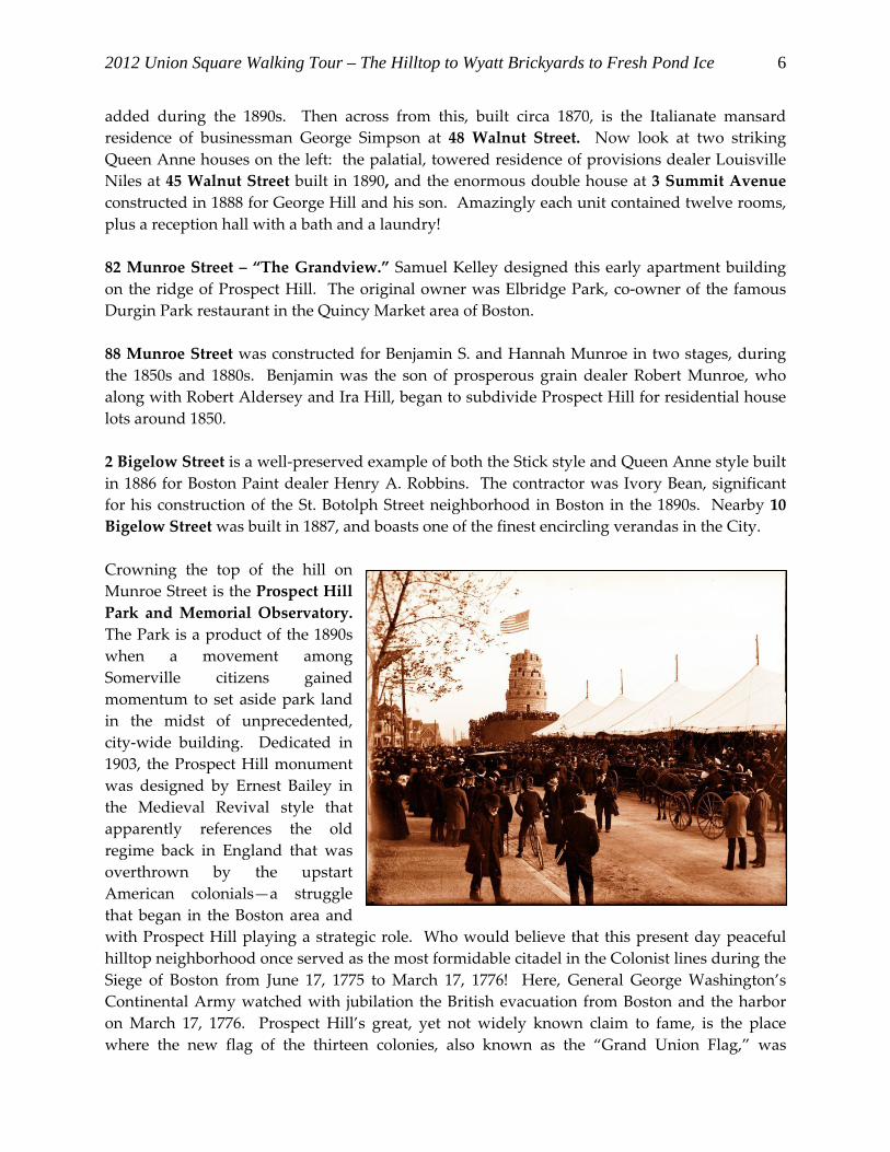
Crowning the top of the hill on
Munroe Street is the Prospect Hill
Park and Memorial Observatory.
The Park is a product of the 1890s
when a movement among
Somerville citizens gained
momentum to set aside park land
in the midst of unprecedented,
city‐wide building. Dedicated in
1903, the Prospect Hill monument
was designed by Ernest Bailey in
the Medieval Revival style that
apparently references the old
regime back in England that was
overthrown by the upstart
American colonials—a struggle
that began in the Boston area and
with Prospect Hill playing a strategic role. Who would believe that this present day peaceful
hilltop neighborhood once served as the most formidable citadel in the Colonist lines during the
Siege of Boston from June 17, 1775 to March 17, 1776! Here, General George Washington’s
Continental Army watched with jubilation the British evacuation from Boston and the harbor
on March 17, 1776. Prospect Hill’s great, yet not widely known claim to fame, is the place
where the new flag of the thirteen colonies, also known as the “Grand Union Flag,” was

2012 Union Square Walking Tour – The Hilltop to Wyatt Brickyards to Fresh Pond Ice
7
unfurled in defiance of the British for the first time, on January 1, 1776. One of the last great
skirmishes between the British Red Coats and local Minutemen occurred on April 19, 1775 at
the base of Prospect Hill in the Union Square area, and the Hill was the site of a British prisoner
of war camp in 1777‐1778. In the early 1860s Prospect Hill was once again host to a sizeable
encampment of soldiers—recent recruits soon to be fighting further south for the Union cause.
Come back to the Park on noon of January 1st for a moving program that annually
commemorates the raising of the Grand Union Flag.
Rounding the eastern corner of Prospect Hill Park,
descend to Columbus Avenue via the sidewalk that
runs along Prospect Hill Parkway. Turn right and
proceed to the corner of Warren Street and Columbus
Avenue to consider the impressive concentration of
substantial Second Empire residences on these streets.
Columbus Avenue was set out around 1870 on
land owned by Ira Hill, one of the early
homeowners of the neighborhood atop Prospect
Hill. This street was variously called High Street and Warren Avenue until circa 1880 when the
street became known as Columbus Avenue. Few communities in Massachusetts can boast such
a fine concentration of houses designed in the Mansard or Second Empire style. Particularly
noteworthy in terms of their substantial forms, Italianate elements, and towered center
pavilions are the circa 1880 houses of James H. Brooks and S.E Brackett House at 61 and 63
Columbus Avenue, respectively along with the houses descending Warren Avenue. Note
features such as bay windows, rope mouldings, towered center pavilions and Italianate
brackets, as well as the substantial volumes of the mansard roofs.
Now turn eastward to follow the thoroughfare as far as Bonner Avenue, and walk right by Homer Court,
a charming cul‐de‐sac bordered by Italianate and Mansard style houses. Also noteworthy on the east side
of the street is the circa 1845 Greek Revival house originally owned by William B. Bonner. Bonner
Avenue may have started out as a carriage way leading to Bonner’s house which has sustained a few
alterations, but retains its sizeable lot which is currently graced with lovely gardens.
2012 Union Square Walking Tour – The Hilltop to Wyatt Brickyards to Fresh Pond Ice
8
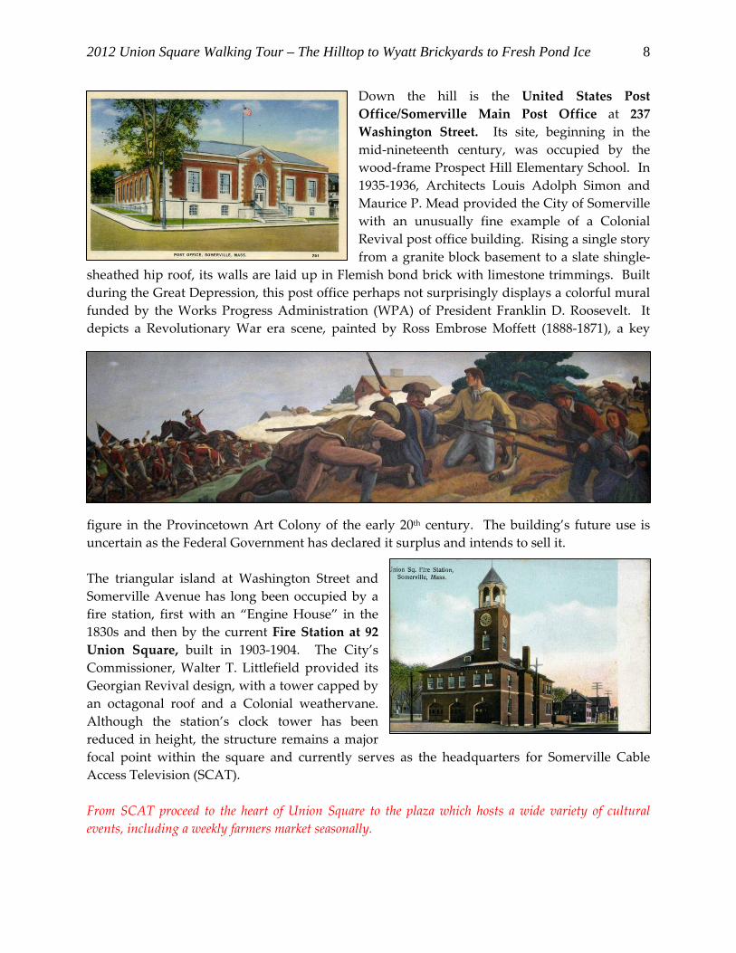
Down the hill is the United States Post
Office/Somerville Main Post Office at 237
Washington Street. Its site, beginning in the
mid‐nineteenth century, was occupied by the
wood‐frame Prospect Hill Elementary School. In
1935‐1936, Architects Louis Adolph Simon and
Maurice P. Mead provided the City of Somerville
with an unusually fine example of a Colonial
Revival post office building. Rising a single story
from a granite block basement to a slate shingle‐
sheathed hip roof, its walls are laid up in Flemish bond brick with limestone trimmings. Built
during the Great Depression, this post office perhaps not surprisingly displays a colorful mural
funded by the Works Progress Administration (WPA) of President Franklin D. Roosevelt. It
depicts a Revolutionary War era scene, painted by Ross Embrose Moffett (1888‐1871), a key
figure in the Provincetown Art Colony of the early 20th century. The building’s future use is
uncertain as the Federal Government has declared it surplus and intends to sell it.
The triangular island at Washington Street and
Somerville Avenue has long been occupied by a
fire station, first with an “Engine House” in the
1830s and then by the current Fire Station at 92
Union Square, built in 1903‐1904. The City’s
Commissioner, Walter T. Littlefield provided its
Georgian Revival design, with a tower capped by
an octagonal roof and a Colonial weathervane.
Although the station’s clock tower has been
reduced in height, the structure remains a major
focal point within the square and currently serves as the headquarters for Somerville Cable
Access Television (SCAT).
From SCAT proceed to the heart of Union Square to the plaza which hosts a wide variety of cultural
events, including a weekly farmers market seasonally.

2012 Union Square Walking Tour – The Hilltop to Wyatt Brickyards to Fresh Pond Ice
9
Union Square was initially called ʺSand Pit Squareʺ because its sandy, clay pit‐dotted areas
yielded a fine grade of silica used in glass and brick‐making. Union Square became a major
commercial center due to its location at an important crossroads in eastern Somerville. The
Square’s major thoroughfares, Washington Street, Prospect Street and Somerville Avenue
(formerly Charlestown Lane and Milk Row), originated as seventeenth and eighteenth century
trade routes. Middlesex County farm products were hauled through the Square to be sold at
markets in Charlestown and Boston. The first railroad lines were introduced near the Square
during the 1830s and 1840s which further spurred area residential and commercial
development.
The mid‐nineteenth century witnessed the rise of industries south and west of the Square, such
as the Union Glass Company and American Tube Works, as well as numerous small
woodworking shops, ice businesses, carriage‐making and brick manufacturing concerns. The
success of these enterprises insured that Union Square was an important contributor to the
commercial prosperity of Somerville well into the twentieth century. The Square served as a
major recruitment center during the Civil War and became known as ʺLiberty Pole Square”
after Somerville firemen erected a flag pole in the center of the Square. The name “Union
Square” references the Union of northern states that fought the southern Confederate States of
America during the Civil War. Union Square was host to a Union Army recruitment station
and an encampment of Union troops atop Prospect Hill.
Following the Civil War, both Union and Davis Squares evolved into larger commercial centers
serving a rapidly growing community. In 1872 Somerville incorporated as a City, and between
1870 and 1920, its population increased six fold –from 14,685 in 1870 to 93,091 by 1920! Over
time waves of immigrants have called Union Square home ‐‐ from the Irish of the mid‐
nineteenth century to the Italians, Greeks and Portuguese of the early 20th century, and in more
recent times to members of the Brazilian, Haitian and Hispanic communities.
The wood‐frame Robert A. Vinal House at 15
Union Square is the sole survivor of the earliest
residential development in Union Square. Vinal,
a grain dealer operating in the Square, built the
circa 1845 Greek Revival house that was later
converted to commercial use. Old photographs
show a much larger Greek Revival end gable
building on the west side of Vinal’s building
known as “The Oasis” which housed a grocery
store and was also a popular meeting place for
the town’s residents.
Striking an elegant design note on the north side of the paved pedestrian plaza is the former
Somerville Police Headquarters. Built in 1932 from designs provided by an unidentified
architect, this building was the successor to the first Police Headquarters building that still
stands on Bow Street. It evidences several different architectural styles: Italian Renaissance

2012 Union Square Walking Tour – The Hilltop to Wyatt Brickyards to Fresh Pond Ice
10
Revival on the main façade, in the console keystone arch above the front doors, and the
rusticated concrete on the first story; Georgian Revival in the second story’s segmental arched
window and stone corner quoins; and Federal Revival with its wedge‐shaped key stone
window lintels, Ionic pilasters, and paneled parapet. The only facility of its type in Somerville,
it housed more than 150 officers and a constabulary when it opened its doors in 1933. In the
mid‐1980s, the City consolidated the police and fire department headquarters in a rehabilitated
MBTA garage at 218‐220 Washington Street. The 1932 building subsequently was adapted for
reuse as a mixed‐use building with offices and a restaurant, initially the first Elephant Walk in
the Boston area.
Although drastically altered by a mid‐1970s modernization,
the Stone Building (also known as Barrister’s Hall) at 57‐61
Union Square retains its original form and prominent corner
site. For many years this building housed the Somerville
Savings Bank. The building was built in 1891 at the behest
of Jonathan Stone, the bank’s treasurer. Stone’s family had
deep roots in Somerville—with the first Stones settling in
Somerville well before the American Revolution. During the
early 1990s, Be Sargent Allen, a well‐known Somerville
artist, painted the mural on the east side of the building that
commemorates the Grand Union Flag Raising on Prospect
Hill in 1776.
From the Stone Building cross over to the corner of Washington
Street and Somerville Avenue to the Church.
St. Joseph’s Roman Catholic Church, at
Washington and Webster Streets, was built in
1870‐1874 in the Gothic Revival style from plans
provided by James Murphy. Somerville’s
notable population of 2,000 Catholics
was forced to walk considerable distances to
worship in churches in Charlestown and
Cambridge. On January 20, 1870, the
congregation purchased the Mayo estate, and
architect James Murphy designed a first house
of worship for Catholics. In 1871, Monsignor
Christopher C. McGrath held the first services in
the lower church, and presided over the
congregation for the next sixty‐three years! Sadly,
the church steeple was taken down in 1978
for fear that structural instability would
cause it to collapse. Union Square lost a
significant and very striking landmark. The

2012 Union Square Walking Tour – The Hilltop to Wyatt Brickyards to Fresh Pond Ice
11
cross can be seen in the front yard.
Head southwest on Washington Street to view the Second Empire William H. Burt House (1874) at
264 Washington Street, noteworthy for its formal center pavilion which rises to a pyramidal mansard
roof. Next door is the former St. Joseph’s Roman Catholic Parochial School at 268‐272
Washington Street built in 1890 and converted to 20 residential units in 1981 by the Somerville
Housing Authority.
In contrast to the prominence of St. Joseph’s in Union Square, the
former St. Thomas Episcopal Church has been largely forgotten,
hidden from view by a tight cluster of trees, houses and commercial
buildings. From the foot of 269 Washington Street’s driveway,
however, one can glimpse part of its south wall. St. Thomas was
designed in the Gothic Revival style (1870‐1875) by the construction
firm of George Trefren & Son. It is a one‐and‐one‐half story, end
gable building with a brick foundation that supports walls whose
board and batten siding is currently covered with vinyl. The
building started out as a rectangular hall measuring 25 feet by 70
feet. By 1897 a vestibule and spire‐surmounted tower enlivened the
northwest corner. Between 1907 and 1913 the side aisles and chancel originally planned for the
building were added to the south end. The tower was taken down around 1930 and by then,
the vestibule on the main Somerville Avenue façade had achieved its present full length. The
church beginnings are rooted in St. John’s Episcopal Church on Devens Street in Charlestown.
The first pastor, George W. Durrell, presided over a congregation of just over 130 parishioners
from 1870‐1895. During the 1960s the congregation dissolved and since then the building has
housed a nursery school, Haitian and Hispanic religious groups, and non‐profit agencies.
Note the circa 1870 Victorian residences bordering Washington Street between the Sherman Café and
Hawkins Street. Together with the church buildings across the street, these Victorian era residences
provide a fine vintage streetscape at one of Union Square’s key western entrances.
269 Washington Street is a solid example of the Mansard style, while 273 Washington Street is
a well‐preserved Italianate house configured with a side hall plan. It was originally owned by
John Ashley, a Boston lamp fixtures dealer. The wood‐frame double house at 277‐275
Washington Street was originally designed in a more Italianate style, but it acquired a third
story and a more Federal Revival sensibility during the early 20th century. During the 1870s,
John G. Smith, a superintendent at Metallic Art Works in East Cambridge, lived here.
The two‐
story red
brick, flat
roofed
industrial
building at
2012 Union Square Walking Tour – The Hilltop to Wyatt Brickyards to Fresh Pond Ice
12
285 Washington Street, corner of Hawkins Street, originally housed the I.H. Brown Moulding
Company. The building dates to the late 1880s and is typical of the carpentry and
woodworking concerns that rose to the fore during the boom years of Cambridge and
Somerville’s expansion. The Brown Co. moved here in 1886 after a fire destroyed their
headquarters in Cambridge. The company specialized in mouldings of all descriptions, in
addition to window frames, sashes, drawer cases, and the like. One of the company’s
specialties was wooden exhibition cases for museums, including Harvard University’s Agassiz
Museum of Natural History.
By 1928, its first floor was used for sawing and planing, the second floor for cabinet work, and
the basement for planing and storage. The building currently houses Burma Designs, the
Fringe Artist Design Cooperative, and Moroccan Caravan, while Metro Pedal Power rents space
in the basement.
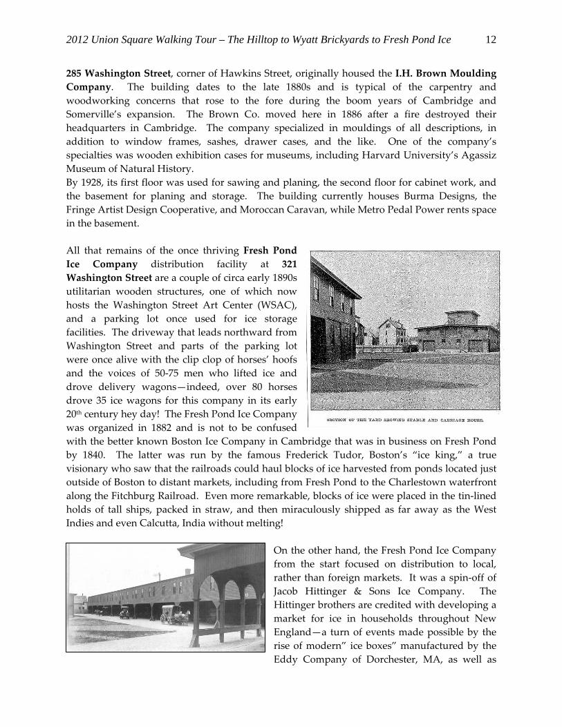
All that remains of the once thriving Fresh Pond
Ice Company distribution facility at 321
Washington Street are a couple of circa early 1890s
utilitarian wooden structures, one of which now
hosts the Washington Street Art Center (WSAC),
and a parking lot once used for ice storage
facilities. The driveway that leads northward from
Washington Street and parts of the parking lot
were once alive with the clip clop of horses’ hoofs
and the voices of 50‐75 men who lifted ice and
drove delivery wagons—indeed, over 80 horses
drove 35 ice wagons for this company in its early
20th century hey day! The Fresh Pond Ice Company
was organized in 1882 and is not to be confused
with the better known Boston Ice Company in Cambridge that was in business on Fresh Pond
by 1840. The latter was run by the famous Frederick Tudor, Boston’s “ice king,” a true
visionary who saw that the railroads could haul blocks of ice harvested from ponds located just
outside of Boston to distant markets, including from Fresh Pond to the Charlestown waterfront
along the Fitchburg Railroad. Even more remarkable, blocks of ice were placed in the tin‐lined
holds of tall ships, packed in straw, and then miraculously shipped as far away as the West
Indies and even Calcutta, India without melting!
On the other hand, the Fresh Pond Ice Company
from the start focused on distribution to local,
rather than foreign markets. It was a spin‐off of
Jacob Hittinger & Sons Ice Company. The
Hittinger brothers are credited with developing a
market for ice in households throughout New
England—a turn of events made possible by the
rise of modern” ice boxes” manufactured by the
Eddy Company of Dorchester, MA, as well as

2012 Union Square Walking Tour – The Hilltop to Wyatt Brickyards to Fresh Pond Ice
13
others in America. However, during the 1880s, just as the Fresh Pond Company was beginning
to prosper, the City of Cambridge was mounting a campaign to banish the two ice companies
from the shores of Fresh Pond so that it could be used exclusively as a reservoir for public
drinking water. By 1891 the ice companies were no longer a presence on the pond and Fresh
Pond Ice had to move its operations to Brookline, New Hampshire. The ice was then shipped to
Boston in refrigerated cars via the Boston & Maine Railroad.
The Somerville distribution facility for the Fresh Pond Ice Company was established on the
former Hawkins Estate during the 1890s. This parcel is wedged in between the Fitchburg (later
B & M) Railroad and Washington Street, and by 1900, it encompassed two large ice storage
sheds and three much smaller buildings—one of which survives as the Washington Street Art
Center building/art gallery. The ice that was stored in Somerville was harvested from Lake
Muscatanipus in New Hampshire. In contrast to the Somerville distribution facility, the
Brookline headquarters of the company was much larger, encompassing eleven immense ice
houses which had a storage capacity of 70,000 tons! Over 250 New Hampshire men were
employed in harvesting “the ice crop.” Famous for the purity of its frozen water, the Fresh
Pond Ice Company went out of business after a fire destroyed its New Hampshire facility in
1935 and electric refrigerators became common.
Cross Washington Street and continue south down Perry Street, originally named North Wyatt Street, to
Lincoln Park. Perry Street was named in memory of Mayor Albion Perry, in office from 1896‐1898.

2012 Union Square Walking Tour – The Hilltop to Wyatt Brickyards to Fresh Pond Ice
14
Lincoln Park, one of Somerville’s oldest recreation areas, was planned as early as 1896. The
park’s lawns and walks were in place by 1900, although the small pond at its southwest corner
was filled in during the transition from brick yard to public green space. Lincoln Park occupies
the site of George Wyatt’s brickyards which were called “Wyatt’s Pitts” by local residents.
George Wyatt lived nearby at 33 Beacon Street. The brick industry was a major component of
Somerville’s economy from 1820‐1880. Somerville’s soil was well‐suited for brick‐making, and
it was a commercial pursuit primarily conducted in parts of the City bordering waterways, such
as the Miller’s River (now completely filled‐in) in eastern Somerville, and especially along the
Mystic River. In addition, the Tufts brickyards once dominated the landscape west of Cedar
Street. The demise of Somerville’s brick‐making industry was due to the higher value placed on
land for house construction. The last brickyards shut down during the late 1890s when the
William A. Sanborn family closed their concern, open since 1849. According to the late 19th
century Somerville atlases the Wyatt brickyards consisted of a long rectangular structure
bordering the Washington Street edge of the property, and a line of contiguous chimneys and
kilns just to the south of the shed. Clay pits took up the remaining land that extended south to
Lincoln Parkway.
On the northeast side of Lincoln Park sits the Albert F. Argenziano School, a kindergarten‐8th
grade facility built in 2007 to replace another elementary school, known as the Lincoln Park
Community School. The latter had been designed by The Architects Collaborative (TAC), a
Cambridge architectural firm in the 1970’s when the New Brutalism style was held in high
regard.
Follow Lincoln Parkway to Marion Street to view two unusual rows of workers’ housing, each with six
and seven‐units built after 1884—too late to be brick workers’ housing since the Wyatt brickyards

shut down during the late 1880s. From Marion Street double back to Lincoln Parkway, and turn right
onto Clark Street.
Clark, Newton and other streets in the area were set out around 1860 on the Joseph Clark Estate.
Mr. Clark lived on Elm Place in Somerville and worked in Boston as a bookkeeper. The Clark
land was purchased primarily by the Sanborn family. Several houses on the street can be found
on the 1852 Draper map and appear to have been built twenty years before the street was
officially set out. Clark Street was hemmed in between the Fitchburg Railroad tracks, Concord
Street, and a tight enclave of streets bordering the southern edge of the Wyatt brickyards.
Notice 28 Clark Street which is a modest Italianate wooden dwelling with its northeast gable
facing the street. The roof’s dormers are of interest for their distinctive forms and crisp lines.
The double Greek Revival house at 17‐19 Clark Street still retains the original multi‐pane side
lights and transoms over the front doors. The Greek Revival residence at 11 Clark Street has a
relatively substantial kitchen ell that appears to date to the 1840s.
Union Square Station and workers’ cottages along Clark Street.
From Clark Street walk back to Union Square via Webster Avenue, and rest both your eyes and feet at
one of the Square’s many ethnic eateries and watering holes.
We hope that you enjoyed this tour of one section of historic Somerville. For brochures about other historic neighborhoods or properties, please call (617)625-6600, ext. 2500 or visit www.somerville.gov/departments/ospcd/historic‐preservation
This self-guided tour brochure was prepared by Brandon Wilson, Executive Director and Kristi Chase, Preservation Planner to the City’s Historic Preservation Commission (SHPC). The SHPC administers historic districts, advises homeowners, provides historic and technical information and is an arm of City government, through the Mayor’s Office of Strategic Planning and Community Development (OSPCD). Funding comes from the ArtsUnion Project overseen by

2012 Union Square Walking Tour – The Hilltop to Wyatt Brickyards to Fresh Pond Ice
16
the Somerville Arts Council, using a grant from the Massachusetts Cultural Council and its John and Abigail Adams Arts Program.
Mayor Joseph A. Curtatone
Recommended