A 12--YEAR COMMUNITY PLAN
FOR
CULVER IN BROOELYN, NEW YORK
BY
Seymour Stillman
B.A., CORNELL UNIVERSITY
(194p)
Submitted in Partial Fulfillment of the
Requirements For the Degree of
Master in City Planning
at the
Massachusetts Institute of Technology
(1948)
Signature of Author:
Department of City Planning
January 16, 1948
Certified by:
Thesis Supervisor
Chairman, Departmental Committee on Graduate Students

MASSACHUSETTS INST ITUTE OF TECHNOLOGY
Cambridge, Massachusetts
January 16, 1948
Professor Frederick J. AdamsSchool of Architecture and PlanningMassachusetts Institute of TechnologyCambridge, Massachusetts
Dear Professor Adams:
I herewith submit this thesis
entitled "A 12-Year Community Plan for Culver in
Brooklyn, New York" in partial fulfillment of the
requirements for the degree of Master in City
Planning.
Respectfully yours,
Seymour Stillman
291 9G IS

Acknowledgements
Many writers of theses present a list of persons to
whom they are indebted for contributions. Then it is
cutomarily added that all statements are those of the
author. In his most recent book, John Gunther devoted
13 double-columned pages to acknowledgements, although
"9 / 1 0 " of the work was the "result of direct evidence
picked up by my own eyes and ears". (1)
I am grateful to the entire 1.I.T. City Planning
staff-Professors Adams, Bender, Greeley, Kelly, McVoy,
Rodwin and Shurtl ff. Studying with them has left a pro-
found impression.
I am grateful to the pepple of Culver, with whom I
have lived for 20 years, who have afforded me an oppor-
tunity to know them, their sentiments, needs, and aspira-
tions.
I thank Mr. Israel Stollman, fellow student of plan-
ning, a resident of Culver who haa given valuable criti-
cism throughout the study.
That which followSis literally mine. The underlying
philosophy cannot possible be claimed as a personal mono-
poly.
(1) John Gunther Inside U.S.A., (New York andLondon, 19475, p. 921.

"We, together, can do the work, and take the responsi-
bility. Not we alone -- but we, gathering strength from
all who will join us in a great conviction, but always
WE....City by city, town by town, the decency of living
and the beauty of life remain matters to be solved by the
attitude implied by the word We.' (*)
(*) Dr. Alan Gregg, "Not 'They'But 'We'", New York Times,(December 14, 1947).
TABI=: OF CONTENTS:
LetterAcknowledgementsPreface
PageIntroduction: Background For A Plan 1.
The Community 8.
The People 14.
Population Prediction 17.
Land Use 27.
Residence 28.Circulation 32.Commerce 35.Public Land 36.Semi-Public Land 37.Industry 38.Library 38.
Education And Recreation 39.
Average Attendance 40.School Plants and Recreation 41.
Citizen Support For Community Planning 46.
Proposals and Financing of Improvements 53.
Schools and Recreation 56.Commerce 63.Circulation 72.Public Buildings 75.Public Housing 76.
Tables
Timing of Public Improvements 80.
Estimate of Public Costs: Land Acquisition 81.
Estimate of Public Costs: Construction 82.
Estimate of Public Costs: Demolition 83.

Page
Estimate of Public Costs: Summary andAnnual Charges 84.
Population After Plan 85.
Proposed Land Uses 86.
Standards of Costs 87.
Family Expenditures of Income in Culver 88-89.
Average Attendance in Culver's Schools(1917-1945) 90.
Data for Culver's Schools 91.
Library Studies 92-94.
Net Densities by Census Tract 95.
Housing Census Data 96-97.
Population Census Data 98.
BIBLIOGRAPHY 99-100.

A. INTRODUCTION: BACKGROUND FOR A PLAN
Old "Breukelen", originally composed of six towns
(1), was settled in the early 17th century. The prese
sent Culver area, then part of the two Dutch towns of-
Flatbush (from the Dutch "lvlachte bos", or wooded
plain) and Niew Utrecht, was colonized because of its
fertility and pleasant forest. According to old maps
parcels straddling Cortelyou Road and lands in the
Foster Avenue vicinity were purchased from the Canar-
sie Indians in 1635. A boundary dispute, adjusted by
arbitration in 1667, placed the northern boundary of
Flatbush "along the hills" (2) immidiately north of
Culver. The cost o± obtaining Flatbush from the Rodka-
way Indians included 4 blankets, 2 pistols, 5 lead
bars and one-half barrel of strong beer. By 1834, the
towns merged into one city of 24,000population.
Then, as now, migration was in an eastward direc-
tion; as soon as farms and population multiplied,
the push was toward the territory now - called Queens.
Lands were bought from Indian tribes, woods cleared,
and cultivation of virgin lands ensued. The eastern
section of Brooklyn, that part called "Newlots", for
example, received its name from the process of move-
ment and new subdivision layout.
(1) Brooklyn Daily Eagle, Brooklyn, (N.Y. 1946)(2) i t , Flatbush, (N.Y. " p.6.

2.
The Culver community was the so-called "Rustengurab",
or r'esting-place of Flatbush, while the active affairs
of commerce and government were carried on in the "tdorp1t
or town, located at the crossroads of Church and Flatbush
Avenues. In the area where now stand rows of two-family
homes, there were primrose fences, Lombardy poplars
shading rural lanes, and wood and brick Dutch farmhouses.
From the owners of the farms, men like Ditmas, Caton,
and Cortelyou, modern street names are derived.
In the middle of the 19th century, less than 100 years
ago, stage coach was the principal means of transportation,
and one round trip per dayw as the schedule out of Flat-
bush. An inter-village street plan consisted of seven
diagonal streets, 4 of which were later completed. T
The road system in Culver consisted of one main through-
way plank, with a-wide, handsome Ocean Parkway known then
as "the boulevard". . The boulevard was the quaint scene
of horse-trotting and bicycle racing, carriages and lei-
surely walkers. Where today stretch 6-story apartment
dwellings, farms and fields flanked the roadway. Essen-
tially, the parkway, physical road and also intangible
flavor has remained. Although the horse and buggy have
vanished, one may continue to view horseback riders lop-
ing along bridle paths, bicyclists utilizing a recently-
constructed path, and on the pedestrian walkways, Sunday

strollers with baby carriages. Even the division of lanes,
one for slow-moving taffic, the other for -more rapid traf--
fic, has remained: A duality of functions exists in
service roads for trucks and central strips for pedes-
trian cars.
The rurality and wooded beauty which once belonged
to Culver, when individual communities like Parville and
Kensington possessed a character and sense of independent
development, when people organized locally to establish
schools and courthouses and meeting places for community
religion and representative government, had completely
disappeared when the .urbanization process took roots.
Even in most recent times, -ere the Brooklyn Dodgers and
Ebbets Field, there was in existence a vibrant, community-
supported semi-professional baseball team -- strangely
(for the moderns) called "The Suburbans" -- which played
regularly at an empty field on the corner of Ditmas and
McDonaild Avenues, "The Suburban Ovalt
A signpost and symptom of urbanization occurred in
the waning years of.the 19th century, when Andrew R. Cul-
ver began operation of a steam line from Prospect Park to
Coney Island. Open railway cars, with every seat jammed
to capacity and running boards overflowing, with cinders
and soot blowing into the faces of both passengers and
residents along the route, chugged along what is now Mc-
Donald Avenue. For the price of 35 cents, one was able
to cut the time of the horse-drawn car and arrive at the

beach on a hot August day. When the smoke-belching Culver
car slipped off the tracks, enthused riders leaped out,
pushed it onto the rails, and off they went to the ocean.
A trolley line and an elevated rapid transit line have
since replaced the original, crude mass transportation
method, with doncomitant improvements in operation and
speed.
The omni-present sign, "To the City", located at all
Brooklyn transit stations is ironically misrepresentative
for a borough which houses a population equal to that of
the combined populations of Bombay in India, St. Louis
in Missouri, the State of New Hampshire, and 5 cities con-
taining 25,000 persons each' There was an era when "To
the City" signified Brooklyn's forest and open spaces.
Today, however, Brooklyn is densely populated, and the
people have evolved into a mass of "straphangers"' riding
to the magnets of employment in Manhattan below 5cth Street.
A rapidity of growth in the last 60 years, with immigra-
tion unbridled, a network of bridges spanning the gap
between Manhattan, the work center, and Brooklyn, the
bedroom center, a highway system still expanding, and a
large-scale transit mesh, carried Brooklyn from a cowpas-
ture of 4,400 inhabitants in 1750 to a giant metropolis
of almost 3 million.

There are youths today, nonetheless, who can recall
vividly that 15 years ago, within a block of any house,
there were huge vacant fields in which to play baseball
and football. Many of the older gents tell stories about
"Farmer Brownts"chickens or the site where now an apart--
ment house looms. Those memories are real.
Today, Culver, and other communities like Culver,
cannot hope to return to "the good old days": It may not
be desirable to return. However, when housing and busi-
ness cover all of the land in inharmonious fashion, when
blight is seen as evident in certain sections of the com-
munity' when there are no longer open fields in which
children can run and revel, when there is no place of
recreation save the hard pavement of the city streets,
when the philosophy of the tcommunity" has disappeared,
then it is time for the people of the community to act.
It is the purpose of this thesis to point the way;
to suggest how the community c an be recaptured wKLIe the
citizenry continues to maintain a universal approach; to
suggest what lines a comprehensive community plan might
follow; to assess the costs involved and the benefits to
be gained by the people. It must be emphasized at the
very start that without other communities acting in a
similar manner, there canbe no long-range plan for 0l-
ver, since there are an infinite number of interrela-
tionships among communities and between an individual

6.
community and the totality. There is the obvious eco-
nomic dependence, wherein a regional approach becomes the
dominant factor for any study. .Schools, highways, trans-
portation, recreation, etc. are physical aspects which
especially for a long-range study must be on a wider than
community level.
In order to allocate public funds for community imp-
rovements, there must necessarily be a thorough study of
all communities to ascertain the question of priorities.
After a further city-wide analysis Culver may not be cons-
sidered as needy as other areas, like Ridgewood or Williams-
burg for -example; thus, the timing of public works may not
be what is altogether presented in this report. There may
be modifications or postponements. On the other hand, a
community plan -- as well as similar plans for the future
development of other communities -- is vital toa rrest in-
cipient decay in a number of places, and to provide the
inhabitants urgent recreation, education, and shopping
facilities which are either completely lacking or so an-
tiquated and unplanned as to be inefficient. Fortunately,
Culver is strategically located in relation to work centers.
Swift and efflcaient mass transit exists. Measures should
be taken to make Culver a pleasant community.
There can be two types of plans for Culver. One
scheme would besweeping and bold, and possibly expensive.

7
It would plan the area as a place for living, and playing,
in relation -to a comprehensive city plan. The second type
of plan would deal with temporary treatment of certain
harmful conditions and tendencies until a more thorough
examination and a more comprehensive, long-range cure could
be applied, It is the latter, emergency design which will
be regarded in this thesis, "A 12-year Community Plan for
Culver."
If there is no plan, it is felt that a slow process
of mounting blight would overtake and destroy Culver just
as it has other Brooklyn communities.
8.
THE COMMUNITY
Since this study undertakes to make proposals for a
"community", perhaps we ought to discuss what we mean
by a community, what we mean by "Culver , and why we se-
lected the community as the planning unit.
A geographic community doesn't signify provincia-
lism. There are services and activities which by their
very nature must operate on local levels. Thus, mother
buys her foods at the corner grocery, sends her child
to the nearby school, borrows a novel from the local
library, and talks with her neighbors on the porch of her
house on a summer evening. However, politically, reli-
giously, socially, economically, and culturally, the com-
munity citizen is "1part of the mainland". No amount of
geographic segmentation could disintegrate larger loyal-
ties or circumscribe the life of an individual. He is
not artificially confined to a physical community by of-
ficial fiat. Re still belongs to the labor union or Na-
tional Democratic Club. He still is part of a universal
Church. Hie still has college chums in The Bronx and dis-
cusses world-wide styles in clothes. He still works in
Manhattan or Jersey City, and shops at Macy's. He still
roots for "The Dodgers., visits Carnegie Hall and Radio
City, and swims off the Long Island shores. It is thus
apparent that community-consciousness and larger parti-
cipation can and do co-exist. The geographic community
is not as important as the social and planning community,
yet is needed as a basis for the latter functions.
The community is difficult, not impossible, to de-
fine. Although it is a shifting. elusive structure, it
shows evidences of sentiment and tradition which preserve
the community. There are local shopping nuclei like 13th
Avenue and 18th Avenue. There are churches and schools
an4 which have special community significance. The best
criterion is to ask a person who lives in the areat Or,
walk along the street, stop any passer-by and ask, "What
part of Brooklyn is this?" It may be that a community is
an intangible feeling that one belongs to an invisibly de-
fined area. A subdivision couldn't possibly outline a
homogeneous community, but a unit which approaches a ba-
lance of the physical and spiritual entity can be worked
out. Spiritually, the land immediately Southeast of
Culver might be considered part of the community, b'ut for
effective physical.planning it was deemed wiser to omit
it. Finally, the community line must be drawn at some
point, and in this sense some arbitrary designation must
result.
Why "Culver"? Within the area selected, there are
Slight differences of opinion as to names, ranging from
general terms like "Flatbush" or "Boro Park" to more res-

I0.
trictive terms like "Midwood", "Kensington", even "Ocean
Parkway" and "New Utrecht". Partly because "Culvert"
will be redeveloped, partly because "Culver" has histori-
cal significance, partly because "Culver" is the name of
an important elevated line which traverses the area,
and partly because "Culver" is offered so as not to of-
fend groups which disagree on terminology, this term
was used.
Aristotle had the feeling that size limitation was
vital for community association. In his "Utopia", more
set up neighborhood units and 54 cities, 20 miles apart.
Cooperative colonies containing 500 to 2,000 population
were the limits set by Robert Owen. Ebenezer Howard's
garden city had a quota of 32,000 "for the full measure
of soetal life". Many have assumed that 2,000 to 5,000
people should serve as the nucleus of a neighborhood,
with the elementary school as the geographic and social
center. There has been this constant feeling that size
of population must be limited if natural social inter-
action is to be maintained.(5)
Many departments of New York's city government have
subdivided the city into- convenient districts, for the
entire area is too unwieldy and a break-down allocates
work and service more efficiently. In Brooklyn alone,
there are over 100 administrative and political districts--
arbitrary, overlapping, and often without reason. In the
(3) Seymour Stillman, Till Every Stone Shall BeArticulate, (Cambridge, 1947), p.6.

1I.
Culver community, about 25 public and private districts
exist, besides further divisions for census-taking, vot-
ing, and market studies by some newspapers and business
concerns. The Health Department employs "Health Districts"
and smaller "Realth Areas" approximating population-ser-
ved areas via census tracts as bases. In this way, sta-
tistics can be compared from year to year. A map contain-
ing health district lines shows that perhaps there was
some regard for community boundaries as well.
Local Improvement Boards in Brooklyn were empowered
by Charter to initiate local public works. Reduced in
number over the years, these Boards remain today, but do
not function.
Under the 1938 Charter, Borough Advisory Planning
Boards were instituted, with the recognition that decen-
tralization of planning functions was necessary in a city
too large for totally-centralized activities and where
localities had a better understanding of their particular
problems. These Advisory Boards, like the Improvement
Boards, exist in name, but are functionally defunct, in
Brooklyn.
12.
Thus, it is seen that a subdivision of the larger
city into units for convenience, efficiency, distribution
of labor, better service, and more effective translation
of local needs and wishes have been the objectives of the
past and of the present. It is believed that the rationale
of subdivision must be retained in a newly-created "Com-
munity Planning" group.
Although in many cases, census tract lines can be
used for delineating community boundaries, natural bound-
aries are not considered by the Bureau of the Cenaus.
Although some communities are fluid and nebulous, the study
of Culver attempts to confine the community by obvious
boundaries: Ocean Parkway, 200 feet wide, to the east;
New Utrecht Avenue, with a B.M.T. elevated line, to the
west; Ft. Hamilton Parkway and Caton Avenue, major high-
ways, to the north; and the L.I.R.R., with its depressed
trackage to the south. Census tracts are convenient for
study purposes, but the community outline seems more im-
portant for designating local units. If there are to be
changes, the natural community should not be reshaped to
conform to census lines; rather, the census divisions should
be realigned to fit the community pattern. In this way,
future data can be collected and compared inc onformance
to community boundaries.

13.
Political or rigorous geographic units are not satis-
factory for economic purposes (4) -- employment, for ex-
ample, cuts across such lines -- but where there is a
community flavor, it seems wise to capitalize on such
intangible but real atmosphere for relating planning pro-
grams to local needs. After all, the desires of people
are foremost considerations in democratic planning, and
the vehicle for amalgamating and crystallizing a people's
program and for materializing objectives is a welded
community organization based on the physical commumity.
Then a community could be planned at the roots. It would
slowly acquire distinction suited to its sentiments.
Stronger community identity and belonging would be ge-
nerated from physical development achieved by coopera-
tive endeavor. A symbol and climate for further respon-
sibility would ensue. Local participation and articu-
lation would become the framework of democratic plan-
ning, wherein neighbors gather on representative coun-
cils to discuss a community program with which they are
concerned and by which they are affected. In this pro-
cess, the sprawling, complex city is replaced by an ef-
fective unit which is understood by the individual.
(4) Carter Goodrich, et. al., Migration and Eco-nomic Opportunity, (Philadelphia, 1936).p.318.

14,
TBE PEOPLE
Within the 1,00bacres of Culver, there lived over
95,000people in 1940. Females outnumbered males by 1300,
a ratio of 1.03 to 1.00. The areas show the place of im-
migration in Brooklyn history, for 35% of the population
was foreign-born. About one-half of them emigrated from
Russia and Italy, with a sprinkling of Polish-born persons
in the northwest section. Native whites number about
62,000,65% of the total, while negroes and other races ac-
counted for approximately.3%. -About 2/3 of the popula-
tion was over 21 years of age.
Boys organize social-athletic clubs, wear flashy
satin jackets or lettered a sweatshirts, hold meetings in
basements of homes, vacant stores or auto garages, and
play in %acaam.4treets. A few fortunate groups have at-
tached themselves to Church and Synagogue activities and
therefore are able to meet in gymnasiums, and hold dances
in decent halls. Active outdoor recreation, which once
took place close to the home in open fields, is vanish-
ing. The lots have been covered with buildings. Vacant
land today is too small for games, and has evolved into
rubbish grounds and fertile areas for unsightly sprouting
weeds.
Sometimes the police close off a street and allow
children to play; sometimes the police cruise around in
squad cars and chase playing children from the streets.
The older boys go to the numerous ballfields of the 40-
acre Parade Grounds,, which are located about mile north-
15'
east of Culver; on Sundays, families might go to 500-acre
Prospect Park, just north of the Parade Grounds.
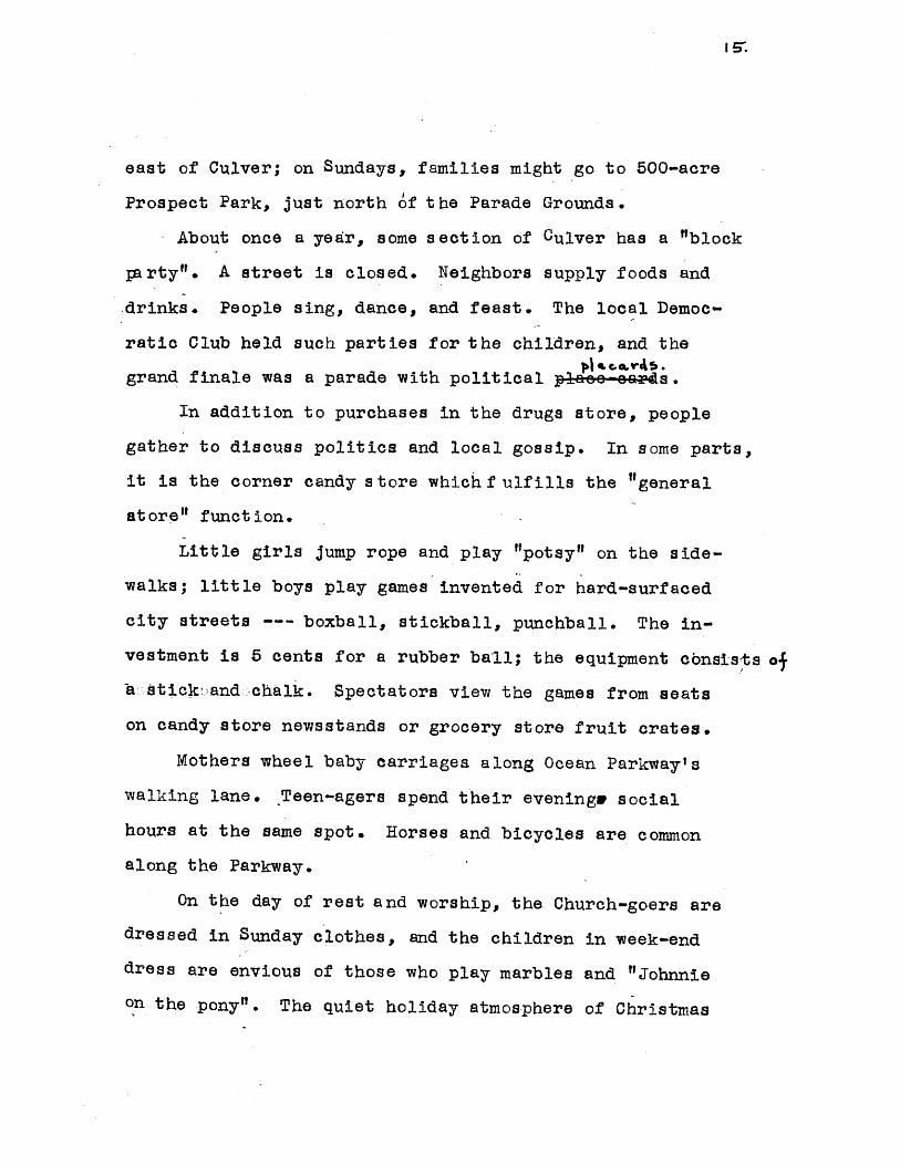
About once a year, some section of Culver has a "block
p;arty". A street is closed. Neighbors supply foods and
drinks. People sing, dance, and feast. The local Democ-
ratic Club held such parties for the children, and the
grand finale was a parade with political pee-e4a4s.
In addition to purchases in the drugs store, people
gather to discuss politics and local gossip. In some parts,
it is the corner candy store whichf ulfills the "general
atore" function.
Little girls jump rope and play "potsy" on the side-
walks; little boys play games invented for hard-surfaced
city streets --- boxball, stickball, punchball. The in-
vestment is 5 cents for a rubber ball; the equipment consists o
~asatick.and chalk. Spectators view the games from seats
on candy store newsstands or grocery store fruit crates.
Mothers wheel baby carriages along Ocean Parkway's
walking lane. Teen-agers spend their evening& social
hours at the same spot. Horses and bicycles are common
along the Parkway.
On the day of rest and worship, the Church-goers are
dressed in Sunday clothes, and the children in week-end
dress are envious of those who play marbles and "Johnnie
on the pony". The quiet holiday atmosphere of Christmas

16.
and Baster, of Rosh Hashonah and Yom Kippur; the humid
summer days, when sidewalks steam and the fire depart-
ment employees allow children to g et under t he cool fire
hose; the seven-fifteen p.m. rush of boys fromt heir homes
onto the streets.to discuss the local baseball game,
the result of which has just been announced; the summer
exodus to the Castskill mountains and the beaches along
the Atlantic ecast; the Saturday night subway trip to
Manhattan or downtown Brooklyn to see the latest Holly-
wood production; the summer evening open-air, free Gold-
man concerts in Prospect Park-o the millions of passenger
fares collected on the transit stations within Culver,
and the subway riders w ho spill over to Manhattants
downtown for daytime occupations--all of t hese ingre-
dients whipped together make Culver.

7.,
POPULATION PREDICT ION
Population predictions for a community are difficut
because of many limiting factors, particularly the lack
of past inter-oommunity migration studies and the absence
of borough, city, and regional analyses of population
movement. Borough and urban trends are important in the
consideration of any segment of the whole, since regional
trends are more indicative of basic changssAn the popu-
lation pattern and the community is only part of a wider
economic base which affects sharply both the totality
and the specific smaller area. We, therefore, make cer-
tain assumptions both in our predictions and in the use
of forecast figures:
(A) The cardinal premise is that short-term predic-
tions are the most functional for approaching any degree
of accuracy, while long-term forecasts are vital for the
"implications" demonstrating future trends in the charac-
teristics of the population.(5) "In a dynamic world, forces
in operation are seldom allowed to work themselves out be-
fore other factors make themselves felt. Consequently,
any type of mathematical trend may 'work' only for a re-
latively short period."(6)
(5) National Resources Planning Board, Estimatesof Future Population Of The U.S. 1940-p. 36.
(6) Frederick Croxton and budley Cowden AppliedGeneral Statistics, (New York, 1941, .p. 462

Ia.
(B) Whatever the estimates be, the planning agency must
be flexible both in design and execution of proposals so
that variations in the actual populations vis-a-vis esti-
mated population, due to unfore-seen factors or error of
judgment, can be absorbed.
(C) The 12-year rebuilding or rehabilitation plan presen-
ted for Culver has been considered a short-range scheme,
to be executed by 1960. Since it is necessary to discover
future population as the basis for any planning, we must
ferret out the reasonable factors within the community,
predominantly, building activity, birth and death rates,
and family size and develop some logical pattern for reach-
ing conclusions. In making plans, private or public, for
the future development of an urban area, region or com-
munity future population must serve as the basis, for the
"lesaence of planning" is to estimate the total numbers
and distribution of age groups which will reside in a
given space and then to provide the necessary facilities
and services needed. (7)
(D) No long-range community plan seems adequate without
initial or at least concurrent regional planning. Since
the future population of an area depends upon a combina-
tion of regional economic factors, aspects of suburban
(7) Regional Plan Association, Inc., The EconomicStatus Of the New York Metropolitan in 1944,(NeW York, 194-4) p.1.

i.
magnetism, inter- community migration, future public policies
in regard to the land, and historicale dynamics, other com-
munities must be studied in relation to Culver so that inter-
community trends can be analyzed and a system of priorities
and allocations established in order that that "first things
come firsts Thus a wider area must be considered in terms
of long-term influence upon any specific urban unit before
forecasts for that unit can have definitely meaning or be
properly acted upon. Since such a study would entail un-
due research, it had to be excluded in determining Culver's
population.*
(E) It is realized that economics, although more signifi-
canthmere-excess of births over deaths in population deteri
mination (8), cannot,therefore, be an operational base for
estimating future population of an individual community.
The less satisfactory method had to be used: for a short-
range forecast , however, it might prove adequate.
(F) For birth and death rates, survival ratios, fertility
rates, and distribution of the age structure, city and
borough trends were evaluated and projected into the future.
Thus, for example, those between the ages of 5 and 14 formed
15% of the total Brooklyn population in 1930; in 1940,
this age - group decreased numerically and proportionately to
12% of the total. In contrast, the older age groups
showed gains in that period. The use of past tendencies in
(8) Regional Plan Association, Inc., Op. Cit.,
p. 2.

20.
the other factors related to population prediction seems
reasonable, unless of course radical, indeterminable de-
viations occur because of increased living standards, ad-
vances in medical science and public health, etc..
Since we have in Culver a mere segment of a whole, we
had to arrive at future population by some working method.
We know the present population, and available vacant land
suitable for building, and we can estimate future births
and deaths, family size and age distribution. Without as-
certaining a migration factor, we assume that once popu-
lation and available dwelling units have been projected,
those who cannot be housed will move elsewhere.
Given the population of Culver in 1940, we can emp-
loy a simple formula P45 equals P40 plus 5(b-d), where P4 5is the population in 1945; P4 0, the 1940 population; 5 is
a 5-year interval; and b and d are the number of annual
births and deaths. Of the existing 22.5 acres of vacant
lands in the area, only 10 acres are estimated as practical
sites for residential construction. Those lots considered
unsuitable for house construction are located under eleva-
ted lines or along a railroad cut. The fact that only 10
acres are potential residential sites limits the net is-
migration after 1945 to 2,000 people, or employing 3.7 per-
Sons per family as the average household size, an absolute

21.
increase of 405 dwelling units from 1945 to 1950. This
conclusion is based partly on the assumption that demo-
lition of dwellings will be a negligible factor, since
between 1940 and 1945 only 10 units were abolished des-
pite some 350 units over 40 years.of age. However, from
1950 to 1960, it is probable that with 350 units over 60
years of age, and about 9,50C units over 30 years old,
there will probably be increased demolition activity over
and above new construction, unless the neighborhood environ-
ment is amended for the better, or local sentiment be so
powerful as'to retain families in the section. Following
is a num'erical picture of how future population was cal-
culated:
BIRTH AND DEATH RATES (9)
Births/1,000 Year
35.0 190028.5 191923.5 192017.5 193014.8 194014.0 1940-194520.0 1945-195012.5 1950-195512.0 1955-196011.0 1960-196510.0 1965-1970
(9) Statistics from the NewDepartment.
Deaths/l,000
200616.013.511.210.5100210.010.010.010.010.0
York City Health

POPULAT ION FORECAST
Year- Increase of Births over Deaths Potential Population
1940 ---- 95, 1671940-45 1900 97, 0671945-50* 4850 101, 9171950-55 1276 103, 1921955-60 615 103, 807
Year Population In New Dwelling Units Increase Pot. Pop.
1940-45 7504 (10) 265 7, 7691945-50 9769 490 10, 2591950-55 10259 ' 125 10, 3841955-60 10384. 105 10, 489
TOTAL POTENTIAL POPULATION IN L960 (11)...124,298 .
* Post-war birth rate estimated at 20/1,000. A slowing downand eventual return to the downward curve is foreseen.
However, since the number of housing units would be:
25, 715 Dwelling Units 1940
1, 500 1940-45405 1945-50
27, 620 Total D.U..19501, 363 5% Vacancy
26, 257 Total Occupied D.U. 1960
With 3.4 persons per average family, the actual popu-
lation housed would amount to: 89, 273.
Thus, a migration from Culver would total: 35,025 1940-1960.
Thus, predicated population for 1960 is: 89,273, or a
5, 894 decrease (6%) from 1940. This is a 5% increase over
1930's population of 85, 003.
(10) 8% increase in the number of families adaptedfrom the 1945 N.Y. Times Census.
-(11) Potential population is the number which wouldnaturally accrue from the birthndeath difference.

Year
1900
1910
1920
1930
1940
1950
1960
1970
23.
Number
4.6
4.6
4.4
4.0
3.8
3.6
3.4
3.2
In determining the distribution of population by
age-groups, survival ratios and birth rates were employed.
For 1950, the 1940 population was projected via survival
ratios. The 1960 percentage distribution was calculated
from a survival projection of the 1950 population; how-
ever, since we calculated the total population for 1960
above, we accepted that figure and merely applied the
1960 percentage distribution adjusted to N.R.P.B esti-
mates for U.S. population, in order to arrive at the age
structure.
ONRPP, O p. 132, Table 20.
Average Persons Per Famil
24.
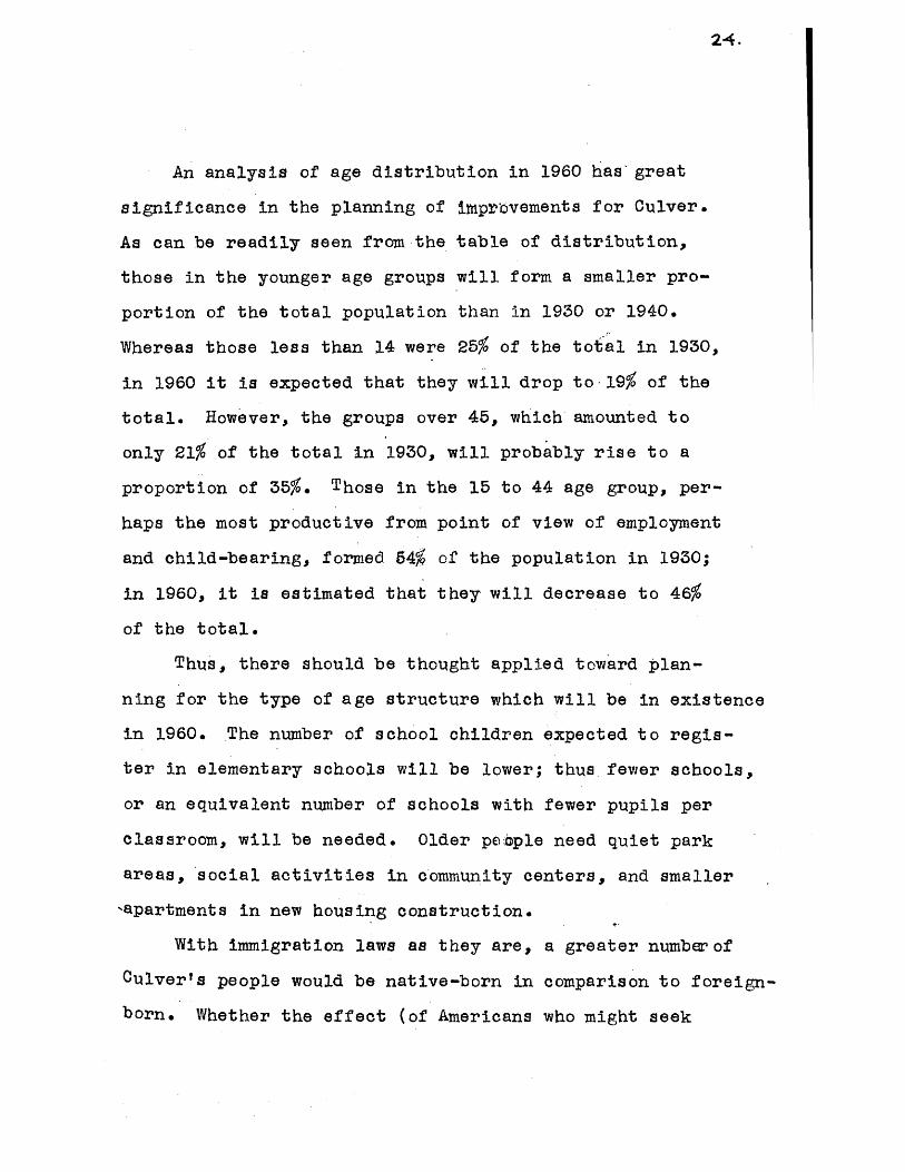
An analysis of age distribution in 1960 has great
significance in the planning of imprbvements for Culver.
As can be readily seen from the table of distribution,
those in the younger age groups will form a smaller pro-
portion of the total population than in 1930 or 1940.
Whereas those less than 14 were 25% of the total in 1930,
in 1960 it is expected that they will drop to -19% of the
total. However, the groups over 45, which amounted to
only 21% of the total in 1930, will probably rise to a
proportion of 35%. Those in the 15 to 44 age group, per-
haps the most productive from point of view of employment
and child-bearing, formed 54% of the population in 1930;
in 1960, it is estimated that they will decrease to 46%
of the total.
Thus, there should be thought applied toward plan-
ning for the type of age structure which will be in existence
in 1960. The number of school children expected to regis-
ter in elementary schools will be lower; thus fewer schools,
or an equivalent number of schools with fewer pupils per
classroom, will be needed. Older people need quiet park
areas, social activities in community centers, and smaller
,apartments in new housing construction.
With immigration laws as they are, a greater numberof
Culver's people would be native-born in comparison to foreign-
born. Whether the effect (of Americans who might seek

25-
better living quarters in the suburbs) would be an exodus
from an older Culver community is difficult to answer,
but worth considering.
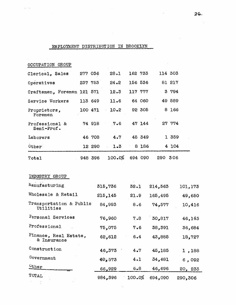
Although further studyrnecessarily have to be ap-
plied before Culver's distribution of occupations and in-
dustries could be ascertained, the accompanying table on
page2G gives Brooklynts range of employment. It may be
assumed that Culver has approximately the pattern shown
for the borough. However, rather than translate the pat-
tern, which could not be accurate, we offer it as a clue
to Culver's employment source. Over 50% work in Manufac-
turing, wholesale, and retail industries. Over 50% are.
in clerical or operative occupations.
2G.
EMPLOYMENT DISTRIBTJTION IN BROOKLYN
OCCUPATION GROUP
Clerical, Sales 277 036 28.1 162 733 114 303
Operatives 237 753 24.2 156 536 81 217
Craftsmen, Foremen 121 571 12.3 117 777 3 794
Service Workers 113 649 11.6 64 060 49 589
Proprietors, 100 471 10.2 92 305 8 166Foremen
Professional & 74 918 7.6 47 144 27 774Semi-Prof.
Laborers 46 708 4.7 45 349 1 359
Other 12 290 1.3 8 186 4 104
Total 948 396 100.0% 694 090 290 306
INDUSTRY GROUP
Manufacturing 315,736 32.1 214,563 101,173
Wholesale & Retail 215,145 21.9 165,495 49,650
Transportation & Public 84,993 8.6 74,577 10,416Utilities
Personal Services 76,960 7.8 30,817 46,143
Professional 75,075 7.6 38,391 36,684
Finance, Real Estate, 62,612 6.4 43,885 18,727& Insurance
Construction 46,373 4.7 45,185 1 ,188Government 40,573 4.1 34,481 6 , 092
.0ther _66,929 6.8 46,696 20, 233
TOTAL OQA 'Z a I nn nP . , 29* ,306
21.
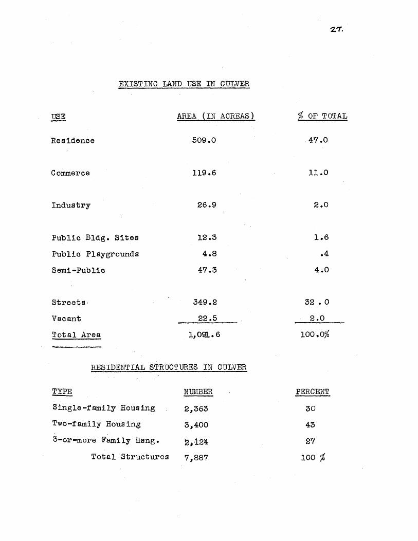
EXISTING LAND USE IN CULVER
AREA (IN ACREAS) % OF TOTAL
Residence
Commerce
Industry
Public Bldg. Sites
Public Playgrounds
Semi-Public
Streets-
Vacant.
Total Area
RESIDENTIAL STRUCTURES IN CULVER
TYPE
Single-family Hous ing
Two-family Hous ing
3 -or-more Family Hang.
Total Structures
509.0 47.0
119.6 11.0
26.9 2.0
12.3
4.8
1.6
47.3
.4
4.0
349.2
22.5
32 .0
1,091.6
2.0
100.0%
NUMBER
2,363
3,400
2,124
7,887
PERCENT
30
43
27
100 %

28.
LAND USE:
Land use in Culver is characterized by an excessive
ratio of gridiron streets and elongated commercial fron-
tage, an utter lack of community cultural, social, and rec.t red+rona
space, antiquated school plants, land crowding, and in-
congruous land uses. There are blighted areas paral-
leling elevated lines and surrounding commercial zones.
RESIDENCE:
Culver can be considered as one of the "bedrooms"
of Manhattan, for many of Manhattant's workers reside
there. Residential land accounts for 49% of Culverts
1,091 acresi. About 23 acres, or 2% are in vacant lots.
In 1940, (19 of the area's 26,000 dwelling units, 78%
were tenant-occupied; 17%, owner-occupied; and 5%, vac-
ant or for sale. Of the 8,000 residential structures,
43% were in two-family housing530%, single-family homes;
and 27%, 3-or-more-family apartments. Along Ocean Park-
way, there is practically a solid line of high rental,
modern 6-story apartments. The homogeneous area along
15th,16th and 17th Avenues contains good single and two-
fariily housing. Desirable homes are located in the area
surrounded by 18th Church, Ocean, and McDonald. The most
recent development of homes has occurred South of bt.
Hamilton Parkway and West of McDonald.
(12) Bureau of the Census, Census of Housing,(1940)
A very common category of residence in Brooklyn is
the multi-family housing above stores. These are parti-
cularly noticeable in Culver, where almost without excep-
tion every commercial establishment possesses 2 or 3 higher
floors of residential use. Along New Utrecht and McDonald
Avenues, hosts of fanilies live above stores within the
shadows of elevated transit lines. Unfortunately, census
tract or block statistics do not portray the true charac-
ter of erosion prevalent in these districts. The real
darkness, dull housing, and grey atmosphere have been mase
querading in optimistic costume under the census housing
figures.
There is not alone incoherent use of land side by
side, as in some cases wherein a single-family house,
an apartment building, a garage, and a dry cleaning plant
share the land as neighbors, but within one structure
there may be a number of unrelated, inharmonious uses.
In business areas, a single unit may consist of a retail
outlet, a second story of offices or storage, and a third
and/or fourth floor for living.
That Culver's dense settlement is relatively recent
is borne.out by the age of dwellings. Thirty-five per-
cent of the units were constructed from 1920-1929. (Thirty-

30.
five percent of the units were constructed from 1920-
1929.) While the borough of Brooklyn had 10%, Culver
had 17% built in the decade between 1930 and 1940.
Another 46% were developed between 1!900 and 1919; only
some 350 units, or 2%, date from 1899 or before, while
in the entire borough, X of the dwellings were built
prior to 1899. It might be noted that although over 50%
of the housing units are less than 27 years of age, the
average age of schools is 35. Thus, housing enveloped
school areas, with an attendant result of covering over
open spaces, sans forethought of consequences.
Perhaps the greatest barrier to a general pick-up
in depressed areas is the elevated structure. Along these
rights-of-way exist the worst housing, and vacant and
marginal commercial buildings.
Another deterrent a general revival of depressed
sections is the spread of business frontage given impe-
tus by zoning. The zoning regulations condone ribbon de-
velopment of business along avenues. The areas surroun-
ding businesa centers have slowly deteriorated. For ex-
ample, 13th Avenue, which some 15 years ago was compara-
tively unrecognized as a magnetic shopping street, is
today one of the most thriving in the borough. Parado-
xically, as 13th Avenue developed in attraction and wealth

31.
and as older stores assumed more modern facades, the
comnercial crescendo drowned out the continuous drone
of blight on all of the immediate interior streets lead-
ing into the Avenue. Increased congestion of automobiles,
multitudes of shoppers, bus lines, and occasional move-
ment of business into the side streets contributed to
the process. Here again, census figures curtain the
scene. One becomes convinced by looking at-the site,
by watching the evolution over a period of time, that a
house by house survey would show the actual conditions.
Still another phenomenon which is perhaps more
subtle than factors mentioned is a borough-wide spread
of blight which is strikingly evident from census figures
on housing conditions, population losses from 1930 to 1940,
and rentals. The low, rentals, population de creasing, and
poor housing conditions superimposed on a borough map
show a definite pattern of overlapping; moreover, they
thrc-w into bold relief a snowball of blight which is gather-
ing momentum and gaining territory. The origin is in
ncrthern Brooklyn. The path of blight is varied, with
pincer-like wedges pushing into the Culver area from the
west, south of Greenwood Cemetery. Such a boroug4 pic-
ture might have been studied in somewhat more detail.

32.
CIRCUIATI ON
Culver's muddled street system is the result of a
series of successive unplanned subdivisions. .Thus, when
streets terminate in one subdivision, they fail to mesh
with any street in an adjacent area, making for a jagged
pattern. Adding to the ineffie enChgf, streets account
for an unproportionate 32% of the total land area.-Streets
have over 100,000 linear feet en toto. There is no sense
of system, with practically all east-west streets contain-
ing 100-foot rights of way. There has been no effort to
conserve residential areas by limiting through traffic
and by some type of belt circulation. The philosophy of
the belt is pursued by the city for Brooklyn, with a Belt
Expressway, but not for col nunities.
Ocean Parkway , with a 200-foot right of w ay, is the
main artery carrying the load of autoists to Manhattan
or southward to the Belt Parkway system. In 1940, it
was suggested that since it has adequate width and is in
a strategic location Ocean Parkway should be converted
into a limited access express-way. (13) With the opening
of theeBrooklyn-Baite'p"Tunnel to Manhattan, and the
proposed culmination of a genuine belt system connecting
the East River Bridges with the Belt Parkway, another
link is needed across the Borough of Brooklyn.
(13) Mayor's Committee on City Planning,City Wide Studies, project #117.
33.
Mass Transportation: Culver is a subway-using
community. The West End transit line runs over New Ut-
recht Avenue. The Culver elevated operates above Mc-
Donald Avenue, cutting across 37th Street. Eventually,
both lines reach Coney Island at the Southern end, and
stretch into Manhattan's subway network at the northern
end.
The Independent Subway Line, which terminates at
Church and McDonald Avenues, will soon operate over a
connecting ramp along McDonald Avenue between Cortel-
you oad and Avenue C, thus intertwining the Independent
and B.M.T. systems. Since some $20,000,000 has been
earmarked by the Boafd of Transportat ion (14) for the con-
nection, and for rehabilitation of the Culver Line, it
is safe to assume that the elevated is fixed for some
years to come.
As evidence of the importance of subway travel in
Culver and vicinity station fare collections can be ta-
bulated. In 1946, the number of passenger annual fares
collected at all Culver stations amounted to over 19
million. Assuming a 6-day work week, this 62,000 persons
use eleven transit stations daily. This is in addition
to the figures (which could not be calculated from to-
tals for entire lines) for all bus and trolley lines which
cut across the area and connect with all parts of Brooklyn.
(1I) New York City Planning Commission,1947_Capital Budget.
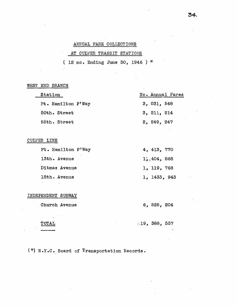
ANNUAL FARE COLLECTIONS
AT CULVER TRANSIT STATIONS
12 mo. Ending June 30, 1946 ) *
WEST END BRANCH
Station
Ft . Hamilt on P' Way
50th. Street
55th. Street
No. Annual Fares
3, 031, 548
3, 211, 214
2, 249, 247
CULVER LINE
Ft. Hamilton P'Way
13th. Avenue
Ditmas Avenue
18th. Avenue
4, 413, 770
1,44, 868
1, 119, 768
1, 1433, 943
INDEPENDENT SUBWAY
Church Avenue 6, 525, 204
TOTAL *.19, 388, 557
(*) N.Y.C. Board of Transportation Records.

35-.
Railroad: Bordering G;ulver on the South is the
depressed L.I.R.R. trackage, with auto overpasses trn!-
versing the cut at all street inter-sections. A freight
line which runs from Brooklyn's coast on the West to
Coney Island used the McDonald trolley tracks. These
tracks lie on the street surface, below the Culver tran-
sit. Since the freight line plays a minor role in ser-
vicing Culver's industrial section, and since the run
is made only three times daily, it is conceivable that
the line could be stopped. Trucks could service the
fruit produce markets. If someday, also, the trolley
line along McDonald could be ended, supplanted by a bus
route along Ocean Parkway, then McDonald Avenue would b e-
come a local street without hindering trackage. A more
adequate neighborhood unit, with P.S. 134 as the nuc-
leus, and witaout a major crossing for school children,-
would be effected.
COMMERCE.
Business use is 11% of the total -land area. Along
New Utrecht and McDonald Avenues, vacant and marg:inal
stores abound. A walk along either of these streets,
under the Elevated, would bring this condition into
dramatic focus. Both ends of 13th Avenue, from appro-
ximately 50th Street westwards and from 39th Street east-
warss, are depressed commercial areas. Blighted business

36.
areas are found within interior streets and near indus-
trial sites.
Shopping is strung out along 18th Ave., Ditmas,
and Church Avenues. It is spotty along almost every
other avenue. In recent years, 13th Avenue has as-
cended into the dominant shopping position of Culver
and surrounding communities. Despite the fact that
Manhattan, and other Brooklyn shopping nuclei attract
Culverites--Dept. Store areas particularly--still a
huge volume of business is done on 13th Avenue. With
an efficient, planned arrangement of shops in a real
center, with provision for adequate off-street parking,
and with the addition of some much-needed amusement fa-
cilities, such as a movie theater, bowling alleys, etc.,
13th Avenue would attract an even greater trade--if even
for the novelty -of a planned shoping center in Brooklyn.
PUBLIC IAND
Bellides the 9 schoole- in the area, Culver contains
a Police Station on Lawrence Avenue, near Ocean Parkway;
a Fire Station on Foster Avenue near McDonald. Rented
stores house 2 public libraries, one on McDonald near
the Ditmas Avenue transit stop, the other on 13th Avenue
off 52nd Street.
37.
A new 66th Precinct Police Station has ben. sugges-
ted by the Capital program of the New York City Plan-
ning Commission; the site is yet unselected.
A new library will be constructed to replace the
existing one on 13th-Avenue; the site, not yet chosen,
is suggested for the same general vininity.
Perhaps wherever efficient and/or desireable,
public buildings could be grouped into one pleasant
center.
SEMI -UBLIC IAND
Culver's 47 acres of semi-public, tax-exempt land
contain churches and synagogues, a Doctor's Hospital on
15th Avenue, a Hebrew College 6n 13th Avenue and 50th
Street, and a Parochial College in the northeasterncor-
ner of Fort Hamilton Parkway.
Some of the synagogues, notably one on Ocean Park-
way and Ditmas and, one at Ocean and Church, and a few
of the churches have indoor recreation facilities and
community center activities. Although these are private,
they should be considered in any comprehensive plan of
indoor community recreation.

38.
INDUSTRY
Accounting for 216 of the total land, industry is
rather compact, grouped from 37th to 39th Streets, north
of 13th Avenue. Except for loft building storage, and
some coal yards, the significant light industry is
fruit and grocery produce. The foods are hauled predo-
minatly by truck, and redistributed to retail stores .in
the area. Although there is some freight transportation,
which unloads on a railroad siding, this method is in-
signif-icant.
There are some cases where industry mingles with
residence to the detriment of both land uses.
LIBRARY
The New York City Planning Commission has recom-
mended two new libraries to replace the existing inade-
quate rented stores in the general areas where they are
now located. (14) The following charts taken from the
study show the inadequacy of the facilities and plant.
Both the Kensington and Boro Park Branches serve more
than just Culver. If only a limited number are t o be
served, perhaps the Boro Park branch might be built in
Culver, with the one proposed for Kensington in another
community.
(14) New York City Planning Commissions, ProgramFor The Ftblic Libraries of New York-City,(1945).
23 .
EDUCATION AND RECREAT ION
The inadequacy of the New-York City education sys-
tem to meet modern objectives will not be treated; the
Public Education Association in a joint study with the
New York State Educational Conference Board issued an
extensive report on aJmost every phase of education in
New York City (15). In this section, we are interested
in showing trends in enrollment, the status of physical
plants, and the amouiat of recreation area which Culver
possess.
The philosophy which underlies the school planning
program has been borrowed from Henry Cohen who, in his
study of school-community relationships, attaches three
vital functions to the school (36):
(a) Education for the "complete child": Culture,
supervised play, and health are school responsibilities.
For example, a school lunch program has been instituted
recognizing that nutrition is an important part of a
child's development, but the need for modern lunch-rooms
as a functional unit of the school plant has been over-
looked.
(b) Adult Edudation Center: In 1943, when the W.P.A.
adult education program ended, only 4% of the Brooklyn
schools had such programs. There is need for a wider use
(15) The New York State Educational ConferenceBoard and the Public Education Associationof New York City, Fiscal Policy For PublicEducation In The State Of New York, 194'7
(16) Henry Cohen, A Study Of School-CommunityRelationships ~In Brooklyn, New York,
(Brooklyn Council for Social Planning), 1944.

+
of the schools for instruction in cultural and vocational
subjects, child care and psychology, and consumer edu-
cation.
(c) Community Activities Center: The teacher must
know the child's social and economic environment, and
the family must have closer contact with the teacher
and the school's activities. Such an arrangement would
stimulate fuller understanding.
A fourth category might be added: "Decentraliza-
tion" of the school system into community divisions "tbr
more manageable units" (17)
Average Attendance In Culver's Schools:
There is not one public school in Culver which ex-
hibits a rise in attendance. From 1930 to 1945, there
was a decline of 35% in the number of children attending
elementary schools, and a drop of 26% in those attending
the Junior High from 1935-1945. Despite the fact that
the population of Culver increased 12% from 1930 to
1940, the downward trend in school enrollment continued.
Although the average school plant was designed to contain
approximately 45 pupils per classroom, the present ave-
rage is 25.
The decline in school population is evident through-
out New York City. New York reached a peak of 820,000
elementary and 'junior high pupils in 1931, and declined
(17) Benjamin Fine, "Education in Review",New York Times. (December .4, 1947)
41,
33% to 1945. Manhattan dropped 60% from 1920 to 1945,
and Brooklyn 18% in the same period. In the Northern
Part of Brooklyn, dozens of schools were abandoned when
industry invaded residential areas, and the latter lost
population and deteriorated. (IB) In Brooklyn there are
11,000 classrooms with 450,000 sittings, yet only 200,
000 pupils are enrolled. Thus average classrooms de-
signed for 40 pupils contain 18, an average tf 2 seats
for every child.
Age in Years1947 1960
Facilities Point Score Age-FacilitiesIndex
P.S. 103
P.S.
P.S.
P.S.
P.S.
P.S.
P.S.
P.S.
J.H.S.
(18) Information gathered inEducation officials.
conversation with Bd. of
School
51
46
46
37
32
22
23
17
17
64
59
59
50
45
35
35
30
30
5.0
4.0
3.1
6.9
7.0
7.0
9.3
1001
37.0
.09
.09
.07
.18
.22
.32
.40
.59
2.18

4.
School Plants and Recreation:
The average and median year of construction of all
Culver schools is 1912. One was built 1896; 2 in 1901;
1 in 1910; and only 2 were constructed as late as 1930.
Although a weight-system for facilities doesn't indicate
size or adequacy of gymnasiums, auditoriums, and special
rooms, it does give a comparative picture of facilities.
The basis of a "facilities point score" is as follows:
playground, 3 points/acre; 1 auditorium, 2 points; 1
library, 2 points; 1 gynmnasium, 2 points; 1 lunchroom,
2 points; an assembly room, 1 point; 1 special room, 1
shop, 1 laboratory, 1 point each. A minimum "facilities
point score", which contains 1 of each and 8--acre play-
ground (19) would total 35. Despite the high score of
J.H.S. 223, it contains only 1 acre of playground, It
would need 8 times that amount to serve a neighborhood
population of 15,000, using a minimum standard of 1 acre
1,750 people.
Of the total number of .9 schools, 4 have no play-
grounds.whatsoever, while the 5 which have open space
contain a combined total of 3.8 acres to serve the com-
munity of 95,000 people; 6 have no assembly rooms; 2
have no auditoriums; 5 have no libraries; 6 have no
special rooms or labs or shops; 1 haar no ginnasium of
any type.
(19') F. Dodd McHugh, Cost Of Public Services InResidential Areas, (New York, 1942), p. 1414.

45.
There is no High School to serve the area. Students
of high school age travel by mass transportation to at-
tend schools in other parts of the borough. Scme walk
to Midwood and New Utrecht High Schools which are over
a mile from Culver's boundaries. It is estimated that
there are some 3,800 high school pupils who go outside
of the area for their education. Assuming that appro-
ximately 15-20% of these would attend special vocationl,
trade, and prep schools, 3,000 could be attending a High
School within the area.
It is true that 525 acres of park are located with-
in walking distance of northeastern Culver residents.
In addition, there are some 40 acres of active recreation
space just south of Prospect Park. Ocean Parkway has a
apecial lane for bicycles, a wide bridle path, and a strip
of tree-lined sidewalk for beneb:.-sitters and strollers.
However, the Culver community contains only 4.8 acres
of local playgrounds. Compare this very low amount with
requirements. According to many standards, local play-
grounds, playfields, and parks should take up approxima-
tely 3-5 acres per 1,000 population served; in a commu-
nity with about 100,000pulation, this would mean a mi-.30o ac-es 0i
nimum ofAopen recreation and park. In addition to stan-
dards of acreage per population, there have been ideas

4*.
on how large a minimum playfield or playground should
be, and the effective radii of these areas to serve
a given population. (20).
Culver missed't he opportunity to retain open
spaces before the regrettable land crowding. In the
middle of the 19th Centuryneighborhoods" were sugges-
ted by landscape architects. (21) In 1916, The City Club
of N.Y. issued an unheeded plea that "if we are to
have- residential districts within our crowded cities,
we must have recreation space". (22) The Bvwiham plan
for Brooklyn recommended a comprehensive development
of parks, athletic fields, and school playgrounds"
(23) in the Culver vicinity.
In a built-up urban area, standards seem diffi-
cult to follow. They should, however, be used as yard-
sticks when thorough studies are made in regard to a
long-range recreation plan for the community. In this
study, the short-range attitude is to locate new play-
grounds adjacent to schools, a policy being started on
a larger, scale by the Board of Education in conjunc-
tion with the Park Department, with an approximate stan-
dard size of 5 acres. Wherever possible, land costs
are taken into consideration, and existing vacant lots
(20) National Recreation Association, Chicago PlanCommission, Cambridge City Planning Board andKansas City Planning Commission have prettywell agreed on Minimum Standards.
(21) Olmstead, Vaux & Co. Observations On the ProgressOf Iiprovements In 'treet klans (Brooklyn 1868.

and public streets woven into the system where feasible.
It should be recognized that large parks are ne-
cessary for borough-wide use. Here, picnic grounds,
concert malls, dance pavillidns, lake recreation, and
generally larger activities, take place. However, the
neighborhood park, and the local playground, within reason-
able walking distance of home, which people, particu-
larly children, can reach without crossing dangerous
roads, without travel via subway or streetcar, are valua
able community assets. Thus, although huge amounts of
capital expenditures might be warranted for expansive
Marine Park or Dyker Park in Brooklyn, it seems that lo-
cal play areas should receive the attention it deserves
and lacks in Culver.
(22) The City Club of N.Y.C., A Plea For ThePreservation Of Our Small Parks As "eigh-bors Centers, (N.Y. 1916) p. 3.
(23) Brooklyn baily ag le Brooklyn City Plan(January 18, 1914), map.

4G.
CITIZEN SUPPORT FOR COMMUNITY PLANNING.
The value of community organization for citizen
participation in plans and for securing city funds for
local improvements will not be assessed. Public sup-
port of planning is a recognized tenet among many City-
Planners. The following is a method for organizing
Culver's groups into a Community Council for Planning
Action.
In 1911, Reverend Dr. Newell Dwight Hollis became
intensely interested in the consequences of crowded
urban living. He delivered a series of addresses in Ply-
mouth Church up in Brooklyn Heights, and received much
newspaper support. Reverend Hollis spoke of a "city
useful" and a "city convenient", of regional planning
for all of Brooklyn, Queens, and Long Island, and of
halting the suburban exodus. (24) Ie stated that "only
apoplexy and Greenwood Cemetery"' would cure the short-
sightedness of our public officials. (25) The Reverend's
pleas bore fruit, for in 1912 Borough President Alfred
E. Steers appointed a citizen group, called the "Brooklyn
Committee On The City Plan." The Committee acted im-
mediately: the illustrious Daniel H. Burnham was in-
vited to study Brooklyn and recommend a comprehensive
plant "to cope with and control an orderly development
of the borough". (26)
(24) "Planning to Make Brooklyn A City Beautiful,"New York Times, February 4, 1912.
(25) Brooklyn Daily Eagle, Brooklyn City Plan,(January 18, 1914, P.4.
(26) Ibid., p. 3

4-7.
Thus in addition to foresight ere urbanization
became an entrenched phenomenon, and proposals many
of which have been carried out since and many of which
are progressive even for tcday, we have a precedent
for active public participation, participation given
government approval and aid.
Since that time, there have been setbacks. In
1930, the Borough President vehemently opposed the
creation of a City Planning Board. A Brooklyn Borough
Advisory Planning Boafd was created under the 1938
Charter (2) but failed to function effectively. Since
then, however, there have been signs of activity. The
fact that citizens turn out to vote on issues which
they regard as important proves that objectiveS must be
crystallized by publicity in order that people act to-
gether. When the people of Culver were not satisfied.
with the waterr supply of a private water corporation,
they exerted pressure on their representatives for muni-
cipal water, and the old water system was replaced. The
Brooklyn Council for Social Planning has recently or-
ganized local autonomous civic councils for 8 Brooklyn
neighborhoods; however, there is none in Culver.
(26) New York City Charter, (1938), Chapter 8,Section 196.

48.
A local community council similar to the "Committee"
of 1912 is needed for Culver to make plans and to make
plans felt by act'ion. Such an organization would operate
if 5 factors were met:
(a) The existence of a physical community.
(b) A place to hold meetings and house thework of the organization,
(4) A nucleus of associations within the com-munity
(d) Government approval and cooperation.
(e) Publicity.
(a) The physical community has been discussed in
preceding chapters, and it is now assumed that it exists.
(b) The present schools which are tobe abandoned
as educational units will be converted into civic centers,
and any one of these buildings could serve as a meeting
hall and center of operations for the organization.
(d) By official sanction, we mean that the Borough
President through his Advisory Planning Board must re-
cognize and aid the Culver Council. The New York City
Planning Commission must also receive the suggestions
of the Council, and offer its technical assistance.
The Department of Community Education of The Board of
Education must play a vital role in public education
and community center organization.
(d) Within the Culver community, a wide base of
organizations exists. These could be represented in
the Council.
49.
Religious: Protestant, like the Prospect Park Babtist,
Parkville Congregational-Christian, and
Ascension Lutheran Churches.
Jewish, like the Temple Bethel, Temple Ema-
nuel, and Young Israel Synagogue of Boro Park.
Catholic, like the Holy Ghost.
Veterans: Local Chapter of the American Veterans Com-
mittee,
Educational: Local Parent-Teachers Associatations in
each school.
Business: 13th Avenue Merchants Association.
Social Agencies: Y.M.C.A. and Y.M.H.A; Jewish Welfare
Society; various church groups like the Jewish
Community Center of the Hebrew Institute.
Civic: LKensington Civic League; Parkville Improvement
League; West Midwood Community Association;
Boro Park Civic Club; Mapleton Civic League;
etc.
Some attempt should be made to represent those people
who are not part of any organized group. This might be
accomplished by open meeting voting, and by volunteer
workers for surveys and investigations.
Borough-wide groups could act as sources of advice
and inf ormation:

5o.
Veterans: A.V.C.; American Legion; V.F.W.; Catholic
War Vets. All have offices in Borough Hall.
Religious: Catholic Youth Organization; Church Mission
Federation; Jewish Communit Council.
Labor: Borough Branch of the C.I.0.
Bus inss: Flatbush Chamber of Conmerce: Flatbush Mer-
chant Association; Flatbush Taxpayers As-
sociation.
Education: Parent-Teachers Association. Teachers? Union.
(e) 'By publicity, we mean both preparatory and post
organization drives. Thus the community must be prepared
for a Planning Council, and this signifies education in plan-
ning. The Brooklyn Council for Social Planning is perhaps
the most active in local affairs. Although its function is
primarily social service, it could be expanded to include
the stimulation of planning interest and planning organiza-
tion. In Mr. George C. Cheever, secretafy of the Committee
on Neighborhood Organization; the B.C.S.P. has a man in-
terested in city planning, and well-acquainted with com-
munity organization. Leadership and publicity could come
from the Brooklyn Daily Eagle, a borough newspaper which
has always been alive to principle, of city planning.
Brooklyn college, which is nearby, could be a very fine
source of leadership and community counsel. The Colleges
Sociology and Economics Departments could also offer aid
in community studies and plans.
911.
However, most of the organizatgig and education must
come from the base, the community itself. Thus, the schools
must educate the pupil, who in turn educ ates his parents.
The present pupil becomes tomorrow's community planning
participant, and the more he knows. -the more effective the
future organization. The schodil can serve as center for
exhibits of both childrents and Culver Councilts ideas
for development. The school could give adult education
courses, withe xperts invited to lecture. The community
center could also act in this capacity. Local churches
must be centers of planning discussion. Local shops could
carry posters of meeting. information, and small exhibits
concerning -planning education.
The most active of local associations would start the
ball rolling by cooperating with the Brooklyn Council for
Social Agencies, the City Planning Commission, and the
Borough President. Perhaps private City Planning adherents
could bet apped for aid: the young planners of the Met-
ropolitan Planning Council, the N.Y. Regiaal Plan Associa-
tion, the Citizens Housing Council of N.Y., the Citizens
Union, and interested individuals like Robert Weinberg anhd
Councilman Isaacs. As the Culver Council for Planning
Action becomes active and experienced, it would assume re-
sponsiblity for planning ecbcation and stirring civic in-

terest and support. It would study the desires and needs
of the community, taking initiative in planning for the
community's development. It would make recommendations
to the Borough President, the City Planning Commission,
and ultimately make its voice heard in the chambers of
the City Council and :Board of Estimate.
Whatever the form of a civic group, team-work is
needed. The public and the people must work together
to accomplish worthwhile objectives.

973.
PROPOSALS AND FINANCING OF IMPROVEMENTS
In 1909, the mayor of Chicago addressed the City
Council in reference to the Chicago Plan: this is "iot
a asheme for spending untold millions of dollars......
(but) a comprehensive suggestion of what may be accom-
plished in the course of years....by spending in confor-
mity with a well-defined plan the money -which we must
spend anyway." 08) A survey of the Proposed 1948 Capi-
tal Budget and the 1949-1953 Capital Programi9) for New
York City shows that -over 1150 million may be spent by
the Board of Education, aid Departments of Health, Parks,
Libraries, and by the Offiee of the President of the
Borough of Brooklyn within the next six years. A com-
-munity plan is necessary to view rationally all projects
proposed for Culver and vininity in the coming years, and
additional improvements which could be suggested-once a
comprehensive plan were accepted by the public. There
will be city funds .expended for playgrounds, schools, parks,
and housing; it is the intention of a financial study to
indicate how the money could be allocated. At first
glance the figures appear large -- but one must realize
these are.minimum requirements for facili.ties that de-
cent living demands, and that just as much, if not more,
is spent regardless of a thoughtful scheme. There are
08) Ladislas .Segoe Local Planning Administration,(Chicago, 1941), p.
09) New York City Planning Commission, Proposed1948 Capital Budget And .1949-1953 CapItalProgram, (October 31, 1947).
amounts wasted on bad investments when public properties
are abandoned because of short-sighted location policies.
The seemingly large figures, when spread out over the
12-year period, and inserted into successive $250 million
capital budgets of New York City, would be lost completely.
An integral part of a plan, especially in an age o f
statistics, is the demonstration of cost. it seems dif-
ficult to realize that social. values must or even can be
translated and measured in dollars. It is difficult to
imagine that people don't strive for common objectives of
human betterment without more than a statement of cost as
a mere book value. There are, it seems, some aspects of
life which cannot be recorded successfully' in a precise,
rigorous balance sheet; of course, there can be statis-
tical and financial gymnastics to prove a point, but even
then how is it possible to measure the long-range costs,
to measure every aspect and ramification of the dollar in-
put? What is the .price of a park where mothers, after a
morning of housework', wheelbabifs carriages? What is the
cost of a playfield or a school for boys and girls?
What is the value of a tree-lined street in a serene re-
sidential neighborhood? On the other hand, how do we
assess the human waste of substandard housing, elevated
transit lines which grumble past frame flats, robbing
inhabitants of air and, sunlight, and the lack of safe and
5Y4.

I
suitable playgrounds for children to cavort? What is
the cost of the waste of our important natural resource:
Mankind?
There are times, and this is the sad, ironic com-
mentary, when people-cooperate to reach common goals.
War: Billions are spent. Any price. Any method. Any
material. Everbody, everything, everywhere. Disaster:
Floods and earthquakes and fire receive prompt energies
and ready funds. The emergencies which have occurred after
inveterate roots have taken hold: Poverty, flood, slum.
The horse has escaped, so we lock the door. What price?
Economic justification for a community like Culver, which
will go the way of all Brooklyn communities if itsis al-
lowed to run its course, is playing with finance. Intui-
tive justification, that propoaals would improve urban
living, seems a much better reason for a community plan.
The total cost to the city for a 12-year improvement
program for Culver would amount to about $25,000,000.
Annually, it would pay approximately $1, 440,000 in debt
service, and maintenance and operation. However, State
funds may be forthcoming, in education for example; to
defray much of the charges. Federal grants may be more
readily available for urban redevelopment, should cer-
tain legislation be passed.

6.
The New York City Housing Authority's share would
total some $23,000,000, with a shared Federal - State
City annual subsidy of $600,00.
It is estimated that private investments in re-
building the shopping centers would reach approximately
$3,500,000. Public activity in developing Culver would
more than likely stimulate other types of private invest-
ment, such as apartment housing near shopping.
Schools and Recreation
Since only P.S. 230 and J.H:S. 223 will be adequate
in 1960 as far as facilities and plant are concerned,
these schools are retained in the proposals. Three el-
mentary schools will be demolished. P.S. 103 will be
razed, since it is antiquated and unfit for community cen-
ter use, and rebuilt on its present site, which is ade-
quate for servicing school population. P.S. 134 will be
torn down, since. it, too, is old and not conducive to
neighborhood center use. Because there is a church and
synagogue which attract community use for indoor athletics
and social activities, a community center is not vital in
the neighborhood. The present site is centrally-located.
P.S. 179 will be razed, and a new elementary school cons-
tructed at the present central site. A community center
is not essential, since a synagogue on the corner of Church
and Ocean acts as a mucleus for neighborhood activities.

57.
While P.S. 103 is being rebuilt, 600 of its pupils
could attend P.S. 180; 200 could be absorbed into P.S.
164 and 131. While P.S. 134 is in the process of recons-
truction, its pupils could attend P.S. 179 and 192. And
those going to P.S. 179 could temporarily attend P.S. 230
and 164. There would thus be no problem of school at-
tendance while old schools were being demolished, for
although there would be transitory distance inconvenience,
the schools mentioned have adequate seats and classrooms
for the extra load.
P.S. 131, which will be 59 years old in 1960, could
be used as a community center, and a new school built on
a new site for more efficient service. P.S. 164 wouldb: e
employed as a neighborhood activities center, and a new
school constructed close to the present location. P.S.
180 would be used for a neighborhood center, and a new
school would be located on a more suitable site to serve
Culver's children.
P.S. 192, now being used part-time as a high school
annex, would be used exclusively for an annex during t t
day, and as a neighborhood center in the evenings.
A new High School, badly-needed, would be located in
a grouping of public buildings on a 20 acre site. These
buildings might include a health unit, which has been

5-8.
suggested by the 1948 Capital Budget for a site generally
in Culver. This civic-cultural-health center might
bear a relation both in design and function to the pro-
posed 13th Avenue Shopping Center, with its new library,
movie theater, and office building.
The seven elementary schools would replace the exis-
ting eight, and would serve grades 1-8. In this way,
Culver's pupils are not forced to go beyond the community
f or their elementary school education. The Junior High
would be responsible for those in grades 7-9. Those of
High School age, who do not attend special schools out-
side of the district, would be within walking distance of
a Senior High; P.S. 192 would be a permanent annex for
New Utrecht or Alexander Hamilton, or any other High
School in Brooklyn. In this way, there would be some
choice of High Schools within the area.
Within each elementary school, there would be pro-
vision for nurseries to .erve pre-school children of the
neighborhoods. Nursery schools were inaugurated in Brook-
lyn during the war, with the purpose of caring for tots
while mothers worked in war industries. After the war,
private nursery schools continued-to operate. In the
Culver area, there are 9 such schools housed in ordinary
residential buildings, with 300 pupils aged 2 to 6, paying
an average fee of $62/month. (3) It seems that, pre-
(30) Adapted from data collected by the BrooklynCouncil for Social Planning.
. 4

school training is a function of the public education
system, and should be provided at public expense.
- Community centers would serve t he increasing adult
population, which at present lacks meeting-places. The
center might function as the focal point for adult edu-
cation, democratic civic councils, club meetings, games,
canteen, hobby shops, reading rooms, and lectures. The
center would be a cultural and social magnet. Many
children who have graduated from high school with no in-
tentions to attend college would have a meeting-ground
to "bridge the gap between childhood and adult life"l1).
Such centers may help create a physical framework
symbolizing the neighborhood, giving the neighborhood
a greater unity.
A six-acre park located in the southern section of
Culver, although not ideally-situated, serves a population
which needs passive recreation. Irregular blocks and
poor housing units have been condemned for the green area.
Cost of Elementary School:
Each school will cost about $700,000 exclusive of
the land. The figure came from an average over-all of
020,000/classroom for a modern school plant. (32) It is
2 F. Dcdd Mchugh, Cost Of Public Services InResidential Areas, (New York, 1942), p. 1426.
(3) James Dahir, Community Centers As LivingMemorials, (Russell Sage Foundation, 1946),p. 7.
Go.
estimated that about 900 pupils will be enrolled in each
school, using 10% of the neighborhood population as the
elementary school enrollment.6:3) Thus, with 3.5 rooms
per grade, considering that each school will contain pre-
school rooms for tots,under 5, there would be a total of
35 classrooms. The school would cover approximately one
acre, employing standards of the U.S. Office of Education:(34
Average Elementary School:
18,000 s .f. Classrooms @ 20s .f pupil.1,800 " Library @ 20 " / seated; 10% of
total enrolled.3,600 " Lunchroom @ 12 "/ " ; 33% "3,150 " Auditorium @ 7 " ; 50% f800 " Medical &
. Dental Unit(800s.f. (NYC Dept. of Educ.).
16, 150 Expansion and Lawn
43, 500 s.f. Total School Plant.
Cost of High School:
The unit cost per seat in high schools is $1,200 (3).
Thus a High School would cost $3,000,000. An enrollment of
2500 was taken as 4% of the total community population 06)
with a 10% estimated reduction for pupils who would attend
special schools outside of Culver.
The proposed active recreation system would include
about 45 acres, or approximately.7/1,000 population, with
3) Ibid., p. 1425.Katherine M. Cook Planning Schools For Tommorrow,(Washington, 1943 , p. 34- b.
(3) F. Dodd McHugh, Op. Cit., p. 1425.(.) .Ibid., p. 1426.

'I.
37 acres in either park or landscaped, tree-lined buffer
areas. Some parts of the buffers near shopping or rapid
transit lines might conceivably be used for parking.
Total open space would thus amount to 82 acres, or ap-
proximately 1.2 acres /1,000, as contrasted with the
existing .04 acres /1,000.

PLAYGROUND SYSTEM
EXISTING
St A 1School Site Play Space Area
103
131
134
164
179
180
192
230
J.H.S.
.8
1.2
1.0
0.9
0.9
1.7
1.6
1.4
1.9
0.0
0.0
0.7
0.3
0.0
0.0
1.1
.7
1.0
P R OP 0 S E D
Streets
5.5
5.6
6.0
6.5
5.0
4.7
m---
1.1
1.6
0.7
-- 71.7
0.6
0.8
O---
Acauisition
Land Land & Buildings
4.4
4.0
4.3
--- m
3.5
4.4
1.8
0.4
0.7
Acres of.-Plag.
Developed Total
4.5 4.5
4.6 4.6
4.3 5.0
5.5 5.5
4.0 4.0
3.3 4.0
H.S.J.H.S. --- 290 5.0 --- 12.2 14.9 14.9LocalPlaygrounds
1.0- - --- 2.1
Total Culver11.4 4.8 53.3 11.5 1.1 34.6 41.1 44.6

('3.
COMMERCE
To make an analysis of shopping area needed for any
community, one should study purchasing power, local cus-
tom or habit of buying, trends in retail store morta-
lity, changes in retail store operations, and a number
of other pertinent factors. It would be wise to look in-
to some of the suggestions of the National Committee On
Housing (37), which maintains that it is better to stimu-
late old centers with fewer but better stores,"even if it
means tearing down and rebuilding", that today there are
a super-abundance of marginal establishments, and that
store failures have profound repurcussions upon the sur-
rounding neighborhood, land, financial structure of the
community, and services to the peo.ple. The Committee
goes on to state, "Little importance has yet been given
to the provision of adequate and well-planned commercial
areas which will afford convenience to the shopper, a
profitable market to the merchant, and. a resultant sound
investment to the real estate owner and the municipality."$58)
The attempt in Culver is to retain strategic shop-
ping areas, rezone other business areas which are margi-
nal for future residence, create new shopping centers us-
ing existing nuclei of shops in the main shopping areas
along 13th Avenue and Church Avenue, and to make provi-
sions for adequate parking spaces. Standards for actual
7 National Committee 0n Housing, Inc., PlanningNeighborhood Shopping Centers, (New York, 1945),pp. 8-11.
(5) Ibid, p. 25.
6*.
shopping space came as a result of calculating purchasing
power; standards for parking were based on riding habits
within Culver, rather than rules of thumb or practices
in other cities. Within the scope of this report, all
of the studies mentioned in the above paragraph could
not be made, but for any shopping study, these should be
included, as well as the use of the questionnaire tech-
nique.
Two methods were used to determine the amount of
shopping area necessary for Culver. In the first method,
an estimate was made of marginal business area and subtrac-
ted from the total acreage which exists in commercial
use. Thus; the business area needed for adequate service
may be determined. Culver has 119.6 acres in business
use. Of this amount, 50 acres are estimated as marginal.
This.leaves 69.6 acres as necessary commerce, or .7 acres
1,000 population. For 70,000 people, Culver would need
49 shopping acres.
Another method employed was to calculate commercial
area based on the consumption pattern in Culver retail
Aales/store for the entire borough. In 1939, Brooklyn
had 38,745 retail stores with sales of $769,000,000.
The food store which seem to be the most stable type of
business, the one in which practically 100% of a commun-
nit's food expenditures are spent locally, and the
large proportion of retail stores, isAseparately. Thus,
Brooklyn's 18,801 food stores, with $289,000,000 sales,
had an average of 24,000/store. Since a food store is
usually 20' x 60', or 1200 square feet 69), Culver would
need 36 acres of food stores, condidering that its
annual expenditures- total 620,661,655. Taking the other
retail stores in Brooklyn, with $24,000 sales/store,
using an average of 1750 square feet per store (4)), and
estimating that 60% of the tobacco sales 20% clothing,
20% recreation, 80% autos, 10% of house furnishings
would be purchased locally, an additional 8 acres are
needed. The grand total of shopping area needed amounts
to 44 acres, or .5 acres/1000 population.
We can detect a .2 acres/1000 difference between
thet wo methods. Of course, the determination of the
number of marginal stores id difficult without studies
of turnovers, rentals, and actual' sales necessaryt o
maintain stores of various categories. The estimate
was based on observation, on sampling budiness along
McDonald Avenue, New Utrecht Avenue, 13th Avenue's ex-
tremities, and the interior streets. Those stores which
were vacant, used for storage or boys' clubs, and in
other than intended commerical use were considered mar-
ginal. There is a ve-ry slight discrepancy, but yet
(39) Adapted from standards in: National Committeeon Housing, Inc., Planning Neighborhood Shop-ping Centers, (New York, 1945).
(40) Ibid.

~6.
the lower standard of .5 acre/l,000 will be used. Food
stores, which formed about 50% of Brooklyn's retail
stores in 1939, are being reduced in number and inten-
sified in sales volume.(1) This trend is not difficult
to understand, for chain stores are increasingly get-
ting the business while independents are diminishing.
Even the large chains are changing operations for they
too are reducing their number of outlets and thereby
increasing average stor .*42) Consequently; the A.p,
company decreased its stores from .13,000 in 1937 to 5,000
in 1946, but the average store volume rose from, $64,000
to $331,000. The verys ame tendencies are noted for
First National Stores, Kroger, and other self-service
food chains, which do 40% of all retail food business.(3)
In Brooklyn, food sales increased six times greater
than families, while the number of supermarkets and
grocery stores dedlined 26% from 1940 to 1945.(44) In
New York City, grocery stores declined 22% from over
16, 000 in 1940 to 13,000 in 1945. In high-class dist-
ricts of Brooklyn, the number of families/food store
rose from 156 in 1940 to 200 in 1945, with a 14% de-
crease in stores; in the poor localities, this percen-
i) dapted from: New York Times, 1945 Census.(4 .Trend To Buying In Food Chains Found still
-Ont", New York Herald Tribune, (October 30, 1947).(43) Ibid.(44) Calculated from: New York Times, 1945 Census.

(07.
tage was 32. Also in Brooklyn, 1700 food chain stores
closed, principally in the poorer districts.
It is such a trend which leads one to accept the
lower standard for planned rehabilitation of Culver's
business areas.
Church Age. Sub-Shopping Center.
Church Avenue's shopping area can easily be developed
into a sub-center. Two sides- exist already. It would
need an additional area for parking. A triangular plot
of 3 acres south of the present area could be purchased
for $423,500. Construction of 60,000 square feet of
stores would cost private developers approximately
$600,000, at $10/square foot of floor space. Parking
for 200 cars would cost the city $7,000 for bituminous
surface cover, at $1/square yard. The total shopping
area would cover 6.5 acres,
13th Avenue Shopping Center.
To find out what acreage is needed for a central
shopping center, a service area was estimated at four
times Gulverts size. Purchasing power for 4 communi-
ties was calculated, assumed to be four times that of
Culver's. Food expenditures to be spent in a central
business area amounted to $800,000 (1% of the total
food expenditures of four communities); other retail

68.
store expenditures were 01,146,000, assuming that 2%
of the clothing, 2% of home furnishings, and 2% of
recreation expenditures would be allotted to 13th Avenue.
Thus:
Food stores @ $15,400/store; equals 50 stores @ 1200s.f. store
Other stores @ $24,000/store; equals 50 stores @ 1750s.f. store
Total shopping space: 4.5 acres
Expansion: 1.0 acres
Adding the areas of two surrounding local shopping
areas, for those neighborhoods are nearby and can use
the central district, we get a total of 6.5 acres of
store space for 13th Avenue.
Parking was not based on rules of thumb or stan-
dards for other cities. Instead, automobile registra-
tion was taken for Brooklyn in 1940--300,308. This
yielded an average of iauto/3 families. Thus Culver
would have 8,500 cars; four communities, 35,000 cars.
However, the riding habit in the section is mass trans-
portation. Estimating that 3% of the cars should be
provided parking spaces, a standard of about 1% of the
families, we arrive at 1,000 parking spaces needed.
Thus, 7 acres were provided. The effect of an increased
transit fare on the riding habit is difficult to weigh.
Mass transit may continue as the popular shopping

method, with a consequent reduction in the number of
trips but with a greater amount of good purchased
each trip.
The main shopping district is envisioned as an
open development, with about 13 acres of landscaping,
walps, service areas, and other buildings, with pedes-
trian and auto movement separated.
A main road will pass in front of the center, with
provision for easy auto access to two flanking parking
areas. Trvuk access to service stores,will also be
separated from customer activities. No traffic will
pass through the center; thus tree-lined walks would
serve pedestrians walking from one shop to another.
Since most of the shops exist, these would be used
as a nucleus for the center. It would merely need the
addition of a few stores; a 6-story office building strad-
dling parallel lines of stores at right angles to the
street, allowing pedestrians to move under it and into
the shop area; a library, located here to take full
advantage of crowds and also to be convenient for bor-
rowers of books; a new theater, sorely needed in Cul-
ver to seat at least 2,500, which could jointly'employ
the parking facilities in the evenings when the shops
are closed. An imposing central shopping center, so

70,
convenient to transportation facilities, could even-
tually become the amusement center for a number of com-
munities.
Shopping Center Costs: Private Investment Capital.
While the city would purchase and develop the park-
ing area needed, private investers, would build the
office building, theater, and new shops. They would
also take the responsibility of demolition of old stores
and construction of new ones if so desired. Net demo-
lition cost of the two stories above stores along a 200'
block of 100' frontage would be approximately $2,000,
with a demolition oost of 20$ / cu.yd. less 30% for sale
of materials. Additional stores would amount to 020,000/
store or $10/square foot.
If the entire shopping area were to be built a new,
it would cost 62,000,000, not including the land. Net
demolition costs would add $30,000.
A six-story office building, 60' x 120' in dimen-
sions, would cost $1.50/cu. yd., or a total of about
$650,000, excluding land acquisition.
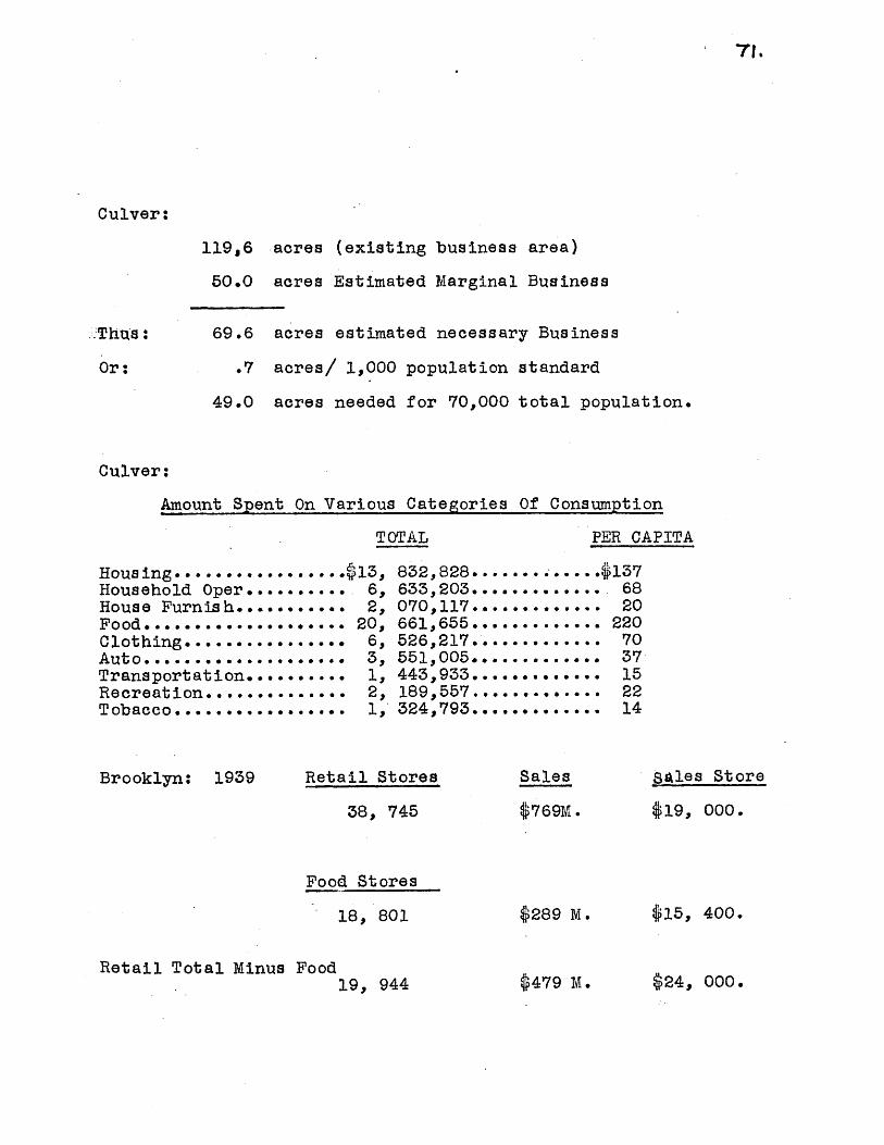
71.
Culver:
119.6 acres (existing business area)
50.0 acres Estimated Marginal Business
Thus: 69.6 acres estimated necessary Business
Or: .7 acres/ 1,000 population standard
49.0 acres needed for 70,000 total population.
Culver:
Amount Spent On Various Categories Of Consumption
TOTAL
Hous ing........Household Oper.House Furnish..Food...*... . .Clothing......Auto..... ....Transportation.Recreation.....Tobacco........
Brooklyn: 1939
... .
. .. .
. . *6
... 0
.613,
. 6,
. 2,
. 20,
. 6,
. 3,
. 1,. 2,. 1,
832,828.633,203.070,117.661,655.526,217.551,005.443,933.189,557.324,793.
Retail Stores
38, 745
PER CAPITA
..1376820
22070
,. 37152214
0~
Sales
$769M .
sales Store
$19, 000.
Food Stores
18, 801
Retail Total Minus Food19, 944
$289 M.
$479 M.
$15, 400.
$24, 000.

72.
CIRCULAT ION
In order to carry out the community principle,
extra-community traffic should be diverted on perimeter
roadways, with the internal circulation system rigidly-
employed for local access.
A new limited-access cross-Brooklyn expressway to
parallel the Long Island Railroad, proposed by the old
Mayor's Committee on City Planning in its 18-year high-
way program (project #32), and indicated by The Master
Plan of 1941 (report # 1,974), would completely surroundCulver with major streets. Access would be allowed at
Ocean Parkway and New Utrecht Avenue; 18th Avenue, link-
ing up with southwestern Brooklyn, and McDonald Avenue
reaching the southern part, would cross but with the 200'
expressway. Since the 9-mile long highway would connect
the borough belt system, Brooklyn-Battery Tunnel, a pro-
posed Narrows crossing to Richmond, and eventually Man-
hattan's arterial system with the parkways of Queens
and Long Island, it will not be considered a community
improvement. It was estimated in 1940 that such a road
would cost §7,000,000 for land acquisition, and $9,00,
000 for construction. The total of $16,000,000 would be
spait, the municipality sustaining land costs and appro-
ximately one-third of the development price, with the
Federal and State governments providing $6,000,000 for
construction purposes . It would probablybe of mrodem dedgi, six

73.
lanes of 72', 20t median strip, and 100 or more feet of
landscaped buffer.
Church Avenue and 13th Avenue are principal roads
which have been, logically linked in the proposed street
system. At present, Church Avenue is checked at 36th
Street, with a branch meeting 14th Avenue. Seven hund-
red feet from Church ^Ivenue's terminus, 13th. Avenue
ends at 36th Street. Since the two Avenues are vital
East-West links, they should be connected t o avoid the
existing confusion and to provide direct, efficient ac-
cess from other communities into the main shopping cen-
ter.
Trucks servicing 13th Avenue shops or industry
would use 36th Steet exclus.ively, thus eacaping conflict
with passenger cars. A buffer between industry and resi-
dence would act as a shock-absorber against inharmonious
land uses.
Access to the community would flow along a few stra-
tegic arteries, leading from the four belt roads. Al-
though McDonald and 18th "venue provide ingress from the
southern side, it is hoped that in the long-range scheme,
both might be transformed intolbcal streets. Bus routes
would run along the new expressway, thereby destroying
the need for 18th Avenue as a mass carrier. A bus route
along Ocean Parkway would convert McDonald Avenue into a
74.
minor street and its tratVway trackage could be removed.
Church Avenue's tracks would also be useless if Ocean
Parkway's bus were to connect with bus lines running east-
ward and westward, possibly at Church Avenue and Caton
Avenue.
The use of a through or by-pass street system is a
technique for efficient traffic - handling; simultaneously,
neighborhood boundaries can be maintained, wherein local
activities can be conducted safely. Occasional loop streets
and cul-de-sacs aid in retaining purely-residential traffic.
PUBLIC BUIIDINGS.
A library and police station have been provided in
this year's Capital Budget. However, no locations have
been aelected. It is proposed that the library serve
the entire community from an advantageous centgral site
near the main shopping center. A police station could
be placed in the twenty-acre sitte grouped with other
public buildings in a modest civic center.
A health center has been designated by the Master
Plan of Health Districts to be situated generally in
the Culver vicinity. It is proposed that it be located
in the civic grouping, centrally-located, and close to
the High School. The duties of the health unit would
be prevention of ills and conservation of health, in
addition to health education programs.

746.
PUBLIC HOUSING.
The land north of 13th. Avenue had been chosen as
the primary rehabilitation area, suitable for public
housing, in addition to a new elementary school and 13th
Avenue shopping center. P.S. 103 would serve as a neigh-
borhood center, and the existing New Utrecht Avenue stores
as local commercial use. A new grammar school, slightly
larger than the other community schools, would serve about
10,000 people.
Since this section has shown evidences of evolving
into future slum, it might be important f-or the city to
attack the roots. Population in census tracts 220 and 222
have increased only 1-5% between 1930 and 1940; tracts
224 and 226, also in the redevelopment area, decreased
1-10% in the ten-year period. These figures are more graphi-
cally-portrayed in accompanying thesis maps showing over-
lays of "Net Densities", "Population Change, 1930-1940,"
and Dwellings Without Mechanical Refrigeration." In all
three cases, the darkest colors indicating worst conditions
fall generally in these tracts. Thus, the falling-off of
population coincides with high. net densities of almost 200
people/acre,- high percentages, 40-60%, of dwellings with-
out mechanical refrigerators. On three of the blocks dwel-
ling units were constructed before 1899; the great percen-
tage of blocks has houses dating from the years 1900-1919.

On five of the blocks over 60% of the apartments is in
need of major repairs. And on six blocks, over 19% of
the units have 1.5 or more persons per room.
Furthermore, it is just this area which lies direutly
in the borough-wide path of blight. The fire can spread
to satisfactory parts of Culver, if it isn't blocked.
In Culver, there are 2,961 families paying rentals
of less .than $30 per month. Since these families come
within the income limits set by the New York Public
Housing Authority in its projects, they are to be re-
housed on 75 acres of land north of 13th Avenue. he area
today is deteriorating, losing population, and in need
of aid. The 3,000 low-rent families are in need of de-
cent housing with adequate surrounding open space. It
is intended that the local Housing Authority assume the
responsibility for clearing the land, and disposing the
new apartment units in such a way as to take full ad-
vantage of the utilities which are beneath the present
streets. In this way, the subserranean facilities are
not wasted, and the surfaces representing 32% of the to-
tal land area, are transformed into informal green space-
The project would have another beneficial effect in that
the community, being invaded by the spread of blight from
the northwest, would possess a buffer of open-plan hous-
ing and recreation and park area.

The Annual Reports of the New York City Housing
Authority were used to assemble post-war data on all
phases of project construction and financing.5).
Wherever possible, Brooklyn projects were employed as
guides in ascertaining density standards, construction
and 'development costs, etc. in current practice.
Standards and averages used were:
Average Monthly Rent: $26/dwelling unit(includingutilities).
Coverage: 20%Construction Cost: $4,000/dwelling unit.Development of Park, Landscaping, and Recreation:
$125,000/acre.60 families/6-story apartment.5 6-story buildings/acre.
Thus, there would be 1500 families housed in 25 6-
story elevated apartments, and 1461 families in 48 3-story
walk-ups. Seventy-three buildings would cover about 15
acres, and the remainder would be open space. Piece-
meal demolition with concurrent family displacement is
recommended. Thus the displaced persons would be re-
housed in some city-wide plan, while gradual public
housing construction was effected.
(45) N.Y.C. Housing Authority, Annual Report,(1944 to 1947)

7S5.
A . DEVELOPMENT COST:
Construction........... ..... $11,844,000Site Acquisition
(assessed value plus 15%).........5,278,500Park, playground, landscape Devel.. 6,250,000
Tote Development Cost......... 23, 372,500
B. FINANCING:
23,372 Bank loan.2tfo interest rate; 45-year amortization;- 3.40%level payments.
Annual Debt Service Required............$794,665Available annually for bond redemptionfrom rentals........... ............. .177,660
$617,005
Required annual subsidy from Federal, State,and City. ($208/family/annum).
C. PROJECT BALANCE SHEET:
INCOMEItem Per Apartment/onth Per Project/year
Dwelling Unit Rentals $26.00 $Other Income 3.20Less Vacancies .20
Total Income 29.00 1,030,428.00
EXPENSESOperating ServicesManagement 3.00Operating Services 2.00Dwelling Utilities 6.00Maintenance and Repairs 5.00Insurance .. 70
Other Expenses:Reserves for Repairs, Replacements,
vacancy and collection losses 2.80Bond Service chargeable to operations.1.00Other reserves and expenses .20
Total Expenses 20.00 710,640.00319,788.00NET EXCESS OF INCOME OVER EXPENSES 9.00
DISPOSITION OF NET INCOMEDebt Service 5.00Payments In Lieu of Taxes 1.50Voluntary Additional Tax Payments 1.00Operating Improvements 1.40Project Working Capital .10

so
TIMING OF IMPROVEMENTS
ACQUISIT ION PLANS C ONSTRUCT ION
100' strips alongMcDonald & N.U.Avenues. Sitesfor Schools, re-creation, pub .blds.
Land for 13thChurch connection.
Zoning inconformancewith Plan.P.S. 103.P.S. 104.
P.S. 131L i sR4*tRy
Public Housing P.S. 134Site,13 Ave. Shopping Public Hous-Center ing,13th. Av.
Shopping.
P.S. 180Health Build-ing
P.S. 179High School
Park Site
Demolish P.S. 103,Playground forP.S. 164 & J.H.S.
P.S. 103 & Play gr.P.S. 164Buf fters/alongMcDon.& N.U. AvenuesPedest. Overpass-18 Ave.
LibraryP.S. 131 & PlaygroundDemolish P.S. 1343iChurch-13th AvenueConnection.
P.S. 139 & PlayroundPublic Housing13th Shopping.
P.S. 180 & PlaygroundHealth BuildingDemolish P.S. 179.
Police Station P.S. 179High School
Rights of Wayfor Loops &Cul-de-sacs in1 neighborhood.
I
Police StationPark.
Close Streets.Loops and Cul-de-sacs in Neighborhood
195619571958
it"I
New Highway. New Highway1959 Neighborhood streets. Shopping Church
Church Ave. Shopping Avenue NBuffer along Industry
1960 NBC
it
ew Highway.
aighborhood Streets.uffer strip.hurch Ave. Shopping.
1949
1952
1953
1954
1955

'I-
ESTIMATE OF PUBLIC COSTS (*).
A. LAND ACQUISITION
Description
Buffers1001 strip along N.U.
Ave.100 strip along McDon.
Ave.strip along 36-37 St.
Acres CostAnnual
Debt Service
5.5 %552,0oo
16.0
9.0
704,375
795.800
Total
Park
Public Sites
30.5
5.2
35.7
2,103,925
524,400
5,207,200
189,070
47,196
26,250 (a)451,148 (b)
Local Loop Streets
13th.--Church Connection
Church Ave. Shopping
13th. Ave. Shopping 13.0 1,584,000 18,550(c)77,760(d)
TOTAL LAND ACQUISITION ----- 10,187,525 879,094
Compilation of all costsPublic Works Department;Prof. A. J. Bone
Assessed Valuation plus$750,000 for 30 years @44,45,4230 for 10 years @530,U00 for 30 years @854,000 for 10 years @
based on Departmental data;Capital Budget; Dodd McHugh;
15%..035 level payments..090 level payments..035 level payments..090 level payments.
3.0
3.5
2.9
200,000
145,000
423,000
18,000
13,050
38,070
(1)-(a)(b)(c)(d)

S2.
ESTIMATE OF PUBLIC COSTS
B. CONSTRUCTION
Description Period Of Development Cost D'ebt .MaintenanceAmortization Service Operation
Library 30 @ 957,000 35,400 26,400Health Center 30 873,000 31,700 49,000Police Station 30 260,250 9,200 4,500High School 30 3,000,000 105,000 27,0006 Elementary Schools 30 4,200,000 147,000 72,000
Sub-total 30 $9,290,250 $328,300 $178,900
41.1 acres Play 10 4,110,000 369,900 36,9006.5 acres 10 65,000 5,850 1,300Park 10Buffers 10 305,000 27,450 6,100
Local Straeets 10 126,000 11,340
13th-Church Connection 10 52,500 4,625Pedestrian Overpass 10 15,00 1,350
Parking & Landscaping 10 65,000 5,850 25,000
Sub-total 10 $4,738,500 $426,365 $69,300
$754, 665 $248,200$14,028,750T otal Development
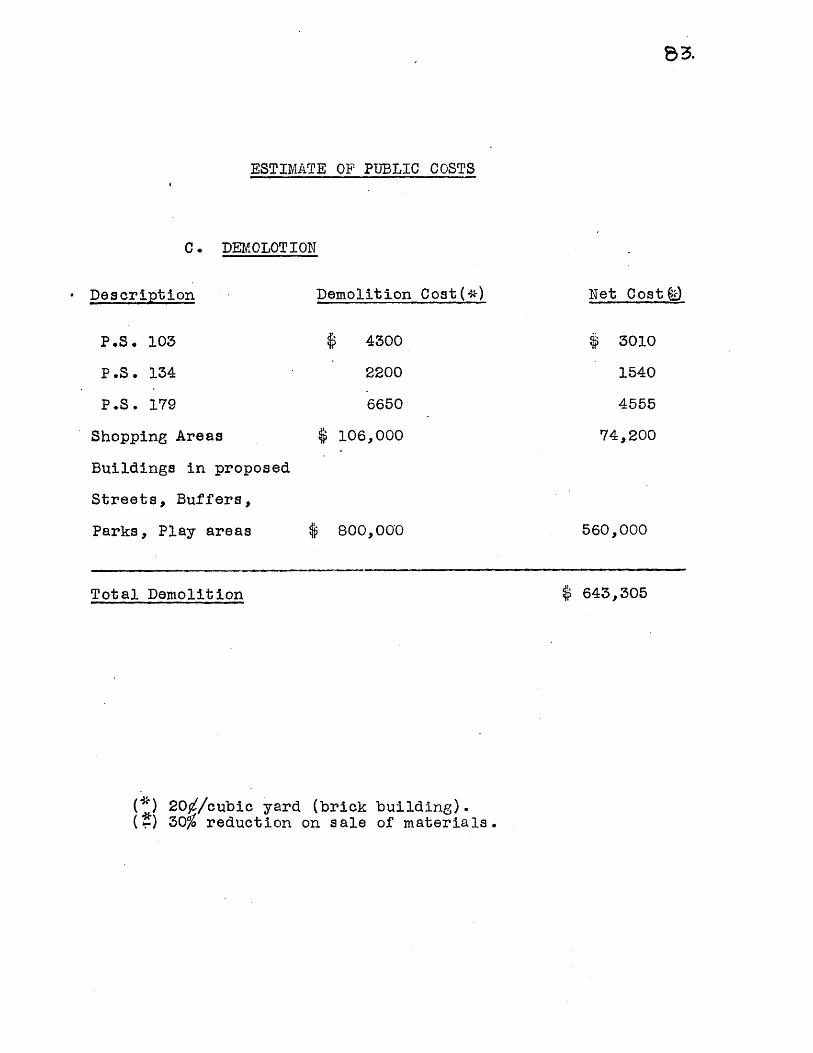
e~3.
ESTIMATE OF PUBLIC COSTS
C. DEMOLOTION
- Description Demolition Cost(*) Net Cost f±)
P.S. 103
P.S. 134
P.S. 179
Shopping Areas
Buildings in proposed
Streets, Buffers,
Parks, Play areas
Total Demolition $ 643,305
(*) 20$/cubic yard (brick building).(?) 30o reduction on sale of materials.
4300
2200
6650
3010
1540
4555
106,000 74,200
6 800,O0O0 560,000

T4.
D. SUMMARY: ESTIMATE OF PUBLIC COST.
Description
Land Acquisition
Construction
Demolition
Cost
010,187,525
14,028,750
643,305
AnnualDebt Service
879,094
754,665
MaintenanceOper ion
248,200
6 24,859,580 $1,633,759 $248,200
E. ANNUAL CHARGES
Debt Service
Maintenance & Operation
$41,633,759
248,200
1,881,959
Annual Savings on
Street Maintenance (*) 440,000
MUNICIPAL TOTALANTUAL COST $1,441,959
* $1/cubic yard for surface maintenance, s removal,sanding, street cleaning on difference between exist-ing and proposed street area.
Total

POPUIATION AFTER 12-YEAR COTMhJNITY PIAN
Population Famili es
DISPIACED BY:
Recreation and Public Buildings 5 250
Park and Buffers 2 800
Highway & Connecting Road 1 700
Neighborhood Loop Streets 2 900
Shopping 3 550
Public Housing 9 000
TOTAL DISPIACED 25 200 7 200
Rehoused in Public Housing 2 961
Net Displaced 4 239
1960 Population Before Plan 26,000
1960 Population After Plan 73 980 21,761

86.
PROPOSED LAND USE
Residence
Commerce
Industry
PlaygroundsParkBufferOther
Public Land
Semi-Public Land
NCRES618,3
56.3
% of TOTAL57.0 %
5.0
17.0
44.66.5
30.511.1
Streets
92.7
47.3
260.0
9.0
4.0
24,0
TOTAL IAND AREA 100,01091,6

r.
STANDARDS OF COST
Debt. Service
MaintenanceOperation
Streets & Parking
Parks
10 years: 90% of Development30 years: 3-1o of Development
usually 2% of Development.(Playgrounds: $900/acre;Parking: 30/s .y.)
Construction: $3/square yard forbituminous concrete.
$1.50/s.y. forbituminous surflacingMaintenance: 307s.y. surface
40 /s.y. snow removal30Vs.y. street cleaning
Landscaping: 10 /s.y.
Development: 010,000/acre
Playground Development: GlOO,000/acre
Elementary School
High School
Development:
Development:
$20,000/room
p 1,200/seat.
New York City Capital Budgets.Public Buildings

W8
CULVER: FAMILY EXPENDITURES OF INCOME (*)
Percentage Spent For:Monthly Rental Percentage of Total All Items Food Housing
Under 12 % 102% 40% 25%
39- 39 31 98 35 23
$40 - $49 26 93 31 20
g50 - $74 24 89 28 18
$75 - 699 :4.6 82 20 17
100 - $149 2. 82 20 17
$159 - Up 0.4 82 20 17
Household Furnishings Clothing Auto Transportation MedicalCare
10 2 8 2 3 4
9 3 9 4 2 4
9 3 10 6 2 4
9 3 10 5 2 4
11 3 9 6 2 5
11 3 9 6 2 5
11 3 9 6 2 5
Recreation Education Tobacco Other Items
2 -- 3 33 2 23 2 23 2 34 2 24 2 24 2 2

Amount Spent For:Average Annual Number of Tbtal Food Housing Household
Income Group Families
2 961 $
7 649
6 415"
5 922
1 135
493
99
t,849;3900 1 539
13,768,200 4 818
17,037,500 5 281
23,688,000 6 632
6,810,000 1 362
4,14.4,000 828
990,000 198
720
870 3
625 3
640 4
000 1
800
000
962
166
409
263
157
704
168
322
686
500
840
700
480
300
384
1-239
11563
2 131
749
455
108
930
138
375
920
100
840
900
TOTAIS 24, 674 $ 70,287,000$20 661 655 13832 828 6 633 203
----------------------------- ------ ------------- -----------
Furnishings Clothing Auto Transportation Recreation Tobacco
76 986 307 944 76 986 115 479 76 986 115 479
413 046 1 239 138 550 728 275 364 413 046 275 364
511 125 1 533 375 1 022 250 340 750 511 125 340 750
710 640 2 13119200l 184 400 473 760 710 640 473 760
204 300 749 100 480 600 136 200 272 400 68 100
124 320 455 840 -248 640 82 880 165 760 41 440
29 700 108 900 59 400 19 800 39600 9 900
2 070 117 6 526 217 3 551 004 1 *3 933 2 189 557 1 324 793
Adapted from: National Resources Planning Board, FamilyExpenditures In The United States, (Washington, 1941), p. 68,Table 202 on Metropolises.
1300
1800
2500
4000
6000
8000
10000

AVERAGE ATTENDANCE
Elementary 1917-P.S. 103 1441
P.S. 131 1288
P.S. 134 942
P.S. 164 2325
P.S. 179 1799
P.S. 180 372
P.S. 192 -
Total 8,167 7,971 8,745 9,075 10,041 11,997 11,030 10,777 9,739 8,764 7,464
J.H.S.
P.S. 192 -- - --- 1476 2709 --- --
P.S. 223 -- 2895 2760 2503 2210 2038
Total --- 1476 5604 2760 2503 2210 2038
1918
1502
1258.
828
2208
1814
361
1919
1665
1310
1007
2408
1971
384,
1920
1774
1282
1208
2416
2006
389
1921
2011
1364
1439
2606
2203
418
ULVER SCHOOLS
1925 .9193 935 1938 1941 l14
1771 1156 1303 124 1159 796
1813 1937 1673 1508 1426 1160
1241 1029 923 815 670 610
2688 2044 1820 1502 1334 1104
2489 2088 1834 1732 1635 1519
1363 1541 1345 1199 1075 1012
632 584 846 772 682 635
65i1 1033 967 783 628
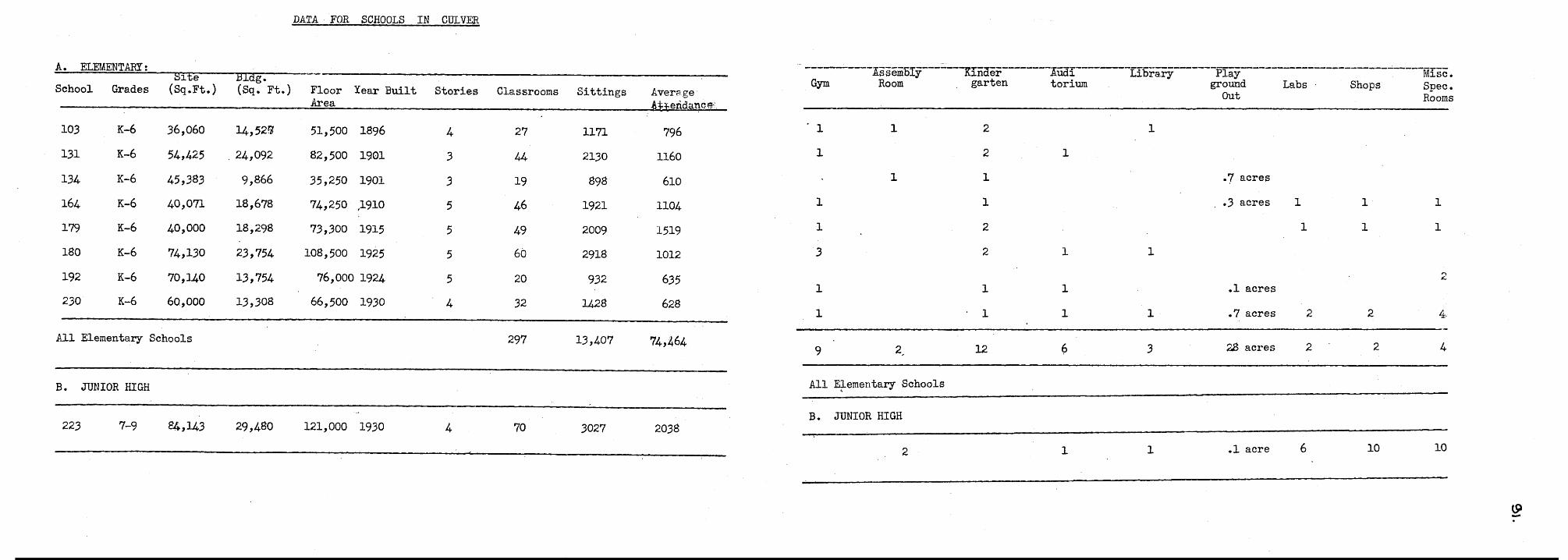
DATA- FOR SCHOOLS IN CULVER
A. ELEMENTARY:School Grades
103
131
134
164
179
180
192
230
K-6
K-6
K-6
K-6
K-6
K-6
K-6
K-6
(Sq.Ft.)
36,060
54,425
45,383
40,071
40,000
74,130
70,140
60,000
(Sq. Ft.)
14 , 52 '
24,092
9,866
18,678
18,298
23,754
13,754
13,308
FloorArea
Year Built Stories Classrooms
51,500 1896
82,500 1901
35,250 1901
74,250 1910
73,300 1915
108,500 1925
76,000 1924
66,500 1930
4
3
3
5
5
5
5
4
27
44
19
46
49
60
20
32
Sittings
1171
2130
898
1921
2009
2918
932
1428
Average,A id
796
1160
610
1104
1519
1012
635
628
All Elementary Schools 297 13,407 74,464
B. JUNIOR HIGH
223 7-9 84,143 29,480 121,000 1930 4 70 3027 2038
$$er an
Library Play Misc.Gym Room garten torium ground Labs Shops Spec.
out Rooms
1 1 21
2
.7 acres
..3 acres 1 1 1
1 2 1 1 1
3 222
11 1 .1 acres
.7 acres 2 2 4
9 2. 12 6 3 28acres 2 2 4
All Elementary Schools
B. JUNIOR HIGH
2 -.lacre 6 10 10

SquareFeet
Lib. Area Popul. Popul.(Populat . 15
Popul.5
Square Reacers'SeatsFeet Seats, 1,000
Name Location Plant Area Served) 5 - 14 Over Over Per .Cap Ove
Kensington McDonald Rented 3,068 56,614 7,496 43,730 51,226 .06 .46 .90
Ditmas Stores
Boro Park 13th.Ave. Rented 3,389 86,713 13,274 68,262 81,536 .04 45 .55&
52 Street Stores
Totals 6,457 143,327 20, 7O 111,992 132,762 .05 91 .68
Registration of Population Reg. Circulation (Vol.)
ota Adult Juv. Total Adult Juv. Total Adult
Kensington 15,098 9,112 5,986 27.6 20.8 79.9 177,803 132,203
Boro Park 19,287 11,730 7,557 12.2 17.2 56a9 238,714 142,054
Totals 34,385 20,842 15,543 15.0 19.9 68.0 416,517 274,257
r 5

B 0 0 K S T 0 C K VO L.U M ES /C A P I T AName Total Adult Juv. Total Adult Juv.
Kensington 17,996 13,958 4,038 .35 .32 54,
Boro Park 16,690 12,880 3,810 .21 .19 .29
Totals 34,686 26,838 7,848 .26 .24 .38
Circ./Capita StaffJuv. Total Adult Juv. (Prof)
Kensington 45,600 3.26 3.02 6.08 6
Boro Park 96,660 2.75 2.08 7.28 7
Totals 142,260 3.1 2.4 6.8 13

LIBRARY STUDY II.
DEGREE TO WHICH PRESENT FACILITIES MEET MINIMUM STANDARDS
BOOK STOCK BUILDING FACILITIES.
Adult
Min. Standard
Kensington
Boro Park
TOTAL
.6Vol./cap.
53%
32%
40%
Juvenile
1.5vol./cap.
36%
19%
25%
Floor Space
233Q.Ft./Pers.Served24%
16%
20%
Seats
1.5/1,000pers.5 yrs. & Over60%
37%
48%
1/4560 pop.5 yrs & Over54%
39%
45%
REGISTRATION CIRCULATION
Adult Juven.
Min. Standard 30% of 55% ofAdult
Pop.Juv.Pop.
6.5 vol./cap. 20 vol/cap.
Kensington 69% 145% 47% 30%
Boro Park 57% 104% 32% 36%
TOTA 60% 117%37%34%
STAFF
Adult Juven.
37% 34%TOTAL 60% 117%

-NET DENSITIES IN CULVER BY CENSUS TRACT
Net Resid. Acres
218220222224226228230
232234236238240242
462470472474476478480
484486488490494496
498500
Porulation/net acre
268238130170155224215
1.6100125.032.016.318.526.1
41.329.029.029.025.717.0
12. 213.420.228.0340538.327.5
23.427.824.311.511,032.6
34,811.0
Tract
198145180142160127
89100110111106124120
178248140123234135
9192

19 4 0 U S IN G
Census TotalCensusTract
218
220
222
224
226
228
230
232
234
236
238
240
242
462
25715 4502
U UU U P A IIU
Total OwnerDwellings Occupied
T otalStructures
29
124
266
442
235
311
388
602
260
254
308
281
210
108
Totals 7887
99
515
814
1346
655
1045
1390
2063
1138
1458
1132
1187
545
307
24
VacantOther
201735
TenantOccupied
88
460
651
1012
496
824
1134
1652
964
1279
911
944
400
234
1
37
134
280
145
181
229
354
135
142
178
144
112
3265
C E N 8 U S*
1017
T B V U h B
Vacant,for Sale
10
17
29
54
14
40
27
57
39
63
43
----- ft
48
25
7
m -- -
=---
470 227 420 110 295 14 1
472 202 631 130 448 48 5
474 361 745 211 489 45 ---
476 477 1217 253 884 80 ---
478 468 1338 272 982 84
480 302 917 170 711 34 -2-
484 266 1106 153 928 25 --
486 324 1020 181 803 33 -3-
488 321 911 222 673 15 -1-
490 135 457 72 362 23
494 104 740 59 660 21
496 477 1217 253 884 80
498 276 881 176 678 27Totals-------------------------------------
500 129 394 102 277 15 ---
* Source: U.S. Bureau of the Census, 1946 Census.
** Does not include entire tract where blocks fall outside community boundaries

1940 HOUSING CENSUS *
20639 .3450 7375 9458 355 45. 33
D-WE'LLING UNITS BY YEAR B U I L T
Number 1930 1920 1900 1899 Average Mont hlyReporting 1940 1929 1919 Earlier Rent
99
80
203
802
653
863
759
1556
954
1362
674
1040
538
8
-65
6
1 .
1
54
206
638
250
422
22
28
36
K 43
88
8
480
150
176
326
468
168
316
221
71
34
82
619
636
380
603
1326
403
247
249
275
280
13
89
9
2
5
31. 67
44.00
45.00
35..95
29.08
36.62
36.02
35.66
57.21
56.39
51.49
46.00
49.72
7
9
7
27
15
l 9 4 0 H 0 U S I N G C E N 8 U S *
g2gg 991 :9T 6-------------------------------------------------------------
LT*p91 OLAT 089 8/ASLe* 9:p T 69T, 169 92T 9611E
09*99 1 91 229 L92: 9
06 fP: 99 /L61 9
08 0L~p 1 /LT2 01£ OV9
V0929 :VL:61 -196
0Q9* 1£ 2 909 Tag2V 9fr06
981V99 O19 /A6C 99 3£/A
16QOO 9 Leg 29V? /6 69TT
480 2 69V 169 921 9611
00099 011 91fr 89 969
99 £ 9 ;11 0
iW9TV 69 9 6V 69£

1940 POPUL ATION CENSUS *
Census * *
Tract Total Male Female Native
218
220
222
224
226
228
230
232
234
236
238
240
242
462
470
472
430 214 216
2405 1170 1235
3265 1580 1685
5422 2776 2646
2523 1290 1233
4184 2116 2068
5609 2790 2819
8166 4120 4046
4193 1984 2209
5218 2554 2664
4139 2025 2114
4122 2005 2117
2170 1030 1140
1086 531 555
1338 660 678
2214 1106 1108
Foreign Other Under 5 714 15-24 25-34 35-44 45-54 55-64 65 andWhite Born Races 5
270
1485
2012
3356
1752
2636
3247
4749
2589
3384
2546
2674
1402
779
870
1475
160
915
1240
2060
771
1545
2361
3394
1572
1790
1578
1434
767
298
468
722
Over Over
--- 20
5 120
13 158
6 323'
--- 196
3 195
1 324
23 387
32 296
44 363
15 262
14 271
1 135
9 81'
80
17 129
1988 1106 21 '163 450 569 604
21 and
70 89 80
310 475 500
406 626 679
865 3117 964
442 537 470
714 889 731
981 1118 973
1425 1425 1250
528 705 978
730 831 1319
557 699 937
613 703 901
330 405 441
138 171 255
202 242 269
336 414 465
60
360
496
774
324
635
889
1265
689
905
673
685
326
171
205
357
56
310
392
654
270
511
664
1063
472
522
499
459
261
120
162
255
35
205
328
452
195
327
409
662
356
360
329
298
156
78
109
165
20
125
180
273
89
182
251
406
169
188
183
192
146
7r4
69
.93
285
1720
2344
3569
1561
2728
3598
5248
2997
3688
2938
2830
2045
1289
937
1524
474 3115 1554 1561 506 402 277 144 2115

476 3650 1824 1826 2362 1271 17 172 520 681
478 4739 2320 2419 3336 1389 14 318 687 839 1012 737 553 376
480 3260
484 4166
486 3779
488 3418
490 1411
494 2575
496~ 4395
498 3175
500 1000
1630
2015
1881
1674
667
1213
2179
1575
460
1630
2151
1898
1744
744
1362
2216
1600
540
2294
2905
2510
2430
1049
1916
2881
2190
800
963
1229
1263
968
357
643
1505
975
200
3 194
32 262
6 203
20 183
5 94
16 162
9 232
10 205
-- 70
496
596
611
477
150
274
631
438
130
541
690
752
598
224
390
781
519
160
617
877
606
658
324
650
826
69
220
581
741
615
635
258
450
716
536
160
415
480
534
414
159
293
565
342
130
227
322
277
287
117
224
403
228
80
217 3245
189
198
181
166
85
132
241
138
50
2251
2902
2451
2424
1051
1940
3080
2259
550
OTALS,46,945 61,887 32,944 5,598 17,473 15,342 7,611 66,119
95,167 46,943 61,887 336 14,107 19,071 11,386 4,579
* Source: U. S. Bureau Of The Census, Census Of Population, (1940).
** Does Not Include Entire Tract Where Blocks Fall Outside Community Boundaries.
726 59.3 429 329 200 2550
T
99.
BIBLIOGRAPHY:
Brooklyn Daily Eagle. Brooklyn City Plan. January 18, 1914.
Brooklyn. New York. 1946.
Flatbush. New York. 1946.
Brooklyn Edison Company. Brooklyn Market Survey. 1936.
Bureau of the Census. W.S. Department of Commerce.16th Census of the United States. 1940. Housing Brooklyn
Borough.
Population New York City.
Retail Trade New York City.
Cohen, Henry.
Consolidated Edison
Cook, Catherine M.
Mayor's Committee on
McHugh, F. Dodd.
A Study of School-Community Relation-ships in Brooklyn, New York. BrooklynCouncil for Social Planning. 1944.
Company of New York. Survey of the NewYork City Market. 1945.
New York's Population 1790-1970. 1946.
Planning Schools for Tomorrow.Washington. 1943.
City Planning. New York. 1940.Basic Factors in the Planning of theCity of New York. (Volume I).
The Planning of Public Services for theCity of New York. (Volume II).
Programming Public Improvements in theCity of New York.
Cost of Public Service In Residen-tial Areas. New York. 1942.

l0o.
Municipal Club of Brooklyn. Brooklyn, The Home Boroughof New York City. 1912.
National Committee on Housing. Planning NeighborhoodShopping Centers. New York. 1945.
National Recreation Association. Standards for NeighborhoodRecreation Areas And Facilities.New York. - 1943.
National Resources Planning Board. Estimates of FuturePopulation of the United States1940-2000. Washington. 1940.
Family Expenditures In The UnitedStates. Washington. 1941.
New York City Departments. Interview information.
New York City Board of Education. Annikal Financial andStatistical Report. 1944-1945.
Annual Financial and StatisticalReport. (Each year from 1917 to 1943).
New York City Charter. Adopted January 1, 1938.
New York City Housing Authority. 13th Annual Report. 1947.
10th Annual Report. 1944.
New York City Planning Commission. Program for the PublicLibraries of New York City. 1945.
Proposed 1948 Capital Budget and1949-1953 capital Program. October,1947.
New York Times. 1945 Census: An Interim Report. 1945.
Regional Plan Association, Inc. The Economic Status of theNew York Metropolitan Region. NewYork. 1944.
Recommended