Embed Size (px)
Citation preview

02 ZONING
rev 11/21/2016
CITY OF AUSTIN

ZONING
Page 2 of 19 rev 11/21/2016

ZONING
Page 3 of 19 rev 11/21/2016
GENERAL OVERVIEW
GENERAL INFORMATION This packet outlines the procedures and submittal requirements necessary to obtain a change of zoning within the City of Austin jurisdiction (full-purpose and limited-purpose City limits). The regulatory requirements and procedures for approval are defined in Chapter 25-2 of the Code of the City of Austin. Chapter 25 was adopted by City Council in order to protect the health, safety and welfare of the Austin community.
Additional information about the zoning process and code requirements can be obt ained prior to submitting a z oning application by contacting the Development Assistance Center (DAC) on the 1st floor of the One Texas Center, 505 Barton Springs Road, phone 974-6370, or by visiting the City of Austin’s Development Process and One-Stop Shop website at http://www.austintexas.gov/department/development-services.
WHAT IS ZONING? Zoning is the division of land within a jurisdiction into separate districts within which uses are permitted, prohibited or permitted with conditions. Zoning establishes site regulations, such as building heights, bulk (density/floor-to- area ratio), setbacks, building coverage, impervious cover, etc. Zoning is a power granted to municipalities by the State in order to promote public health, safety, morals, or general welfare, and to protect and preserve places and areas of historical, cultural, or architectural importance and significance.
ORDER OF PROCESS Zoning is usually the first step in the City of Austin's development process. A Neighborhood Plan Amendment may also be required if the property is located within an adopted Neighborhood Plan area and a change to the adopted plan and/or the property’s future land use map (FLUM) designation is necessary, A Neighborhood Plan Amendment may be processed concurrently with a request for a zoning change. Prior to the construction or occupation of a new or expanded land use/business on a site, other steps including subdivision, site plan, or building permit and i nspection, may be required. Contact the Development Assistance Center for additional information.
Applications may be submitted on any working day at the Intake Center, 4th floor, One Texas Center, 505 Barton Springs Road, and may be found at http://www.austintexas.gov/page/land-use-applications#zoning. Please call 974-7208, 974-2681, or 974-2350 to schedule an appoi ntment. A written report from staff will be av ailable to the applicant andt he public several days before the item is scheduled for review by the Land Use Commission. Zoning requests aretypically heard by the assigned Land Use Commission on the fourth or fifth Tuesday of the month following thedate of submittal (approximately 6 to 7 weeks), and by the City Council on t he fourth Thursday followingthe Commission’s recommendation.
CASE MANAGER Each zoning application is assigned to a review team. The Case Manager will serve as liaison between you and the City of Austin and function as your main point of contact. Once your application has been submitted, any questions, problems, conflicts, etc. should be di rected to the Case Manager. I f you need t o see your Case Manager, it is suggested an appointment be made to ensure the Case Manager is available.
NEIGHBORHOOD, COMMUNITY AND ENVIRONMENTAL ASSOCIATIONS Information concerning neighborhood associations, community groups and env ironmental interest groups in the area of the zoning request is available at the Development Assistance Center.
URBAN RENEWAL ZONE The site may be l ocated within one of five Urban Renewal Plan districts created in the 1960s to allow clearance and redevelopment of certain parts of East and Central Austin. The Urban Renewal Plan areas are subject to specific land use and development standards that are unique to each area and applicable to all public (including the State of Texas and the University of Texas) and private entities. Contact the Development Assistance Center for information regarding the Urban Renewal Plan districts.
HOW TO OBTAIN INFORMATION Clerical staff and planners are available by appointment or on a first-come, first-served basis each weekday between 9 a.m. and 12 p.m. at the Development Assistance Center, 1st floor, One Texas Center, 505 Barton Springs Road (512-974-6370).HICS AND FINANCIAL DISCLOSURE INFORMATIONIf you or your agent/representative were a City employee or City official within the past 24 months, you may be subject tothe City’s Ethics and Financial Disclosure requirements (see City Code Chapter 2-7). Copies of Chapter 2-7 are availablefrom the City Clerk’s Office.
TIMEFRAME FOR PROCESSING A ZONING APPLICATION

ZONING
Page 4 of 19 rev 11/21/2016
SUBMITTAL INFORMATION AND REQUIREMENTS
When filing a zoning change, the applicant or the applicant's agent shall submit the following information in person to the Intake Center of the Planning and Zoning Department, 4th floor, One Texas Center, 505 Barton Springs Road.
A. APPLICATION FORM - Type or print all information. One copy of the completed application form shall be submittedin which the following items shall be addressed:
1. Owner - Please indicate name of current owner. The current owner or authorized agent must apply for the zoningchange.
2. Project Name - Fill in, if applicable.
3. Street Address(es) - Indicate the address or range of addresses for all streets abutting the property. Forassistance, contact Addressing Services of the Communications and Technology Management Department, 10th
floor, One Texas Center, 505 Barton Springs Road.
4. Land Area to be Rezoned - The area of the tract(s) for which a zoning change is being requested shall be shownin square feet or acres. If more than one type of zoning is being requested, identify each tract and indicate sizeand type of zoning being requested.
5. Existing Zoning - Indicate existing zoning and use. If more than one tract is involved, identify tract by numberand corresponding acreage or square footage. Zoning map books are available in the Development AssistanceCenter and at Document and Map S ales in order to verify zoning. If the maps do not reflect what you think is thecorrect zoning, a zoning verification request may be made to Document and Map Sales, located on the 1st floor ofOne Texas Center, 505 Barton Springs Road.
6. Proposed Zoning - Indicate the proposed zoning. If there are questions as to what zoning is needed, contact theDevelopment Assistance Center.
7. Development Assessment - If you have completed a D evelopment Assessment, indicate file number and theIntake Center will verify and apply the refund to your zoning application.
8. Active Neighborhood Plan Amendment, Zoning, Restrictive Covenant, Subdivision and Site PlanRequests - If there are any pending requests on the property covered by this application, please indicate the casenumber(s).
9. Property Description - The property description shall accurately describe only that area for which a z oningchange is being requested. This description shall be by either lot and block of a recorded subdivision, includingplat book and page or document number, or by certified field notes describing only the land area needed for theproposed use(s). If field notes are supplied, two copies are needed using the following format:
a) Prepared on 8½ x 11 paperb) Typed in a standard business typeface (legible)c) Begin with a caption that describes the total tractd) Surveyor's calls includede) End with the words "to the point of beginning"f) Sealed by a registered public surveyor
10. Deed Reference - The volume and page numbers or document number of the deed conveying the property to thepresent owner and the total size of the property conveyed shall be shown. This information is on your deed or isavailable from the Travis County Clerk's Office at 5501 Airport Boulevard.
11. Combining/Overlay Districts - Indicate if your zoning request falls within a Combining/Overlay District. If you areunsure of this information, please check with the Development Assistance Center prior to filing your application..
12. Traffic Impact Analysis (TIA) - This information can be obt ained from your TIA determination (see Item Dbelow).

ZONING
Page 5 of 19 rev 11/21/2016
13. Watershed - A map is available in the Intake Center area. An Intake Clerk will assist you in obtaining thisinformation if necessary.
14. Water, Wastewater & Electric Providers - In most cases, these utilities are provided by the City of Austin.
15. Type of Ownership - If the ownership is other than sole or community property, attach a list of thepartners/beneficiaries/principals and their positions.
16. Owner's Signature - The owner must sign the application or attach a written authorization for the agent. If thereis more than one owner, attach additional owner information to application. Be sure that all signatures are legibleand address information is correct.
17. Agent Information - If designated, this will be t he primary contact. If the agent changes, the Case Managershould be notified.
B. TAX PLATS - Tax plats are used to obtain property owner names and addresses for notification. Tax plats must besubmitted with all zoning applications and shall meet the following requirements
One blueline copy of each of the current tax plats, showing all properties within 500 f eet of the tract for which zoning approval is being requested. Include all plats referred to in the 500 feet surrounding the tract. Outline the subject tract in red. (DO NOT SPLICE THE MAPS TOGETHER).
Tax plats can be obtained from:
. Hays County: Hays County Clerk’s Office; 137 N. Guadalupe Street; San Marcos, phone: (512) 393-7330 � Travis County: Travis Central Appraisal District at Walnut Creek Business Park, 8314 Cross Park Drive,
Austin (U.S. 290 & Cross Park Drive), phone (512) 834-9138. Tax plats for Travis County may be printed from TCAD online, www.traviscad.org.
� Williamson County: W illiamson County Clerk, Justice Center Building, 405 Martin Luther King Street, Georgetown, phone: (512) 943-1515.
For projects located outside of Travis County, applicants must submit a l ist of names and addr esses of all property owners located within a 500-foot radius of the subject tract
C. TAX CERTIFICATE - A Tax Certificate must be submitted with all zoning applications. P lease note that taxcertificates must be or dered in advance of the request and w ill require a nom inal charge by the County. The taxcertificate should indicate that no taxes are owed on the property. Tax certificates may be obtained from:
� Hays County: Hays County Tax Assessor Office; 102 N. LBJ Drive, San Marcos. � Travis County: Courthouse Annex, 5501 Airport Boulevard. � Williamson County: Williamson County Tax Assessor / Collector Office, 904 South Main Street, Georgetown
D TRAFFIC IMPACT ANALYSIS - A determination as to whether a TIA is required must be made prior to submittal of the zoning application. This determination is made by the Planning and Zoning Department. Fill in the indicated portions of the attached TIA determination form and v isit with a P lanner in the Development Assistance Center or with a Transportation Planner in the Land Use Review Division to have the determination completed. If a TIA is required, the Planner will indicate the number of copies to be submitted with the application.
E. APPLICATION FEE - In addition to the base zoning fee, please note that a s ign fee is charged. This fee is figured onthe basis of one sign for each 200 feet of street frontage. No more than three signs shall be required for any case.
F. SUBMITTAL CHECKLIST - A Submittal Checklist for the information which the applicant is required to provide isincluded on page 4 of this packet.
G. ACKNOWLEDGMENT FORM CONCERNING SUBDIVISION PLAT NOTES / DEED RESTRICTIONS - Theapplicant should carefully check these records before signing the enclosed Acknowledgment Form. Plat notes areshown on the face of the subdivision plat. Plats are available at the Map and D ocument Sales or the County Clerk’sOffice, Courthouse Annex, located at 5501 A irport Boulevard. D eed restrictions are recorded at the County Clerk’sOffice, Courthouse Annex.
ZONING
Page 6 of 19 rev 11/21/2016
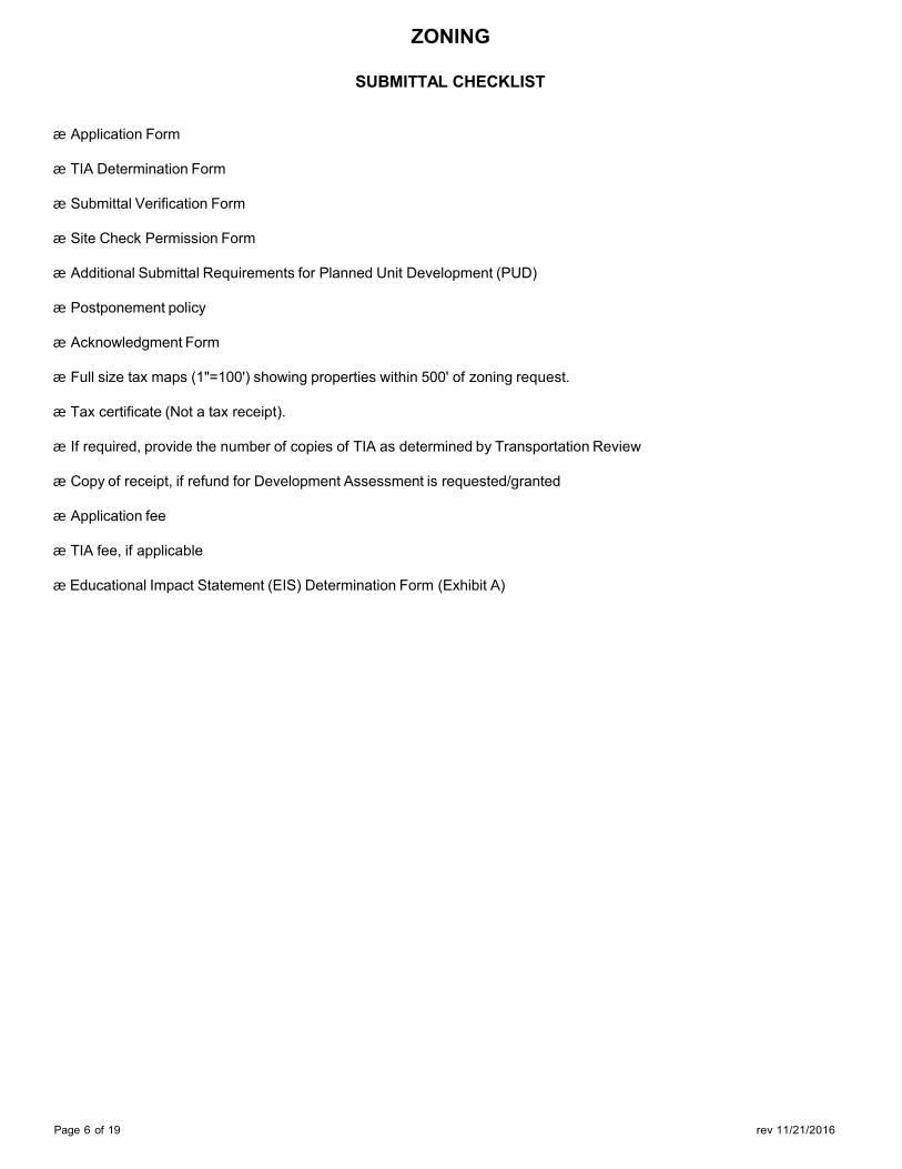
SUBMITTAL CHECKLIST
æ Application Form
æ TIA Determination Form
æ Submittal Verification Form
æ Site Check Permission Form
æ Additional Submittal Requirements for Planned Unit Development (PUD)
æ Postponement policy
æ Acknowledgment Form
æ Full size tax maps (1"=100') showing properties within 500' of zoning request.
æ Tax certificate (Not a tax receipt).
æ If required, provide the number of copies of TIA as determined by Transportation Review
æ Copy of receipt, if refund for Development Assessment is requested/granted
æ Application fee
æ TIA fee, if applicable
æ Educational Impact Statement (EIS) Determination Form (Exhibit A)

ZONING APPLICATION FOR ZONING
DEPARTMENT USE ONLY
APPLICATION DATE FILE NUMBER(S) TENTATIVE ZAP/PC DATE TENTATIVE CC DATE CASE MANAGER CITY INITIATED YES NO APPLICATION ACCEPTED BY ROLLBACK YES NO
PROJECT DATA
OWNER’S NAME:
PROJECT NAME:
PROJECT STREET ADDRESS (or Range):
ZIP COUNTY:
If project address cannot be defined, provide the following information:
ALONG THE SIDE OF APPROXIMATELY Frontage ft. (N,S,E,W) Frontage road
FROM ITS INTERSECTION WITH Distance Direction Cross street
TAX PARCEL NUMBER(S):
Is Demolition proposed?
If Yes, how many residential units will be demolished? Unknown
Number of these residential units currently occupied**:
Is this zoning request to rezone a parcel that contains an existing mobile home park with five or more occupied
units?** If Yes, how many?
Type of Residential Unit: SF, duplex, triplex, townhouse/condo, multi-family, manufactured home:
Number of Proposed Residential units (if applicable): If Yes, how many of the following:
1 Bedroom Affordable 2 Bedroom Affordable
3 Bedroom Affordable 4 or more Bedroom Affordable Unknown ** If 5 or more, tenant notification may be required and a certified form may be required with your application (LDC 25-1-712). Tenants must receive notification at least 270 days before the application is eligible for final ordinance readings by City Council.
AREA TO BE REZONED: ACRES OR SQ FT
Existing Zoning
Existing Use Tract # # of Acres/SF Max # of Res
Units Per Acre ___________ ___________ ___________ ___________ ___________ ___________ ___________ ___________ ___________ ___________ ___________ ___________ ___________ ___________ ___________
Proposed Zoning
Proposed Use Tract # Proposed #
of Acres/SF Max # of Res
Units Per Acre Proposed Total # of Units Per Acre
___________ ___________ ___________ ___________ ___________ ___________ ___________ ___________ ___________ ___________ ___________ ___________ ___________ ___________ ___________ ___________ ___________ ___________
Name of Neighborhood Plan:
Page 7 of 19 rev 11/21/2016
ZONING
Page 8 of 19 rev 11/21/2016
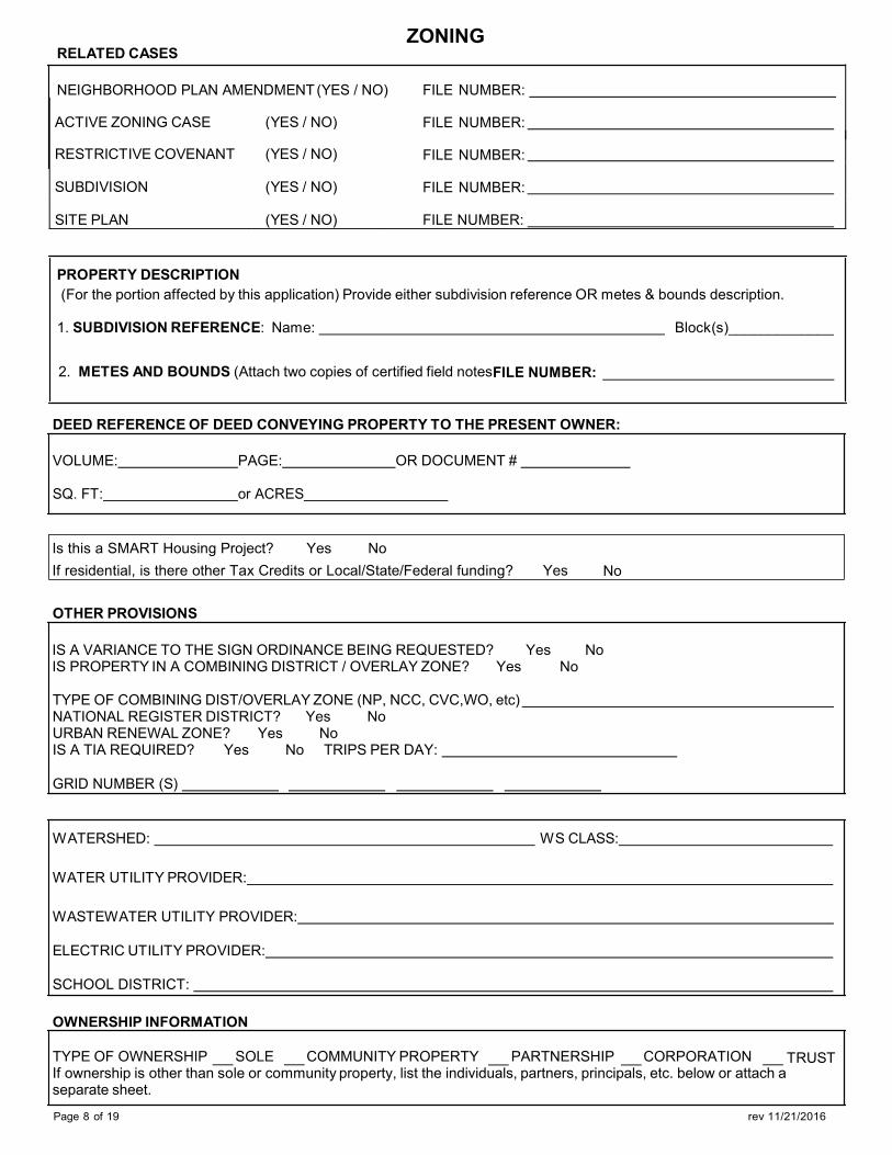
RELATED CASES
NEIGHBORHOOD PLAN AMENDMENT (YES / NO)
ACTIVE ZONING CASE (YES / NO)
RESTRICTIVE COVENANT (YES / NO)
SUBDIVISION (YES / NO)
SITE PLAN (YES / NO)
FILE NUMBER:
FILE NUMBER:
FILE NUMBER:
FILE NUMBER:
FILE NUMBER:
PROPERTY DESCRIPTION (For the portion affected by this application) Provide either subdivision reference OR metes & bounds description.
1. SUBDIVISION REFERENCE: Name: Block(s)_____________
2. METES AND BOUNDS (Attach two copies of certified field notesFILE NUMBER:
DEED REFERENCE OF DEED CONVEYING PROPERTY TO THE PRESENT OWNER:
VOLUME: PAGE: OR DOCUMENT #
SQ. FT: or ACRES
Is this a SMART Housing Project? Yes No If residential, is there other Tax Credits or Local/State/Federal funding? Yes No
OTHER PROVISIONS
IS A VARIANCE TO THE SIGN ORDINANCE BEING REQUESTED? Yes No IS PROPERTY IN A COMBINING DISTRICT / OVERLAY ZONE? Yes No
TYPE OF COMBINING DIST/OVERLAY ZONE (NP, NCC, CVC,WO, etc) NATIONAL REGISTER DISTRICT? Yes No URBAN RENEWAL ZONE? Yes No IS A TIA REQUIRED? Yes No TRIPS PER DAY:
GRID NUMBER (S)
WATERSHED: WS CLASS:
WATER UTILITY PROVIDER:
WASTEWATER UTILITY PROVIDER:
ELECTRIC UTILITY PROVIDER:
SCHOOL DISTRICT:
OWNERSHIP INFORMATION
TRUST TYPE OF OWNERSHIP SOLE COMMUNITY PROPERTY PARTNERSHIP CORPORATION If ownership is other than sole or community property, list the individuals, partners, principals, etc. below or attach a separate sheet.

ZONING
Page 9 of 19 rev 11/21/2016
OWNER INFORMATION
SIGNATURE:
NAME:
FIRM NAME:
TELEPHONE NUMBER:
STREET ADDRESS:
CITY/STATE/ZIP:
AGENT / PRINCIPAL CONTACT (If applicable)
SIGNATURE:
NAME:
FIRM NAME:
TELEPHONE NUMBER:
STREET ADDRESS:
CITY/STATE/ZIP
CONTACT PERSON: TELEPHONE NUMBER:

ZONING
Page 9 of 19 rev 11/21/2016
CITY OF AUSTIN TRAFFIC IMPACT ANALYSIS (TIA) DETERMINATION WORKSHEET
APPLICANT MUST FILL IN W ORKSHEET PRIOR TO SUBMITTING FOR TIA DETERMINATION
PROJECT NAME:
LOCATION:
APPLICANT:
APPLICATION STATUS: DEVELOPMENT ASSESSMENT:
TELEPHONE NO:
ZONING: SITE PLAN:
EXISTING: FOR OFFICE USE ONLY TRACT NUMBER
TRACT ACRES
BLDG SQ.FT. ZONING LAND USE L.T.E CODE TRIP RATE TRIPS PER DAY
PROPOSED FOR OFFICE USE ONLY TRACT NUMBER
TRACT ACRES
BLDG SQ.FT. ZONING LAND USE L.T.E CODE TRIP RATE TRIPS PER DAY
ABUTTING ROADWAYS FOR OFFICE USE ONLY STREET NAME PROPOSED ACCESS? PAVEMENT W IDTH CLASSIFICATION
FOR OFFICE USE ONLY
A traffic impact analysis is required. The consultant preparing the study must meet with a transportation planner to discuss the scope and requirements of the study before beginning the study.
A traffic impact analysis is NOT required. The traffic generated by the proposal does not exceed the thresholds established in the Land Development Code.
The traffic impact analysis has been waived for the following reason:
A neighborhood traffic analysis will be performed by the City for this project. The applicant may have to collect existing traffic counts. See a transportation planner for information.
REVIEW ED BY: DATE:
DISTRIBUTION: FILE CAP. METRO TXDOT TRANS. REV. TRAVIS CO. TRANS DEPT.
TOTALCOPIES:
NOTE: A TIA determination must be made prior to submittal of any zoning or site plan application, therefore, this completed and reviewed form MUST ACCOMPANY any subsequent application for the IDENTICAL project. CHANGES to the proposed project will REQUIRE a new TIA determination to be made.

ZONING
Page 10 of 19 rev 11/21/2016
SUBMITTAL VERIFICATION
My signature attests to the fact that the attached application package is complete and accurate to the best of my knowledge. I understand that City staff review of this application is dependent upon the accuracy of the information provided and that any inaccurate or inadequate information provided by me/my firm/etc., may delay the review of this application.
PLEASE TYPE OR PRINT NAME BELOW SIGNATURE AND INDICATE FIRM REPRESENTED, IF APPLICABLE.
Signature Date
Name (Typed or Printed)
Firm
INSPECTION AUTHORIZATION
As owner or authorized agent, my signature authorizes staff to visit and inspect the property for which this application is being submitted.
PLEASE TYPE OR PRINT NAME BELOW SIGNATURE AND INDICATE FIRM REPRESENTED, IF APPLICABLE.
Signature Date
Name (Typed or Printed)
Firm

ZONING
Page 11 of 19 rev 11/21/2016
ACKNOWLEDGMENT FORM concerning
Subdivision Plat Notes, Deed Restrictions Restrictive Covenants
I, have checked the subdivision plat notes, (Print name of applicant)
deed restrictions, and/or restrictive covenants prohibiting certain uses and/or requiring certain development restrictions i.e. height, access, screening etc. on this property, located at:
(Address or Legal Description)
If a conflict should result with the request I am submitting to the City of Austin due to subdivision plat notes, deed restrictions, and/or restrictive covenants, it will be m y responsibility to resolve it. I also acknowledge that I understand the implications of use and/or development restrictions that are a result of a subdivision plat notes, deed restrictions, and/or restrictive covenants.
I understand that if requested, I must provide copies of any and al l subdivision plat notes, deed restrictions, and/or restrictive covenants as information which may apply to this property.
(Applicant's signature) (Date)
POSTPONEMENT POLICY ON
ZONING HEARINGS
æ Sets a postponement date and time at the City Council hearing so that renotification of residents and property owners is not necessary.
æ Limits the time a hear ing can be pos tponed to two months for both proponents and opponent s, unless otherwise approved by Council so that renotification of residents and property owners is not necessary. æ Allows only one postponement for either side, unless otherwise approved by Council. æ Requires that all requests for postponements be submitted in writing to the director of the Planning and Zoning
Department at least one week prior to the scheduled Council meeting. The written request must specify reasons for the postponement.
æ The Director of the Planning and Zoning Department shall provide a recommendation regarding the validity of the postponement request as the Director deems appropriate. æ Eliminates the automatic granting of a postponement of the first request. æ Authorizes Council to consider requests that are not submitted timely.
Council action December 12, 1996

ZONING
H. Identification of any waivers from City ordinances or development standards pursuant to Chapter 25-2-402.
Page 12 of 19 rev 11/21/2016
PLANNED UNIT DEVELOPMENTS
General Overview Planned Unit Development district zoning is intended to produce development that implements the goals of preserving the natural environment, encouraging high quality development and innovative design, and ensuring adequate public facilities and services. The City Council intends PUD district zoning to produce development that achieves these goals to a greater degree than, and is therefore superior to, development under conventional zoning and subdivision regulations.
SUBMITTAL REQUIREMENTS
æ A Development Assessment must be submitted, a Master Staff Report received, and a Council briefing must occur prior to submittal of a PUD application.
æ Eighteen (18) copies of a 24 x 36 i nch generalized land use map which shall include the following: project name, legal description, boundary lines with bearings and dimensions, total acreage, north arrow, scale and location map.
æ Existing topography using USGS or City datum at two (2) foot intervals for the property and adjacent property with 100 feet of the project boundary.
æ A Mylar will be required prior to finalization of ordinance. æ Eighteen (18) copies of the proposed site development regulations to be established by the Land Use Plan.
Maps, exhibits and support materials, clearly indicating the following, shall be included in either or both of the above:
A. Existing and/or proposed land uses. Identify for each phase and for the total development:
1. Residential: Maximum density, total number and type(s) of unit(s)*, minimum lot size, building height, minimumsetbacks and maximum impervious coverage. For multifamily uses, also show maximum FAR. If structures areproposed in excess of sixty (60) feet in height, schematic drawings shall be provided which illustrate the height,bulk and location of such buildings and line-of-sight analyses from adjoining properties and/or rights-of-way.
2. Non-Residential: Type of uses*, maximum FAR, total square footage, maximum impervious coverage, minimumsetbacks and maximum building height. If structures are proposed in excess of sixty (60) feet in height, schematicdrawings shall be pr ovided which illustrate the height, bulk and l ocation of such buildings and line-of-sightanalyses from adjoining properties and/or rights-of-way.
3. Parkland/Open Space: Location and acreage of land proposed to be dedicated to the public and/or private parks,open space or buffer areas.
4. Civic Uses: Types of uses*, maximum FAR, total square footage, maximum impervious coverage, maximumbuilding height and minimum setbacks.
Uses shall be listed at a level of detail sufficient for Traffic Impact Analysis review as required in Article III,Section 25-6 of the Land Development Code.
C. Environmental characteristics of the site, such as, but not limited to, 100-year and 25 -year floodplains, slopes,environmentally sensitive areas and protected areas as defined in applicable watershed ordinances.
D. The phasing of the development and t he manner in which each phase can exist as a s table independent unitconsistent with the provision of adequate public facilities and services.
E. The location of collector and arterial roadways proposed within the development, right-of-way widths, the location ofaccess points to abutting streets and roadways and a Traffic Impact Analysis, if required by Article III of Chapter 25-6.(The number of copies of the required TIA will be determined by Transportation Review.)
F. Identification of existing major street setbacks and planned right-of-way lines as required in the Austin Roadway Plan.
G. Proposed method of providing the following services:1. Water service including gallons per day requirement.2. Wastewater disposal including gallons per day generated.3. Preliminary stormwater management analysis.4. Location of all required or proposed public facilities.

ZONING
Page 13 of 19 rev 11/21/2016
I. Copies of all covenants and restrictions which provide for the maintenance and taxation of all common areas.
ADDITIONAL SUBMITTAL REQUIREMENTS A written description describing how the proposal meets the intent and purposes of the PUD Zoning District, including Tier One and Tier Two Requirements, and Development Bonuses, as outlined in City Code Chapter 25-2, Subchapter B, Article 2, Division 5, Section 1.1 through Section 2.5.7 and defined below:
§ 2.3. TIER ONE REQUIREMENTS.2.3.1. Minimum Requirements. All PUDs must:
A. meet the objectives of the City Code;
B. provide for development standards that achieve equal or greater consistency with the goals in Section 1.1(General Intent) than development under the regulations in the Land Development Code;
C. provide a total amount of open space that equals or exceeds 10 percent of the residential tracts, 15 percent ofthe industrial tracts, and 20 percent of the nonresidential tracts within the PUD, except that:
1. a detention or filtration area is excluded from the calculation unless it is designed and maintained as anamenity; and
2. the required percentage of open space may be reduced for urban property with characteristics that makeopen space infeasible if other community benefits are provided;
D. comply with the City's Planned Unit Development Green Building Program;
E. be consistent with applicable neighborhood plans, neighborhood conservation combining district regulations,historic area and landmark regulations, and compatible with adjacent property and land uses;
F. provide for environmental preservation and protection relating to air quality, water quality, trees, buffer zonesand greenbelt areas, critical environmental features, soils, waterways, topography, and the natural andtraditional character of the land;
G. provide for public facilities and services that are adequate to support the proposed development includingschool, fire protection, emergency service, and police facilities;
H. exceed the minimum landscaping requirements of the City Code;
I. provide for appropriate transportation and mass transit connections to areas adjacent to the PUD district andmitigation of adverse cumulative transportation impacts with sidewalks, trails, and roadways;
J. prohibit gated roadways;
K. protect, enhance and preserve areas that include structures or sites that are of architectural, historical,archaeological, or cultural significance; and
L. include at least 10 acres of land, unless the property is characterized by special circumstances, includingunique topographic constraints.
2.3.2. Additional Requirements. In addition to the requirements contained in Section 2.3.1 (Minimum Requirements), a PUD containing a retail, commercial, or mixed use development must:
A. comply with Chapter 25-2, Subchapter E (Design Standards And Mixed Use).
B. inside the urban roadway boundary depicted in Figure 2, Subchapter E, Chapter 25-2 (Design Standards andMixed Use), comply with the sidewalk standards in Section 2.2.2., Subchapter E, Chapter 25-2 (Core TransitCorridors: Sidewalks And Building Placement); and
C. contain pedestrian-oriented uses as defined in Section 25-2-691(C)(Waterfront Overlay District Uses) on thefirst floor of a multi-story commercial or mixed use building

Page 14 of 19 rev 11/21/2016
ZONING
§ 2.4. TIER TWO REQUIREMENTS.
This section contains criteria for determining the extent to which development proposed for a PUD district would be superior to that which would occur under conventional zoning and subdivision regulations as required under Section 1.1 (General Intent). A proposed PUD need not address all criteria in this section to achieve superiority, and the council may consider any other criteria the council deems appropriate.
Open Space Provides open space at least 10% above the requirements of Section 2.3.1.A. (Minimum Requirements). Alternatively, within the urban roadway boundary established in Figure 2 of Subchapter E of Chapter 25-2 (Design Standards and Mixed Use), provide for proportional enhancements to existing or planned trails, parks, or other recreational common open space in consultation with the Director of the Parks and Recreation Department.
Environment Does not request exceptions to or modifications of environmental regulations.
Provides water quality controls superior to those otherwise required by code.
Uses innovative water quality controls that treat at least 25 percent additional water quality volume and provide 20 percent greater pollutant removal, in addition to the minimum water quality volume required by code.
Provides water quality treatment for currently untreated, undeveloped off-site areas with a drainage area of at least 25 percent of the subject tract.
Reduces impervious cover or single-family density by five percent below the maximum otherwise allowed by code or includes off-site measures that lower overall impervious cover within the same watershed by five percent below that allowed by code.
Provides minimum 50-foot setback for unclassified waterways with a drainage area of five acres or greater.
Provides at least a 50 percent increase in the minimum waterway and critical environmental feature setbacks required by code.
Clusters impervious cover and disturbed areas in a manner that preserves the most environmentally sensitive areas of the site that are not otherwise protected.
Provides pervious paving for at least 50 percent or more of all paved areas in non-aquifer recharge areas.
Prohibits uses that may contribute to air or water quality pollutants.
Employs other creative or innovative measures.
Austin Green Builder Program
Provides a rating under the Austin Green Builder Program of three stars or above.
Art Provides art approved by the Art in Public Places Program in open spaces, either by providing the art directly or by making a contribution to the City’s Art in Public Places Program or a successor program.

Page 15 of 19 rev 11/21/2016
ZONING
Great Streets Complies with City’s Great Streets Program, or a successor program. Applicable only to commercial, retail, or mixed-use development that is not subject to the requirements of Chapter 25-2, Subchapter E (Design Standards and Mixed Use).
Community Amenities
Provides community or public amenities, which may include spaces for community meetings, day care facilities, non-profit organizations, or other uses that fulfill an identified community need.
Transportation Provides bicycle facilities that connect to existing or planned bicycle routes or provides other multi-modal transportation features not required by code.
Building Design Exceeds the minimum points required by the Building Design Options of Section 3.3.2. of Chapter 25-2, Subchapter E (Design Standards and Mixed Use).
Parking Structure Frontage
In a commercial or mixed-use development, at least 75 percent of the building frontage of all parking structures is designed for pedestrian-oriented uses as defined in Section 25-2-691(C) (Waterfront Overlay District Uses) in ground floor spaces.
Affordable Housing Provides for affordable housing or participation in programs to achieve affordable housing.
Historic Preservation
Preserves historic structures, landmarks, or other features to a degree exceeding applicable legal requirements.
Accessibility Provides for accessibility for persons with disabilities to a degree exceeding applicable legal requirements.
Local Small Business
Provides space at affordable rates to one or more independent retail or restaurant small businesses whose principal place of business is within the Austin metropolitan statistical area.
§ 2.5. DEVELOPMENT BONUSES.2.5.1. Limitation on Development. Except as provided in Section 2.5.2 (Requirements for Exceeding Baseline), site
development regulations for maximum height, maximum floor area ratio, and maximum building coverage in a PUD with residential uses may not exceed the baseline established under Section 1.3.3 (Baseline for Determining Development Bonuses).
2.5.2. Requirements for Exceeding Baseline. Development in a PUD with residential uses may exceed the baseline established under Section 1.3.3 (Baseline for Determining Development Bonuses) for maximum height, maximum floor area ratio, and maximum building coverage if:
A. the application for PUD zoning includes a report approved by the Director of the Neighborhood Housing andCommunity Development Department establishing the prevailing level of affordability of housing in the vicinityof the PUD, expressed as a percentage of median family income in the Austin metropolitan statistical area;and
B. the developer either:
1. provides contract commitments and performance guarantees that provide affordable housing meeting orexceeding the requirements of Section 2.5.3 (Requirements for Rental Housing) and Section 2.5.4(Requirements for Ownership Housing); or
2. makes donations for affordable housing under Section 2.5.6 (Alternative Affordable Housing Options).

Page 16 of 19 rev 11/21/2016
2.5.3.
ZONING
Requirements for Rental Housing. If rental housing units are included in a PUD, at least 10 percent of the rental units or rental habitable square footage within the PUD must:
A. be affordable to a household whose income is less than the affordability level established under Section2.5.5 (Affordability Levels);
B. remain affordable for 40 years from the date a certificate of occupancy is issued; and
C. be eligible for federal housing choice vouchers.
2.5.4. Requirements for Ownership Housing. If owner occupied housing is included in a PUD, at least fivepercent of the owner occupied units or owner occupied habitable square footage within the PUD must be:
A. affordable to a household whose income is less than the affordability level established under Section 2.5.5(Affordability Levels); and
B. transferred to the owner subject to a shared equity agreement approved by the Director of the NeighborhoodHousing and Community Development Department.
2.5.5. Affordability Levels. For purposes of this subchapter, the affordability level is:
A. for a portion of a PUD within the urban roadway boundary depicted in Figure 2 of Subchapter E of Chapter25-2 (Design Standards and Mixed Use), 80% of the median family income in the Austin metropolitanstatistical area;
B. for a portion of a PUD outside the urban roadway boundary depicted in Figure 2 of Subchapter E of Chapter25-2 (Design Standards and Mixed Use), 60% of the median family income in the Austin metropolitanstatistical area; or
C. if the Council finds that the prevailing level of affordability of housing in the vicinity of the PUD is lower thanthe level applicable under Paragraph A or B, any lesser percentage of the median family income in theAustin metropolitan statistical area established by the Council.
2.5.6. Alternative Affordable Housing Options. Development within a PUD may exceed baseline standards asprovided in Section 2.5.2.B.2 (Requirements for Exceeding Baseline) if the developer:
A. donates to the Austin Housing Finance Corporation land within the PUD that is appropriate and sufficient todevelop 20 percent of the residential habitable square footage planned for the PUD, as determined by theDirector of the Neighborhood Housing and Community Development Department; or
B. subject to approval by the city council, donates the amount established under Section 2.5.7 (In Lieu Donation)for each square foot of climate controlled space within the PUD to a Housing Assistance Fund to be used forproducing or financing affordable housing, as determined by the Director of the Neighborhood Housing andCommunity Development Department.
2.5.7. In Lieu Donation. The amount payable under Section 2.5.6.B (Alternative Affordable Housing Options) shallbe 60 percent of the fee established under Section 25-2-586(I) (Affordable Housing Incentives in a CentralBusiness District or Downtown Mixed Use Zoning District) or any successor fee established under the AustinDowntown Plan.

Page 17 of 19 rev 11/21/2016
EXHIBIT VIII
EDUCATIONAL IMPACT STATEMENT (EIS) DETERMINATION PART A
If your project is located in one or more of the following school districts, and requires Land Use Commission review; and meets one of the requirements listed below, an Educational Impact Statement is required.
□ YES □ NO 100 or more single family units are proposed
□ YES □ NO 200 or more multifamily units are proposed
□ YES □ NO 100 or more multifamily units are proposed and a tax credit is requested
□ YES □ NO project will demolish more than 50 residential existing units in a structure more than 20 years old
Please check the appropriate school district(s).
Austin Independent School District
Leander Independent School District
Pflugerville Independent School District
Hays County Independent School District
Del Valle Independent School District
Round Rock Independent School District
Manor Independent School District
If an Educational Impact Statement (EIS) is required, please complete the Educational Impact Analysis (EIA) Part B.

Page 18 of 19 rev 11/21/2016
ZONING
EDUCATIONAL IMPACT ANALYSIS FORM Part B
OFFICE USE ONLY
CASE MANAGER:
APPLICANT / AGENT:
CASE NUMBER:
PROJECT NAME:
PROJECT ADDRESS:
PROPOSED USE:
EXISTING RESIDENTIAL UNITS
Existing number of Residential Units:
Number of existing residential units to be demolished:
Age of units to be demolished:
PROPOSED DEVELOPMENT
Gross Project Acreage:
Number of l ots:
Lots per acre:
PROPOSED RESIDENTIAL UNITS
Proposed number : of Residential Units:
Size of proposed units in square feet (specify range):
Number of bedrooms per unit:
to

Page 19 of 19 rev 11/21/2016
ZONING
ESTIMATED SELLING / RENTAL PRICE (EXISTING AND PROPOSED) Estimated selling price of units (specify range):
Estimated rental rates (if applicable):
toRange of monthly rental rates to be demolished:
Estimated i ncrease in rental rates (specify percentage of i ncrease):
If project is multifamily, will a tax credit be applied for as part of the Smart HousingTM Program?
Number of Certified Affordable Dwelling Units (Proposed or Existing)
OFF-SITE FAMILY AMENITIES EXISTING WITHIN ONE MILE OF PROJECT (Open to the public – attach location plan)
Recreation Centers:
Public Schools:
PARKLAND DEDICATION Parkland dedication required? □ YES □ NO
If yes, please indicate if applicant plans to request fee in lieu or provide parkland:
Fee: □ YES □ NO
Land: □ YES □ NO
ON-SITE FAMILY AMENITIES PROPOSED Will space be provided for childcare services? YES □ NO □ Unknown at this time
Amount of open space required in acres:
Amount of open space provided in acres:
Other proposed amenities (pools, clubhouse, recreation area):
TRANSPORTATION LINKAGES Closest Public Transit Location:
Pedestrian / Bike Routes:
Parks / Greenbelts:
□
to