Embed Size (px)
Citation preview
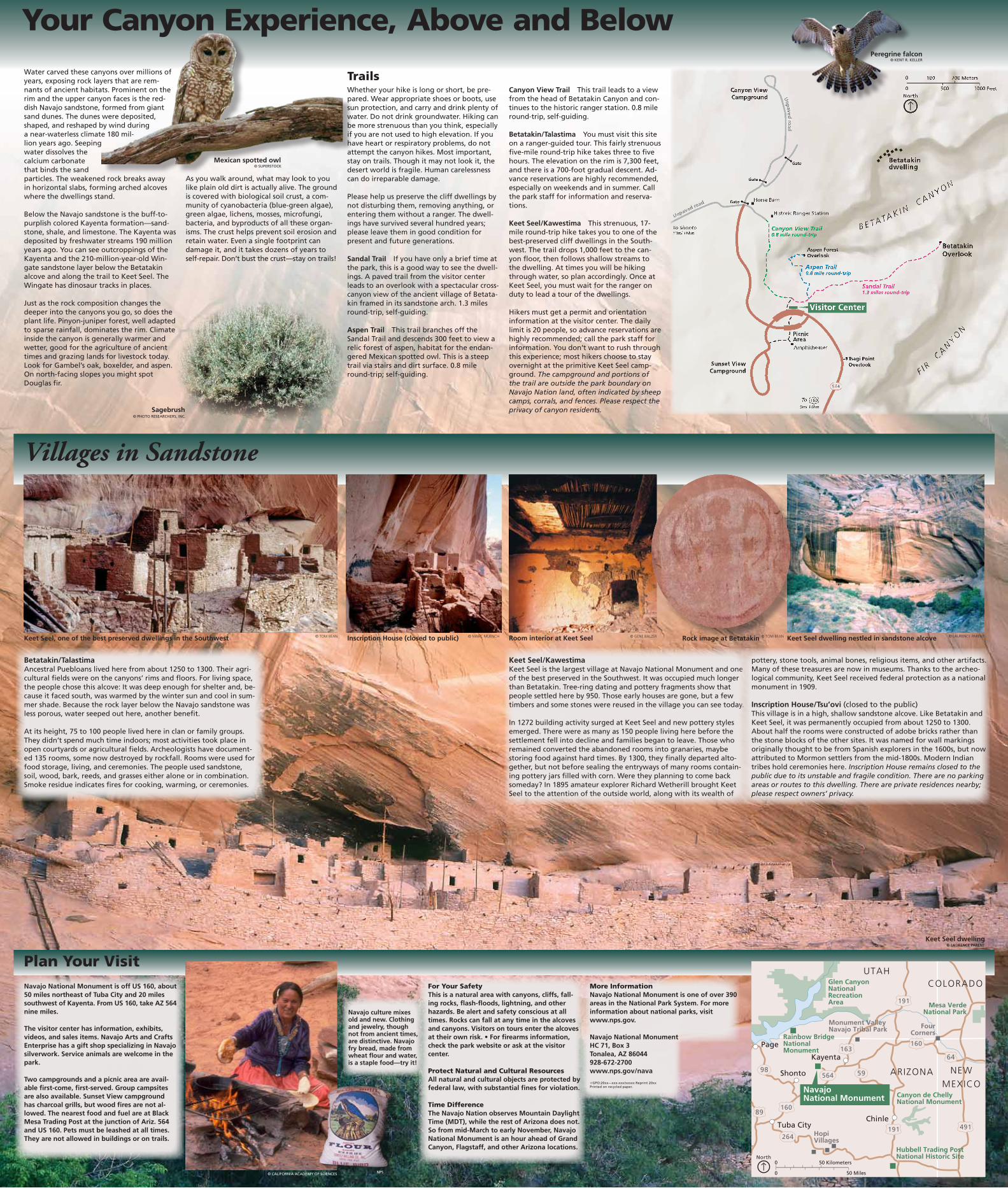
Your Canyon Experience, Above and Below
Keet Seel dwelling nestled in sandstone alcove
Plan Your VisitNavajo National Monument is off US 160, about 50 miles northeast of Tuba City and 20 miles southwest of Kayenta. From US 160, take AZ 564 nine miles.
The visitor center has information, exhibits, videos, and sales items. Navajo Arts and Crafts Enterprise has a gift shop specializing in Navajo silverwork. Service animals are welcome in the park.
Two campgrounds and a picnic area are avail-able first-come, first-served. Group campsites are also available. Sunset View campground has charcoal grills, but wood fires are not al-lowed. The nearest food and fuel are at Black Mesa Trading Post at the junction of Ariz. 564 and US 160. Pets must be leashed at all times. They are not allowed in buildings or on trails.
For Your SafetyThis is a natural area with canyons, cliffs, fall-ing rocks, flash-floods, lightning, and other hazards. Be alert and safety conscious at all times. Rocks can fall at any time in the alcoves and canyons. Visitors on tours enter the alcoves at their own risk. • For firearms information, check the park website or ask at the visitor center.
Protect Natural and Cultural ResourcesAll natural and cultural objects are protected by federal law, with substantial fines for violation.
Time DifferenceThe Navajo Nation observes Mountain Daylight Time (MDT), while the rest of Arizona does not. So from mid-March to early November, Navajo National Monument is an hour ahead of Grand Canyon, Flagstaff, and other Arizona locations.
Villages in Sandstone
Betatakin/TalastimaAncestral Puebloans lived here from about 1250 to 1300. Their agri-cultural fields were on the canyons’ rims and floors. For living space, the people chose this alcove: It was deep enough for shelter and, be-cause it faced south, was warmed by the winter sun and cool in sum-mer shade. Because the rock layer below the Navajo sandstone was less porous, water seeped out here, another benefit.
At its height, 75 to 100 people lived here in clan or family groups. They didn’t spend much time indoors; most activities took place in open courtyards or agricultural fields. Archeologists have document-ed 135 rooms, some now destroyed by rockfall. Rooms were used for food storage, living, and ceremonies. The people used sandstone, soil, wood, bark, reeds, and grasses either alone or in combination. Smoke residue indicates fires for cooking, warming, or ceremonies.
TrailsWhether your hike is long or short, be pre-pared. Wear appropriate shoes or boots, use sun protection, and carry and drink plenty of water. Do not drink groundwater. Hiking can be more strenuous than you think, especially if you are not used to high elevation. If you have heart or respiratory problems, do not attempt the canyon hikes. Most important, stay on trails. Though it may not look it, the desert world is fragile. Human carelessness can do irreparable damage.
Please help us preserve the cliff dwellings by not disturbing them, removing anything, or entering them without a ranger. The dwell-ings have survived several hundred years; please leave them in good condition for present and future generations.
Sandal TraiI If you have only a brief time at the park, this is a good way to see the dwell-ings. A paved trail from the visitor center leads to an overlook with a spectacular cross-canyon view of the ancient village of Betata-kin framed in its sandstone arch. 1.3 miles round-trip, self-guiding.
Aspen Trail This trail branches off the Sandal Trail and descends 300 feet to view a relic forest of aspen, habitat for the endan-gered Mexican spotted owl. This is a steep trail via stairs and dirt surface. 0.8 mile round-trip; self-guiding.
Water carved these canyons over millions of years, exposing rock layers that are rem-nants of ancient habitats. Prominent on the rim and the upper canyon faces is the red-dish Navajo sandstone, formed from giant sand dunes. The dunes were deposited, shaped, and reshaped by wind during a near-waterless climate 180 mil-lion years ago. Seeping water dissolves the calcium carbonate that binds the sand particles. The weakened rock breaks away in horizontal slabs, forming arched alcoves where the dwellings stand.
Below the Navajo sandstone is the buff-to-purplish colored Kayenta formation—sand-stone, shale, and limestone. The Kayenta was deposited by freshwater streams 190 million years ago. You can see outcroppings of the Kayenta and the 210-million-year-old Win-gate sandstone layer below the Betatakin alcove and along the trail to Keet Seel. The Wingate has dinosaur tracks in places.
Just as the rock composition changes the deeper into the canyons you go, so does the plant life. Pinyon-juniper forest, well adapted to sparse rainfall, dominates the rim. Climate inside the canyon is generally warmer and wetter, good for the agriculture of ancient times and grazing lands for livestock today. Look for Gambel’s oak, boxelder, and aspen. On north-facing slopes you might spot Douglas fir.
As you walk around, what may look to you like plain old dirt is actually alive. The ground is covered with biological soil crust, a com-munity of cyanobacteria (blue-green algae), green algae, lichens, mosses, microfungi, bacteria, and byproducts of all these organ-isms. The crust helps prevent soil erosion and retain water. Even a single footprint can damage it, and it takes dozens of years to self-repair. Don’t bust the crust—stay on trails!
Navajo culture mixes old and new. Clothing and jewelry, though not from ancient times, are distinctive. Navajo fry bread, made from wheat flour and water, is a staple food—try it!
Inscription House (closed to public)Keet Seel, one of the best preserved dwellings in the Southwest Rock image at Betatakin
Keet Seel/KawestimaKeet Seel is the largest village at Navajo National Monument and one of the best preserved in the Southwest. It was occupied much longer than Betatakin. Tree-ring dating and pottery fragments show that people settled here by 950. Those early houses are gone, but a few timbers and some stones were reused in the village you can see today.
In 1272 building activity surged at Keet Seel and new pottery styles emerged. There were as many as 150 people living here before the settle ment fell into decline and families began to leave. Those who remained converted the abandoned rooms into granaries, maybe storing food against hard times. By 1300, they finally departed alto-gether, but not before sealing the entryways of many rooms contain-ing pottery jars filled with corn. Were they planning to come back someday? In 1895 amateur explorer Richard Wetherill brought Keet Seel to the attention of the outside world, along with its wealth of
pottery, stone tools, animal bones, religious items, and other artifacts. Many of these treasures are now in museums. Thanks to the archeo-logical community, Keet Seel received federal protection as a national monument in 1909.
Inscription House/Tsu’ovi (closed to the public)This village is in a high, shallow sandstone alcove. Like Betatakin and Keet Seel, it was permanently occupied from about 1250 to 1300. About half the rooms were constructed of adobe bricks rather than the stone blocks of the other sites. It was named for wall markings originally thought to be from Spanish explorers in the 1600s, but now attributed to Mormon settlers from the mid-1800s. Modern Indian tribes hold ceremonies here. Inscription House remains closed to the public due to its unstable and fragile condition. There are no parking areas or routes to this dwelling. There are private residences nearby; please respect owners’ privacy.
Room interior at Keet Seel
Canyon View Trail This trail leads to a view from the head of Betatakin Canyon and con-tinues to the historic ranger station. 0.8 mile round-trip, self-guiding.
Betatakin/Talastima You must visit this site on a ranger- guided tour. This fairly strenuous five-mile round-trip hike takes three to five hours. The elevation on the rim is 7,300 feet, and there is a 700-foot gradual descent. Ad-vance reservations are highly recommended, especially on weekends and in summer. Call the park staff for information and reserva-tions.
Keet Seel/Kawestima This strenuous, 17-mile round-trip hike takes you to one of the best-preserved cliff dwellings in the South-west. The trail drops 1,000 feet to the can-yon floor, then follows shallow streams to the dwelling. At times you will be hiking through water, so plan accordingly. Once at Keet Seel, you must wait for the ranger on duty to lead a tour of the dwellings.
Hikers must get a permit and orientation information at the visitor center. The daily limit is 20 people, so advance reservations are highly recommended; call the park staff for information. You don’t want to rush through this experience; most hikers choose to stay overnight at the primitive Keet Seel camp-ground. The campground and portions of the trail are outside the park boundary on Navajo Nation land, often indicated by sheep camps, corrals, and fences. Please respect the privacy of canyon residents.
Keet Seel dwelling
Mexican spotted owl© SUPERSTOCK
© MARC MUENCH © LAURENCE PARENT
© LAURENCE PARENT
© TOM BEAN © GENE BALZER © TOM BEAN
Peregrine falcon© KENT R. KELLER
© CALIFORNIA ACADEMY OF SCIENCES NPS
Sagebrush© PHOTO RESEARCHERS, INC.
More InformationNavajo National Monument is one of over 390 areas in the National Park System. For more information about national parks, visit www.nps.gov.
Navajo National MonumentHC 71, Box 3Tonalea, AZ 86044928-672-2700www.nps.gov/nava
✩GPO:20xx—xxx-xxx/xxxxx Reprint 20xxPrinted on recycled paper.