Embed Size (px)
Citation preview
Habitats Wyoming Game and Fish Department Introduction
Wyoming State Wildlife Action Plan - 2017 Page III – i - 1
Wyoming State Wildlife Action Plan Terrestrial Habitat Types and Aquatic Basins
Introduction Habitat is a general term which means the environment – physical and biological – that provides the necessary food, water, shelter, space, and other items in proximity to meet the seasonal and year around needs of a particular organism or group of organisms. Wyoming contains a diversity of both terrestrial and aquatic habitats. Habitats are typically classified by plant and/or animal assemblages, geographic features, ecological attributes, or a combination of these features. While the goal of classification systems is to make each unit distinct for cataloging information, addressing issues and threats, and proposing conservation strategies, there is considerable overlap between units. Some habitat groupings tend to be geographically well-defined, while others are widely distributed wherever suitable conditions exist.
Threats and potential conservation actions can vary considerably between habitat types. A habitat classification system with the following attributes was determined to best meet the purposes of Wyoming’s State Wildlife Action Plan (SWAP):
1. Identifies habitats with similar flora, fauna, and conservation concerns;
2. Uses a scale consistent with those frequently used in wildlife management;
3. Describes habitats that are easily recognized by the public and policy makers; and
4. Results in a manageable number of habitats for planning purposes.
Features 2 and 3 were considered important for encouraging support for the SWAP and facilitating coordination with existing local, state, and regional wildlife conservation efforts.
Habitat Classification Systems
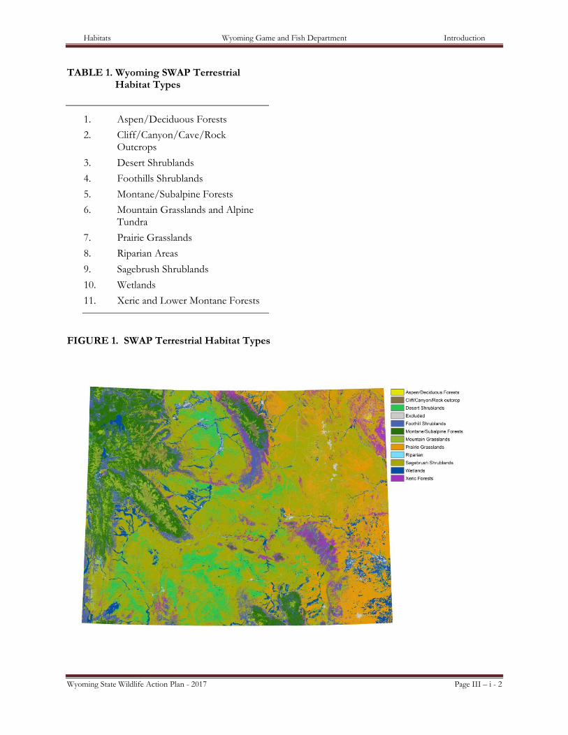
Terrestrial Habitat Types Eleven terrestrial habitat types were included in Wyoming’s SWAP based on the attributes described above (Table 1). The habitat types selected closely resemble major types described by Knight (1994) and NatureServe (2010) (http://www.natureserve.org/explorer).
NatureServe Ecological Systems were then assigned to one of the 11 terrestrial habitat types based on shared characteristics by a group of habitat biologists and ecologists from the WGFD and Wyoming Natural Diversity Database (WYNDD) (Appendix A). NatureServe Ecological Systems were selected because they provide a classification unit that can be readily mapped and that can be easily identified by natural resource managers in the field (Comer et al. 2003). They are defined by biogeographic region, landscape scale, dominant land cover type, and disturbance regimes. Ecological systems are tied to, but not part of, the U.S. National Vegetation Classification (USNVC) (Federal Geographic Data Committee 2008) and can be cross-walked with other classification systems including the WGFD’s Wildlife Observation System types. Ninety-six NatureServe Ecological Systems are found in Wyoming and because the systems have been identified for surrounding states, regional and national assessments and analysis can be applied to conserve wildlife. NatureServe Ecological Systems that are composed primarily of developed lands, were exceedingly small, or do not contain any Species of Greatest Conservation Need (SGCN) were excluded. Information about individual ecological systems discussed in the SWAP can be found at: http://www.natureserve.org/explorer.
Habitats Wyoming Game and Fish Department Introduction
Wyoming State Wildlife Action Plan - 2017 Page III – i - 2
TABLE 1. Wyoming SWAP Terrestrial Habitat Types
1. Aspen/Deciduous Forests
2. Cliff/Canyon/Cave/Rock Outcrops
3. Desert Shrublands
4. Foothills Shrublands
5. Montane/Subalpine Forests
6. Mountain Grasslands and Alpine Tundra
7. Prairie Grasslands
8. Riparian Areas
9. Sagebrush Shrublands
10. Wetlands
11. Xeric and Lower Montane Forests
FIGURE 1. SWAP Terrestrial Habitat Types
Habitats Wyoming Game and Fish Department Introduction
Wyoming State Wildlife Action Plan - 2017 Page III – i - 3
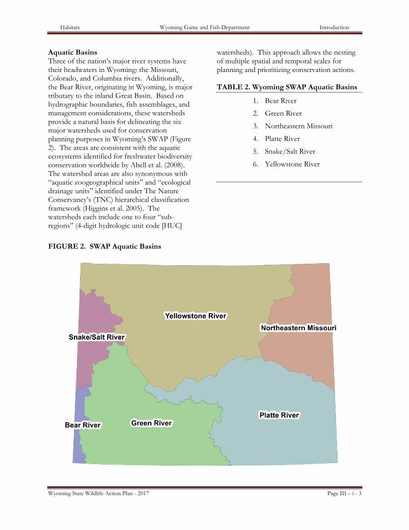
Aquatic Basins Three of the nation’s major river systems have their headwaters in Wyoming: the Missouri, Colorado, and Columbia rivers. Additionally, the Bear River, originating in Wyoming, is major tributary to the inland Great Basin. Based on hydrographic boundaries, fish assemblages, and management considerations, these watersheds provide a natural basis for delineating the six major watersheds used for conservation planning purposes in Wyoming’s SWAP (Figure 2). The areas are consistent with the aquatic ecosystems identified for freshwater biodiversity conservation worldwide by Abell et al. (2008). The watershed areas are also synonymous with “aquatic zoogeographical units” and “ecological drainage units” identified under The Nature Conservancy’s (TNC) hierarchical classification framework (Higgins et al. 2005). The watersheds each include one to four “sub-regions” (4-digit hydrologic unit code [HUC]
watersheds). This approach allows the nesting of multiple spatial and temporal scales for planning and prioritizing conservation actions. TABLE 2. Wyoming SWAP Aquatic Basins
1. Bear River
2. Green River
3. Northeastern Missouri
4. Platte River
5. Snake/Salt River
6. Yellowstone River
FIGURE 2. SWAP Aquatic Basins
Habitats Wyoming Game and Fish Department Introduction
Wyoming State Wildlife Action Plan - 2017 Page III – i - 4
Information Collection Terrestrial Habitat Types Information on leading habitat threats, current conservation initiatives, as well as recommended conservation actions and future monitoring was sought for each terrestrial habitat type from habitat experts within the WGFD and also from experts working outside of the WGFD. Individuals were contacted in agencies and organizations that have significant jurisdictional authority, financial resources, and/or technical expertise regarding each habitat type. This approach was considered to be time-efficient for gathering information, as well as encouraging involvement of entities whose participation is important for implementing the SWAP. Collecting information in this way also fulfills Element 7 of federal SWAP guidelines, which requires “Coordination with federal, state, and local agencies and Indian tribes in developing and implementing the wildlife action plan.”
The input of several habitat experts was compiled and then further supported by independent research. Existing state wildlife conservation plans used by the WGFD were consulted.1 Drafts of each terrestrial habitat type were submitted to habitat experts for review and later to the WGFD’s State Wildlife Terrestrial Habitat Manager. The reviewed habitat types were electronically posted for review by the WGFD’s Nongame Section, Habitat Technical Advisory Group, State Wildlife Action Plan Interagency Advisory Team, and representatives from each agency and organization that had contributed information to at least one of the habitat sections. Near the end of each section is a list
1 Plans included the WGFD’s Strategic Habitat Plan (Wyoming Game and Fish Department 2015), Nongame Bird and Mammal Plan (Wyoming Game and Fish Department 1996), A plan for Bird and Mammal Species of Greatest Conservation Need in Eastern Wyoming Grasslands (Wyoming Game and Fish Department 2006), Wyoming Partners In Flight Wyoming Bird Conservation Plan (Nicholoff 2003), Wyoming Wetlands Conservation Strategy (Wyoming Joint Ventures Steering Committee 2010), and A Conservation Plan for Bats in Wyoming (Hester and Grenier 2005).
of individuals who reviewed the document and provided feedback. Before completion, additional edits were incorporated based on feedback from the WGFD’s Administration, the Wyoming Game and Fish Commission, and the public.
The thoroughness of information and specificity of recommended conservation actions in the sections for each habitat type and aquatic basin vary based upon existing knowledge, the availability of information, and the input provided by section contributors. Individuals providing input were instructed to list only the threats and conservation actions that they believed would have the greatest impact on the habitat type or aquatic basin. As a result, not all issues that may apply to a particular habitat type or aquatic basin are identified, but rather each section provides an overview of the most important issues
Aquatic Basins Information on watershed description, aquatic wildlife, identification of conservation areas, current conservation initiatives, and recommended conservation actions and future monitoring for each aquatic basin were originally developed by four WGFD biologists: the Fish Management Coordinator, Assistant Fish Management Coordinator, Aquatic Habitat Program Manager, and the Assistant Aquatic Habitat Program Manager. Information was gathered by consulting WGFD records and sources as well as other pertinent scientific and government agency sources. The WGFD Strategic Habitat Plan was consulted in some cases for development of conservation areas. Drafts of each basin were electronically posted for review by WGFD Fish Division biologists and the public.
Terrestrial Habitat Type and Aquatic Basin Format Each SWAP habitat type and aquatic basin section is designed to function as a standalone document. This format was adopted because Wyoming’s SWAP is most frequently accessed
Habitats Wyoming Game and Fish Department Introduction
Wyoming State Wildlife Action Plan - 2017 Page III – i - 5
through the internet for information on specific subjects, as opposed to being accessed for the document in its entirety. Additionally, it is likely that individual sections of the SWAP will be duplicated and distributed. This approach resulted in some repeated information between habitat sections since many threats, conservation initiatives, conservation actions, and monitoring activities apply to more than one habitat type or aquatic basin. General descriptions of threats, conservation initiatives, and recommendations are provided along with information specific to the habitat type or aquatic basin. Various sections are frequently cross-referenced throughout the SWAP to provide the reader with additional information on a given topic.
The following subject headings are addressed within each terrestrial habitat type and aquatic basin:
Background This topic heading provides a brief description of the geology, precipitation, vegetation, disturbances, and land uses of each habitat type and aquatic basin.
Maps depicting location Terrestrial maps for the 11 habitat sections were created by displaying the locations of all NatureServe Ecological Systems that comprised a particular habitat type. Maps depicting the aquatic basins were developed in GIS following Habitat Unit Code boundaries. Separate maps were developed to portray conservation priority areas.
Associated SGCN This topic heading lists Wyoming SGCN dependent upon the habitat type or aquatic basin. SGCN may be listed under more than one terrestrial habitat type or aquatic basin. Within the aquatic basin sections, introduced aquatic species, extirpated species, and examples of non-SGCN native species are provided. The lists and discussion include fish, aquatic reptiles, mollusks, clams, and gastropods.
Wildlife This topic heading includes information on: wildlife numbers and species diversity within the habitat or aquatic basin; how the habitat’s structure, function, and ecological processes relate to the wildlife it supports; habitat attributes that are critical to supporting associated SGCN; and non-SGCN wildlife species of high social, ecological, or economic value, including keystone species and game species that are associated with the habitat or aquatic basin.
Threats This topic heading contains primary threats to habitat types or aquatic basins. The threats listed are not intended to be exhaustive, but represent the most significant threats in Wyoming. A description of the general impacts of the threats is provided. Threats were ranked as high, medium, or low in severity based on the input provided by habitat and wildlife experts.
Current conservation initiatives This topic heading lists local, regional, or national efforts to conserve, manage and/or enhance the habitat type or aquatic basin relevant to Wyoming. Efforts that are listed include those that are particularly large in size and scope, address conservation goals, or threats identified within the particular habitat type or aquatic basin.
Recommended conservation actions This topic heading identifies conservation actions that may have the most significant impact for the long-term conservation of each specific habitat type or aquatic basin. Conservation actions are listed in general order of priority. Monitoring activities This topic heading lists activities that are most achievable and effective in determining the quantity and condition of the habitat type or aquatic basin, status of associated SGCN, or the success of the recommended conservation actions.
Habitats Wyoming Game and Fish Department Introduction
Wyoming State Wildlife Action Plan - 2017 Page III – i - 6
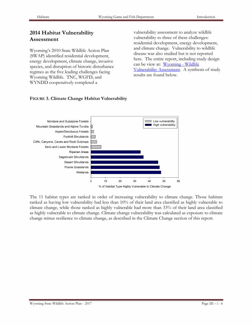
2014 Habitat Vulnerability Assessment Wyoming’s 2010 State Wildlife Action Plan (SWAP) identified residential development, energy development, climate change, invasive species, and disruption of historic disturbance regimes as the five leading challenges facing Wyoming Wildlife. TNC, WGFD, and WYNDD cooperatively completed a
vulnerability assessment to analyze wildlife vulnerability to three of these challenges: residential development, energy development, and climate change. Vulnerability to wildlife disease was also studied but is not reported here. The entire report, including study design can be view at: Wyoming - Wildlife Vulnerability Assessment. A synthesis of study results are found below.
FIGURE 3. Climate Change Habitat Vulnerability
The 11 habitat types are ranked in order of increasing vulnerability to climate change. Those habitats ranked as having low vulnerability had less than 10% of their land area classified as highly vulnerable to climate change, while those ranked as highly vulnerable had more than 33% of their land area classified as highly vulnerable to climate change. Climate change vulnerability was calculated as exposure to climate change minus resilience to climate change, as described in the Climate Change section of this report.

Habitats Wyoming Game and Fish Department Introduction
Wyoming State Wildlife Action Plan - 2017 Page III – i - 7
FIGURE 4. Residential Development Habitat Vulnerability
The 11 habitat types are displayed in order of increasing exposure to current and projected residential development. Exposure to residential development was calculated from 2010 and projected 2030 housing points, as described in the Residential Development section of this report.
FIGURE 5. Oil and Gas Development Habitat Vulnerability
The 11 habitat types are displayed in order of increasing exposure to current and projected oil and gas development. Exposure to oil and gas development was calculated from 2010 and projected 2030 well locations, as described in the Energy Development section of this report.
Habitats Wyoming Game and Fish Department Introduction
Wyoming State Wildlife Action Plan - 2017 Page III – i - 8
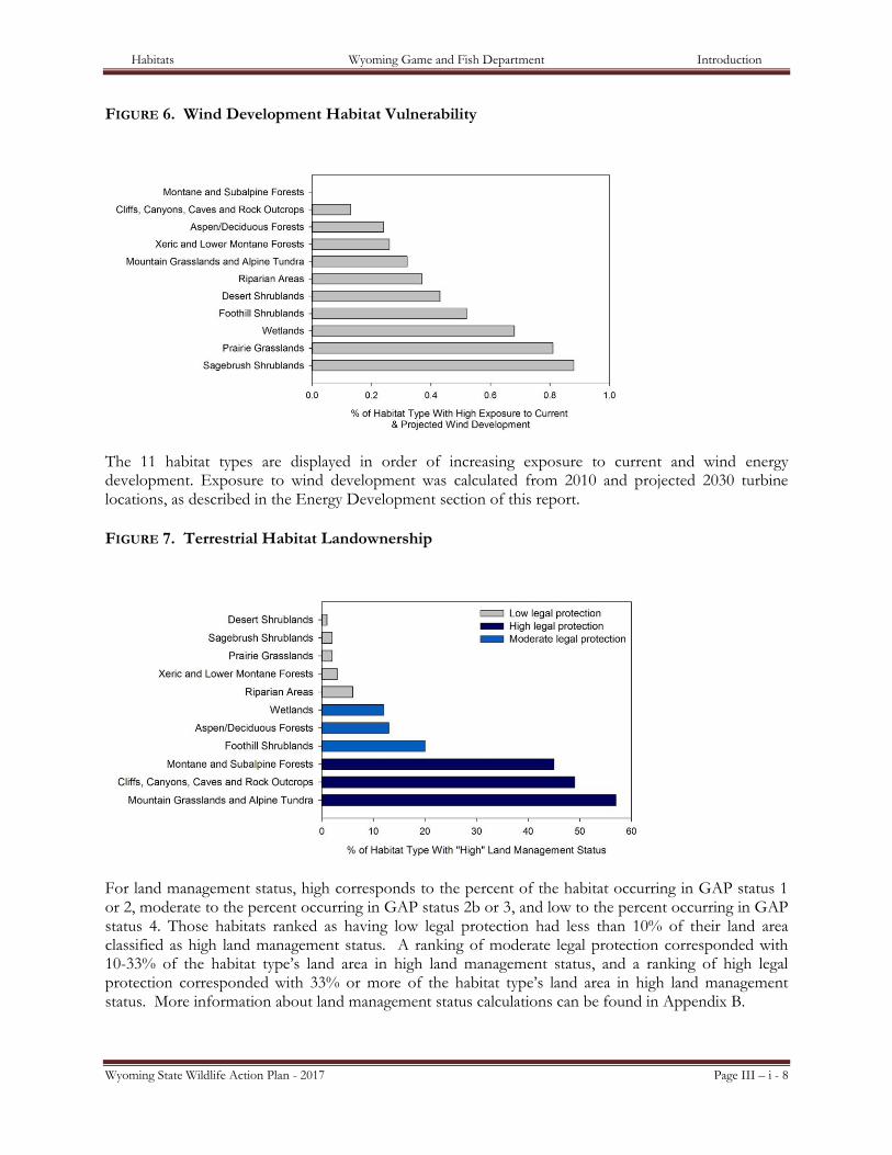
FIGURE 6. Wind Development Habitat Vulnerability
The 11 habitat types are displayed in order of increasing exposure to current and wind energy development. Exposure to wind development was calculated from 2010 and projected 2030 turbine locations, as described in the Energy Development section of this report.
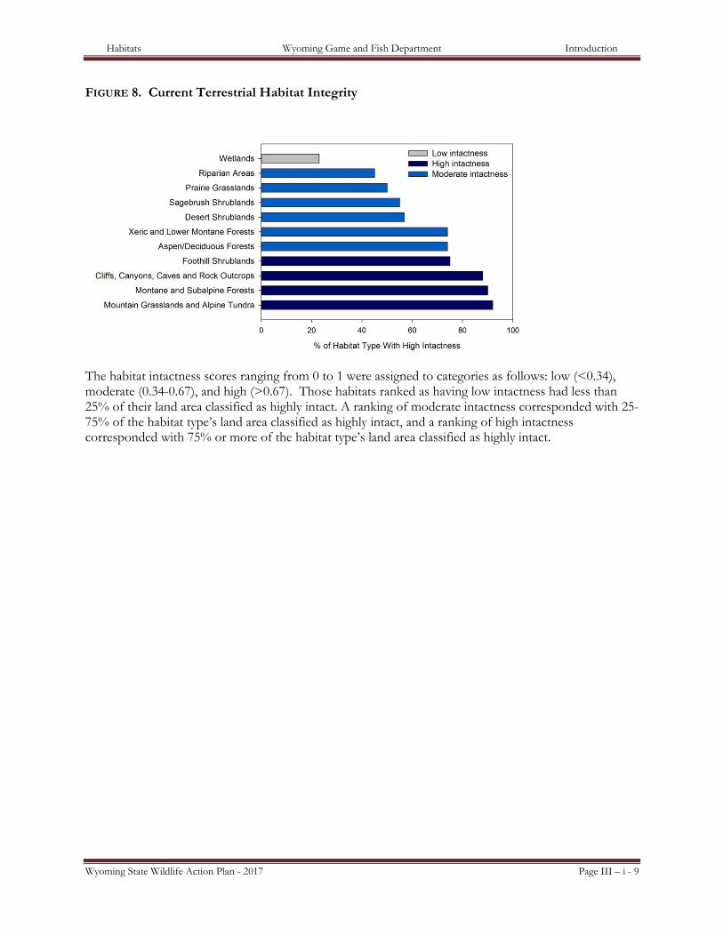
FIGURE 7. Terrestrial Habitat Landownership
For land management status, high corresponds to the percent of the habitat occurring in GAP status 1 or 2, moderate to the percent occurring in GAP status 2b or 3, and low to the percent occurring in GAP status 4. Those habitats ranked as having low legal protection had less than 10% of their land area classified as high land management status. A ranking of moderate legal protection corresponded with 10-33% of the habitat type’s land area in high land management status, and a ranking of high legal protection corresponded with 33% or more of the habitat type’s land area in high land management status. More information about land management status calculations can be found in Appendix B.
Habitats Wyoming Game and Fish Department Introduction
Wyoming State Wildlife Action Plan - 2017 Page III – i - 9
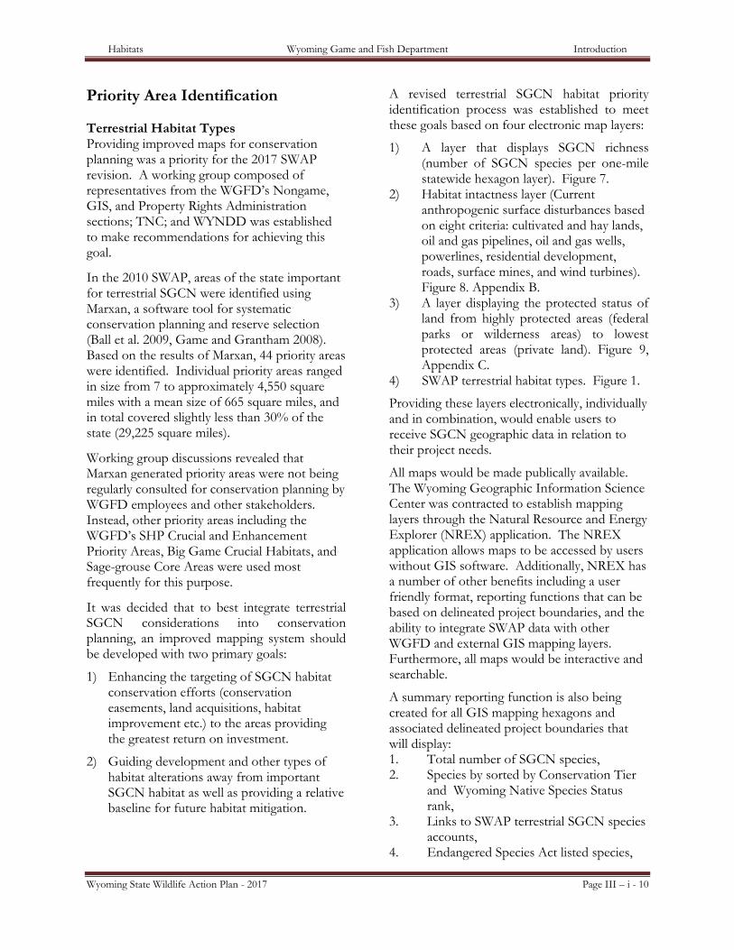
FIGURE 8. Current Terrestrial Habitat Integrity
The habitat intactness scores ranging from 0 to 1 were assigned to categories as follows: low (<0.34), moderate (0.34-0.67), and high (>0.67). Those habitats ranked as having low intactness had less than 25% of their land area classified as highly intact. A ranking of moderate intactness corresponded with 25-75% of the habitat type’s land area classified as highly intact, and a ranking of high intactness corresponded with 75% or more of the habitat type’s land area classified as highly intact.
Habitats Wyoming Game and Fish Department Introduction
Wyoming State Wildlife Action Plan - 2017 Page III – i - 10
Priority Area Identification Terrestrial Habitat Types Providing improved maps for conservation planning was a priority for the 2017 SWAP revision. A working group composed of representatives from the WGFD’s Nongame, GIS, and Property Rights Administration sections; TNC; and WYNDD was established to make recommendations for achieving this goal.
In the 2010 SWAP, areas of the state important for terrestrial SGCN were identified using Marxan, a software tool for systematic conservation planning and reserve selection (Ball et al. 2009, Game and Grantham 2008). Based on the results of Marxan, 44 priority areas were identified. Individual priority areas ranged in size from 7 to approximately 4,550 square miles with a mean size of 665 square miles, and in total covered slightly less than 30% of the state (29,225 square miles).
Working group discussions revealed that Marxan generated priority areas were not being regularly consulted for conservation planning by WGFD employees and other stakeholders. Instead, other priority areas including the WGFD’s SHP Crucial and Enhancement Priority Areas, Big Game Crucial Habitats, and Sage-grouse Core Areas were used most frequently for this purpose.
It was decided that to best integrate terrestrial SGCN considerations into conservation planning, an improved mapping system should be developed with two primary goals:
1) Enhancing the targeting of SGCN habitat conservation efforts (conservation easements, land acquisitions, habitat improvement etc.) to the areas providing the greatest return on investment.
2) Guiding development and other types of habitat alterations away from important SGCN habitat as well as providing a relative baseline for future habitat mitigation.
A revised terrestrial SGCN habitat priority identification process was established to meet these goals based on four electronic map layers:
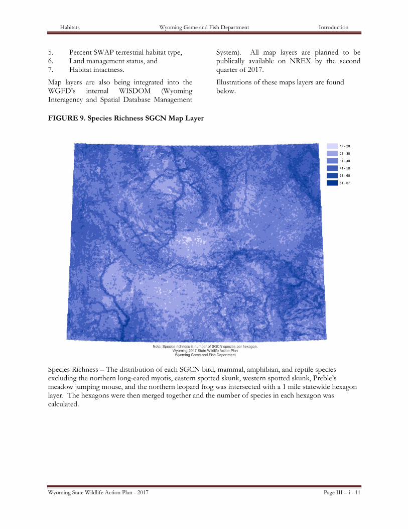
1) A layer that displays SGCN richness (number of SGCN species per one-mile statewide hexagon layer). Figure 7.
2) Habitat intactness layer (Current anthropogenic surface disturbances based on eight criteria: cultivated and hay lands, oil and gas pipelines, oil and gas wells, powerlines, residential development, roads, surface mines, and wind turbines). Figure 8. Appendix B.
3) A layer displaying the protected status of land from highly protected areas (federal parks or wilderness areas) to lowest protected areas (private land). Figure 9, Appendix C.
4) SWAP terrestrial habitat types. Figure 1.
Providing these layers electronically, individually and in combination, would enable users to receive SGCN geographic data in relation to their project needs.
All maps would be made publically available. The Wyoming Geographic Information Science Center was contracted to establish mapping layers through the Natural Resource and Energy Explorer (NREX) application. The NREX application allows maps to be accessed by users without GIS software. Additionally, NREX has a number of other benefits including a user friendly format, reporting functions that can be based on delineated project boundaries, and the ability to integrate SWAP data with other WGFD and external GIS mapping layers. Furthermore, all maps would be interactive and searchable.
A summary reporting function is also being created for all GIS mapping hexagons and associated delineated project boundaries that will display: 1. Total number of SGCN species, 2. Species by sorted by Conservation Tier
and Wyoming Native Species Status rank,
3. Links to SWAP terrestrial SGCN species accounts,
4. Endangered Species Act listed species,
Habitats Wyoming Game and Fish Department Introduction
Wyoming State Wildlife Action Plan - 2017 Page III – i - 11
5. Percent SWAP terrestrial habitat type, 6. Land management status, and 7. Habitat intactness.
Map layers are also being integrated into the WGFD’s internal WISDOM (Wyoming Interagency and Spatial Database Management
System). All map layers are planned to be publically available on NREX by the second quarter of 2017.
Illustrations of these maps layers are found below.
FIGURE 9. Species Richness SGCN Map Layer
Species Richness – The distribution of each SGCN bird, mammal, amphibian, and reptile species excluding the northern long-eared myotis, eastern spotted skunk, western spotted skunk, Preble’s meadow jumping mouse, and the northern leopard frog was intersected with a 1 mile statewide hexagon layer. The hexagons were then merged together and the number of species in each hexagon was calculated.
Habitats Wyoming Game and Fish Department Introduction
Wyoming State Wildlife Action Plan - 2017 Page III – i - 12
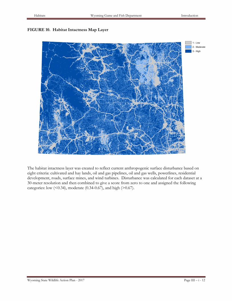
FIGURE 10. Habitat Intactness Map Layer
The habitat intactness layer was created to reflect current anthropogenic surface disturbance based on eight criteria: cultivated and hay lands, oil and gas pipelines, oil and gas wells, powerlines, residential development, roads, surface mines, and wind turbines. Disturbance was calculated for each dataset at a 30-meter resolution and then combined to give a score from zero to one and assigned the following categories: low (<0.34), moderate (0.34-0.67), and high (>0.67).
Habitats Wyoming Game and Fish Department Introduction
Wyoming State Wildlife Action Plan - 2017 Page III – i - 13
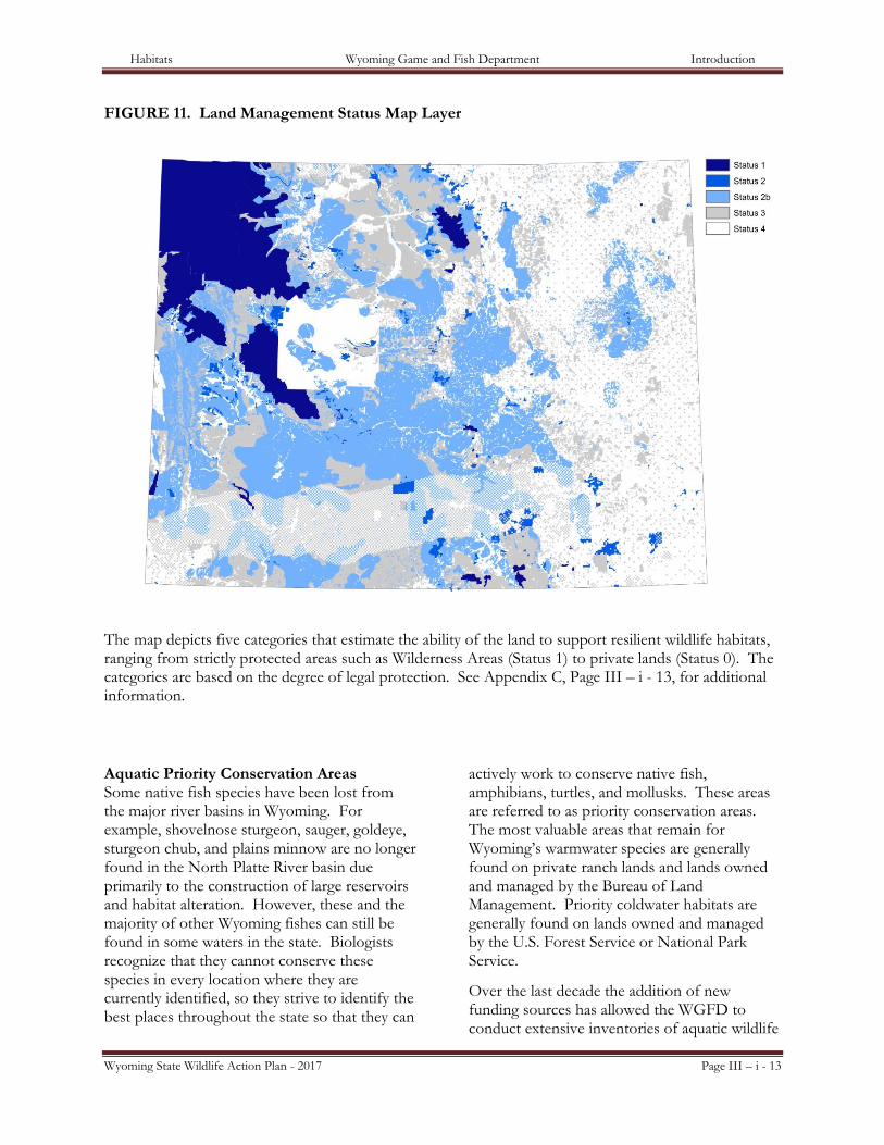
FIGURE 11. Land Management Status Map Layer
The map depicts five categories that estimate the ability of the land to support resilient wildlife habitats, ranging from strictly protected areas such as Wilderness Areas (Status 1) to private lands (Status 0). The categories are based on the degree of legal protection. See Appendix C, Page III – i - 13, for additional information.
Aquatic Priority Conservation Areas Some native fish species have been lost from the major river basins in Wyoming. For example, shovelnose sturgeon, sauger, goldeye, sturgeon chub, and plains minnow are no longer found in the North Platte River basin due primarily to the construction of large reservoirs and habitat alteration. However, these and the majority of other Wyoming fishes can still be found in some waters in the state. Biologists recognize that they cannot conserve these species in every location where they are currently identified, so they strive to identify the best places throughout the state so that they can
actively work to conserve native fish, amphibians, turtles, and mollusks. These areas are referred to as priority conservation areas. The most valuable areas that remain for Wyoming’s warmwater species are generally found on private ranch lands and lands owned and managed by the Bureau of Land Management. Priority coldwater habitats are generally found on lands owned and managed by the U.S. Forest Service or National Park Service.
Over the last decade the addition of new funding sources has allowed the WGFD to conduct extensive inventories of aquatic wildlife
Habitats Wyoming Game and Fish Department Introduction
Wyoming State Wildlife Action Plan - 2017 Page III – i - 14
in the state. These new data have provided a wealth of information in some basins, which has greatly aided in the identification of places for the conservation of Wyoming’s native aquatic wildlife. With this data, biologists are now moving towards management actions to conserve and enhance species within areas identified as priority basins. Additionally biologists are working towards development and refinement of monitoring plans to ensure that WGFD is aware of changes in species abundance that necessitate management intervention.
The priority conservation areas in the SWAP were identified using the best available fish and habitat survey information. These areas generally represent only a fraction of the streams in each basin, but the management of fishes and habitats in these streams is critical to WGFD efforts to conserve Wyoming’s rarest native fishes. Unfortunately, detailed survey information is still lacking for mollusks, and crustaceans. The list of priority conservation areas will likely evolve as the WGFD gains more information about where these species are found and what habitats they require.
Literature Cited
ABELL R, M. L. THIEME, C. REVENGA, M. BRYER, M. KOTTELAT , N. BOGUTSKAYA, B. COAD , N. MANDRAK , E T A. 2008. Freshwater ecoregions of the world: a new map of biogeographic units for freshwater biodiversity conservation. BioScience 58(5):403-414.
BALL, I.R. AND H.P. POSSINGHAM. 2000. Marxan (v1.8.2): Marine Reserve Design Using Spatially Explicit Annealing, A Manual.
BALL, I.R., H.P. POSSINGHAM, AND M. WATTS. 2009. Marxan and relatives: Software for spatial conservation prioritisation. Chapter 14: Pages 185-195 in spatial conservation prioritisation: quantitative methods and computational tools. Eds Moilanen, A., K.A. Wilson, and H.P. Possingham. Oxford University Press, Oxford, UK.
COMER, P., D. FABER-LANGENDOEN, R. EVANS, S. GAWLER, C. JOSSE, G. KITTEL, S. MENARD, M. PYNE, M. REID, K. SCHULZ, K. SNOW, AND J. TEAGUE. 2003. Ecological systems of the United States: A working classification of U.S. terrestrial systems. NatureServe, Arlington, VA.
HESTER, S.G., AND M. B. GRENIER. 2005. A conservation plan for bats in Wyoming. Wyoming Game and Fish Department, Nongame Program, Lander, WY.
HIGGINS, J.V., M.T. BRYER, M.L. KHOURY, T.W. FITZHUGH. 2005. A freshwater classification approach for biodiversity conservation planning. Conservation Biology 19:432-445.
FEDERAL GEOGRAPHIC DATA COMMITTEE
(VEGETATION SUBCOMMITTEE). 2008. National Vegetation classification Standard, Version 2. FGDC-STD-005-2008 (Version 2). available at: http://www.fgdc.gov/standards/projects/FGDC-standards-projects/vegetation/
GAME, E.T. AND H.S. GRANTHAM. 2008. Marxan User Manual: For Marxan version 1.8.10. University of Queensland, St. Lucia, Queensland, Australia, and Pacific Marine Analysis and Research Association, Vancouver, British Columbia, Canada.
Groves, C.R. and The Nature Conservancy 2003. Drafting a conservation blueprint: A practitioner's guide to planning for biodiversity. Island Press, Washington D.C.
GROVES, C.R. D.B. JENSEN, L.L. VALUTIS, K. H. REDFORD, M.L. SHAFFER, J.M. SCOTT, J.V. BAUMGARTNER, J.V. HIGGINS, M.W. BECK, M.G. ANDERSON. 2002. Planning for Biodiversity Conservation: Putting Conservation Science into Practice BioScience 52(6 ):499-512.
KNIGHT, D.H. 1994. Mountains and plains: the ecology of Wyoming landscapes. Yale University Press. 338 pp.
NATURESERVE.. 22001100.. NatureServe, Arlington, Virginia. http://www.natureserve.org/explorer
Habitats Wyoming Game and Fish Department Introduction
Wyoming State Wildlife Action Plan - 2017 Page III – i - 15
NEELY, B., S. KETTLER, J. HORSMAN, C. PRAGUE, R. RONDEAU, R. SMITH, L. GRUNAU, P. COMER, G. BELEW, F. PUSATERI, B. ROSELUND, D. RUNNER, K SOCHI, J. SOVELL, D ANDERSON, T. JACKSON, AND M. KLAVETTER. 2006. Central shortgrass prairie ecoregional assessment and partnership initiative. The Nature Conservancy of Colorado and the Shortgrass Prairie Partnership.
NICHOLOFF, S. H., COMPILER. 2003. Wyoming Bird Conservation Plan, Version 2.0. Wyoming Partners In Flight. Wyoming Game and Fish Department, Lander, WY.
POCEWICZ, A., H. E. Copeland, M. B. Grenier, D. A. Keinath, and L. M. Washkoviak. 2014. Assessing the future vulnerability of Wyoming's terrestrial wildlife species and habitats. The Nature Conservancy, Wyoming Game and Fish Department, Wyoming Natural Diversity Database, Lander, Wyoming.
WYOMING JOINT VENTURES STEERING COMMITTEE. 2010. Wyoming Wetlands Conservation Strategy. Version 1.0. WY Game and Fish Dept., Cheyenne, WY. 109 pp.
WYOMING GAME AND FISH DEPARTMENT. 1996. Nongame Bird and Mammal Plan: a plan for inventories and management of nongame birds and mammals in Wyoming.
_____. 2006. A Plan for Bird and Mammals Species of Greatest Conservation Need in Eastern Wyoming Grasslands. 66pp.
_____. 2015. Strategic Habitat Plan. April 2010. https://wgfd.wyo.gov/Habitat/Habitat-Plans/Strategic-Habitat-Plan. Cheyenne, WY.
Habitats Wyoming Game and Fish Department Introduction
Wyoming State Wildlife Action Plan - 2017 Page III – i - 16
Appendix A
Wyoming State Wildlife Action Plan Terrestrial Habitat Type
NatureServe Ecological System
Mountain Grassland 1. Northern Rocky Mountain Subalpine-Upper Montane Grassland
1. Northern Rocky Mountain Subalpine Deciduous Shrubland
2. Rocky Mountain Alpine Turf 3. Rocky Mountain Alpine Dwarf-Shrubland 4. Rocky Mountain Subalpine-Montane Mesic
Meadow 5. Southern Rocky Mountain Montane-
Subalpine Grassland
Prairie Grasslands
1. Inter-Mountain Basins Semi-Desert Grassland
2. Northern Rocky Mountain Lower Montane, Foothill and Valley Grassland
3. Northwestern Great Plains Mixedgrass Prairie
4. Western Great Plains Foothill and Piedmont Grassland
5. Western Great Plains Sand Prairie 6. Western Great Plains Shortgrass Prairie 7. Introduced Upland Vegetation – Forbland 8. Introduced Upland Vegetation - Annual
Grassland 9. Introduced Upland Vegetation - Perennial
Grassland 10. Recently burned grassland
Sagebrush Shrublands
1. Great Basin Xeric Mixed Sagebrush Shrubland
2. Inter-Mountain Basins Big Sagebrush Shrubland
3. Columbia Plateau Low Sagebrush Steppe 4. Inter-Mountain Basins Big Sagebrush Steppe 5. Inter-Mountain Basins Active and Stabilized
Dune 6. Wyoming Basins Dwarf Sagebrush
Shrubland and Steppe

Habitats Wyoming Game and Fish Department Introduction
Wyoming State Wildlife Action Plan - 2017 Page III – i - 17
Desert Shrublands
1. Western Great Plains Badland 2. Inter-Mountain Basins Shale Badland 3. Northwestern Great Plains Shrubland 4. Inter-Mountain Basins Semi-Desert Shrub-
Steppe 5. Introduced Upland Vegetation - Shrub 6. Inter-Mountain Basins Mat Saltbush
Shrubland 7. Inter-Mountain Basins Mixed Salt Desert
Scrub 8. Inter-Mountain Basins Greasewood Flat
Foothills Shrublands
1. Harvested forest-shrub regeneration 2. Inter-Mountain Basins Mountain Mahogany
Woodland and Shrubland 3. Northern Rocky Mountain Montane-Foothill
Deciduous Shrubland 4. Rocky Mountain Lower Montane-Foothill
Shrubland 5. Western Great Plains Wooded Draw and
Ravine 6. Inter-Mountain Basins Montane Sagebrush
Steppe
Montane/Subalpine Forests
1. Northern Rocky Mountain Subalpine Woodland and Parkland
2. Northern Rocky Mountain Mesic Montane Mixed Conifer Forest
3. Rocky Mountain Lodgepole Pine Forest 4. Rocky Mountain Subalpine Dry-Mesic
Spruce-Fir Forest and Woodland 5. Rocky Mountain Subalpine Mesic-Wet
Spruce-Fir Forest and Woodland 6. Middle Rocky Mountain Montane Douglas-
fir Forest and Woodland 7. Rocky Mountain Poor-Site Lodgepole Pine
Forest 8. Recently burned forest 9. Harvested forest-tree regeneration 10. Harvested forest-grass regeneration 11. Southern Rocky Mountain Mesic Montane
Mixed Conifer Forest and Woodland 12. Harvested forest-grass regeneration
Aspen/Deciduous Forests
1. Rocky Mountain Aspen Forest and Woodland
2. Western Great Plains Dry Bur Oak Forest and Woodland
3. Inter-Mountain Basins Aspen-Mixed Conifer Forest and Woodland
4. Rocky Mountain Bigtooth Maple Ravine Woodland
Habitats Wyoming Game and Fish Department Introduction
Wyoming State Wildlife Action Plan - 2017 Page III – i - 18
Xeric Forests
1. Rocky Mountain Foothill Limber Pine-Juniper Woodland
2. Northern Rocky Mountain Ponderosa Pine Woodland and Savanna
3. Southern Rocky Mountain Ponderosa Pine Woodland
4. Rocky Mountain Subalpine-Montane Limber-Bristlecone Pine Woodland
5. Inter-Mountain Basins Juniper Savanna 6. Northern Rocky Mountain Foothill Conifer
Wooded Steppe 7. Northwestern Great Plains - Black Hills
Ponderosa Pine Woodland and Savanna 8. Southern Rocky Mountain Dry-Mesic
Montane Mixed Conifer Forest and Woodland
Riparian Areas
1. Western Great Plains Floodplain 2. Northern Rocky Mountain Lower Montane
Riparian Woodland and Shrubland 3. Rocky Mountain Lower Montane Riparian
Woodland and Shrubland 4. Great Basin Foothill and Lower Montane
Riparian Woodland and Shrubland 5. Rocky Mountain Subalpine-Montane
Riparian Woodland 6. Rocky Mountain Subalpine-Montane
Riparian Shrubland 7. Northwestern Great Plains Riparian 8. Western Great Plains Riparian Woodland
and Shrubland
Wetlands
1. Open Water 2. Pasture/Hay 3. Inter-Mountain Basins Playa 4. Introduced Riparian and Wetland Vegetation 5. Great Plains Prairie Pothole 6. Rocky Mountain Alpine-Montane Wet
Meadow 7. Western Great Plains Open Freshwater
Depression Wetland 8. North American Arid West Emergent Marsh 9. Columbia Plateau Vernal Pool 10. Rocky Mountain Subalpine-Montane Fen 11. Western Great Plains Closed Depression
Wetland 12. Western Great Plains Saline Depression
Wetland 13. Inter-Mountain Basins Alkaline Closed
Depression 14. Inter-Mountain Basins Interdunal Swale
Wetland
Habitats Wyoming Game and Fish Department Introduction
Wyoming State Wildlife Action Plan - 2017 Page III – i - 19
Cliff/Canyon/Rock Outcrop 1. Rocky Mountain Cliff, Canyon and Massive Bedrock
2. North American Alpine Ice Field 3. Rocky Mountain Alpine Bedrock and Scree 4. Western Great Plains Cliff and Outcrop 5. Inter-Mountain Basins Cliff and Canyon 6. Rocky Mountain Alpine Fell-Field
Excluded 1. Developed, Open Space 2. Developed, Low Intensity 3. Developed, Medium Intensity 4. Developed, High Intensity 5. Quarries, Mines and Gravel Pits 6. Cultivated Cropland 7. Introduced Upland Vegetation - Treed 8. Geysers and Hot Springs

Habitats Wyoming Game and Fish Department Introduction
Wyoming State Wildlife Action Plan - 2017 Page III – i - 20
Appendix B Habitat Intactness Methodology
Intactness – Following methodology outlined in Assessing Tradeoffs in Biodiversity, Vulnerability and Cost when Prioritizing Conservation Sites (Copeland et al. 2007), a cost layer was created to reflect current anthropogenic surface intactness based on eight criteria: cultivated and hay lands, oil and gas pipelines, oil and gas wells, power lines, residential development, roads, surface mines, and wind turbines. Subsections were created that included high/medium urban development, low urban development, tilled agriculture, untilled agriculture, primary/secondary roads, local/primitive roads, active oil and gas wells, inactive oil and gas wells, pipelines, power lines, wind turbines, active mines, inactive mines, and meteorological and cell towers. Each was given a disturbance weight, cutoff distance of impact, and distance decay function based on euclidean distance at a 30-meter resolution. They were then combined to give a score from zero to one and assigned the following categories: 1 or low intactness/high human disturbance (<0.34), 2 or moderate intactness/high human disturbance (0.34-0.67), and 3 or high intactness/high human disturbance (>0.67). Table 3
Impacts Weight Distance Decay
Function Distance Cutoff
Urban Development - High/Medium
500 gradual 2000 m
Urban Development - Low
300 gradual 2000 m
Agriculture - Tilled 300 moderate-abrupt 600 m
Agriculture - Untilled
200 moderate-abrupt 250 m
Roads - Primary/Secondary
500 moderate 1250 m
Roads - Local/Primitive
300 abrupt 250 m
Oil and Gas Wells - active
400 moderate 1250 m
Oil and Gas Wells - inactive
200 moderate-abrupt 600 m
Pipelines 100 abrupt 250 m
Powerlines 200 moderate-abrupt 600 m
Habitats Wyoming Game and Fish Department Introduction
Wyoming State Wildlife Action Plan - 2017 Page III – i - 21
Wind Turbines 400 moderate 1250 m
Surface Mines - active
500 moderate 1250 m
Surface Mines - inactive
300 moderate 600 m
Meteorological Towers and Cell Towers
200 moderate 600 m
References COPELAND H.E., WARD J.M., KIESECKER J.M. 2007 Assessing tradeoffs in biodiversity, vulnerability
and cost when prioritizing conservation sites. Journal of Conservation Planning, 3:1-16
Habitats Wyoming Game and Fish Department Introduction
Wyoming State Wildlife Action Plan - 2017 Page III – i - 22
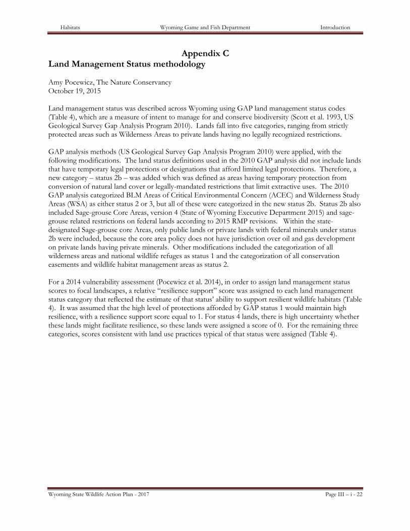
Appendix C Land Management Status methodology Amy Pocewicz, The Nature Conservancy October 19, 2015 Land management status was described across Wyoming using GAP land management status codes (Table 4), which are a measure of intent to manage for and conserve biodiversity (Scott et al. 1993, US Geological Survey Gap Analysis Program 2010). Lands fall into five categories, ranging from strictly protected areas such as Wilderness Areas to private lands having no legally recognized restrictions.
GAP analysis methods (US Geological Survey Gap Analysis Program 2010) were applied, with the following modifications. The land status definitions used in the 2010 GAP analysis did not include lands that have temporary legal protections or designations that afford limited legal protections. Therefore, a new category – status 2b – was added which was defined as areas having temporary protection from conversion of natural land cover or legally-mandated restrictions that limit extractive uses. The 2010 GAP analysis categorized BLM Areas of Critical Environmental Concern (ACEC) and Wilderness Study Areas (WSA) as either status 2 or 3, but all of these were categorized in the new status 2b. Status 2b also included Sage-grouse Core Areas, version 4 (State of Wyoming Executive Department 2015) and sage-grouse related restrictions on federal lands according to 2015 RMP revisions. Within the state-designated Sage-grouse core Areas, only public lands or private lands with federal minerals under status 2b were included, because the core area policy does not have jurisdiction over oil and gas development on private lands having private minerals. Other modifications included the categorization of all wilderness areas and national wildlife refuges as status 1 and the categorization of all conservation easements and wildlife habitat management areas as status 2.
For a 2014 vulnerability assessment (Pocewicz et al. 2014), in order to assign land management status scores to focal landscapes, a relative “resilience support” score was assigned to each land management status category that reflected the estimate of that status’ ability to support resilient wildlife habitats (Table 4). It was assumed that the high level of protections afforded by GAP status 1 would maintain high resilience, with a resilience support score equal to 1. For status 4 lands, there is high uncertainty whether these lands might facilitate resilience, so these lands were assigned a score of 0. For the remaining three categories, scores consistent with land use practices typical of that status were assigned (Table 4).
Habitats Wyoming Game and Fish Department Introduction
Wyoming State Wildlife Action Plan - 2017 Page III – i - 23
Table 4. GAP land management status categories assigned to Wyoming lands and estimates of the probability that each status will support the resilience of wildlife habitats.
GAP status
GAP status definition1 Management designations included
Resilience support score
1 An area having permanent protection from conversion of natural land cover and a mandated management plan in operation to maintain a natural state within which disturbance events (of natural type, frequency, intensity, and legacy) are allowed to proceed without interference or are mimicked through management.
Wilderness Areas, Nature Conservancy Preserves, National Wildlife Refuges, National Parks
1
2 An area having permanent protection from conversion of natural land cover and a mandated management plan in operation to maintain a primarily natural state, but which may receive uses or management practices that degrade the quality of existing natural communities, including suppression of natural disturbance.1
State Wildlife Habitat Management Areas, State Parks, Conservation Easements, TNC fee lands, federal special designations (e.g., research natural area, scenic river)
0.75
2b An area having temporary protection from conversion of natural land cover or legally-mandated restrictions that limit extractive uses (i.e., oil and gas development, wind development, mining).
BLM Areas of Critical Environmental Concern and Wilderness Study Areas, No Surface Occupancy designations, Development stipulations for sage-grouse, including core areas
0.5
3 An area having permanent protection from conversion of natural land cover for the majority of the area, but subject to extractive uses of either a broad, low-intensity type (e.g., logging, OHV recreation) or localized intense type (e.g., mining). It also confers protection to federally listed endangered and threatened species throughout the area.
Publicly-managed lands with management plans in place, including Forest Service, Bureau of Land Management, Bureau of Reclamation, State Trust Lands
0.25
4 There are no known institutional mandates or legally recognized easements or deed restrictions held by the managing entity to prevent conversion of natural habitat types to anthropogenic habitat types. The area generally allows conversion to unnatural land cover throughout or management intent is unknown.
All other lands not assigned a different land management status.
0
References POCEWICZ, A., H.E. COPELAND, M.B. GRENIER, D.A. KEINATH, AND L.M. WASHKOVIAK. 2014.
Assessing the future vulnerability of Wyoming's terrestrial wildlife species and habitats. The
Habitats Wyoming Game and Fish Department Introduction
Wyoming State Wildlife Action Plan - 2017 Page III – i - 24
Nature Conservancy, Wyoming Game and Fish Department, Wyoming Natural Diversity Database, Lander, Wyoming.
SCOTT, J.M., F. DAVIS, B. CSUTI, R. NOSS, B. BUTTERFIELD, C.R. GROVES, H. ANDERSON, S. CAICCO, F. D'ERCHIA, T.C. EDWARDS, J. ULLIMAN, AND R.G. WRIGHT. 1993. Gap Analysis: A geographic approach to protection of biological diversity. Wildlife Monographs 123:3-41.
US GEOLOGICAL SURVEY GAP ANALYSIS PROGRAM. 2010. Protected Areas Database of the United States, Version 1.0.