Embed Size (px)
Citation preview

www.designforhealth.net
Design for HealthSeptember 13, 2007
Health Impact Assessment: Threshold Analysis
Kev
in K
rize
k
Design for Health

www.designforhealth.net
Design for HealthSeptember 13, 2007
Characteristics of the Threshold HIA
• Level III: Most specific in the suite of HIA tools provided by Design for Health.
• Informed by synthesizing and digesting available research. – What does the “research
tells us”– How strong/clear is that
research– How can it be applied to
more specific projects or plan proposals

www.designforhealth.net
Design for HealthSeptember 13, 2007
Where to use in the HIA process?
• Most rapidly evolving of the types of HIAs being developed
• Best used later in the planning process

www.designforhealth.net
Design for HealthSeptember 13, 2007
Structure of the Threshold HIA
• Uses same categories of public health categories as other tools in the Design for Health HIA suite
• Further breaks these areas down into 20 or so specific criteria
• Requires specific knowledge of the plan or project (e.g., specific information or characteristics about plan element or development proposal
• Scoring is based on sliding scale

www.designforhealth.net
Design for HealthSeptember 13, 2007
Other efforts / comparable productsTool
-Healthy Development Tool (San Francisco)
-LEED - ND
-Design for Health
Distinguishing characteristics
-54 categories
-Based on Yes/No
-Very comprehensive
-Based on select studies
-Point based
-70 categories
-Based on select studies
-20 or so specific criteria
-Carefully digests available research
-Focuses on dimensions directly relevant to planning

Topic: AccessibilityTopic: Accessibility - Transit Service (Threshold)
Intent Ensure adequate transit service.
Rationale Transit service not only provides alternatives to auto-travel, but provides means of mobility for the elderly, young and/or financially disadvantaged.
Requirements Residential components of the plan are built at an average of at least 4 (preferably 7) units per gross acre.
Definitions Net acres are often referenced in zoning codes and consider only the developed area. Gross acres refers to the total land area, which may include streets, parks, water features, and other land not used directly for residential or employment-related development.
Submission Site plan with residential (or employment) density calculations.Density calculations based on analysis completed at the block group level or smaller.
CreditsAvailable
9 points: An average of more than 10 residential units / gross acre or more than 50 million sq. ft. commercial/office space in the study area.7 points: 9 units / gross acre or 35-50 million sq. ft. commercial/office space in the study area.4 points: 7 units / gross acre or 8-20 million sq. ft. commercial/office space in the study area.2 points: 4 units / gross acre or 5-8 million sq. ft. self-contained commercial/office space in the study area.
Credits Awarded

www.designforhealth.net
Design for HealthSeptember 13, 2007

Topic: Accessibility - Transit stops (Threshold)
Intent Ensure that residents can conveniently walk to transit service.
Rationale On average, people are willing to walk up to 1200 m (three-quarters of a mile) to access a transit stop.
Requirements All residential or employment areas are located within 1200 m distance of a transit stop with hourly service.
Definitions A transit stop is a bus or train stop with service at least every hour during the daytime on weekdays and weekends. The “walking-transit-shed” area is an area within a 1200 m walk from each transit stop.
Submission Site plan showing the location of transit stops, complete with 1200 m “walking-transit-shed” area highlighted for each stop, This is a street network buffer and can be easily produced using GIS—use the “generalize” buffer in ArcGIS 9.2 and later .
Credits Available
9 points: Entire developed area is shaded within the “walking-transit-shed.”6 points: Fifty-percent of the developed area is shaded within the “walking-transit-shed.”3 points: If there are any transit stops within the study area that run with at least hourly service during the week from 9am-5pm.
Credits Awarded


Topic: Food – Distance to a supermarket or fruit and vegetable shop (Threshold)
Intent Provide access to fruits and vegetables.
Rationale Studies show distances to supermarkets have the clearest effects on health. We also assume that fruit and vegetable stores would have similar benefits.
Requirements
Supermarkets or fruit and vegetable stores within 1600 m (1 mile) of all residential areas.
Definitions A supermarket or fruit and vegetable store is a farmer's market or an establishment with a NAICS code of 445110 or 455230.*
Submission Map showing the location of existing (or proposed) supermarket or fruit and vegetable stores, and a 1600 m network buffer around each (easily done using the “generalize” buffer in ArcGIS 9.2 and later versions).
Credits Available
12 points: Entire developed area is covered by the buffer.8 points: If 50% of the developed area is covered by the buffer.5 points: If 25% of the developed area is covered by the buffer. 1 BONUS point: There is a farmer’s market (during summer months) within the buffer area.
Credits Awarded

www.designforhealth.net
Design for HealthSeptember 13, 2007
Food Stores--NAICS Code Examples
• 445 Food and Beverage Stores
• 4451 Grocery Stores • 44511 Supermarkets and Other Grocery (except
convenience) Stores • 44512 Convenience Stores
• 4452 Specialty Food Stores • 44521 Meat Markets • 44522 Fish and Seafood Markets • 44523 Fruit and Vegetable Markets • 44529 Other Specialty Food Stores
• 445291 Baked Goods Stores
• 445292 Confectionery and Nut Stores
• 445299 All Other Specialty Food Stores
• 4453 Beer, Wine, and Liquor Stores

Design for HealthMay 24, 2007
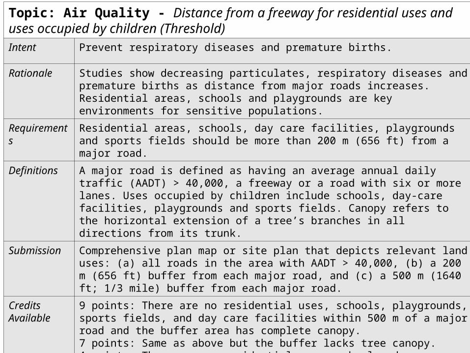
Threshold Analysis (Draft)Topic: Air Quality - Distance from a freeway for residential uses and uses occupied by children (Threshold)Intent Prevent respiratory diseases and premature births.
Rationale Studies show decreasing particulates, respiratory diseases and premature births as distance from major roads increases. Residential areas, schools and playgrounds are key environments for sensitive populations.
Requirements
Residential areas, schools, day care facilities, playgrounds and sports fields should be more than 200 m (656 ft) from a major road.
Definitions A major road is defined as having an average annual daily traffic (AADT) > 40,000, a freeway or a road with six or more lanes. Uses occupied by children include schools, day-care facilities, playgrounds and sports fields. Canopy refers to the horizontal extension of a tree’s branches in all directions from its trunk.
Submission Comprehensive plan map or site plan that depicts relevant land uses: (a) all roads in the area with AADT > 40,000, (b) a 200 m (656 ft) buffer from each major road, and (c) a 500 m (1640 ft; 1/3 mile) buffer from each major road.
Credits Available
9 points: There are no residential uses, schools, playgrounds, sports fields, and day care facilities within 500 m of a major road and the buffer area has complete canopy.7 points: Same as above but the buffer lacks tree canopy.4 points: There are no residential uses, schools, day care facilities, playgrounds, and sports fields within 200 m of a major road.2 bonus points: If there is 50% tree canopy in entire study area.
Credits Awarded

Design for HealthMay 24, 2007

Threshold Analysis (Draft)Topic: Physical Activity – Access to playing areas, parks and trails (Threshold)
Intent To make it easier for people to engage in a variety of activities, potentially increasing physical activity.
Rationale Different people have different ways of being physically active and a variety of environments support such activities.
Requirements Proportion of residential areas located less than 400 m (1/4 mile; 1312 feet) – 600 m (1968 ft) of a neighborhood park or open space.
Definitions Neighborhood parks and open space areas should be publicly accessible and can facilitate active recreation (e.g. walking, cycling, organized games).
Submission Map showing proximity to open spaces and parks that can accommodate active outdoor play with accompanying 400m and 600 m street network buffer around the parks.
Credits Available
6 points: all residences located within the 400 m buffer.3 points: all residences located within the 600 m buffer. 1 point: 50 percent of residences within the 600m buffer.
Credits Awarded

Design for HealthMay 24, 2007

Threshold Analysis (Draft)Topic: Water Quality - Groundwater and drinking-water quality (Threshold)
Intent Prevent groundwater contamination and ensure safe drinking water.
Rationale Public water and sewer systems ensure help ensure the protection of groundwater and drinking water quality, by providing consistent construction and management of infrastructure. Sources of groundwater contamination include proximity to poorly managed septic systems, leaking underground tanks, contamination from landfills, and other forms of polluted surface runoff (nitrogen fertilizers, mining, etc).
Requirements Construct housing in areas that are served by public water and sewer systems.
Definitions Public water and sewer systems are provided and maintained by public entities.
Submission Water and sewer and/or stormwater management plan for the project area or community.
Credits Available
5 points: if developed in a site with existing water and sewer infrastructure or where this is planned to occur with development.1 point: providing a management plan for septic/on-site wastewater systems if development is outside of the seven-county Twin Cities metropolitan area.
Credits Awarded

www.designforhealth.net
Design for HealthSeptember 13, 2007
Threshold Analysis (Draft)- Score sheet
Topic, Threshold or Association Credits availableTotal
credits available
Credits Awarded
Topic: Accessibility 18
Transit service (Threshold) 9 7 4 2 9
Transit stops (Threshold) 9 6 3 9
Topic: Air Quality 18
Distance from a freeway for residential uses and uses occupied by children (Threshold)
9 7 4 2* 9
Polluting uses (Association) 6 6
Air quality mitigation (Association) 3 1 3
Topic: Environmental and Housing Quality
7
Minimize exposure to lead (Association) 7 7
Total Credits--Potential and Awarded 100


![arXiv:1802.07808v2 [cond-mat.mtrl-sci] 5 Apr 2018 · Field e ect enhancement in bu ered quantum nanowire networks Filip Krizek y,1 Joachim E. Sestoft y,1 Pavel Aseev y,2 Sara Marti-Sanchez,](https://img.dokumen.tips/doc/110x75/5c75677409d3f2d3778b7182/arxiv180207808v2-cond-matmtrl-sci-5-apr-2018-field-e-ect-enhancement-in.jpg)


![DO EINSTEIN’S EQUATIONS DESCRIBE REALITY WELL?krizek/cosmol/pdf/B111.pdfK r zek M.: Do Einstein’s equations describe reality well? where r 2[0;r 0] and S is given by Eq. (12)](https://img.dokumen.tips/doc/110x75/5f0cd3ad7e708231d4375342/do-einsteinas-equations-describe-reality-well-krizekcosmolpdfb111pdf-k-r.jpg)