Embed Size (px)
Citation preview

Wurtsmith Air Force Base
173
Case Study Abstract
Wurtsmith Air Force BaseOscoda, Michigan
Site Name and Location:Wurtsmith Air Force BaseOscoda, MI 48750
Geophysical Technologies: Ground penetrating radarElectromagnetic inductionMagnetometry
CERCLIS #MI5570024278
Period of Site Operation:1923 - 1993Operable Unit:OT-16b
Current Site Activities:None
Point of Contact:Paul RekowskiBRAC Environmental CoordinatorAFB Conversion Agency/DDWurtsmith3950 East Arrow StreetOscoda, MI 48750 (517) [email protected]
Geological Setting:Coastal sand plain consisting of 60feet of sand and gravel overlyingglacial-lacustrine silty clays
Technology Demonstrator:William A. Sauck, PhDDepartment of GeosciencesWestern Michigan UniversityKalamazoo, MI 49008(616) [email protected]
Purpose of Investigation:To better explain/define a GPR shadow zone discovered during an earlier geophysical investigation of a well-establisheddissolved hydrocarbon plume to the west. This GPR shadow zone was suspected to be a light non-aqueous phase liquid(LNAPL) plume.
Number of Images/Profiles Generated During Investigation:2700 feet of GPR lines/profiles
Results:The investigation was a complete success and verified the accidental discovery of the newly named OT-16b LNAPL plumefound during a previous GPR investigation of the neighboring FT-02 plume site that was conducted during December 1994. Overall, results indicate that biodegradation of a residual light hydrocarbon product plume and subsequent chemicalprocesses led to changes of the conductivity of soils and groundwater in the capillary fringe. In general, the GPR shadowzone is coincident with the dissolved residual product plume.

Wurtsmith Air Force Base
174
EXECUTIVE SUMMARY
Wurtsmith Air Force Base is located in northeastern Iosco County and covers a 5,223-acre area located onthe northeastern part of Michigan’s lower peninsula, approximately 2 miles west of Lake Huron. The landsurface is a five-mile wide plain bounded on the west by 80-foot high bluffs. Several small streams flowfrom the bluffs and discharge into a swampy area west of the base. The shallow subsurface stratigraphy isknown to consist of uniform and well sorted fine to medium sands that coarsen with depth. A sand andgravel aquifer of glacial origin underlies the base. The water table is about 10 to 12 feet below landsurface at the OT-16b site.
Three non-intrusive geophysical techniques were used in the characterization of a newly discovered plume. These included electromagnetic (EM) induction, ground penetrating radar (GPR), and magnetometry. AnEM survey was chosen to search for any buried metal objects. Magnetometry was used to determine thepresence and location of buried magnetic materials that may have been missed by the EM survey. Due tothe uniform geologic conditions present at the site, GPR was used to further investigate the newlydiscovered plume.
The EM survey identified an unmarked utility line and areas where caution should be exercised whendrilling wells at the site. The magnetometer survey revealed that no unknown buried steel objects existed atthe site. The GPR data identified that the conductive plume is located in the upper portion of the aquifer. Overall, results indicate that biodegradation of a residual light hydrocarbon product plume and subsequentchemical processes led to the generation of a secondary conductive plume in the aquifer. Generally theanomalous GPR zone is coincident with the dissolved product plume.
One of the goals of this investigation was to challenge the conventional model of the geophysical propertiesof hydrocarbon plumes. The conventional model, based on controlled spill and lab experiments, is thatgroundwater and soils contaminated with hydrocarbons exhibit lower electrical conductivity and lowerrelative permittivity than the surrounding uncontaminated media. The alternative model tested in this studyis that hydrocarbon spills in the natural environment will change the impacted zone from electricallyresistive to electrically conductive over time due to biodegradation of the hydrocarbons.
Geophysical methods at the newly-discovered OT-16b site provided coverage of a large area in a shortperiod of time. The geophysical methods were non-intrusive and were less expensive than drilling wellsrandomly or on a grid for plume delineation downgradient from the possible source. The results obtainedfrom the three different techniques were complimentary in making conclusions. The exceptional geologicuniformity of this site provided a uniform background resistivity environment for a geophysicalinvestigation where even a subtle shadow effect could be observed. The conductive nature of this plume,totally derived from insulating hydrocarbon fuels, fits the chemical and electrical model for mature plumesundergoing natural attenuation.
Wurtsmith Air Force Base
175
SITE INFORMATION
Identifying Information
Wurtsmith Air Force BaseOscoda, MI 48750Operable Unit: OT-16bCERCLIS No.: MI5570024278
Background [2, 5, 6]
Physical Description: Wurtsmith Air Force Base (AFB) is located in northeastern Iosco Countyand covers a 5,223-acre area located on the northeastern part of Michigan’s lower peninsula,approximately 2 miles west of Lake Huron. The site is bordered to the north and northeast by VanEtten Lake; to the southeast and east by the Village of Oscoda; to the northwest by State Forestwoodlands, and to the southwest by Allen Lake and wooded marshlands. Approximately 1,943acres of the base are owned by the Air Force, 2,466 acres are leased, and 814 acres are registeredas easement tracts.
The land surface is a five-mile wide plain bounded on the west by 80-foot high bluffs. Severalsmall streams flow from the bluffs and discharge into a swampy area west of the base. The AuSable River, which flows eastward and discharges into Lake Huron, is located less than one milesouth of the base. The land between the base and the river is swampy. The altitude of the landsurface drops from 750 to 580 feet as it slopes toward the river.
The newly discovered OT-16b plume study area where this geophysical investigation took place islocated 450 feet to the east of a former fire training area site known as FT-02, shown in Figure 1.
Site Use: The FT-02 site was used by the Air Force for 24 years as a bi-weekly fire trainingfacility. Typical exercises involved the combustion of several thousand gallons of JP-4 jet fuel andother hydrocarbon fuels. Most but not all of the fuel would burn, which would leave the rest topercolate into the ground along with fire retardant chemicals used to extinguish the fires. In 1982,a concrete fire-containment basin with an oil-water separator was constructed to help reduce theamounts of fuel entering into the subsurface. Until this point, an unknown quantity of fuel hadalready infiltrated into the subsurface. It was reported that overflows persisted after the separatorwas installed in 1982.
Release/Investigation History: Fuels used in the fire training exercises at FT-02 were storednearby in a vaulted underground storage tank (UST) at the OT-16b site. This undergroundcollection and supply tank was removed in 1993, but a concrete pad and steel perimeter posts stillmark its location. The protective vault was free of any signs of hydrocarbon spillage. Therefore,the tank was removed and the vault was backfilled. An underground pipeline had been used totransport the waste fuels and solvents from the collection tank to the burning pad at the center ofthe fire training area (Figure 1). This pipeline passed leak tests at the time it was decommissioned

SITE INFORMATIONWurtsmith Air Force Base
176
Figure 1: Study area location with GPR profile lines shown. The boxed area to the east of the FT-02 plumesite is the OT-16b site. Source: [4, 5].
[6]. Contamination may have occurred in the past from spillage during refilling activities of the UST.
In December of 1994 an integrated geophysical investigation was undertaken at the FT-02 studysite 450 feet to the west of OT-16b. This investigation consisted of ground penetrating radar(GPR), electrical resistivity using dipole-dipole profiling and Schlumberger vertical electricalsounding, and self potential methods [6]. The results of several reconnaissance GPR survey linesconducted to examine the background response of FT-02 revealed several strong reflectors. Onezone of attenuated GPR reflections was spatially correlated with the area of known hydrocarboncontamination, as determined from soil borings and hydrochemical studies [6]. When the positionsof the GPR ‘shadow’ zones were plotted on a map, the resulting pattern was spatially coincidentwith the mapped position of the plume from hydrochemical studies [6]. Some of the ‘shadow’zones were not coincident with the area of the known FT-02 plume (Figure 1) and causedspeculation as to what they represented. The investigator came back in the Spring of 1996 toinitiate this geophysical investigation in the area of the OT-16b site to determine what these other‘shadow’ zones represented.

SITE INFORMATIONWurtsmith Air Force Base
177
Regulatory Context: The site is being addressed through Federal actions. Wurtsmith AFB wasproposed to the National Priorities List (NPL) on January 18, 1994, but its addition to the NPLhas not yet been finalized. In July 1991, the Base Realignment and Closure (BRAC) Commissionrecommended the closure of Wurtsmith AFB. On June 30, 1993, the installation closed asscheduled. The BRAC Cleanup Team (BCT) was formed in fiscal year 1994. The BCT consistsof representatives of the Air Force, U.S. Environmental Protection Agency (EPA) Region 5, andthe Michigan Department of Environmental Quality (MDEQ). The BCT works with a number ofother agencies and organizations to complete environmental actions necessary before property atthe base can be transferred to the private sector.
Site Logistics/Contacts
Federal Lead Agency:United States Air Force
Federal Oversight Agency: EPA Region 5
State Oversight Agency: Michigan Department of EnvironmentalQuality Response DivisionRobert DelaneyP.O. Box 30473Lansing, MI 48909-7973 (517) [email protected]
EPA Remedial Project Manager:Diana MallyU.S. EPA77 West Jackson BoulevardChicago, IL 60604(312) [email protected]
Geophysical Subcontractor: William A. Sauck, PhDDepartment of GeosciencesWestern Michigan UniversityKalamazoo, MI 49008(616) [email protected]
Site Contact:Paul RekowskiBRAC Environmental CoordinatorAFB Conversion Agency/DD Wurtsmith3950 East Arrow StreetOscoda, MI 48750 (517) [email protected]

Wurtsmith Air Force Base
178
MEDIA AND CONTAMINANTS
Matrix Identification
Type of Matrix Sampled and Analyzed: Groundwater and subsurface soil
Site Geology/Stratigraphy [4]
Based on previous borings completed by the United States Geological Survey (USGS) at theneighboring FT-02 site, the shallow subsurface stratigraphy is known to consist of uniform andwell-sorted fine to medium sands that coarsen with depth. A sand and gravel aquifer of glacialorigin underlies the base and is comprised of a brown to gray-brown medium coarse sandcontaining some gravel. The water table is about 10 to 12 feet below land surface at the OT-16bsite. The aquifer overlies a thick clay layer found at an average depth of 65 feet. The clay layer ismostly brown to gray, relatively impermeable, and cohesive. Its thickness at the base is notaccurately known because no lithologic logs exist that extend to the maximum depth of the claylayer. However, the clay is known to be at least 13 feet thick in one location. At Oscoda and atplaces east and north of Van Etten Lake, the clay unit is at least 125 feet thick and may be as thickas 250 feet. It slopes downward to the east at 10 to 30 feet per mile. In general, the surface of theunit dips inward to low points in the northeast part of the base and in an area just northeast of VanEtten Lake. Mississippian sandstone, shale, and limestone formations dipping southwest into theMichigan Basin constitute the bedrock beneath the base.
A groundwater divide cuts diagonally across the base from northwest to southeast. South of thedivide, groundwater flows to the Au Sable River; north of the divide, it flows to Van Etten Creekand Van Etten Lake. Groundwater flow ranges from about 0.8 feet per day in the eastern part ofthe base to about 0.3 feet per day in the western part.
Contaminant Characterization [4]
Primary Contaminant Groups: The primary contaminants of concern at the OT-16b site includefuel related contaminants such as benzene, toluene, ethylbenzene, and xylene (BTEX).
Matrix Characteristics Affecting Characterization Cost or Performance [2, 5]
For the electromagnetic (EM-31) method in the vertical dipole mode, 18 feet is the maximum depthof detection of a highly conductive. Since the contaminant plume found at the site is onlymoderately conductive, approximately 3.3 times the conductivity of the background aquifer, it isnot likely that the EM-31 can effectively discriminate between the weak signature of thecontaminant plume below the water table and the conductivity of the uncontaminated groundwater. The depth of the contaminant plume is below the water table (15 feet), which is close to the limit ofpenetration for the EM-31 instrument. However, results from the EM-31 survey are still useful forother aspects of site characterization, since they clearly indicate where subsurface objects orutilities may exist and caution should be used in drilling future wells at the site. There were no reported characteristics of the site that affected the magnetometer survey results.

MEDIA AND CONTAMINANTSWurtsmith Air Force Base
179
However, there are some limitations when using a magnetometer generally. In a relatively "clean"area, a single drum may be theoretically detected to a depth of 20 feet from the surface. Inpractice, however, numerous smaller, near-surface iron objects will obscure the weaker deep target. A more realistic maximum depth of detection is 5 to 10 feet. Large masses of drums may bedetected easily to depths of 10 to 40 feet.
The clarity of Ground Penetrating Radar (GPR) results can be affected by heterogeneousconditions in the subsurface. However, the study site has been noted to have exceptional geologicuniformity. The results of the GPR survey were enhanced by these uniform conditions.
GEOPHYSICAL INVESTIGATION PROCESS
Investigation Goals
Overall, the goal of this geophysical investigation was to use three different geophysical techniques(GPR, magnetometry, and EM) to explore and better define a suspected light non-aqueous phaseliquid (LNAPL) plume that was encountered during a GPR investigation approximately 450 feet tothe west of the FT-02 plume site [8]. A specific goal of the magnetometer survey was to search forany buried steel objects that might have been missed by the EM induction survey [2, 5]. GPR wasthen used to delineate the boundaries of the newly discovered plume.
One of the goals of this investigation was to challenge the conventional model of geophysicalproperties of hydrocarbon plumes. The conventional model, based on controlled spill and labexperiments, is that groundwater and soils contaminated with hydrocarbons exhibit lower electricalconductivity and lower relative permittivity than the surrounding uncontaminated media. Thealternative model tested in this study is that hydrocarbon spills in the natural environment willchange the impacted volume from electrically resistive to electrically conductive over time due tobiodegradation of the hydrocarbons. Conductivity is enhanced by the leaching of inorganics fromthe soil and aquifer materials by organic acids and carbonic acid produced by microbial activityduring degradation of the hydrocarbons. This model suggests that the conventional model can notbe applied uniformly to all hydrocarbon plume sites and the geoelectrical signature of a plume willvary with time and position [7].
Geophysical Methods [2, 5]
The investigation took place over several days in May 1996. The EM induction method is oftenused to explore for metal objects based on the principle of EM induction. This induction techniqueuses two coils: a transmitter and a receiver. EM surveys detect variations in the conductivity ofsubsurface materials. Buried objects, conductive fluids, and geologic discontinuities can bedetected by artificially applying known electric fields to the ground surface by means of thetransmitter, and the receiver records the presence of disruptions to the known field. Thesedisruptions, termed EM anomalies, can result from geological changes or the presence of metallicobjects, such as pipes, drums, cables, tanks, etc., in the subsurface.

GEOPHYSICAL INVESTIGATION PROCESSWurtsmith Air Force Base
180
For the EM survey, a Geonics EM-31 was carried at waist level using the vertical dipole mode. Agrid of 25 feet by 50 feet was established and results from the survey were plotted using Geosoft™software.
The second method used in this investigation was the magnetometry survey. Magnetometersmeasure variations in the magnetic field of the earth, and local disruptions to the earth’s field, thepresence of naturally occurring ore bodies, and man-made iron or steel objects such as burieddrums, tanks, or ordinance. Whether on the surface or below, iron objects or minerals cause localdistortions or anomalies in this field. Originally designed for mineral exploration, magnetometersare now used in the environmental field for locating buried steel drums, tanks, pipes, and irondebris in trenches and landfills. A magnetometer's response is proportional to the mass of iron inthe target. The magnetometer can only sense ferrous materials such as iron and steel; other metalslike copper, tin, aluminum, and brass are not ferromagnetic and cannot be located with amagnetometer. The effectiveness of magnetometry results can be reduced or inhibited byinterference (noise) from time-variable changes in the earth's field and spatial variations caused bymagnetic minerals in the soil or iron debris, pipes, fences, buildings, and vehicles. Many of theseproblems can be minimized by careful selection of the type of instrument and field procedures usedfor the survey.
Magnetometry was used in this investigation to determine the presence and location of buriedmagnetic materials using a 50 feet by 50 foot grid, which had already been established for the EMsurvey, magnetic data were collected using a Geometrics G-858 cesium vapor magnetometer. Using this data, a magnetic field intensity map of the area was produced for interpretation.
The third geophysical method used in the OT-16b site geophysical investigation was groundpenetrating radar (GPR). GPR uses high-frequency radio waves to determine the presence ofsubsurface objects and structures. A GPR system radiates short pulses of high-frequency EMenergy into the ground from a transmitting antenna. This EM wave penetrates into the ground at avelocity that is related to the electrical properties of subsurface materials. When this waveencounters the interface of two materials having different electromagnetic properties (i.e., soil andwater), a portion of the energy is reflected back to the surface, where it is detected by a receiverantenna and transmitted to a control unit for processing and display. The major principles involvedfor GPR are similar to reflection seismology, except that EM energy is used instead of acousticenergy, and the time scale for GPR is a million times shorter than that of seismic phenomena.
For this investigation a Geophysical Survey Systems, Inc. (GSSI) Subsurface Interface Radar(SIR) System-10 GPR system along with 100 MHZ antennae recording for a scan time of 400nanoseconds (ns) was used. The 100 MHZ Transmitter-Receiver pair were operated with aseparation of 1.45 meters between mid-points. The site was traversed in the west to east and southto north directions along lines spaced 50 feet apart, using a van to tow the antennae. No post-processing was done other than horizontal scales normalization. This GPR system used fixed gainvs. depth function. No gain equalization or automatic gain control processing were used.

Wurtsmith Air Force Base
181
GEOPHYSICAL FINDINGSTechnology Calibration [8]
For the EM-31 the only calibration necessary is setting the zero on the instrument. A region ofvery resistive ground was identified and its conductivity was accurately measured usingconventional techniques. GPR readings were taken in the same location and the instrument gains were set at this point. No further calibration was reported to be necessary for the GPR ormagnetometer used in this investigation.
Investigation Results [2, 5]
The EM survey revealed a linear alignment of anomalies extending from a manhole located atcoordinate S18 to coordinate P12 (Figure 1), and at least three other anomalies parallel to thisalignment. These anomalies were attributed to communication or electric cables buried in theground. No anomalous regions associated with the suspected conductive groundwater plume werevisible on any of the interpretive maps produced from the EM survey. The lack of EM-31response from the conductive plume just below the water table at 15 feet was attributed to theplume being nearly at the limit of depth penetration for the instrument. One unmarked utility linewas discovered. The results indicated where caution should be taken when drilling wells at the site. A strong anomaly beneath the old taxiway in the northeast corner of the map was detected but thesource is unknown.
The magnetic survey revealed that there was a strong low in the magnetic field in the vicinity of theold UST vault. The UST vault (still in place, but now filled) had been surrounded at the surfaceby 20 steel posts filled with concrete. The posts were attached to a flat slab of concrete. Thestrong low was attributed to the potential for the steel having a strong reversed remnantmagnetization. The magnetic survey revealed no other buried steel objects at the site. This was anindicator that the buried cables found by the EM-31 survey are nonmagnetic but electricallyconductive. A strong magnetic low found beneath the asphalt taxiway in the northeast corner ofthe map remains unexplained.
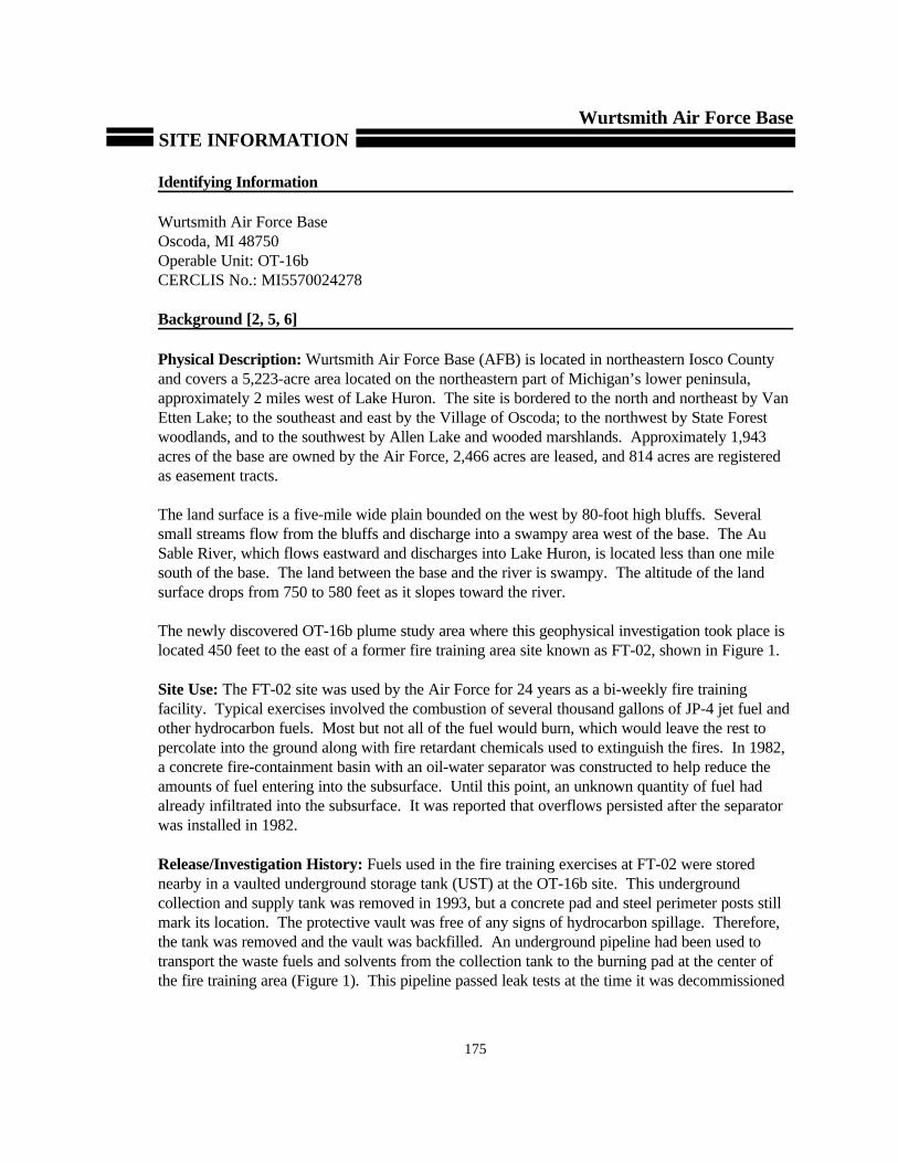
The GPR data revealed that there is a particularly strong reflector representing the water table atapproximately 10 to 12 feet (five meters) shown on Figure 2 as an inverted triangle. This wascaused by the sharp change in the relative permittivity in the transition from unsaturated tosaturated sand. The central areas of the pair of two-dimensional profiles show pronounced signalattenuation, creating an amplitude shadow zone (between “R” and “T” on line 14 in Figure 3, andbetween “S” and “U” on line 16 in Figure 4). The conductive zone causing the attenuation is at thetops of these shadows. The shadow begins at or just below the water table, so the conductiveplume is located in the upper part of the aquifer. This same phenomenon was seen along all otherlines crossing the plume area. This conductive plume in the groundwater below the highly resistivehydrocarbon liquids fits the alternative geoelectrical model proposed for mature plumes [7].
GEOPHYSICAL FINDINGSWurtsmith Air Force Base
182
Figure 2: Ground penetrating radar profile of Line 14 showing the strong amplitude shadow caused by theproximal end of the neighboring FT-02 plume, and the somewhat weaker shadow at the right end caused by theOT-16b plume. Source: [8]
The investigator’s recognition and understanding of the significance of the GPR shadow zonebelow the FT-02 plume led to the discovery of the new contaminant plume. From the shadowzones on the GPR profiles, it was possible to create a map that showed the extent of the conductiveplume at the OT-16b site (Figure 2). The broad proximal end of the plume is possibly due to thespillage of fuel on the asphalt taxiway, as well as possible surface spillage during refillingoperations at the former underground collection tank location. Another result of the GPR
investigation was the observation of some paleo-dune morphologies that underlie the area at adepth of approximately 40 feet (Figure 4 at location “Q”).
Overall, results indicate that biodegradation of a residual light hydrocarbon product plume andsubsequent chemical processes led to the generation of a secondary conductive plume in the aquiferthat is coincident with the dissolved product plume. This coincides with the newly developedhypothesis that hydrocarbon spills in the natural environment cause changes from electricallyresistive to electrically conductive over time due to biodegradation of the hydrocarbon impactedzone. Conductivity is enhanced by the leaching of inorganics from the soil and aquifer materials byorganic acids produced by microbial activity during degradation of the hydrocarbons [7]. Generally the GPR shadow zone is coincident with the dissolved productplume (Figure 2).

GEOPHYSICAL FINDINGSWurtsmith Air Force Base
183
Figure 4: 100 MHZ GPR profile for line 16 oriented with west to the left. Scan length is 400 ns, showingamplitude shadows starting below the water table (about 70 ns or 12 feet); horizontal scale is 50 feetbetween marks. Source: [2, 5]
Figure 3: 100 MHZ GPR profile for line 14 (at 150 feet N coordinate on Figure 1) oriented with west to the left. Scan length is 400 ns, showing amplitude shadows starting below the water table (about 70 ns or 12 feet);horizontal scale is 50 feet between marks. Source: [2, 5]

GEOPHYSICAL FINDINGSWurtsmith Air Force Base
184
Results Validation [2, 5]
Several months after the initial geophysical investigation took place in May of 1996,borings were taken at three locations on the newly discovered OT-16b plume. Soil andgroundwater samples were taken at various depths. One soil sample revealedapproximately 16 inches of a dark, viscous residual hydrocarbon product near the watertable. The conductivities of the aquifer water were at a maximum at the top of thesaturated zone and then diminished to background levels at depths of 10 feet below thewater table. This indicated that the anomalous conductive zone was less than 10 feet thickand the water samples had a conductivity contrast of 2.5 to 3.3 above background levels.
In addition, after the geophysical investigation was completed, a review of WurtsmithAFB air photo archives led to the discovery that a maintenance building occupied the sitearea until the 1970's. The UST was installed later, after the building was removed. Whenthe UST was removed there was no evidence of soil contamination. This indicates that thesource of the newly discovered contaminant plume was probably as a result of thedrainage of solvents and fuels from the floor of the maintenance building.
Wurtsmith Air Force Base
185
LESSONS LEARNED
Lessons learned at the Wurtsmith site include the following:
• Geophysical methods at the newly discovered OT-16b site provided coverage of a largearea in a short period of time. The geophysical methods were non-intrusive and were lessexpensive than drilling wells randomly or on a grid for plume delineation downgradientfrom the possible source. The investigation was considered a complete success and, usingpurely surface geophysical methods, verified the 1994 initial “blind” discovery of a newgroundwater contaminant plume [2, 5].
• The use of more than one geophysical method provided synergy, as each technique wasresponsive to a different property. Therefore, the results obtained using the differenttechniques were complimentary. The GPR outlined the conductive groundwater plume andalso revealed the details of the sand stratigraphy. The shallow EM discovered a complexof buried electrical utility lines where only one line had been previously known. Finally themagnetic survey revealed no buried steel objects, which was helpful in characterizing thesite as “tank-free [2, 5].”
• The conductive nature of this plume, totally derived from insulating hydrocarbon fuels, fitsthe chemical and electrical model for mature plumes undergoing natural attenuation [7]. The anomalous geophysical response is due to the electrically conductive ionic nature ofthe plume, not due to any direct response to residual or dissolved hydrocarbons. Theinvestigators would not extrapolate these results to investigations of dense non-aqueousphase liquid spills [2, 5].
• It is clear that at this site biodegradation of a residual light hydrocarbon product plume andsubsequent chemical processes led to changes of the conductivity of soils and groundwaterin the capillary fringe and underlying aquifer. The broad proximal end of the plume ispotentially due to fuel spillage on the asphalt taxiway, as well as possible surface spillageduring refilling operations at the former underground collection tank location and the floorof the maintenance building [2].
• The exceptional geologic uniformity of this site provided a uniform backgroundenvironment for a geophysical investigation where the shadow effect could be observed [8]. The amplitude shadow is not visible if the GPR scan length or range can only reach thewater table. The shadow will also be destroyed if automatic gain control or other gainequalization is applied during either acquisition or post-processing of data. Therefore theappropriate setting of field acquisition parameters and careful post-processing arenecessary to record and preserve the GPR amplitude shadows [2, 5].

Wurtsmith Air Force Base
186
REFERENCES
1. Baedecker, M.J., Cozzarelli, I.M., Eganhouse, R.P., Siegel, D.I, and Bennett, P.C. CrudeOil in a Shallow Sand and Gravel Aquifer - III. Biogeochemical Reactions and MassBalance Modeling in Anoxic Groundwater; Applied Geochemistry, vol. 8, pp. 569-586. 1993.
2. Bermejo, Jose L., Sauck, William A., and Atekwana, Estella A. Geophysical Discoveryof a New LNAPL Plume at the Former Wurtsmith AFB, Oscoda, Michigan. Fall 1997GWMR Vol XVII, No. 4, pp. 131 to 137.
3. Radian Corporation. Installation Restoration Program--Phase I-Records SearchWurtsmith AFB, Michigan. April 1985.
4. Stark, J.R., Cummings, T.R., and Twenter, F.R. Groundwater Contamination atWurtsmith AFB, Michigan. USGS Water-Resources Investigations Report 83-4002. Prepared in Cooperation with the USAF. 1983.
5. Sauck, William A., Atekwana, Estella A., and Bermejo, Jose L. Characterization of aNewly Discovered LNAPL Plume at Wurtsmith AFB, Oscoda, Michigan. Proceedings ofthe Symposium on the Application of Geophysics to Engineering and EnvironmentalProblems (SAGEEP) 1998 pp. 389-408.
6. Sauck, William A., Atekwana, Estella A., and Nash, Mike S. High ConductivitiesAssociated with an LNAPL Plume Imaged by Integrated Geophysical Techniques. Journal of Environmental and Engineering Geophysics. Volume 2, issue 3, January 1998,p. 203-212.
7. Sauck, William A. A Conceptual Model for the Geoelectrical Response of LNAPLPlumes in Granular Sediments. Proceedings of the Symposium on the Application ofGeophysics to Engineering and Environmental Problems (SAGEEP) 1998 pp. 805-817.
8. Personal Communication with Dr. William A. Sauck of Western Michigan University. November 20, 1998.
9. Personal Communication with Dr. Michael J. Barcelona of the University of Michigan. November 20, 1998.
10. Personal Communication with Phil Sirles of Microgeophysics Corporation. Wheat Ridge,CO. December 10, 1998.