Embed Size (px)
Citation preview

WORLD GEOGRAPHYFourth quarter in geography is spent traveling the world learning about the sevencontinents. Your packet will give you a brief introduction to each continent. If you haveany questions please contact us at any time. We are here to help you when it worksbest for you! Our contact information is listed at the bottom of the page.
Week One: April 27th - May 1stUnit: North AmericaThe Continent of North America: Close-Up - articlePhysical Geography of Mexico, C.A. and Caribbean pg. 71-75Primary Source Reading Activity - National Parks pg. 1-2Geography and History Activity - Panama Canal pg.1-3Unit: South AmericaThe Continent of South America: Close-Up - articlePhysical Geography of the Andes Region pg. 108-11Geography and Economics - Brazilian Land Use pg. 1-2Cultural Geography - Celebrating Carnival pg. 1
Week Two: May 4th - 8thUnit: EuropeThe Continent of Europe: Close-Up - articlePhysical Geography of Western Europe pg. 120-123Geography and Economics - The Banking Crisis of the EU pg.1-2Unit: AfricaThe Continent of Africa: Close-Up - articlePhysical Geography of North Africa pg. 220-223Cultural Geography Activity - The Festival of Replastering pg. 1-2Environmental Case Study - Malaria pg. 1-3
Week Three: May 11th - 15thUnit: AsiaThe Continent of Asia: Close-Up - articlePhysical Geography of East Asia pg. 158-161Physical Geography ofSouthWestAsia pg. 207-210Geography and Economic Activity - Oil Reserves Around the World pg. 1-3Cultural Geography - Anime pg. 1-2

Week Four: May 18th - 22ndUnit: Australia, New Zealand and Oceania
The Continent of Australia: Close-Up - article
Physical Geography of Oceania pg. 293-296
The Aborigines - Article pg. 1-2
The Maori - Article pg. 1-2
Unit: AntarcticaThe Continent of Antarctica: Close-Up - article
Physical Geography of Antarctica pg. 305-308
Geography and History Activity - Antarctic Treaty of 1959 pg. 1-2
Week Five: May 26th - 29th
Final Assessment - World Geography One Pager
We will set up a Google Meet on Tuesday May 26th to share more examples and
answer any questions regarding the final. Be looking for the invite in Google
Classroom. If you don’t have access to Google Classroom, please call or email if
you have questions?
Week Six: June 1st - 5thAll Work Due to the Middle School
Instructions for turning work in will be shared with families closer to the due date.
Teachers will then have this week to grade packets and assign a pass or fail
grade for 4th quarter. Please complete the work to the best of your ability and
contact me or Mr. Turnbull if you have any questions. We are here to help!
ENRlCNIflflT ACTIVIT1SJoin Our *NE\N* Google Classroom! Enrichment activities and challenges posted
weekly. This will be one Google Classroom for all geography students.
dqs4rka
COflTACT INFORINATIODMr. Turnbull Ms. Schmidt
jturnbull(aThayward .kl 2.wi. us [email protected](715) 513-9227

xploring North America The Continent of North America: Close-Up
The Continent of North America: Close-Up
North America is the third largest of the sevenontinents. It includes Canada, the United States, Mex
co, Greenland, the countries of Central America, andhe West Indies Islands. North America covers over,200,000 square miles (23,800,000 sq. km). Together
Nith South America, North America forms the land inNhat is known as the Western Hemisphere.
North America is bordered on the east by the4tlantic Ocean, on the west by the Pacific Ocean, onthe north by the Arctic Ocean and on the south by theGulf of Mexico. It is separated from South America bythe border between Panama and Colombia. Some geographers claim that the Isthmus of Panama actuallydivides the two continents.
The continent’s lowest point is Death Valley, California. It is 282 feet (86 m) below sea level. The highest point is Mount McKinley in Alaska. It is
20,320 feet (6,194 m) above sea level.
Major Regions• The Canadian Shield includes eastern Canada, most of Greenland, and part of the north
ern United States. Part of the region is frozen wasteland, and other parts contain poor soiland large forests.
• A coastal plain covers most of the eastern United States and Mexico.
• The third region is a narrow strip that contains many hills and the Appalachian Mountainsof the United States.
• The fourth region includes the central plain extending from southern Canada to Texasknown as the Great Plains. This region includes most of the continent’s agricultural lands. It
is mainly flat land, but has some hilly regions.
• The fifth region is the western part of the continent and includes the western United States
and Canada and most of Mexico. This region includes the Rocky Mountains of the United
States and Canada and the Sierra Madres of southern California and Mexico.
Major River Systems and Lakes• The Great Lakes and St. Lawrence River drain into the northern Atlantic Ocean. The Mis
sissippi and Missouri Rivers drain most of the central United States and part of southern
Canada into the Gulf of Mexico. The Mackenzie River, which flows into the Arctic Ocean,
drains much of western Canada.
• Most of North America’s lakes are in the northern part of the continent. Lake Superior is theworld’s largest freshwater lake. Other major lakes include the remainder of the Great Lakes:
Erie, Huron, Michigan, and Ontario, as well as Lake Mead on the Colorado River, and theGreat Salt Lake in Utah.
CD-4041 75 ©Mark Twain Media, Inc., Publishers 7

Exploring North America The Continent of North America: Knowledge Check
Name:
_______________
Date: —
Knowledge Check
Matching
1. Isthmus of Panama a. South America and North America form this2. Canadian Shield b. divides North and South America3. coastal plain c. includes eastern Canada, most of Greenland, and4. Western part of the northern United States
Hemisphere d. covers most of the eastern United States and Mexico5. central plain e. extends from southern Canada to Texas
Multiple Choice Did You Know?
6. This is the world’s largest freshwater lake. North America covers just over 16 per-a. Lake Mead cent of the world’s surface, yet has onlyb. Great Salt Lake about eight percent of the world’s popuc. Lake Superior lation.
d. Lake Michigan
7. This region includes most of the continent’sagricultural lands.
a. coastal plainb. Canadian Shieldc. Death Valleyd. Great Plains
---..--. ---—
Constructed ResponseDescribe the difference between the coastal plain region of the North American continent andthe central plain region. Use details from the reading selection to support your answer.
CD-404175 ©Mark Twain Media, Inc., Publishers 9
NAME
___________________________________
DATE
___________
CLASS
_____
/___
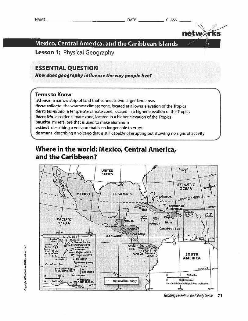
netwrksMexico, Central America, and the Caribbean Islands ---
Lesson 1: Physical Geography
ESSENTIAL QUESTION
How does geography influence the way people live?
Where in the world: Mexico, Central America,
and the Caribbean?
Bermuda(U.K.)
‘a.
ATLANTIC
I OCEAN
— . MEXICO Gulf of Mexico —
-- -
-
. 20SCUBA d REPUBLIC
F Ca>,an ‘
s”nust
GUATEMALA
BELIZE .
‘ JAEA HAITI
/ HONOURAS Caribbean Sea
110’W 1O0W NICARAGUP
_______
ELSALVADOR -.
— )U NBritish Vugi,, / St.Mrtin (Fr)
_________________________
I,la,,d, (U.K.> / / Sr. Muarten (Neth.) •----—_.———
_____________________________
= COSTAPuerto .. 7’BARBUDA RICA
(U.S.) / PANAMA Pna SOUTH—OOMNICA AMERICAt_Martisique (Fr.)
Caribbean Sea IB - 4—ST. LUCIA
StVINCENTAND_. EQUATOR o’—
0
TM: :::NADINES BARBADOS
. 590 intles
I TRINIOAD— National boundar I 0 500 kilometers
NDTOBO ‘ I. LambertAzimulhal Equal Area projection
I 90’W 80 W 70’W 60 W
Reading Essentials and Study Guide 71
Terms to Knowisthmus a narrow strip of land that connects two larger land areastierra caliente the warmest climate zone, located at a lower elevation of the Tropicstierra tempiada a temperate climate zone, located in a higher elevation of the Tropicstierra fria a colder climate zone, located in a higher elevation of the Tropicsbauxite mineral ore that is used to make aluminumextinct describing a volcano that is no longer able to eruptdormant describing a volcano that is still capable of erupting but showing no signs of activity

NAME DATE
___________
CLASS
_____
/
netw@rksMexico, Central America, and the Caribbean Islands .,
Lesson 1: Physical Geography, continued
Physical Geography of Mexico and
Central America
Guiding Question What landforms and waterways do Mexico and
Central America have?
Mexico and Central America form an isthmus, a narrow strip of
land, that connects North and South America. Along with South
America and some Caribbean islands, they make up Latin America.
Spanish and Portuguese are spoken in this region of the Americas.
Both languages are based on Latin, the language of ancient Rome.
Mexico is the largest nation of the region, with about two-thirds
of the land. On the north, it has a long border with the United
States. Two coastal mountain ranges form a backwards y. The Sierra
Madre Occidental is on the west, and the Sierra Madre Oriental is in
the east. There are coastal plains alongside both ranges.
Between the mountain ranges is a high central plateau. The two
ranges join in the Southern Highlands, which form the tail ofthey.
Mountains run down the center of Central America, with narrow
coastal lowlands on both sides.
Mexico and Central America lie along the Ring of Fire that rims
the Pacific Ocean. Volcanoes are common here. The mountains of
the Sierra Madre Occidental are made up of volcanic rock, but
there are no active volcanoes. There are active volcanoes in the
southern part of the Central Plateau and in Central America. The
volcanic rock breaks down to create fertile, productive soil.
Earthquakes are also common along the Ring of Fire.
The Pacific Ocean is on the west side of Mexico and Central
____________________
America. The Gulf of California is an inlet of the Pacific Ocean that
separates Baja California from the rest of Mexico, On the east are
two arms of the Atlantic Ocean. They are the Gulf of Mexico and
the Caribbean Sea.
There are few rivers in the region. Northern Mexico has a dry
climate. The Rio Bravo del Norte is an important river. It is known
as the Rio Grande in the United States. Southern Mexico and
Central America get more rain. The largest lake is Lake Nicaragua
in Nicaragua. The Panama Canal is an important waterway. It was
built in the early 1900s to allow ships to travel between the
Atlantic and Pacific oceans without going around South America.
Most of Mexico and Central America lie in the tropics. Because
they are near the Equator, you might expect that the climate
would be hot. The coastal lowlands are hot, but areas that are
higher up are not. The highlands are much cooler.
Defining
1. What is the definitionof isthmus?
4 Marking the‘ Text
2. Read the text on theright. Highlight thenames of the threemountain ranges thatare found in Mexico.
Explaining
3. What effect does theRing of Fire have onMexico and CentralAmerica?
Marking the‘ Text
4. Read the text on theright. Highlight thenames of the bodies ofwater found in theregion.
II
1,
•0
-4
I
n03
72 Reading Essentials and Study Guide

NAME DATE CLASSN
netwrksMexico, Central America, and the Caribbean Islands .-- )\Lesson 1: Physical Geography, continued
DrawingConclusions
5. Why do most of thepeople in Mexico andCentral America live inthe tierra ternpladaclimate zone7
Marking theText
6 Read the text on theleft Underline thesentences thatdescribe a tropicalwet/dry climate
// Marking the
Text
7. Circle the mineral thatis used to makealuminum.
ReadingProgress Check
Why are differentclimate zones found inthis region, eventhough most of theregion is in the tropics?
Geographers divide nearly all the region into three climatezones based on their elevation, or how high they are. Soil, crops,animals, and climate change from zone to zone.
The tierra caliente (“hot land”) is the warmest zone. Tropicalcrops such as bananas, sugarcane, and rice grow there.
Slightly higher in elevation, the tierra templada (“temperateland”) has a cooler climate. Coffee, corn, and wheat grow well inthis zone and most of the people of the region live there.
At an even higher elevation is the tierra fria (“cold land”), whichhas chilly nights. Hardy crops such as potatoes, barley, and wheatgrow there. Dairy farming is also a major agricultural activity in thisclimate zone.
A fourth zone above this is the tierra helada (“frozen land”),where few human activities take place. However, this climate zoneis more common in other areas of the Americas.
Tirra Helada20’F—55’F (-7’C— 13’C) *
8.
E8z
0’
a.0
Much of Mexico and Central America has a tropical wet/dryclimate. Most of the precipitation falls during the wet summerseason. There is a dry winter season that is longer in areasfarther from the Equator. Fierce hurricanes can strike during thesummer and early fall.
Mexico’s most important resources are oil and natural gas. Theyare found along the coast of the Gulf of Mexico and in the gulfwaters. The Spanish were first attracted to the area’s gold andsilver. Other minerals found here include copper, iron ore, andbauxite, a mineral ore used to make aluminum.
Most of Central America has few mineral resources. Nicaragua isan exception. It has gold, silver, iron ore, lead, zinc, and copper.Guatemala has some oil, and its mountains produce nickel.
Reading Essentials and Study Guide 73

NAME DATE
____________
CLASS
_____
netw®rksMexico, Central America, and the Caribbean Islands ..---‘
Lesson 1: Physical Geography, continued
Four large islands: Cuba, Jamaica,Hispaniola, and Puerto Rico
Dozens of smaller islands, mostlyindependent countries
Independent nation made up of morethan 3,000 islands east of Florida
t
-4
I
Marking theText
9. Read the text on theright. Highlight thenames of the twocountries that sharethe island ofHispaniola.
DrawingConclusions
10. Why do you think thatsome of the islands ofthe Caribbean arecalled the GreaterAntilles, while othersare called the LesserAntilles?
Physical Geography of the CaribbeanIslandsGuiding Question How are the Caribbean islands alike anddifferent from one another?
Hundreds of islands dot the Caribbean Sea. They are home tomore than 30 countries or territories belonging to other countries.Some are large, with millions of people. Others are tiny, and hometo only thousands.
The Caribbean islands can be split into three groups: theGreater Antilles, the Lesser Antilles, and the Bahamas. Each groupcontains many islands.
Defining
11. Howdoextinctvolcanoes differ fromactive volcanoes?
Cuba and Jamaica are independent countries. Hispaniola ishome to two countries. Haiti is located on the west side of theisland, and the Dominican Republic is on the east side. Puerto Ricois a U.S. commonwealth. It has its own government, but thepeople are American citizens.
The Lesser Antilles were once colonies of France, Britain, Spain,or the Netherlands. Now they are independent countries. Theircultures reflect their colonial past.
The Greater Antilles are a mountain chain. Much of thismountain chain is under water. The Lesser Antilles were formed byvolcanoes. Many of these volcanoes no longer erupt because theyare extinct. However, some are only dormant.That means theycould erupt but do not show any signs of being active.
The Caribbean Sea is a western arm of the Atlantic Ocean. Itswarm waters help feed the Gulf Stream, This current carries warmwater up to the eastern coast of the United States. The Caribbeanislands have a tropical wet/dry climate.
Temperatures are high year-round, but ocean breezes make lifecomfortable. Humidity is generally high. Rainfall varies. Someislands can get only 10 inches of rain a year. Others can get as
74 Reading Essentials and Study Guide

NAME DATE CLASS
/
net@rks
much as 350 inches a year. The islands, mostly those in the north,are prone to hurricanes.
The Caribbean Sea is rich in fish. Some are harvested for foodand others are for sport fishing. The islands have little timbertoday, and there are few mineral resources. Some Caribbeanislands have important resources, though. Trinidad and Tobagohave oil and natural gas. The Dominican Republic exports nickel,gold, and silver. Cuba is a major nickel producer. Jamaica has largeamounts of bauxite.
However, the islands’ most important resources are their climateand people. Millions of tourists come each year to enjoy the sandybeaches and warm hospitality.
ReadingProgress Check
12 How did the islands ofI: the Caribbean form?
aE0
LI
x
aLI
WritingCheck for Understanding
1. Informative/Explanatory How is the physical geography of Mexico and Central Americasimilar?
Lesson 1: Physical Geography, continued
2. Informative/Explanatory Why do the islands of the Caribbean Sea have so many differentcultures?
Reading Essentials and Study Guide 75


NAME
_________________________________________
DATE
_______________
CLASS
__________
\/,
Primary Source Reading Skills Activity netw’rksNorth America --‘
National Parks
As people began to explore more areas of the United States in the 1800s,they realized the need to preserve some of the nation’s natural resources,including its natural beauty. The first national park was Yellowstone NationalPark, established in 1 872. Years later, President Theodore Roosevelt felt thatmany more areas of the nation needed to be preserved. He established a lawcalled the Antiquities Act of 1906, which gave presidents the power todesignate sites as national monuments. Roosevelt had a love for theoutdoors and for conservation. He named many areas as national parks andmonuments, such as Crater Lake in Oregon, Mesa Verde in Colorado, and theGrand Canyon in Arizona.
Directions: Read the following statement by Theodore Roosevelt about theimportance of conservation of natural resources.
The conservation of our natural resources and their proper useconstitute the fundamental problem which underlies almost every otherproblem of our national life. We must maintain for our civilization theadequate material basis without which that civilization can not exist. Wemust show foresight. We must look ahead.... There must be a realizationof the fact that to waste, to destroy, our natural resources, to skin andexhaust the land instead of using it to increase its usefulness, will resultin undermining the days of our children the very prosperity which weought by right to hand down to them amplified and developed.
Theodore RooseveltSeventh Annual Message
December 3, 1907
0
0
S.
03
1

NAME
___________________________________________
DATE
________________
CLASS
__________
/Primary Source Reading Skills Activity cont. netw:rksNorth America .-“ )\Analyzing Primary Sources
Directions: After reading about national parks, answer the following
questions.
1. Determining Central Ideas What is the name of the law that gave presidentsthe power to designate sites as national monuments?
2. Determining Central Ideas What was the first national park and when was it
established?
3. Analyzing Primary Sources Why did Roosevelt think that preserving natural
resources was important?
4. Determining Central Ideas Choose a quote from the excerpt that shows that
Theodore Roosevelt was thinking about the future of the country.
Critical Thinking
5. Analyzing What do you think might have happened to some of the preserved
national areas if the national park system had not been created?Ct
0
0
x
C3t
2

NAME
_________________________________________
DATE
_______________
CLASS
__________
// -
Geography and History Activity netwrksNorth America
The Panama Canal
For centuries, to travel by sea from theeastern coast of North America to itswestern coast, seafarers had to sailaround the entire length of SouthAmerica, a trip that took months tocomplete. However, people were awarethat in parts of Central America—atwhat is today Panama—the twooceans were tantalizingly close. Theyknew that a route connecting the twooceans would save thousands of milesof travel, an important considerationfor transporting materials for trade,among other reasons.
The Spanish made the first proposal tolink the oceans through Panama in1524. At that time, the Spanishtransported the gold and silver theytook from their South Americancolonies to Panama City, which lies onthe Pacific Ocean side of Panama. Thento the Atlantic side. The gold and silver were then loaded on to ships boundfor Spain. The king of Spain ordered a survey for a route through Panama, Hewanted to make the trip from Spain to Peru easier, not only to shorten thetrip for the gold and silver, but also to give the Spanish a military advantageover the Portuguese. The king abandoned the plans when the Spanishgovernor in Panama sent an unfavorable report regarding the proposedcanal. The route was not shown to be possible until a Spanish expedition ofthe area from 1 788 to 1 793. However, construction never began.
Then as travel and trade in the Western Hemisphere increased, manycountries became interested once again in Panama as a possible way toshorten the trip. In 1881, a French company made an attempt to buUd acanal through Panama to connect the two oceans. It began by cutting apath from coast to coast, often through dense jungle. Then it began digging,which continued for several years. However, the company never finishedbuilding the canal. It abandoned the effort in 1888 as a result of severalfactors, including flooding and rockslides, disease and death of workers, lackof money, and inexperienced engineers. In 1894, a second French companytook over the equipment and maintenance of the uncompleted work and itsought a buyer for these assets.
Latin America
they used mules to carry the metals
1

NAME
_________________________________________
DATE
_______________
CLASS
__________
‘N /Geography and History Activity cont. netwrk
North America
In 1902 under President Theodore Roosevelt, the United States agreed to
buy the rights to the canal property and equipment from the French. At the
time, Panama was part of Colombia, so the United States needed permission
from Colombia to build the canal across the Panama isthmus. Colombia
turned down the proposal. When angry Panamanian businessmen rose up in
revolution, the United States backed them. They put pressure on Colombia
and got a treaty letting them build the canal. In 1903, as a result of the
treaty, Panama was declared a republic.
United States construction on the canal began in 1904, and the canal
officially opened to world commerce in 1914. The Americans attempted to
address the problems that the French had faced, two of which were malaria
and yellow fever. New advances in medicine had shown that these diseases
are transmitted by mosquitoes. With that knowledge, the United States was
able to follow procedures that made building the canal much safer.
However, workers still faced unexpected rockslides that dramatically
increased the amount of material to be excavated. The total cost of building
the canal is an estimated $375 million. Some 25,000 lives may have been
lost, mostly during the French era.
Today, the canal is widely regarded as a modern wonder of technology. It is
about 50 miles (80 kilometers) long. It takes about nine hours to make the
journey through the canal. As many as 15,000 ships make the journey
through the canal each year.
Applying Geography to History
Directions: Read the information about the Panama Canal and examine the
map. Then answer the questions below.
1. Explaining What is the Panama Canal?
0
tO
0
-4S.I,
‘-40
2

Exploring South America The Continent of South America: Close-Up
The Continent of South America;Close-Up
South America is the fourth-largest of the seven continents. It covers about 6,880,800 square miles(17,821,000 sq. km). It is almost 4,600 miles (7,400 km)ong and about 3,200 miles (5,100 km) across at its widestpoint.
Most of South America is south of the equator. TheTropic of Capricorn nearly bisects the continent. Not only isthe continent south of North America, but most of it lies far-[her east also. Lima, Peru, is one of South America’s mostwestern cities. Yet it is farther east than Miami, Florida.
To the north, the continent is connected to Centraland North America at the Isthmus of Panama. The northernborder is on the Caribbean Sea and the Atlantic Ocean.The eastern border is on the Atlantic Ocean, and the western border is on the Pacific Ocean. South America has many large plains and plateaus. Theseflatlands are used for farming and raising animal herds. The pampas is a fertile plain used by bothfarmers and ranchers. South America has some desert land as well.
in Forest• The continent is also known for its vast rain forest areas, especially along the Amazon River
basin. Ecologists are concerned about the large areas of rain forest lost each year to development.
Rivers, Lakes, and Waterfalls• The Amazon is South America’s longest river and the world’s second-longest river. It be
gins in the Andes Mountains of Peru and travels 4,050 miles (6,518 km) before it emptiesinto the Atlantic Ocean on Brazil’s coastline. Although it is not the world’s longest river, theAmazon has more tributaries (other rivers and streams draining into it), drains more land,and has a greater volume of water than any other river. Other major South American riversinclude the Paraná, Paraguay, and Uruguay Rivers.
• South America does not have many large lakes. Maracaibo is the continent’s largest lake.It covers over 6,300 square miles (16,300 sq. km). TitIcaca is the world’s highest navigablelake at an altitude of 12,500 feet (3,810 m). It is in the Andes on the border between Peruand Bolivia.
• South America has many spectacular waterfalls. Angel Falls in Argentina is the world’shighest waterfall.
Mountains• The Andes make up the world’s longest mountain range. The range stretches about 4,500
miles (7,240 km) along the entire western side of South America. Many of the Andes peaksare over 20,000 feet (6,096 m) high. Only the Himalayas of Asia are higher.
• Aconcagua, in Argentina, is the Western Hemisphere’s highest point. It is over 22,800 feet(6,950 m) above sea level.
- ‘
: -.
\,r
I
--
CD-404176 ©Mark Twain Media, Inc., Publishers 7
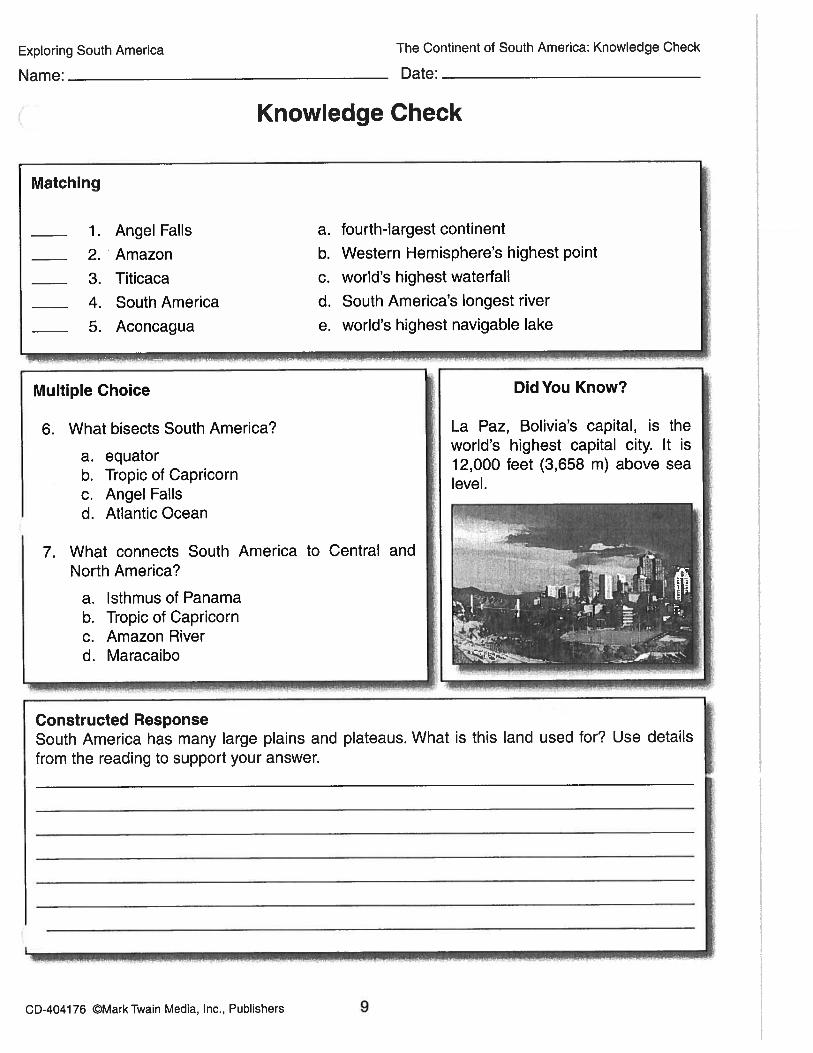
Exploring South America The Continent of South America: Knowledge Check
Name:
_______________
Date: —
Knowledge Check
Matching
1. Angel FaUs a. fourth-largest continent
2. Amazon b. Western Hemisphere’s highest point
3. Titicaca c. world’s highest waterfall
4. South America d. South America’s longest river
5. Aconcagua e. world’s highest navigable lake
Multiple Choice Did You Know?
6. What bisects South America? La Paz, Bolivia’s capital, is the
a equatorworld’s highest capital city. It is
b. Tropic of Capricorn12,000 feet (3,658 m) above sea
c. Angel Fallslevel.
d. Atlantic Ocean
7. What connects South America to Central andNorth America?
a. Isthmus of Panamab. Tropic of Capricornc. Amazon Riverd. Maracaibo
-—-—————.— -------.---.
Constructed ResponseSouth America has many large plains and plateaus. What is this land used for? Use details
from the reading to support your answer.
CD-404176 ©Mark Twain Media, Inc., Publishers 9
NAME DATE
___________
CLASS
_____
- netw*ksAndes and Midlatitude Countries j\
Lesson 1: Physical Geography of the Region
ESSENTIAL QUESTIONHow does geography influence the way people live?
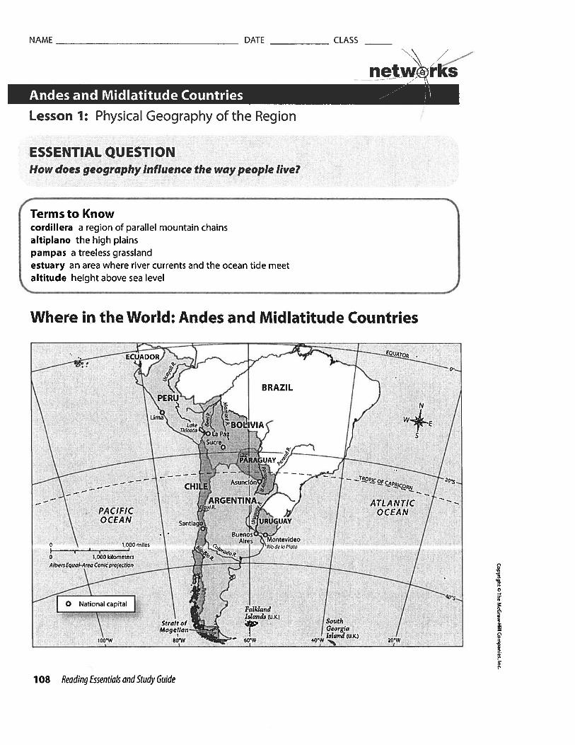
Where in the World: Andes and Midlatitude Countries
t
0
0
aI
n0a
Terms to Knowcordillera a region of parallel mountain chainsaltiplano the high plainspampas a treeless grasslandestuary an area where river currents and the ocean tide meetaltitude height above sea level
J2TOR.
BRAZIL / ) N
— — — — — CHILE
— - —ARGENTINA. / ATLANTIC —
PACIFIC , OCEANOCEAN Santia URUGUAY
BuenosAires Montevideo
0 1 000 miles R . I °Iot
1,000 kilometersAlbeo Equal-Area Conic projection
40,s..0 National capital
FalkiandIslands (U.K.l
Strait of SouthMoge1Ian—.-._ I Georgia
Island (U.K.)100W 80W — 60 W 40 W 20W
108 Reading Essentials and Study Guide
NAME DATE CLASS
__________
Andes CountriesGuiding Question What are the physical features of the Andeanregion?
Three countries make up most of the region of the Andesmountains: Peru, Bolivia, and Chile. The Andes are the longestcontinuous group of mountain ranges in the world. They stretch for4,500 miles (7,242 km). They are also the tallest mountains in theWestern Hemisphere. They consist of parallel ranges calledcordilleras. In Peru and Bolivia, the two main branches of theAndes lie alongside the altiplano, or high plain.
These mountain ranges are the result of collisions betweentectonic plates. The Andes are part of the Ring of Fire. Because ofthis, there are earthquakes and volcanic eruptions throughoutmuch of the Andes. The Andes lie 100 to 150 miles (161 to 241 km)inland from the coast. In most places, the land rises steeply fromthe ocean, with almost no coastal plain.
On the Atlantic side of South America, there are broad plateausand valleys. This plain is called the pampas. It is treeless grasslandwith fertile soil eroded from the Andes. This area is good forgrowing wheat and corn and for grazing cattle.
Coastal Peru and Chile and most of southern Argentina aredesert. Wind patterns, the cold Peru Current, and high elevationscause low precipitation. There are places in the Atacama Desert inPeru and northern Chile where no rainfall has ever been recorded.The Patagonia desert in Argentina lies in the rain shadow of theAndes.
The Paraná, the Paraguay, and the Uruguay rivers combine toform the second-largest river system in South America. Only theAmazon system is larger. The Paraná-Paraguay-Uruguay system isespecially important to Paraguay, which is landlocked. It providestransportation and makes hydroelectric power possible. Along theParaguay River is the Pantanal, one of the world’s largest wetlands.It has a diverse ecosystem of plants and animals.
This river system flows into the Rio de Ia Plata, which emptiesinto the Atlantic Ocean on the border of Argentina and Uruguay.There is a broad estuary where the river meets the Atlantic. This isan area where the ocean tide meets a river current.
There are few large lakes in South America. The largest lake inthe Andean region is Lake Titicaca, on the altiplano betweenBolivia and Peru. It is the highest lake in the world that is large anddeep enough to be used by small ships.
‘ /
netwrKs
Lesson 1: Physical Geography of the Region, continued
DrawingConclusions
1. On which side of theAndes do you thinkagriculture would bemost productive?Why?
Marking theText
2. Read the text on theleft. Highlight thenames of major riversof the region.
Defining
3. What is the definitionof estuary?
ReadingProgressCheck
4. How do you think thegeography of theAndean region affectsthe lives of the peoplewho live there?
Reading Essentials and Study Guide 109
ELi
3
2
a

NAME DATE
___________
CLASS
_____
Comparing
Defining
6. Why is altitude animportant feature inthe Andean region?
Marking theText
7. Read the text on theright. Highlight thenamesoftwotypesof pextreme weatherpatterns that occur inparts of South America I
ReadingProgress Check
8. Why is the tierratemplada the mostpopulated climatezone by altitude in theAndean region?
110 Reading Essentials and Study Guide
Lesson 1: Physical Geography of the Region, continued
/
netw©rks
How does the climateof the Andes countriescompare with that ofthe midlatitudecou ntries?
Climate DiversityGuiding Question How does climate affect life in the Andeanregion?
Climate in the Andes is chiefly determined by altitude, or heightabove sea level. The higher the altitude, the cooler thetemperatures. Farming is difficult in the Andean region. Farmersgrow crops on hillside terraces. The altitude also makes breathingdifficult because the oxygen is thin. The region’s inhabitants, aswell as native species of plants and animals, have adapted tothinner air.
The midlatitude countries of South America have temperate, ormoderate, climates. In Uruguay, rainfall is evenly distributedthroughout the year. The areas farthest from the seacoast tend tobe driest. Argentina is much larger than Uruguay. Its climate variesfrom subtropical in the north to tundra in the south. Paraguay isgenerally subtropical. Strong winds often sweep its pampas.
Climate extremes can be experienced in the Andean countrieswithout changing latitude. All that has to change is altitude. Theclimate changes greatly from lower to higher elevations.
rti4 ri r- ii-
tierra caliente (“hot land”), bananas, sugarcane, cacao,near sea level rice, other tropical plants
tierra templada (“temperate land”), corn, coffee, cotton, wheat,3,000—6,000 ft. (914—1,829 m) citrus fruits
tierra frIa (“cold land”), forests, grassy areas,6,000—10,000 ft. (1,829—3,048 m) potatoes, barley, wheat
Above the tierra frIa is the tierra helada, or “frozen land.” Verylittle vegetation grows in this climate and few people live there.
Every few years, extreme weather occurs in parts of SouthAmerica. This is caused by changes in wind patterns and oceancurrents in the Pacific Ocean. One of these events is called El Niño.It occurs when cold winds from the east are weak, causing thecentral Pacific Ocean to grow warmer. Water evaporates, and moreclouds form. Some areas receive heavy rains. Floods occur in someplaces, especially along the coast of Peru. Other areas have below-normal rainfall.
In some places, the opposite kind of unusual weather takesplace. This event is called La Nina. Winds from the east becomestrong and cool more of the Pacific.
t
•0
NAME DATE CLASS
__________
\\ // —,—
netw,’rksAndes and Midlatitude Countries 1’Lesson 1: Physical Geography of the Region, continued
Natural ResourcesGuiding Question Which natural resources are important to theregion?
The Andean and midlatitude countries are rich in natural resources.Energy resources are especially important. Bolivia has the second-largest natural gas reserves in South America, as well as largepetroleum deposits. In Paraguay, hydroelectric power plantsproduce most of the country’s electricity. The governments want touse these resources to develop and strengthen their economies.
The Andes have one of the world’s most important miningindustries. Chile leads the world in copper exports. Tin productionis important to Bolivia’s economy. Both Bolivia and Peru havedeposits of silver, lead, and zinc. Peru has gold.
The region’s varied geography and climate support a variety ofwildlife, including many species of birds and butterflies. The abilityof plants and animals to thrive in the region varies with altitude.
A group of mammals called camelids is especially important inthis region. Camelids are relatives of camels, but they do not havethe typical humps of camels. Two kinds of camelids are the llamaand the alpaca. Llamas are the larger of the two. They serve as packanimals and as a source of food, wool, and hides. Llamas live inherds and are tended primarily by the Native Americans of Bolivia,Peru, Ecuador, Argentina, and Chile.
Alpacas are found only in central and southern Peru and westernBolivia. Alpacas are the most important camelids for fleeceproduction. In the Inca culture, only royalty and nobles could wearrobes made with alpaca fleece.
, Marking theText
9. Read the text on theleft. Highlight thenatural resourcesfound in Bolivia.
Explaining
10. Why is there such awide variety of wildlifein the Andean andmidlatitude countriesof South America?
aE
a
WritingCheck for Understanding
1. Informative/Explanatory Why do earthquakes and volcanoes occur in the Andes?
ReadingProgress Check
11. What metal is importantto Chile’s economy?
2. Informative/Explanatory What effect does altitude have on the climates of the Andeancountries of South America?
Reading Essentials and Study Guide 111

NAME
_________________________________________
DATE
_______________
CLASS
__________
\/_,__
Geography and Economics Activity netwrksSouth America
Brazilian Land Use and Environmental Impacts
The economy of Brazil ranks among the highest among all the countries ofSouth America, and its position in the global market is strong. Brazil is hometo many valuable natural resources. It has large and growing agricultural,mining, service, and manufacturing sectors. Its agricultural products includecoffee, soybeans, wheat, rice, corn, sugarcane, cocoa, citrus, and beef. Itsmany manufacturing facilities produce textiles, shoes, chemicals, cement,lumber, iron, steel, and machinery and equipment.
Making use of the resources from the natural environment is a good way tosupport the economy by creating jobs and products. However, taking careof the environment is important so that resources are available when theyare needed in the future. This task is not always easy. Decisions must bemade to encourage people to use natural resources in a way that is alsogood for the environment.
Brazil’s Amazon Rain Forest
Brazil contains about one-third of the rain forests in the world, including theAmazon rain forest. The Amazon rain forest is one of Brazils’ most importantfeatures. Many of the country’s resources come from the rain forest.
Before the 1 960s, getting into the interior of the rain forest was difficult dueto tight government restrictions. As a result, the rain forest remained mostlyuntouched and preserved. Then during the 1 960s, farmers began toestablish farms in the Amazon rain forest. They did so by cutting andburning rain forest trees and other plants to clear land. These practicesresulted in poor soil quality in a short amount of time. As a result, thefarmers would constantly move to new areas where they would cut andburn more rain forest. In a relatively short time, these farming practices ledto considerable deforestation. The Amazon rain forest began to disappear,and what remained was being broken into smaller, individual areas.
Trans-Amazonian Highway
Before the 1 960s, moving from one place in Brazil to another could bedifficult because it was difficult to pass through the Amazon rain forest.However, in the 1 970s, work began on the Trans-Amazonian Highway. Thehighway was designed to be more than 2,000 miles (3219 kilometers) long.Its purpose was to connect different locations in Brazil as well as toneighboring countries. The hope was that the road would help the economyby making trade and the sale of goods within the country easier and byencouraging people to travel and live in new places.
1

NAME
_____________________________________________
DATE
_________________
CLASS
___________
\ /-. . . \\ /__
Geography and Economics Activity cont. netrksSouth America
Unfortunately, the road had some negative impacts on the country. Buildingthe road added to the deforestation that had begun with the cut-and-burnactivities of farmers. The road flooded during the wet seasons, thus makingsome parts of it impossible to use. Important nutrients from the soil werewashed away during the rainy season. The soil itself was also washed awaybecause the trees were no longer there to hold it in place.
Due to these problems, some sections of the road were never finished.However, the part of the road that was built does connect areas of the forestthat people were not able to reach before the road was there.
Thinking Economically
Directions: Use the text to answer the following questions.
1. Explaining What was the original purpose of the Trans-Amazonian Highway?
2. Explaining What were one positive and one negative effect that the highwayhad on the environment?
3. Predicting Consequences What do you think might happen to the economyof Brazil if the deforestation of the Amazon rain forest is not slowed orstopped? Explain your reasoning.
0
‘0
C
0
_______________________________________________
r0
0
2
NAME
_________________________________________
DATE
_______________
CLASS
__________
. /Cultural Geography Activity netw@rksSouth America
Celebrating Carnival
Easter is a Christian holiday celebrating Christ’s resurrection (coming to lifefrom the dead). For Christians the six-week period leading up to Easter, calledLent, is a solemn time. The days leading up to Lent, however, can be a time ofgreat celebration. During this time people in many countries celebrate a four-day holiday called Carnival. These celebrations are big and bold in Brazil.
The modern version of Carnival in Rio de Janeiro started in the mid-i 800swith organized parades for family and friends. Some of the early paradeswere by invitation only, but, before long, even the emperor joined in the fun.Carnival has grown even larger since then.
Today, samba schools play a huge role in Rio’s Carnival. These schools teachsamba, a type of dance. Music in these schools had its roots in Afro-Brazilianculture, but later samba dances blended the polka, tango, and waltz.Carnival parades in the city include groups of dancers from different sambaschools. The dancers use their costumes, music, and moves to tell storiesalong more than 100 different block parades.
Other regions of Brazil have their own distinctive Carnival festivities.Salvador was home to many African slaves, and its culture has a strongAfrican heritage that is reflected in Carnival. Dancers perform to samba andreggae music blasted from huge speakers on trucks. One of the biggestCarnival parades in the world is Gab da Madrugada in Recife. Carnival thereincludes the Night of the Silent Drums, a touching remembrance to theregion’s African slaves. Other Brazilian locations, such as Olinda, have strongIndian musical influences. In each celebration, the costumes and themakeup are carefully chosen to tell a story or depict a theme.
Directions: Use the passage to answer the questions below.
1. Explaining Why does Carnival take place?
0•0
2. Making Generalizations Brazil is often described as multicultural. What doesmulticultural mean? What examples in the text support this description?


Exploring Europe The Continent of Europe: Close-Up
The Continent of Europe: Close-Up
Europe is part of the huge landmass of Eurasia. Most geographersagree that the border between Europeand Asia is the Ural Mountains, the UralRiver, the Caspian Sea and the Caucasus Mountains.
Europe is the second-smallestcontinent. Only Australia is smaller.However, it is the third-largest continentin population. Northern Europe is in theArctic Circle and southern Europe borders on the Mediterranean Sea. Thewestern coast of the continent is on theAtlantic Ocean, and the eastern borderis the Ural Mountains in Russia. Thewestern part of Russia is included aspart of Europe, while the eastern area is part of Asia.
IslandsTechnically, Great Britain is not part of the continent. It consists of several islands. However,
3nd the islands of Crete, Iceland, Sardinia, and Sicily are usually considered to be part of Europe.
PeninsulasEurope contains several peninsulas. Spain and Portugal form the Iberian Peninsula. Italy
is a peninsula.The Scandinavian Peninsula includes Finland, Norway, and Sweden.The JutlandPeninsula includes Denmark.
MountainsThree of Europe’s mountain ranges, the Carpathians, the Caucasus, and the Urals, are in
Russia. The major European mountain range is the Alps, located in Switzerland, France, Austria,Germany, Italy, and Slovenia. The Pyrenees form the border between France and Spain, and theDolomites are in Italy.
Europe’s highest point is Mount Elbrus (18,510 ft. or 5,642 m) in the Caucasus Mountainsof Russia. One of the most famous mountains in Europe is Mount Blanc (1 5,771 ft. or 4,807 m)on the border between France and Italy.
Oceans and SeasIn addition to its coasts on the Atlantic Ocean, Caspian Sea, and the Mediterranean Sea,
Europe has borders on the Arctic Ocean, Baltic Sea, Black Sea, and the North Sea. Its lowestpoint is at the Caspian Sea (92 ft. or 28 m below sea level).
Rivers and LakesThe Volga, in Russia, is Europe’s longest river. The Danube is Europe’s second-longest
river. Other major rivers include the Rhone, Seine, and Loire in France; the Po in Italy; and thee and Rhine in Germany. Britain’s most important river is the Thames. Europe has many lakes,
especially in the mountain regions. Its largest freshwater lake is Lake Ladoga in Russia.
U.•UU —-
c . ..
I.
-
:.--
... .;\- :—
-• - ..
- .... :.... ... . -
CD-4041 74 ©Mark Twain Media, Inc., Publishers 7

Exploring Europe The Continent of Europe: Knowledge Check
Name:
_______________
Date:
Knowledge Check
Multiple Choice
6. This is Europe’s second-longest river.
a. Volgab. Rhinec. Danubed. Po
Did You Know?
Matching
1. Iberian Peninsula a. country located in Europe and Asia2. Russia b. Europe’s largest freshwater lake3. Mount Blanc c. Europe’s longest river4. Volga d. location of Spain and Portugal5. Lake Ladoga e. one of Europe’s most famous mountains
——----————————-
7. This is Britain’s most important river.
a. Thamesb. Elbec. Loired. Seine
A lake is a body of water surrounded by land. Technically, the Gaspian Sea, on the border betweenEurope andAsia, is alake and nota sea. It isthe world’slargest lake.
Constructed ResponseExplain how Russia can be considered part of Europe and Asia. Use details from the selectionto support your answer.
CD-404174 ©Mark Twain Media, Inc., Publishers 9

NAME DATE
___________
CLASS
_____
(
‘N
netw®rks
Western Europe I”Lesson 1: Physical Geography of Western Europe
Where in the World: Western Europe
t
8-4
I
n0
ESSENTIAL QUESTIONHow does geography influence the way people live?
Terms to Knowdike a large barrier built to keep out waterpolder the land reclaimed from building dikes and then draining the water from the land
estuary an area where river currents and the ocean tide meet
Westerlies strong winds that blow from west to east
deciduous trees that shed their leaves in the autumnconiferous evergreen trees that produce cones to hold seeds and that have needles instead
of leaves
120 Reading Essentials and Study Guide

NAME DATE
___________
CLASS
Western Europe includes the nations of Ireland, the UnitedKingdom, France, Germany, the Netherlands, Belgium,Luxembourg, Austria, and Switzerland. It also includes the tinycountries of Monaco and Liechtenstein.
The landscape of the region consists of plains with mountains insome places. Much of Western Europe lies in the NorthernEuropean Plain. Massive sheets of ice shaped the plain during thelast ice age, which ended about 11,000 years ago. Melting glaciersleft behind fertile soil, but also thick layers of sand and gravel.These deposits have eroded into sand dunes along some of theNorth Sea coastline. The glaciers also left behind areas of poorlydrained wetlands along the coasts of the British Isles.
Two mountain ranges separate Western Europe from SouthernEurope. They divide the cooler climates of the north from thewarm, dry climate of the Mediterranean region to the south.
Range Pyrenees Alps
Location Between France France, Switzerland,and Spain Austria, Germany
Length 270 mi (435 km) 750 mi (1,207 km)
Tallest Pico de Aneto Mont BlancPeak 11,169 ft (3,404 m) 15,771 ft (4,807 m)
The Pyrenees and the Alps were created by the folding of rocksas a result of plate tectonics. They were also shaped by glaciers.These mountains are younger than other mountains in Europe.
Western Europe has long, irregular coastlines on the AtlanticOcean and the North, Baltic, and Mediterranean seas, The NorthSea is a part of the Atlantic Ocean that separates the island ofBritain from the rest of Europe. It is a rich fishing ground for theNetherlands and the United Kingdom. It has long been importantfor trade. It is also the location of large oil and gas reserves.
The North Sea has helped and hindered the Dutch, the peopleof the Netherlands. Because 25 percent of the Netherlands isbelow sea level, the Dutch have built dikes, walls to hold back thewater. They call the land they reclaim from the sea polders. Thisland is used for farming and settlement. Stormy seas have brokendikes and caused flooding in recent times.
Lesson 1: Physical Geography of Western Europe, continued
\\
Landforms and WaterwaysGuiding Question How do the physical features of Western Europemake the region unique?
Marking theText
1. Read the text on theleft. Highlight thenames of the nationsthat make up WesternEurope.
U Describing
2. How have glaciersshaped the landscapeof Western Europe?
Comparing
3. Compare WesternEurope’s two majormountain ranges.
Listing
4. Which bodies of waterlie off the coast ofWestern Europe?
E0L)
I
V
0.
Reading Essentials and Study Guide 121

NAME DATE
____________
CLASS
_____
The British Isles are off the northern coast of France. The EnglishChannel separates southern Britain from northern France. It is abusy sea route connecting the North Sea with the Atlantic Ocean.High-speed trains run through the Chunnel, a tunnel under theEnglish Channel, connecting Britain to mainland Europe.
Western Europe has many rivers and small waterways. Riversdetermined the location of important cities, such as London, Paris,and Hamburg. Rivers and canals provide transportation routes forgoods and people. Rivers provide water for farming and produceelectrical power. They also form political borders. The Thames Riverin England becomes an estuary when it reaches London, thenextends to the North Sea. An estuary is where river currents andocean tides meet. The Rhine is the busiest waterway in Europe. Itruns through the most populated region in Europe, from the SwissAlps to the North Sea.
ClimateGuiding Question Why is the climate mild in Western Europe?
Western Europe is located at northern latitudes, but has a milderclimate than other places at the same latitudes. This is becausemost of Western Europe lies in the path of the Westerlies. Theseare strong winds that travel from west to east. They are heated bythe warm water of the North Atlantic Current, which originates inthe tropical waters of the Caribbean Sea.
This warm, moist air moves inland on the Westerlies. It bringsmild temperatures and rain to most of Western Europe throughoutthe year. Summers are cool, and winters are mild. This climate isknown as a marine west coast climate. Because there are nocoastal mountain ranges to stop it, the Westerlies blow across theEuropean continent.
Other areas of the region, such as southern France, have a drierclimate. Summers are hot and dry, and winters are mild or cool.Most of the rainfall occurs in spring and autumn. This is called aMediterranean climate.
Natural ResourcesGuiding Question How do the people of Western Europe use theregion’s natural resources?Deposits of coal are plentiful throughout much of Western Europe.Coal fueled machines invented during the Industrial Revolution ofthe 1800s. Today, coal is less important than other energy sources.
Lesson 1: Physical Geography of Western Europe, continued
netwrks
> Marking theText
5. Read the text on theright. Underline thesentence that tells howBritain is connected tomainland Europe
ReadingProgress Check
6. How did the rivers inWestern Europe affectits economicdevelopment?
I!
IL_122 Reading Essentials and Study Guide
> Marking theText
7. Read the text on theright. Highlight thedescription of theMediterranean climate.
ReadingProgress Check
8. How do the Westerliesaffect the climate inWestern Europe?
-4
3t

NAME DATE
___________
CLASS
_____
netw:rks
Western Europe -- :\
Lesson 1: Physical Geography of Western Europe, continued
In 1959 oil and natural gas were discovered under the North Sea.
The United Kingdom, the Netherlands, and Germany produce oil
and natural gas from the North Sea. Other countries use their
rivers to supply energy. Hydroelectricity supplies more than half of
Switzerland’s electricity needs.
The Northern European Plain has some of the richest soils in
Europe. France is Western Europe’s leading agricultural producer.
Northern France produces wheat. Orchards and vineyards are
common in the central and southern parts of the country. Dairy
farming is important for the economy of the Netherlands.
The moderate climate and abundant rainfall in most of Western
Europe support a variety of plant and animal life. The British Isles
have dense forests, grasslands, scrublands, and wetlands. The
natural vegetation is mostly deciduous forest, or trees that lose
their leaves in the fall. The climate on the mainland of Europe is
more diverse than that of the British Isles and supports a wider
range of plant life.
The drier climates farther inland, as well as the highlands and
mountain ranges, support other kinds of plants. Coniferous trees,
such as fir and pine trees, have cones and needle-shaped leaves.
They keep their foliage during the winter. Above the tree line,
grasses and shrubs are the most common plants.
Deer, wild boars, hare, and mice are common. Wildcats, lynx, and
foxes roam the forests. There are brown bears in the Pyrenees. The
number of large animals has decreased in the British Isles, but the
islands have more than 200 kinds of birds.
Marking theText
9. Read the text on theleft. Highlight energysources that areimportant in WesternEurope today.
Defining
10. How do deciduous andconiferous trees differfrom each other?
ReadingProgress Check
11. What effect did coalhave on the IndustrialRevolution?
0.E0U
0
I—0
‘-2
WritingCheck for Understanding
1. Informative/Explanatory Why is the North Sea important to Western Europe?
2. Informative/Explanatory Describe the agriculture of Western Europe.
Reading Essentials and Study Guide 123

Geography and Economics Activity
The Banking Crisis in the European UnionWhen the European Union (EU) wasformed in 1993, the hope was that astrong bond would form among thenations in the Union to bring economicstability and peace. The new Unionwould make trade easier and moresuccessful. Each nation would continueto have its own government and couldstill make its own economic decisionsunder this new Union, yet they wouldbe united in some important ways. Twosuch ways are using the same currency,the euro, and sharing one bankingsystem. In many ways, the plan was asuccess. The European Union startedwith 12 member nations, and it morethan doubled within 20 years.
The Crisis
Nations of the European Union
0V
to
-4
ID
SI
I,0SV
DED
NAME DATE
Europe i\
CLASS
__________
\\ /__““-
netw©rks
t4
I :‘%_
f NORWA91 i 0rgnI re,r,bero, 993
ATLANTIC /‘•,‘ \LIiM’eoE;c ngn199
OCEAN
ODNMADX
‘ Jo gn2007
N th ‘7 M be; 92013
IRELAND liNflED S a
KINGDOM
•atA4RR‘0” BELAFIUS 4
GERMANY PM
f%_____,_/ SW AL
PORTU0LISPAIN
/
91ak Se
LfAlA
f 0 0,). Mediterranean Sea lot IDE
Just as all of the member nations could benefit from the Union, they couldalso all suffer if economies failed. And that is just what happened in 2008,when the global economy entered a difficult recession period. Many banksaround the world entered a crisis stage, including the banks of the EuropeanUnion. About 6,000 banks were transacting in the euro. Many of theseindividual banks did not have enough money to lend to people. They couldno longer carry out day-to-day services. With a Union of 27 nations tied tothe banking system, the problems became widespread. The weaknesses inthe Union could be seen. The EU had no framework in place that describedwhat to do in the event of a banking crisis.
Countries React
Individual countries in the European Union acted under their own nationallaws to quickly stabilize banks and to prevent the crisis from spreadingthroughout the entire banking industry. The individual countries putsystems into place that would help families, individuals, and companies.
1
NAME
___________________________________________
DATE
________________
CLASS
__________
. . /
Geography and Economics Activity cont. net.w:rksEurope
in 2012, in response to the crisis, the EU put plans in place to help all the
countries of the Union avoid a future banking crisis and to help themrecover in the event of future banking problems. It was important that plans
for the European Union would still allow individual countries to handle their
own economies as they wished.
The European Union Today
Today the EU provides greater supervision of its member nations. It has set
up three groups to make sure that EU rules are applied consistently among
the member nations and to help coordinate the work of bank regulators in
these member nations. The EU has the power to take corrective action
against any bank that does not adhere to the guidelines. Part of the plan is
to make sure that individual banks have enough assets to continueoperating if they experience monetary losses. The EU also has an initiative to
close banks that are not capable of continuing under the EU rules and toprovide bank depositors with a guarantee for the money they put in thebank. Laws and regulations of the European Union will continue to changeand improve so that they are ready to deal with future problems that mayoccur.
Thinking Economically
Directions: Use the text to answer the following questions.
1. Summarizing Why was the European Union founded?
2. Determining Central Ideas How did a global financial problem in 2008 affect
the European Union?
0
_________________________________________________________________________________
0
3. Inferring Why is the EU’s ability to solve financial problems important to its
member nations?
2

Exploring Africa The Continent of Africa: Close-Up
The Continent of Africa:Close-Up
Africa is the second-largest continent;only Asia is larger. Africa’s land mass coversover 11,677,000 square miles (30,243,000sq. km) and includes several islands. Thelargest island is Madagascar, located off thesoutheast coast. Africa contains 23 percentof the world’s total land area and is threetimes as large as the United States.
The equator divides Africa in half.Africa’s northernmost point is 35° North, andits southernmost point is 36° South. Africa isalmost completely surrounded by water. Thenorthern coast is on the Mediterranean Sea.The western coast is on the Atlantic Ocean,and the eastern coast is bordered by the RedSea, the Arabian Sea, and the Indian Ocean.A small land border joins Egypt and Israel.
The Land• The continent is mainly plateau land. It does have narrow coastal plains and a few mountain
ranges. The highest point in Africa is Mount Kilimanjaro. It is 19,341 feet (5,895 m) abovesea level. The lowest point is Lake Assai, which is 502 feet (153 m) below sea level.
• The Sahara is the world’s largest desert. It covers over 3,500,000 square miles (9,065,000sq. km). The Sahara covers one-fourth of the continent. It cuts through the northern part ofAfrica, dividing the continent into northern and southern regions. The northern regions aremuch more highly developed.
• Southern Africa also has desert terrain. The Namib Desert and the Kalahari Desert arelocated in Namibia and Botswana.
Rivers• The major rivers of Africa are the Nile and the Congo (also called the Zaire). The Nile is
the world’s longest river. It has a length of 4.160 miles (6.695 km).The Congo River. 2,718miles long (4,374 km), drains much of central Africa. The Niger River, 2,600 miles long(4,184 km), empties into part of the Atlantic Ocean known as the Gulf of Guinea.
Lakes• Lake Victoria is Africa’s largest lake. It is the third-largest lake in the world. Lake Victoria
covers over 26,800 square miles (69,400 sq. km). One branch of the Nile River begins atLake Victoria.
Waterfalls• Africa contains one of the world’s most spectacular waterfalls. They were named the \‘
na Falls by the Scottish explorer David Livingstone in honor of Queen Victoria of England.Victoria Falls are on the Zambezi River in Zimbabwe near the border with Zambia.
CD-404170 ©Mark Twain Media, Inc., Publishers 8

Exploring Africa The Continent of Africa: Knowledge Check
Name:
_______________
Date:
Knowledge Check
Matching
1. Nile a. world’s largest desert
2. equator b. Africa’s largest lake
3. Sahara c. highest point in Africa
4. Mount Kilimanjaro d. divides Africa in half
5. Lake Victoria e. world’s longest river
Multiple Choice Did You Know?
6. What fraction of Africa is covered with desert? The Sahara is the world’s largest
a one-half and hottest desert. It stretches
b one-fourth 3,000 miles (4,828 km) from the
c: three-fourths Atlantic Ocean to the Red Sea. It
d two-thirds is larger than the entire continentof Australia!
7. How long is the Nile River?
a. 2,460 milesb. 2,718 milesc. 4,160 milesd. 5,800 miles
Constructed ResponseIn your opinion, what impact does the Sahara desert have on the continent of Africa? Use atleast two details from the selection to support your answer.
CD-404170 ©MarkTwain Media, Inc., Publishers 10

NAME DATE
___________
CLASS
_____
\ / -
netwrksNorth Africa -- )Lesson 1: Physical Geography of North Africa
ESSENTIAL QUESTIONHow does geography influence the way people live?
Where in the World: North Africa
•0
-4
n0
Terms to Knowdelta area formed by soil deposits at the mouth of a riversilt fine, rich soil good for farmingwadi dry desert riverbederg vast stretches of sandnomad person who lives by moving from place to place to in search of foodphosphate chemical compound used to make fertilizeraquifer underground layer of rock in which water collects
220 Reading Essentials and Study Guide

NAME DATE CLASS
//__.--
netw:rksNorth Africa .—
)‘
Lesson 1: Physical Geography of North Africa, continued
;> Marking theText
1.
Landforms and WaterwaysGuiding Question How have physical features shaped life inthe region?
North Africa includes five countries. Egypt is the easternmostcountry in the region. Some of Egypt is in Southwest Asia. Libya isto Egypt’s west. Tunisia and Algeria are west of Libya, and Moroccois farthest to the west.
Highlight all the areasin North Africa thathave mountains.
Identifying
2. What bodies of waterborder North Africa?
Describing
3. Describe the course ofthe Nile through NorthAfrica.Low, narrow plains sit on the edges of the region’s Atlantic and
Mediterranean coasts. In the west, the Atlas Mountains rise behindthese coastal plains. The mountains extend across Morocco andAlgeria into Tunisia. South of the Atlas Mountains is a low plateauthat stretches across most of North Africa.
In Egypt, the southern part of the Nile River cuts through ahighland area. There it forms a deep gorge, or valley. SoutheasternEgypt has low mountains on the shores of the Red Sea. The southernpart of Egypt’s Sinai Peninsula is also mountainous. NorthwesternEgypt has a large area of lowland that contains marshes and lakes.
After the Mediterranean Sea, the most important body of waterin the region is the Nile River. At 4,160 miles (6,695 km), it is thelongest river in the world, It begins far south of Egypt at LakeVictoria in East Africa. Then it flows northward and is joined byseveral tributaries, including the Blue Nile.
The Nile has a large delta at its mouth on the MediterraneanSea. A delta is an area formed by soil deposits that build up as ariver’s waters slow down. Deltas often form where a river entersa larger body of water.
The Nile brings life to dry Egypt. In ancient times, it flooded eachyear. These floods left silt along the banks of the river and in thedelta. Silt is a fine, rich soil that is excellent for farming. Becausefarmers could grow food there, they were able to support a greatcivilization. Ancient Egypt was called “the gift of the Nile.”
Defining
4. What is a delta?
0.
I
.0
0.0
Explaining
5. How do farmersbenefit from floodsalong the Nile River?
Reading Essentials and Study Guide 221

NAME DATE
___________
CLASS
/
netw*ksNorth Africa j\
Lesson 1: Physical Geography of North Africa, continued
Explaining
6 Why is the Suez Canalimportant7
________________
ReadingProgress Check
7. Why was ancient Egyptcalled “the gift of theNile”?
Marking theText
8. Underline the textthat explains the rainshadow effect.
Defining
9 What is a wadi7
ReadingProgress Check
10 Where do you thinkmost people in NorthAfrica live7 Why?
222 Reading Essentials and Study Guide
Today, several dams control floods on the Nile. They hold backthe high volume of water during rainy season. Then they releasewater during the rest of the year. There are advantages anddisadvantages to the dams.
• Crops can be grownall-year long
• Security from floods
I. Silt no longer settlesand enriches the soil
Egypt controls the Suez Canal. This human-made canal connectsthe Mediterranean Sea to the Red Sea. It links Europe and NorthAfrica to the Indian and Pacific Oceans. International trade dependson ships travelling through the canal instead of all the way aroundAfrica. The canal saves many days of travel time and fuel.
ClimateGuiding Question How do people survive in a dry climate?Inland North Africa is dry. One reason is the rain shadow effect.This is when moist air blows south and rises up the AtlasMountains, cooling the air and releasing rain. By the time the airpasses over the mountains, it is dry. Also high-pressure air systemsfall over areas to the south, sending hot, dry air north. When itdoes rain in the desert, southern winds soon follow. These windsdry the land and leave behind wadis, or dry streambeds.
Much of North Africa is covered by the Sahara. The Sahara’svast stretches of sand are called ergs. Strong winds blow thesand, creating dust storms and sand dunes. Ergs cover only abouta quarter of the Sahara. There are also rocky plateaus callshamadas, rocks eroded by wind, and oases.
Trade caravans and nomads rely on oases. Nomads are peoplewho move about from place to place in search of food. They useplants in oases to graze herds of sheep or other animals. Somepeople live on oases and grow crops.
In the north, a band of steppe area encircles the desert fromcoast to coast. In the steppe, temperatures are high and rainfallis slightly greater than in the desert.
A Mediterranean climate dominates the western coast. Thisgives the region warm, dry summers and mild, rainy winters. Morerain falls along the coast and on the mountain slopes. Highlandclimates are found in the mountains. Morocco’s Atlas Mountainscan even get snow in the winter.
nat
I
C,
3•0

NAME
_________________________________
DATE
___________
CLASS
_____
N\ /netw@rks
North Africa
Lesson 1: Physical Geography of North Africa, continued
ResourcesGuiding Question What resources does North Africa have? Marking the
Libya is the most oil-rich country in North Africa. It has the ninth- Text
largest amount of oil reserves in the world. It also has smaller 11. Circle the word thatamounts of natural gas. Algeria has large reserves of both natural gas describes a chemicaland oil. Like Algeria, Egypt has larger reserves of natural gas than oil. used in fertilizer.
Tunisia’s main resources are iron ore and phosphates. Phosphates
are chemical compounds often used in fertilizers. Morocco also has Explainingphosphates, as well as rich fishing grounds off its coast. 12. How do people access
All five North African countries struggle to get enough water. the water in aquifers?Limited rainfall and high temperatures leave little fresh water on the
surface. Rains can be heavy when they come, but the sandy soil soon
absorbs the water. Dry winds evaporate the rest. Only the Nile is a
____________________
reliable source of water for farming. Ninety-five percent of Egyptians
live within 12 miles of the Nile or its delta. They could not survive Readingwithout its water. Progress Check
Outside the Nile valley, most of the water comes from oases and. 13. Why would aquifers
aquifers. Aquifers are underground layers of rock in which water take a long time to fillcollects. People use wells to tap into this water. Libya, for instance, up in North Africa?relies on aquifers for almost all of its water needs.
Demand for the water in an aquifer shared by Algeria, Libya, and
Tunisia has significantly increased in recent years. In North Africa,
aquifers take a long time to fill up again. If people keep taking water
____________________
out at a high rate, the aquifers could empty. Then the water
problem will become much worse.
WritingCheck for Understanding
1. Informative/Explanatory Which countries in the region are not likely to need to import
energy resources? Why?
2. Informative/Explanatory What sources of water do North Africans rely on and how are
those sources threatened?
‘C
aCU
Reading Essentials and Study Guide 223

NAME
___________________________________________
DATE
________________
CLASS
__________
\
Cultural Geography Activity neitw€’rksAfrica
Directions: Read the passage below and answer the questions that follow.
The Festival of ReplasteringEach year during the wet season, heavy rains fall on the Great Mosque inDjenné, Mali. The rains would not be a problem for most large buildings.However, the Great Mosque there is made of mud bricks. The rains washaway layers of mud, slightly changing the shape of the monument with eachrainfall.
To counter this problem, the residents of Djenné—young and old, male andfemale—come together each year to restore the historic mosque. They holdan annual festival called the Crepissage de Ia Grande Mosquée, or the Festivalof Replastering. Young girls and their mothers carry buckets of water to pitsfull of mud plaster. Young boys stir the mixture. Men perch on woodenscaffolding and repair the damaged walls. Drums pound in the backgroundas the people work. There is time for play, too—a special meal is prepared byeach family to celebrate the festival.
Just as the rains change the shape of the monument, the annualreplastering also alters the Great Mosque. Its edges are softened. Themosque is a unique historic monument in that it changes slightly from yearto year.
In 1998, the mosque and surrounding area were designated as a UNESCOWorld Heritage Site. This honor has been a mixed blessing for local residents.More tourists now come to see the mosque. However, the UNESCOdesignation prohibits changes to structures in the historic zone. People wholive near the mosque cannot add electricity or other modern conveniencesto their homes.
0V
C.
-4
It
I
03V
1
NAME
_____________________________________________
DATE
_________________
CLASS
___________
‘‘.‘ /Cultural Geography Activity cont. netwr $
Africa
1. Locating Where is the Great Mosque?
2. Explaining Why does the Great Mosque change slightly each year?
3. Evaluating What is one benefit of the UNESCO World Heritage Sitedesignation? What is one disadvantage?
4. Making Decisions Do you think it is fair that people cannot do what theywant to their homes because of the heritage site status? Explain.
0V
Lb
0
C,
03V
2

NAME
___________________________________________
DATE
________________
CLASS
__________
Environmental Case Study
MalariaThe World Health Organization estimates that half of the world’s population,or more than 3 billion people, are at risk of getting malaria. The organizationalso estimates that as many as 274 million people contracted the disease in2010 and that as many as 900,000 people may have died from the disease.Most of these people live in poor countries. In fact, 90 percent of all deathsfrom malaria in 2010 occurred in Africa, mostly in children under the age offive. In fact, malaria ranks as the fourth leading cause of children’s deaths.Only preterm birth, diarrhea, and pneumonia cause more deaths in children.
Malaria is caused by a parasite that can be passed from one person toanother by the bite of a mosquito. The bite introduces a parasite into aperson’s bloodstream. Here the parasite multiplies and begins to infect redblood cells, causing their destruction. With a loss of red blood cells, aninfected person soon becomes tired. The loss of red blood cells also preventsenough oxygen from reaching cells. Without oxygen, cells begin to die.Symptoms of malaria include a high fever, chills, weakness, and muscle pain.
Fighting Malaria
Preventing malaria may seem to be easy—simply kill the mosquitoes beforethey have a chance to bite people. This strategy worked well whenpesticides were first used to kill the mosquitoes. The first pesticide used tokill mosquitoes was a chemical substance called DDT. Beginning in the late1940s, DDT was routinely sprayed to kill mosquitoes with great success.However, scientists discovered that toxic products from DDT wereaccumulating in living things and were also damaging the environment. Inaddition, resistance to DDT was becoming much more common amongmosquitoes. In other words, DDT no longer killed nearly as manymosquitoes.
In 1972, the United States government banned the use of DDT. However,DDT is still used indoors in Africa where malaria remains widespread. Tounderscore the threat still posed by malaria, the World Health Organizationin 2006 declared its support of the indoor use of DDT in Africa.
A Solution from ChinaOnce pesticides such as DDT could no longer be used to kill mosquitoes,scientists began searching for something else that would treat malaria. Thissearch proved successful. However, scientists were actually not responsiblefor starting the search that eventually led to a new drug for treating malaria.
03
1

NAME
___________________________________________
DATE
________________
CLASS
__________
‘\ /..Environmental Case Study cont netw©rksAfrica
In fact, it was Mao Zedong, the Chinese leader in the 1 960s, who began theeffort. At that time, North Vietnam was fighting a war against the UnitedStates. The North Vietnamese were being supported by the Chinese. With somany of its soldiers dying from malaria, the North Vietnamese sent anappeal to Mao for help. In turn, Mao instructed his scientists to find a drugthat would be effective in fighting malaria.
In 1967, Chinese scientists started traveling into the countryside. They askedvillage leaders about local remedies that they were using to treat fevers.Almost all these remedies came from plants. The scientists’ search eventuallyfocused on a plant called qinghao.This plant is actually a weed thatproduces yellow flowers. Chinese scientists discovered that an extract fromthis plant killed malaria parasites in mice. In the 1970s, scientists identifiedthe chemical nature of the plant extract. Today, this drug is known asartemisinin.
A Miracle DrugMany scientists consider artemisinin a miracle drug in the fight againstmalaria. In fact, artemisinin is the only drug that is effective in treatingmalaria. Its use has reduced deaths from malaria by 30 percent in Africa andby 50 percent in 53 countries outside of Africa. In recognition of artemisinin’svalue infighting malaria, the theme of the World Malaria Day held in April2012 was”Sustain Gains, Save Lives: Invest in Malaria!’
Unfortunately, evidence is mounting that the gains made against malariamay no longer be sustainable. In 2006, parasites that were resistant toartemisinin first appeared in Cambodia. At about the same time in Thailand,doctors found that patients took longer and longer to recover from malariaafter being treated with the drug. This is evidence that resistance toartemisinin is spreading.
Scientists recognize that resistance to any drug is inevitable, especially whenit is widely used. In the case of malaria, the only hope is to identify and killresistant parasites before they have had a chance to spread.
0•0
C
tD
C,
0
0
2

NAME
___________________________________________
DATE
________________
CLASS
__________
/--
Environmental Case Study cont. netwrksAfrica
• People living in 106 countries located almost entirely on the continents ofAfrica and Asia face the threat of malaria.
• Several types of mosquitoes can cause malaria. One type can kill a personwithin a few hours after symptoms first appear.
• The use of qinghao to treat fevers in China dates back to over 200 years ago.
• In the 1 960s, American scientists also searched for a drug to treat its soldiersfighting in Vietnam. Unfortunately, their search led to a drug that causednightmares and other dangerous side effects.
• About 1,500 cases of malaria are diagnosed in the United States each year.Most of these cases are among people who have traveled to or immigratedfrom areas of the world where malaria is common.
Directions: Read the information about malaria. Then answer the followingquestions.
1. Identifying What three conditions are responsible for more deaths in childrenthan malaria?
2. Describing How are the symptoms of malaria and the flu similar?
3. Explaining Why is it that one drug cannot completely eliminate a diseasesuch as malaria?
0
____________________________________________________________________________________________
V‘C
‘00
0‘C
4. Hypothesizing In Africa, most people sleep in beds covered with netting.Why do you think this is done?
_________________________
That’s a Fact’


Exploring Asia The Continent of Asia: Close-Up
The Continent of Asia: Close-Up
4....
Natural Features -.
• Asia contains a wide range of natural features. Plains make up most of the continent. The
Plateau of Tibet is over one thousand miles (1 600 km) from east to west. It is the highestplateau in the world, with much of it over 12,000 feet (3,650 m) above sea level. The Pla
teau of Tibet is often referred to as “the roof of the world.” Russia, India, China, and southwest Asia also contain large plains.
• Asia has many mountain ranges. The most famous are the Himalayas. They are the world’shighest mountain range. Mount Everest is one of the Himalayan Mountains. It is the world’shighest point, 29,035 feet (8,850 m) above sea level.
• Deserts are also a major feature of Asia. Large deserts are north of the Himalayas and on
the Arabian Peninsula. The Syrian Desert spreads through parts of Jordan and Iraq. TheGobi Desert includes much of Mongolia.
• Asia has many important rivers. China contains Asia’s two longest rivers. The Yangtze,also named the Chang, is the continent’s longest river, stretching almost 4,000 miles (6,400km). The Huang River is almost 3,400 miles (5,500 km) long. Other major rivers include theIndus and Ganges, which flow through Pakistan, India, and Bangladesh. The Tigris andEuphrates Rivers flow through Syria, Turkey, and Iraq. The region near the Tigris and Euphrates was the location of one of the world’s oldest civilizations, which flourished around3500 B.C. Another important river, the Jordan River, forms part of the border between Israeland Syria and Israel and Jordan. The Jordan River flows into the Dead Sea.
• The world’s lowest point is near the Dead Sea. It is 1,340 feet (408 m) below sea level. TheDead Sea is a saltwater lake. The Caspian Sea, covering 143,250 square miles (371,000sq. km) is the world’s largest lake. Lake Baykal (also spelled Baikal), with a depth of over5,300 feet (1,600 m), is the deepest lake in the world.
Asia is the world’s largest continent. It covers over 17,200,000 squaremiles (44,500,000 sq. km). This is aboutone-third of the world’s total land surface.It stretches over 5,300 miles (8,500 km)from east to west.
Most of the continent is surrounded by water. Asia’s boundaries are theArctic Ocean on the north, the BeringStrait and the Pacific Ocean on the east,the Indian Ocean on the south, and theRed and Mediterranean Seas on thesouthwest. The west is a land border.The Ural and Caucasus Mountains arethe dividing line between the continentsof Asia and Europe.
CD-404172 @Mark Twain Media, Inc., Publishers 7

Exploring AsiaThe Continent of Asia: Knowledge Check
Name:
_______________
Date:
Knowledge Check
Multiple Choice
6. What fraction of the world’s total landsurface is located in Asia?
a. 3/4b. 1/2c. 1/3d. 2/3
7. The world’s lowest point is located
a. near the Dead Sea.b. near the Huang River.c. near the Gobi Desert.d. near the Himalayas.
Did You Know?Mount Everest was named for Sir GeorgeEverest, an Englishman who first determinedthe mountain’s location and height. In 1953,Sir Edmund Hillary of New Zealand and Tenzing Morkay of Nepal were the first to climb toits summit.
Matching
____
1. Caspian Sea a. world’s highest point
____
2. Lake Baykal b. Asia’s longest river
____
3. Plateau of Tibet c. world’s deepest lake
____
4. Mount Everest d. referred to as “the roof of the world”
____
5. Yangtze e. world’s largest lake
1
Constructed ResponseAsia has a wide range of natural features. Describe some of these features using details fromthe selection to support your answer.
CD-404172 ©Mark Twain Media, Inc., Publishers 9

NAME DATE CLASS
:
East Asia
Lesson 1: Physica’ Geography of East Asia
ESSENTIAL QUESTIONHow does geography influence the way people live?
Terms to Knowdefacto actually; in realityarchipelago a group of islandstsunami a giant ocean wave caused by an earthquake under the ocean floor
bess a fine-grained, fertile soil deposited by the wind
Where in the World: East Asia
aCt
a
3I
a03
I
158 Reading Essentials and Study Guide

NAME DATE
____________
CLASS
_____
/
netwyrksEast Asia
Lesson 1: Physical Geography of East Asia, continued
Landforms and WaterwaysGuiding Question What are the main physical features andphysical processes in East Asia?
East Asia is made up of six countries: China, Japan, Mongolia, North
Korea, South Korea, and the de facto country of Taiwan. A de factocountry is one that is not legally recognized. The region’s largest
country, China, is the world’s fourth-largest country in land area.
Mainland East Asia, which includes China and Mongolia, can bedivided into three subregions like steps. The highest step is thePlateau of Tibet. Much of it is more than 2.5 miles (4 km) above sealevel. High mountains circle the plateau of Tibet. The Kunlun Shanrange is on the north. On the south are the Himalaya, the tallestmountains in the world.
The middle step is north and east of Tibet and has lowermountains and plateaus. Much of the land to the north is desert ornear desert. Land along the southern part is forested. There aredeep canyons where the land descends from Tibet.
Low hills and plains form the third and lowest step, which coversmost of the eastern third of China. Most Chinese people live onthese plains. 1 Explaining
In addition to the mainland, East Asia includes a large peninsulabetween the Yellow Sea and the Sea of Japan (East Sea). It is hometo two countries, North Korea and South Korea. The peninsula ismountainous in the northeast. In the south and west, broad plainsstretch between the mountains and the coast.
Japan is an archipelago, or chain of islands, along the easternedge of the Sea of Japan. It is roughly 1,500 miles (2,414 km) long,and consists of four large islands and thousands of smaller ones.The islands of Japan are part of the Ring of Fire, which nearlyencircles the Pacific Ocean. The islands were formed by volcaniceruptions millions of years ago. Mount Fuji, a beautiful, cone-shaped volcano, is a well-known symbol of Japan.
Japan is one of the most earthquake-prone countries in the world.When an earthquake occurs below or close to the ocean, it can causea tsunami. This is a huge wave that gets higher as it approaches thecoast. Tsunamis can wipe out coastal cities and towns.
Hundreds of miles southwest of Japan’s main islands lies anotherlarge island, Taiwan. Like Japan, it was formed by volcanic activity.Mountains stretch the length of the island. On the western side of
the island there is a gentler slope than on the steep eastern side.Broad plains spread across the western part of the island.
Defining
1. What makes Taiwan ade facto country?
3. How did Japan’sarchipelago form?
Identifying
2. What are the threegeographic subregionsof mainland East Asia?
Marking theText
4. Read the text on theleft. Highlight thenames of the EastAsian countries thatare not found on themainland.
/‘‘ Marking theText
5. Underline thedefinition of a tsunami.
E0U
3
aU
Reading Essentials and Study Guide 159
NAME DATE CLASS
net.w,rks
Four seas sit along the eastern edge of East Asia. The SouthChina Sea lies between southeastern China and Taiwan. The EastChina Sea lies between China and Japan. In the north, it meets theYellow Sea, which is shaped by the Korean Peninsula and thenortheastern coast of China. Farther north, Japan, the KoreanPeninsula, and the Asian mainland nearly surround the Sea ofJapan (East Sea).
East Asia’s two most important rivers are the Huang He (YellowRiver) and the Chang Jiang (Yangtze River). The Huang He gets itsname from yellow-brown silt called bess. Silt deposited by floodshas created a broad, fertile plain that has some of China’s bestfarmland. These floods have also caused much damage and loss oflife. The Chang Jiang is the longest river in Asia and China’sprincipal waterway. It also provides water for rice farming.
Japan’s major rivers are short, steep, and swift. Most of themgenerate hydroelectric power. The main rivers of the KoreanPeninsula flow from inland mountains toward the Yellow Sea. NorthKorea’s longest river, the Yalu, forms the country’s border with China.
ClimateGuiding Question What are the main factors that affect climate indifferent parts of East Asia?
Climates in East Asia vary greatly because of several factors:
• Latitude: The region spans a great distance from north to south.
• Elevation: Two areas at the same latitude can have verydifferent climates if one is higher than the other.
• Air masses: Cold, dry, polar air spreads from northern Asia incolder months. Warm, moist, tropical air spreads northwardand eastward from the Pacific Ocean in warmer months.
Southeastern China is hot and rainy much of the year, with lushvegetation. To the north, there is more seasonal variation. Taiwan,Japan, and the Korean Peninsula are generally wetter and havemilder temperatures than mainland areas at the same latitudes.
The climate in Mongolia and north-central and northwesternChina is dry. Winters are bitterly cold. This region includes the GobiDesert and the Taklimakan desert, as well as treeless grasslands.
The Plateau of Tibet in southwestern China also has a dry climate.The Himalaya block moist air flowing northward from the IndianOcean. Because of the elevation, the plateau is cold and windythroughout the year.
Lesson 1: Physical Geography of East Asia, continued
ReadingProgress Check
6. What are some waysthe people of East Asiadepend on rivers?
IIMarking theText
7. Read the text on theright. Highlight themajor factors thataffect climates in EastAsia.
Contrasting
8. How do the climates ofEast Asia’s island andpeninsula areas differfrom climates of themainland areas?
ReadingProgress Check
9. How do the Himalayaaffect the climate ofthe Plateau of Tibet
I
160 Reading Essentials and Study Guide
n0
-4
403t
Reading Essentials and Study Guide 160
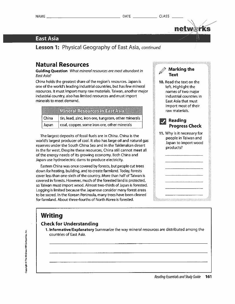
NAME DATE
____________
CLASS\.\
netw.@rksEast Asia
Lesson 1: Physical Geography of East Asia, continued
Natural ResourcesGuiding Question What mineral resources are most abundant inEast Asia?
China holds the greatest share of the region’s resources. Japan isone of the world’s leading industrial countries, but has few mineralresources. It must import many raw materials. Taiwan, another majorindustrial country, also has limited resources and must importminerals to meet demand.
China tin, lead, zinc, iron ore, tungsten, other minerals
[japan j coal copper some iron ore other minerals
The largest deposits of fossil fuels are in China. China is theworld’s largest producer of coal. It also has large oil and natural gasreserves under the South China Sea and in the Taklimakan desertin the far west. Despite these resources, China still cannot meet allof the energy needs of its growing economy. Both China andJapan use hydroelectric dams to produce electricity.
Eastern China was once covered by forests, but people cut treesdown for heating, building, and to create farmland. Today, forestscover less than one-sixth of the country. More than half of Taiwan iscovered in forests. However, much of the forested land is protected,so Taiwan must import wood. Almost two-thirds of Japan is forested.Logging is limited because the Japanese consider many forest areasto be sacred. In the Korean Peninsula, many trees have been clearedfor farmland. About three-fourths of North Korea is forested.
Marking theText
10. Read the text on theleft. Highlight thenames of two majorindustrial countries inEast Asia that mustimport most of theirraw materials.
IReadingProgress Check
11. Why is it necessary forpeople in Taiwan andJapan to import woodprod ucts?
WritingCheck for Understanding
1. Informative/Explanatory Summarize the way mineral resources are distributed among thecountries of East Asia.
3CU
I
3
2
CU
Reading Essentials and Study Guide 161

NAME
_________________________________
DATE
___________
CLASS
_____
Southwest Asia
Lesson 1: Physical Geography of Southwest Asia
ESSENTIAL QUESTIONHow does geography influence the way people live?
0E
a0
U-)
Terms to Knowalluvial plain an area built up by rich fertile soil left by river floodsoasis an area in a desert where underground water allows plants to grow year-roundwadi a dry riverbed in a desert that fills with water when rains fallsemiarid somewhat dry
Where in the World: Southwest Asia
L I
Reading Essentials and Study Euide 207

NAME DATE
___________
CLASS
netw©rksSouthwest Asia --- I”Lesson 1: Physical Geography of Southwest Asia, continued
Southwest Asia’s Physical FeaturesGuiding Question What are the main landforms and resources inSouthwest Asia?
Mountains and plateaus dominate the landscape of SouthwestAsia. They have been created over the past 100 million years bycollisions between four tectonic plates. This has also causedearthquakes in the region.
The region’s highest mountains are the Hindu Kush range. Itstretches across much of Afghanistan and along that country’sborder with Pakistan in South Asia. Mountain ranges form naturalbarriers to travel and trade. As a result, mountain passes areimportant in this area. One of the most famous is the Khyber Pass,between Afghanistan and Pakistan. It has served as a route fortrade and invading armies for thousands of years.
Plateaus cover much of Iran. Mountains in western Iran mergewith those of eastern Turkey. The Anatolian Plateau spreads acrosscentral and western Turkey. The Arabian Peninsula is a single, vastplateau. Long mountain ranges that lie parallel to the peninsula’scoasts are actually the deeply eroded edges of the plateau.
Southwest Asia takes its physical shape mainly from the bodiesof water that surround it. Turkey has coasts on the Mediterraneanand Black Seas. Syria, Lebanon, Jordan, and Israel have coasts onthe Mediterranean Sea. Jordan, Saudi Arabia, and Yemen borderthe Red Sea. The Red Sea has been one of the world’s busiestwaterways since the opening of Egypt’s Suez Canal in 1869. In thesoutheastern Arabian Peninsula, Yemen and Oman have coasts ona part of the Indian Ocean called the Arabian Sea.
In the northeast, the Arabian Peninsula is shaped by the PersianGulf. It is connected to the ocean by a strategic waterway calledthe Strait of Hormuz. The Persian Gulf has become very importantin world affairs since the middle of the 1900s. Eight of the region’s15 countries border the Persian Gulf.
• Oman • Iraq • Iran
• Bahrain • Kuwait • Qatar
• Saudi Arabia United Arab Emirates
In the north, Iran also borders the landlocked Caspian Sea. TheDead Sea, between Israel and Jordan, is also landlocked. At 1,300feet (395 m) below sea level, it is the world’s lowest body of water.Its shore represents the world’s lowest land elevation.
U Explaining
1. Where is the KhyberPass, and why is itimportant?
‘‘ Marking theText
2. Read the text on theright. Highlight thebodies of water thatborder Southwest Asia.
DrawingConclusions
3. Why do you thinkthe Strait of Hormuzis strategicallyimportant?
j Describing
4. What makes the DeadSea distinct?
n
I
3•0
208 Reading Essentials and Study Guide

NAME DATE
___________
CLASS
_____
\ /ewo
Southwest Asia .•-‘
Lesson 1: Physical Geography of Southwest Asia, continued
Southwest Asia’s two longest and most important rivers are theTigris and the Euphrates. They are often considered part of thesame river system. They begin in the mountains of eastern Turkey.In their lower courses, they flow parallel to each other through analluvial plain. This is a plain created by sediment deposited duringfloods. The plain covers most of Iraq as well as eastern Syria andsoutheastern Turkey. This area has been known since ancient timesas Mesopotamia, which is Greek for “land between the rivers.”
Deserts spread across much of Southwest Asia. The ArabianDesert covers nearly the entire Arabian Peninsula. It is the largestdesert in the region, and includes many landscapes, includingsand seas, which are unbroken expanses of sand. The largest sandsea in the world is the Rub’ al-Khali, or Empty Quarter, in thesouthern part of the peninsula. The climate is so dry that there areno permanent human settlements. In some areas, nomadic peopleknown as the Bedouin keep herds of camels, horses, and sheep.There are oases ir the Arabian Desert. These are areas whereunderground water allows plants to grow.
Southwest Asia’s Climates
Identifying
5. What is the Rub’aI-Khali?
ReadingProgress Check
6. How has tectonicactivity helped shapelandforms inSouthwest Asia?
Defining
7. Describe the differencebetween an oasis anda wadi,
Guiding Question What are some ways that mountains, seas, orother physical features affect climate in Southwest Asia?
Most of Southwest Asia has an arid, or very dry, climate. Desertscover nearly the entire Arabian Peninsula as well as large partsof Iran. Temperatures can rise to 129°F (54°C). When rains come,torrents of water race through wadis, or streambeds that are drymuch of the year. Seeds sprout within hours, turning the plainsgreen. Areas along the edges of the dry zones are semiarid, orsomewhat dry. These are found in highlands and mountain ranges.
Along the region’s Mediterranean and Aegean coasts and acrossmuch of western Turkey, the climate is Mediterranean. There are mildtemperatures and moderate rainfall in the winter Summers are warmand dry. The mountains of eastern Turkey, western Iran, and centralAfghanistan have continental climates. Temperatures vary greatly 8.between summer and winter. The mountains of the Hindu Kush have
. a highland climate. Glaciers are found among their high peaks.
Natural ResourcesGuiding Question How do natural resources influence the lives ofpeople in Southwest Asia?
Scarcity of water has shaped Southwest Asia’s human history and1’ settlement patterns. The region’s most important resources are oil
and natural gas.
IJ
ReadingProgress Check
In what parts ofSouthwest Asia canfarmers probablygrow crops withoutirrigation?
Reading Essentials and Study Guide 209

NAME DATE CLASS
net.w©iksSouthwest Asia .—“ I\
Lesson 1: Physical Geography of Southwest Asia, continued
Marking theText
9. Read the text onthe right. Highlightrecent discoveries inAfghanistan that mayhelp it rise out ofpoverty.
ReadingProgress Check
10. Five countries thatborder the Persian Gulfhold more than halfthe oil that has beendiscovered in theworld. Name threeof the countries.
Natural Gas Gaseous form of petroleum
r ilCrude Oil Gasoline; diesel, heating, and
J L industrial oil; plastics, cloth fibers
The world’s largest known deposits of petroleum are inSouthwest Asia. Most of them are concentrated around and underthe Persian Gulf. Five countries that border the gulf—Saudi Arabia,Iran, Iraq, Kuwait, and United Arab Emirates—hold more than halfthe world’s known oil. These countries export most of their oilto industrialized countries. Petroleum revenues have broughttremendous wealth to a few people in the exporting countries.Only in a few areas, how ever, has the wealth been used toimprove the lives of the people or to bring about modernization.
The region boasts a great variety of mineral resources. Turkeyand Iran have significant deposits of coal. Phosphates, which areused in fertilizers, are mined in Iraq, Israel, and Syria. Between2006 and 2010, American geologists in Afghanistan discoveredenormous deposits of many minerals. Among them were iron,copper, gold, cobalt, lithium, and rare earth elements used tomake electronic devices.
-4
I
3
WritingCheck for Understanding
1. Informative/Explanatory What are the major physical features of Southwest Asia?
2. Informative/Explanatory How has petroleum affected the countries that export it?
210 Reading Essentials and Study Guide

NAME
_________________________________________
DATE
_______________
CLASS
__________
Geography and Economics Activity netw:rksAsia
Oil Reserves Around the WorldOil is a natural resource that people rely on to provide conveniences. Sincethe invention of the automobile, oil has been used to make gasoline topower our cars. Before that, oil was used in lamps to provide light before theinvention of electricity.
Oil Reserves
Oil comes from the remains of once-living plants and animals. Over millionsof years, the organisms decayed and mixed with layers of sediment. Heatand pressure turned the materials into oil. Many oil deposits are locateddeep within Earth, sometimes under oceans. Oil reserves usually extend overa large area; some are hundreds of miles across.
World Oil Reserves
Saudi Arabia 17.85 Libya 3.15
Venezuela 14.35 Nigeria 2.53
Canada 11.91 Kazakhstan 2.04
Iran 9.31 Qatar 1.72
Iraq 7.82 United States 1 .41
Kuwait 7.07 China 1.01
United Arab Emirates 6.65 Brazil 0.87
Russia 4.08
__________________ _______
Source: CIA World Foctbook, Energy Information
Administration, Department of Energy
Finding and Recovering Oil
Companies may drill oil wefls across an area to remove the oil from theground. They may also drill exploratory wells to find the extent of an oilreserve. How do scientists find new oil reserves? They use a variety oftechnologies. For example, they may use satellites to locate rock formationsthat have the conditions scientists know are most likely to indicate thepresence of oil reserves.
S
03V
1
Country Percent of Country Percent ofWorld Total World Total

NAME
_________________________________________
DATE
_______________
CLASS
__________
/ ——\ / —
Geography and Economics Activity cont. netw:rks
To remove oil from underground reserves, companies can sometimes rely onunderground pressure to force oil to the surface. Over time, that pressureweakens, forcing companies to use pumping systems to bring oil to thesurface. Occasionally, the oil may be too heavy to flow, so companies mustdrill a second hole into the reservoir. They force steam through the hole intothe reservoir, which then thins the oil and pushes it to the surface.
To drill for oil under the ocean, companies build oil rigs on large platformson the water. To extract oil from reserves that are belowground, the landaround the area must be leveled and roads must be built for crews to accessthe area. Water wells may need to be dug so that water supplies can be usedin the drilling process. Holes are dug in the ground, and oil-rig systems areplaced over the main hole to extract the oil. Pumps, pipes, motors, and alarge support structure, called a derrick, are needed to get the oil out of theground. The process of extracting oil from the ground is expensive, as is theprocess of refining the oil. During the oil-refining process, impurities areremoved.
Oil Prices and Conflicts
Oil can be quite expensive. The price depends on where the oil is found, thedemand for the oil, and the amount of oil available. After a large storm atsea, for example, oil derricks may be damaged and drilling cannot take placethere until repairs are made. This may make less oil available for a while, sothe prices may go up.
Countries that have large supplies of oil can export the oil to other countries.As an example, the United States relies heavily on countries such as SaudiArabia to provide it with the oil that is needed for its citizens. If feuds occurbetween the countries, the supply of oil may be affected, and both countrieswill see the effects. The country selling the oil will not make money from asale. The country buying the oil will not be able to supply it to those whoneed it. Conflicts over oil sometimes develop, and nations must resolvethem quickly to continue to make this valuable resource available. Peoplearound the world are dependent on oil because the gasoline they use intheir cars is made from oil.
0•0
0
0
CD
03
•0
2
NAME
___________________________________________
DATE
________________
CLASS
__________
\ /Geography and Economics Activity cont. netw@rké
Thinking Economically
Directions Use the text to answer the following questions
1. Determining Central Ideas How is oil formed?
2. Explaining Why is finding and drilling for oil difficult and expensive?
3. Drawing Conclusions Why do you think finding new sources of energy isimportant for the future?
0
L0
0
-4S.
0
3


NAME
_____________________________________________
DATE
_________________
CLASS
___________
/Cultural Geography Activity netw r SAsia
_____________
AnimeHave you ever drawn a comic strip? If your characters had big eyes and bighair, chances are you’ve been influenced by anime. Anime is Japaneseanimation. It came to life following World War II, when a young artist namedOsamu Tezuka published the book Shintakarajima, or New Treasure Island.Later, he adapted his work to films and television shows. Tezuka isconsidered the father of anime. He influenced generations of artists to come.He, in turn, was heavily influenced by early Disney films, such as Snow White.
Like many Disney characters, Tezuka’s characters had big, round eyes—thebetter to express emotion.The females had big hair, and the males had bigmuscles. These artistic conventions are still part of anime today.
In the United States, cartoons are often lighthearted and geared to children.In Japanese anime, topics can be dark and bleak. The art form covers allgenres, including drama, action, romance, and comedy. Anime is for bothchildren and adults, giving it widespread appeal.
Although anime has a huge following among American youth, its culturalroots are still firmly in Japan.The gestures used by the characters reflectJapanese conventions. For example, Americans might gesture to their chestto indicate themselves. The Japanese would point to their nose. Othercommon gestures in anime include putting a hand to the head to indicateembarrassment and waving the hand quickly to signify no.
Directions: Use the text to answer the following questions.
1. Naming Who is considered the father of anime?
2. Citing Text Evidence Why do characters in anime have big eyes?
3. Comparing and Contrasting How does Japanese anime differ from Americancartoons?
4. Creating Visuals Draw a three-panel storyboard for a scene in an anime filmbetween two characters.
30
1

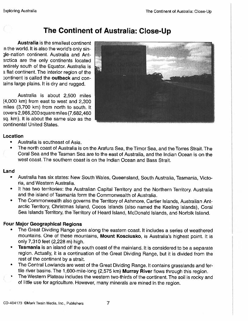
Exploring Australia The Continent of Australia: Close-Up
The Continent of Australia: Close-Up
Australia is the smallest continentn the world. It is also the world’s only sinle-nation continent. Australia and Antarctica are the only continents located3ntirely south of the [quator. Australia isa flat continent. The interior region of thecontinent is called the outback and conLains large plains. It is dry and rugged.
Australia is about 2,500 miles(4,000 km) from east to west and 2,300miles (3,700 km) from north to south. Itcovers 2,966,200 square miles (7,682,460sq. km). It is about the same size as thecontinental United States.
Location• Australia is southeast of Asia.• The north coast of Australia is on the Arafura Sea, the Timor Sea, and the Torres Strait. The
Coral Sea and the Tasman Sea are to the east of Australia, and the Indian Ocean is on thewest coast. The southern coast is on the Indian Ocean and Bass Strait.
Land• Australia has six states: New South Wales, Queensland, South Australia, Tasmania, Victo
ria, and Western Australia.• It has two territories: the Australian Capital Territory and the Northern Territory. Australia
and the island of Tasmania form the Commonwealth of Australia.• The Commonwealth also governs the Territory of Ashmore, Cartier Islands, Australian Ant
arctic Territory, Christmas Island, Cocos Islands (also named the Keeling Islands), CoralSea Islands Territory, the Territory of Heard Island, McDonald Islands, and Norfolk Island.
Four Major Geographical Regions• The Great Dividing Range goes along the eastern coast. It includes a series of weathered
mountains. One of these mountains, Mount Kosciusko, is Australia’s highest point. It isonly 7,310 feet (2,228 m) high.
• Tasmania is an island off the south coast of the mainland. It is considered to be a separateregion. Actually, it is a continuation of the Great Dividing Range, but it is divided from therest of the continent by a strait.
• The Central Lowlands are west of the Great Dividing Range. It contains grasslands and fertile river basins. The 1,600-mile-long (2,575 km) Murray River flows through this region.The Western Plateau includes the western two-thirds of the continent. The soil is rocky andof little use for agriculture. However, many minerals are mined in the region.
CD-404173 ©MarkTwain Media, Inc., Publishers 7

Exploring Australia The Continent of Australia: Knowledge Check
Name:
_______________
Date:
Knowledge Check
Matching
1. outback a. island off the south coast of Australia
2. Tasmania b. world’s smallest continent
3. Mount Kosciusko c. interior region of the continent
4. Australia d. major river that flows through the Central Lowlands
5. Murray e. Australia’s highest mountain
Multiple Choice Did You Know?
6. How much of Australia does the West- Australia is the world’s smallest continentem Plateau occupy? and the sixth largest country.
a. one-halfb. three-fourthsc. one-thirdd. two-thirds
7. How many major geographical regionsare found in Australia?
a. 4b. 7c. 5
V
d. 6ania
Constructed ResponseAustralia is surrounded by several bodies of water. Describe the location of these in relation toAustralia. Use details from the selection to support your answer.
cD-4o4173 ©MarkTwain Media, Inc., Publishers 9

NAME DATE CLASS
: /netw@rks
Oceania --- \Lesson 1: Physical Geography of Oceania
E0
z
0.
U
ESSENTIAL QUESTIONHow does geography influence the way people live?
Where in the World: Oceania
Terms to Knowcontinental island an island that was once connected to a larger continental landmassarchipelago a group of islandshigh island an island with steep slopes rising from the shore and higher landformslow island a relatively small, flat island with sandy beacheslagoon a shallow pooi in the center of an atollatoll a circular coral island surrounding a lagoon
Reading Essentials and Study Guide 293

NAME DATE
____________
CLASS
_____
\ /netw@rks
Oceania
Lesson 1: Physical Geography of Oceania, continued
Landforms of OceaniaGuiding Question How did thousands of islands appear across thePacific Ocean?
There are an estimated 10,000 islands in Oceania. Most of them
are small, and many are uninhabited. Geographers divide theregion into three sections, according to culture and physical
location. These sections are shown in the chart below.
Micronesia northwest section, east of the Philippines: FederatedStates of MronesPalau, Guam, Marshafl Islands
Melanesia south of Micronesia, east of Australia: New Guinea,Solomon Islands, Vanuatu, Fiji, Tonga, Samoa
Polynesia central Pacific Ocean: French Polynesia, Kiribati,Niue, the Hawaiian Islands, the Cook Islands
The islands range in size from New Guinea, which is 303,381
square miles (785,753 sq. km) to tiny islands covering less than
1 square mile (2.6 sq. km). Some, such as Fiji and Palau, areindependent countries. Others, such as American Samoa and
Guam, are overseas territories under the rule of other countries.
Australia, England, France, New Zealand, and the United States
have territories in Oceania.
New Guinea is the largest island in Oceania. It is a continental
island, meaning it was once connected to a larger continental
landmass. When sea levels were lower, it was a part of Australia.
Now it is part of the Malay Archipelago. An archipelago is a group
of islands. New Guinea is divided into two parts. The western part
belongs to Indonesia. The eastern part is an independent country
called Papua New Guinea. Only Papua New Guinea is considered
part of Oceania. In this discussion, we will refer to the entire island
as Papua New Guinea. The island has a great many Iandforms.
Rugged mountain peaks and glaciers dominate the center of the
island. There are low mountains and fertile river valleys in the
north, and a northern coastal plain. In the south, swampy lowlands
lead to the Owen Stanley Range.
Oceania includes several types of smaller islands. High islands
have steep slopes rising from the shore, higher Iandforms, and
diverse plant and animal life. They are usually the greenest of the
small islands. Fertile soil and humid and rainy climates allow dense
rain forests to grow. Many have freshwater streams, rivers, and
waterfalls. Tahiti and the Hawaiian islands are high islands.
Marking theText
1. Read the text on theright. Highlight thenames of countriesthat have territoriesin Oceania.
Defining
2. Why is New Guineacalled a continentalls/and?
fl Describing
3. What is the differencebetween New Guineaand Papua New Guinea?
Comparing andContrasting
4. In what ways are lowislands and high islandsalike and different?
294 Reading Essentials and Study Guide
=
1,C3

NAME DATE
___________
CLASS
_____
\
netw©rksOceania ---
Lesson 1: Physical Geography of Oceania, continued
Most high islands of Oceania were formed by underwatervolcanoes. As lava from erupting volcanoes flowed into the oceanwaters, it cooled and formed large mounds of volcanic rock.Eventually the volcanic rock built up above the water’s surface,forming high islands.
Low islands are small, flatter islands with sandy beaches. Theytend to have fewer forests and less diverse plant and animal life.Most of the islands of Micronesia and Polynesia are low islands.Some of them are so low that they just break the water’s surface.The island country of Tuvalu is so low that it is being eroded byocean waters. If sea levels continue to rise, Tuvalu and Oceania’sother lowest islands will disappear under the water.
Low islands were formed from coral reefs circling underwatervolcanoes. These reefs eventually grew above the water’s surface.In the center of these reefs were shallow pools called lagoons. Asthe reefs aged and crumbled, ocean waves deposited sediment onthe coral remains, forming an atoll. An atoll is a coral island madeup of a reef island surrounding a lagoon.
Climates of OceaniaGuiding Question What factors affect climate in Oceania?Nearly all of Oceania is located within the Tropics. Thus, most ofthe islands have warm, humid, tropical climates. Those outside theTropics have mixed tropical and subtropical climates. Some islandsexperience local climate variations caused by elevation, winds, andocean currents.
Papua New Guinea has two climate zones: tropical and highland.The highland regions are much cooler. The climate is wet. Februaryhas the most rain, and July has the least. Monsoon rains are common.Much of the island is covered in trees and other forest plants. Thereare, however, occasional droughts caused by the El Niño effect.
Temperatures on the smaller islands of Oceania are generallywarm throughout the year. They receive large amounts of rain.
4 Seasonal rainfall patterns determine an island’s wet season. That isthe time of the year when the heaviest rains fall. Islands north of theEquator, such as the Marshall Islands and Palau, have a wet seasonfrom May to November. Islands south of the equator, such as Samoaand Tonga, have a wet season from December to April. Theserainfall patterns occur under normal conditions. Heavy rains can alsobe caused by storms such as typhoons. Typhoons cause high windsand powerful waves that can topple trees and houses and erodeshores. The only small island affected by monsoon winds is Yap.
ReadingProgress Check
5. What are the names ofOceania’s sections?
: Marking theText
6. Read the text on theleft. Underline thesentence that tells howEl Niño affects one ofthe countries in Oceania.
Analyzing
7. What factors affect theclimates of Oceania?
ReadingProgress Check
8. The Northern MarianaIslands experience awet season from Mayto November. Based onthis information, arethe Northern MarianaIslands located north orsouth of the Equator?
Reading Essentials and Study Guide 295

NAME DATE
___________
CLASS
_____
\\ /
netwrksOceania I”Lesson 1: Physical Geography of Oceania, continued
Analyzing
9. Why are there fewnatural resources onlow islands?
:; Marking theText
10. Read the text on theright. Underline thesentence that describesproducts fromOceania’s high islands.
ReadingProgress Check
11. What are two types ofrenewable resourcesin Oceania?
Resources of OceaniaGuiding Question What natural resources do the islands ofOceania possess?
Since most of Oceania’s islands are small, the amount of natural
resources is limited. In spite of this, they have some valuable
resources. Those that are sold or traded are essential to theislands’ economies.
The nation of Papua New Guinea has many natural resources. It
has large natural gas reserves for its size. They have the potential
to benefit the nation’s economy.
/ :/ -
gold timber petroleum
copper fish natural gas
Oceania’s smaller islands have few natural resources that can
be traded on the international market. Limited land area is onereason. Low islands, based on coral, do not have rock foundations.
It is in deep layers of rock that deposits of metal ores are found.
New Caledonia is developing wind power. That form of power
is also spreading to other islands. Kiribati and the Solomon Islands
have begun using solar-powered lighting in their homes. Wind
and solar energy are renewable, nonpolluting resources. Because
of the sunny climates and ocean winds, these resources areplentiful throughout Oceania.
Some of the high islands have trees that are used for timber,
rubber, and other products. Soil quality varies from island toisland. Some islands have rich volcanic soil for growing farm crops.
Other islands have poor-quality soil, which makes farming difficult.
Fish and other seafood are important resources. Most islands use
fish only for their own food, not for export.
nt
-4
n0
WritingCheck for Understanding
1. Informative/Explanatory How did thousands of islands appear across the Pacific Ocean?
296 Reading Essentials and Study Guide

NATIVE AUSTRALIANS
Exercise 4: Complete the text with the words below.
krat0M
“d
Spread(J,.
‘IOnoc%
(F tribe preserved
It is believed that Aboriginals, who settled in Australia, came from Indonesia around 50,000 years ago. The oldest Aboriginal
L _fD fl that was found dates back over 38,000 years and traces of C,e-r,yY) ‘fl & I paint were found
on the bones. There were over 600 different aboriginal ±1 , which all spoke different languages and only
met each other on C,e.rL41I 0 fl I S or other special occasions.
Most Aboriginals were fl0 YY) L’t ,they would move to different parts of the country and return to specific places
to f their dead. These special places were sacred because the aborigines associated them with the
‘Dreamtime’. They believed that the ‘Dreamtime’ is the time when the earth was Y Yh c. and the beginning of
life. Since the Aboriginals had no written language, it is difficult to really understand their meaning of the ‘Dreamtime’. Some
Aboriginal legends and songs tell things about the I I who created their and. Rock paintings, which are
64 practically all over the country, also show this creation. Some rock paintings are well
12 rI_. ‘tY V’.”_cl and can be seen in museums and in the Kakadu National Park in northern Australia.
The arrival of C4’)) Ofl I 2.-€V6 and settlers brought an end to the way of life of the Aboriginals. The immigrants began
to build cities and farms on the land of the Aboriginals. Most Aboriginals today have 1A..4 &D4 ‘ to the Western
way of life and live in towns or cities. Only a few, however, continued their 1y.c&.’ 19 0 r’ ‘i I way of life and live in
isolated settlements near their original tribal lands.
In recent years, the Australian people have become more aware and sensitive to the ‘I 11A O...t9 Ofl of the Aboriginals.
The government invested in their health and educational services and greater Y. ii 41 0 1 of Aboriginal land rights.
Many people in Australia show their appreciation for Aboriginal art, musical instruments and artifacts.
Pirfreco
slut/on

Exercise 5: Choose the best answers far the questions below.
1) Aboriginals originally come from
a. Indonesiac. China
2) There are no Aboriginal scriptures because
o. They all got lost over time.
b. They hod no written language.
c. British colonizers destroyed them.
d. A and Core correct.
3) What is the ‘Dream Time’?
a. The afterlife of Aboriginols
c. The god ofAboriginois
4) Scientists study the ‘Dream Time’ by —.
Exercise 6: Unscramble the words below and find
them in the ward search.
INDI iENOUSDY
DFTAILARTSUA
YBYEXSNFJLOT
MZYZWqDRJRR
OFLLXUDHSJMI
LAN1 tROBAIB
CEREMONYRQQE
5) How many Aboriginal tribes currently live in Australia?
a. 50,000 b. 600
c. none d. not mentioned in the text
6) Most Aboriginal tribesa. Did not live in permanent settlements
b. Hove maintained their original way of life
c. Spoke the same language
d. None of the above are correct
7) How did the arrival of the colonizers change the life of
Aboriginals?a. They gradually adapted to a western lifestyle.
b. Much of their land was token away.
c. They all moved to isolated settlements.
d. A and B are correct.
8) How has the situation of Aboriginals changed in recent years?
a. They have become more isolated.
b. They hove became more appreciated.
1) oaesnirid
_____________________
Most Australian Aboriginal people originally come from
2) aetdrrwie
__________________
The formation of the Earth and the beginning of life.
3) wtseern
___________________
Most Aboriginal people have adapted to a lifestyle.
4) ritrpsiaSeveral rock can be seen in the Kakadu National
Park.
5) aauriIeAboriginal tribes did not have the same
6) aorvKtsr
___________________
Most Aboriginals were they were always on the
move.
7) trwiae
b. Tasmaniad. America
b. Aboriginal religiond. The beginning of life
a. songsc. paintings
b. legendsd. All of the above
ausriltaa ttslserweet etisrb
iitaanr’bo dnseiouru
ExercIse 7: Unscramble the words. Hints are given below.
rnyeocerv
CSETTLEMENTS
The Aboriginals are the people of Australia.

The MoonINDIGENOUS PEOPLE
The Maori are the indigenous people of New Zealand. The name Maori means
“ordinary people” in the Maori language. They were Pacific Islanders who
travelled from island to island with big canoes. The explorers used the position of
sun and stars and sea currents to navigate and find land. They arrived in the
country around 1,200 years ago and named it Aotearoa, which means “the Land
of the Long White Cloud”. Their arrival with canoes is known as the “Great Fleet”.
Once they settled in New Zealand, they became known as the Macri. They
formed their own culture, language and traditions.
They settled in the coastal areas of the North Island and began hunting animals. Initially, the
Macri lived in tribal groups. But soon, they moved to the forests and began farming.
The Maori have their own religion and believe in gods that represent the sky, earth and nature.
They also believe that the spirits of their ancestors can help them when they need it.
The haka dance is probably the best-known tradition of the Maoris. It is a ceremonial war dance
that is performed by a group, with vigorous movements, stamping of the feet and shouting.
Originally, warriors performed the dance before a battle. This was done to intimidate their
opponents and as a show of strength. Besides this, the dance was also performed on cultural
occasions such as welcoming guests, ceremonies and funerals. The New Zealand rugby team still
performs the dance before every match.
The arrival of European settlers in the l7’ century brought enormous
changes to the Maori way of life. There were many disputes between
the Maori and the Europeans, mostly about land possession. The treaty
of Waitangi was signed in 1840 between the Maori and the British. This
treaty promised the Maoris that they could keep their lands and would
have the same rights as the British settlers. Unfortunately, the Waitangi
Treaty did not prevent warfare between the Maori and the British. They
Macri became increasingly dissatisfied because they felt that the British
did not respect the land possessions. They strongly defended their land
and local authority.
There are 650,000 Maoris living in New Zealand today. Most of them live in the cities and have adopted a western way of living.
Around 30% of the Maoris still speak their ancestral language. It is the second official language of New Zealand and the basics are
taught in most schools. The Maori people and their culture are widely respected in New Zealand today.
oC
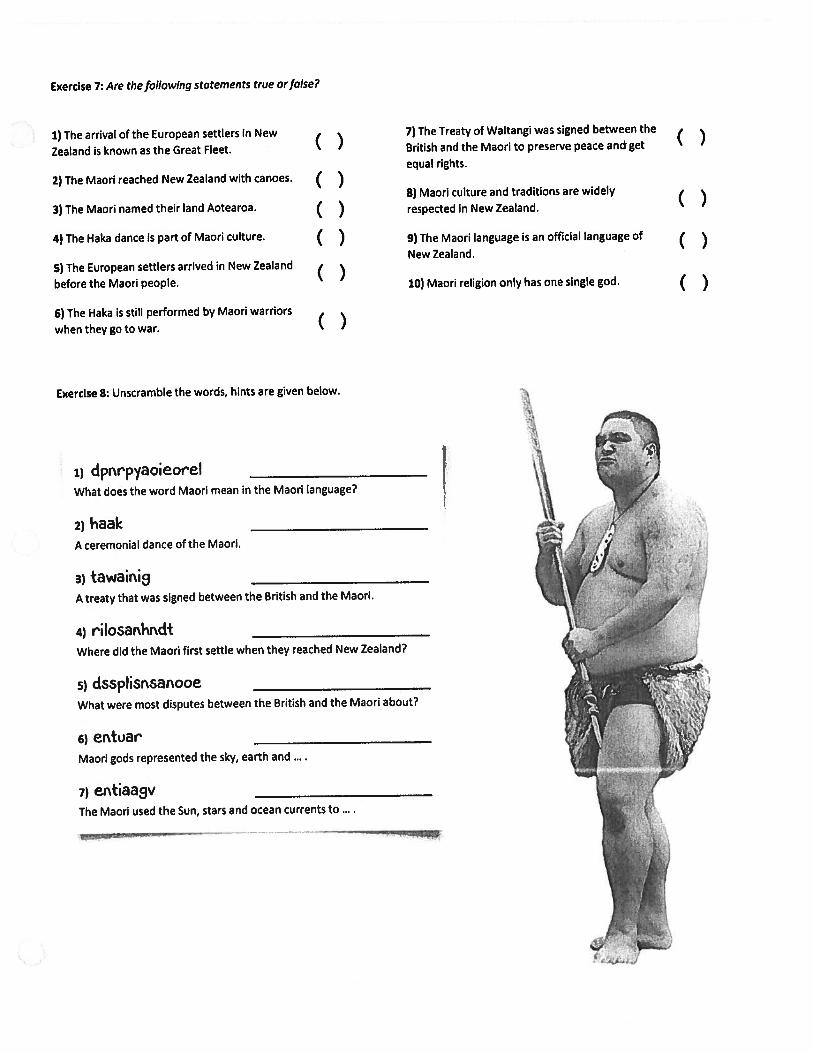
Exercise 7: Are the following statements true or false?
1)The arrival of the European settlers in New
Zealand is known as the Great Fleet.
2) The Maori reached New Zealand with canoes.
3) The Mann named their land Aotearoa.
4) The Haka dance is part of Maori culture.
5) The European settlers arrived in New Zealand
before the Maori people.
6) The Haka is still performed by Maori warriors
when they go to war.
Exercise 8: Unscramble the words, hints are given below.
1) dprr’pyaoieorelWhat does the word Maori mean in the Maori language?
2) haak
______________________
A ceremonial dance of the Maori.
3) tawaini
_____________________
A treaty that was signed between the British and the Maori.
4) riIosarbrdt
______________________
Where did the Maori first settle when they reached New Zealand?
5) dsspisnsanooeWhat were most disputes between the British and the Maori about?
6)ertoar
______________________
Maori gods represented the sky, earth and
7)entiaav
______________________
The Maori used the Sun, stars and ocean currents to
—.,‘
,7) The Treaty of Waitangi was signed between the
‘ British and the Maori to preserve peace and get
equal rights.
()8) Maori culture and traditions are widely
( ) respected in New Zealand.
( ) 9) The Maori language is an official language of ( )New Zealand.
10) Maori religion only has one single god. ( )
()

Expioring Antarctica The Continent of Antarctica: Close-Up
The Continent of Antarctica: Close-Up
Antarctica is the world’s southernmost continent. It surrounds the South Pole, which ishe earth’s most southern point. Its name means “opposite the Arctic.” The Arctic is the earth’siorthernmost region. Antarctica is approximately 600 miles (1,000 km) from South America, 2,500niles (4,000 km) from Africa, and 1,600 miles (2,500 km) from Australia.
Antarctica is the fifth-largest continent. It is larger than Australia or Europe. It is slightly lesshan one and one-half the size of the United States. The Transantarctic Mountains divide theontinent into two regions, West Antarctica and East Antarctica.
Because of Antarctica’s severe weather, it is the only continent that does not have any perrianent residents. Twenty-nine nations send scientists to several research stations located on theontinent. The population of the research stations varies from about 5,000 in the summer to 1,000
n the winter. In recent years, tourists have begun to visit the continent.
It is bitterly cold and almost completely covered by a huge sheet of ice. The ice is often twoniles thick near the center of the continent; it then thins out toward the coastline. This sheet con:ains about 90 percent of the world’s ice. Below the ice, the land area of Antarctica is about the sizejf Australia. Just over two percent of its area is exposed land. Much of the land that is exposed isliountaintops.
As snow falls in the central region, it forces the ice sheet to move very slowly toward thestlines. Often, when the ice reaches the water’s edge, it floats, creating an ice shelf. Antarcticaseveral ice shelves. The two largest are the Ross Ice Shelf and the Ronne Ice Shelf. The Ross
ce Shelf is about 4,000 feet (1,219 m) thick in places. Often, pieces break off the ice shelves and:orm icebergs.
Antarctica is surrounded by water, including the southern parts of the Atlantic, Pacific, and‘ndian Oceans. Sometimes, the waters off Antarctica’s coast are referred to as the Antarctic Oceanr the Southern Ocean. Also along its coasts are the Amundsen, Ross, and Weddell Seas.
Antarctica is the world’s highest continent. Its average elevation is over 6,500 feet (2,000 m)above sea level. Its highest point is Vinson Massif, which is 16,864 feet (5,140 m) high; its lowestDoint is on the Southern Ocean at zero feet (sea level).
Ice covering Lake Fryxell in the Transantarctic Mountains comes from the melting of the Canada Glacier.
ZD-404171 ©MarkTwain Media, Inc., Publishers 7

Exploring Antarctica The Continent of Antarctica: Knowledge Check
Name:
________________
Date:
Knowledge Check
Multiple Choice
6. Which continent is closest to Antarctica?
a. North Americab. South Americac. Africad. Australia
7. What is the population of Antarctica inthe summer?
a. about 10,000b. about 50c. about 5,000d. about 100
Did You Know?
Matching
______
1. Antarctica
____
2. ice shelf
____
3.
____
4.
Transantarctic Mountains
____
5.
Southern Ocean
creates this
a. ice reaching the water’s edge and floating
Vinson Massif
called this
b. the waters off Antarctica’s coast are sometimes
c. “opposite the Arctic”
d. Antarctica’s highest point
e. divides Antarctica into two regions
Scientists recorded the world’s coldest
I . temperature,128.6 degreesbelow zero(Fahrenheit),in Antarctica.
Constructed ResponseExplain the rlifferenr,e between an ice shelf and an iceberg. Use details from the selection tosupport your answer.
CD-404171 ©Mark Twain Media, Inc., Publishers 9

NAME DATE
___________
CLASS
_____
/netw@rks
Antarctica iLesson 1: The Physical Geography of Antarctica
aE
aC
ESSENTIAL QUESTIONHow does physical geography influence the way people live?
Where in the World: Antarctica
Terms to Knowice sheet thick layer of ice and compressed snow that forms a solid crust over an area of landice shelf thick layer of ice that is attached to a coastline and floats on the oceancalving process of ice breaking free from an ice shelf or glaciericeberg large chunk of floating ice that broke off from an ice shelf or glacierkatabatic wind powerful, cold wind that blows from the interior of Antarcticalichen organisms made up of algae and fungi that grow on rocky surfaceskrill tiny shrimp-like sea creatures that provide food to whales and many other sea creaturesplankton tiny organisms—algae or single-cell bacteria—that float near the water’s surface
Reading Essentials and Study Guide 305

NAME DATE
____________
CLASS
______
‘ /
netwrksAntarctica -‘ \
Lesson 1: The Physical Geography of Antarctica, continued
Landforms and Waters of AntarcticaGuiding Question Is Antarctica the last unknown land regionon Earth?
The continent of Antarctica is nicknamed the “last continent” and“the bottom of the world.” It lies more than 2,500 miles (4,023 km)south of the Tropic of Capricorn. It is the world’s fifth-largest
continent and is surrounded on all sides by the Southern Ocean.
The South Pole is located near the center of the continent.
Antarctica is the world’s highest continent. It has an averageelevation of 7,000 feet (2,134 m) above sea level. However, mostof the surface we can see is packed ice. Some of Antarctica’s
mountains rise above the ice, but most of the land is much lower.
In fact, the weight of this ice has forced some of Antarctica’ssurface land far below sea level.
The highest point in Antarctica is Vinson Massif, which reaches
16,066 feet (4,897 m) in height. The Transantarctic Mountains
divide the continent into East Antarctica and West Antarctica. Thelowest point is deep within the Bentley Subglacial Trench. This isthe lowest place on Earth that is not under seawater.
The ice sheet covering most of Antarctica is 2 miles (3.2 km)
thick in some places. An ice sheet is a thick layer of ice andcompressed snow that forms a solid crust over an area of land.This ice sheet covers 98 percent of Antarctica’s surface.
Ice extends into the ocean on ice shelves. An ice shelf is a thick
Defining slab of ice that is attached to a coastline but floats in the ocean.The size of the ice shelf changes year round, as shown below.
J Explaining
5. What causes an iceshelf to increase in
Explaining
1. Why is some ofAntarctica’s landbelow sea level?
Marking theText
2. Read the text andcircle the highestand lowest pointsin Antarctica.
Defining
3. What is an ice sheet?
4. What is an ice shelf?
size?
306 Reading Essentials and Study Guide
n0t
C’
n
3

NAME DATE
___________
CLASS
_____
/:netw©rks
AntarcticaLesson 1: The Physical Geography of Antarctica, continued
The process of ice breaking free from an ice shelf or glacier iscalled calving. The large chunk of ice that breaks off is called aniceberg, Icebergs are made of freshwater, not salt water. To becalled an iceberg, the chunk of ice must be at least 16 feet (5 m)across. As much as 90 percent of an iceberg remains underwater.This has led to accidents when ships have come close to whatappeared to be small chunks of ice. The ships then crashed intothe enormous, unseen parts of the icebergs.
Antarctica is surrounded by several seas: the Weddell Sea, theScotia Sea, the Amundsen Sea, the Ross Sea, and the Davis Sea.These were named by and for explorers and scientists whomapped and studied the region.
Climate and ResourcesGuiding Question Does any life exist on such a forbiddingcontinent?
Antarctica has an intensely cold climate. Because of its highlatitude, it never receives direct rays from the sun. Thus, verylittle heat energy reaches the land. In addition, for three monthsof the year, most of Antarctica receives no sunlight at all.
The high elevation also affects the climate. Strong, fast windsblow colder air down from high interior lands toward the coasts.These powerful gusts are called katabatic winds. They are drivenby Earth’s gravity. In addition, Antarctica has an extremely dryclimate. It only receives 2 to 4 inches (5 to 10 cm) of precipitationper year, making it the world’s driest continent.
Antarctica plays an important role in maintaining the globalclimate balance. Its ice covering affects the temperature of Earth,as shown below.
Antarctica’s harsh climate limits the types of plants and animalsthat can live on the surface. Only 1 percent of Antarctica’s land issuitable for plant life. Plants found here include flowering plants,mosses, algae, and lichens. Lichens are organisms that usuallygrow on solid, rocky surfaces and are made up of algae and fungi.Most plants grow on the Antarctic Peninsula and surroundingislands. These are the warmest and wettest places in the region.
Defining
Defining
6. What is the name ofthe process that formsicebergs?
Marking the‘ Text
7. Highlight the text thatexplains why icebergscause accidents.
ReadingProgress Check
8. Does the continent ofAntarctica increase insize during the winter?
Explaining
9. Why are there so fewplants in Antarctica?
a
z
a0
10. Name two types oforganisms that makeup lichens.
Reading Essentials and Study Guide 307

NAME DATE
____________
CLASS
_____
/
netw©’ksZ Antarctica
Lesson 1: The Physical Geography of Antarctica, continued
Marking the‘ Text
11. In one color, highlightthe life-form that seamammals and seabirdseat. In another color,highlight what is eatenby this life-form.
ReadingProgress Check
12. In your own words,explain why Antarcticahas such a cold, dryclimate.
Most land animals are tiny insects and spiderlike mites. Most
other land animals are only visitors, such as Weddell seals and
many species of shorebirds, such as albatross, cormorants, and
gulls. Only the emperor penguin stays year round. These giant
penguins have adapted to the cold temperatures and cannot
survive outside of Antarctica’s frozen climate.
Although the land is home to very few living things, the seas
are filled with life. Many kinds of seals, dolphins, fish, and other
marine animals live in the waters around Antarctica. Whales come
to the Southern Ocean to feed during the summer. Sea mammals
and seabirds eat krill, tiny crustaceans similar to shrimp. Krill thrive
in the Southern Ocean and feed on a smaller life-form called
plankton. These are tiny organisms such as single-celled bacteria
or algae that float near the water’s surface. Plankton, krill, fish, sea
mammals, seabirds, and land animals are all part of Antarctica’s
ecosystem. They are an essential part of the food chain that
supports life on the continent.
It is difficult or impossible to explore Antarctica for natural
resources. The harsh climate makes it dangerous for human
workers, and the land is buried by the thick ice sheet. As a result,
mineral and energy resources that might exist have not been
exploited. However, commercial fishing operations harvest fish
from the water.
Writing
Check for Understanding1. Informative/Explanatory How does Antarctica help lower Earth’s temperature?
t
xn0
2. Informative/Explanatory Explain why Antarctica’s mineral and energy resources are not
commercially mined or harvested.
308 Reading Essentials and Study Guide

NAME
_______________________________________
DATE
_______________
CLASS
_________
Geography and Economics Activity netw©rksAustralia, New Zealand, Oceania, and Antarctica - - \The Antarctic Treaty of 1959Imagine a place so cold and barren that very few people can even livethere—an entire continent that only about 4,500 people call home.That’s the population of Antarctica—but only in the summer. In thewinter, only about 1,100 people live on the entire continent.
Antarctica is not like any other place on Earth. The frigid temperatures anddriving winds make living there almost impossible, but the continent has a lotto offer. It has so much to offer, in fact, that the Antarctic Treaty of 1959 wasadopted to preserve the land and make it available only for scientific research.
The Antarctic Treaty of 1959 is still in effect today and states that thecontinent will be used only for scientific research and observations. Italso requires the land to be used only for peaceful purposes. The treatyimpacts more than just Antarctica. It directly affects the many countriesinterested in the resources and research capabilities the continentoffers. According to the treaty, no country is able to claim the territoryand possibly benefit from any riches or scientific data found there.In a way, the continent belongs to the world, and no one country caneconomically benefit from Antarctica’s resources. The treaty alsoaddresses the military, stating that no military bases can be built there,no military maneuvers can be performed there, and no weapons testingcan be done in the naturally preserved area.
The treaty was originally signed by 12 countries that had scientificresearch interest in the land. Today 50 nations are part of the treaty.Research about climate, ecosystems, temperature, and astronomy hasall taken place in Antarctica.
Does the Antarctic Treaty affect the region’s economy? Because of thesmall population, the continent does not need local businesses andimports and exports to survive. There is no need for corporations, malls,and other conveniences of modern culture. Research facilities are set upfor people and research equipment, and little else. For those reasons,the treaty does not impact the economy as it might in a place boomingwith this type of activity.
One industry is important, however. Antarctica’s fishing industry keepsthe economy active. Fishing off the coast is an important industry that isnot affected by the Antarctic Treaty. Toothfish, mackerel icefish, and krillare caught in the icy Antarctic waters and sold around the world. Thetreaty actually helps the economy in this instance because it ensuresthese resources will continue to be available in the future. The AntarcticTreaty is one document that preserves the most untouched continent onEarth and keeps it from being exploited for resources.
I

NAME
_________________________________________
DATE
_______________
CLASS
__________
N /
Geography and Economics Activity cont netw©rks
Australia, New Zealand, Oceania, and Antarctica --
Thinking Economically
Directions: Use the text to answer the following questions.
1. Summarizing Why do so few people live on the continent of Antarctica?
2. Making inferences Why do you think more people live in Antarctica in
summer than in winter?
3. Determining Central ideas What is the purpose of the Antarctic Treaty?
4. Explaining What is the main economic activity of Antarctica?
5. Drawing Conclusions Why do you think the Antarctic Treaty is important
to the world economy?
1.,
t
0
±
2

World GQograph9 On PagQrThis final project will give you the opportunity to share what you ‘ye learned this semester.You will incorporate the 5 Themes of Geography from the third quarter and the study of thecontinents from this quarter. There is an example on the back to help you but don ‘t copythe example. If you can ‘t access your notes on the 5 Themes of Geography, please call Ms.Schmidt at 715—513—9227 and I will mail you a copy of the notes. All notes are posted onGoogk Classroom.
One Pager Checklist1. ALL work must be done on only one side of your paper.2. Write your name on the backside of the paper.3. The title: World Geography must be clearly and creatively displayed.4. Create SEVEN visuals - one for each continent. Be creative! Label the visual
with the name of the continent.5. Incorporate details about the continents by selecting one of the 5 Themes of
Geography (Location, Place, Human Environment Interaction, Movement, Region) foreach continent. You will use two themes twice. Share three facts about where or howthat theme could be found on that continent.
6. Place/Write/Draw a vocabulary word (list of vocabulary words on the back)that matches the theme.
7. Be colorful and neat.8. Use ALL of the space on the paper. There should be no large empty spaces.9. Feel free to use colored pencils, markers, magazine cutouts, print out images,
etc.
geography cWord of the Daygeography cartographer physical map political map globelatitude longitude equator prime meridian map projectionC4LdOLJI.4l.’..., IJ’_,CAtI..’. I LL.4LI%... %1.(.ASI..da LLI.an.ALI %.. LI
I._.j_.LU SL_)LL U%_.
Mercator Projection landforms climate vegetation peninsula straitarchipelago channel plateau canal delta oasistributary isthmus foothills conservation environmentendangered interaction impact (verb) adapt erosion faminefossil fuel extinct immigrate emigrate migrate alien currencysociety literacy rate gross domestic product mortality rate capitalismdemocracy dictator regime communismconstitutional monarchyauthoritarian foreign policy sanctions treaty indigenous anthropologyinflation Judaism religion Christianity Islam Buddhism Hinduism

2-‘3-
Dc) ‘‘—.
——r
.r 6(Jj
*
‘/i’zc—
3
0
C0
l__-
.3
2:;;:
0
?•-.--
ccS)
.—‘qj
t.0
E.
-
(•)3-
-
1
-
C’
c•.-i
••-
cI.‘
I(J..-.‘..-.c.•—
•—d0
.
-—“(S°•,(_)(-,—
,
c.-’(
--<C.r
d,‘
oç. _?_..—
c-OI:c)F-
•6•c,’-’Cs-
4
I
0
I
41
3
4
•,___0
*S
-
-Cqi,
4;
Y—
!-4g
4. 93-.
‘F ‘1_,.—
.:IF—
1
0.
cr4)
0
-0
-
0
5;cS
/-S.
C
Zn‘,1
q.)
C)Y ç-.c
•-
: -rC:y__)
cz•C_)
.‘1
.Co•Atc-v5’
Ai4,ccS:j
br.-
•‘H—Z)
-,
(;.
(0q)..
c2-
.7
-0J(4
cc-)
c
1ai
-4*
-‘II)
-II
1’
c::if
---*
,-(_—
6•
_çi
4?c0
•CDci)c-’-(
-•(-•(c)‘
(S
-Th

•Z.L
n
/
—-
.-.Ci—
r-
---
••__i
-,-—
C
7--.--
:1
-)
_
6-:-
)-:‘L2/
c10‘
——-I
C—
-‘--
-1
*3
/\II
N
C—
J
C—
IJ-
—--‘—
—-
a-A
‘),
C-4-.
-
--,jI
.0--
/
3-‘3
--
-:1—a—
V))
--;v:3 A
—
1
--
-;2
::
—-IJ
q