Embed Size (px)
Citation preview

Working with Natural Processes to
Manage Flood and Coastal Erosion Risk
A Guidance Document – March 2010

We are the Environment Agency. It's our job to look after
your environment and make it a better place - for you, and
for future generations.
Your environment is the air you breathe, the water you drink
and the ground you walk on. Working with business,
Government and society as a whole, we are making your
environment cleaner and healthier.
The Environment Agency. Out there, making your
environment a better place.
Published by: Environment Agency Rio House Waterside Drive, Aztec West Almondsbury, Bristol BS32 4UD Tel: 0870 8506506 Email: [email protected] www.environment-agency.gov.uk © Environment Agency All rights reserved. This document may be reproduced with prior permission of the Environment Agency.
This document has been produced by a Working Group with
representatives from:
Defra RSPB
Environment Agency The River Restoration Centre
National Trust Wildfowl & Wetlands Trust
Natural England Wildlife Link
The assistance of Stuart Hedgecott (Halcrow Group Ltd) in compiling case
study information is gratefully acknowledged.

Contents Page
Executive summary 4 1. Introduction 5 2. What is meant by working with natural processes? 6 3. Drivers for working with natural processes 9 4. Techniques for working with natural processes 11 5. Case studies 16 6. References and further reading 64
Glossary of terms 66
Appendix 1 Long list of case studies 68
Appendix 2 Project appraisal checklist 73

Working with natural processes to manage flood and coastal erosion risk
Page 4 of 74
Executive summary This document illustrates how flood and coastal erosion risk management can work more
with natural processes. It defines what is meant by this and outlines the key policy reasons
why this should happen. It describes a broad range of techniques for working with natural
processes in all areas of a catchment – upland, lowland, urban, rural, and coastal. Case
studies are provided that illustrate where these techniques have already been used.
Working with natural processes means taking action to manage flood and coastal erosion
risk by protecting, restoring and emulating the natural regulating function of catchments,
rivers, floodplains and coasts. This could for example involve using land to temporarily store
flood water away from high risk areas, reconnecting rivers to their floodplains, and
lengthening watercourses to a more natural alignment. Managing upland areas by, for
example, restoring degraded peat bogs or blocking artificial drainage channels and
reforesting floodplains will also help to slow run-off and increase infiltration. In urban areas
green roofs, permeable paving, surface water attenuation ponds, opening up and realigning
watercourses, and establishing blue corridors are equivalent examples.
This guidance has been produced by a working group set up to deliver a recommendation of
the Pitt Review (recommendation 27) that the Environment Agency and others should work
together to achieve greater working with natural processes to manage flood and coastal
erosion risk. It is aimed at those who commission schemes or develop strategies and plans
to manage flood and coastal erosion risk. It will also be of use to those who seek to influence
such strategies and schemes so that opportunities to work more with natural processes are
fully considered in project appraisal.
The guidance will help project managers and others when selecting options and designing
schemes to decide which of the techniques will best enable them to deliver greater working
with natural processes. It should be used to supplement the Environment Agency‟s project
appraisal guidance which reflects Government policy on the appraisal of publically funded
schemes in England.
The Pitt Review recognised that working more with natural processes does not mean that
traditional hard defences will not be needed but that more sustainable approaches should
work alongside them. This is in line with the Making Space for Water consultation and the
Government intention to use a wider portfolio of responses to manage risk. The Defra policy
statement on the principles that should guide decision making in the sustainable
management of flood and coastal erosion risk identifies that an understanding of natural
processes is important to ensure that the impacts of different options are properly appraised
and opportunities to work with nature to reduce risk are identified. This guidance is part of
the evidence base to deliver that understanding.

Working with natural processes to manage flood and coastal erosion risk
Page 5 of 74
Section 1 Introduction
This document illustrates how flood and coastal erosion risk management can work more
with natural processes. It defines what is meant by this and outlines the key policy and legal
reasons why this should happen. It lists a range of techniques for working with natural
processes and gives real examples which illustrate where this has been successful. It will
help project managers and others when selecting options and designing schemes to decide
which of the methods available will best enable them to deliver greater working with natural
processes.
The guidance is aimed at those who commission and design flood and coastal erosion
schemes or develop strategies and plans to manage flood and coastal erosion risk. It will
also be of use to those who might want to influence such strategies and schemes so that
opportunities to work more with natural processes are fully considered in project appraisal.
Treasury guidance1 requires publicly funded schemes to show, through a process of project
appraisal, that they represent good value for money and are an efficient use of resources.
Defra have issued a policy statement on the appraisal of schemes, which guides decisions
on the sustainable management of flood and coastal erosion risk in England2. The
Environment Agency has recently published more specific best practice guidance on how to
undertake appraisals. This document should be used to support that appraisal guidance.
This guidance has been produced be a collaboration of different organisations (see front
cover). It is part of the output of the working group lead by the Environment Agency, set up
in response to the Pitt Review recommendation: “Defra, the Environment Agency and
Natural England should work with partners to establish a programme through Catchment
Flood Management Plans and Shoreline Management Plans to achieve greater working with
natural processes.” 3 It also contributes to the achievement of Government‟s vision for flood
and coastal risk management that sustainable development will be firmly rooted in all
operations and decisions. This should manifest itself through more schemes working with
natural processes4.
Updates to this document
To allow for further feedback during initial use of this guidance, it is presented as a living
draft for review. As a living draft we would very much welcome your comments and
experiences in order to update and re-issue this guidance. Please send your feedback, in
particular any details of other case studies, to [email protected] which will be open to
30th September 2010.
After 30th September 2010 any feedback will be reviewed, and revised guidance will be published on the Environment Agency website.
1 Appraisal and Evaluation in Central Government. (HM Treasury, 2009)
2 Appraisal of flood and coastal erosion risk management. A Defra policy statement (Defra, 2009a)
3 See recommendation 27 of the Pitt Review: Lessons learned from the 2007 floods (Cabinet Office,
2008) 4 See vision in Making Space for Water (Defra, 2005)

Working with natural processes to manage flood and coastal erosion risk
Page 6 of 74
Section 2 What is meant by working with natural
processes?
Working with natural processes means taking action to manage flood and coastal erosion
risk by protecting, restoring and emulating the natural regulating function of catchments,
rivers, floodplains and coasts5.
It is now widely accepted that flood risk cannot simply be managed by building ever bigger
and taller „hard‟ flood defences. More sustainable „softer‟ approaches must be considered.
This is reflected in the Government strategy for flood and coastal risk management – Making
Space for Water – which says that the concept of sustainable development must be firmly
rooted in all flood risk management and coastal erosion decisions and operations. This will
manifest itself on the ground in the form of more flood and coastal erosion solutions working
with natural processes. More space will be made for water in the environment through, for
example, appropriate use of defence realignment to widen river corridors, multi-functional
wetlands that provide wildlife and recreational resource, and more saltmarsh and mudflats
that enhance coastal defences6 7.
The Pitt Report: Learning Lessons from the 2007 floods – published in June 2008 –
recognised that working more with natural processes does not mean that more traditional
hard defences will not be needed, but that more sustainable approaches should work
alongside them. The approach should complement and extend the life of traditional
defences8. Working more with natural processes should also realise a wide range of other
benefits, from creating new habitats and enhancing biodiversity to providing large expanses
of green space for recreation and amenity.
In the context of flood management, working with natural processes is all about slowing the
flow of water. The Pitt Report identified three general types of rural catchment management
solutions designed to do this and to keep water in areas where it is less likely to be a
problem:
water retention through management of infiltration, such as by protecting or
enhancing soil condition;
provision of storage, such as on-farm reservoirs or enhanced wetlands and
washlands; and
slowing flows by managing hillslope and river conveyance, such as planting cover
crops or restoring smaller watercourses to a more natural alignment.
Such techniques protect, emulate or restore natural processes which regulate flooding and
erosion and in doing so may provide other benefits. For example a washland that relies on
regulated inlet and outlet on a previously drained and embanked floodplain is far from
natural. It restores the regulating storage function of the floodplain, providing flood risk
management benefits but at the expense of naturalness. However, totally artificial systems
5 Working with Natural Processes Working Group (Environment Agency, 2010)
6 See vision in Making Space for Water (Defra, 2005)
7 Value of saltmarsh as a sea defence. See, for example, King and Lester (1995)
8 See paragraph 7.101 of the Pitt Review: Lessons learned from the 2007 floods (Cabinet Office,
2008)

Working with natural processes to manage flood and coastal erosion risk
Page 7 of 74
such as in urban areas can also emulate natural processes whilst providing a flood risk
management benefit. For example:
Green roofs that intercept rain water
Permeable paving that enhances infiltration of water into the soil
Surface water attenuation ponds, as part of the surface level storm water
management system which store water and increase infiltration
Defra has recently let a research contract to consider the opportunities, barriers and drivers
to establishing multi-purpose urban blue corridors. Blue corridors are a component of green
infrastructure within urban areas, adjacent to watercourses or along key overland flow paths,
which are designated for the primary purpose of conveying water particular in times of flood,
however also provide a wide range of additional functions such as amenity and biodiversity
conservation9.
Ultimately, natural processes can operate across a continuum of measures from mitigated
engineering to full naturalisation with flood risk management benefits. The extent to which
these make space for water by reconnecting the river or coast with the flood plain varies
from little connection except in exceptional floods, to fully naturalised systems. Figure 1,
below, illustrates this.
Hard engineering Mitigated hard engineering
Soft engineering Natural flood-risk management
Example interventions
Flood walls, pump drainage, dry washlands
Green roofs, permeable paving,
Wet washlands, balancing ponds, regulated tidal exchange, swales
Managed re-alignment, upland grip blocking, re-meandering
Natural floodplain/coastal zone (minimal intervention)
Example outcomes
Floodplain disconnected from channel/sea, except in exceptional circumstances
Floodplain connected with channel/sea with high degree of control
Floodplain connected with channel/sea with high degree of freedom
Figure 1. A conceptual model of “working with natural processes” (adapted from
RSPB, 2010).
This approach is increasingly being reflected in legislation. The Box below describes how the
concept of “natural flood management” is written into legislation in Scotland.
9 Defra / EA joint research programme. Project FD2619.
Heavily modified river or coastline
(Semi) natural river or
coastline - Natural Processes +

Working with natural processes to manage flood and coastal erosion risk
Page 8 of 74
Box 1. The Flood Risk Management (Scotland) Act 2009
Natural Flood Management in the Flood Risk Management (Scotland) Act 2009
An aim of the Scottish Government is to create a more successful country, with opportunities
for all of Scotland to flourish, through increasing sustainable economic growth. Sustainable
flood risk management contributes to this by taking the most sustainable way to reduce
impacts to human health, the environment and economic activity both today and in the
future. Natural flood management (NFM) is an important part of the sustainable flood
management process. NFM is defined as:
“working with or restoring natural flooding processes with the aim of reducing flood risk and
delivering other benefits”
Competent flood authorities have a duty to promote sustainable flood risk management10. In
particular, SEPA must assess whether altering (including enhancing) or restoration of natural
features and characteristics of a river basin or coastal area could contribute to the
management of flood risk. Natural features and characteristics include such things which
could assist in the retention of flood water (permanently or otherwise, such as flood plains,
woodlands and wetlands) or in slowing the flow of water (such as woodlands and other
vegetation), those which contribute to the transporting and depositing of sediment, and the
shape of rivers and coastal areas11
When looking at structural measures to manage flood risk and setting flood risk
management plan objectives, competent authorities must consider measures that seek to
reduce, slow or otherwise manage flood water by altering (including enhancing) or restoring
natural features and characteristics12
10
Section 1(2)(c)(ii) Flood Risk Management (Scotland) Act 2009 11
Section 20(1) & (2) Flood Risk Management (Scotland) Act 2009 12
Section 28(3) Flood Risk Management (Scotland) Act 2009

Working with natural processes to manage flood and coastal erosion risk
Page 9 of 74
Section 3 Drivers for working with Natural Processes and
links to other initiatives
It has long been recognised that more sustainable solutions to flood risk management have
to be found now and in the future. One of the key projects that began to look at this issue in
detail was the Foresight Future Flooding Project (2004)13, which was commissioned by Sir
David King, the Government‟s Chief Scientific Adviser. The main aim of this project was to
“produce a challenging and long-term (30 year - 100 year) vision for the future of flood and
coastal defence in the whole of the UK that takes account of the many uncertainties, is
robust, and can be used as a basis to inform policy and its delivery.” It was commissioned to
answer two key questions:
a. How might the risks of flooding and coastal erosion change in the UK over the next 100
years? and
b. What are the best options for Government and the private sector for responding to the
future challenges?
The Foresight update report14 notes that: “Nothing has emerged to change our view that
there is no single response to solve all problems. Our conclusion remains that a portfolio of
structural and non-structural responses, implemented in a sustainable way, is needed to
manage future flood risk.”
The Government‟s response to the Making Space for Water consultation (Defra, 2005)
identified an intention to pursue a more strategic approach, and move to a wider portfolio of
responses to flood risk. This requires the use of rural land-use solutions, such as creation of
wetlands and washlands, coastal realignment, river-corridor widening and river restoration.
Working with natural processes is becoming increasingly accepted in flood and coastal
erosion risk management policy. Most recently the Pitt Review (Cabinet Office, 2008) made
the key recommendation (recommendation 27) that Defra, the Environment Agency and
Natural England should work with partners to establish a programme through Catchment
Flood Management Plans and Shoreline Management Plans to achieve greater working with
natural processes. A Pitt Working Group, lead by the Environment Agency, was set-up to
consider this recommendation.
In England the Flood and Water Management Bill 2010 presently being discussed in
Parliament normalises the working with natural processes approach by referring to it as an
example of something that might be done in the course of flood or coastal erosion risk
management (in the context of maintaining or restoring natural processes15). This reflects
obligations arising from the EU Floods Directive to take account of floodplains as natural
retention areas, the need for flood risk management plans to address non-structural
initiatives and the promotion of sustainable land use practices16.
13
See report at
http://www.foresight.gov.uk/OurWork/CompletedProjects/Flood/KeyInformation/Outputs.asp 14
Evans et al (2008). An update of the Foresight Future Flooding 2004 qualitative risk analysis 15
Clause 3(3)(b) of Flood and Water Management Bill, second reading version 16
See Articles 4(2)(b), 7(2) & 7(3) of Directive 2007/60/EC of 23 October 2007 on the assessment
and management of flood risks (“The Floods Directive”)

Working with natural processes to manage flood and coastal erosion risk
Page 10 of 74
Planning policy can provide the justification for greater working with natural processes. For
example, the PPS25 practice guide supports the process of restoring rivers to their natural
function:
“Perhaps most in the spirit of the Government‟s Making Space for Water strategy are
proposals that seek to combine new development with measures to restore heavily-modified
watercourses and their flood plains to a more natural state. Such measures can include
removing culverts, restoring meanders and reconnecting river channels with areas of flood
plain obstructed by artificial features. All of these measures can result in reductions in flood
risk, as well as significant improvements in amenity, biodiversity and water quality.”17
Defra has recently issued a policy statement on project appraisal for flood and coastal
erosion risk management (Defra, 2009a). This Policy Statement sets out the principles that
should guide decision making on the sustainable management of flood and coastal erosion
risk in England. The operating authorities in England (the Environment Agency, local
authorities, and internal drainage boards) are required to follow these principles when
developing a case for investing taxpayers‟ money in flood and erosion risk management
projects (both capital and maintenance projects). The Policy Statement also sets out the
risk-based context within which appraisal should take place and replaces the previous policy
guidance set out in the Flood and Coastal Defence Project Appraisal Guidance (FCD PAG)
Volumes 1-5 published between 1999 and 2001. The policy statement requires that a
strategic and whole life costs approach to risk management is followed and recognises that
“an understanding of natural processes is important to ensure that the impacts of different
options are properly appraised and opportunities to work with nature to reduce risk are
identified”18.
The Environment Agency‟s new Flood and Coastal Erosion Risk Management Project
Appraisal Guidance provides guidance for appraisal practitioners. The guidance seeks to
ensure that all possible options are identified in the early stages of project planning. The use
of an environmental assessment process is advocated to integrate opportunities to work with
natural processes and develop multi-functional projects19. Ecosystem services assessment
can be used to ensure that appraisal takes full account of the ecosystem costs and benefits
of a proposed solution. This means valuing the environment according to the range of goods
and services it provides to people and how these benefits might be altered by different
options. Where any proposals change the ecosystem services provided, these changes
should be assessed and quantified to give a value for the impact, thereby providing a
comprehensive assessment of the impacts of all changes resulting from the different
options20. A brief checklist has been produced (see Appendix 2) to assist those developing
scheme appraisals to assess how completely opportunities for greater working with natural
processes have been incorporated into the assessment.
17
DCLG (2008), Section 2.63 18
Defra (2009a), Section 5.4 19
Environment Agency (2010), Section 2.1.2 20
For further information on valuing ecosystem services see, for example, Defra (2007)

Working with natural processes to manage flood and coastal erosion risk
Page 11 of 74
Section 4 Techniques for Working with Natural Processes
In this section we identify a range of techniques that can help deliver greater working with
natural processes to manage flood and coastal erosion risk. The techniques are numbered
for ease of reference and the case studies (Section 5) are referenced back to the technique
numbers. The use of some techniques is restricted to particular locations (uplands, rural,
urban, coastal, etc) others can be used more widely. Techniques range in potential scale
from local to regional and their appropriateness will depend on the scale of the risk to be
managed and the benefits sought. In each case risk management needs to be clearly set
within a strategic and integrated context so that local or partial solutions in one place do not
exacerbate flood or erosion risk elsewhere. Defra policy requires that this strategic approach
is delivered through the development and application of catchment flood management plans
and shoreline management plans.
Techniques that are illustrated in this guidance are listed in Table 4.1, below. This table is
not considered definitive; part of the aim of this guidance is to encourage others to suggest
their own examples.
This guidance is intended to provide supplementary information to the Environment
Agency‟s Flood and Coastal Erosion Risk Management Appraisal Guidance (Environment
Agency, 2010). It does not aim to prescribe which technique should be used on a particular
scheme. That decision will be identified through the process of project appraisal and
evaluation (detailed in the Environment Agency guidance) and will reflect the problem to be
addressed, the resources available, and the risk to be managed.
The inclusion of a case study does not necessarily represent an endorsement for that
scheme from the organisations involved in the development of this guidance. Equally, failure
to include a scheme as a case study should not be interpreted as a reflection on the merits
of that scheme. A full list of the schemes considered as possible case studies is included in
Appendix 1. In some cases schemes were not included as it was felt that although they may
demonstrate some of the working with natural processes techniques the schemes were not
undertaken to manage flood or coastal erosion risk. In other cases it was felt that the project
details were sufficiently well known to not warrant repetition in this guidance.

Working with Natural Processes
Page 12 of 74
Table 4.1. Techniques for working with natural processes to manage flood and erosion risk illustrated in this guidance
Ref No.
Technique name Catchment location
Technique description Case study Ref No.
1 Land and soil management activities to retain / delay surface flows
Upper / middle
Field scale activities include; tree planting, reduced stocking densities, moving gates and water troughs, planting cover crops, contour ploughing, maintaining soil quality.
76
2 Moorland grip blocking to slow run-off rate
Upper Blocking previously dug drainage ditches (“grips”) to allow peat bogs to re-wet.
2
3 Woody debris dams on streams and tributaries
Upper / middle
Naturally occurring or induced in-channel dams of woody debris and vegetation.
83
4 Field drain blocking, ditch blocking
Middle / lower Deliberate blocking or impeding the flow of water along field drains and field ditches to raise water levels and increase field storage / detention potential. (cf moorland grip blocking).
82
5 Land use changes – arable reversion
Upper / middle / lower
Reversion of arable fields (or part fields (buffer strips)) to pasture to improve soil infiltration rates and reduce surface run-off.
82
6 Flood plain woodland, re-forestation
Upper / middle / lower
Creating or re-instating floodplain woodland to intercept out of channel flows and encourage infiltration.
82, 84 (in preparation)
7 Creation or re-instatement of a ditch network to promote infiltration (swales, interception ditches, etc)
Middle / lower / urban
Maintained road and track-side ditches to intercept overland flow and detain field and road drainage.
56
8 (Cessation of) in-channel vegetation management
Middle / lower Alteration of channel vegetation maintenance regime to selectively promote in-channel vegetation growth.
82

Working with Natural Processes
Page 13 of 74
Ref No.
Technique name Catchment location
Technique description Case study Ref No.
9 Floodplain reconnection Middle / lower Removed or lowered river embankments or new spillways to reconnect river channel to floodplain.
33, 55, 57, 75
10 Selective bed raising / riffle creation
Middle Technique used to repair damage from over dredging. Mimics a natural process to the extent that it aligns with the river‟s natural sedimentation cycle.
33, 57, 83
11 Washlands Middle / lower An area of floodplain that is allowed to flood or deliberately flooded for flood management purposes. (cf. Flood storage areas and wetlands)
7, 57, 59
12 Wetland creation Middle / lower Permanently wet areas where water levels are managed to allow some additional flood storage and high flow detention.
22, 33, 59
13 On-line flood storage areas
Middle / lower Engineered flood storage typically involving use of a flood storage embankment and flow control structure to detain out of channel flows and control downstream flow volumes.
22, 33, 82
14 Off-line flood storage areas
Middle / lower Pond, backwater or off-line bypass channel providing a below surface level flood storage connected to the river by a low bund or overflow pipe allowing the storage to fill during times of high flow and empty through evaporation or seepage or designed drainage back to the main river. Design can allow for a minimum retained water level within the storage area.
56, 59, 75, 81
15 Two-stage channels Lower Techniques to build additional high flow capacity into a river channel. May involve the creation of wet berms and measures to maintain a narrow low flow channel.
33, 56
16 Re-meandering straightened rivers
Middle / lower Reintroduction or reconnection of river meanders to delay downstream time to peak.
13, 33, 56, 75, 83

Working with Natural Processes
Page 14 of 74
Ref No.
Technique name Catchment location
Technique description Case study Ref No.
17 Coastal managed realignment
Coastal The deliberate breaching or removal of existing seawalls, embankments or dykes in order to allow the waters of adjacent coasts or estuaries to inundate the land behind.
32
18 Regulated tidal exchange Coastal Regulated tidal exchange (RTE) is the management of existing coastal defences to permit the inflow and outflow of a controlled volume of tidal waters behind a maintained defence. It can be used to raise the elevation of terrestrial habitats as a precursor to managed realignment.
38
19 Coastal erosion to promote sediment supply
Coastal Permitting – or indeed encouraging – coastal erosion in some areas in order to supplement sediment supply for the benefit of coastal frontages elsewhere.
78
20 Removal of coastal structures impeding long shore drift
Coastal Man-made features such as groynes, bastions, outflow pipes, river training walls, quays and harbour walls may act as impediments to longshore sediment drift and promote sediment starvation downdrift in dynamic coastal areas dominated by coastal sediment movement. Their removal or modification may allow natural longshore sediment movement to reassert itself.
73
21 Manage natural coastal defence features
Coastal Natural features such as saltmarsh, sand dunes, shingle ridges and foreshores dissipate wave energy and act to restrict tidal incursion. Activities to promote these functions include saltmarsh regeneration, beach recharge, and dune and shingle ridge naturalisation.
42, 73, 78
22 Permeable surfacing Urban Increased areas of impermeable surfacing affect both the volume and rate of (urban) surface water run-off. Permeable paving reduces run-off rates and increases infiltration. See also green roofs / green walls.
74
23 Green roofs / green walls Urban Provision of vegetated surface covering (roofs, walls) on impermeable building surfaces in order to intercept rainfall and reduce or slow surface water run-off.
74

Working with Natural Processes
Page 15 of 74
Ref No.
Technique name Catchment location
Technique description Case study Ref No.
24 Surface water attenuation ponds
Urban Engineered water storage areas designed to detain surface water run-off from roads, housing estates etc. Design may involve a retained water level and will include some control on discharge to an adjacent watercourse.
74, 79
25 Removal of in-channel constrictions
Rural / Urban Deliberate removal of artificial constrictions to flow and natural hydromorphology. Could include de-culverting, removal of redundant bridge supports, weirs, or service pipework.
85

Working with natural processes to manage flood and coastal erosion risk
Page 16 of 74
Section 5 Selected case studies
Case studies have been chosen to illustrate techniques for working with natural processes to
manage flood or coastal erosion risk. The schemes illustrated have been designed
principally to be relevant to flood and coastal erosion risk management rather than, for
example, to address biodiversity or amenity issues (although of course these additional
benefits may also occur). As such, large scale wetland restoration projects or river
restoration schemes have not been included but are well documented elsewhere (see
Section 6 – References and further reading).
A “long list” of potential case studies – from which these studies have been drawn – is
included at Appendix 1. The following Table (Table 5.1) lists the case studies used in this
Guidance.
Table 5.1. Case studies described in this Guidance
Ref
no.
Case study name Location
2 Whitfield Moor (Peatscapes Project) grip blocking North Pennines
7 Beckingham Marshes washland creation Nottingham
13 Sinderland Brook remeandering Cheshire
22 Cobbins Brook FAS Essex
32 Hesketh Out Marsh managed realignment Lancashire
33 Sutcliffe Park (River Quaggy) Lewisham
38 Dark Water – tidal flap replacement Hampshire
42 Newbiggin Bay beach recharge Northumberland
55 Conwy Valley FAS North Wales
56 River Erewash Derbyshire
57 Great Eau and Long Eau Lincolnshire
59 Fordingbridge flood defence scheme Hampshire
73 Lincshore beach recharge Lincolnshire
74 Ekostaden-Augustenborg SUDs retrofit Malmo, Sweden
75 River Mark, Breda floodplain reconnection Breda, Netherlands
76 Pontbren land management Powys, Wales
78 South Milton Sands management of coastal defences Devon
79 Northampton CVLR surface water attenuation ponds West Midlands
81 Sandwell Valley offline flood storage West Midlands
82 Farming floodplains for the Future West Staffordshire
83 Black Water, New Forest Hampshire
85 Colne Brook weir removal Slough
Working with Natural Processes Case Study 2
Page 17 of 74
Whitfield Moor, North Pennines
(part of North Pennines AONB Partnership‟s Peatscapes Project)
TECHNIQUES DEMONSTRATED
Moorland grip blocking (Technique 2)
THE PROBLEM
Over the past few decades Whitfield Moor has been gripped (the practice of digging ditches
to drain wet areas) in an attempt to dry the moor. A total length of more than 100km of
drains was causing a series of hydrological problems on the moor and downstream
including: flashiness of drainage; increased water coloration; elevated sediment loading;
erosion of peat; oxidation of peat; and habitat degradation. Grip blocking work was required
to mitigate these issues collectively, to achieve flood risk, water quality and nature
conservation benefits.
OBJECTIVE
To restore (that is, re-wet via grip blocking) the peat and return it to a more natural
hydrological regime. This will increase the peatland‟s ability to slow water thus playing a role
in headwater flood amelioration. It should be noted that the Peatscapes Project stresses the
multiple benefits and ecosystem services provided by healthy functioning peatlands (see
other benefits).
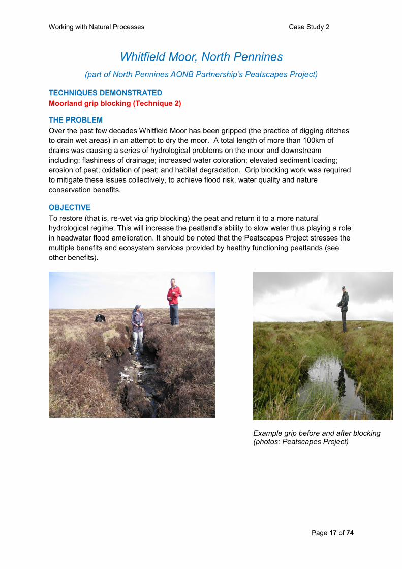
Example grip before and after blocking (photos: Peatscapes Project)

Working with Natural Processes Case Study 2
Page 18 of 74
PROJECT DESCRIPTION
Peatscapes is a collaborative project that aims to conserve and enhance the internationally
important peatland and upland resources within the North Pennines Area of Outstanding
Natural Beauty (AONB). Led by the North Pennines AONB Partnership Staff Unit,
Peatscapes aims to centralise, coordinate, streamline and celebrate the restoration,
conservation and monitoring efforts occurring on peatlands in the AONB. Peatscapes
undertakes restoration work on multiple sites within the 90,000 hectares of peatlands in the
North Pennines AONB. This case study focuses on Whitfield Moor, one of the 20 sites where
work has been completed over the past 3 years.
Grip blocking is a simple yet effective method of re-wetting peatlands. The technique is
supported and sanctioned by Natural England, the Environment Agency and the scientific
community. In an area where grips exist, a digger with low pressure tyres or tracks is
brought on site and dam material is dug out of an adjacent area and is placed in the grip
effectively blocking the ditch. This process is repeated in 7 to 12 metre intervals until a series
of peat dams block the length of the ditch. In a short period of time the water builds up
behind the plug and vegetation begins to grow forming a living dam. This has the effect of
retaining water behind each plug and re-wetting the peat by raising the surrounding water
table, allowing the peatland ecology to recover.
PROJECT SUCCESS AND LESSONS
Data collection and analysis for the first phase of the Peatscapes monitoring programme has
now been completed. The hydrological monitoring shows that blocked grips reduce the
amount of, and rate at which, water flows from the moorland. Early results suggest a
recovering peatland system and a significant change in hydrological regime from rapid
drainage to storage. The scientific community is stressing the need for long term monitoring
data (i.e. over 6 years) to quantify the benefits of blocking and rewetting and the associated
ecosystem services available from a grip-blocked peatland system. Peatscapes is continuing
to monitor two restoration sites up until 2012.
OTHER BENEFITS
Peatscapes stress the multiple benefits of peatland restoration including flood amelioration, carbon storage & sequestration, water colour reduction, sediment load reduction (erosion reduction), biodiversity improvement, and historic environment benefits.
ADDITIONAL INFORMATION
Project Location: Whitfield Moor (North Pennines)
Water Body: Upland tributaries of River South Tyne and River West Allen
Grid Reference: NY 73720 56631
Associated Partners: Environment Agency, Northumbria Regional Flood Defence
Committee, Natural England, Northumbrian Water Ltd, RSPB, English Heritage, Moorland
Association CEH, Northumberland Wildlife Trust, County Durham Environmental Trust
(CDENT), Esmee Fairburn Foundation, Waterloo Foundation, FWAG, Tyne Rivers Trust,
BGS.
Cost: £120k - this was the cost of blocking 120km or grips and restoring the hydrological
integrity of 480 hectares of peat at Whitfield Moor .
Further information: North Pennines AONB Website:
http://www.northpennines.org.uk/index.cfm?articleid=12218

Working with Natural Processes Case Study 7
Page 19 of 74
RSPB Beckingham Marshes, Nottinghamshire
TECHNIQUES DEMONSTRATED
Washland creation (Technique 11)
THE PROBLEM
Gainsborough and Beckingham have had a long history of fluvial flooding from the River
Trent which is tidal in this reach. Although the original washland scheme reduced flood risk,
like so many other schemes of the time, it also destroyed a large area of wetland habitat that
would have supported a broad range of wildlife.
OBJECTIVE
To reduce flood risk in Gainsborough and recreate 94 hectares of floodplain grazing marsh,
a UK Biodiversity Action Plan (BAP) priority habitat.
PROJECT DESCRIPTION
The original washland creation was undertaken in the 1960s when 1000 ha of agricultural
land was embanked to enhance flood storage. This facilitated the drainage of wet grassland
for arable farming within the washland. Flooding occurs over a fixed level inflow with
floodwater evacuated through a flapped outfall under a combination of gravity and pumped
drainage. The RSPB and Environment Agency are currently progressing a scheme to re-
create wet grassland habitat in the washland whilst maintaining the existing level of flood
defence. The engineering works will be implemented in 2010.
(Photo courtesy of RSPB)
Beckingham Marshes, showing area to be wetted (centre of picture) and River Trent (right)
Working with Natural Processes Case Study 7
Page 20 of 74
(Photo courtesy of RSPB)
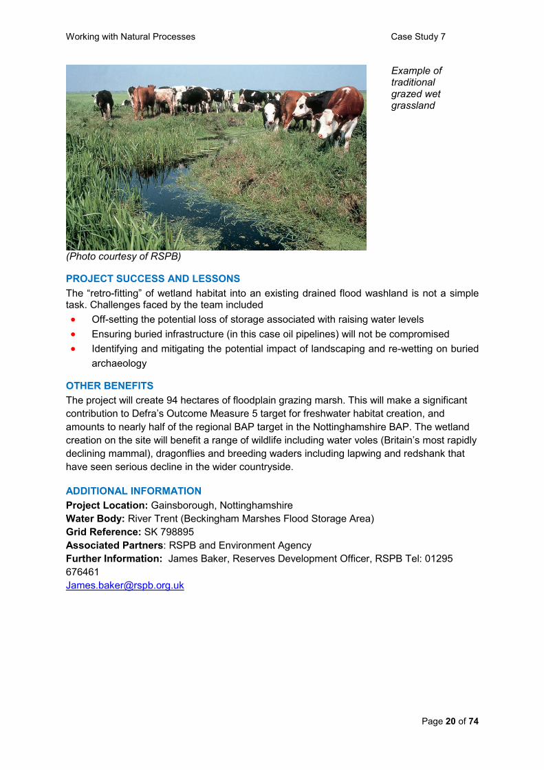
Example of traditional grazed wet grassland
PROJECT SUCCESS AND LESSONS
The “retro-fitting” of wetland habitat into an existing drained flood washland is not a simple task. Challenges faced by the team included
Off-setting the potential loss of storage associated with raising water levels
Ensuring buried infrastructure (in this case oil pipelines) will not be compromised
Identifying and mitigating the potential impact of landscaping and re-wetting on buried
archaeology
OTHER BENEFITS
The project will create 94 hectares of floodplain grazing marsh. This will make a significant
contribution to Defra‟s Outcome Measure 5 target for freshwater habitat creation, and
amounts to nearly half of the regional BAP target in the Nottinghamshire BAP. The wetland
creation on the site will benefit a range of wildlife including water voles (Britain‟s most rapidly
declining mammal), dragonflies and breeding waders including lapwing and redshank that
have seen serious decline in the wider countryside.
ADDITIONAL INFORMATION
Project Location: Gainsborough, Nottinghamshire
Water Body: River Trent (Beckingham Marshes Flood Storage Area)
Grid Reference: SK 798895
Associated Partners: RSPB and Environment Agency
Further Information: James Baker, Reserves Development Officer, RSPB Tel: 01295
676461

Working with Natural Processes Case Study 13
Page 21 of 74
Sinderland Brook, Altrincham, Cheshire
TECHNIQUES DEMONSTRATED
Re-meandering (Technique 16)
THE PROBLEM
Sinderland Brook near Broadheath, Altrincham, was channelised in the late 1960s by the
local water authority.
This resulted in increased flood risk during heavy rainfall events due to the brook‟s rapid
response to upstream runoff from Altrincham. In the late 1990s a proposal was put forward
by the landowner, National Trust, to create a flagship sustainable residential development,
which integrates with the surrounding environment. This included the proposal to restore the
brook and its floodplain to reduce the risk of flooding to a nearby housing estate and a newly
proposed housing development by Redrow Homes and Bryant Homes.
OBJECTIVE
One of the main objectives of the restoration work was to transform the existing canalised
watercourse to a diverse meandering river and extend its floodplain and thus reduce flood
risk to a nearby housing estate and a newly proposed housing development.
PROJECT DESCRIPTION
The project restored approximately 1.8km of the Sinderland Brook corridor from a heavily
canalised and toe-boarded watercourse into a diverse, natural and complex river system.
This involved re-meandering the brook and the excavation of a new wide floodplain which
provides significant flood protection benefits. The newly constructed brook is between 30-
50% narrower than the old canalised brook, and this encourages more frequent inundation
of the new floodplain, offering flood risk benefits to downstream areas.
No bank protection work was undertaken along the length of the restored reach, allowing the
river to freely adjust its planform and thus be sustainable in the long-term. Intervention will
only occur if erosion threatens the limits of the extended floodplain or serious instability is
identified.
PROJECT SUCCESS AND LESSONS
The construction of the new floodplain has provided an increase in floodplain storage area
that will cause a reduction in the flood pulse delivered to the downstream brook. A
hydrological monitoring programme is currently being undertaken by Haycock Associates.
The project has reduced the flood risk to a neighbouring housing development from a 1 in 35
year flood risk to 1 in 75 years, contributing to Defra‟s Making Space for Water programme.
The flood alleviation work will also provide a high level of protection for the new housing
development.
The project won a National Waterways Renaissance Award in 2008.

Working with Natural Processes Case Study 13
Page 22 of 74
Sinderland Brook during works
(photo courtesy of Environment Agency)
Sinderland Brook after the flood alleviation works, showing the meandering channel re-
connected to its floodplain
OTHER BENEFITS
The restoration of Sinderland Brook has created an attractive and enhanced environment
with diverse native habitats for wildlife. The restoration work has also provided significant
aesthetic and recreational benefits for the local public, and the next phase of the
development will involve the creation of footpaths and a community woodland. Following
comments from homeowners in the 1st phase of the development, who questioned why their
properties faced away from the brook, the subsequent phases of development look out onto
the watercourse.
ADDITIONAL INFORMATION
Project Location: Altrincham, Cheshire
Water Body: Sinderland Brook
Grid Reference: SJ 760 903
Associated Partners: National Trust (lead partner), Haycock Associates (river restoration
design and advisors to the National Trust), Bryant Homes, Redrow Homes
Cost: £3.9 million
Further information:
Haycock Associates: (http://www.haycock-associates.co.uk/home.html)
The River Restoration Centre: http://www.therrc.co.uk/newsletters/issue20.pdf
The Waterways Trust:
http://www.thewaterwaystrust.org.uk/newsfile/index.shtml?item=20080319.113914

Working with Natural Processes Case Study 22
Page 23 of 74
Cobbins Brook Flood Alleviation Scheme, Waltham Abbey SE England
TECHNIQUES DEMONSTRATED
Wetland creation (Technique 12)
On-line flood storage area (Technique 13)
THE PROBLEM
The town of Waltham Abbey has been subject to flooding on a number of occasions with
records stretching back as far as 1947. The most recent flooding in October 2000 affected
97 mainly residential properties and a school and caused an estimated £2.3m in financial
damages. This flood event was assessed as having a return period of between 1:20 and
1:30 years.
OBJECTIVE
At that time of the 2000 flood, the level of service of 1:5 years was significantly below that
recommended by Defra of 1:50 to 1:200 years for a dense urban area. The only formal
existing flood defence was a concrete lined channel in the centre of the town which was
constructed in the late 1970s. The objective of the Cobbins Brook Flood Alleviation Scheme
is to reduce flood risk to Waltham Abbey.
Although the Cobbins Brook catchment upstream of Waltham Abbey is relatively small
(approximately 26 km2), the catchment is quite steep and is urbanised at the top end, where
it also receives drainage from the M25 motorway. Consequently, flow in the river is quite
flashy, and appraisal of options to improve flood risk management identified that flood
storage upstream of Waltham Abbey would provide the most cost-effective solution.
(photomontage of predicted wetland development, courtesy Halcrow Group Ltd )
By lowering the ground level within the main flood storage area, pasture is converted to a mosaic of wetland and wet grassland

Working with Natural Processes Case Study 22
Page 24 of 74
PROJECT DESCRIPTION
A clay embankment approximately 490m long and 5m at its highest point has been
constructed across the floodplain to connect to areas of naturally higher ground on either
side. There is also some additional minor raising of a low point in the local topography. Out
of bank flow is retained in a rural area without threat to flooding of any properties. Ground
levels in the flood storage area have been lowered, and the river bank also lowered locally to
provide a high-flow connection between the river and the flood storage area. The combined
result locally is an increased frequency and duration of wetting of the floodplain, and the
creation of a flood storage area with a capacity of 758,000 m3. This reduces the risk of
flooding to more than 300 properties in Waltham Abbey and to the M25 motorway.
The project involved construction of a short culvert and associated adjustable structure to
“throttle” the river and encourage flow into the flood storage area. To minimise the
hydrological and geomorphological effects of this culvert, the site was carefully selected to
allow the culvert to replace an existing weir. Overall, the longitudinal profile of the river was
restored to a more natural state.
PROJECT SUCCESS AND LESSONS
The flood storage area has been designed to maximise the available volume at its location
and as such is able to store a flood of the size of a 1:200 year event before the spillway
starts to come into action at this level. However, due to inflows downstream of the storage
area, the level of service within Waltham Abbey is 1:50 years.
The design closely integrated engineering with landscape and environment. In particular,
mitigation measures to minimise the effect of the new embankment and culvert have
included: a textured bed to encourage invertebrate and fish movement through the culvert;
scrub planting over the embankment to maintain a continuous line of riparian vegetation for
bats, birds and other wildlife; and establishment of florally diverse grassland on the
embankment.
OTHER BENEFITS
By sourcing the construction materials from the flood storage area itself, new landforms have
been created. Approximately 4 hectares of previously arable and pasture land has been
converted to a wetland complex, primarily pools and wet grassland but also with an area of
wet woodland.
Additional river restoration measures have been incorporated, including introduction of 3
berms and riffles into an historically straightened reach, and a short reach of channel
narrowing and bed raising to bury historic hard engineering.
ADDITIONAL INFORMATION
Project Location: In farmland approximately 2km north east of Waltham Abbey, Essex
Water Body: Cobbins Brook (tributary of River Lee)
Grid Reference: TL413 021
Associated Partners: Environment Agency, Epping Forest District Council, Halcrow,
Jackson Civil Engineering
Cost: £6 million
Further Information: Environment Agency, Thames Region - North East Area and National
Capital Programme Management Service

Working with Natural Processes Case Study 32
Page 25 of 74
Hesketh Out Marsh West, Ribble Estuary, NW England
TECHNIQUES DEMONSTRATED
Managed realignment (Technique 17)
THE PROBLEM
Hesketh Out Marsh is located on the south bank of the Ribble Estuary, which has an
extensive history of reclamation. The shoreline was effectively fixed as a result of training
walls and flood embankments to protect agricultural land (arable crops and market
gardening). The site offered the potential for managed realignment to create intertidal
mudflat and saltmarsh landward of the current privately-owned embankment, whilst an
existing Environment Agency embankment further landwards needed repair to maintain the
level of coastal flood protection to the communities of Hesketh Bank.
Part of the Ribble Estuary SSSI lies within the site and the site is bordered by a Special
Protection Area (SPA), Ramsar Nature Reserve, and a Site of Special Scientific Interest
(SSSI).
OBJECTIVE
The RSPB and the Environment Agency scheme aims to create additional intertidal habitat
at the same time as improving flood defence standards. The main objectives were to create
intertidal habitat that:
Can be utilised by a wide range of wintering and breeding waterfowl;
Includes saltmarsh, muddy creeks and saline lagoons;
Has unhindered tidal exchange, requires minimal management and has the capacity
to respond to dynamic estuarine change; and
Enhances Biodiversity Action Plan habitats and species.
In terms of flood risk management, the scheme aims to increase the standard of flood
protection to communities of Hesketh Bank, by repairing and strengthening the primary sea
defence. All embankments within the scheme will have levels which exceed the 1 in 200
year still water level (but do not offer protection of 1 in 200 year standard).
Sea defences breached in September 2008, letting the tidal waters of the Ribble Estuary wash over farmland on reclaimed saltmarsh. (Photo: Halcrow Group Ltd)

Working with Natural Processes Case Study 32
Page 26 of 74
PROJECT DESCRIPTION
The main elements of the scheme are:
Improvement of an Environment Agency owned earth embankment running along the
south of the site, and construction of a new earth embankment to separate it from
Hesketh Out Marsh East;
Excavation of creeks and lagoons within the site;
Creation of four breaches in the outer embankment to allow tidal inundation of the
site. These breaches will remove 100m wide sections of the existing defences down
to the level of the existing marsh and create 25-40m wide channels to connect the
creeks inside the site with those on the fronting marsh;
Installation of an outfall structure containing tidal valves at the point where an existing
watercourse flows into the site.
Geographical Information System (GIS) was successfully used to support recreation of a
creek system, by identify the position and width of former creeks from old aerial
photographs, and the depths of comparable creeks on the marsh in front of the site (to
ensure linkage with the new creeks). GIS was also used to create a digital elevation model
of the scheme and support a detailed mass balance calculation to ensure the new
embankments could be constructed from material extracted from the creeks, lagoons and
breaches.
A hydrodynamic model was used to investigate scenarios for realignment, including the
conditions (e.g. gradients and elevations) suitable for development of functional intertidal
habitats and the appropriate sizes and designs of the breaches. An ecotoxicological risk
assessment was undertaken to ensure that contaminated land discovered during the
scheme‟s design would not release levels of contamination that could harm aquatic life or
birds using the area.
PROJECT SUCCESS AND LESSONS
The scheme has provided compensatory saltmarsh habitat allowing Lancaster City Council
to progress its Morecambe Coastal Works Phases 6 and 7.
At 168 hectares, the scheme is one of largest managed realignments in the UK to date.
OTHER BENEFITS
Partnership between the RSPB (as owners of the site) and Environment Agency allowed for
local sourcing of the materials required for embankment repair works, reducing the overall
cost and environmental impact of this element of the scheme.
The RSPB will manage the site as a breeding ground for wading birds such as lapwings,
redshanks, avocet and oystercatcher and as a vital winter refuge for species like pink-footed
geese, whooper swans, wigeons, teals and golden plovers. The additional contribution to
the local economy from tourism in the area (currently believed to be more that 100,000
visitors per year) is likely to continue for the foreseeable future.
ADDITIONAL INFORMATION Project Location: Ribble estuary, Lancashire Grid reference: SD 3415 4253 Associated Partners: RSPB, Environment Agency, Lancaster City Council, Halcrow Cost: £4 million Further information: RSPB web site (www.rspb.org.uk)

Working with Natural Processes Case Study 33
Page 27 of 74
River Quaggy, Sutcliffe Park, SE London
TECHNIQUES DEMONSTRATED
Floodplain reconnection (Technique 9)
Riffle creation (Technique 10)
Wetland creation (Technique 12)
On–line flood storage area (Technique 13)
Two-stage channels (Technique 15)
Re-meandering (Technique 16)
THE PROBLEM
When the National Rivers Authority (NRA) - now the Environment Agency - first proposed a
new flood alleviation scheme for the River Quaggy in 1990 they planned to use the
technique of canalising the river. However, the Quaggy Waterways Action Group (QWAG)
were able to show that a large part of the river‟s flooding problems were due to previous
canalisation, which was conveying large amounts of water downstream, causing flooding
problems in Greenwich and Lewisham.
OBJECTIVE
To reduce the risk of flooding from the River Quaggy to some 600 properties and 4000
people living and working in the London Boroughs of Greenwich and Lewisham.
(photo courtesy of Halcrow Group Ltd)
A new „low-flow‟ meandering channel was cut through the park following its original (pre culverted) alignment. The previous canalised culvert running along the perimeter of the park was retained. This now carries excess water as flow volumes increases in the low flow channel. Flow is regulated between the low flow channel and the culvert by a flume. The flat underused park was converted into a flood storage area, lowered and re-shaped and is now capable of storing up to 85,000m3 of flood water. Excess water is diverted from the storage area back into the culvert via a spillway.

Working with Natural Processes Case Study 33
Page 28 of 74
PROJECT DESCRIPTION
Prior to the works, The River Quaggy was a channelised river, and Sutcliffe Park was a flat
underused park. The flood alleviation works involved realigning and re-meandering the river
Quaggy through Sutcliffe Park which was converted into a large (85,000m3) flood storage
area (FSA), which also incorporated wetland creation. The old underground concrete culvert
has been retained and now accommodates excess water as flow volumes increase. The flow
of the river is now regulated - In dry conditions the greater proportion (around 50 litres per
second) is directed into the realigned „low flow‟ meandering open channel. As the volume of
water increases more gets diverted into the culvert. In flood conditions, two cubic metres a
second could flow down the river while 18 cubic metres a second enters the culvert. A
crucial feature of the project design is a flume (a constriction) which is built into the culvert
along its northern (downstream) limb. This serves to limit the amount of water that can pass
into the culvert. When the limit is reached flood water backs up to a level where it begins to
flow out into the park through a high-flow inlet, which slowly fills from its northern end. The
FSA takes 12 hours to reach its capacity of 85,000 cubic metres. If this capacity is exceeded
any excess water is safely directed back into the culvert via a spillway immediately
downstream of the flume. After a flood the water could take 12 hours to drain away through a
'low-flow outlet'. The flow of water throughout is largely controlled by the careful shaping of
the park, thus avoiding the need for mechanical controls.
PROJECT SUCCESS AND LESSONS
The work was completed in 2004. The combination of the new smaller open river together
with the old culverts is a good demonstration of how to regulate flows to help reduce future
flood risk. Sutcliffe Park has become a blueprint for „best practice‟ in providing a
multifunctional solution to flood risk.
OTHER BENEFITS
Sutcliffe Park now comprises a diverse range of wildlife habitats including open watercourse,
wetland pond areas, wildflower meadows, reed beds and a variety of native trees. The park
is universally recognised by conservation groups such as National Trust, British Trust for
Ornithology and members of Kingston University who have all commented on the surprising
degree of biodiversity. A network of boardwalks, pathways and viewing points has helped to
attract visitors to the park.
ADDITIONAL INFORMATION
Project Location: Eltham, South East London
Water Body: River Quaggy (tributary of River Ravensbourne)
Grid reference: TQ411748
Associated Partners: Environment Agency, Quaggy Waterways Action Group, Breheny
Engineering, Greenwich Council
Further information: Quaggy Waterways Action Group Website:
http://www.qwag.org.uk/quaggy/flood.php
CABE http://www.cabe.org.uk/case-studies/quaggy-river
Working with Natural Processes Case Study 38
Page 29 of 74
Dark Water, Hampshire - Tidal Flap Replacement
TECHNIQUES DEMONSTRATED
Regulated Tidal Exchange (Technique 18)
THE PROBLEM
The Dark Water is located to the south of Fawley, Hampshire. The site has been
progressively reclaimed from the sea by construction of an embankment along its seaward
end and installation of a tidal flap on the outfall at Lepe beach to limit tidal inundation of the
site. The Dark Water site was targeted as a possible site for intertidal habitat re-
establishment to offset losses by coastal squeeze elsewhere within the Solent. In addition,
the tidal flap had degraded and also presented logistical difficulties related to routine
maintenance, such that a replacement structure was desirable for operational reasons.
OBJECTIVE
A number of holes in the tidal flap were allowing saline intrusion upstream of the structure
creating a saline brackish (saltmarsh) environment. The objective was to replace the tidal
flap with a new structure which incorporated apertures to maintain and increase the
favourable regulated tidal exchange which had been occurring, and provide additional tidal
water storage, without compromising the primary tidal defence function of the structure.
The advantages of the new flap are that:
There will be flexibility in the design to increase / decrease saline intrusion for the
future
It will have a longer life and be easier to maintain than the previous flap
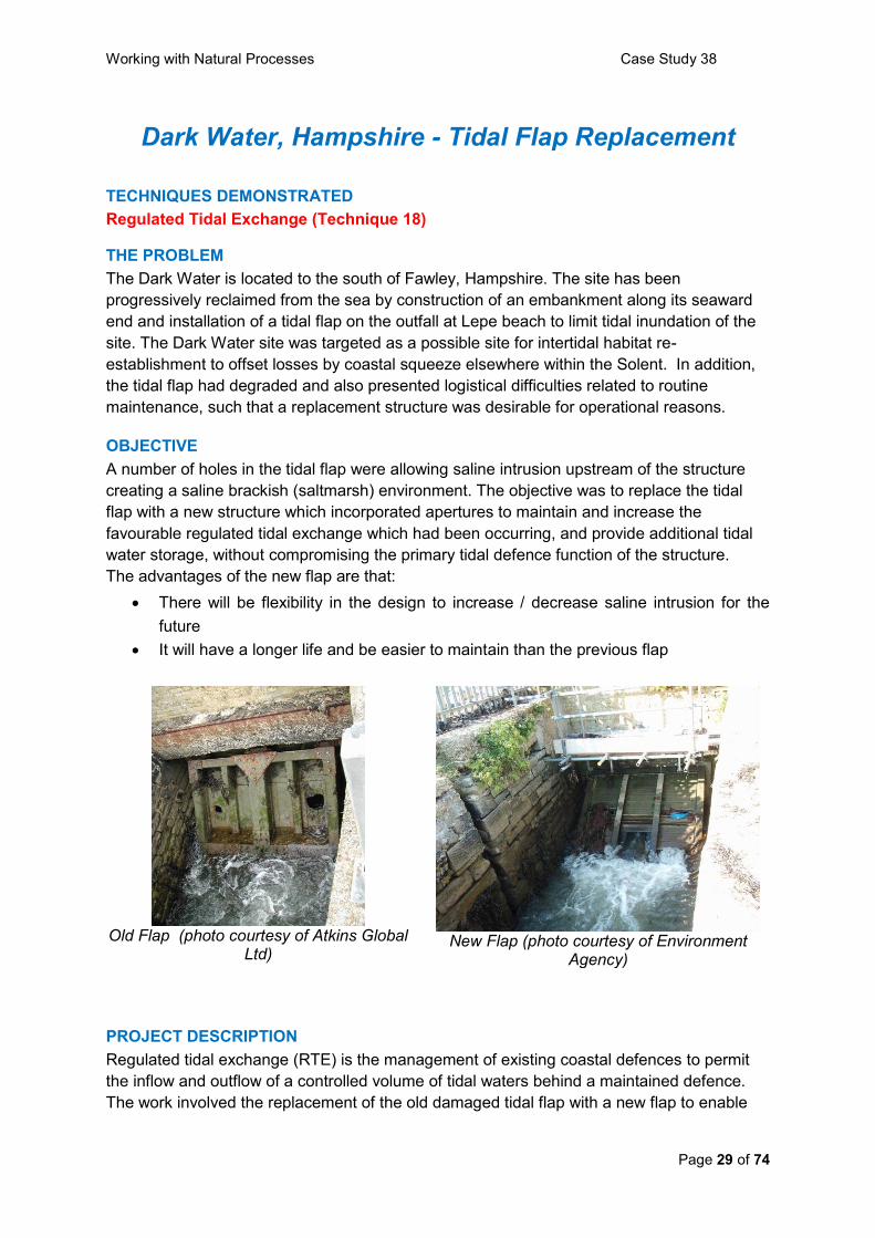
Old Flap (photo courtesy of Atkins Global
Ltd)
New Flap (photo courtesy of Environment
Agency)
PROJECT DESCRIPTION
Regulated tidal exchange (RTE) is the management of existing coastal defences to permit
the inflow and outflow of a controlled volume of tidal waters behind a maintained defence.
The work involved the replacement of the old damaged tidal flap with a new flap to enable

Working with Natural Processes Case Study 38
Page 30 of 74
the quantity of saline ingress at high tides to be adjusted so as to maintain and extend the
salt marsh that had developed in the river valley. The design has the potential to increase
the volume of saline ingress in the future if the need arises.
PROJECT SUCCESS AND LESSONS
The predicted development of intertidal and other habitats is summarised in the table; the project was implemented in 2007 and thus far habitat evolution has been occurring in accordance with the plan.
Habitat Type Area (ha) %
Predicted mudflat 12.6 17
Predicted saltmarsh 21.7 29
Predicted grazing marsh 20.0 3
Existing habitat unaffected 37.7 51
Extent of tidal inundation (blue) before (left) and after (right) regulated tidal exchange
Saltmarsh habitat developing on the left bank of the river (photos courtesy of
Halcrow Group Ltd) After installation, an abnormally high tide caused flotation of the flap and removed it from the
housing. Minor modifications were made to the design, incorporating chains to prevent the
same happening again.
ADDITIONAL INFORMATION
Project Location: Lepe beach, south of Fawley, Hampshire
Water Bodies: Dark Water, Solent
Grid Reference: SZ 45264, 98520
Associated Partners: Natural England, Environment Agency, W.S.Atkins
Cost: £120k
Further Information: Environment Agency, Southern Region, Solent and South Downs
Area office. Tel. 08708 506 506

Working with Natural Processes Case Study 42
Page 31 of 74
Newbiggin Bay Beach Recharge, Northumberland
TECHNIQUES DEMONSTRATED
Manage natural coastal defence features (Technique 21)
THE PROBLEM
Over the last 20 years or so a large amount of sand has been lost from the beach at
Newbiggin as a result of tidal erosion. Mining subsidence has also lowered the beach. This
depletion had left the frontage at Newbiggin vulnerable to storm wave attack and
consequential flooding.
OBJECTIVE
To recharge the beach with around 500,000 tonnes of sand, brought by dredger from the
Lincolnshire coast, to provide additional sea defence.
PROJECT DESCRIPTION
Between March and October 2007, the Northumbrian coastal village of Newbiggin by the
Sea underwent a major project to bring the once famous beach and sea front back to and
beyond its former glory. The £10 million project included building a new breakwater and
recharging the beach with 500,000 tonnes of new sand. Each load of 15,000 tonnes was
pumped ashore via a sunken 1.4km pipeline, connected at one end to a flexible riser pipe
and float. The sand was directed to the desired locations on the beach and then spread by
earthmoving equipment to create the beachscape. The process was repeated about 30
times, each one taking approximately one day.
500,000 tonnes of new sand was pumped onto the existing beach. This was then spread and levelled to profile by bulldozers. (Photos: Newbigginbay.co.uk website)
The new sand provides a natural sea defence, which helps to protect and increase the effectiveness of the exiting concrete sea defences.
Working with Natural Processes Case Study 42
Page 32 of 74
PROJECT SUCCESS AND LESSONS
A scale-model of the bay with the breakwater and sand was built and tested with a simulated
wave climate. This showed the design worked as expected but it required an increase to the
weight of the rock core for the breakwater from 5 tonnes to 9 tonnes for storm events. After
two years, sand data has shown that there has been no loss of material offshore of the
breakwater.
The Newbiggin Bay coastal protection scheme, which was designed and project managed
by Atkins, was awarded the civil engineering project category at the British Construction
Industry Awards.
OTHER BENEFITS
The renourishment work will provide a much larger area of sand at low tide for the
community and visitors to enjoy.
ADDITIONAL INFORMATION
Project Location: Newbiggin by the Sea, Northumbria
Water Body: North Sea
Grid Reference: NZ 312 875
Associated Partners: Wansbeck District Council, Atkins, Westminster Dredging
Cost: £10 million (for entire Newbiggin Coast Protection Scheme, of which beach
replenishment was a part)
Further Information: Imogen Parker, Atkins, Tel +44(0)1372 756905, Email:
Newbiggin Bay Replenishment Project 2007 website - http://www.newbigginbay.co.uk/

Working with Natural Processes Case Study 55
Page 33 of 74
Conwy Valley FAS, North Wales
TECHNIQUES DEMONSTRATED
Floodplain reconnection (Technique 9) THE PROBLEM The village of Llanrwst in the Conwy valley has suffered from significant flooding from the
Afon Conwy over the last decade, notably in 2004 and 2005. A historic Bridge (Pont Fawr)
holds back flows which are further constricted downstream by extensive flood banks which
predominantly protect agricultural land. These bank are very old and in places in poor
condition.
When the water backs up at the Pont Fawr the water initially spills out on the left bank onto
playing fields. However, the flood water‟s progress across the floodplain is halted by an
embankment known as White Barn (south). In a large flood as experienced in 2004 and
2005, the water is held back by White Barn (south) and backs up until the right bank spills
out into the historic centre of Llanrwst. Also, the White Barn (south) embankment failed in
one place and flood water crossed the floodplain and flooded part of a small settlement
(Trefriw,) which lowered flood levels in Llanrwst.
OBJECTIVE
To better protect Llanrwst from flooding, and to reduce the flood risk to Trefriw.
PROJECT DESCRIPTION
By lowering the White Barn (south) embankment flood water will overtop the structure in a
controlled manner at a level which will help reduce flood levels in Llanrwst. Some defences
will still be need in Llanrwst but these can be lower than would otherwise be the case and
the design will enable more use of demountable structures. Trefriw would be offered
protection by a new flood bank. By lowering White Barn (south) this will allow the
reconnection and utilisation of the floodplain. Current modelling shows that the flood bank
once lowered will overtop around five times per year. The works completion is expected in
late 2009.

Working with Natural Processes Case Study 55
Page 34 of 74
PROJECT SUCCESS AND LESSONS
The scheme is due for completion in late 2009.
OTHER BENEFITS
Wetland creation by excavating borrow pits for material for the embankment around Trefriw.
ADDITIONAL INFORMATION
Project Location: Llanrwst / Trefriw, North Wales
Water Body: Afon Conwy
Grid Reference: SH 785 635
Associated Partners: Environment Agency, Halcrow, May Gurney
Cost: £5.7m
White Barn (south) embankment showing breach failure created during flooding.
White Barn (south) embankment prior to lowering. The Afon Conwy is to the left of the embankment which currently protects the farmland to the right from flooding. Post scheme this farmland will be expected to flood approximately five times a year

Working with Natural Processes Case Study 56
Page 35 of 74
River Erewash, Derbyshire
TECHNIQUES DEMONSTRATED
Creation or re-instatement of a ditch network to promote infiltration (Technique
7)
Off-line flood storage area (Technique 14)
Two-stage channels (Technique 15)
Re-meandering (Technique 16)
THE PROBLEM
Historically, the River Erewash had been straightened and a number of meanders had been cut off from the channel and had silted up and been invaded by scrub to varying degrees. However, the wider floodplain had not been developed for housing or other urban use, so these features were still in existence. When works were needed to raise existing flood embankments, the opportunity was taken to combine local acquisition of material for the embankment with floodplain habitat improvements.
OBJECTIVE
The project was to support the wider flood risk management scheme to raise existing floodbanks by sourcing material locally. The required flood defence standard was to be maintained whilst implementing improvements to river channel and floodplain habitat diversity (improving their conservation, fishery and recreational value).
PROJECT DESCRIPTION
The project is located on the River Erewash to the west of Nottingham and a few kilometres upstream of its confluence with the River Trent. Two new floodplain ponds were excavated, providing material for raising the local flood embankment. The major part of the habitat improvement works entailed reconnection of two severed meanders to the existing straightened channel. Each was connected at both ends to allow flow through. The existing channel was retained, with flow diverted into the reconnected meander by means of a sloping riffle weir. An additional small new watercourse was constructed off one of the meanders to convey “top up” water to the two new ponds. Additional floodplain habitat diversity was achieved by creating shallow scrapes in remnant low spots. Spoil from the meander and scrape excavation was used to form a new floodplain “island”; thus the impact on floodplain storage was neutral. The length of rehabilitated floodplain was 700m. In addition, subsequent work entailed rehabilitating ancient floodplain ponds which had been cut off from the river and were drying up, silted or overgrown.
Plan showing new ponds, remnant meanders to reconnect, and new scrapes

Working with Natural Processes Case Study 56
Page 36 of 74
(© Environment Agency)
New pond formed from borrow pit, with “top up” channel in foreground
Reconnected (previously dry) meander
PROJECT SUCCESS AND LESSONS
A diverse range of floodplain channel and wetland features was successfully created. The
reconnected meanders were rapidly colonised by a range of emergent plant species,
kingfisher and water vole, whilst the new ponds were quickly colonised by breeding
populations of smooth newt, common frog and common toad.
The presence in the existing river channel of water voles was confirmed by survey before the
works commenced, and meant that proposals to reprofile the banks of the existing channel
were not implemented.
Siltation of the new channels resulted in reduced dry weather flow, although this siltation is
scoured by peak winter flows.
Invasive non-native plant species (parrot‟s feather, curly waterweed and Australian swamp
stonecrop) were identified in the new floodplain ponds within the first year after construction.
Similar projects would benefit from assessment of potential sources of such alien species,
and management implications should they colonise.
OTHER BENEFITS
The new and rehabilitated floodplain habitat features are closer than the river to a parallel
footpath and cycleway, providing an improved visual and recreational (bird watching)
environment for users of the path.
ADDITIONAL INFORMATION
Project Location: Between Sandiacre and Long Eaton, on the south-western fringe of
Nottingham
Water Body: River Erewash
Grid Reference: SK 485 350
Associated Partners: Environment Agency
Cost: £35k (meander construction cost only)
Link to Further Information: Environment Agency, Midlands Region, Conservation team

Working with Natural Processes Case Study 57
Page 37 of 74
Great Eau and Long Eau, Lincolnshire
TECHNIQUES DEMONSTRATED
Floodplain reconnection (Technique 9)
Riffle creation (Technique 10)
Washlands (Technique 11)
THE PROBLEM
Historically, the low-lying Long Eau and Great Eau have been heavily modified by the
construction of floodbanks to increase the capacity of the river channel and temporarily store
more fresh water when “tide-locked” at high tide. Over time this led to silting of the river bed,
(and loss of some of the additional storage capacity) and attendant ecological degradation
due to loss of natural river processes and habitats. Dredging was necessary to maintain
flood storage capacity.
OBJECTIVE
The available in-channel storage came to be seen as a far less sustainable option than the
use of the floodplain. By removing the floodbank along one side of the river at each site, and
replacing it with a new set-back embankment, the historic floodplain could be reconnected,
resulting in a more sustainable storage based flood defence system (425,000 m3) and
improving wildlife value.
PROJECT DESCRIPTION
The floodplain was reconnected to the river by removing one floodbank at each of 3 sites –
Withern, Manby and Little Carlton. New storage was established by constructing new
embankments set back from the river by up to 500m, or utilising the natural rise in land to
maintain the level of flood protection. The footprints of the removed floodbanks were
allowed to develop as wetland marginal habitat. Wetland habitats were also established on
the floodplain, including lowering of ground levels to create a new reedbed and enlargement
of a remnant floodplain pool, both at Withern. River channel improvements at Manby
included creation of wet ledges (berms) along the channel to encourage marginal wetland
development, creation of 20 riffles using imported flint, chalk and gravel, and creating cliffs
for kingfishers on the outside of bends where floodbanks were retained.
Long Eau at Manby before floodbank removal and in flood conditions after removal
(© Environment Agency)

Working with Natural Processes Case Study 57
Page 38 of 74
PROJECT SUCCESS AND LESSONS
Hydrological modelling indicated an increase in the standard of flood protection over a 3km
stretch of the Long Eau at Great Carlton and Manby, from 1 in 20 year to a 1 in 50 year
standard. Early consultation with Internal Drainage Boards was key to the success, as was
landowner support. Negotiations with landowners to demonstrate the benefits of
Environmental Stewardship were made more effective by involving the administering body
(currently Natural England).
A study of the scheme at Manby in 2007, as part of a wider project, showed that the success
of the riffles in terms of increasing habitat diversity was limited by the exceptionally flat
gradient of the river. The riffles act to pond the flow and fine sediment has settled out above
the features. Assessment of the available gradient must be an important element of installing
and locating riffles.
(© Environment Agency)
OTHER BENEFITS
Prior to the works, the defended land was given over to intensive arable farming. Monitoring
since completion of the work has included hydrological, habitat, botanical, bird, fishery and
invertebrate surveys. Improvements were seen rapidly, with increased plant diversity within
the river channel and on the floodplain, a range of aquatic species colonising riffles, and
increased numbers of waders and wildfowl all seen within the first few seasons.
Working with Natural Processes Case Study 57
Page 39 of 74
ADDITIONAL INFORMATION Project Location: Manby and Withern areas of Lincolnshire
Water Body: Great Eau, Long Eau
Grid Reference: TF 434 825 and TF 396 865
Associated Partners: Environment Agency, Countryside Commission (now part of Natural
England), Farming and Wildlife Advisory group
Further information: Environment Agency, Anglian Region

Working with Natural Processes Case Study 59
Page 40 of 74
Fordingbridge Flood Defence Scheme, Hampshire
TECHNIQUES DEMONSTRATED
Washlands (Technique 11)
Wetland creation (Technique 12)
Off-line flood storage area (Technique 14)
THE PROBLEM
During October 2000 and the winter of 2001/2002 much of the Hampshire Avon valley
suffered heavy flooding causing much damage and distress to the local residents. In
response to these events the Environment Agency commissioned feasibility and design
studies for three discrete flood defence projects located at Downton, Fordingbridge and
Ringwood. Fordingbridge had a history of flooding with nine significant events occurring
since 1960. That of December 2000 was a major event affecting 76 properties. Flooding in
Fordingbridge is as complex problem involving interactions between fluvial surface water,
groundwater and highway drainage/sewage, which required an integrated solution.
OBJECTIVE
Solutions for alleviating flooding at Fordingbridge were appraised against a number of
engineering, economic, environmental and sustainability objectives. The overriding
engineering objective of the Fordingbridge Flood Defence Scheme was to provide fluvial
flood alleviation for properties, businesses and highways.
Bypass channel to divert high flows from the Ashford Water into the adjacent FSA (to left of photo) General scheme layout (Photo and drawing courtesy of Halcrow Group Ltd)
MEADOWS to flood from bypass channel & River
Avon during high flows

Working with Natural Processes Case Study 59
Page 41 of 74
PROJECT DESCRIPTION
Fordingbridge Flood Defence Scheme combined flood banks/walls, river works and
enhanced drainage systems to provide a 1 in 100 year standard of fluvial flood defence. A
suite of potential solutions was established through consultation with statutory consultees
and landowners during the scheme‟s design. Alternatives included flood walls/banks in the
town, creation of two-stage channels on the River Avon, off line flood storage areas and
washlands. The final 1:100 year scheme includes the diversion of 7m3/s floodwater onto the
floodplain southwest of Fordingbridge away from the historical town centre, minimising the
amount of hard defences and landowners directly affected and enhancing large areas of
wetland habitat. The scheme protects approximately 300 properties and the town centre. It
required a multi-authority collaboration to deliver such an integrated approach to flood risk
management and maximise the flood defence benefits, including involving the Environment
Agency, New Forest District Council, Hampshire County Council and Wessex Water.
PROJECT SUCCESS AND LESSONS
The environmental aspects heavily influenced the design of the flood defence scheme in a
highly sensitive environment, resulting in a more sustainable approach to the management
of flood risk and significant enhancement opportunities. Particular care was taken to protect
the environment during the construction phase and to deliver the scheme‟s many
environmental enhancements. Sufficient budget allowed detailed modelling of flood risks
around the FSA to give land owners confidence in the scheme.
Changes in local hydrology (in particular flow speeds) associated with the new by-pass
channel have resulted in local accretion of gravels at the channel‟s entrance. This is likely to
require periodic dredging to ensure the desired flow split is maintained in the long term.
Construction was completed in July 2006, under budget and ahead of programme.
OTHER BENEFITS
The bypass channel resulted in the creation of 3km of ditch habitat and enhancement of 30
ha of floodplain grazing marsh (a UK BAP priority habitat) by delivering more regular shallow
flooding to benefit wetland flora and fauna such as otters, breading waders, wildfowl and
Desmoulin‟s whorl snail. This will support the integrity of the adjacent SAC/SPA and the
area‟s eligibility for agri-environment schemes. Also, the washlands are recognised in the
Local Plan to protect their future function and positively influence future development control.
Other enhancements include improved fish passage at Town Mill Sluice and a new footpath
for the local community. The bypass channel‟s neutral cut-fill balance reduced the need for
transportation of material.
In recognition of these successes, the scheme was awarded the Environment Agency‟s
NCPMS national Project Excellence Award for „Environment & Sustainability‟ and „Overall
Winner‟ in 2006.
ADDITIONAL INFORMATION
Project Location: Fordingbridge, Hampshire Water Body: Ashford Water, River Avon Grid reference: SU147146 Associated Partners: Environment Agency, Halcrow Group Ltd, Team Van Ord, EC Harris Cost: Total scheme cost was £5.3M. A 10% saving and delivery ahead of programme was achieved. Further Information: Phil Barlow, Environment Agency, Manley House, Kestrel Way, Exeter, Devon, EX2 7LQ 08708 506506

Working with Natural Processes Case Study 73
Page 42 of 74
Lincshore, 2005 – 2009 Beach Re-nourishment
TECHNIQUES DEMONSTRATED
Removal of coastal structures impeding long shore drift (Technique 20)
Manage natural coastal defence features (Technique 21)
THE PROBLEM
The Mablethorpe to Skegness coastal frontage has a long history of beach erosion, with
flooding events recorded as far back as the 13th Century. In more recent times, there was a
major breach of the defences on the night of 31 January 1953, when a surge tide broke
through the defences in numerous places, resulting in the death of 41 people. The defences
were rebuilt in the aftermath and have required maintenance, repair and upgrading ever
since. A major issue is caused by the erosion of the sand beach which results in the
exposure and undermining of the rebuilt hard defences.
OBJECTIVE
To re-nourish the beach in front of the existing hard defences to protect them against failure,
thereby affording protection to 35,000 hectares of land, including 21,500 properties, mainly
in the areas of Mablethorpe and Skegness.
Sand dredged from a licensed site in the North Sea is pumped onto the beaches via a 400m long submerged pipeline from the dredger. (photos courtesy of Environment Agency)
The sand is then spread and levelled to profile by a dozer. This re-nourishment process has proved effective in maintaining a healthy beach along the Mablethorpe to Skegness frontage.

Working with Natural Processes Case Study 73
Page 43 of 74
PROJECT DESCRIPTION
A coastal management strategy was developed which concluded that re-nourishment of the
beaches, along with subsequent annual re-nourishment to replace losses, represented the
best technical, environmental and economic solution to secure these defences.
The Lincshore beach nourishment project has taken place between Mablethorpe and
Skegness under a number of campaigns since 1994, using sand dredged from the North
Sea to replace sand lost from the beach through natural erosive processes. The sand is
dredged from a licensed site approximately 25 miles offshore using a dredger which sucks
specifically graded material from the sea bed into the hopper of the dredger. The dredger
then sails back to the shore, as close as the water depth allows, before pumping the sand
onto the beaches via a submerged pipeline, typically 400m long. The sand is then spread
and levelled to profile by a dozer.
An additional part of the project is the removal of old timber groynes along the Mablethorpe
to Skegness frontage which were proving ineffective in maintaining beach levels. Their
removal permits the beach to revert to a more natural plan shape and profile.
PROJECT SUCCESS AND LESSONS
The re-nourishment process has proved effective in maintaining a healthy beach along the
frontage. In turn, the beach provides protection to the sea defences, thereby helping to
protect people and property from the risk of flooding. Re-nourishment will be necessary
annually to replace sand lost through erosion.
OTHER BENEFITS
The beach re-nourishment maintains good beaches for recreation. Tourism is an important
element of the local economy for Mablethorpe and Skegness.
ADDITIONAL INFORMATION
Project Location: Mablethorpe to Skegness, Lincolnshire.
Water Body: North Sea
Grid Reference: TF 510 849 to TF 572 650
Associated Partners: Environment Agency, Lincshore Re-nourishment Group (a joint
venture between Van Oord UK Ltd and Westminster Dredging), Defra, Halcrow Group Ltd.
Cost: £38M over five years approved programme (2005 – 2009 campaign)
Further Information: Environment Agency, Anglian Region
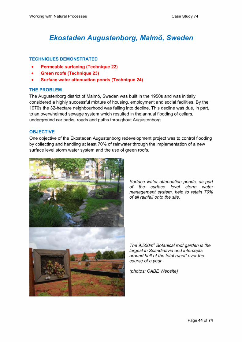
Working with Natural Processes Case Study 74
Page 44 of 74
Ekostaden Augustenborg, Malmö, Sweden
TECHNIQUES DEMONSTRATED
Permeable surfacing (Technique 22)
Green roofs (Technique 23)
Surface water attenuation ponds (Technique 24)
THE PROBLEM
The Augustenborg district of Malmö, Sweden was built in the 1950s and was initially
considered a highly successful mixture of housing, employment and social facilities. By the
1970s the 32-hectare neighbourhood was falling into decline. This decline was due, in part,
to an overwhelmed sewage system which resulted in the annual flooding of cellars,
underground car parks, roads and paths throughout Augustenborg.
OBJECTIVE
One objective of the Ekostaden Augustenborg redevelopment project was to control flooding
by collecting and handling at least 70% of rainwater through the implementation of a new
surface level storm water system and the use of green roofs.
Surface water attenuation ponds, as part of the surface level storm water management system, help to retain 70% of all rainfall onto the site.
The 9,500m2 Botanical roof garden is the largest in Scandinavia and intercepts around half of the total runoff over the course of a year (photos: CABE Website)

Working with Natural Processes Case Study 74
Page 45 of 74
PROJECT DESCRIPTION
Ekostaden Augustenborg, as one of Sweden‟s largest urban sustainability projects, is the
collective name for a program to make the Augustenborg City District in Malmö into a more
socially, economically, and ecologically sustainable neighbourhood.
The open storm water system formed a vital part of the regeneration project and was
implemented by the Malmö Department of Water and Wastewater. Water from rooftops and
other impervious surfaces is collected from gutters and channelled through canals, ditches,
surface water attenuation ponds and wetlands before finally draining into a traditional closed
sub-surface storm water system. A number of green roofs, including a 9,500m2 botanical
roof garden, the largest green roof in Scandinavia, help to attenuate water by absorbing
rainfall and reducing run-off into the storm water system.
PROJECT SUCCESS AND LESSONS
The innovative approach taken to water-management has resulted in greater resilience to
flooding. During a major flood in 2007, which was of a scale that occurs once in 50 years,
Augustenborg coped much more successfully than nearby districts. The open storm water
system retains 70 per cent of all rainwater that falls onto the 32-hectare neighbourhood. The
9,500m2 green roof was developed in partnership with several universities and private
companies and has been part of a research project exploring different approaches to green
roofs and has received funding from local, national and European sources. The research has
found that the green roofs intercept around half of the total runoff over the course of a year,
though the amount absorbed at any time varies according to the saturation level of the roof
surface.
OTHER BENEFITS
Environmental improvements have transformed Augustenborg from a neighbourhood in
decline to an exemplar of an environmentally adapted urban area, which is now seen as an
attractive place to live and work. In addition to their water management functions the open
storm water management system and green roofs increase biodiversity and improve the
landscape quality and overall image of the site.
ADDITIONAL INFORMATION
Project Location: Augustenborg, Malmö, Sweden
Water Body: not applicable
Associated Partners: MKB Housing Company, housing landlord and local residents
Cost: Approximately £15 million
Further Information: CABE (Commission for Architecture and the Built Environment)
Website.
http://www.cabe.org.uk/case-studies/ekostaden-augustenborg/description

Working with Natural Processes Case Study 75
Page 46 of 74
River Mark, Breda, the Netherlands
TECHNIQUES DEMONSTRATED
Floodplain reconnection (Technique 9)
Off-line flood storage area (Technique 14)
Re-meandering (Technique 16)
THE PROBLEM
Flooding has been a major problem in the town of Breda in North-Brabant in the Netherlands
for many years, with a particularly severe flood event occurring on New Year‟s Eve 2002.
There are a number of reasons for the increase in flood events over recent years including
channelising (and subsequent shortening) of the River Mark and its tributaries, drainage of
adjacent land for agricultural purposes, and an increase in the use of impervious surfaces
(leading to rapid surface runoff of precipitation) due to urban and industrial expansion.
Global climate change has further exacerbated the problems.
OBJECTIVE To reduce the inundation risk to the town of Breda to 1 in100 years by engaging in a strategy
of retention and storage.
The floodplain restoration project, just upstream of Breda, know as „Bieberg‟, incorporates re-meandering and secondary bypass channels. The project has worked with the river‟s
natural processes by allowing it to expand onto the restored floodplain at times of high flow. (photo: Tiny Arts/Ron Lambregts )
PROJECT DESCRIPTION
Rather than continuing to rely on hard engineering approaches to flood control (such as
building higher dikes to hold back water), the Waterboard of Brabantse Delta and the
Municipality of Breda, under a new policy guided by the slogan ‟Nederland leeft met water‟
Working with Natural Processes Case Study 75
Page 47 of 74
(literally „The Netherlands lives with water‟) have worked with the river by employing a
variety of natural processes techniques.
Reaches of the River Mark upstream of Breda, as well as several of its tributaries, including
the Bavelsche Leij, the Molenleij and the Bethlehemloop were re-meandered to slow down
flows and delay the time to peak. A number of wooden debris dams were also installed on
these tributaries to increase their channel storage capacity (and further delay time to peak).
In 2003 the River Mark‟s floodplain was fully restored just upstream of Breda, which involved
the construction of a bypass channel to increase in-channel flood conveyance, and the
reconstruction of an oxbow lake. The floodplain now acts as an overflow basin to contain out
of channel flow, and thus helps to protect Breda from inundation.
A fourth flood storage area is in development by a project team, consisting of policy makers
of the town of Breda, the province of North Brabant, nature conservancies and water
managers. This component of the overall catchment plan has the objective of reducing flood
risk in the town of Breda to 1 in 100 years. This additional storage area will consist of 300
hectares of agricultural land, directly neighbouring the town. Its use will be regulated by an
inlet which will allow the storage area to be used at critical times.
PROJECT SUCCESS AND LESSONS
Over recent years a variety of work has been undertaken within the City of Breda to prevent
urban flooding. It is therefore difficult to demonstrate the success of specific measures. The
work has shown that rivers must not only be viewed as a threat, but also as an integral part
of the character of any town. The Breda project has demonstrated that there is a growing
realisation that more innovative solutions to the prevention of flood inundation of urban areas
are required, and has also highlighted the importance of engaging the local community early
on in a project if it is to achieve its goals.
OTHER BENEFITS The restoration of the Bieberg floodplain has increased habitat biodiversity, and has
improved fish passage, which was not previously possible because of a series of barrages.
In addition to its flood risk benefits the additional flood storage area will function as an
important recreational area offering walking, biking and skating areas. It will also enhance
the natural environment, by including, for example natural wet woodland and open areas
suitable for a range of birdlife.
ADDITIONAL INFORMATION
Project Location: Breda, the Netherlands
Water Body: River Mark
Associated Partners: Waterboard of Brabantse Delta and the Municipality of Breda
Further information: Mr Tiny Arts, Municipality of Breda, Environmental Affairs, P.O. Box
3920, 4800DX Breda, The Netherlands, email [email protected].
Mr. Ron Lambregts, Waterboard Brabantse Delta, the Netherlands.

Working with Natural Processes Case Study 76
Page 48 of 74
Pontbren, Powys
TECHNIQUES DEMONSTRATED
Land and soil management activities to retain / delay surface flows
(Technique 1)
THE PROBLEM
Historical landscape changes in some areas of the Welsh hills have resulted in an
environment largely composed of improved pasture. Runoff rates are high, and as a
consequence downstream rivers are typically “flashy”.
OBJECTIVE
To investigate the consequences of woodland shelter belt planting on surface water runoff
rates.
PROJECT DESCRIPTION
Pontbren is a group of 10 neighbouring small farmers located at Llanfair Caereinion in
Powys. The group advocates a return to more traditional farming, based on extensively
reared native breeds of sheep. Their changes also include restoring the landscape, planting
woodland, shelter belts and hedgerows and employing more sustainable water management
by re-establishing traditional farm ponds and wetlands.
One effect of deciduous woodland plating was observed during heavy rain when surface
water running off grassland was absorbed immediately it passed under the fence into the
newly planted woodland. Subsequent research sponsored initially by the Countryside
Council for Wales indicated that:
Mean water infiltration rates were much higher in the tree plantations compared to
the open grazed pastures. Continuous, steady infiltration had a mean of
approximately 100 cm/hr 5m into the tree plantations and was negligible 5m into the
open grazed areas.
There was an indication that older plantations had higher infiltration than younger
plantations (7-year-old > 6-year-old > 2-year-old).
Infiltration data suggest that the impact of trees extends out into the adjacent grazed
areas further than the boundary of the plantations.
Soil surface compaction followed a similar trend to water infiltration with lower values
in tree plantations compared to open grazed pastures.

Working with Natural Processes Case Study 76
Page 49 of 74
High streamflow downstream of improved pasture at Pontbren following heavy rainfall (Photo: Bird et al, 2003)
PROJECT SUCCESS AND LESSONS
A subsequent 4 year research investigation by the Flood Risk Management Research
Consortium entailed monitoring and runoff model development. Findings include:
Field-scale simulations have demonstrated the dominant runoff processes under
intensive sheep production and the effects of the use of tree shelter belts in
improving soil structure and reducing peak runoff intensities.
Catchment-scale simulations indicate that careful placement of interventions such as
farm ponds and tree shelter belts can significantly reduce the magnitude of peak
runoff at the field and small catchment scale.
Simulations suggest that, for frequent events, the median effect of introducing
optimally placed tree shelter belts to the current land use is to reduce peak flow by
29%; introducing full woodland cover would reduce flows by 50%. For an extreme
event (such as the Carlisle January 2005 rainfall), the corresponding median effects
are a 5% and 36% reduction.
The methodology developed has the potential to represent and quantify catchment
scale effects of upland management; continuing research is extending the work to a
wider range of upland environments and land use types, with the aim of providing
generic simulation tools that can be used to provide strategic policy guidance.
Pontbren has become an agri-environment scheme, tailored to a particular catchment,
combined with co-operative marketing projects and run from the bottom up. Long-term
funding for woodland work has been agreed with the Welsh Assembly Government and
Forestry Commission and further funding for hedgerows, ponds and wetlands has been
agreed through Enfys– a lottery funded programme administered by Wales Council for
Voluntary Action.
OTHER BENEFITS
The planting of woodland shelter belts allows the farmers to continue productive sheep
grazing, rather than achieving similar reduced runoff rates with ungrazed (unproductive)
pasture. The deciduous shelter belts provided greater width of shelter than traditional
conifer plantations, reducing crowding, trampling and ground contamination and subsequent

Working with Natural Processes Case Study 76
Page 50 of 74
foot rot. The trees provide a source of firewood and rotational coppice (chipped and used as
bedding for the sheep in winter).
The increased area of woodland on the farms is a direct biodiversity gain benefitting a range
of birds and invertebrates. The initial plans included over 40 hectares of new woodland and
30 km of hedgerow restoration: it was decided to establish a small nursery on one of the
farms, collecting seed from around the farms and using composted farm yard manure based
on the woodchip used for sheep bedding. Local provenance trees were found to be much
more suitable for the local Welsh hillside conditions than imported stock.
ADDITIONAL INFORMATION
Project Location: Llanfair Caereinion, Powys
Water Body: Catchment of Afon Einion
Grid Reference: SJ 029 059
Associated Partners: Flood Risk Management Research Consortium
Further Information: www.ceh.ac.uk/sections/bef/Pontbren_report.html
http://www.floodrisk.org.uk/images/stories/Phase1/ur16_impacts_upland_land_management
_wp2_2_v1_0.pdf

Working with Natural Processes Case Study 78
Page 51 of 74
South Milton Sands, Devon
TECHNIQUES DEMONSTRATED
Coastal erosion to promote sediment supply (Technique 19)
Manage natural coastal defence features (Technique 21)
THE PROBLEM
South Milton Sands is a heavily used 4 hectare sand dune site with a small beach and extensive car parking. The wooden piling defences constructed in 1990 were at the end of their lifespan and thought unsustainable in the longer term considering the implications of climate change.
OBJECTIVE
To return South Milton Sands dunes to sustainable use by the removal of sea defences to allow sand dune restoration, taking due account of the desire to maintain access. Also, to fully engage the local community in the process.
PROJECT DESCRIPTION
The National Trust appointed Hyder Consulting to consider possible options with local stakeholders, neighbours and owners to design a scheme so the dunes would erode and build according to natural processes. The design included identifying how the site had looked historically and proposing reversion to the old dune system i.e. nothing new. Plymouth University Marine Section undertook a study to understand the likely geomorphological factors affecting the „coastal cell‟ of which South Milton sands was a small part, to share information and engender a greater understanding of the objective of the proposals. Extensive consultation techniques were employed with many different people. Once the scheme was approved and finalised Landmarc removed the defences and re-profiled the dunes. People working on site were briefed to respond to enquiries. Once ground work was complete local people helped plant the marram grass on the dunes. The whole process took approximately 6 years. It was agreed that a small area of defences would be retained, but only for the next 10 years for the slipway area. This gave people time to accept that changes will occur over time during the transition from defended to natural dunes.
Wooden sea defences at the end of their life (Photo courtesy of National Trust)
Reprofiling of dune front after timber removal

Working with Natural Processes Case Study 78
Page 52 of 74
PROJECT SUCCESS AND LESSONS
Works were completed in the spring of 2009, with strong growth of the marram grass in the
summer of 2009. Overall there has been positive feedback that the project has worked well.
Key lessons learned include:
When reverting to natural processes, be clear that this is your objective & that it will not
be possible to predict exactly how the natural environment will react.
Allow time to prepare stakeholders for the dramatic scale of on-site works (the physical
works were completed in around 4 months, but be prepared for lengthy consultation
and allow time for meaningful studies/investigations). The scheme took 6 years to
deliver.
Don‟t underestimate the time resources needed for consultation, including that to win
over conservation stakeholders.
Employ an independent „broker‟ to take a neutral stance during the stakeholder
engagement process (in this case the South Devon AONB Manager), and a
consultancy like Plymouth University Marine Section to give impartial advice on what
they see happening in the future.
Organise community events as part of the implementation - two marram grass planting
days attracted unanimous, extremely positive feedback, and provided a sense of
celebration and ownership.
Ensure site staff (including consultants and contractors) are well briefed and able to
answer questions from the public, reassuring people of their concerns before anything
escalated to an issue that needed to be resolved.
The project does not stop here! Continue information provision about the project being
a part of a much longer coastal change process.
OTHER BENEFITS
Some stakeholder perceptions of the National Trust changed for the better due to the
process – the National Trust report that their relationships and reputation locally is now
excellent.
ADDITIONAL INFORMATION
Project Location: South Hams AONB, near Thurlestone, South Devon
Water Body: Plymouth Coast
Grid Reference: SX 677 414
Associated Partners: National Trust, Plymouth University Marine Section, Hyder
Consulting, Landmarc
Cost: £150k.
Further Information: David Ford, General Manager, [email protected]

Working with Natural Processes Case Study 79
Page 53 of 74
Upton Valley Way North, Northampton
TECHNIQUES DEMONSTRATED
Surface water attenuation ponds (Technique 24)
THE PROBLEM
A new trunk road link (the Cross Valley Link Road, CVLR) was built across a series of fields
in the River Nene valley. The hard surfacing of the roadway increases the runoff rate and
volume. This has to be managed, for up to a 1 in 200 year rainfall event plus an allowance
for climate change, within the road corridor so as to control the flood risk for Northampton,
which is downstream. It should be noted that there is a 1 in 200 year standard for
Northampton which is higher than normal for inland locations within the UK.
OBJECTIVE
To integrate sustainable urban drainage systems (SUDS) techniques into the design of the
CVLR to provide a sustainable approach to flood management for the increased runoff
resulting from the road. All of the attenuation storage for the scheme had to be located
outside of the 1 in 200 year plus climate change floodplain of the River Nene.
PROJECT DESCRIPTION
The CVLR is a key component of new infrastructure for Northamptonshire. The scheme
provides a direct 1.45 km road link between the A45 Weedon Road from Daventry to the
West and the A45 Upton Way / Danes Camp Way heading to Towcester to the south. It will
provide the main link between residential and employment land being developed on either
side of the River Nene floodplain and contribute to the regeneration aspirations of English
Partnerships, West Northamptonshire Development Corporation and Northamptonshire
County Council.
Surface water attenuation ponds were integrated into the design of the CVLR to collect and attenuate surface water flows from the new road. (photos courtesy of Halcrow Group Ltd)

Working with Natural Processes Case Study 79
Page 54 of 74
Five separate surface water attenuation ponds were incorporated into the design to collect
and attenuate surface water flows from the new road. Three of these ponds were located
within the 1 in 200 year plus climate change floodplain of the River Nene, two outside the
floodplain. The two outside the flood plain were sized, with suitable outlet controls, to
attenuate the entire road runoff to the design outflow rates set by the Environment Agency.
The three within the floodplain provide habitat and additional storage, as they are below
existing ground level.
PROJECT SUCCESS AND LESSONS
The CVLR was opened in April 2009 so no monitoring data are available at the time of
writing. However, the surface water attenuation ponds were designed to a very high
standard and are expected to perform well. The CVLR project achieved an „excellent‟ rating
for the Civil Engineering Environmental Quality Assessment and Award scheme (CEEQUAL)
„whole project award‟, which evaluates environmental performance from project inception
through to construction completion. It was also awarded the top prize at the annual
Institution of Civil Engineers (ICE) East Midlands „merit awards‟ event as winner in the Large
Project category. The CVLR was also shortlisted for the Estates Gazette Green Awards.
ADDITIONAL INFORMATION
Project Location: Northampton, Northamptonshire
Water Body: River Nene
Grid reference: SP 708 598
Associated Partners: Homes & Communities Agency (formerly known as English
Partnerships) & Northampton County Council as Joint Clients
Northampton County Council – Design Review, Technical Approval and Adopting Authority
West Northamptonshire Development Corporation – Planning Authority
Halcrow Group Ltd – Planning, Detailed Design and Construction Management
Birse Civils Ltd – Contractor
Further Information: Alan Corner, Halcrow Group Ltd, Burderop Park, Swindon, SN4 0QD.
01793 816588.
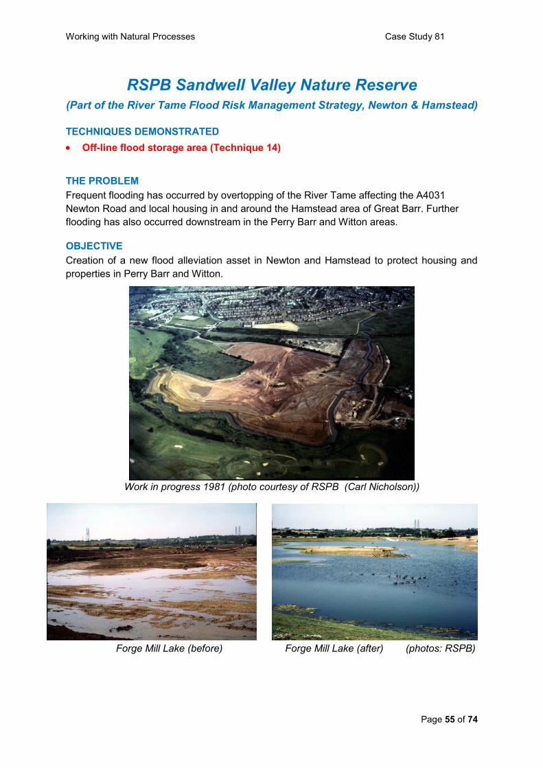
Working with Natural Processes Case Study 81
Page 55 of 74
RSPB Sandwell Valley Nature Reserve (Part of the River Tame Flood Risk Management Strategy, Newton & Hamstead)
TECHNIQUES DEMONSTRATED
Off-line flood storage area (Technique 14)
THE PROBLEM
Frequent flooding has occurred by overtopping of the River Tame affecting the A4031
Newton Road and local housing in and around the Hamstead area of Great Barr. Further
flooding has also occurred downstream in the Perry Barr and Witton areas.
OBJECTIVE
Creation of a new flood alleviation asset in Newton and Hamstead to protect housing and
properties in Perry Barr and Witton.
Work in progress 1981 (photo courtesy of RSPB (Carl Nicholson))
Forge Mill Lake (before)
Forge Mill Lake (after) (photos: RSPB)

Working with Natural Processes Case Study 81
Page 56 of 74
PROJECT DESCRIPTION
Flood alleviation work took place in Sandwell Valley in 1981. A large area of open water,
Forge Mill Lake, was created as a balancing lake by enlarging an existing depression. This
functions as an off line flood storage area.
When flows in the Tame reach a prescribed rate the water backs up at a flume, before
flowing over a spill bank and into Forge Mill Lake, where the water is retained by sluice
gates. When the river drops to normal levels pressure is relieved on the sluice gates, which
open, allowing water to flow out of Forge Mill Lake and back into the river.
Additionally, the River Tame was dredged and the resultant gravel was used to construct an
island within Forge Mill Lake. Several smaller islands were later created for habitat
enhancement.
PROJECT SUCCESS AND LESSONS
Flooding along the River Tame occurred in 1987, 2000 and 2007. Forge Mill Lake
successfully took up floodwater on all three occasions.
OTHER BENEFITS
The RSPB reserve features open water, reedbed, improved grassland, wet grassland, willow
carr, swamp/fen, scrub and a wildlife garden and so provides valuable habitat for waders,
wildfowl and warblers.
A large number of local individuals and groups enjoy the visitor centre and reserve.
ADDITIONAL INFORMATION
Project Location: Sandwell Valley Country Park, part of which comprises RSPB Sandwell
Valley Nature Reserve (10.3hectares), near West Bromwich, West Midlands.
Grid Reference: Forge Mill Lake SP 029 925 (RSPB Visitor Centre SP 035 928)
Water Body: River Tame
Associated Partners: RSPB, Sandwell Metropolitan Borough Council, Environment
Agency, Severn Trent Water.
Further information: Davinder Gill, The Environment Agency davinder.gill@environment-
agency.gov.uk
Lee Copplestone, RSPB Sandwell Valley Nature Reserve, 20 Tanhouse Avenue, Great Barr
Birmingham, B43 5AG (Tel 0121 357 7395) [email protected]

Working with Natural Processes Case Study 82
Page 57 of 74
Farming Floodplains for the Future, Staffordshire
TECHNIQUES DEMONSTRATED
Ditch blocking (Technique 4)
Arable reversion (Technique 5)
Flood plain woodland (Technique 6)
In-channel vegetation management (Technique 8)
On-line flood storage area (Technique 13)
THE PROBLEM The natural role of wetland habitats and river floodplains in the amelioration of flooding has
been lost over recent decades through river engineering and drainage. While the roles of
land management and land use in flood risk management have been identified at a strategic
level, questions remain over the reality and effectiveness of implementation in the wider
countryside.
OBJECTIVE
To work with farmers and landowners at a catchment scale to determine whether the farmed
landscape can be viably managed in ways that effectively reduce flood risk downstream,
while at the same time enhancing the natural environment.
PROJECT DESCRIPTION
Farming Floodplains for the Future is a partnership project hosted by Staffordshire Wildlife
Trust and funded over 3 years by Defra (through the Flood and Coastal Erosion Risk
Management Innovation Fund). It is concentrating on the catchments of the Rivers Sow and
Penk in lowland west Staffordshire. Seen as an important national pilot project, intended to
inform future policy direction, it has, through co-operation with the farming community,
focussed on practical implementation of solutions on the ground.
PROJECT SUCCESS AND LESSONS
Hydrological analysis (by JBA Consulting) showed rural run-off to be a major factor in the
causes of flooding here, with rural tributaries making a substantial contribution to flood risk,
particularly in the market town of Stafford. The work also highlighted the need to take a
catchment-wide approach incorporating headwaters and smaller tributaries – with the larger
areas of floodplain associated with the main rivers already operating at full capacity, the key
to success is dealing with water much closer to where it falls, utilising a number of sites to
provide cumulative reductions in downstream flood risk.
The project has seen a positive response from farmers and landowners, with visits
undertaken to over 50 sites. This has resulted in the implementation of a number of
schemes, demonstrating use of a range of techniques:-
Amending the routine maintenance operations of the Sow & Penk IDB

Working with Natural Processes Case Study 82
Page 58 of 74
Re-connection of floodplains (with associated creation and restoration of wetland
habitats)
Utilisation of existing ponds for on-line flood storage
Creation of new off-line flood storage
Planting of floodplain woodland
Use of woody debris in channels
Diversion of watercourses
The key success of the project is to show that land use change can be made at a catchment
scale (witnessed by the delivery of a dozen schemes on the ground), and in ways that are
both cost effective and environmentally sustainable. It is anticipated that the project results
will show that cumulative benefits can be secured through the promotion of natural
processes and land use change.
Functioning local flood storage scheme Debris dam (Photos courtesy of Matt Jones, Staffordshire Wildlife Trust)
OTHER BENEFITS
In addition to flood management benefits, the project has delivered habitat gains, including
creation and restoration /enhancement of floodplain grazing marsh, rush pasture, lowland
meadow, ponds/scrapes, broadleaved woodland and watercourses themselves. Benefits
have also been secured for individual farm businesses including new agri-environment
payments and enhanced land management opportunities.

Working with Natural Processes Case Study 82
Page 59 of 74
ADDITIONAL INFORMATION
Project Location: West Staffordshire
Water Body: Catchments of the Rivers Sow and Penk
Grid Reference: SJ 92 (indicative)
Key Partners: Staffordshire Wildlife Trust, Environment Agency, Natural England, Sow &
Penk IDB, Staffordshire County Council, FWAG, Defra
Cost: Total Funding from Defra – £294,485. Range of expenditure on site works-£2,500 to
£18,500
Further Information: Matt Jones, Wetlands Officer, Staffordshire Wildlife Trust
E-mail: [email protected]
The project is due to report at the end of March 2010, at which time more detailed results,
discussion documents and site specific case studies will be available. These will be later
published at a number of locations, notably on the Defra website.
Working with Natural Processes Case Study 83
Page 60 of 74
Black Water, New Forest, Hampshire
TECHNIQUES DEMONSTRATED
Woody debris dams (Technique 3)
Selective bed raising (Technique 10)
Re-meandering straightened rivers (Technique 16)
THE PROBLEM Past management action in the New Forest has straightened and deepened rivers and
created drainage ditches resulting in substantially increased erosion, and in some places this
has led to the river being unable to „self mend‟. A survey conducted by the Environment
Agency in 1996 found that over 100km of New Forest river channels showed signs of
degradation.
OBJECTIVE
To restore 604 hectares of priority interest features of the New Forest SAC and their
supporting adjacent habitats in accordance with the SAC Management Plan
To establish the long term sustainability of all six water basins through the
development of a mechanism which ensures their integrated management
The creation of suitable conditions for the regeneration of a significant further area of
priority habitat
PROJECT DESCRIPTION
This four year, 40% European funded, partnership project was set up in 2002 and co-
ordinated by Hampshire County Council. The project concentrated on the Lymington River,
Avon Water and Hampshire Avon water basins since these systems together contain the
largest areas of riverine and bog woodland within the New Forest.
The project has restored 10km of river channel by implementing the following techniques:
constructing and installing debris dams – These occur naturally in the forest, e.g. by a tree
falling over and forming a partial blockage which then impedes transport of further woody
debris, thus forming a woody dam. They play an important role in maintaining water levels in
the adjacent wetland areas and slow down water flows; re-installing and
connecting disconnected meanders using evidence of previous meanders from the modified
river systems; and raising river bed-levels using spoil originally removed from the channels.

Working with Natural Processes Case Study 83
Page 61 of 74
An excavator creating a debris dam A meander recreated on the Black Water (Photos courtesy of Forestry Commission)
PROJECT SUCCESS AND LESSONS
River restoration work totalling 10 Km has been successfully carried out by the Environment
Agency along the Black Water and the Highland Water. This is one of the largest river
restoration projects in the UK. Work has included the re-connection of old meanders, raising
of bed levels, and installation of debris dams. The results of these works are more natural,
slower flowing river systems that now have the ability to overflow onto their floodplains.
The introduction of large woody debris together with channel re-meandering has increased
flood attenuation and is reported as having a net positive impact on downstream flood risk.
OTHER BENEFITS
The four-year project has achieved the restoration of 261 hectares of riverine woodland, 18
hectares of bog woodland, 184 hectares of valley mire, and 141 hectares of wet grassland.
1330 ha of SSSI units have been moved into recovering condition.
ADDITIONAL INFORMATION
Project Location: New Forest, Hampshire
Water Body: River basins of the Lymington River, Hampshire Avon, and the Avon Water.
Grid Reference: SU 2306
Associated Partners: Forestry Commission, Natural England, Environment Agency,
National Trust, RSPB.
Cost: £2.9m
Further Information:
Text taken from the Forestry Commission website http://www.forestry.gov.uk/forestry/infd-
6argj3
and the New Forest Life website http://www.newforestlife.org.uk/life3/intranet2.htm

Working with Natural Processes Case Study 85
Page 62 of 74
Colne Brook, Slough
TECHNIQUES DEMONSTRATED
Removal of in-channel constriction (Technique 25)
THE PROBLEM
A mill weir (rebuilt in the 1990‟s) with limited flood flow capacity ponds water upstream
leading to significant siltation and excessive summer weed growth.
OBJECTIVE
To safely remove the impounding structure so as to improve flood capacity and lower the
retained water level in the upstream reach in order to reduce siltation and the volume of
weed growth.
PROJECT DESCRIPTION
The Colne Brook is part of the complex River Colne system near Slough to the west of
London. A flood risk management project was undertaken by the Environment Agency to
reduce flood risk to Colnbrook village.
Following a feasibility study, hydraulic modelling, detailed design and planning consent
including local consultation, work was completed in 2005. One part of the overall scheme
entailed removing the fish pass component of the weir, which lowered water levels at the
weir by 0.70 metre, with the effect extending upstream for 225 metres to the next control
structure.
Weir and fish pass before removal After removal of fish pass
(Photos courtesy of Andrew Pepper)

Working with Natural Processes Case Study 85
Page 63 of 74
PROJECT SUCCESS AND LESSONS
No work was carried out in the channel upstream of the weir, but shortly after the fishpass
was removed the river formed its own narrow meandering channel. Siltation no longer
occurs; neither does the abundance of choking water weed that was once a feature of this
reach.
In-channel vegetation before.... .... and after weir removal (Photo courtesy of Martin Janes) The silt banks have become vegetated and are now resistant to erosion, and so there have
been no noticeable changes to the reach geomorphology following flood flows.
The only (slight) objection to the work was from a nearby resident who claimed (prior to the
works) that he liked to hear the sound of water flowing across the weir and through the
fishpass. However, he did not take this further and has not complained since the works
were completed.
ADDITIONAL INFORMATION
Project Location: Colnbrook, Slough
Water Body: Colne Brook
Grid Reference: TQ 029 772
Further Information: Contact the Project Manager, Andrew Pepper
Email: [email protected]

Working with natural processes to manage flood and coastal erosion risk
Page 64 of 74
Section 6 References and further information
References
Bird et al (2003). S.B. Bird, B.A. Emmett, F.L. Sinclair, P.A. Stevens, B.Reynolds,
S.Nicholson and T.Jones (2003). Pontbren: Effects of tree planting on agricultural soils and
their functions. CEH Centre for Ecology and Hydrology, University of Wales, Bangor.
Cabinet Office (2008) The Pitt Review: Lessons learned from the 2007 floods. Sir Michael
Pitt. http://archive.cabinetoffice.gov.uk/pittreview/thepittreview/final_report.html
DCLG (2008). Planning Policy Statement 25: Development and Flood Risk Practice Guide.
Department for Communities and Local Government, 2008.
http://www.communities.gov.uk/archived/publications/planningandbuilding/pps25prac
ticeguide
Defra (2005) Making Space for Water - Taking forward a new Government strategy for flood
and coastal erosion risk management in England - First Government response to the autumn
2004 Making Space for Water consultation exercise.
http://www.defra.gov.uk/environ/fcd/policy/strategy.htm
Defra (2007). An introductory guide to valuing ecosystem services; Defra 2007.
http://www.defra.gov.uk/wildlife-countryside/pdf/natural-environ/eco-valuing.pdf
Defra (2008). The Government‟s Response to Sir Michael Pitt‟s Review of the summer 2007
Floods.
Defra (2009a). Appraisal of flood and coastal erosion risk management. A Defra policy
statement http://www.defra.gov.uk/environ/fcd/guidance/pagn/flood-coast-erosion-
manage.pdf
Defra (2009b) Draft Flood and Water Management Bill
http://www.official-documents.gov.uk/document/cm75/7582/7582.asp
Environment Agency (2008a) R&D. Delivery of Making Space for Water: HA6 Catchment
Scale Land-Use Management; HA7 Land Management Practices - The role of land use and
land management in delivering flood risk management final report. Halcrow Group Ltd.
Environment Agency (2008b), Identification of catchments sensitive to land use change:
Final Report, (Halcrow Group Ltd), 2008.
Environment Agency (2009). Ripon Multi-Objective project - Phase 2 Final Report (Halcrow
Group Ltd.)

Working with natural processes to manage flood and coastal erosion risk
Page 65 of 74
Environment Agency (2010). Flood and coastal erosion risk management - appraisal
guidance. Environment Agency, 2010.
Evans et al (2008). Evans, E.P., Simm, J.D., Thorne, C.R., Arnell, N.W., Ashley, R.M., Hess,
T.M., Lane,S.N., Morris, J., Nicholls, R.J., Penning-Rowsell, E.C., Reynard, N.S., Saul, A.J.,
Tapsell, S.M., Watkinson, A.R., Wheater, H.S. (2008) An update of the Foresight Future
Flooding 2004 qualitative risk analysis. Cabinet Office, London.
King and Lester (1995). King, S.E., Lester, J.N., The value of a salt marsh as a sea defence.
Marine Pollution Bulletin, vol 30, issue 3, pp 180-189.
Natural England (2009). Establishing a practical framework for schemes which integrate
flood-risk management and biodiversity. Final project report (Halcrow Group Ltd.)
RSPB (2010). Managing floods for people and wildlife: An RSPB Perspective. RSPB, 2010
(in production).
Further information
Commission for Architecture and the Built Environment (CABE) www.cabe.org.uk
Defra funded multi-objective land management projects:
http://www.defra.gov.uk/news/latest/2009/flood-0318.htm
Information on the multi-objective land use management project at Pickering:
http://www.forestresearch.gov.uk/slowingtheflow
Restoring wetlands in Sussex: www.sussexotters.org
River Restoration Centre: www.therrc.co.uk
Wetland Vision: http://www.wetlandvision.org.uk/

Working with natural processes to manage flood and coastal erosion risk
Page 66 of 74
Glossary of Terms
BAP Biodiversity Action Plan. A plan agreed at a national, regional or
local level to protect or enhance threatened habitats or species.
Canalisation The practice of constraining a watercourse into an artificial
channel. Typically would involve straightening a watercourse for
flood conveyance or land drainage purposes.
Coastal erosion A process where material is worn away from the coast due to an
imbalance in the supply and removal of matter. This covers the
loss of natural or constructed coastal defences such as sand
dunes and sea walls, as well as cliffs, land and intertidal areas.
Coastal squeeze The process by which coastal habitats and natural features are
progressively lost because they are prevented from migrating
landwards in response to sea level rise.
FAS Flood alleviation scheme. A project to manage flood risk.
FCERM Flood and coastal erosion risk management.
FRM Flood risk management. See above
Managed realignment The deliberate process of setting back defences, either to a new
retreated line of defence or to naturally rising ground. Can occur
at the coast or within a river floodplain.
Moorland gripping The practice of digging ditches to drain wet areas of moor. Hence
“grip blocking” to reverse this process.
Natural processes In the context of FCERM these are processes such as soil
infiltration, groundwater recharge and discharge, the erosion
conveyance and deposition of sediment, and coastal evolution
that naturally operate without human intervention. Greater
working with natural processes seeks to work more with these
processes and natural features such as upland moors, wetlands,
floodplains, and intertidal zones to sustainably manage flood and
coastal erosion risk.
Non-structural solutions Those flood management activities which are planned to
eliminate or mitigate adverse effects of flooding without involving
the construction of flow-modifying structures. For example, flood
warning, emergency response plans, development control and
floodplain management.
Project appraisal The process of defining the problem, setting objectives,
examining options and weighing up costs, impacts (positive and
negative), risks and uncertainties in order to make a decision
regarding the preferred solution.
Regulated tidal exchange (RTE)
The controlled inflow and outflow of sea water to an area behind
a fixed flood defence through the use of engineered structures
such as sluices, tide-gates or pipes. May be undertaken to create
saline or brackish habitats or to assist in raising land levels
(through sediment deposition).
Return period The average interval in years between events of similar or
greater magnitude (for example, a flow with a return period of 1

Working with natural processes to manage flood and coastal erosion risk
Page 67 of 74
in 100 years will be equalled or exceeded on average once in
every 100 years). However, this does not imply regular
occurrence, more correctly the 100-year flood should be
expressed as the event that has a 1% probability of being met or
exceeded in any one year.
River planform The shape of a river channel when viewed as on a map or plan.
Run-off Rainfall (or snow melt) that runs off the surface of the ground
towards a watercourse (in comparison to that which soaks into
the ground).
Sustainable A management approach that seeks to maximise the likelihood
that a solution delivered now does not adversely impact on the
ability of future generations to meet their needs. Implicit in this is
a recognition of social, economic and environmental limits and, in
the context of FCERM, an awareness of processes such as
coastal evolution, land use trends, and climate change.

Working with natural processes to manage flood and coastal erosion risk
Page 68 of 74
Appendix 1 Long list of case studies
In the preparation of this Guidance a list of possible case studies was prepared and is
reproduced here for reference. For ease of cross-reference the original case study
numbering has been retained and is reflected in the numbering of the case studies
presented in Section 5.
The case studies currently used in this Guidance are highlighted thus and also presented in Table 5.1.
Case Study No.
Case Study Title Primary Technique(s)
Location
1 Bowland Estate SCaMP 2 NW England - Forest of Bowland
2 Whitfield Moor 2 North Pennines
3 New Forest LIFE 3, 4 S England - New Forest
4 Great Triley Wood 3 Wales - Usk catchment, near Abergavenny
5 Clayton Flixton Carrs 4,5,6 North Yorkshire's Vale of Pickering
6 Doxey & Tillington WLMP 12 Stafford
7 Beckingham Marshes 11 Gainsborough, Nottinghamshire
8 River Parrett model assessment 6 Somerton, Somerset
9 Defra study – Ripon 1, 6 Yorkshire
10 Landscapes for Lapwings 7 Midlands (upper Thames tributaries).
11 Caldew & Carlisle FAS 9 NW England - Carlisle
12 Tutbury Mill 10, 16 Staffordshire
13 Sinderland Brook 16 Cheshire
14 Mid Cornwall Moors 12 SW England - Cornwall
15 Bannister Hall FAS 25 NW England
16 Cottage Pasture FAS 9 N England
17 Tirmynach FAS 9 Wales
18 Ouse Washes habitat creation 11 East Anglia

Working with natural processes to manage flood and coastal erosion risk
Page 69 of 74
Case Study No.
Case Study Title Primary Technique(s)
Location
19 Long Itchington FDIS 9 Midlands
20 Botany Farm 12 Suffolk
21 Yarnfield FAS 13 Midlands (Staffs)
22 Cobbins Brook FAS 12, 13 Waltham Abbey, Essex
23 Lochinvar FAS 13 NW England
24 Ings Beck FAS 13, 25 N England - Yorkshire
25 Waddington (Lowfields) 24 Midland - Lincoln
26 Venford Reservoir 14 SW England
27 Roding Enhancement 21 Greater London
28 Bonesgate River / Hogsmill 10, 15, 16 Surrey
29 Oakley Beck / Oakley Cross Beck 16 NE England
30 Congresbury Yeo 17 SW England - Somerset Levels
31 Dartford Creek Frontages FDS 21 SE England - Kent
32 Hesketh Out Marsh 17 Lancashire, River Ribble Estuary
33 River Quaggy, Sutcliffe Park 9,10,12,13,15,16 SE London
34 Wallasea Island (Defra scheme) 17 SE England - Essex
35 Greatham North 17 NE England, Clevedon
36 Orcheton, Erme estuary 17 SW England - Devon
37 Goosemoor, Exe Estuary 18 Devon
38 Dark Water, Hants 18 S England - New Forest
39 Blackhole Marsh, Seaton 18 SW England - Devon
40 Eastoke Hayling Island 21 S England - Hampshire
41 Hunstanton/Heacham Beach Management
21 Norfolk (The Wash)

Working with natural processes to manage flood and coastal erosion risk
Page 70 of 74
Case Study No.
Case Study Title Primary Technique(s)
Location
42 Newbiggin Bay Beach Recharge 21 NE England - Northumberland
43 Rolls Royce Chichester 23 S England - West Sussex
44 Sefton dunes 21 NW England - Merseyside
45 Camber Sands dunes 21 S England - Sussex
46 Boscastle FAS 15, 22 SW England
47 Harnham FAS 24 S. England, Salisbury
48 Lower Clyst 18 Devon
49 Brancaster 17 Norfolk
50 Otmoor 5, 7, 12 Oxfordshire
51 River Petteril, inc Durranhill Flood Storage Area
1 Cumbria
52 Ethelred Housing estate 23 Lambeth, London
53 Cumbria Wetlands project 2, 4, 5, 7, 9 NW England - Cumbria
54 Long Preston Deeps 4, 5, 7, 9, 12 North Yorkshire
55 Conwy Valley FAS 9 North Wales
56 River Erewash 7,14,15,16 Derbyshire
57 Great and Long Eau 9, 10,11 Lincolnshire
58 Bear Brook 12,13 Buckinghamshire
59 Fordingbridge FAS 11,12,14 S England, New Forest
60 Quinton Business Park 7 West Mids - Birmingham
61 Quedgeley Business Park 22 Gloucs
62 Trentham Gardens 22 Staffs
63 Adnams Brewery, Southwold 23 Suffolk
64 Pool Innovation Centre 22 Cornwall
65 Frampton 4, 5, 12 Lincolnshire
66 Abbey Farm 4, 5, 12 Snape, Suffolk
67 Olympics Site 7, 22 24 East London

Working with natural processes to manage flood and coastal erosion risk
Page 71 of 74
Case Study No.
Case Study Title Primary Technique(s)
Location
68 A1 upgrade 7 Betweeen Bramham and Wetherby, Yorkshire
69 WWT SUDS Applications 22, 23 Various - WWT has a number of SUDS applications at each of its nine sites. The use of green roof technology can be found in five centres and surface water SUDS are applied to two car parks. Four sites treat foul water using reed-beds
70 East Head Chichester 20 S England - West Sussex
71 Dawlish Warren Sand Dunes 20 Devon
72 Easington 17 East Riding Yorkshire
73 Lincshore 20, 21 Lincolnshire
74 Ekostaden-Augustenborg SUDS retrofit 22, 23, 24 Malmo, Sweden
75 River Mark, Breda 9,14,16 Breda, North Brabant, The Netherlands
76 Pontbren 1 Powys, Wales
77 Jubilee River 14 S. England - Berkshire & Buckinghamshire
78 South Milton sands 19, 21 Devon
79 Northampton CVLR 24 West Midlands
80 R. Marden at Calne 16 Wiltshire
81 Sandwell Valley 14 West Midlands
82 Farming Floodplains for the Future
4, 5, 6, 8, 13 Staffordshire
83 Black Water, New Forest
3, 10, 16 Hampshire
84 Knepp Estate (case study in preparation)
6 Sussex
85 Colne Brook weir removal
25 Slough
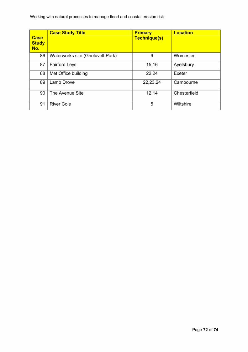
Working with natural processes to manage flood and coastal erosion risk
Page 72 of 74
Case Study No.
Case Study Title Primary Technique(s)
Location
86 Waterworks site (Gheluvelt Park) 9 Worcester
87 Fairford Leys 15,16 Ayelsbury
88 Met Office building 22,24 Exeter
89 Lamb Drove 22,23,24 Cambourne
90 The Avenue Site 12,14 Chesterfield
91 River Cole 5 Wiltshire

Working with natural processes to manage flood and coastal erosion risk
Page 73 of 74
Appendix 2 Project appraisal checklist The Defra policy statement on the appraisal of flood and coastal erosion schemes (Defra,
2009a) identifies that “an understanding of natural processes is important to ensure that the
impacts of different options are properly appraised and opportunities to work with nature to
reduce risk are identified”.
That understanding should start at the catchment or coastal cell level and reflect an
awareness of the natural processes driving flood propagation or coastal evolution
(techniques are described in Section 4 of this guidance and case studies illustrating the
application of these techniques are given in Section 5). The following checklist is intended as
a prompt for those undertaking FCERM project appraisals.
Working with natural processes checklist for project appraisal
Does the project appraisal demonstrate an informed understanding of the natural
processes at work in the catchment, how these currently influence flood and erosion
risk, and how this might change over the lifespan of the project? (An informed
understanding might reflect the conclusions of the current strategic overview plans
and / or scheme specific pluvial, fluvial, or coastal process reports).
In identifying the problem to be addressed does the appraisal reflect the influence of
current land use or coastal erosion risk management practices?
In identifying the problem to be addressed does the appraisal reflect the impact of
previous intervention and modification to natural processes?
Has the appraisal identified which option(s) best work with natural processes? If this
is not the preferred option does the project appraisal report explain why not?
Have the benefits of greater working with natural processes been fully appraised?
(For example, through the use of an ecosystem services approach to provide an
economic value to benefits such as increased carbon sequestration, biodiversity
gains, increased recreational opportunities, and improved aesthetics in addition to
the flood or erosion risk management benefit?).

Would you like to find out more about us,
or about your environment?
Then call us on
08708 506 506* (Mon-Fri 8-6)
or visit our website
www.environment-agency.gov.uk
incident hotline 0800 80 70 60 (24hrs)
floodline 0845 988 1188 * Approximate calls costs: 8p plus 6p per minute (standard landline). Please note charges will vary across telephone providers Environment first: This publication is printed on paper made from 100 per cent previously used waste. By-products from making the pulp and paper are used for composting and fertiliser, for making cement and for generating energy.