Embed Size (px)
Citation preview
This Ofqual regulated qualification is not available for candidates in maintained schools and colleges in Wales.
WJEC Eduqas GCSE (9-1) in
GEOLOGYACCREDITED BY OFQUAL
GCSE (9-1)
SAMPLE ASSESSMENT MATERIALSTeaching from 2017

GCSE GEOLOGY Sample Assessment Materials 1
© WJEC CBAC Ltd.
For teaching from 2017 For award from 2019 GCSE (9-1) GEOLOGY SAMPLE ASSESSMENT MATERIALS

GCSE GEOLOGY Sample Assessment Materials 3
© WJEC CBAC Ltd.
Contents
Page COMPONENT 1: Geological Principles Question paper 5 Data sheet 30 Mark scheme 33 COMPONENT 2: Investigative Geology Question paper 47 Map 1 62 Mark scheme 63

GCSE GEOLOGY Sample Assessment Materials 5
© WJEC CBAC Ltd.
Candidate Name Centre Number Candidate Number
0
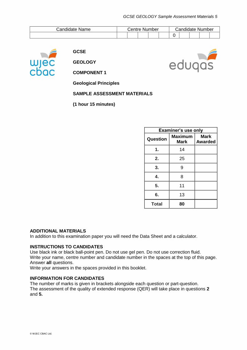
GCSE GEOLOGY COMPONENT 1 Geological Principles SAMPLE ASSESSMENT MATERIALS (1 hour 15 minutes)
ADDITIONAL MATERIALS In addition to this examination paper you will need the Data Sheet and a calculator. INSTRUCTIONS TO CANDIDATES Use black ink or black ball-point pen. Do not use gel pen. Do not use correction fluid. Write your name, centre number and candidate number in the spaces at the top of this page. Answer all questions. Write your answers in the spaces provided in this booklet. INFORMATION FOR CANDIDATES The number of marks is given in brackets alongside each question or part-question. The assessment of the quality of extended response (QER) will take place in questions 2 and 5.
Examiner’s use only
Question Maximum
Mark Mark
Awarded
1. 14
2. 25
3. 9
4. 8
5. 11
6. 13
Total 80
GCSE GEOLOGY Sample Assessment Materials 6
© WJEC CBAC Ltd.
Answer all questions.
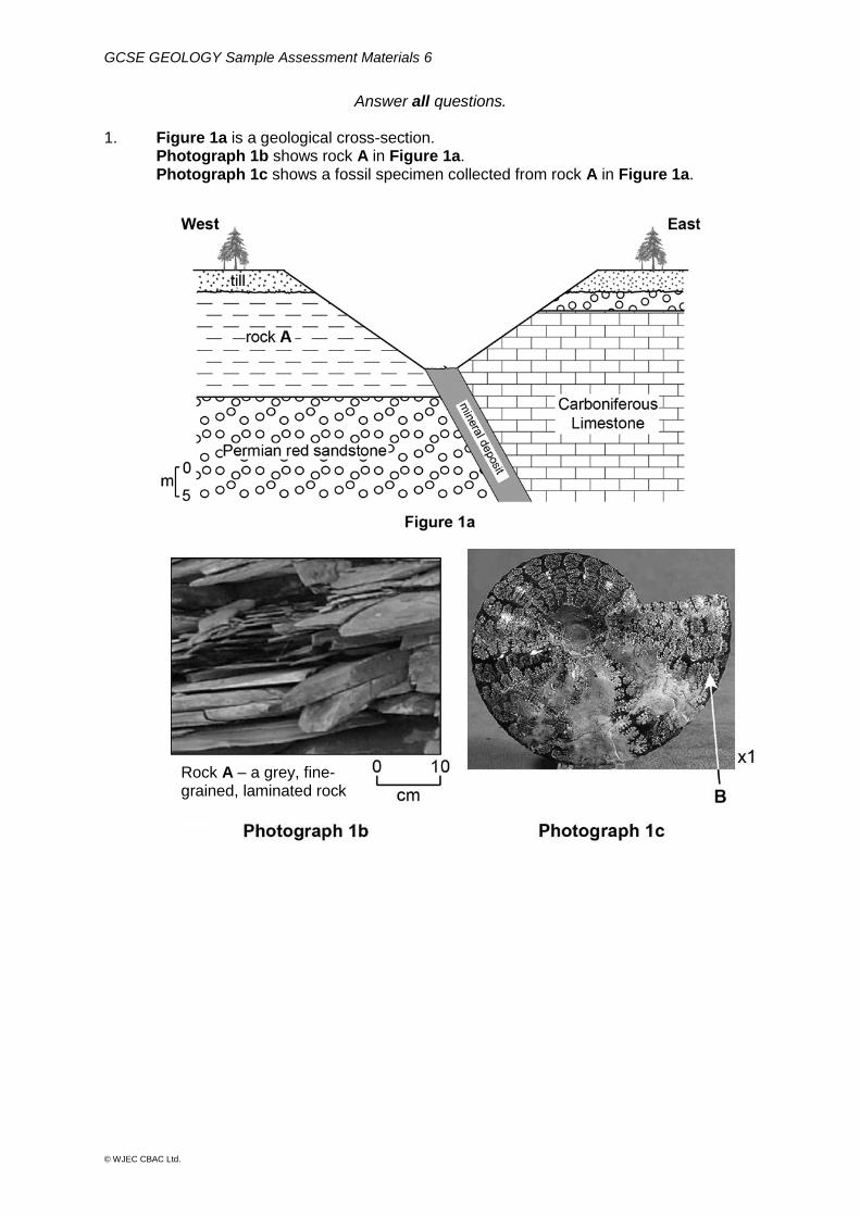
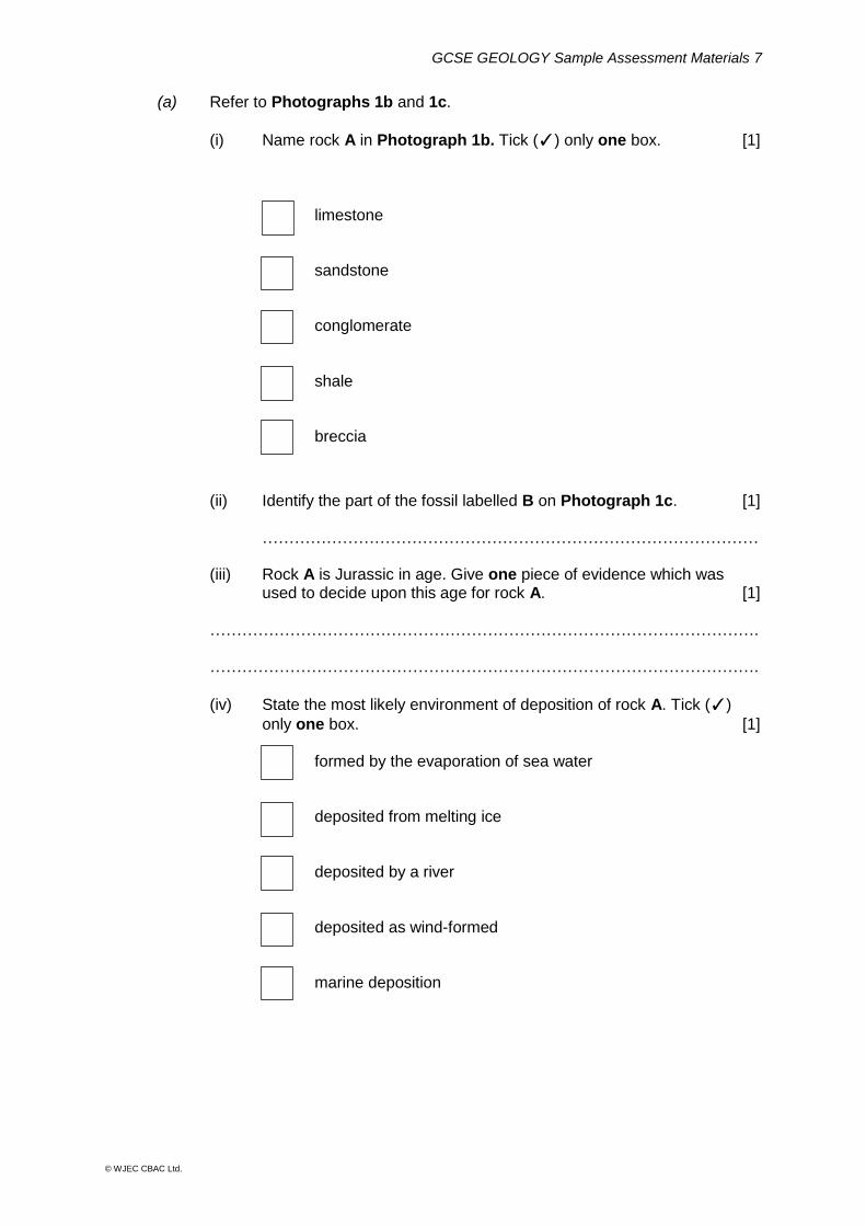
1. Figure 1a is a geological cross-section. Photograph 1b shows rock A in Figure 1a. Photograph 1c shows a fossil specimen collected from rock A in Figure 1a.
Rock A – a grey, fine-grained, laminated rock
GCSE GEOLOGY Sample Assessment Materials 7
© WJEC CBAC Ltd.
(a) Refer to Photographs 1b and 1c.
(i) Name rock A in Photograph 1b. Tick (✓) only one box. [1]
limestone
sandstone
conglomerate
shale
breccia
(ii) Identify the part of the fossil labelled B on Photograph 1c. [1] ………………………………………………………………………………… (iii) Rock A is Jurassic in age. Give one piece of evidence which was used to decide upon this age for rock A. [1] …………………………………………………………………………………………. ………………………………………………………………………………………….
(iv) State the most likely environment of deposition of rock A. Tick (✓)
only one box. [1] formed by the evaporation of sea water
deposited from melting ice
deposited by a river
deposited as wind-formed
marine deposition
GCSE GEOLOGY Sample Assessment Materials 8
© WJEC CBAC Ltd.
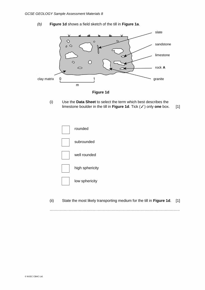
(b) Figure 1d shows a field sketch of the till in Figure 1a.
(i) Use the Data Sheet to select the term which best describes the
limestone boulder in the till in Figure 1d. Tick (✓) only one box. [1]
rounded
subrounded
well rounded
high sphericity
low sphericity
(ii) State the most likely transporting medium for the till in Figure 1d. [1] ………………………………………………………………………………………….
Figure 1d
clay matrix
slate
sandstone
rock A
limestone
granite
GCSE GEOLOGY Sample Assessment Materials 9
© WJEC CBAC Ltd.
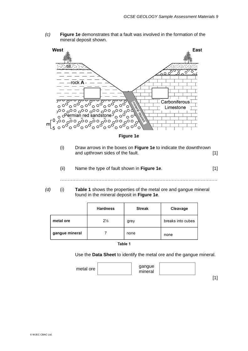
(c) Figure 1e demonstrates that a fault was involved in the formation of the
mineral deposit shown.
(i) Draw arrows in the boxes on Figure 1e to indicate the downthrown
and upthrown sides of the fault. [1]
(ii) Name the type of fault shown in Figure 1e. [1] …………………………………………………………………………………………. (d) (i) Table 1 shows the properties of the metal ore and gangue mineral
found in the mineral deposit in Figure 1e.
Use the Data Sheet to identify the metal ore and the gangue mineral.
metal ore gangue mineral
[1]
Figure 1e

GCSE GEOLOGY Sample Assessment Materials 10
© WJEC CBAC Ltd.
(ii) The mineral deposit in Figure 1e is a hydrothermal deposit. Explain how this hydrothermal deposit formed. [3] …………………………………………………………………………………............ …………………………………………………………………………………………. …………………………………………………………………………………………. …………………………………………………………………………………………. …………………………………………………………………………………………. …………………………………………………………………………………………. (iii) 7.5 x 10⁴ tonnes of mineral deposit were extracted, from which 3 x 10³
tonnes of metal ore were separated. Calculate the percentage of metal ore in the mineral deposit. Show your working. [2]
Percentage of metal ore = ………………. %
14
GCSE GEOLOGY Sample Assessment Materials 11
© WJEC CBAC Ltd.
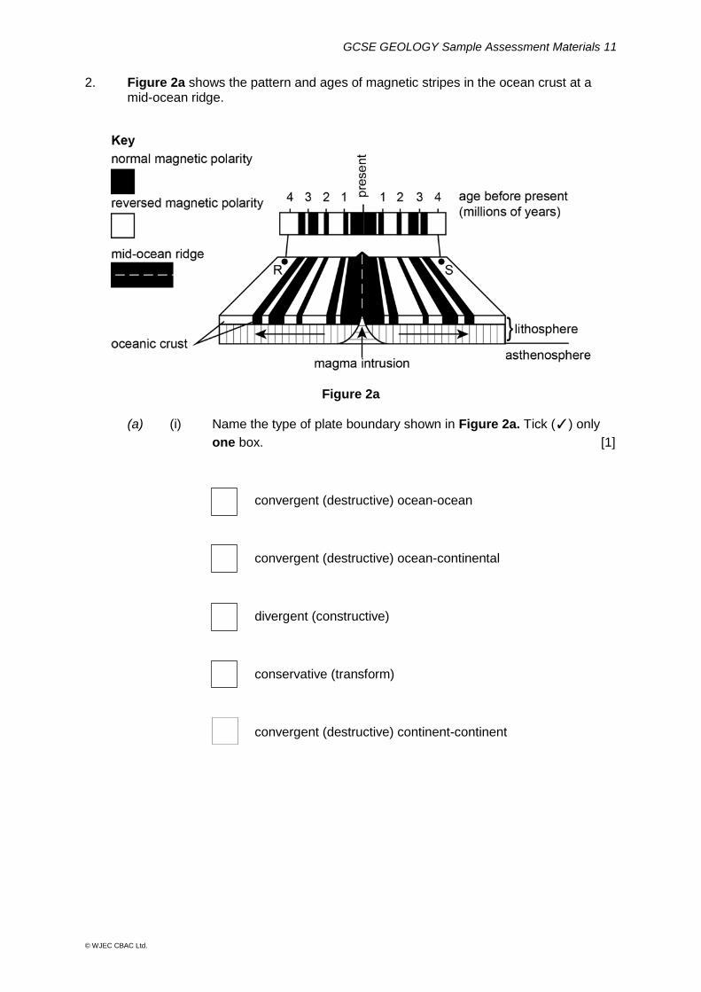
2. Figure 2a shows the pattern and ages of magnetic stripes in the ocean crust at a mid-ocean ridge.
Figure 2a
(a) (i) Name the type of plate boundary shown in Figure 2a. Tick (✓) only
one box. [1]
convergent (destructive) ocean-ocean
convergent (destructive) ocean-continental
divergent (constructive)
conservative (transform)
convergent (destructive) continent-continent
GCSE GEOLOGY Sample Assessment Materials 12
© WJEC CBAC Ltd.
(ii) Locations R and S in Figure 2a are 180 km apart on the ocean floor. State the mean distance, in centimetres, that R and S are spreading
away from each other in one year. Show your working. [2]
..………….. cm
(iii) Explain how the magnetic stripes in the rocks of the oceanic crust
were formed. [4]
………………………………………………………………………………………...
…........................................................................................................................
…………………………………………………………………………………………
…………………………………………………………………………………………
…………………………………………………………………………………………
…………………………………………………………………………………………
GCSE GEOLOGY Sample Assessment Materials 13
© WJEC CBAC Ltd.
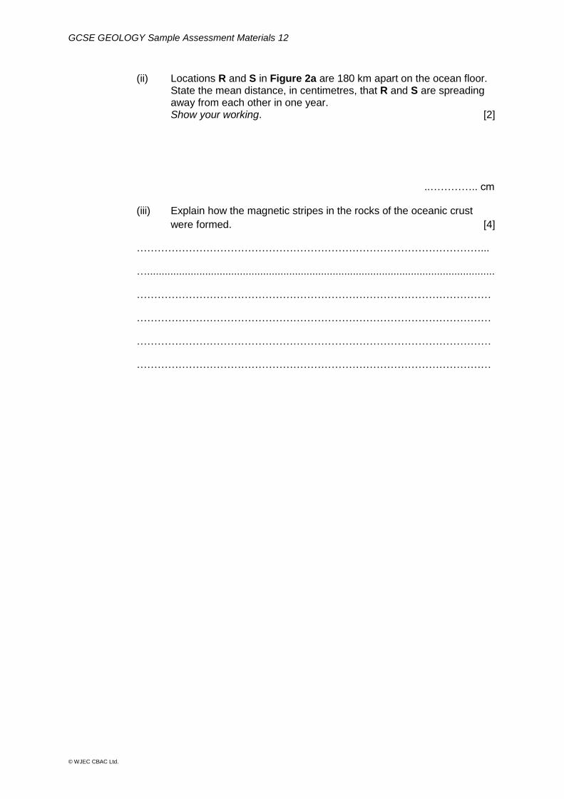
(b) Figure 2b is a graph showing the change in latitude of the British area
through geological time.
Figure 2b
Refer to Figure 2b.
(i) Using the Data Sheet, state during which geological period the British
area crossed the equator. [1]
…………………………………………………………………………………
(ii) Calculate the rate of change in latitude of the British area between 400
and 250 Ma.
Show your working. Give your answer to two significant figures. [3]
. …………. degrees ma-1
North
South
Latitude (degrees)
(degrees)
Age (Ma)

GCSE GEOLOGY Sample Assessment Materials 14
© WJEC CBAC Ltd.
(iii) Using the Data Sheet, state which two of the following statements
correctly interpret the information shown in Figure 2b. Tick (✓) only
two boxes. [2]
the rate of drift was constant the rate of drift was more rapid between 450 Ma and 250 Ma drift was away from the north pole during the Mesozoic drift was away from the equator during the Devonian the rate of drift slowed during the Mesozoic the rate of drift was faster in the Cenozoic than the Carboniferous
(iv) Indicate which of the following lines of evidence does not support the
theory of continental drift. Tick (✓) only one box. [1]
paleomagnetism
mass extinctions
fossil distributions
age of the ocean floor
jigsaw fit of opposing coastlines
GCSE GEOLOGY Sample Assessment Materials 15
© WJEC CBAC Ltd.
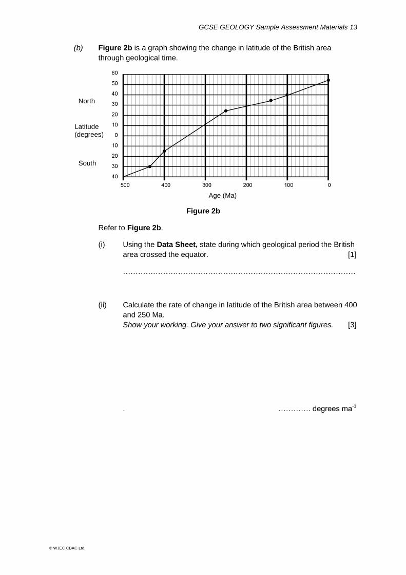
(c) Figure 2c is a graph showing the relative amounts of evaporite deposits
(such as halite) forming at different latitudes at the present day.
Figure 2c
(i) Refer to Figure 2c. Indicate between which latitudes most evaporite deposits are forming in the northern hemisphere.
Tick (✓) only one box. [1]
0⁰ - 10⁰
20⁰ - 30⁰
30⁰ - 40⁰
40⁰ - 50⁰
50 - 60⁰
(ii) In Cheshire in the UK there are evaporite deposits which are 200 metres thick.
On average a 5 centimetre thickness of evaporite is produced by the evaporation of 3 metres depth of sea water. Calculate the depth of sea water that must have evaporated to produce a 200 metre thick layer of evaporite. Show your working. [3]
Depth of sea water =……………………..m
GCSE GEOLOGY Sample Assessment Materials 16
© WJEC CBAC Ltd.
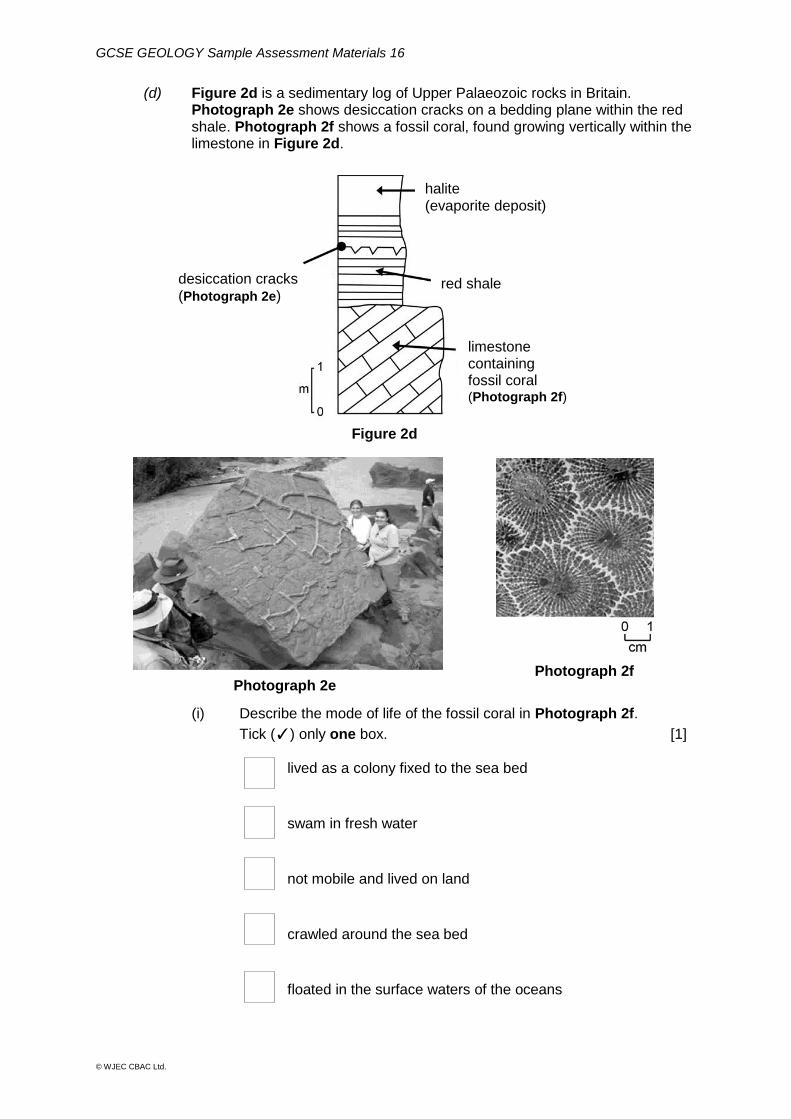
(d) Figure 2d is a sedimentary log of Upper Palaeozoic rocks in Britain. Photograph 2e shows desiccation cracks on a bedding plane within the red shale. Photograph 2f shows a fossil coral, found growing vertically within the limestone in Figure 2d.
Figure 2d
(i) Describe the mode of life of the fossil coral in Photograph 2f.
Tick (✓) only one box. [1]
lived as a colony fixed to the sea bed
swam in fresh water
not mobile and lived on land
crawled around the sea bed
floated in the surface waters of the oceans
Photograph 2e Photograph 2f
halite (evaporite deposit)
red shale desiccation cracks (Photograph 2e)
limestone containing fossil coral (Photograph 2f)
GCSE GEOLOGY Sample Assessment Materials 17
© WJEC CBAC Ltd.
(ii) Refer to Figures 2c and 2d, and Photographs 2e and 2f. Interpret
and evaluate the evidence for changes in the latitude of the British
area over geological time. [6 QER]
………………………………………………………………………………………….
………………………………………………………………………………………….
………………………………………………………………………………………….
………………………………………………………………………………………….
………………………………………………………………………………………….
………………………………………………………………………………………….
………………………………………………………………………………………….
………………………………………………………………………………………….
………………………………………………………………………………................
………………………………………………………………………………………….
………………………………………………………………………………………….
………………………………………………………………………………………….
………………………………………………………………………………………….
……………………………………………………………………………………........
………………………………………………………………………………………….
………………………………………………………………………………………….
………………………………………………………………………………………….
………………………………………………………………………………………….
………………………………………………………………………………………….
……………………………………………………………………………………….....
25
GCSE GEOLOGY Sample Assessment Materials 18
© WJEC CBAC Ltd.
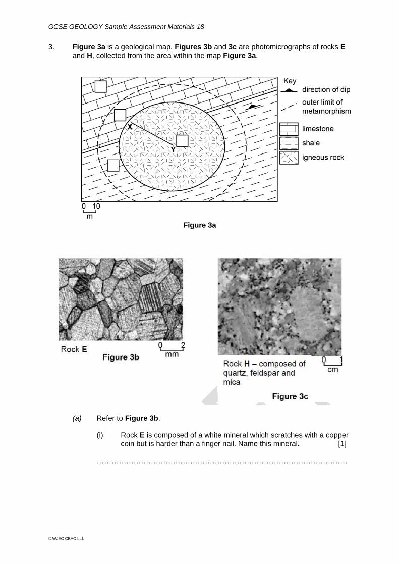
3. Figure 3a is a geological map. Figures 3b and 3c are photomicrographs of rocks E and H, collected from the area within the map Figure 3a.
Figure 3a
(a) Refer to Figure 3b.
(i) Rock E is composed of a white mineral which scratches with a copper coin but is harder than a finger nail. Name this mineral. [1]
…………………………………………………………………………………………
GCSE GEOLOGY Sample Assessment Materials 19
© WJEC CBAC Ltd.
(ii) Describe the texture of rock E in Figure 3b. Tick (✓) only two boxes.
[2]
crystalline
foliated
non-foliated
well sorted
fragmental (clastic)
schistose texture
(iii) Put a tick (✓) in one of the four blank boxes on Figure 3a to show the
most likely location of rock E. Give two reasons for your choice. [3]
1 ………………………………………………………………………………………..
………………………………………………………………………………………….
2 ……………………………………………………….……………………………….
………………………………………………………………………………………….
GCSE GEOLOGY Sample Assessment Materials 20
© WJEC CBAC Ltd.
(b) (i) Identify which one of the following processes in the rock cycle lead to
the formation of rock H in Figure 3c. Tick (✓) only one box. [1]
regional metamorphism
recrystallisation
crystallisation of magma
extrusion
rapid deposition
(ii) Explain why the size of the crystals in the igneous intrusion in Figure
3a becomes coarser along the line from X to Y. [2]
………………………………………………………………………………………….
………………………………………………………………………………………….
………………………………………………………………………………………….
…………………………………………………………………………………............
9
GCSE GEOLOGY Sample Assessment Materials 21
© WJEC CBAC Ltd.
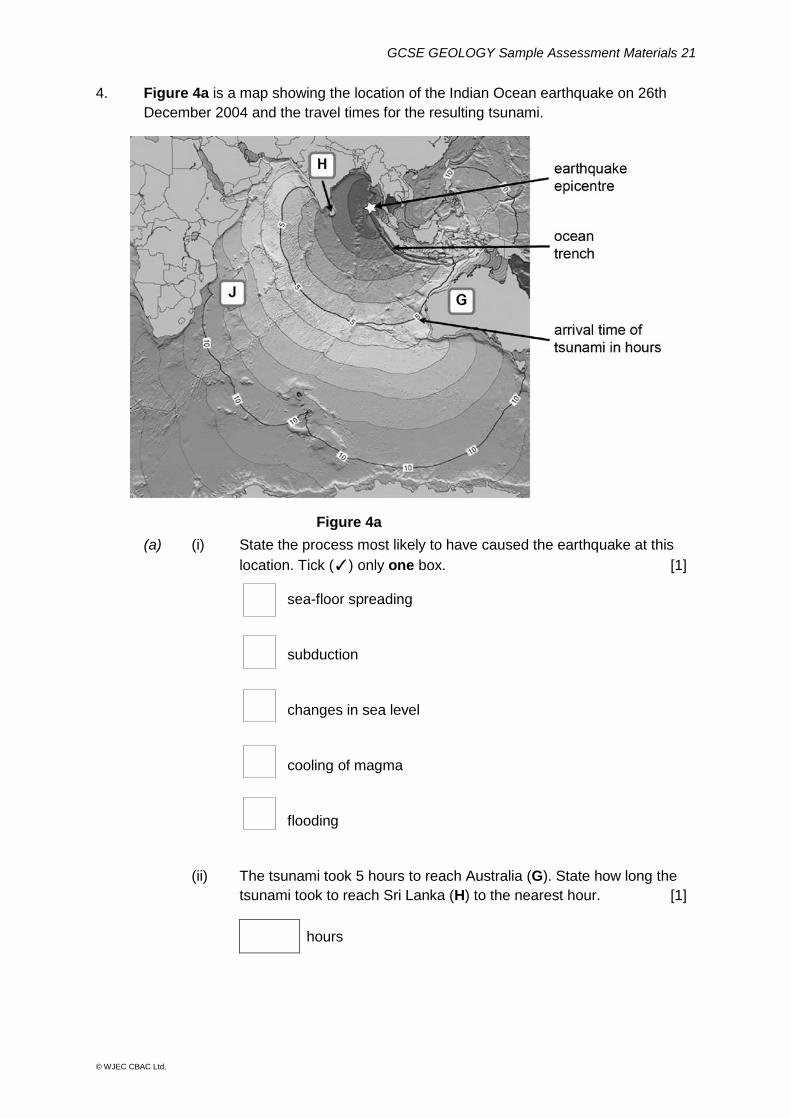
4. Figure 4a is a map showing the location of the Indian Ocean earthquake on 26th
December 2004 and the travel times for the resulting tsunami.
(a) (i) State the process most likely to have caused the earthquake at this
location. Tick (✓) only one box. [1]
sea-floor spreading
subduction
changes in sea level
cooling of magma
flooding
(ii) The tsunami took 5 hours to reach Australia (G). State how long the
tsunami took to reach Sri Lanka (H) to the nearest hour. [1]
hours
Figure 4a
GCSE GEOLOGY Sample Assessment Materials 22
© WJEC CBAC Ltd.
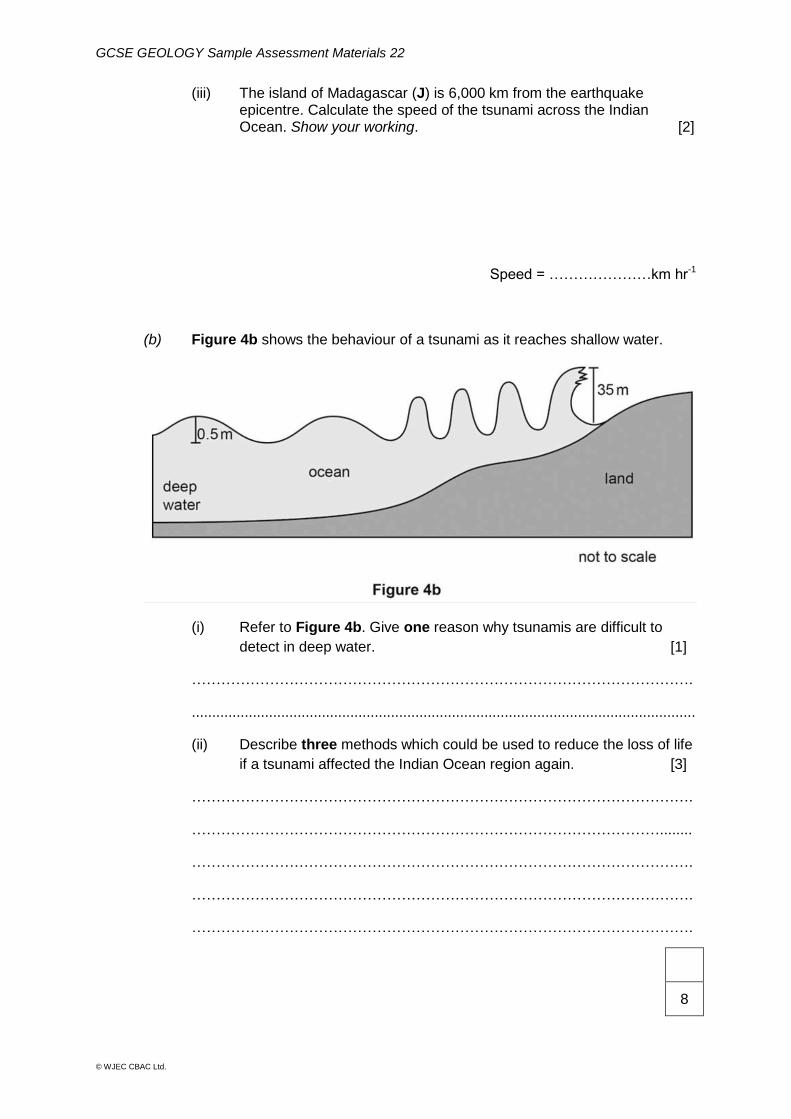
(iii) The island of Madagascar (J) is 6,000 km from the earthquake epicentre. Calculate the speed of the tsunami across the Indian Ocean. Show your working. [2]
Speed = …………………km hr-1
(b) Figure 4b shows the behaviour of a tsunami as it reaches shallow water.
(i) Refer to Figure 4b. Give one reason why tsunamis are difficult to
detect in deep water. [1]
………………………………………………………………………………………….
............................................................................................................................
(ii) Describe three methods which could be used to reduce the loss of life
if a tsunami affected the Indian Ocean region again. [3]
………………………………………………………………………………………….
……………………………………………………………………………………........
………………………………………………………………………………………….
………………………………………………………………………………………….
………………………………………………………………………………………….
8
GCSE GEOLOGY Sample Assessment Materials 23
© WJEC CBAC Ltd.
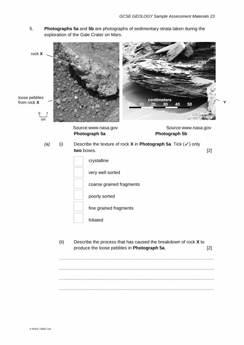
5. Photographs 5a and 5b are photographs of sedimentary strata taken during the
exploration of the Gale Crater on Mars.
Source:www.nasa.gov Source:www.nasa.gov
Photograph 5a Photograph 5b
(a) (i) Describe the texture of rock X in Photograph 5a. Tick (✓) only
two boxes. [2]
crystalline
very well sorted
coarse grained fragments
poorly sorted
fine grained fragments
foliated
(ii) Describe the process that has caused the breakdown of rock X to
produce the loose pebbles in Photograph 5a. [2]
………………………………………………………………………………………….
………………………………………………………………………………………….
………………………………………………………………………………………….
………………………………………………………………………………………….
rock X
loose pebbles
from rock X Y
GCSE GEOLOGY Sample Assessment Materials 24
© WJEC CBAC Ltd.
(b) Name the sedimentary structure labelled Y in Photograph 5b. Tick (✓) only
one box. [1]
graded bedding
cross bedding
unconformity
desiccation cracks
trace fossils (c) Refer to Photographs 5a and 5b and the principle of uniformitarianism. Analyse and interpret the evidence that enabled scientists to conclude that
the rocks at Gale Crater were deposited by water flowing towards the East. [6 QER]
………………………………………………………………………………………….
………………………………………………………………………………………….
………………………………………………………………………………………….
………………………………………………………………………………………….
………………………………………………………………………………………….
………………………………………………………………………………………….
………………………………………………………………………………………….
………………………………………………………………………………………….
………………………………………………………………………………................
………………………………………………………………………………………….
………………………………………………………………………………………….
………………………………………………………………………………………….
………………………………………………………………………………………….
GCSE GEOLOGY Sample Assessment Materials 25
© WJEC CBAC Ltd.
……………………………………………………………………………………........
………………………………………………………………………………………….
………………………………………………………………………………………….
………………………………………………………………………………………….
………………………………………………………………………………………….
………………………………………………………………………………………….
……………………………………………………………………………………….....
11
GCSE GEOLOGY Sample Assessment Materials 26
© WJEC CBAC Ltd.
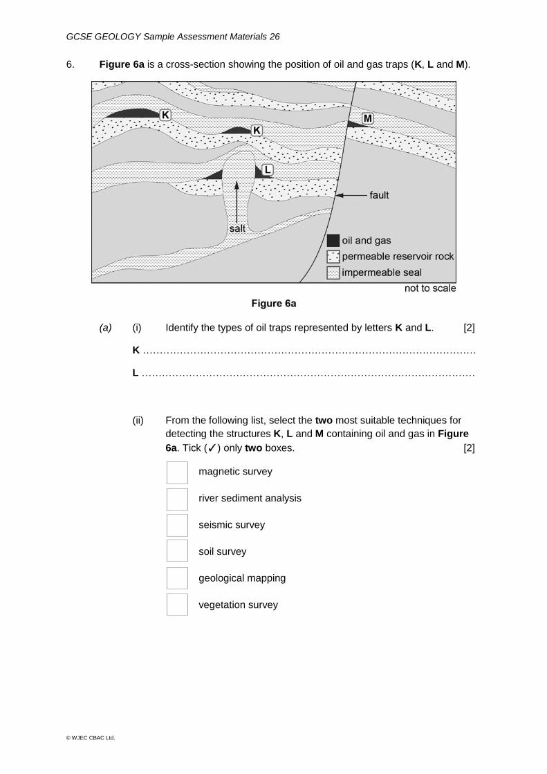
6. Figure 6a is a cross-section showing the position of oil and gas traps (K, L and M).
(a) (i) Identify the types of oil traps represented by letters K and L. [2]
K ………………………………………………………………………………………
L ………………………………………………………………………………………
(ii) From the following list, select the two most suitable techniques for
detecting the structures K, L and M containing oil and gas in Figure
6a. Tick (✓) only two boxes. [2]
magnetic survey
river sediment analysis
seismic survey
soil survey
geological mapping
vegetation survey
GCSE GEOLOGY Sample Assessment Materials 27
© WJEC CBAC Ltd.
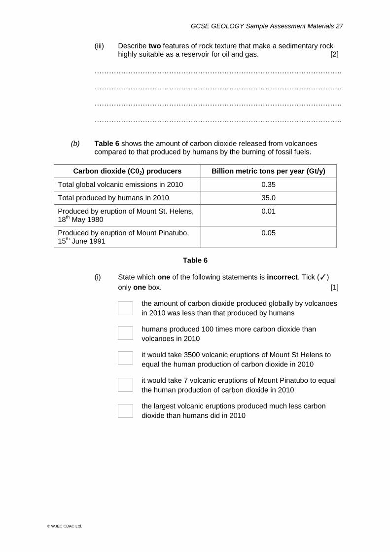
(iii) Describe two features of rock texture that make a sedimentary rock highly suitable as a reservoir for oil and gas. [2]
………………………………………………………………………………………….
………………………………………………………………………………………….
………………………………………………………………………………………….
………………………………………………………………………………………….
(b) Table 6 shows the amount of carbon dioxide released from volcanoes compared to that produced by humans by the burning of fossil fuels.
Carbon dioxide (C02) producers Billion metric tons per year (Gt/y)
Total global volcanic emissions in 2010 0.35
Total produced by humans in 2010 35.0
Produced by eruption of Mount St. Helens, 18th May 1980
0.01
Produced by eruption of Mount Pinatubo, 15th June 1991
0.05
Table 6
(i) State which one of the following statements is incorrect. Tick (✓)
only one box. [1]
the amount of carbon dioxide produced globally by volcanoes
in 2010 was less than that produced by humans
humans produced 100 times more carbon dioxide than
volcanoes in 2010
it would take 3500 volcanic eruptions of Mount St Helens to
equal the human production of carbon dioxide in 2010
it would take 7 volcanic eruptions of Mount Pinatubo to equal
the human production of carbon dioxide in 2010
the largest volcanic eruptions produced much less carbon
dioxide than humans did in 2010
GCSE GEOLOGY Sample Assessment Materials 28
© WJEC CBAC Ltd.
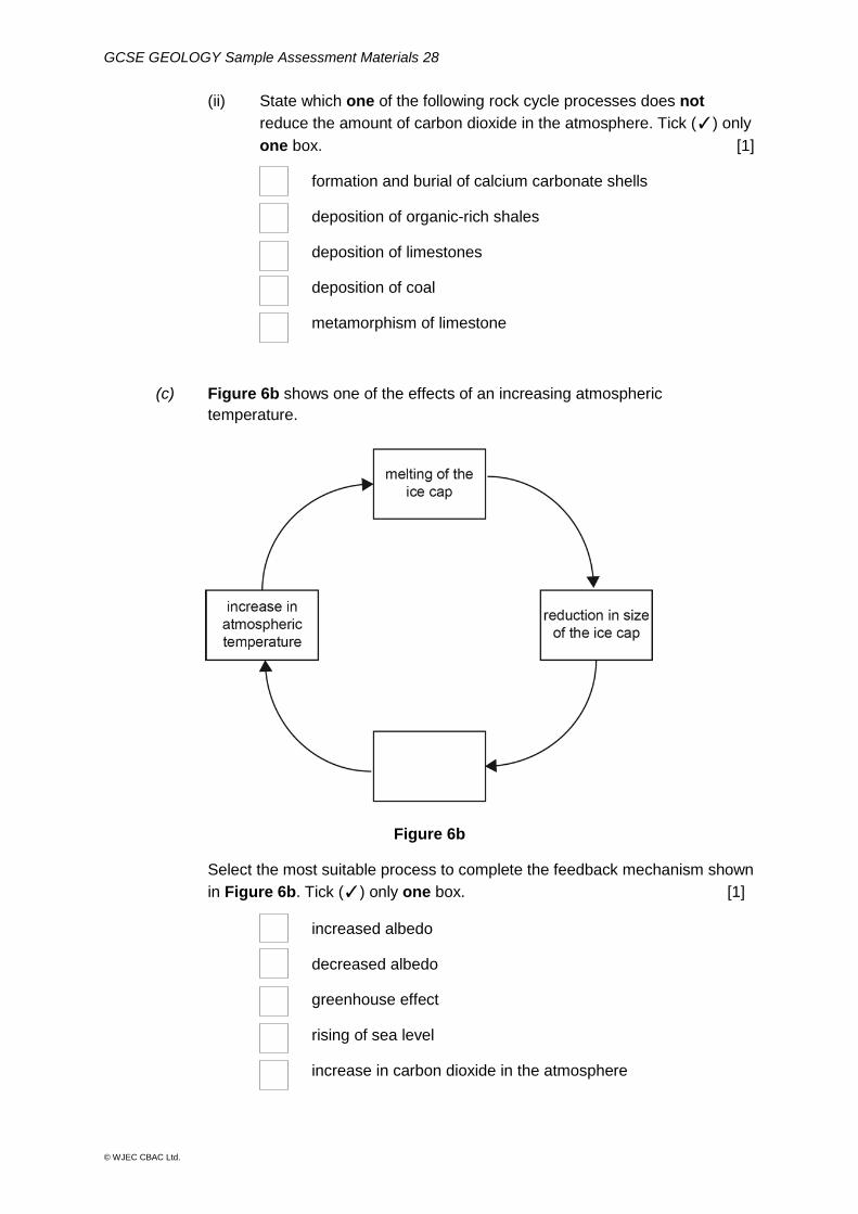
(ii) State which one of the following rock cycle processes does not
reduce the amount of carbon dioxide in the atmosphere. Tick (✓) only
one box. [1]
formation and burial of calcium carbonate shells
deposition of organic-rich shales
deposition of limestones
deposition of coal
metamorphism of limestone
(c) Figure 6b shows one of the effects of an increasing atmospheric
temperature.
Figure 6b
Select the most suitable process to complete the feedback mechanism shown
in Figure 6b. Tick (✓) only one box. [1]
increased albedo
decreased albedo
greenhouse effect
rising of sea level
increase in carbon dioxide in the atmosphere
GCSE GEOLOGY Sample Assessment Materials 29
© WJEC CBAC Ltd.
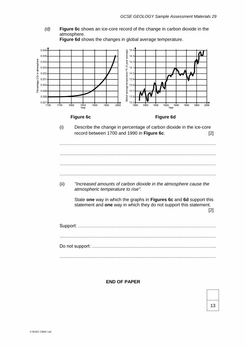
(d) Figure 6c shows an ice-core record of the change in carbon dioxide in the atmosphere. Figure 6d shows the changes in global average temperature.
Figure 6c Figure 6d
(i) Describe the change in percentage of carbon dioxide in the ice-core
record between 1700 and 1990 in Figure 6c. [2]
………………………………………………………………………………………….
………………………………………………………………………………………….
………………………………………………………………………………………….
………………………………………………………………………………………….
(ii) "Increased amounts of carbon dioxide in the atmosphere cause the atmospheric temperature to rise". State one way in which the graphs in Figures 6c and 6d support this statement and one way in which they do not support this statement. [2] Support: ……………………………………………………………………………….
………………………………………………………………………………………….
Do not support: ……………………………………………………………………….
………………………………………………………………………………………….
END OF PAPER
13

GCSE GEOLOGY Sample Assessment Materials 30
© WJEC CBAC Ltd.
GCSE GEOLOGY DATA SHEET
GCSE GEOLOGY Sample Assessment Materials 31
© WJEC CBAC Ltd.
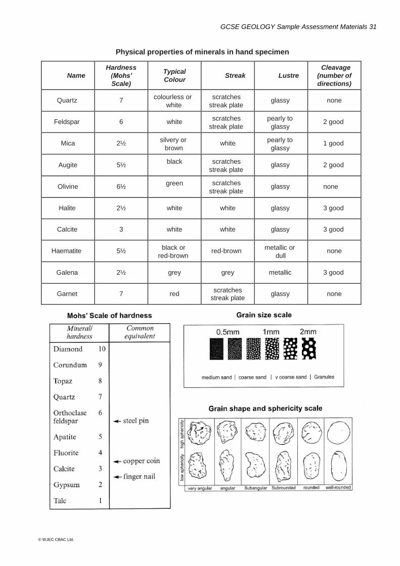
Physical properties of minerals in hand specimen
Name
Hardness
(Mohs’
Scale)
Typical
Colour Streak Lustre
Cleavage
(number of
directions)
Quartz 7 colourless or
white
scratches
streak plate glassy none
Feldspar 6 white scratches
streak plate
pearly to
glassy 2 good
Mica 2½ silvery or
brown white
pearly to
glassy 1 good
Augite 5½ black scratches
streak plate glassy 2 good
Olivine 6½ green scratches
streak plate glassy none
Halite 2½ white white glassy 3 good
Calcite 3 white white glassy 3 good
Haematite 5½ black or
red-brown red-brown
metallic or
dull none
Galena 2½ grey grey metallic 3 good
Garnet 7 red scratches
streak plate glassy none
GCSE GEOLOGY Sample Assessment Materials 32
© WJEC CBAC Ltd.
GCSE GEOLOGY Sample Assessment Materials 33
© WJEC CBAC Ltd.
WJEC Eduqas GCSE Geology
Mark scheme for use with Component 1
Geological Principles
SAMPLE ASSESSMENT MATERIALS
GCSE GEOLOGY Sample Assessment Materials 34
© WJEC CBAC Ltd.
Instructions for examiners of GCSE Geology when applying the mark scheme 1 Positive marking
It should be remembered that candidates are writing under examination conditions and credit should be given for what the candidate writes, rather than adopting the approach of penalising him/her for any omissions. It should be possible for a very good response to achieve full marks and a very poor one to achieve zero marks. Worthwhile answers that meet the requirements of the question, but do not appear on the mark scheme are to be given credit.
2 Tick marking
Low tariff questions should be marked using a points-based system. Each credit worthy response should be ticked in red pen. The number of ticks must equal the mark awarded for the sub-question. The mark scheme should be applied precisely using the marking details box as a guide to the responses that are acceptable. Do not use crosses to indicate answers that are incorrect.
3 Multiple choice marking
For all questions involving multiple choice (tick box) answers, where a candidate has ticked more than the required number of boxes, deduct 1 mark for each box which is wrongly chosen, to a minimum of 0. The answers to these questions are indicated with a * in the mark scheme. This applies to both on-screen and paper versions of Component 1.
4 Banded mark schemes
Banded mark schemes are divided so that each band has a relevant descriptor. The descriptor for the band provides a description of the performance level for that band. Each band contains marks. Examiners should first read and annotate a learner’s answer to pick out the evidence that is being assessed in that question. Do not use ticks on the candidate’s response. Once the annotation is complete, the mark scheme can be applied. This is done as a two stage process.
GCSE GEOLOGY Sample Assessment Materials 35
© WJEC CBAC Ltd.
Stage 1 – Deciding on the band When deciding on a band, the answer should be viewed holistically. Beginning at the lowest band, examiners should look at the learner’s answer and check whether it matches the descriptor for that band. Examiners should look at the descriptor for that band and see if it matches the qualities shown in the learner’s answer. If the descriptor at the lowest band is satisfied, examiners should move up to the next band and repeat this process for each band until the descriptor matches the answer.
If an answer covers different aspects of different bands within the mark scheme, a ‘best fit’ approach should be adopted to decide on the band and then the learner’s response should be used to decide on the mark within the band. For instance if a response is mainly in band 2 but with a limited amount of band 3 content, the answer would be placed in band 2, but the mark awarded would be close to the top of band 2 as a result of the band 3 content. Examiners should not seek to mark candidates down as a result of small omissions in minor areas of an answer. Stage 2 – Deciding on the mark Once the band has been decided, examiners can then assign a mark. During standardising (marking conference), detailed advice from the Principal Examiner on the qualities of each mark band will be given. Examiners will then receive examples of answers in each mark band that have been awarded a mark by the Principal Examiner. Examiners should mark the examples and compare their marks with those of the Principal Examiner. When marking, examiners can use these examples to decide whether a learner’s response is of a superior, inferior or comparable standard to the example. Examiners are reminded of the need to revisit the answer as they apply the mark scheme in order to confirm that the band and the mark allocated is appropriate to the response provided. Indicative content is also provided for banded mark schemes. Indicative content is not exhaustive, and any other valid points must be credited. In order to reach the highest bands of the mark scheme a learner need not cover all of the points mentioned in the indicative content but must meet the requirements of the highest mark band. Where a response is not creditworthy, that is contains nothing of any significance to the mark scheme, or where no response has been provided, no marks should be awarded.
GCSE GEOLOGY Sample Assessment Materials 36
© WJEC CBAC Ltd.
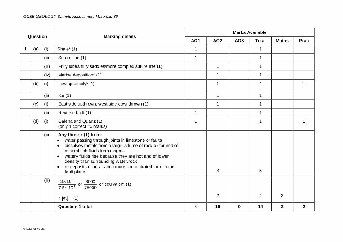
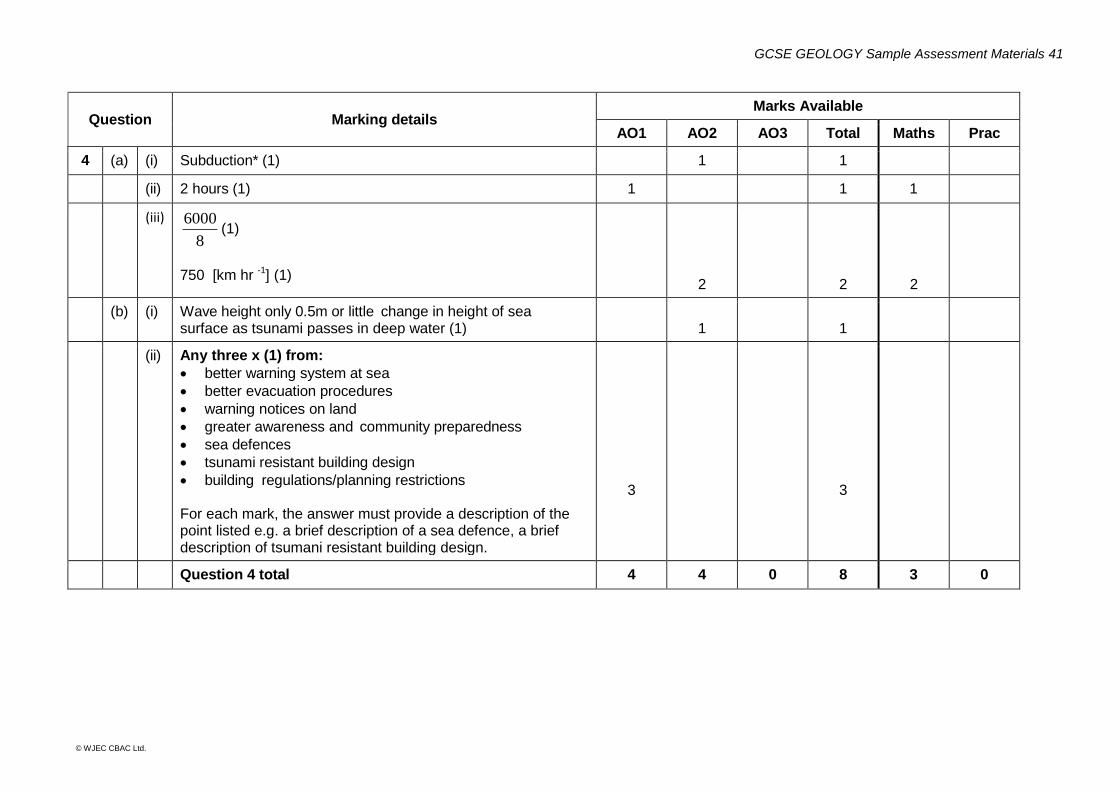
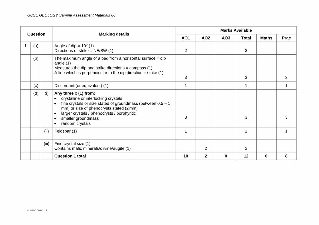
Question Marking details Marks Available
AO1 AO2 AO3 Total Maths Prac
1 (a) (i) Shale* (1) 1 1
(ii) Suture line (1) 1 1
(iii) Frilly lobes/frilly saddles/more complex suture line (1) 1 1
(iv) Marine deposition* (1) 1 1
(b) (i) Low sphericity* (1) 1 1 1
(ii) Ice (1) 1 1
(c) (i) East side upthrown, west side downthrown (1) 1 1
(ii) Reverse fault (1) 1 1
(d) (i) Galena and Quartz (1) (only 1 correct =0 marks)
1 1 1
(ii) Any three x (1) from:
water passing through joints in limestone or faults
dissolves metals from a large volume of rock or formed of mineral rich fluids from magma
watery fluids rise because they are hot and of lower density than surrounding water/rock
re-deposits minerals in a more concentrated form in the fault plane
3
3
(iii)
4
3
107.5
103
or
75000
3000 or equivalent (1)
4 [%] (1)
2
2
2
Question 1 total 4 10 0 14 2 2
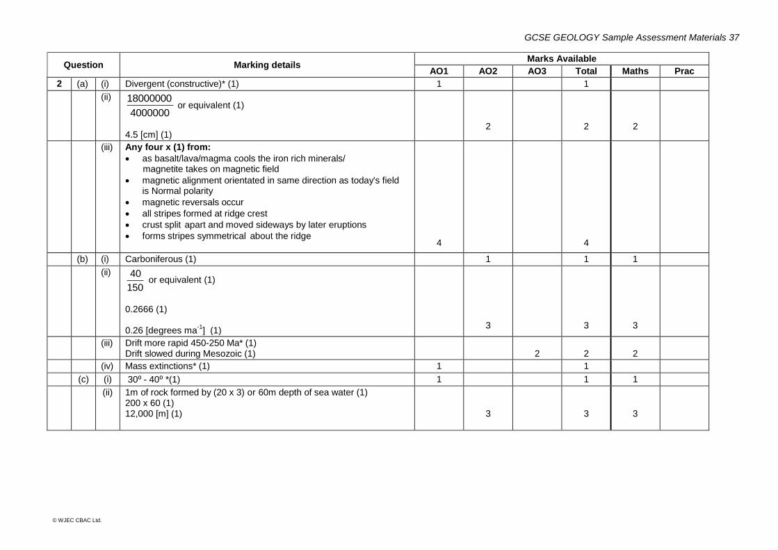
GCSE GEOLOGY Sample Assessment Materials 37
© WJEC CBAC Ltd.
Question Marking details Marks Available
AO1 AO2 AO3 Total Maths Prac
2 (a) (i) Divergent (constructive)* (1) 1 1
(ii)
4000000
18000000 or equivalent (1)
4.5 [cm] (1)
2
2
2
(iii) Any four x (1) from:
as basalt/lava/magma cools the iron rich minerals/ magnetite takes on magnetic field
magnetic alignment orientated in same direction as today's field is Normal polarity
magnetic reversals occur
all stripes formed at ridge crest
crust split apart and moved sideways by later eruptions
forms stripes symmetrical about the ridge
4
4
(b) (i) Carboniferous (1) 1 1 1
(ii)
150
40 or equivalent (1)
0.2666 (1) 0.26 [degrees ma
-1] (1)
3
3
3
(iii) Drift more rapid 450-250 Ma* (1) Drift slowed during Mesozoic (1)
2
2
2
(iv) Mass extinctions* (1) 1 1
(c) (i) 30⁰ - 40⁰ *(1) 1 1 1
(ii) 1m of rock formed by (20 x 3) or 60m depth of sea water (1) 200 x 60 (1) 12,000 [m] (1)
3
3
3
GCSE GEOLOGY Sample Assessment Materials 38
© WJEC CBAC Ltd.
Question Marking details Marks Available
AO1 AO2 AO3 Total Maths Prac
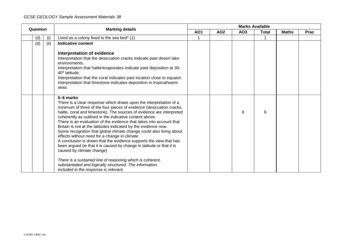
(d) (i) Lived as a colony fixed to the sea bed* (1) 1 1
(d) (ii) Indicative content
Interpretation of evidence Interpretation that the desiccation cracks indicate past desert lake environments. Interpretation that halite/evaporates indicate past deposition at 30-
40⁰ latitude.
Interpretation that the coral indicates past location close to equator. Interpretation that limestone indicates deposition in tropical/warm seas.
5–6 marks There is a clear response which draws upon the interpretation of a minimum of three of the four pieces of evidence (desiccation cracks, halite, coral and limestone). The sources of evidence are interpreted coherently as outlined in the indicative content above. There is an evaluation of the evidence that takes into account that Britain is not at the latitudes indicated by the evidence now. Some recognition that global climate change could also bring about effects without need for a change in climate A conclusion is drawn that the evidence supports the view that has been argued (ie that it is caused by change in latitude or that it is caused by climate change) There is a sustained line of reasoning which is coherent, substantiated and logically structured. The information included in the response is relevant.
6
6
GCSE GEOLOGY Sample Assessment Materials 39
© WJEC CBAC Ltd.
Question Marking details Marks Available
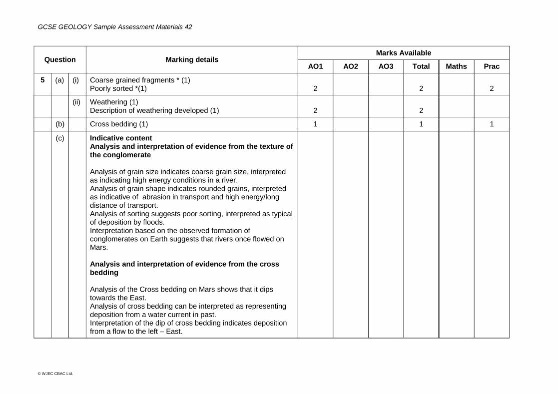
AO1 AO2 AO3 Total Maths Prac
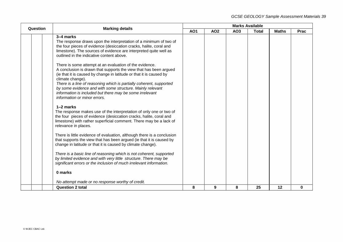
3–4 marks The response draws upon the interpretation of a minimum of two of the four pieces of evidence (desiccation cracks, halite, coral and limestone). The sources of evidence are interpreted quite well as outlined in the indicative content above. There is some attempt at an evaluation of the evidence. A conclusion is drawn that supports the view that has been argued (ie that it is caused by change in latitude or that it is caused by climate change). There is a line of reasoning which is partially coherent, supported by some evidence and with some structure. Mainly relevant information is included but there may be some irrelevant information or minor errors. 1–2 marks The response makes use of the interpretation of only one or two of the four pieces of evidence (desiccation cracks, halite, coral and limestone) with rather superficial comment. There may be a lack of relevance in places. There is little evidence of evaluation, although there is a conclusion that supports the view that has been argued (ie that it is caused by change in latitude or that it is caused by climate change). There is a basic line of reasoning which is not coherent, supported by limited evidence and with very little structure. There may be significant errors or the inclusion of much irrelevant information. 0 marks No attempt made or no response worthy of credit.
Question 2 total 8 9 8 25 12 0
GCSE GEOLOGY Sample Assessment Materials 40
© WJEC CBAC Ltd.
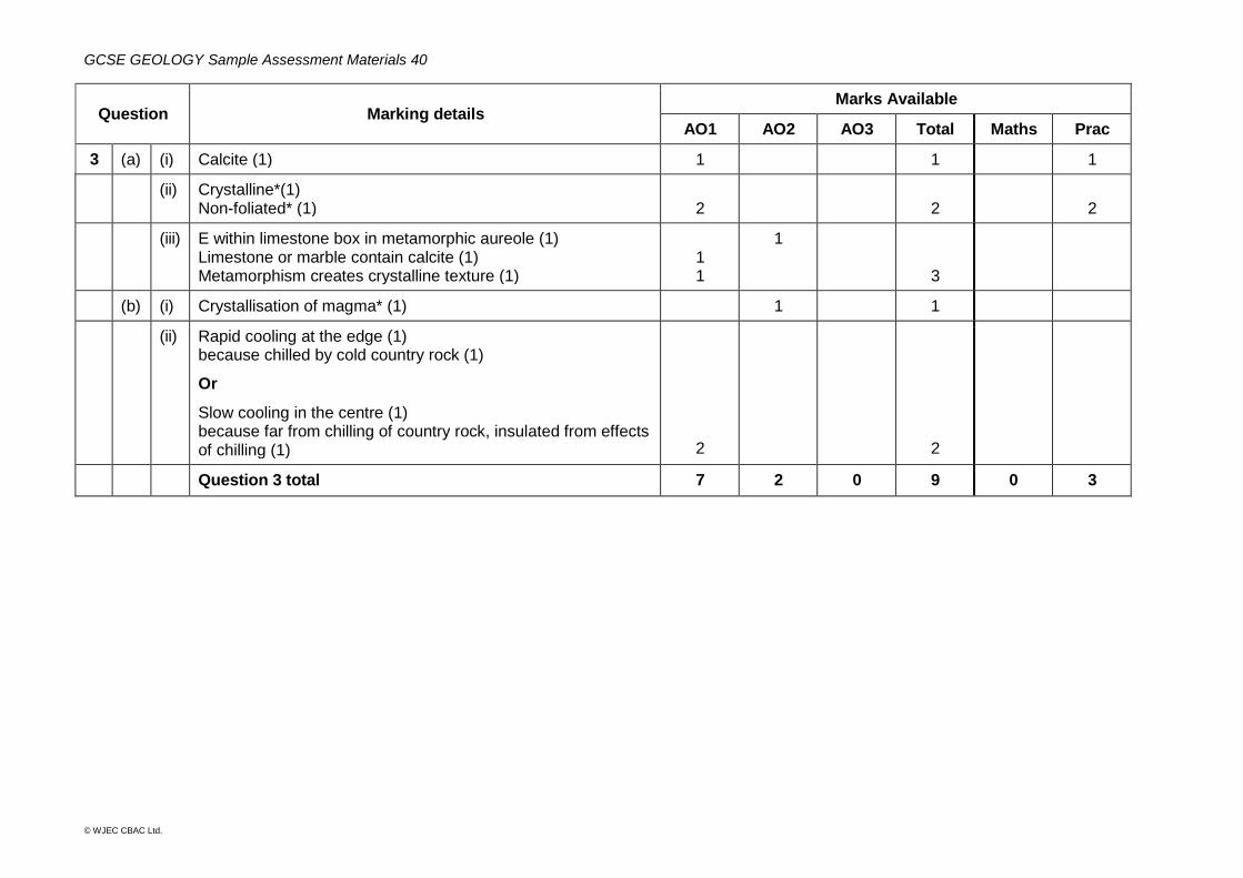
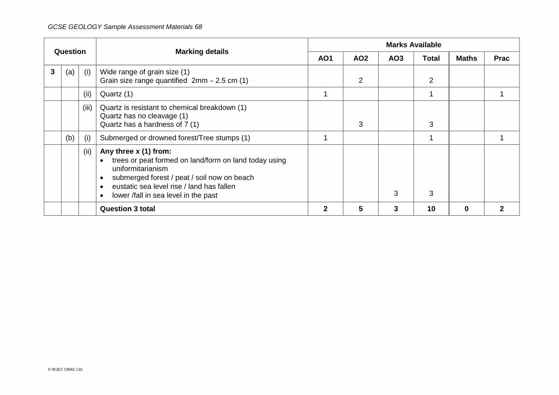
Question Marking details Marks Available
AO1 AO2 AO3 Total Maths Prac
3 (a) (i) Calcite (1) 1 1 1
(ii) Crystalline*(1) Non-foliated* (1)
2
2
2
(iii) E within limestone box in metamorphic aureole (1) Limestone or marble contain calcite (1) Metamorphism creates crystalline texture (1)
1 1
1
3
(b) (i) Crystallisation of magma* (1) 1 1
(ii) Rapid cooling at the edge (1) because chilled by cold country rock (1)
Or
Slow cooling in the centre (1) because far from chilling of country rock, insulated from effects of chilling (1)
2
2
Question 3 total 7 2 0 9 0 3
GCSE GEOLOGY Sample Assessment Materials 41
© WJEC CBAC Ltd.
Question Marking details Marks Available
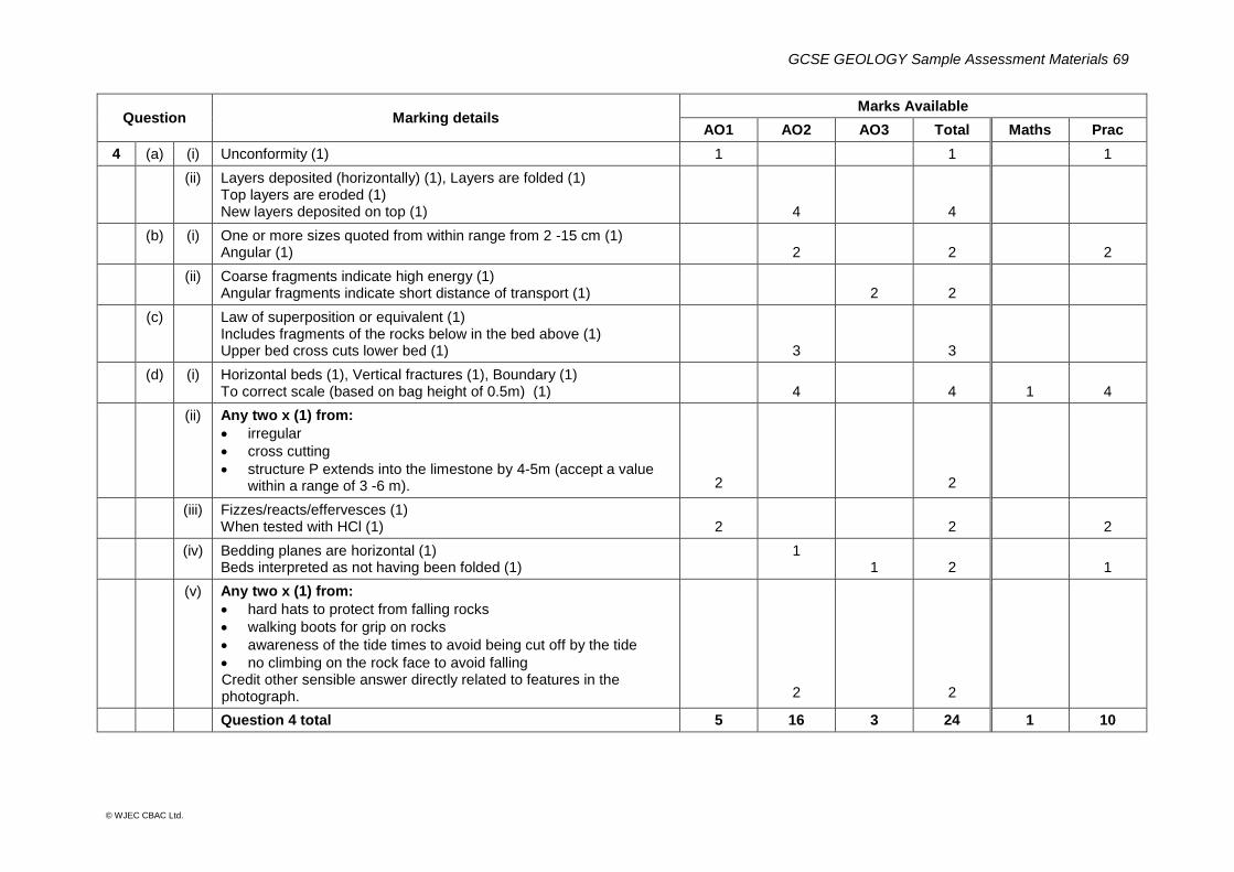
AO1 AO2 AO3 Total Maths Prac
4 (a) (i) Subduction* (1) 1 1
(ii) 2 hours (1) 1 1 1
(iii)
8
6000(1)
750 [km hr -1] (1)
2
2
2
(b) (i) Wave height only 0.5m or little change in height of sea surface as tsunami passes in deep water (1)
1
1
(ii) Any three x (1) from:
better warning system at sea
better evacuation procedures
warning notices on land
greater awareness and community preparedness
sea defences
tsunami resistant building design
building regulations/planning restrictions For each mark, the answer must provide a description of the point listed e.g. a brief description of a sea defence, a brief description of tsumani resistant building design.
3
3
Question 4 total 4 4 0 8 3 0
GCSE GEOLOGY Sample Assessment Materials 42
© WJEC CBAC Ltd.
Question Marking details Marks Available
AO1 AO2 AO3 Total Maths Prac
5 (a) (i) Coarse grained fragments * (1) Poorly sorted *(1)
2
2
2
(ii) Weathering (1) Description of weathering developed (1)
2
2
(b) Cross bedding (1) 1 1 1
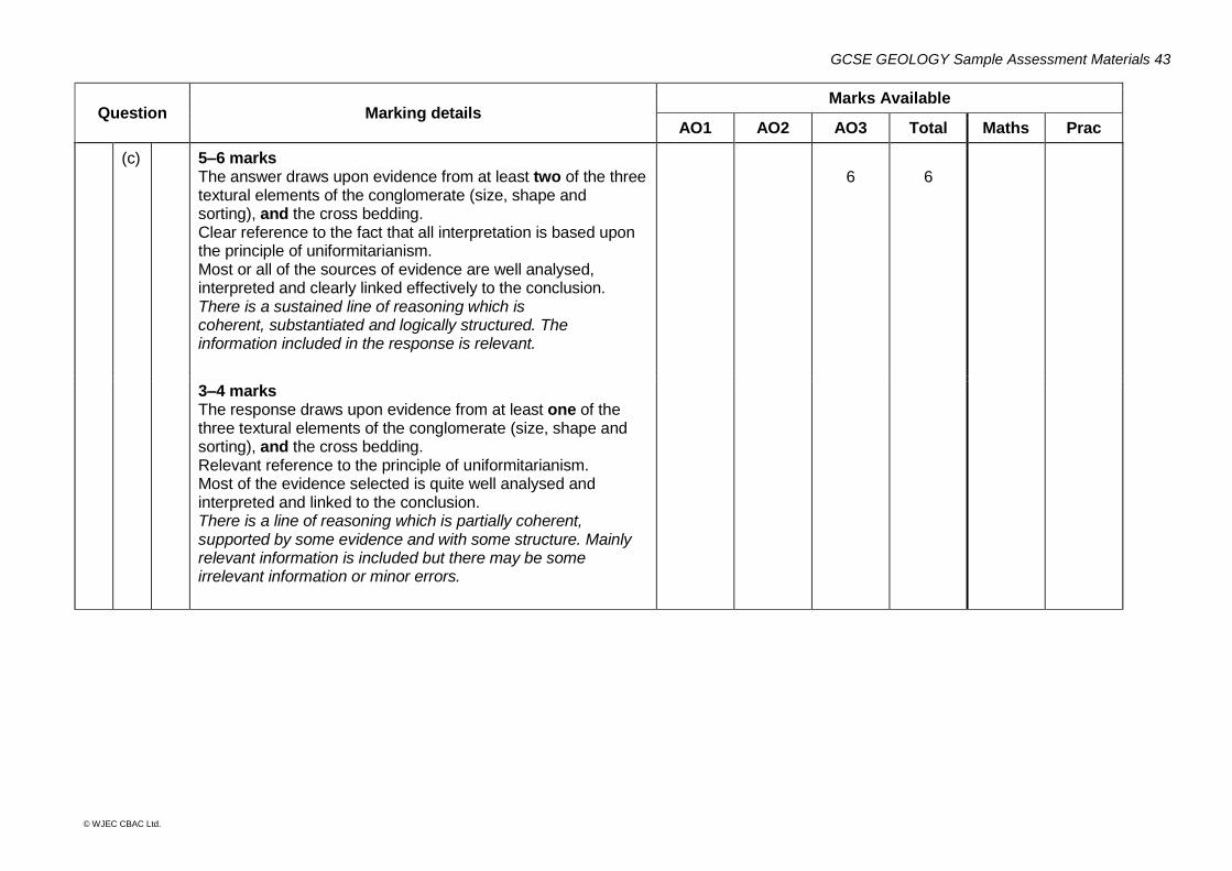
(c) Indicative content Analysis and interpretation of evidence from the texture of the conglomerate Analysis of grain size indicates coarse grain size, interpreted as indicating high energy conditions in a river. Analysis of grain shape indicates rounded grains, interpreted as indicative of abrasion in transport and high energy/long distance of transport. Analysis of sorting suggests poor sorting, interpreted as typical of deposition by floods. Interpretation based on the observed formation of conglomerates on Earth suggests that rivers once flowed on Mars. Analysis and interpretation of evidence from the cross bedding Analysis of the Cross bedding on Mars shows that it dips towards the East. Analysis of cross bedding can be interpreted as representing deposition from a water current in past. Interpretation of the dip of cross bedding indicates deposition from a flow to the left – East.
GCSE GEOLOGY Sample Assessment Materials 43
© WJEC CBAC Ltd.
Question Marking details Marks Available
AO1 AO2 AO3 Total Maths Prac
(c) 5–6 marks The answer draws upon evidence from at least two of the three textural elements of the conglomerate (size, shape and sorting), and the cross bedding. Clear reference to the fact that all interpretation is based upon the principle of uniformitarianism. Most or all of the sources of evidence are well analysed, interpreted and clearly linked effectively to the conclusion. There is a sustained line of reasoning which is coherent, substantiated and logically structured. The information included in the response is relevant.
6
6
3–4 marks The response draws upon evidence from at least one of the three textural elements of the conglomerate (size, shape and sorting), and the cross bedding. Relevant reference to the principle of uniformitarianism. Most of the evidence selected is quite well analysed and interpreted and linked to the conclusion. There is a line of reasoning which is partially coherent, supported by some evidence and with some structure. Mainly relevant information is included but there may be some irrelevant information or minor errors.
GCSE GEOLOGY Sample Assessment Materials 44
© WJEC CBAC Ltd.
Question Marking details Marks Available
AO1 AO2 AO3 Total Maths Prac
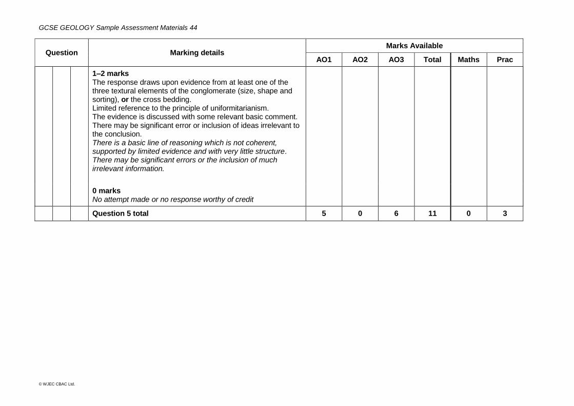
1–2 marks The response draws upon evidence from at least one of the three textural elements of the conglomerate (size, shape and sorting), or the cross bedding. Limited reference to the principle of uniformitarianism. The evidence is discussed with some relevant basic comment. There may be significant error or inclusion of ideas irrelevant to the conclusion. There is a basic line of reasoning which is not coherent, supported by limited evidence and with very little structure. There may be significant errors or the inclusion of much irrelevant information.
0 marks No attempt made or no response worthy of credit
Question 5 total 5 0 6 11 0 3
GCSE GEOLOGY Sample Assessment Materials 45
© WJEC CBAC Ltd.
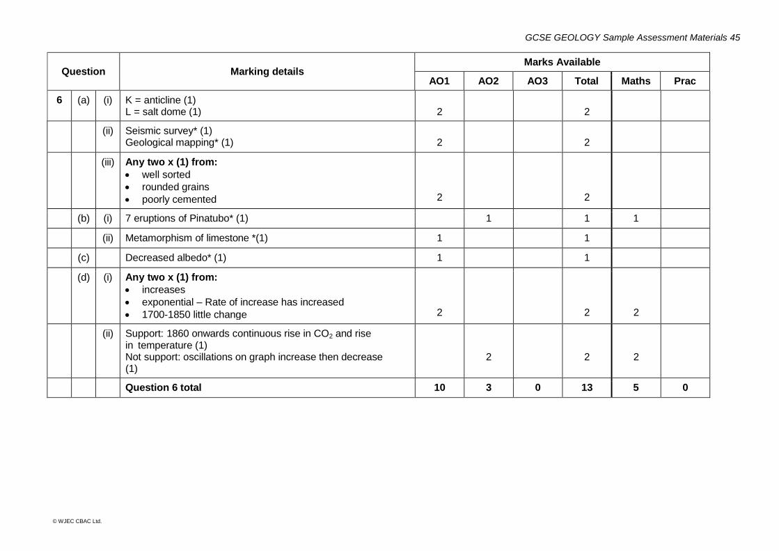
Question Marking details Marks Available
AO1 AO2 AO3 Total Maths Prac
6 (a) (i) K = anticline (1) L = salt dome (1)
2
2
(ii) Seismic survey* (1) Geological mapping* (1)
2
2
(iii) Any two x (1) from:
well sorted
rounded grains
poorly cemented
2
2
(b) (i) 7 eruptions of Pinatubo* (1) 1 1 1
(ii) Metamorphism of limestone *(1) 1 1
(c) Decreased albedo* (1) 1 1
(d) (i) Any two x (1) from:
increases
exponential – Rate of increase has increased
1700-1850 little change
2
2
2
(ii) Support: 1860 onwards continuous rise in CO2 and rise in temperature (1) Not support: oscillations on graph increase then decrease (1)
2
2
2
Question 6 total 10 3 0 13 5 0

GCSE GEOLOGY Sample Assessment Materials 47
© WJEC CBAC Ltd.
Candidate Name Centre Number Candidate Number
0
GCSE GEOLOGY COMPONENT 2 Investigative Geology SAMPLE ASSESSMENT MATERIALS (1 hour 30 minutes)
ADDITIONAL MATERIALS In addition to this examination paper you will need Map 1, the Data Sheet and a calculator. INSTRUCTIONS TO CANDIDATES Use black ink or black ball-point pen. Do not use gel pen. Do not use correction fluid. Write your name, centre number and candidate number in the spaces at the top of this page. Answer all questions. Write your answers in the spaces provided in this booklet. INFORMATION FOR CANDIDATES The number of marks is given in brackets at the end of each question or part-question. The assessment of the quality of extended response (QER) will take place in question 6.
Examiner’s use only
Question Maximum
Mark Mark
Awarded
1. 12
2. 9
3. 10
4. 24
5. 13
6. 12
Total 80
GCSE GEOLOGY Sample Assessment Materials 48
© WJEC CBAC Ltd.
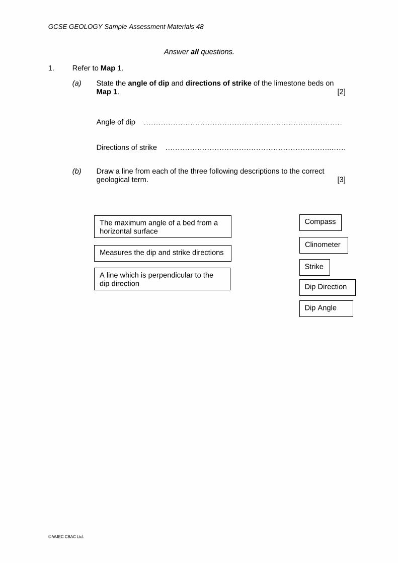
The maximum angle of a bed from a horizontal surface
Measures the dip and strike directions
A line which is perpendicular to the dip direction
Compass
Clinometer
Strike
Dip Direction
Dip Angle
Answer all questions.
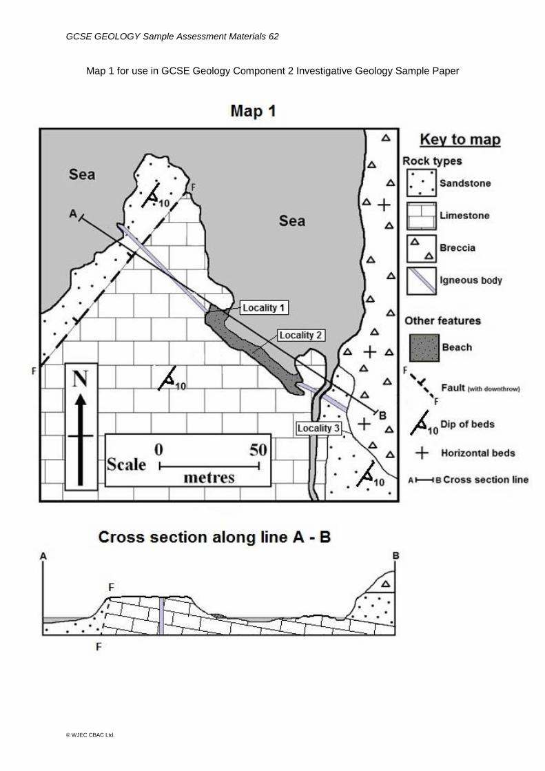
1. Refer to Map 1.
(a) State the angle of dip and directions of strike of the limestone beds on Map 1. [2]
Angle of dip ……………………………………………………………………… Directions of strike …………………………………………………………..……
(b) Draw a line from each of the three following descriptions to the correct geological term. [3]
GCSE GEOLOGY Sample Assessment Materials 49
© WJEC CBAC Ltd.
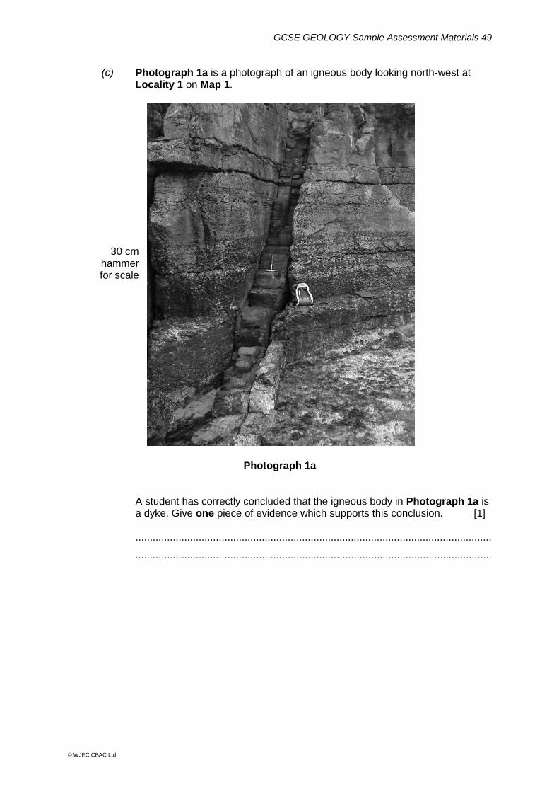
(c) Photograph 1a is a photograph of an igneous body looking north-west at Locality 1 on Map 1.
30 cm hammer for scale
Photograph 1a
A student has correctly concluded that the igneous body in Photograph 1a is a dyke. Give one piece of evidence which supports this conclusion. [1]
............................................................................................................................
............................................................................................................................
GCSE GEOLOGY Sample Assessment Materials 50
© WJEC CBAC Ltd.
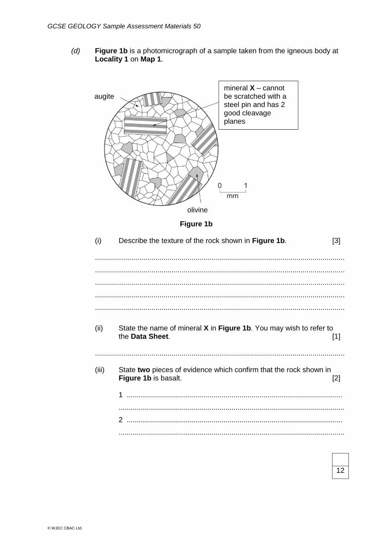
(d) Figure 1b is a photomicrograph of a sample taken from the igneous body at Locality 1 on Map 1.
Figure 1b
(i) Describe the texture of the rock shown in Figure 1b. [3] ............................................................................................................................
............................................................................................................................
............................................................................................................................
............................................................................................................................
............................................................................................................................
(ii) State the name of mineral X in Figure 1b. You may wish to refer to the Data Sheet. [1] ............................................................................................................................ (iii) State two pieces of evidence which confirm that the rock shown in Figure 1b is basalt. [2] 1 ...........................................................................................................
................................................................................................................
2 ...........................................................................................................
................................................................................................................
12
augite
olivine
mineral X – cannot be scratched with a steel pin and has 2 good cleavage planes
GCSE GEOLOGY Sample Assessment Materials 51
© WJEC CBAC Ltd.
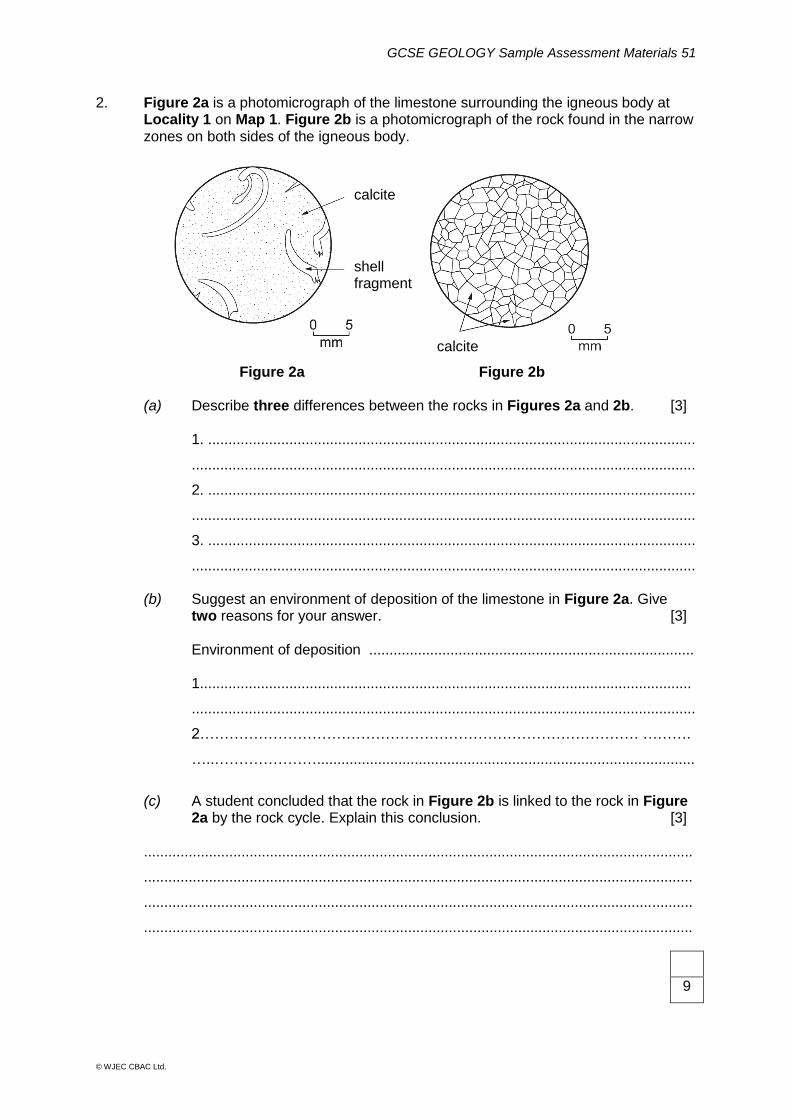
2. Figure 2a is a photomicrograph of the limestone surrounding the igneous body at Locality 1 on Map 1. Figure 2b is a photomicrograph of the rock found in the narrow zones on both sides of the igneous body.
Figure 2a Figure 2b (a) Describe three differences between the rocks in Figures 2a and 2b. [3] 1. ........................................................................................................................
............................................................................................................................
2. ........................................................................................................................
............................................................................................................................
3. ........................................................................................................................
............................................................................................................................
(b) Suggest an environment of deposition of the limestone in Figure 2a. Give two reasons for your answer. [3]
Environment of deposition ................................................................................ 1.........................................................................................................................
............................................................................................................................
2……………………………………………………………………………… ……….
…..………………….............................................................................................
(c) A student concluded that the rock in Figure 2b is linked to the rock in Figure 2a by the rock cycle. Explain this conclusion. [3] .......................................................................................................................................
.......................................................................................................................................
.......................................................................................................................................
.......................................................................................................................................
9
calcite
calcite
shell fragments
GCSE GEOLOGY Sample Assessment Materials 52
© WJEC CBAC Ltd.
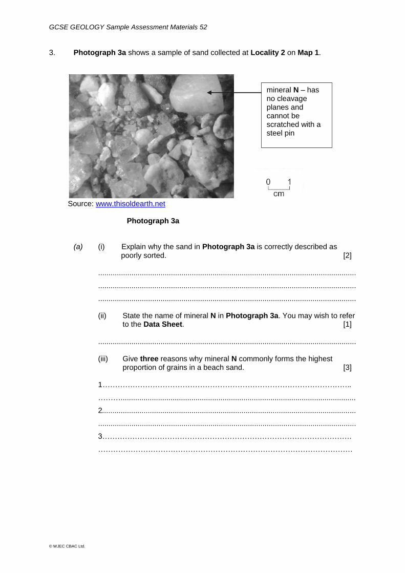
3. Photograph 3a shows a sample of sand collected at Locality 2 on Map 1.
Source: www.thisoldearth.net
Photograph 3a
(a) (i) Explain why the sand in Photograph 3a is correctly described as poorly sorted. [2]
............................................................................................................................
............................................................................................................................
............................................................................................................................
(ii) State the name of mineral N in Photograph 3a. You may wish to refer to the Data Sheet. [1]
............................................................................................................................
(iii) Give three reasons why mineral N commonly forms the highest proportion of grains in a beach sand. [3]
1……………………………………………………………………………………….
……….................................................................................................................
2..........................................................................................................................
............................................................................................................................
3……………………………………………………………………………………….
…………………………………………………………………………………………
mineral N – has no cleavage planes and cannot be scratched with a steel pin
GCSE GEOLOGY Sample Assessment Materials 53
© WJEC CBAC Ltd.
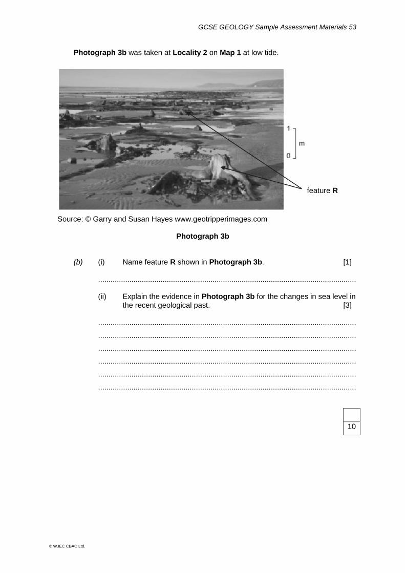
Photograph 3b was taken at Locality 2 on Map 1 at low tide.
Source: © Garry and Susan Hayes www.geotripperimages.com
Photograph 3b
(b) (i) Name feature R shown in Photograph 3b. [1] ............................................................................................................................ (ii) Explain the evidence in Photograph 3b for the changes in sea level in the recent geological past. [3] ............................................................................................................................
............................................................................................................................
............................................................................................................................
............................................................................................................................
............................................................................................................................
............................................................................................................................
10
feature R
GCSE GEOLOGY Sample Assessment Materials 54
© WJEC CBAC Ltd.
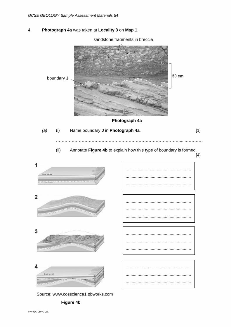
4. Photograph 4a was taken at Locality 3 on Map 1.
Photograph 4a (a) (i) Name boundary J in Photograph 4a. [1] …………………………………………………………………………….....………… (ii) Annotate Figure 4b to explain how this type of boundary is formed. [4]
.......................................................
.......................................................
.......................................................
.
.......................................................
.......................................................
.......................................................
.
.......................................................
.......................................................
.......................................................
.
.......................................................
.......................................................
.......................................................
.
Figure 4b
sandstone fragments in breccia
boundary J
Source: www.cosscience1.pbworks.com
GCSE GEOLOGY Sample Assessment Materials 55
© WJEC CBAC Ltd.
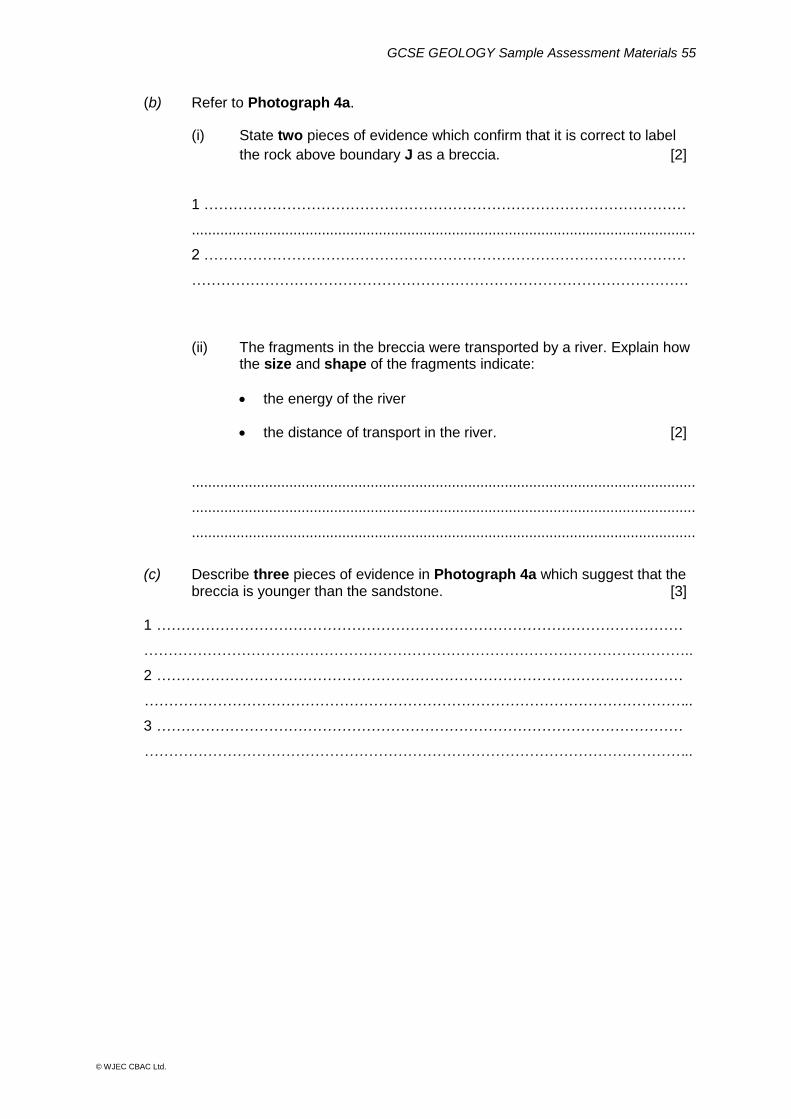
(b) Refer to Photograph 4a.
(i) State two pieces of evidence which confirm that it is correct to label
the rock above boundary J as a breccia. [2]
1 ………………………………………………………………………………………
............................................................................................................................
2 ………………………………………………………………………………………
…………………………………………………………………………………………
(ii) The fragments in the breccia were transported by a river. Explain how the size and shape of the fragments indicate:
the energy of the river
the distance of transport in the river. [2]
............................................................................................................................
............................................................................................................................
............................................................................................................................
(c) Describe three pieces of evidence in Photograph 4a which suggest that the breccia is younger than the sandstone. [3] 1 ………………………………………………………………………………………………
…………………………………………………………………………………………………..
2 ………………………………………………………………………………………………
…………………………………………………………………………………………………..
3 ………………………………………………………………………………………………
…………………………………………………………………………………………………..
GCSE GEOLOGY Sample Assessment Materials 56
© WJEC CBAC Ltd.
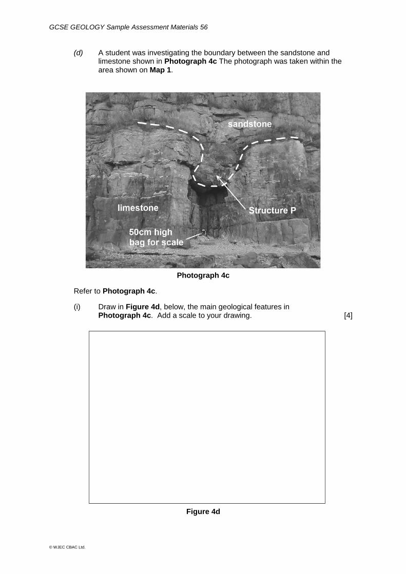
(d) A student was investigating the boundary between the sandstone and limestone shown in Photograph 4c The photograph was taken within the area shown on Map 1.
Photograph 4c
Refer to Photograph 4c.
(i) Draw in Figure 4d, below, the main geological features in Photograph 4c. Add a scale to your drawing. [4]
Figure 4d
GCSE GEOLOGY Sample Assessment Materials 57
© WJEC CBAC Ltd.
(ii) Describe the boundary shown by the dashed line in Photograph 4c. [2]
............................................................................................................................
............................................................................................................................
(iii) Describe how the student could confirm that the lower rock is limestone. [2] ...........................................................................................................................
...........................................................................................................................
(iv) State and explain the evidence that structure P is not a synform. [2] ............................................................................................................................
............................................................................................................................
............................................................................................................................
(v) State two safety precautions that the student should take when
visiting the site shown in Photograph 4c. Describe why each is important. [2]
1 ........................................................................................................................
………................................................................................................................
2 ........................................................................................................................
………................................................................................................................
24
GCSE GEOLOGY Sample Assessment Materials 58
© WJEC CBAC Ltd.
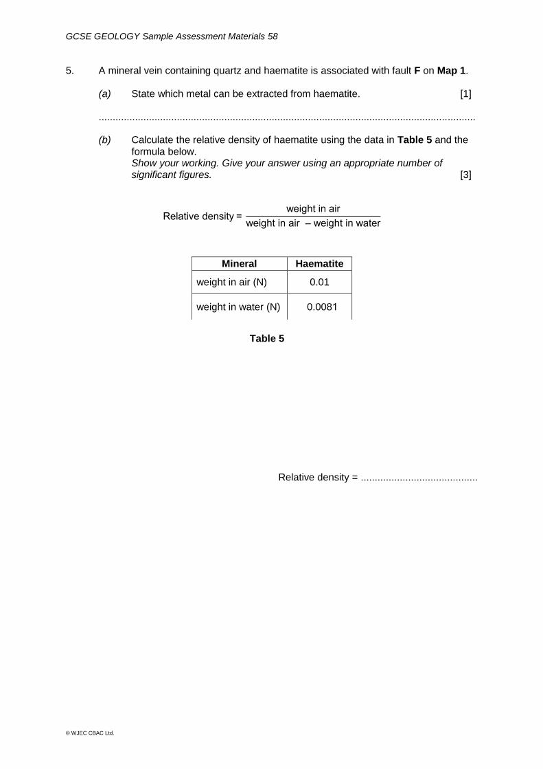
5. A mineral vein containing quartz and haematite is associated with fault F on Map 1.
(a) State which metal can be extracted from haematite. [1]
.......................................................................................................................................
(b) Calculate the relative density of haematite using the data in Table 5 and the formula below. Show your working. Give your answer using an appropriate number of significant figures. [3]
Relative density = weight in air
weight in air ‒ weight in water
Table 5
Relative density = ..........................................
Mineral Haematite
weight in air (N) 0.01
weight in water (N) 0.0081
GCSE GEOLOGY Sample Assessment Materials 59
© WJEC CBAC Ltd.
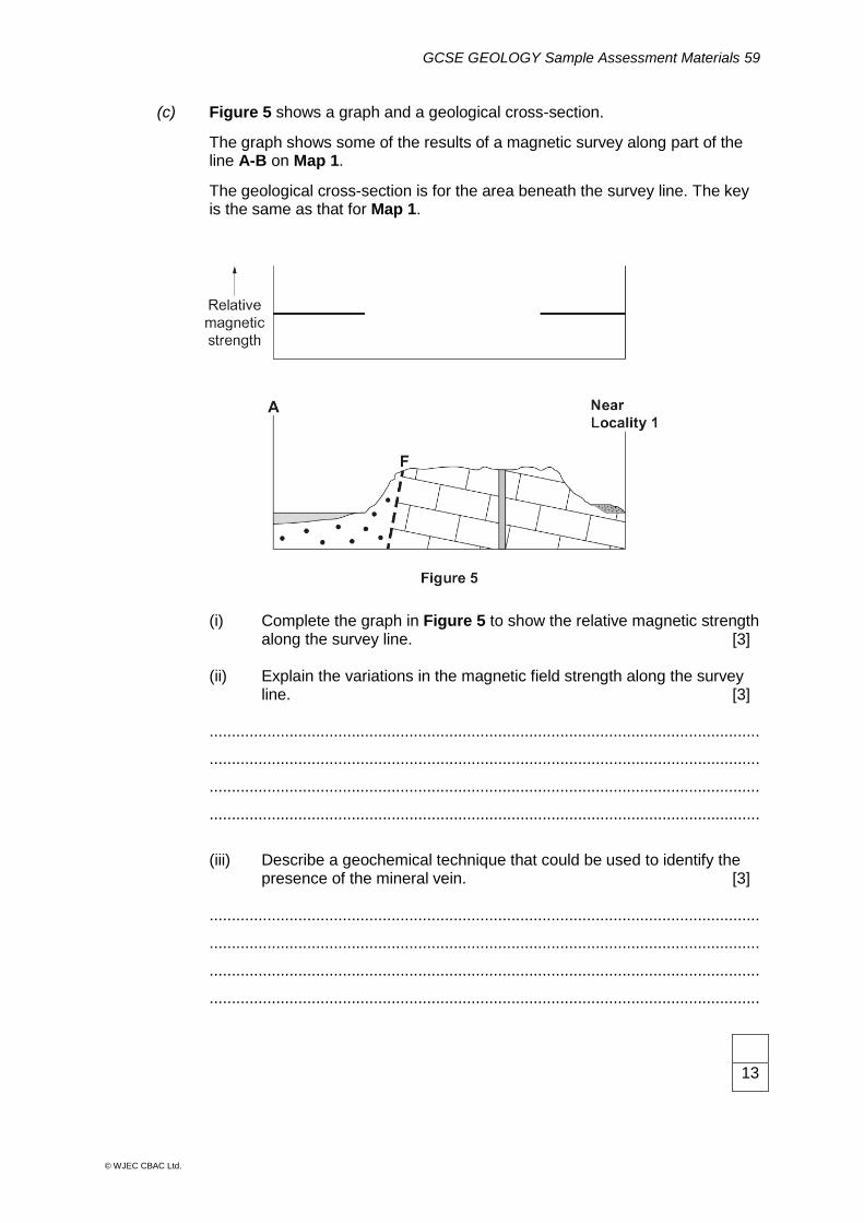
(c) Figure 5 shows a graph and a geological cross-section.
The graph shows some of the results of a magnetic survey along part of the line A-B on Map 1.
The geological cross-section is for the area beneath the survey line. The key is the same as that for Map 1.
(i) Complete the graph in Figure 5 to show the relative magnetic strength along the survey line. [3]
(ii) Explain the variations in the magnetic field strength along the survey line. [3] ............................................................................................................................
............................................................................................................................
............................................................................................................................
............................................................................................................................
(iii) Describe a geochemical technique that could be used to identify the presence of the mineral vein. [3] ............................................................................................................................
............................................................................................................................
............................................................................................................................
............................................................................................................................
13
GCSE GEOLOGY Sample Assessment Materials 60
© WJEC CBAC Ltd.
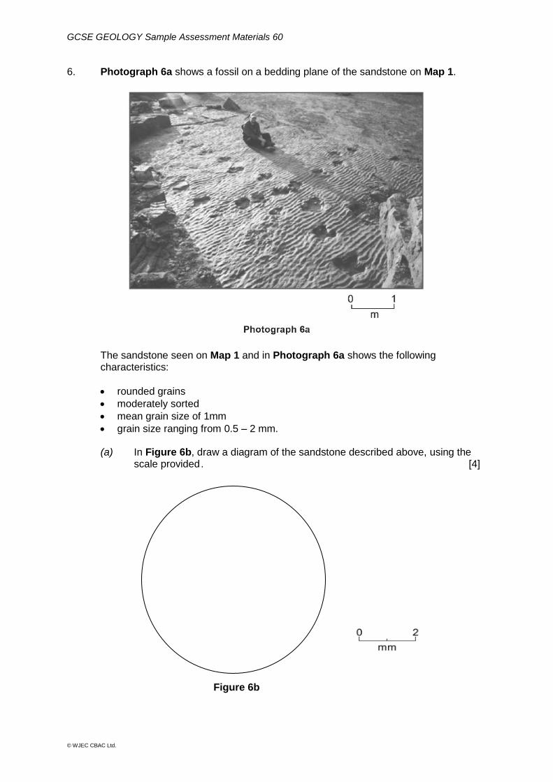
6. Photograph 6a shows a fossil on a bedding plane of the sandstone on Map 1.
The sandstone seen on Map 1 and in Photograph 6a shows the following characteristics:
rounded grains
moderately sorted
mean grain size of 1mm
grain size ranging from 0.5 – 2 mm. (a) In Figure 6b, draw a diagram of the sandstone described above, using the scale provided . [4]
Figure 6b
GCSE GEOLOGY Sample Assessment Materials 61
© WJEC CBAC Ltd.
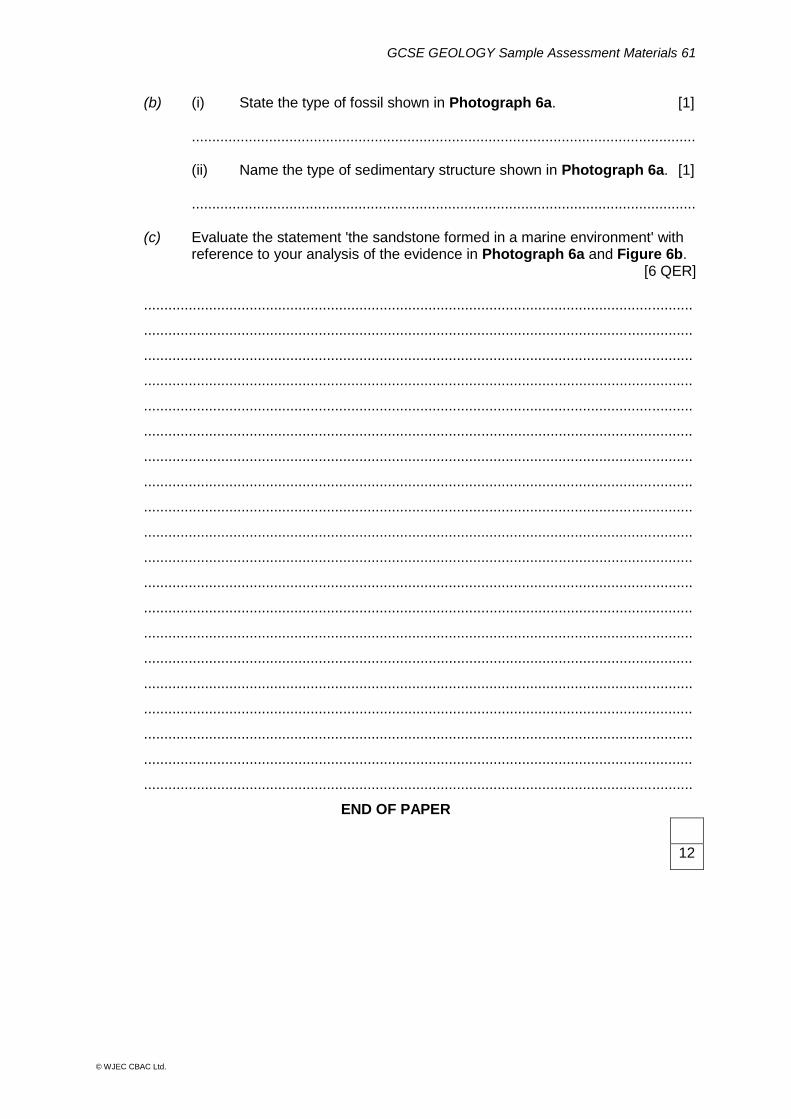
(b) (i) State the type of fossil shown in Photograph 6a. [1] ............................................................................................................................ (ii) Name the type of sedimentary structure shown in Photograph 6a. [1] ............................................................................................................................
(c) Evaluate the statement 'the sandstone formed in a marine environment' with reference to your analysis of the evidence in Photograph 6a and Figure 6b.
[6 QER] .......................................................................................................................................
.......................................................................................................................................
.......................................................................................................................................
.......................................................................................................................................
.......................................................................................................................................
.......................................................................................................................................
.......................................................................................................................................
.......................................................................................................................................
.......................................................................................................................................
.......................................................................................................................................
.......................................................................................................................................
.......................................................................................................................................
.......................................................................................................................................
.......................................................................................................................................
.......................................................................................................................................
.......................................................................................................................................
.......................................................................................................................................
.......................................................................................................................................
.......................................................................................................................................
.......................................................................................................................................
END OF PAPER
12
GCSE GEOLOGY Sample Assessment Materials 62
© WJEC CBAC Ltd.
Map 1 for use in GCSE Geology Component 2 Investigative Geology Sample Paper
GCSE GEOLOGY Sample Assessment Materials 63
© WJEC CBAC Ltd.
WJEC Eduqas GCSE Geology
Marking scheme for use with Component 2
Investigative Geology
SAMPLE ASSESSMENT MATERIALS
GCSE GEOLOGY Sample Assessment Materials 64
© WJEC CBAC Ltd.
Instructions for examiners of GCSE Geology when applying the marking scheme 1 Positive marking
It should be remembered that candidates are writing under examination conditions and credit should be given for what the candidate writes, rather than adopting the approach of penalising him/her for any omissions. It should be possible for a very good response to achieve full marks and a very poor one to achieve zero marks. Worthwhile answers that meet the requirements of the question, but do not appear on the mark scheme are to be given credit.
2 Tick marking
Low tariff questions should be marked using a points-based system. Each credit worthy response should be ticked in red pen. The number of ticks must equal the mark awarded for the sub-question. The mark scheme should be applied precisely using the marking details box as a guide to the responses that are acceptable. Do not use crosses to indicate answers that are incorrect.
3 Banded mark schemes
Banded mark schemes are divided so that each band has a relevant descriptor. The descriptor for the band provides a description of the performance level for that band. Each band contains marks. Examiners should first read and annotate a learner’s answer to pick out the evidence that is being assessed in that question. Do not use ticks on the candidate’s response. Once the annotation is complete, the mark scheme can be applied. This is done as a two stage process.
GCSE GEOLOGY Sample Assessment Materials 65
© WJEC CBAC Ltd.
Stage 1 – Deciding on the band When deciding on a band, the answer should be viewed holistically. Beginning at the lowest band, examiners should look at the learner’s answer and check whether it matches the descriptor for that band. Examiners should look at the descriptor for that band and see if it matches the qualities shown in the learner’s answer. If the descriptor at the lowest band is satisfied, examiners should move up to the next band and repeat this process for each band until the descriptor matches the answer. If an answer covers different aspects of different bands within the mark scheme, a ‘best fit’ approach should be adopted to decide on the band and then the learner’s response should be used to decide on the mark within the band. For instance if a response is mainly in band 2 but with a limited amount of band 3 content, the answer would be placed in band 2, but the mark awarded would be close to the top of band 2 as a result of the band 3 content. Examiners should not seek to mark candidates down as a result of small omissions in minor areas of an answer. Stage 2 – Deciding on the mark Once the band has been decided, examiners can then assign a mark. During standardising (marking conference), detailed advice from the Principal Examiner on the qualities of each mark band will be given. Examiners will then receive examples of answers in each mark band that have been awarded a mark by the Principal Examiner. Examiners should mark the examples and compare their marks with those of the Principal Examiner. When marking, examiners can use these examples to decide whether a learner’s response is of a superior, inferior or comparable standard to the example. Examiners are reminded of the need to revisit the answer as they apply the mark scheme in order to confirm that the band and the mark allocated is appropriate to the response provided. Indicative content is also provided for banded mark schemes. Indicative content is not exhaustive, and any other valid points must be credited. In order to reach the highest bands of the mark scheme a learner need not cover all of the points mentioned in the indicative content but must meet the requirements of the highest mark band. Where a response is not creditworthy, that is contains nothing of any significance to the mark scheme, or where no response has been provided, no marks should be awarded.
GCSE GEOLOGY Sample Assessment Materials 66
© WJEC CBAC Ltd.
Question Marking details Marks Available
AO1 AO2 AO3 Total Maths Prac
1 (a) Angle of dip = 10⁰ (1) Directions of strike = NE/SW (1)
2
2
(b) The maximum angle of a bed from a horizontal surface = dip angle (1) Measures the dip and strike directions = compass (1) A line which is perpendicular to the dip direction = strike (1)
3
3
3
(c) Discordant (or equivalent) (1) 1 1 1
(d) (i) Any three x (1) from:
crystalline or interlocking crystals
fine crystals or size stated of groundmass (between 0.5 – 1
mm) or size of phenocrysts stated (2 mm)
larger crystals / phenocrysts / porphyritic
smaller groundmass
random crystals
3
3
3
(ii) Feldspar (1) 1 1
1
(iii) Fine crystal size (1) Contains mafic minerals/olivine/augite (1)
2
2
Question 1 total 10 2 0 12 0 8
GCSE GEOLOGY Sample Assessment Materials 67
© WJEC CBAC Ltd.
Question Marking details Marks Available
AO1 AO2 AO3 Total Maths Prac
2 (a) Any three x (1) from:
2b crystalline / 2a not crystalline
2a is limestone / 2b is marble
2a is finer / 2b is coarser
2a has fossils / 2b lack of fossils
3
3
3
(b) Environment: shallow marine (1) plus any 2 x (1) from:
limestone forms in shallow marine conditions today (1)
shells (or shell fagments) only form in shallow marine conditions today (1)
shells broken by waves (1)
3
3
(c) Recrystallisation (1) Limestone changes to marble (1) By contact or thermal metamorphism (1)
3
3
Question 2 total 3 0 6 9 0 3
GCSE GEOLOGY Sample Assessment Materials 68
© WJEC CBAC Ltd.
Question Marking details Marks Available
AO1 AO2 AO3 Total Maths Prac
3 (a) (i) Wide range of grain size (1)
Grain size range quantified 2mm – 2.5 cm (1)
2
2
(ii) Quartz (1) 1 1 1
(iii) Quartz is resistant to chemical breakdown (1) Quartz has no cleavage (1) Quartz has a hardness of 7 (1)
3
3
(b) (i) Submerged or drowned forest/Tree stumps (1) 1 1 1
(ii) Any three x (1) from:
trees or peat formed on land/form on land today using uniformitarianism
submerged forest / peat / soil now on beach
eustatic sea level rise / land has fallen
lower /fall in sea level in the past
3
3
Question 3 total 2 5 3 10 0 2
GCSE GEOLOGY Sample Assessment Materials 69
© WJEC CBAC Ltd.
Question Marking details Marks Available
AO1 AO2 AO3 Total Maths Prac
4 (a) (i) Unconformity (1) 1 1 1
(ii) Layers deposited (horizontally) (1), Layers are folded (1) Top layers are eroded (1) New layers deposited on top (1)
4
4
(b) (i) One or more sizes quoted from within range from 2 -15 cm (1) Angular (1)
2
2
2
(ii) Coarse fragments indicate high energy (1) Angular fragments indicate short distance of transport (1)
2
2
(c) Law of superposition or equivalent (1) Includes fragments of the rocks below in the bed above (1) Upper bed cross cuts lower bed (1)
3
3
(d) (i) Horizontal beds (1), Vertical fractures (1), Boundary (1) To correct scale (based on bag height of 0.5m) (1)
4
4
1
4
(ii) Any two x (1) from:
irregular
cross cutting
structure P extends into the limestone by 4-5m (accept a value within a range of 3 -6 m).
2
2
(iii) Fizzes/reacts/effervesces (1) When tested with HCl (1)
2
2
2
(iv) Bedding planes are horizontal (1) Beds interpreted as not having been folded (1)
1 1
2
1
(v) Any two x (1) from:
hard hats to protect from falling rocks
walking boots for grip on rocks
awareness of the tide times to avoid being cut off by the tide
no climbing on the rock face to avoid falling Credit other sensible answer directly related to features in the photograph.
2
2
Question 4 total 5 16 3 24 1 10
GCSE GEOLOGY Sample Assessment Materials 70
© WJEC CBAC Ltd.
Question Marking details Marks Available
AO1 AO2 AO3 Total Maths Prac
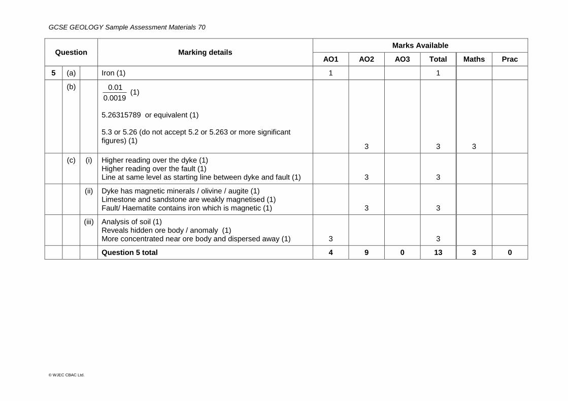
5 (a) Iron (1) 1 1
(b)
0.0019
0.01 (1)
5.26315789 or equivalent (1) 5.3 or 5.26 (do not accept 5.2 or 5.263 or more significant figures) (1)
3
3
3
(c) (i) Higher reading over the dyke (1) Higher reading over the fault (1) Line at same level as starting line between dyke and fault (1)
3
3
(ii) Dyke has magnetic minerals / olivine / augite (1) Limestone and sandstone are weakly magnetised (1) Fault/ Haematite contains iron which is magnetic (1)
3
3
(iii) Analysis of soil (1) Reveals hidden ore body / anomaly (1) More concentrated near ore body and dispersed away (1)
3
3
Question 5 total 4 9 0 13 3 0
GCSE GEOLOGY Sample Assessment Materials 71
© WJEC CBAC Ltd.
Question Marking details Marks Available
AO1 AO2 AO3 Total Maths Prac
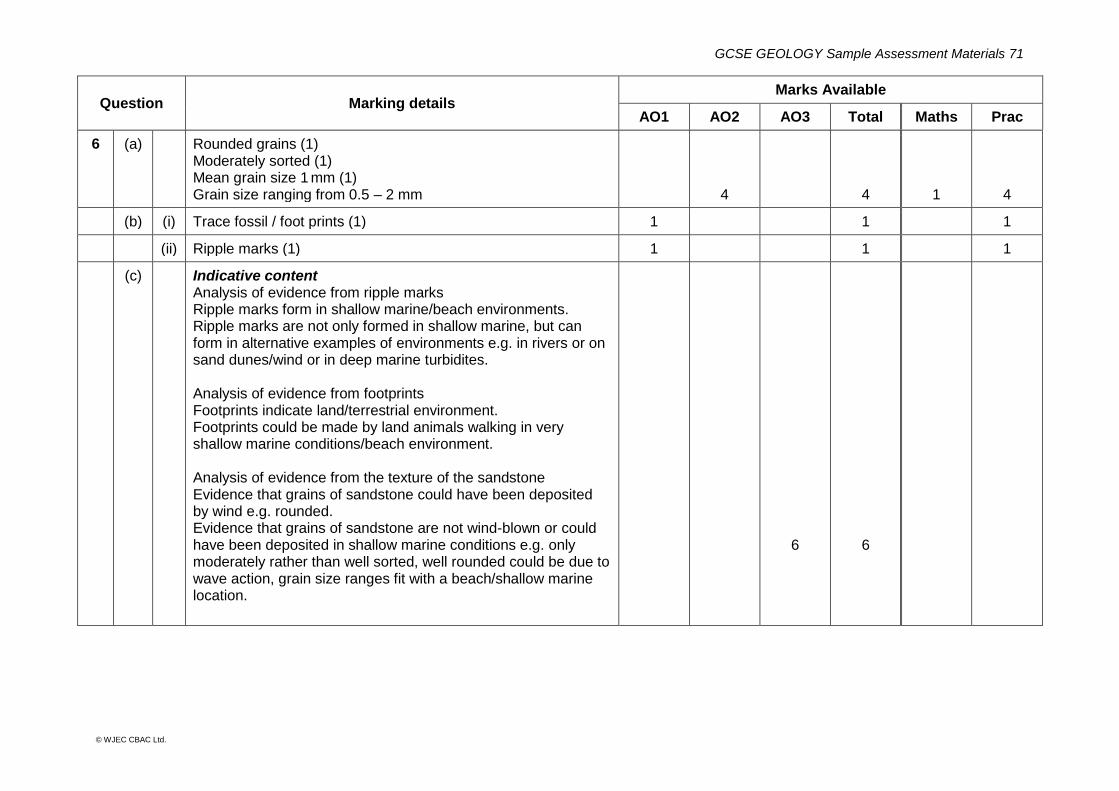
6 (a) Rounded grains (1) Moderately sorted (1) Mean grain size 1 mm (1) Grain size ranging from 0.5 – 2 mm
4
4
1
4
(b) (i) Trace fossil / foot prints (1) 1 1 1
(ii) Ripple marks (1) 1 1 1
(c) Indicative content Analysis of evidence from ripple marks Ripple marks form in shallow marine/beach environments. Ripple marks are not only formed in shallow marine, but can form in alternative examples of environments e.g. in rivers or on sand dunes/wind or in deep marine turbidites. Analysis of evidence from footprints Footprints indicate land/terrestrial environment. Footprints could be made by land animals walking in very shallow marine conditions/beach environment. Analysis of evidence from the texture of the sandstone Evidence that grains of sandstone could have been deposited by wind e.g. rounded. Evidence that grains of sandstone are not wind-blown or could have been deposited in shallow marine conditions e.g. only moderately rather than well sorted, well rounded could be due to wave action, grain size ranges fit with a beach/shallow marine location.
6
6
GCSE GEOLOGY Sample Assessment Materials 72
© WJEC CBAC Ltd.
Question Marking details Marks Available
AO1 AO2 AO3 Total Maths Prac
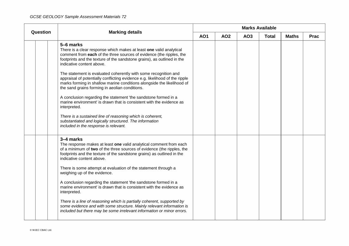
5–6 marks There is a clear response which makes at least one valid analytical comment from each of the three sources of evidence (the ripples, the footprints and the texture of the sandstone grains), as outlined in the indicative content above. The statement is evaluated coherently with some recognition and appraisal of potentially conflicting evidence e.g. likelihood of the ripple marks forming in shallow marine conditions alongside the likelihood of the sand grains forming in aeolian conditions. A conclusion regarding the statement 'the sandstone formed in a marine environment' is drawn that is consistent with the evidence as interpreted. There is a sustained line of reasoning which is coherent, substantiated and logically structured. The information included in the response is relevant.
3–4 marks The response makes at least one valid analytical comment from each of a minimum of two of the three sources of evidence (the ripples, the footprints and the texture of the sandstone grains) as outlined in the indicative content above. There is some attempt at evaluation of the statement through a weighing up of the evidence. A conclusion regarding the statement 'the sandstone formed in a marine environment' is drawn that is consistent with the evidence as interpreted. There is a line of reasoning which is partially coherent, supported by some evidence and with some structure. Mainly relevant information is included but there may be some irrelevant information or minor errors.
GCSE GEOLOGY Sample Assessment Materials 73
© WJEC CBAC Ltd.
Question Marking details Marks Available
AO1 AO2 AO3 Total Maths Prac
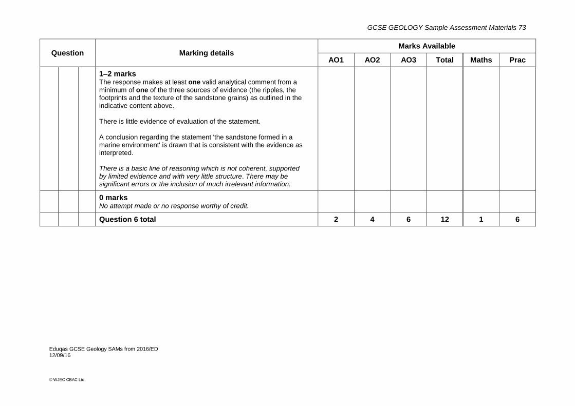
1–2 marks The response makes at least one valid analytical comment from a minimum of one of the three sources of evidence (the ripples, the footprints and the texture of the sandstone grains) as outlined in the indicative content above. There is little evidence of evaluation of the statement. A conclusion regarding the statement 'the sandstone formed in a marine environment' is drawn that is consistent with the evidence as interpreted. There is a basic line of reasoning which is not coherent, supported by limited evidence and with very little structure. There may be significant errors or the inclusion of much irrelevant information.
0 marks No attempt made or no response worthy of credit.
Question 6 total 2 4 6 12 1 6
Eduqas GCSE Geology SAMs from 2016/ED 12/09/16