Embed Size (px)
Citation preview

GEOLOGYOFTHEWILLOWLAKEAUREOLE
SPOKANECOUNTY,WILLOWLAKENATURALAREA
For
SpokaneCountyParks,Recreation&Golf
By
Austin Armstrong,BerntGoodson, andChadJ.Pritchard
DepartmentofGeology,EasternWashingtonUniversity
Cheney, Washington 99004
November6,2017
Questions or Comments, please contact Dr. Chad Pritchard, EWU Department of Geology: [email protected]

Geology of the Willow Lake Aureole, EWU 2017 1 | P a g e
Summary:
The rocks along the southern and western banks of the Willow Lake Natural Area display
a snapshot of time from about 48 million years ago when magma was forcing its way through the
crust. The rocks surrounding the magma (now granite) developed into a ring of metamorphism
that we informally referred to as the Willow Lake aureole. The area displays multiple forms of
deformation and preserves various levels of assimilation as the basement rocks were melted into
the granite. This project included geologic mapping, geochemical identification, and U-Pb age
determinations to address the geologic history of the Willow Lake Natural Area, Spokane
County, eastern Washington. By understanding and communicating the complexity of the
geology in the Willow Lake Natural Area we hope to help preserve and protect this unique
geologic area for future generations to come.
The Willow Lake aureole is found in Proterozoic (~1.45 billion years old, Link et al.,
2007) calcareous-silicates of the Wallace Formation of the Piegan Group, the uppermost portion
of the Belt Supergroup found in the Spokane area. The aureole was formed by Cretaceous to
Eocene granite with amphibolite coronas hosting metallic and silicic mineralization. Bedding and
foliation dip to the east at 30 to 60 degrees, likely related to earlier folding and/or the
emplacement of the Medical Lake granite. The Piegan group in this area is generally green and
thinly layered (laminated) mudstone and quartzite. Soft sediment deformation prior to
lithification can be difficult to distinguish from post-depositional deformation and
metamorphism. Based upon plagioclase – amphibole geobarometery, the minimum uplift of the
area is on the order of 7 km in the last 48 million years. Zircon cores in the granite preserve
Proterozoic ages suggesting that the granite is a partial melt of the crust. The granite has been
cross-cut by mafic dikes during cooling. The age of the intrusions correspond to the end of the
Sevier Orogeny and the Priest River complex.

Geology of the Willow Lake Aureole, EWU 2017 2 | P a g e
Introduction
Spokane County’s Willow Lake Natural Area is only seven miles from the Cheney
campus of EWU, located along the north side of I-90 between Riddle and Olsen Hills. The
natural area hosts exquisite outcrops that represent a snap-shot in time of magma forcing and
digesting its way through the Earth’s crust. Spokane County is also an extremely important
geologic location because it sits along the margins of the two ancient supercontinents. Likely a
portion of Siberia ripped off from eastern Washington (Rodinia supercontinent at the time) about
800 million years ago (Sears, 2012; Lund et al., 2003). Eastern Washington was later along the
western margin of Pangea, when smaller landmasses once docked onto western North American
(Pangea or Laurentia at the time, Figure 1) between 150 and 50 million years ago, taking away
the ocean front property of a pre-Cretaceous eastern Washington coastline (Yonkee and Weil,
2015).
Figure 1. Image of western US, showing island arcs accreting from the west. Willow Lake in eastern Washington
was along the coast some 150 million years ago. Image from Kiver, et al. (2016).
Spokane County is also at the northwest margin of the Miocene Columbia River Basalt
Group, a thick sequence of flood basalts that covered much of eastern Washington and Oregon.
Another much younger period of flooding has put Spokane on the geologic scene, but these were
glacial outburst floods of water. The buildup of water behind ice dams that periodically resulted
in the catastrophic release of glacial lakes (such as glacial Lake Missoula or Columbia) sculpted
Geology of the Willow Lake Aureole, EWU 2017 3 | P a g e
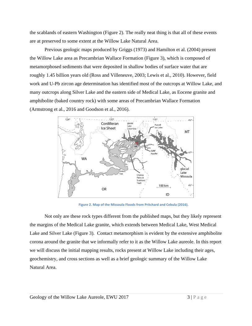
the scablands of eastern Washington (Figure 2). The really neat thing is that all of these events
are at preserved to some extent at the Willow Lake Natural Area.
Previous geologic maps produced by Griggs (1973) and Hamilton et al. (2004) present
the Willow Lake area as Precambrian Wallace Formation (Figure 3), which is composed of
metamorphosed sediments that were deposited in shallow bodies of surface water that are
roughly 1.45 billion years old (Ross and Villeneuve, 2003; Lewis et al., 2010). However, field
work and U-Pb zircon age determination has identified most of the outcrops at Willow Lake, and
many outcrops along Silver Lake and the eastern side of Medical Lake, as Eocene granite and
amphibolite (baked country rock) with some areas of Precambrian Wallace Formation
(Armstrong et al., 2016 and Goodson et al., 2016).
Figure 2. Map of the Missoula Floods from Pritchard and Cebula (2016).
Not only are these rock types different from the published maps, but they likely represent
the margins of the Medical Lake granite, which extends between Medical Lake, West Medical
Lake and Silver Lake (Figure 3). Contact metamorphism is evident by the extensive amphibolite
corona around the granite that we informally refer to it as the Willow Lake aureole. In this report
we will discuss the initial mapping results, rocks present at Willow Lake including their ages,
geochemistry, and cross sections as well as a brief geologic summary of the Willow Lake
Natural Area.

Geology of the Willow Lake Aureole, EWU 2017 4 | P a g e
Figure 3: Geologic Map of the Willow Lake area. Location map of Washington State (showing counties) in upper right corner. Geologic Map from Washington Department of Natural Resources, 1:1000,000 map. Samples locations are presented as circles with stars, U‐Pb samples are labeled, ML1, 11CP37, and WL‐4. The red color signifies the Eocene granodiorite, what this study calls the Medical Lake granite.
Methods
Field and geochemical work was conducted to determine the geologic history of the Willow
Lake Natural Area. Due to the close proximity of Willow Lake to EWU there have been
multiple visits to the site, as opposed to one distinct mapping event. Geochemical analyses of
samples were conducted at the Peter Hooper Memorial GeoAnalytical Laboratory on the
Pullman Campus of Washington State University, including:
1. Whole rock analysis using X-ray Fluorescence (XRF) for major elements, generally with
lighter atomic masses (Johnson et al., 1999) and whole rock analysis using inductively
coupled plasma-mass spectrometry (ICP-MS) for trace elements with generally higher
atomic masses.

Geology of the Willow Lake Aureole, EWU 2017 5 | P a g e
2. JEOL 8500F field emission electron microscope to analyze minerals using a beam size of
3 micrometers, and an accelerating voltage of 15 keV and beam current of 20 nA.
Resultant mineral analyses are used for classification of mineral types and to determine
the temperature and pressure that the magma crystallized, or geothermobarometry.
3. Uranium lead (U-Pb) age determination of zircon grains from samples to determine the
approximate age of the magma intrusion. Analyses were conducted using a New Wave
UP-213 laser ablation system and analyzed with a ThermoFinnigan Element 2 single
collector double-focusing magnetic sector ICP-MS. Operating procedures and parameters
are fully discussed by Chang and others (2006).
Petrographic microscopes and Bruker Tracer III portable XRF analyses were also conducted at
Eastern Washington University.
Results
In this section, we present the geologic map of the Willow Lake Natural Area (Figure 4)
followed by a brief description of the rock types. General geochemical results are also presented
to classify the rock types and describe the age of the granite and formation of the Willow Lake
aureole. Data tables and more detailed geochemical results we plan publishing in a geoscience
journal at a later date.

Geology of the Willow Lake Aureole, EWU 2017 6 | P a g e
Figure 4. Geologic Map of the Willow Lake Natural Area showing major rock types found on the property. The
orientation of the Wallace formation is presented in a classic geologic way, the strike and dip, the dip (small tick mark)
points in the direction that water would flow down each layer of a sedimentary or metamorphic rock with the angle in
degrees from a horizontal surface.
LithologyorRockTypesatWillowLake(youngesttooldest)
QuaternaryDeposits:
The most recent deposits around Willow Lake have been grouped into Quaternary deposits,
including salt deposits, landslide deposits and glacial outburst flood deposits.
As the water levels of Willow Lake lower during late summers, salt deposits are common along
the banks (Figure 5). Crystals form when the lake evaporates and the dissolved chemicals
concentration and crystallize to form minerals around the lake margins. These types of minerals
are usually referred to as evaporates by geologists.
Geology of the Willow Lake Aureole, EWU 2017 7 | P a g e
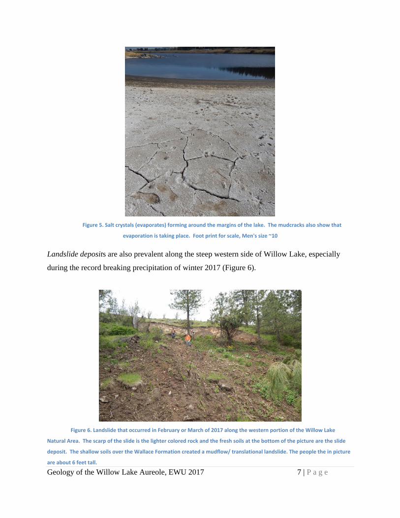
Figure 5. Salt crystals (evaporates) forming around the margins of the lake. The mudcracks also show that
evaporation is taking place. Foot print for scale, Men's size ~10
Landslide deposits are also prevalent along the steep western side of Willow Lake, especially
during the record breaking precipitation of winter 2017 (Figure 6).
Figure 6. Landslide that occurred in February or March of 2017 along the western portion of the Willow Lake
Natural Area. The scarp of the slide is the lighter colored rock and the fresh soils at the bottom of the picture are the slide
deposit. The shallow soils over the Wallace Formation created a mudflow/ translational landslide. The people the in picture
are about 6 feet tall.

Geology of the Willow Lake Aureole, EWU 2017 8 | P a g e
Other Quaternary deposits in the area are sand and gravel deposited by the ice age glacial
outburst megafloods, which repeatedly scoured out the area and during the waning stages of
flooding coarse sediment was deposited. Figure 7 shows the general direction of the outburst
floods and sculpted hills surrounding Willow Lake. Numerous publications discuss the Missoula
floods and we highly recommend visiting the WA Dept. of Natural Resources website at
https://wadnr.maps.arcgis.com/apps/Cascade/index.html?appid=84ea4016ce124bd9a546c5cbc58
f9e29 and EWU student stories about local geology and history at www.floodexplorer.org.
Figure 7. LiDAR image of the relative slope in the area. The rounded portions are higher areas where soils were not
scoured by the southwest‐flowing Missoula Floods (indicated by the blue arrow), whereas Willow Lake and Granite Lake
were scoured out by the megafloods and extensive sand and gravel deposits were left to the north of Willow Lake.
MaficDikes:
Multiple mafic dikes are found cross cutting other rock types, near the parking space and gate
into the Willow Lake Natural Area (Figure 8). This rock is fine grained with a distinctive
weathered surface. The weathered surface of this rock displays pseudo-vesicles likely due to
differential weathering and is gray in color. There are commonly inclusions of other (older)
rocks in the mafic dikes and the contacts with the granite locally shows signs of folding, but are
generally abrupt contacts. The geologic description of this rock type is: Fine-grained mafic dike,

Geology of the Willow Lake Aureole, EWU 2017 9 | P a g e
fresh surface is dark, the weathered surface is light gray with weathered pits, aphanitic with
micro-plagioclase and serpentine, disseminated sulfides and metals (Figure 9).
Figure 8. Photograph of a mafic dike with rounded inclusions of granite and pegmatite. The photo to the left looks
straight down at the mafic dike, blue pen for scale. Near the top of the photo and the bottom there are sharp contacts with
the green and laminated host rock of the Wallace Formation. The photo to the right is looking northwest along the strike of
the dike. The white layers at the bottom of the photo are evaporate minerals left by the lowering of Willow Lake. Site is
located along the southwestern shores of Willow Lake.
MainMineralsoftheMaficDike(estimatedvolumetric%):
• Plagioclase: 40% Plagiocase feldspar laths range in size from <1mm to 1mm. The laths are colorless with low relief under plain polar light (PPL). Under cross-polarized light (XPL) polysynthetic twinning is easily seen with inclined extinction and first order interference colors. Two cleavage directions can be seen at ~90 degrees. • Titaniferous Augite: 30% The groundmass includes mainly small crystals of augite that appear as a rusty brown very fine-grained mass. • Serpentine: 20% Serpentine appears where olivine has been altered. Serpentine formed after the initial mafic intrusion since it replaced grains of olivine, commonly surrounding grains or completely replacing olivine crystals (Figure 9). • Olivine: 10% These crystals are colorless under PPL, with a low relief to the surrounding augite. Under XPL the characteristic equant shape and high birefringence readily identifies it as olivine. The crystals are small, the largest of which are 1/2mm in size. The crystals of olivine show extensive alteration in some cases where the crystal has almost been completely serpentinized.

Geology of the Willow Lake Aureole, EWU 2017 10 | P a g e
Serpentine
Feldspar
Olivine
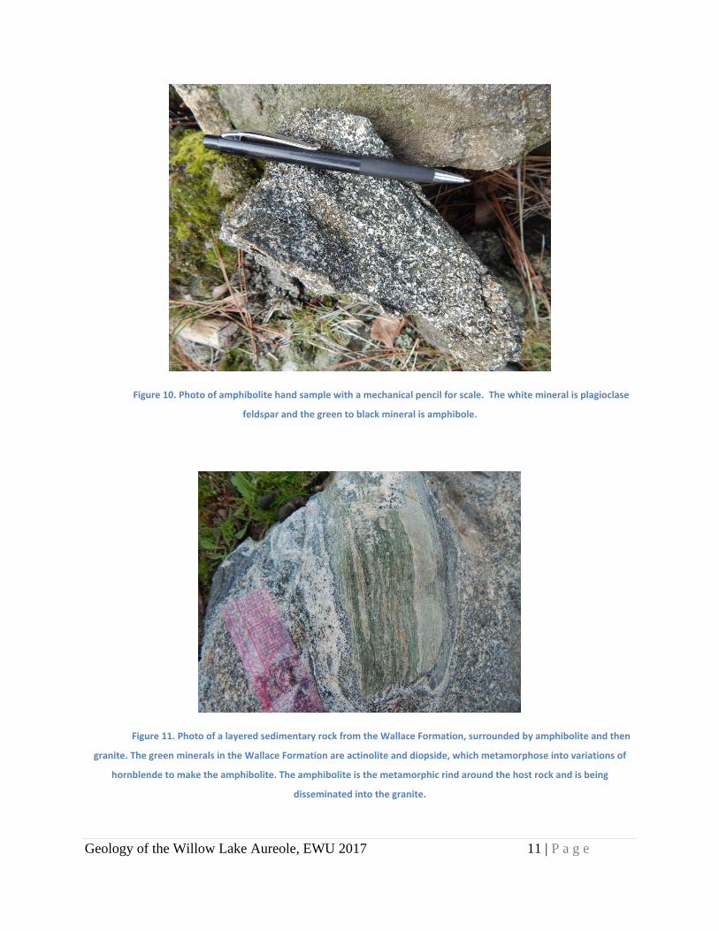
Amphibolite:
Amphibolite is extensive throughout the Willow Lake area, generally at the contact between the
Wallace Formation and granite. It is mostly black and green with white grains included. It is
coarse in texture, containing grains up to 3mm in size and as small as ¼ mm (Figure 10). The
largest grains are hornblende and biotite. The amphibolite is metamorphic rock produced from
the Wallace Formation and is due to increased temperature from the intrusion resulting in contact
metamorphism. We will discuss later that we believe that the granite is derived from melting the
deeper rocks from the Belt Supergroup and that amphibolite is likely the first stage of the
melting, as the wall rock becomes thermally equilibrated to the granite prior to reaching the
melting point (Figure 11). The geologic description is: Amphibole schist, fine-grained to coarse-
grained (amphibolte porphyroblasts up to 2 cm long, generally ~1cm, Figure 12), foliated ~ 350o,
39oE, gray to green, felspar and quartz and micro-muscovite present.
Figure 9. Photomicrograph of the
mafic dikes along the southwestern
portion of the Willow Lake Natural
Area.
Geology of the Willow Lake Aureole, EWU 2017 11 | P a g e
Figure 10. Photo of amphibolite hand sample with a mechanical pencil for scale. The white mineral is plagioclase
feldspar and the green to black mineral is amphibole.
Figure 11. Photo of a layered sedimentary rock from the Wallace Formation, surrounded by amphibolite and then
granite. The green minerals in the Wallace Formation are actinolite and diopside, which metamorphose into variations of
hornblende to make the amphibolite. The amphibolite is the metamorphic rind around the host rock and is being
disseminated into the granite.

Geology of the Willow Lake Aureole, EWU 2017 12 | P a g e
MainMineralsoftheAmphibolite(estimatedvolumetric%):
• Hornblende: 50% Large euhedral elongated prismatic grains, that range in size from 1 to 3mm. These grains are light green in color with medium relief and strong green pleochroism. Under cross polarized (XPL) light these grains display a high birefringence. This mineral occurs commonly as porphyroblasts throughout this rock type, though never exceeding 5mm in size. • Biotite: 20% Small to medium sized anhedral crystals, size ranges from <1mm to >1mm in size. These grains display a strong pleochroism of reddish brown to yellowish brown in plane polarized light. Biotite grains contain a single direction of cleavage. Under XPL these grains display a very characteristic birds eye extinction. • Chlorite: 15% Small 1mm and under in size and anhedral grains that occur as an alteration product of biotite. This mineral display a weak green pleochroism and a fibrous nature with a single direction of cleavage, birds eye extinction, and high birefringence. • Plagioclase: 15% Small 1mm scale anhedral crystals with low relief. Under XPL these grains are identified by their distinctive polysynthetic twinning.
AccessoryMinerals
• Garnet: Small garnet grains can be found very rarely within the sample. These occur up to once in each thin section and are very small, around 1/4th of a mm in size. • Opaque Inclusions: Very small needle like inclusions found only within the chlorite grains.
Figure 12: Microphotographs of the minerals from the amphibolite portion at Willow Lake under different types of filtered light, XPL (left) and PPL (right). Each picture is of an area 3mm wide, magnified using 2.5 magnification and camera zoom. These pictures show that the rock has suitable minerals for our study, including: hornblende, biotite, plagioclase and alkali
feldspar and zircon.
Geology of the Willow Lake Aureole, EWU 2017 13 | P a g e
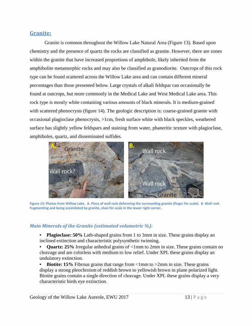
Granite:
Granite is common throughout the Willow Lake Natural Area (Figure 13). Based upon
chemistry and the presence of quartz the rocks are classified as granite. However, there are zones
within the granite that have increased proportions of amphibole, likely inherited from the
amphibolite metamorphic rocks and may also be classified as granodiorite. Outcrops of this rock
type can be found scattered across the Willow Lake area and can contain different mineral
percentages than those presented below. Large crystals of alkali feldspar can occasionally be
found at outcrops, but more commonly in the Medical Lake and West Medical Lake area. This
rock type is mostly white containing various amounts of black minerals. It is medium-grained
with scattered phenocrysts (figure 14). The geologic description is: coarse-grained granite with
occasional plagioclase phenocrysts, >1cm, fresh surface white with black speckles, weathered
surface has slightly yellow feldspars and staining from water, phaneritic texture with plagioclase,
amphiboles, quartz, and disseminated sulfides.
Figure 13: Photos from Willow Lake. A. Piece of wall rock deforming the surrounding granite (finger for scale). B. Wall rock fragmenting and being assimilated by granite, shoe for scale in the lower right corner.
MainMineralsoftheGranite(estimatedvolumetric%):
• Plagioclase: 50% Lath-shaped grains from 1 to 3mm in size. These grains display an inclined extinction and characteristic polysynthetic twinning. • Quartz: 25% Irregular anhedral grains of <1mm to 2mm in size. These grains contain no cleavage and are colorless with medium to low relief. Under XPL these grains display an undulatory extinction. • Biotite: 15% Fibrous grains that range from <1mm to >2mm in size. These grains display a strong pleochroism of reddish brown to yellowish brown in plane polarized light. Biotite grains contain a single direction of cleavage. Under XPL these grains display a very characteristic birds eye extinction.

Geology of the Willow Lake Aureole, EWU 2017 14 | P a g e
1mm
• Orthoclase: 10% These grains are usually smaller than the plagioclase grains averaging around 1mm in size. Orthoclase grains contain right angle cleavages and nearly parallel extinction angles.
Accessory Minerals:
• Chlorite: 5% Small <1mm and smaller anhedral grains that occur as an alteration product of biotite. Chlorite minerals display a weak green pleochroism and a fibrous nature with a single direction of cleavage, birds eye extinction, and high birefringence. • Opaques:A very small amount of opaque minerals can be found, ranging in sizes well under 1mm.
WallaceFormationofthePieganGroup:
The wall rock, or host rock, at the area is the Wallace Formation of the Peigan Group of
the Belt Supergroup, approximately 1.45 billion years old (Link et al., 2007). The rocks are
generally thinly bedded green to white layers of metamorphosed calcareous sediment and sand
(Figures 15 and 16). Coarse white quartzite layers are present at a few locations. The geologic
description is: fine-grained calc-silicate, foliated to massive, fresh surface green with white
bands commonly containing amphibole phenocrysts (actinolite). The weathered surface is dull
green sometimes brown (possible mineralization from lake), aphanitic quartz and amphibole
Figure 14. Photomicrograph of the granite,
showing the major mineral types.

Geology of the Willow Lake Aureole, EWU 2017 15 | P a g e
composition. The sediments in the Wallace Formation are heterogeneous, but generally consist
of quartz, feldspar, actinolite, zircon and disseminated sulfides. Bedding and/ or foliation of the
Wallace Formation is generally striking north to northwest and dipping 40o to 60o to the east
(Figure 17).
Figure 15. Photo of the Wallace Formation, green laminated calc‐silicate.
Figure 16. Photo of the host rock deformed and metamorphosed by the granite, as evident by the quartz and
feldspar rich veins between blocks of the layered calc‐silicate.
Geology of the Willow Lake Aureole, EWU 2017 16 | P a g e
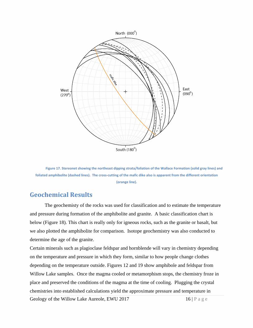
Figure 17. Stereonet showing the northeast dipping strata/foliation of the Wallace Formation (solid gray lines) and
foliated amphibolite (dashed lines). The cross‐cutting of the mafic dike also is apparent from the different orientation
(orange line).
GeochemicalResults
The geochemisty of the rocks was used for classification and to estimate the temperature
and pressure during formation of the amphibolite and granite. A basic classification chart is
below (Figure 18). This chart is really only for igneous rocks, such as the granite or basalt, but
we also plotted the amphibolite for comparison. Isotope geochemistry was also conducted to
determine the age of the granite.
Certain minerals such as plagioclase feldspar and hornblende will vary in chemistry depending
on the temperature and pressure in which they form, similar to how people change clothes
depending on the temperature outside. Figures 12 and 19 show amphibole and feldspar from
Willow Lake samples. Once the magma cooled or metamorphism stops, the chemistry froze in
place and preserved the conditions of the magma at the time of cooling. Plugging the crystal
chemistries into established calculations yield the approximate pressure and temperature in

Geology of the Willow Lake Aureole, EWU 2017 17 | P a g e
which these minerals formed. This project used the aluminum-in-hornblende barometer of
Anderson and Smith (1995) and hornblende-plagioclase thermometer of Holland and Blundy
(1994) and Putirka (2008). Generally these analyses indicated an average of ~ 7 km depth for
formation of the amphibolite and temperatures around 685 degrees Celsius. Estimated
temperature using two feldspars generally agrees with these values (Figure 20).
Figure 18. Total alkali versus silca plot (Cox et al., 1979). This is a classification chart for the granites and mafic dike.
Amphibolite samples are also plotted, with the coarse‐grained amphibolite containing less silica than the fine grained
variety. These are whole‐rock XRF data.
Figure 19. Backscatter image using electron microscopy of feldspar and amphiboles from an amphibolite sample.
Grains from this sample averaged geobarometry values equivalent to about 7km depth.
The age of granite was estimated to be about 48 million years old based upon 15 zircon
analyses from Willow Lake granite. These zircons also had cores with ages about 1.4 to 1.6
billion years old. An image of a zircon from a granite sample (WL-4) is shown in Figure 21.

Geology of the Willow Lake Aureole, EWU 2017 18 | P a g e
Though these grains are small, they are stable at high temperatures and strong enough to resist
being broken during weathering and fracturing, making them ideal to preserve the age of felsic
igneous rocks.
Figure 20. Feldspar chemistry from local granite samples.

Geology of the Willow Lake Aureole, EWU 2017 19 | P a g e
Figure 21. Image of a zircon from a granite sample taken from Willow Lake. The pit in the center of the zoned
crystal is the hole drilled out using laser ablation. The material that was removed from the pit was sucked into a mass
spectrometer and used to determine the age of this grain.
Discussion
U-Pb age determinations of zircon from the Medical Lake granite indicates it is about 48
million years old. This is similar in age to core complexes in the area. Results also generally
agree with other pressures and temperatures where the upper crust has been unroofed during
Eocene uplift (Stevens et al., 2015; Doughty et al., 2016; Yonkee and Weil, 2015) and other
local granite (Campbell and Pritchard, 2012; Shillhammer and Pritchard, 2013). Recent work has
suggested that similar uplift rates (~7 km in the last 50 million years, or about 5 to 10 mm/ year)
were likely due to thrust faults deep in the crust (aka, underthrusting). What we find at the
Willow Lake area seems to agree with deep intrusions being emplaced into a tectonically active
area during the Eocene (Figure 22).
Figure 22. Generalized cross section of the Willow Lake area, showing the thin veneer of Wallace Formation,
metamorphosed to amphibolite, and two cross‐cutting mafic dikes. This is called a roof pendant because there is just a thin
rock covering the larger igneous rock or granitic intrusion at depth.

Geology of the Willow Lake Aureole, EWU 2017 20 | P a g e
Our interpretation of the area is that the 1.45 billion year old Wallace formation was
probably regionally deformed in the Cretaceous period due to accretion of the western portion of
Washington State. Deeper Belt Supergroup rocks were melted about 48 million years ago at
approximately 12 to 5 km depth forming the amphibolite at the zones where the host rock had
time to equilibrate to the magmatic temperature about 680 to 690 degrees Celsius (1250 to 1270
degrees Fahrenheit).
As the granitic magma cooled, it was injected by mafic dikes. The relative ages of the
dikes can be quickly deduced since the dikes cross-cut other rocks (Figure 22). Inclusions in the
mafic dikes are granite, pegmatite, and Wallace Formation. Since there is some ductile folding
of the granites at the contact, we infer that the dikes intruded the granite sometime during the late
stages of cooling, or around 47 to 48 million years ago in the Eocene epoch.
Shear related structural features are also present, such as porphyroclast rotation, folding,
and re-crystalized blastomylonites. The depth of amphibolite emplacement agrees with other
regional findings in the Priest River complex (Rhodes, 1986) and the ages also correlate well
with regional core complex formation, post Sevier orogeny (Stevens et al. 2015; Doughty et al.,
2016). More recent structures in the area are associated with the Cheney fracture zone, which
may have some implications for local groundwater flow and basement faulting (Hennings et al.,
2015; Pritchard et al., 2015).
So walking around Willow Lake Natural Area you can look at the unique geology and try
to imagine the complex geologic history while enjoying the beautiful lake. Please remember that
conserving this area helps future generations enjoy this fascinating area, so please do not take
samples or deface the rocks.

Geology of the Willow Lake Aureole, EWU 2017 21 | P a g e
Acknowledgements
Assistance in reviewing this document was appreciated from Mark McFaddan, Dr. Reed
Lewis, and Dr. Peter Larson. Funding for this project was made available by Eastern Washington
University Faculty Research Grants and assistance was greatly appreciated from Janis Hetrick
and multiple Geology 431 (Structural Geology) classes. Laboratory assistance from the
Washington State University Peter Hooper Memorial GeoAnalytical Lab and GeoSep Services
were also greatly appreciated. Look for future stories of the geology, history, and generally neat
things about Willow Lake and the eastern Washington on www.floodexplorer.org.
ReferencesAnderson, JL and Smith, DR (1995) The effects of temperature and fo2 on the Al-in-hornblende
barometer: American Mineralogist, v. 80, p. 549-559. Armstrong, A, Goodson, B., and Pritchard, CJ (2016) Preliminary identification and classification of the
rocky types of Willow Lake, eastern Washington: Geological Society of America Rocky Mountain Section Meeting, May 2016, Moscow, ID - Geological Society of America Abstracts with Programs, v. 28, no. 6, doi: 10.1130/abs/2016RM-276043
Blundy, JD, Brooker, RA, Cooper, FJ, Mutch, EJF and Tattitch, BC (2016) An experimental study of amphibole stability in low pressure granitic magmas and a revised Al in hornblende geobarometer: Contributor Mineral Petrology, vol. 176:85, p. 84-111, DOI 10.1007/s00410-016-1298-9.
Campbell, H and Pritchard, CJ (2012) U-Pb ages of plutons near Long Lake dam and Little Falls dam, Lake Spokane, Washington: National Association of Geoscience Teachers, Pacific Northwest Section, 2012 Annual Conference, Spokane, WA. & 15th Annual EWU Research and Creative Work Symposium, May 2012.
Chang, Z, Vervoort, JD, McClelland, WC, and Knaack, C (2006) U-Pb dating of zircon by LA-ICP-MS. Geochemistry, Geophysics, Geosystems 7, no. 1: Q05009, 14 p.
Cox, KG, Bell, JD, and Pankhurst, RJ (1979) The interpretation of igneous rocks: Allen and Urnwin 450 p.
Doughty, PT, Buddington, AM, Cheney, ES, and Derkey, RE (2016) Geology of the Priest River Metamorphic Complex and adjacent Paleozoic strata south of the Spokane River valley, Washington: in Cheney, E (ed.) Laurentian Geology, UW Press, Seattle WA.
Goodson, B, Armstrong, A, and Pritchard C (2016) Preliminary mapping and structural interpretation of an aureole in eastern Washington: Geological Society of America Abstracts with Programs, v. 28, no. 6, doi: 10.1130/abs/2016RM-276179
Griggs, AB (1973) Geologic map of the Spokane quadrangle, Washington, Idaho, and Montana: United States Geological Survey, map I-768, scale 1:250,000.
Holland, T and Blundy (1994) Non-ideal interactions in calcic amphiboles and their bearing on amphibole-plagioclase thermometry: Contributions to Mineralogy and Peterology, v. 116, p. 433-447

Geology of the Willow Lake Aureole, EWU 2017 22 | P a g e
Hamilton, MM, Derkey, RE, and Stradling, DF (2004) Geologic map of the Four Lakes 7.5-minute quadrangle, Spokane County, Washington. Washington Division of Geology and Earth Resources Open File Report 2004-2, 1 sheet, scale 1:24,000.
Hennings, C, Lund, B, and Pritchard, CJ (2015) Vertical propagation of lateral slip in basement rock as instigator for the Cheney Fracture Zone, eastern Washington: A fracture analysis, Abstract, NCUR, April 2015, Cheney, WA
Johnson, DM, Hooper, PR, and Conrey, RM (1999) XRF analysis of rocks and minerals for major and trace elements on a single low dilution Li-tetraborate fused bead: Advances in X-ray Analysis, v. 41, p. 843-867.
Kiver, E, Pritchard, CJ, and Orndorff, R (2016) Washington Rocks! A guide to geologic sites in the Evergreen State: Montana Press Publishing, Missoula Montana, 131 p.
Lewis, RS, Vervoort, JD, Burmester, RF, and Oswald, PJ (2010) Detrital zircon analysis of Mesoproterozoic and Neoproterozoic metasedimentary rocks of north-central Idaho: implications for development of the Belt-Purcell basin: Canadian Journal of Earth Science, v. 47, p. 1383-1404, doi:10.1139/E10-049.
Link, PK, Fanning, CM, Lund, KI, and Aleinikoff, JN (2007) Detrital-zircon populations and provenance of Mesoproterozoic strata of east-central Idaho, U.S.A: Correlation with Belt Supergroup of southwest Montana: in Link, P.K., and Lewis, R.S., eds., SEPM Special Publication 86, Proterozoic geology of western North America and Siberia, p.101-128.
Lund, K, Aleinikoff, JN, Evans, KV, and Fanning, CM (2003) SHRIMP U-Pb geochronology of Neoproterozoic Windermere Supergroup, central Idaho: Implications for rifting of western Laurentia and synchronicity of Sturtian glacial deposits: GSA Bulletin, v. 115, p. 349-372.
Pritchard, CJ, Hennings, C, Lund, B, and Ernst, S (2015) Possible Influences of the Cheney Fracture Zone and paleodrainages on basalt aquifers of the West Plains, eastern Washington: Northwest Scientific Association 86th Annual Conference, April 2015, Pasco, WA.
Pritchard, CJ and Cebula, L (2016) Geologic and anthropogenic history of the Palouse Falls area: Floods, fractures, clastic dikes, and the receding falls, in: Lewis, R.S., and Schmidt, KL, eds., Exploring the Geology of the Inland Northwest: Geological Society of America Field Guide 41, doi:10.1130/2016.0041(02).
Putirka, KD (2008) Thermometers and barometers for volcanic systems. In: Putirka KD, Tepley FJ III (ed) Minerals, Inclusions, and Volcanic Processes, Reviews of Mineralogy and Geochemistry. Mineralogical Society of America v. 69, p. 61-111.
Rhodes, BP (1986) Metamorphism of the Spokane Dome mylonitic zone, Priest River Complex; constraints on the tectonic evolution of northeastern Washington and northern Idaho: Journal of Geology, Vol. 94, p. 539-556.
Ross, GM and Villeneuve, M (2003) Provenance of the Mesoproterozoic (1.45 Ga) Belt basin (western North America): Another piece in the pre-Rodina paleogeographic puzzle: Geological Society of America Bulletin, v. 115, no. 10, p. 1191-1217
Sears, JW (2012) Transforming Siberia along the Laurussian margin: Geology, v. 40, p. 535-538, doi:10.1130/G32952.
Shillhammer, S and Pritchard, CJ (2013) Window into the Cenozoic tectonic history of eastern Washington: geochronology and microstructures of an intruded fault plane: Abstract, 27th National Conference on Undergraduate Research (NCUR), April 2013, La Crosse, Wisconsin.
Stevens, LM, Baldwin, JA, Cottle, JM, and Kylander-Clark, ARC (2015) Phase equilibria modelling and LASS monazite petrochrnology: P-T-t constrains on the evolution of the Priest River core complex, northern Idaho: Journal of Metamorphic Geology, v. 33, p. 385-411. Doi:10.1111/jmg.12125.
Yonkee, WA and Weil, AB (2015) Tectonic evolution of the Sevier and Laramide belts within the North American Cordillera orogenic system: Earth Science Reviews, v. 150, p. 531-593, http://dx.doi.org/10.1016/j.earscirev.2015.08.001.