Embed Size (px)
Citation preview

WILLAMETTE RIVER MIDDLE FORK
STATE PARKS MASTER PLAN
July 2006

Acknowledgments
OPRD Director: Tim Wood, Director Dave Wright, Assistant Director of Operations
OPRD Staff: Ron Campbell, Master Planning Coordinator Jeff Farm, Area 3 Manager
Sven Anderson, Assistant Area 3 Manager Kees Ruurs, Southern Willamette Mgmt Unit Park Manager
Cliff Houck, Resource Management & Planning Division Manager Kathy Schutt, Master Planning Manager
Tammy Baumann, Master Planning Assistant Brady Callahan, GIS Program Coordinator
Advisory Name Representing Committee: Steve Barrett................................Sky Camp
Celia Barry ..................................Lane County Planning and Public Works Dustin Bengtson .........................Army Corps of Engineers Lowell Service Center
Amy Chinitz, .............................Middle Fork Willamette Watershed Council Eve Montanaro ...........................Middle Fork Willamette Watershed Council Debbie Eagan..............................Lowell Public Schools Guy Harshbarger.........................Dexter Fire District / local emergency services Deb Harvey.................................Eugene to Pacific Crest Trail Dave Horton...............................Oregon Association of Rowers Kent Howe.................................Lane County Land Management Division Bob Keefer ..................................Local Public Parks Jeff Krueger .................................Lane Council of Governments Ken Larsen ..................................City of Lowell Paul Mize ....................................Eugene Disk Golf Mike Owen.................................Local Community Interests Wayne Shuyler ............................Oregon State Marine Board Chuck Solin ................................ORTAC Sandy Vaughn.............................UO Club Sports Program Della Webb.................................Equestrian and Other Trail User Groups Jeff Ziller.....................................ODFW Springfield Field Office
Other Contributors Special thanks to various other OPRD staff who contributed insight, ideas and information, including: Becky Simmons, Steve Wilson, Julie Whalen, Trevor Rigmaiden, Sean Stewart, Paul Tollenaar, Jay Schleier, Kristen Stallman, Sean Loughran, Terry Bergerson, Russ Richards and Jay Beeks; and to Kat Beal of ACOE, and various representatives of Oregon Association of Rowers, Oregon Equestrian Trails, and Back Country Horsemen of Oregon.
Contacts: Kees Ruurs, Park Manager (541) 937-1173
Ron Campbell, Master Planning Coordinator (503) 986-0743
Kathy Schutt, Master Planning Manager (503) 986-0745

W i l l a m e t t e R i v e r M i d d l e F o r k S t a t e P a r k s M a s t e r P l a n
July 2006 Plan i
Table of Contents
I. Introduction ...........................................................................................1
Purpose................................................................................................. 1Authority ............................................................................................... 1Benefits of a Master Planning Process .................................................... 1Process for Completing a Master Plan .................................................... 2Conceptual Designs for Park Development Projects ................................ 5General Parameters for Design.............................................................. 5Master Plan Implementation and Amendments ...................................... 6NEPA Compliance ................................................................................. 6Why Master Plan These Parks Now?....................................................... 6
II. Master Plan Summary ...........................................................................9
III. Planning Context .................................................................................11
Location .............................................................................................. 11Physiographic Setting........................................................................... 11Landscape Character........................................................................... 11The Neighborhood .............................................................................. 11Zoning ................................................................................................ 12Planning Area Size .............................................................................. 13OPRD’s Role as a Statewide Recreation Provider .................................. 14Recreation in the Sub-region ............................................................... 15
IV. Heritage Assessment...........................................................................21
Hydrologic Setting ............................................................................... 21Flood Hazards ..................................................................................... 22Plant Communities and Conditions ...................................................... 22Wildlife................................................................................................ 24At-Risk Species .................................................................................... 25Recreation Settings .............................................................................. 26Cultural Resources............................................................................... 27
V. Recreation Needs & Opportunities .....................................................29
SCORP ................................................................................................ 29Local Indicators ................................................................................... 30
VI. Suitability Assessments .......................................................................33
Resource Inventories............................................................................ 33Resource Suitability Assessments and Composite Suitability.................. 33Composite Suitability Ratings ............................................................... 35
VII. Issues ...................................................................................................53

W i l l a m e t t e R i v e r M i d d l e F o r k S t a t e P a r k s M a s t e r P l a n
July 2006 Plan ii
How Issues are Compiled and Addressed............................................. 53Summary of Issue Scoping Comments.................................................. 53
VIII. Goals And Strategies...........................................................................65
Goal: Protect and enhance outstanding natural, cultural, and scenic resources................................................................................... 65
Goal: Enhance recreation opportunities and experience....................... 66Goal: Provide for adequate management, maintenance, rehabilitation
and park operations. ................................................................. 68Goal: Provide for safe, efficient, identifiable and pleasant access and
circulation. ................................................................................ 69Goal: Promote public awareness, understanding, appreciation, and
enjoyment of the recreation setting through resource interpretation. ........................................................................... 70
Goal: Form partnerships and agreements to aid in achieving goals...... 70
IX. Development Concepts For Jasper State Recreation Site & Two Willamette River Greenway Parcels....................................................73
Setting and Character.......................................................................... 73Resource Suitability.............................................................................. 74Existing Uses and Facilities................................................................... 74Park Issues, Opportunities, and Objectives........................................... 75Jasper SRS Development Projects ......................................................... 81
X. Development Concepts For Elijah Bristow State Park & Pengra Access ..................................................................................89
Setting and Character.......................................................................... 89Resource Suitability.............................................................................. 90Existing Uses & Facilities ...................................................................... 91Park Issues, Opportunities, and Objectives........................................... 92Elijah Bristow Development Projects ..................................................... 99Pengra Access Development Projects ................................................. 113
XI. Development Concepts For Dexter & Lowell State Recreation Sites ................................................................................ 117
Setting and Character........................................................................ 117Resource Suitability............................................................................ 118Existing Uses and Facilities................................................................. 119Park Issues, Opportunities, and Objectives......................................... 120Dexter SRS Development Projects....................................................... 125Lowell SRS Development Projects ....................................................... 131
XII. Development Concepts for Winberry & North Shore Parks............. 141
Setting and Character........................................................................ 141Resource Suitability............................................................................ 141
W i l l a m e t t e R i v e r M i d d l e F o r k S t a t e P a r k s M a s t e r P l a n
July 2006 Plan iii
Existing Uses and Facilities................................................................. 143Park Issues, Opportunities, and Objectives......................................... 144Winberry Park Development Projects.................................................. 149North Shore Park Development Projects............................................. 157
XIII. Development Concepts For Sky Camp.............................................. 161
Setting and Character........................................................................ 161Resource Suitability............................................................................ 161Existing Uses and Facilities................................................................. 162Park Issues, Opportunities, and Objectives......................................... 163Sky Camp Development Projects........................................................ 167
XIV. Development Concepts For Cascara Campground, Fisherman’s Point Group Camp, Free Meadow, Lakeside 1 & 2 ................................... 173
Setting and Character........................................................................ 173Resource Suitability............................................................................ 174Existing Uses and Facilities................................................................. 175Park Issues, Opportunities, and Objectives......................................... 176Cascara Campground Development Projects...................................... 181Fisherman’s Point Group Camp Development Projects ....................... 185Free Meadow Development Projects .................................................. 189Lakeside 1 Development Projects ....................................................... 193Lakeside 2 Development Projects ....................................................... 197
XV. Areas Of Interest .............................................................................. 201
Future Acquisition Interests ................................................................ 201Future ACOE Land Lease Interests ..................................................... 201Development Concepts for Future ACOE Lease Areas ........................ 201
XVI. Natural, Cultural & Scenic Resource Management.......................... 203
Natural Resource Management ......................................................... 203Natural Resource Policy ..................................................................... 203Statewide Natural Resource Management Objectives......................... 203General Guidelines for Natural Resources in the Planning Area ......... 205Concepts for Future Ecosystem Management ..................................... 211Scenic Resource Management............................................................ 212Cultural Resource Management......................................................... 213
XVII. Summary Of Land Use Approval Requirements .............................. 231
Land Use Approval of the Master Plan ............................................... 231Development Permits for State Park Projects....................................... 231Variations from the Master Plan......................................................... 231Rehabilitation of Existing State Park Uses ........................................... 232
Appendix A Native Plant Associations ........................................................ 233
Appendix B Habitat Types & Closely Associated Wildlife ............................ 247

W i l l a m e t t e R i v e r M i d d l e F o r k S t a t e P a r k s M a s t e r P l a n
July 2006 Plan iv
Appendix C Historic Gaged River Flows ....................................................... 251
Appendix D Projects for Existing Facility Rehab, Upgrades, and Accessories ................................................................................ 253

W i l l a m e t t e R i v e r M i d d l e F o r k S t a t e P a r k s M a s t e r P l a n
July 2006 Plan v
Table of Maps & Illustrations
Vicinity Map .......................................................................................................... 17
Study Area ............................................................................................................ 19
Composite Suitability: Jasper SRS & Unnamed WRG Parcel ................................... 37
Composite Suitability: Green Island Landing ........................................................ 39
Composite Suitability: Elijah Bristow West & Pengra Access.................................. 41
Composite Suitability: Elijah Bristow East & Dexter SRS ......................................... 43
Composite Suitability: Lowell SRS ......................................................................... 45
Composite Suitability: Winberry & North Shore Parks............................................ 47
Composite Suitability: Sky Camp .......................................................................... 49
Composite Suitability: Cascara Campground, Fisherman’s Point, Free Meadow, Lakeside 1, and Lakeside 2 ................................................................................... 51
Jasper SRS Existing Ownership & Facilities ............................................................. 77
Green Island Landing Existing Ownership & Facilities. ........................................... 79
Jasper Administration Area Development Concept ................................................ 85
Jasper Picnic Area Development Concept .............................................................. 87
Elijah Bristow West and Pengra Access Existing Ownership & Facilities ................... 95
Elijah Bristow East Existing Ownership & Facilities .................................................. 97
Elijah Bristow Entrance & Administration Area Development Concept................... 103
Elijah Bristow Picnic Area and Trailhead Development Concept ........................... 105
Elijah Bristow Equestrian Area Development Concept .......................................... 107
Elijah Bristow West Trails Plan ............................................................................. 109
Elijah Bristow East Trails Plan............................................................................... 111
Pengra Access Development Concept .................................................................. 115
Dexter & Lowell Existing Ownership & Facilities .................................................. 123
Dexter SRS Development Concept ....................................................................... 129
Lowell SRS Day Use Area Development Concept ................................................. 135
Lowell SRS Cabin Alternative Development Concept ............................................ 137
Lowell SRS Campground Alternative Development Concept................................. 139
Winberry and North Shore Ownership & Facilities ............................................... 147
Winberry Park Campground Alternative Development Concept............................ 153

W i l l a m e t t e R i v e r M i d d l e F o r k S t a t e P a r k s M a s t e r P l a n
July 2006 Plan vi
Winberry Park Group Camp Alternative Development Concept............................ 155
North Shore Park Development Concept ............................................................. 159
Sky Camp Existing Ownership & Facilities ............................................................ 165
Sky Camp Development Concept ........................................................................ 171
Cascara Campground, Fisherman’s Point, Free Meadow, Lakeside 1, and Lakeside 2 Existing Ownership and Facilities......................................................................... 179
Cascara Campground Development Concept ...................................................... 183
Fisherman’s Point Group Camp Development Concept........................................ 187
Free Meadow Development Concept................................................................... 191
Lakeside 1 Development Concept ....................................................................... 195
Lakeside 2 Development Concept ....................................................................... 199
Ecosystem Management: Jasper SRS & Unnamed WRG Parcel ............................ 215
Ecosystem Management: Green Island Landing................................................... 217
Ecosystem Management: Elijah Bristow West & Pengra Access ............................ 219
Ecosystem Management: Elijah Bristow East & Dexter SRS................................... 221
Ecosystem Management: Lowell SRS................................................................... 223
Ecosystem Management: Winberry & North Shore Parks ..................................... 225
Ecosystem Management: Sky Camp ................................................................... 227
Ecosystem Management: Cascara Campground, Fisherman’s Point, Free Meadow, Lakeside 1, & Lakeside 2..................................................................................... 229

W i l l a m e t t e R i v e r M i d d l e F o r k S t a t e P a r k s M a s t e r P l a n
July 2006 Plan vii
Additional Willamette River Middle Fork State Parks Master Plan Documents
The following background documents are incorporated into the Willamette River Middle Fork State Parks Master Plan:
Resource Maps of the Parks:
Plan Communities and Conditions (8 maps)
Surface Water Features (8 maps)
Flood Hazards (FEMA Data) (8 maps)
Sensitive Species (4 maps)
Cultural Resource Sensitive Areas (4 maps)
Background Reports:
“Natural Resource Inventory for Natural Vegetation, At-Risk Species and other Fish and Wildlife Resources” (Oregon Natural Heritage Information Center, 2003). Separate reports for:
o Elijah Bristow (includes Dexter & Pengra Access)
o Fall Creek Reservoir Parks
o Lowell
o Jasper
o Green Island Landing
o Unnamed Landing
The above documents are available for viewing at:
Oregon Parks and Recreation Department North Mall Office Building
725 Summer Street NE, Suite C Salem OR 97301

W i l l a m e t t e R i v e r M i d d l e F o r k S t a t e P a r k s M a s t e r P l a n
July 2006 Plan 1
I. INTRODUCTIONPurposeThis master plan outlines the Oregon Parks and Recreation Department’s (OPRD) plans for the future development, use and management of state park lands on the Middle Fork Willamette River and Dexter and Fall Creek reservoirs. Included in the master plan are summaries of the issues, resource assessments, recreation needs, goals, development proposals and resource management guidelines associated with the parks, and the process followed in formulating and adopting the master plan.
The purpose of a state park master plan is to plan for both the protection and public enjoyment of the resources that occur in the parks that are being master planned. Master plans identify and provide for the most appropriate recreational uses based on resource opportunities and constraints, development opportunities and constraints, public recreation needs, and the respective roles of OPRD and other recreation providers. A master plan may also identify lands that OPRD would consider acquiring from willing sellers to add to the state park system, as well as lands that are under OPRD ownership that logically should not be part of the state parks. A master plan also provides a basis for preparing partnership agreements, budget and management priorities and detailed development and management guidelines, and for requesting land use approvals from affected local governments for planned projects.
AuthorityOPRD prepares master plans for its properties under the authorities embodied in state statutes and rules, which include ORS 390.180, OAR 736 Division 18, ORS 195.120 and OAR 660 Division 34.
Benefits of a Master Planning Process A written and illustrated reference is produced containing extensive information about, and long term plans for, the state park lands. This “master plan” is the guide for the parks’ 20-year future. It describes the planning purpose and process, existing facilities in the park, future recreation demand, the suitability of the land for public recreational uses, issues related to public use and management, the goals, objectives and development concepts for the future use and development of the park properties, and guidelines for managing the park resources.
Development concepts in the master plan show how to fit needed facilities into the park. These are the conceptual ‘blueprints” for the park. The development concepts reflect the resource constraints and opportunities and address the goals established in the planning process. They describe the appropriate types, sizes, locations and access for the proposed facilities.
Resource maps, which accompany the master plan document, show various natural, cultural and scenic resources in the park. These maps are invaluable planning tools used frequently

W i l l a m e t t e R i v e r M i d d l e F o r k S t a t e P a r k s M a s t e r P l a n
July 2006 Plan 2
by the park rangers, other resource agencies, policy makers and members of the public or “friends” groups. They are the basis for sound resource management and development decisions.
A public discussion occurs regarding the future of the park. The master planning process is an excellent opportunity for the public to discuss and provide input on the future of the parks. The planning process includes several public meetings and mailings and invites the public to provide written comments on the pertinent issues and the proposals and guidelines established by the master plan.
Partnerships. A master planning process is an opportunity to encourage partnerships with other agencies, interest groups and neighbors to benefit park implementation and management.
Process for Completing a Master Plan The flow chart that follows illustrates the basic steps for completing a master plan.
In the first steps, information is gathered regarding natural, cultural and scenic resources, existing facilities and recreation and interpretive needs, as well as information about the local community.
Issues involving the use, development and management of the park are identified through meetings with department staff, an advisory committee, the local government decision-making body and the general public.
Goals for the future use and development of the parks and management of park resources are determined. Resource management guidelines and development concepts for the parks are formulated. These are checked for consistency with the state land use goals and local government comprehensive plans.
All of the above information is compiled into a draft master plan that is reviewed by department staff, the advisory committee, the interested public and by the OPRD Director and the Oregon Parks and Recreation Commission. Comments are collected and the master plan is edited based on guidance from the Director and Commission.
The edited draft is then presented for adoption as a state rule and approval by affected local governments. Additional comments are received from the public and local government in formal public hearings, which often lead to additional edits prior to final adoption.
(Those who are interested in a more detailed description of the process should contact the Master Planning Section at the OPRD headquarters office in Salem. OAR 736 Division 18 mandates this process.)

W i l l a m e t t e R i v e r M i d d l e F o r k S t a t e P a r k s M a s t e r P l a n
July 2006 Plan 3
Master Planning Process Flow Chart

W i l l a m e t t e R i v e r M i d d l e F o r k S t a t e P a r k s M a s t e r P l a n
July 2006 Plan 5
Conceptual Designs for Park Development Projects State park master plans include text and illustrations that describe appropriate locations, layouts, sizes, and types of proposed recreation facilities. The locations and layouts of development projects are illustrated conceptually. Reasonable flexibility to make changes in the locations and layouts of development project components when completing final designs is expected, provided that such changes do not involve relocation of projects to totally different areas of the parks, or to sites where significant impacts on important natural or cultural resources, other recreation uses or neighboring lands uses may result. Changes in the locations of projects are limited to the park use areas where they are master planned. Preliminary and final project designs will be reviewed in cooperation with the local land use approval authority as needed to ensure compliance with the intent of the master plan.
OPRD is dedicated to proposing facilities that are needed to support outdoor recreation, and that are appropriate for the setting and OPRD’s roles as a recreation provider. Proposed park facilities are selected, located and designed to avoid causing significant impacts on important resources, as identified in the resource suitability assessments prepared for the master plan. The proposed facilities are also selected, located, and designed to avoid causing significant conflicts between incompatible recreation uses or impacts on surrounding land uses.
General Parameters for Design General parameters that are considered in formulating development concepts in state park master plans include the following:
Balancing recreation needs and avoiding or minimizing conflicts between recreation uses;
Providing good access and circulation for vehicles and non-motorized travel within the parks;
Locating and designing facilities, roads and trails in a manner that is understandable by the public in navigating through the parks;
Avoiding significant impacts on important natural, cultural and scenic resources within or adjacent to the parks;
Taking advantage of scenic views and resource interpretation opportunities;
Presenting an appearance that is harmonious with the setting and the region;
Providing choices for visitors who may have different desires for recreation amenities and settings;
Clustering development to keep most of the park lands undeveloped;
Avoiding or mitigating conflicts with local services and neighboring land uses;
Achieving compliance with regulatory requirements including the state land use goals, local comprehensive plans, building codes, resource laws, etc.;
Providing opportunities for access by visitors with disabilities and different economic and cultural backgrounds.

W i l l a m e t t e R i v e r M i d d l e F o r k S t a t e P a r k s M a s t e r P l a n
July 2006 Plan 6
Master Plan Implementation and Amendments Once the state park master plan is adopted as a state rule and determined to be compatible with local government comprehensive plans, any development in the parks must be consistent with the master plan. Minor variations from the adopted master plan may be allowed if such variations are determined by the OPRD Director and the affected local government to be consistent with the master plan in accordance with OAR 736-018-0040. Any use that is not consistent with the master plan requires a master plan amendment. Master plan amendments must follow the same process used to adopt the master plan, as described in OAR 660 Division 34 and OAR 736 Division 18, which includes re-adoption as a state rule and a determination of compatibility with local government comprehensive plans.
Park master plans are amended when changes in circumstances are significant enough to warrant changes. The OPRD Director considers the recommendations of OPRD staff and outside interests in prioritizing the park master plans to be adopted or amended each biennium. The director’s decisions are based on consideration of the following factors:
1. Significant changes in: a Condition of, or threats to, the natural, scenic or cultural resources within or surrounding
the parks. b Knowledge of and need for best management practices for natural, cultural or scenic
resources within the parks. c Recreation demand or needs, or crowding within the parks or the vicinity of the parks. d Partnership opportunities for implementing park projects or managing park resources. e Impacts or potential for impacts from surrounding land uses.
2. Alternatives to amending the master plan that would adequately address changes, such as interagency management agreements, non-OPRD management partnerships, etc.
NEPA Compliance Most of the parks addressed by this master plan are located on federal lands that OPRD leases from the Army Corps of Engineers (ACOE). Compliance with the requirements of the National Environmental Policy Act (NEPA) must be demonstrated for projects located on the federal lands. The NEPA process will be conducted in coordination with ACOE prior to implementation of each project. The NEPA process is not required prior to adoption of the master plan.
Why Master Plan These Parks Now? Several factors are considered in determining which parks will be master planned each year within the State Park system. OPRD’s Director sets master plan completion priorities after a review of staff recommendations. The Middle Fork Willamette River State Parks Master Plan was chosen to be completed at this time for the following reasons:

W i l l a m e t t e R i v e r M i d d l e F o r k S t a t e P a r k s M a s t e r P l a n
July 2006 Plan 7
In the last several years OPRD completed land trades with Lane County, which brought additional parks into the state park system. A master planning process is needed to comprehensively address OPRD’s current park system within the planning area.
Some of the parks in the planning area have never been master planned, and the rest have master plans that need to be updated in the context of current information and OPRD’s roles as a recreation provider.
Growth trends in some recreation activities that occur in the parks have exceeded recreation facility capacities. In some cases the growing demand has resulted in traffic congestion, user conflicts, resource damage and/or degradation of recreation experience. There is a need to evaluate the ability of the state park system to accommodate growth, correct problems, and plan for facility expansion where appropriate.
Natural resource agencies and organizations have produced new information on the river system ecology and the habitat requirements of sensitive species. This new information needs to be considered in relation to recreation activities to assure that these activities are compatible with sensitive species recovery efforts.
A renewed and broad-based effort to revitalize the river for its multiple beneficial uses and quality of life has been underway for several years. The state park system has been a primary focus of proposals, including some existing projects, to restore natural functions of the river floodplain and provide public opportunities to enjoy the recreational, social and cultural values associated with the river environment. The Middle Fork of the river below Dexter dam is of particular interest for implementing floodplain restoration projects.
Various recreation planning efforts are currently underway, or have recently been completed, that are directly or closely related to OPRD’s park properties and planning interests. These include: LCOG Rivers to Ridges Plan; Lane County Parks and Open Spaces Plan update; Marine Board Six-Year Plan update; Eugene to Pacific Crest Trail Plan; Willamette River Water Trail Plan; OPRD Willamette Parklands Strategy; and OPRD Regional Interpretive Framework. There is a need to coordinate future plans for the state parks with these other planning efforts.

W i l l a m e t t e R i v e r M i d d l e F o r k S t a t e P a r k s M a s t e r P l a n
July 2006 Plan 9
II. MASTER PLAN SUMMARY This master plan addresses state park lands on the Middle Fork Willamette River and Dexter and Fall Creek reservoirs. The state park lands include properties that are owned by the Oregon Parks and Recreation Department (OPRD) located downstream from Dexter dam as far as Jasper State Recreation Site, and lands that OPRD currently leases from the Army Corps of Engineers (ACOE) located on the shores of the two reservoirs. In all, there are 15 parks in the planning area that OPRD currently operates. Additionally, this master plan identifies three other ACOE-owned sites that may be of interest as possible future lease areas to add to the state park system. The locations of the parks and possible future lease areas are illustrated by the map titled “Willamette River Middle Fork Study Area,” which appears in the Planning Context chapter.
The parks in the planning area offer a variety of outdoor recreation opportunities within a wide range of recreation settings. Popular recreation activities, many of which are water-related, range from passive and non-motorized activities to more intensive motorized sports and from individual activities to competitive team sports. Activities such as equestrian trail riding, hiking, mountain biking, group picnicking and related outdoor games, power boating, water skiing and other towing sports, rowing, sailing, canoeing, kayaking, rafting, fishing, wildlife observation, disc golf and camping are all popular. The proposals and guidelines contained in this master plan are presented with the assumption that all of these activities should be allowed to continue at the parks, provided that important resources are protected and that the various uses are compatible with each other and neighboring land uses. This intent is expressed in the master plan goals, development concepts and resource management guidelines.
The general goals addressed in this master plan are the following: Protect and enhance outstanding natural, cultural and scenic resources.
Enhance recreation opportunities and experience.
Provide for adequate management, maintenance, rehabilitation and park operations.
Provide for safe, efficient, identifiable and pleasant access and circulation.
Promote public awareness, understanding, appreciation and enjoyment of the recreation setting through resource interpretation.
Form partnerships and agreements to aid in achieving goals.
The key park development concepts in this master plan include the following: At Jasper or Dexter: Develop a regional park management unit office facility.
At Jasper: Rehab the picnic area facilities; develop a trailhead and small primitive camp to support the Willamette River Water Trail; enable development of the Eugene to Pacific Crest Trail through the park.
At Elijah Bristow: Add an interpretive kiosk to the orientation site; redesign and slightly expand the equestrian parking and staging area; develop a trailhead and small primitive camp to support the Willamette River Water Trail and Eugene to Pacific Crest Trail; add group shelters to the picnic area; redesign and slightly expand the trail system.

W i l l a m e t t e R i v e r M i d d l e F o r k S t a t e P a r k s M a s t e r P l a n
July 2006 Plan 10
At Pengra Access: Expand the parking area to accommodate the existing level of use.
At Dexter: Develop a regional way finding site; redesign the outdoor event area and add a small stage; add a group picnic shelter; establish a trailhead for the Eugene to Pacific Crest Trail and support development of a river crossing; redesign the courtesy dock and/or add a rowers’ dock to support non-motorized water sports; add a fishing dock and cleaning station; redesign the disc golf course.
At Lowell: Develop a small campground or cabin village; expand the rowers’ boat and equipment storage and crew dock; remodel the group shelter; rehab and expand the food concession; add a fishing dock and cleaning station.
At Winberry: Redesign vehicular access and circulation; develop a small campground or group camp; add moorage for campers; redesign and expand the west picnic area; add group picnic shelters; develop a maintenance facility to serve all of the Fall Creek reservoir parks; add hiking trails.
At North Shore: Add features to control undesignated overflow parking; consolidate and improve the boat launch facilities; expand the picnic area with separate parking; improve the shoreline area for swimming; add trails.
At Sky Camp: Explore the merits of adding a second cabin cluster, or making other changes to existing facilities or operations, while retaining the primary purpose and recreation setting of the youth camp.
At Cascara Campground: Add parking for extra vehicles; relocate the campfire program area.
At Fisherman’s Point: Slightly redesign the group camp loop; add vault toilets.
At Free Meadow: Redesign and convert to group camp use; add vault toilets.
At Lakeside 1: Redesign the boater parking; add vault toilets.
At Lakeside 2: Add vault toilets.
At 2 currently undeveloped lakeshore sites on Fall Creek reservoir: Explore possible development of group camps under new ACOE leases.
At the streamside site immediately downstream from the Fall Creek bridge: Explore possible improvement of the site as a portal to the Fall Creek reservoir parks under a new ACOE lease.
Rehab existing park facilities as needed.
The key resource management guidelines in this master plan address the following objectives: Manage forested areas for forest health and habitat.
Manage, and restore where feasible, habitats of conservation concern including riparian forests, oak woodlands, prairie grasslands, oak savanna, wetlands and flood channels.
Protect and manage at-risk species habitats.
Control the spread of invasive species and restore affected areas where feasible.
Maintain important views to and from the river and lakes, and across open meadows.
Protect any important archeological sites.

W i l l a m e t t e R i v e r M i d d l e F o r k S t a t e P a r k s M a s t e r P l a n
July 2006 Plan 11
III. PLANNING CONTEXT LocationThe Vicinity Map at the end of this chapter illustrates the general location of the planning area relative to the surrounding communities, transportation system and major water bodies. Also included at the end of this chapter is the larger scale “Willamette River Middle Fork Study Area” map that shows the locations of the parks on an aerial photo base.
Located within the Willamette River Middle Fork drainage, the planning area is east of Interstate 5, north of State Highway 58, and a short distance southeast of the Eugene-Springfield metropolitan area. Jasper State Recreation Site (SRS), at the far west end of the planning area, is roughly 5 road miles from the junction of I-5 and Highway 58. Fisherman’s Point Group Camp, at the east end of the planning area, is roughly 23 road miles from this highway junction. The City of Lowell is roughly mid-way between Jasper and Fisherman’s Point.
Physiographic Setting The planning area is at the eastern edge of the Willamette Valley ecoregion, near the southern end of the valley, in the lower foothills of the Cascade Mountains. This ecoregion extends from the Cascades to the Coast Range and from the Columbia River to the Klamath Mountains.
Landscape Character The Middle Fork Willamette River, the dams and their impoundments are the prominent features that define the planning area. Three distinct sub-areas are marked by these features. Below Dexter dam, the landscape is defined by the broad and nearly level historic floodplain, which supports mixed conifer and deciduous forests among the agricultural lands. Long reaches of the river corridor appear fairly natural among the interspersed rural home sites and farms. Dexter reservoir and its surrounding landscape have a mixed rural, lake resort and urban character. Dams define both ends of the lake, the highway follows the south lakeshore, the incorporated City of Lowell fronts on the north shore, and the Lowell marina and historic covered bridge highlight the lake scene against a backdrop of forested hills. Fall Creek reservoir is more visually isolated among the surrounding wooded foothills, becoming apparent where the dam comes into view from the road below. Its shoreline is nearly all undeveloped except for the few facilities at the parks. A dramatic change in character occurs when this reservoir is drained and the unvegetated lakebed becomes a prominent visual feature.
The Neighborhood The majority of lands surrounding the parks are privately-owned agricultural and forest resource lands. Most of the lands fronting on the lake shores are owned by the ACOE, the primary public land owner in the area. Small unincorporated communities and rural residential neighborhoods occur at Pleasant Hill, Trent, Jasper, Dexter and Fall Creek. The incorporated City of Lowell, with a

W i l l a m e t t e R i v e r M i d d l e F o r k S t a t e P a r k s M a s t e r P l a n
July 2006 Plan 12
population of roughly 1100 people, is situated in the middle of the study area on Dexter Reservoir’s north shore.
ZoningLand uses in the parks are governed by Lane County, with the exception of uses in the eastern portion of Lowell State Recreation Site, which is within City of Lowell jurisdiction. The following zoning districts apply to the parks.
JasperPark and Recreation Zone (PR): Applies to the entire park.
Floodplain Combining District (FP): Applies to a portion of the park.
Willamette River Greenway: Applies to the entire park.
Pengra Access Exclusive Farm Use Zone, 25-acre minimum (E-25): Applies to the entire park.
Floodplain Combining District (FP): Applies to a portion of the park.
Willamette River Greenway: Applies to the entire park.
Elijah Bristow Park and Recreation Zone (PR): Applies to the entire park.
Floodplain Combining District (FP): Applies to a portion of the park.
Willamette River Greenway: Applies to the entire park.
DexterPark and Recreation Zone (PR): Applies to the entire park.
Floodplain Combining District (FP): Applies to a portion of the park.
Willamette River Greenway: Applies to a portion of the park.
LowellImpacted Forest Lands Zone (F-2) in Lane County jurisdiction: Applies to a portion of the park.
Public Lands District (PL) in City of Lowell jurisdiction: Applies to a portion of the park.
Floodplain Combining District (FP) in Lane County jurisdiction: Applies to a portion of the park.
WinberryNon-Impacted Forest Lands Zone (F-1): Applies to the entire park.
Floodplain Combining District (FP): Applies to a portion of the park.
North Shore Non-Impacted Forest Lands Zone (F-1): Applies to the entire park.
Sky Camp Non-Impacted Forest Lands Zone (F-1): Applies to the entire park.
Floodplain Combining District (FP): Applies to a portion of the park.
Cascara Campground Non-Impacted Forest Lands Zone (F-1): Applies to the entire park.
Floodplain Combining District (FP): Applies to a portion of the park.
Fisherman’s Point Non-Impacted Forest Lands Zone (F-1): Applies to the entire park.

W i l l a m e t t e R i v e r M i d d l e F o r k S t a t e P a r k s M a s t e r P l a n
July 2006 Plan 13
Floodplain Combining District (FP): Applies to a portion of the park.
Free Meadow Non-Impacted Forest Lands Zone (F-1): Applies to the entire park.
Floodplain Combining District (FP): Applies to a portion of the park.
Lakeside 1 Non-Impacted Forest Lands Zone (F-1): Applies to the entire park.
Lakeside 2 Non-Impacted Forest Lands Zone (F-1): Applies to the entire park.
Floodplain Combining District (FP): Applies to a portion of the park.
Green Island Landing and Unnamed WRG Parcel Zoning is irrelevant. There are no land use proposals for these parks.
Planning Area Size The planning area includes 15 parks that OPRD currently operates. The parks and their approximate sizes are as follows:
Park Approx. Acreage
Jasper 66 Green Island 52 Unnamed WRG Parcel 15 Pengra Access 94 Elijah Bristow 847 Dexter 93 Lowell 46 Winberry 62 North Shore 19 Sky Camp 103 Cascara Campground 43 Fisherman’s Point 8 Free Meadow 8 Lakeside 1 4 Lakeside 2 2 Approx. Total Acreage: 1462

W i l l a m e t t e R i v e r M i d d l e F o r k S t a t e P a r k s M a s t e r P l a n
July 2006 Plan 14
OPRD’s Role as a Statewide Recreation Provider
OPRD’s Mission is to:
“Protect and provide outstanding natural, scenic, cultural, historic and recreational sites for the enjoyment and education of present and future generations.”
OPRD master plans help to accomplish the OPRD mission by establishing the goals, development concepts and resource management guidelines that strike a balance between recreational use and development and resource protection.
The Oregon State Parks System has provided Oregon’s residents and visitors with reputable park services since its initiation in 1929. Originally, the department saw its role as a protector of the scenic resources related to highway travel and emphasized land acquisition. From the department's first land acquisition in 1929 until now, OPRD has acquired over 95,000 acres of diverse, historic and scenically treasured public land. This is largely due to OPRD’s origin within the early State Highway Division. OPRD did not become a separate department from the later Oregon Transportation Department until 1989. Much of OPRD’s role has been shaped by its connection with Oregon’s highway locations and their enjoyment. The early park system was built upon a framework of roadside rest areas and scenic corridor preserves.
Developed overnight camping facilities were not available in Oregon’s state parks until the 1950s. The demand for such facilities began to boom in the post WWII period. OPRD expanded its role to include recreation development beyond just rest area facilities to include campgrounds and more developed day use and swim areas. Today OPRD has 53 parks with overnight accommodations.
As life styles have changed so have approaches to camping, and OPRD has tried to diversify the types of camping provided in its parks. The current OPRD role for camping includes providing tent sites, full RV hookup sites, hiker-biker sites and close by, walk-in tent camping. Very few OPRD properties offer dispersed or pack-in camping. Most OPRD camps are considered to be “high amenity” within a scenic setting, including flush toilets, showers and access to water, garbage and electricity somewhere in the camp. The camps are generally not far from a state highway. In recent years, OPRD has been constructing yurts or cabins in many of its larger camping parks in an effort to extend the camping season. Group camping and horse camping are also popular and growing in state parks across the state.
Another common OPRD role is providing high quality grounds and facilities for accessing adjacent resources such as lakes, ocean beaches, rivers and other attractions. Again, the parks are generally not far from a state highway and include developed facilities with vehicular access.
In the 1970's, with the advent of a variety of natural and cultural resource protection laws, OPRD discovered that its scenic lands and traditional access sites were also high quality natural and cultural resources. Master planning for protection and public access to OPRD’s parks began in the 1970's to address this emerging dual role.

W i l l a m e t t e R i v e r M i d d l e F o r k S t a t e P a r k s M a s t e r P l a n
July 2006 Plan 15
Recently, OPRD has been acquiring a few very high quality natural and cultural areas for the purpose of protecting their resource values and providing appropriate levels of public access for recreation and interpretive purposes.
Recreation in the Sub-region
Recreation in the Planning Area Parks
Existing recreation activities and facilities are reported for each park in Chapters IX through XIV.
At the parks below Dexter Dam, the major activities include group picnicking, equestrian trail riding and other trail uses, non-motorized boating on the river, fishing and wildlife viewing. At the Dexter reservoir parks, power boating, rowing, sailing, fishing, group picnicking, swimming, competitive boat races and other outdoor events are the major activities. The Fall Creek reservoir parks support power boating and related towing sports, swimming, picnicking, general camping, group camping and stream fishing.
Other Recreation Providers in the Sub-region Some of the other recreation providers in the southern Willamette Valley sub-region offer recreation opportunities of the same general types that occur at the OPRD parks. The other providers include federal and local government agencies, as well as private businesses. The following summary highlights other key providers and facilities.
The Army Corps of Engineers (ACOE) is the primary federal provider of outdoor recreation opportunities and facilities in the area. At Fall Creek reservoir, the ACOE operates three small minimally developed day use parks. The ACOE operates three parks at Lookout Point reservoir, two of which have boat ramps, and a third that has a small campground. At Cottage Grove reservoir, the ACOE offers a developed campground, a small primitive campground and four small day use parks, two of which have boat ramps. At Dorena reservoir, the ACOE operates a campground that offers both general camping and group camping, and two day use parks. The ACOE operates one minimally developed day use park on Fern Ridge reservoir. Two boat launch facilities located on the river immediately below Dexter Dam are also provided by the ACOE.
The US Forest Service operates parks at several reservoirs in the area. At Blue River reservoir, the Forest Service facilities include one campground and two parks with boat ramps. Cougar reservoir has 6 Forest Service parks, 5 of which have campgrounds. Hills Creek reservoir also has 6 Forest Service parks, which include 2 campgrounds, and one boat ramp. The Forest Service also offers other camping and day use parks at various locations higher in the nearby Cascade range. Additionally, the trail system on the Forest Service lands includes hundreds of miles of designated equestrian trails.
Lane County operates a total of 48 parks within the drainages of the Willamette Middle and Coast Forks, McKenzie and Long Tom Rivers. Most of these are day use parks are situated on river or lake shores. Seven are on Fern Ridge or Dorena reservoirs, including two that have campgrounds and two that have marinas. The County also has 5 miles of designated equestrian trails included in their trail system.

W i l l a m e t t e R i v e r M i d d l e F o r k S t a t e P a r k s M a s t e r P l a n
July 2006 Plan 16
There are also various local government providers that offer outdoor recreation facilities that are predominantly urban, or that provide significant natural areas in and around urban areas. The largest of these providers are the Willamalane Parks and Recreation District and the City of Eugene. The City of Lowell has small urban park facilities.
In addition, various private businesses provide camping and other recreation support services in the planning area vicinity.


W i l l a m e t t e R i v e r M i d d l e F o r k S t a t e P a r k s M a s t e r P l a n
July 2006 Plan 21
IV. HERITAGE ASSESSMENT This chapter provides a summary of key resource inventories and assessments that were used in completing the master plan. Detailed mapping of key resources contributed to the completion of the Composite Suitability Assessment, which is discussed in the Suitability Assessments chapter. Detailed maps and other background information on the park resources are filed at the OPRD headquarters office in Salem. The resource maps are also kept on file at the OPRD South Willamette Management Unit Office, located in the City of Lowell.
Hydrologic Setting The hydrology of the Middle Fork Willamette River system plays a major role in the recreation opportunities and natural resource conditions at the parks. All of the parks are situated on the shores of the river, Dexter reservoir or Fall Creek reservoir. Most of the recreation activities at the parks on the reservoirs, and a significant portion of activities at parks on the river, are water-dependent or water-related. Most of the activity is seasonal on the reservoirs and the river. The constant water level at Dexter reservoir supports some lake recreation year-round. Fall Creek reservoir is drained annually, with drawdown beginning in mid-summer, which leaves most of the water access facilities on this lake unusable by late summer.
Discharges to the Willamette River Middle Fork are regulated by Dexter and Lookout Point dams on the Middle Fork channel, and Fall Creek dam on the Fall Creek tributary. The dams and reservoirs are Army Corps of Engineers projects, designed primarily for flood control and also authorized for other beneficial uses.
Dexter dam and reservoir operate immediately below Lookout Point dam and reservoir to re-regulate river discharges. This joint project was completed in 1954. In addition to flood control, this project was authorized for power generation, irrigation, downstream navigation improvement, and recreation. Dexter reservoir has 1025 acres of surface area, and Lookout Point has 4360 acres of surface area at full pool.
Fall Creek reservoir, completed in 1966, has 1852 acres of surface area at full pool. In addition to flood control, this project was also authorized for irrigation, downstream navigation improvement, and recreation. Fall Creek dam and reservoir regulate discharges from Fall Creek and its tributary Winberry Creek, which are both inundated above their confluence. Fall Creek flows into the Willamette Middle Fork about 7 miles downstream from Fall Creek dam, about 5 miles downriver from Dexter dam, and about 2 miles upriver from Jasper.
As intended by the flood control projects, the flow regime of the Willamette Middle Fork has changed dramatically since dam construction. Operation of the dams reduces peak flows during the rainy season and augments flows during the dry months. Two gauges measure river discharges in the planning area. One is at Jasper, downriver from the Fall Creek confluence, and the other is at Pengra Access, upriver from this confluence. The periods of record for these gauges include measurements before and after dam construction. Measurements at the gauges for the periods of record are shown in Appendix C.

W i l l a m e t t e R i v e r M i d d l e F o r k S t a t e P a r k s M a s t e r P l a n
July 2006 Plan 22
Changes in the flow regime below the dams are apparent in the historic river channel pattern and the succession of plant communities in areas that were frequently flooded prior to dam construction. Drier conditions on the historic floodplain have resulted from less frequent and less extensive flooding, as well as from other obstructions to side channels created by road building for gravel extraction and logging. Riverbanks, sand bars and side channels have become more stable where regular river scouring once occurred. In many areas, the plant communities are changing to a new mix of species adapted to the drier conditions. The side channels continue to fill with water during the far less frequent high flow events, and the high groundwater continues to support a network of small ponds, sloughs and seasonal wetlands. Despite flood control measures and other structural changes, significant reaches of the active channel of the Willamette Middle Fork are still fairly well braided in comparison to most other reaches of the Willamette River.
Surface water features that occur in the planning area were mapped as background information for the master plan. These maps are kept on file at the OPRD headquarters office in Salem, and at the South Willamette Management Unit office in Lowell.
Flood Hazards The master planning process included an assessment of available information on flood prone areas. Construction of the flood control projects greatly reduced the extent and frequency of flooding. However, large areas of the parks below the dams are still inundated in major flood events.
Available data on flood prone areas published by FEMA are unreliable where they apply to the parks. This is evident from the accounts of park staff that have witnessed periodic flooding. However, the current FEMA maps are a necessary information source in the implementation of park development projects, because they are used by local land use authorities as a basis for applying floodplain land use regulations.
Currently, the ACOE is producing new information on the floodplain topography and hydrology below the dams. The elevation and hydrologic modeling that will soon be available is expected to provide a much more accurate and reliable depiction of flood prone areas. OPRD will acquire the new information, when it becomes available, as a basis for refining the resource mapping and park development and management concepts described in this master plan.
Plant Communities and Conditions The master planning process included a study of the plant associations that occur in the parks, conducted by the Oregon Natural Heritage Information Center (ONHIC). Plant associations were mapped and described by their species composition and conditions. These maps, titled “Plant Communities and Conditions,” and the companion reports titled “Natural Resource Inventory for Natural Vegetation, At-Risk Species, and Other Fish and Wildlife Resources,” are included with the background documentation for the master plan. A list of the native plant associations identified in the ONHIC study is included in this master plan as Appendix A.
The ONHIC vegetation classification system was used as a basis for identifying, mapping, naming and describing the plant associations. The plant association names that were assigned to mapping
W i l l a m e t t e R i v e r M i d d l e F o r k S t a t e P a r k s M a s t e r P l a n
July 2006 Plan 23
units indicate the dominant tree, shrub and herbaceous species that characterize each association. Forested associations are also identified by their seral status.
The condition of the plant association represented by each mapping unit was assessed and assigned a numeric rating between 1 and 4. These ratings represent the following conditions:
Condition 1: Pristine native plant community in excellent condition and uncommon in Oregon; and/or has a special protection designation.
Condition 2: Native plant community generally undisturbed by historic or current human activities, of good vigor and condition, and uncommon in Oregon.
Condition 3: Native plant community moderately disturbed by historic or current human activities or by intrusion by non-native species; or despite good condition, is so common in Oregon as to allow some loss to development. Includes dense, single species/age, young to moderately aged forest stands that are common in Oregon.
Condition 4: Generally disturbed by development or other human activities; or consists mostly of non-native species.
The plant associations at the parks largely reflect human changes to the landscape, mainly to the river and floodplain hydrology, that have resulted from dam and reservoir construction. Other activities, such as road building, gravel extraction, logging, agriculture, armoring of the riverbank, and recreational development, have also altered the succession of plant communities and species composition. In many areas, the native plant associations are somewhat unusual, comprised of species that were present under pre-dam conditions mixed with species that are more adapted to the changed hydrology and other landscape alternations. Still, significant patches of rare or uncommon and naturally occurring plant communities are found in good condition in some areas.
Below Dexter dam, bottomland forests that occur over large areas that were once regularly flooded are changing as a result of drier conditions, from predominantly hardwood forests to forests of mixed conifer and hardwood species. In drier areas, where oaks and some conifers persisted among native prairie grasslands that were once regularly disturbed by fire, the conifers are now gradually filling in the meadows and out-competing the oaks. The meadows that are present today are mostly former agricultural fields, and are dominated by exotic grasses.
On the shore of Dexter reservoir, the park lands are mostly developed for recreational uses or have otherwise been altered substantially by reservoir construction. However, small remnants of rare or uncommon native plant communities are present.
At the parks on Fall Creek reservoir, the plant communities include mixed upland forests, most of which are dominated by conifer species. Small remnant oak woodlands are present near the dam. Many of the forest communities reflect disturbance that occurred as a result of reservoir construction and logging. The natural forests that remain in good condition, preserved largely as a result of ACOE and other public ownership and management policies, are somewhat isolated between the reservoir and the adjacent upland areas that are mostly managed for commercial timber production.

W i l l a m e t t e R i v e r M i d d l e F o r k S t a t e P a r k s M a s t e r P l a n
July 2006 Plan 24
Wildlife
Habitat Types Wildlife habitat types in the parks were identified based on the assessment of plant communities completed by the ONHIC. Habitat types reported by ONHIC are listed in Appendix A for each native plant community.
Wildlife Habitats and Associated Wildlife Species Habitat types that occur in the parks are described in 8 broad categories by Johnson and O’Neil in the reference titled “Wildlife-Habitat Relationships in Oregon and Washington.” This reference lists the species of mammals, birds, reptiles and amphibians that are closely associated, generally associated, or commonly present in each type of habitat. The habitat types that occur in the parks, as described by Johnson and O’Neil, and the numbers of species that are closely associated with these habitats, are listed below. Species that are closely associated with these habitat types are listed by name in Appendix B.
Westside Oak and Dry Douglas Fir Forest and Woodlands 12 mammal species closely associated.15 bird species closely associated. No reptile species closely associated. No amphibian species closely associated.
Westside Lowland Conifer and Hardwood Forest 24 mammal species closely associated. 21 bird species closely associated. No reptile species closely associated. 2 amphibian species closely associated.
Westside Grasslands 4 mammal species closely associated. 6 bird species closely associated. No reptile species closely associated. No amphibian species closely associated.
Westside Riparian - Wetlands 19 mammal species closely associated. 36 bird species closely associated. 2 reptile species closely associated. 14 amphibian species closely associated.
Herbaceous Wetlands 14 mammal species closely associated. 58 bird species closely associated. 5 reptile species closely associated. 13 amphibian species closely associated.

W i l l a m e t t e R i v e r M i d d l e F o r k S t a t e P a r k s M a s t e r P l a n
July 2006 Plan 25
Open Water Lakes, Rivers and Streams 10 mammal species closely associated. 53 bird species closely associated. 4 reptile species closely associated. 15 amphibian species closely associated.
Agriculture, Pastures and Mixed Environs 17 mammal species closely associated. 46 bird species closely associated. No reptile species closely associated. No amphibian species closely associated.
Urban and Mixed Environs 10 mammal species closely associated. 5 bird species closely associated. No reptile species closely associated. No amphibian species closely associated.
At-Risk Species Several at-risk species are known to occur in the planning area. “At-risk” species are species that meet one of the following criteria: 1) Currently listed as “threatened” or “endangered” under state or federal Endangered Species Acts (ESA); 2) Candidate for listing as “threatened” or “endangered” under state or federal ESA; 3) Not currently listed, or a candidate for listing, as “threatened” or “endangered” under state or federal ESA, but considered to be “at risk” as indicated by inclusion on a state or federal watch list.
Information on at-risk species occurrences was compiled, and mapped, from existing data sets provided by ONHIC, ODFW and ACOE. The specific locations of these species occurrences are not disclosed in this master plan, but are kept on file with other master plan background information. This information is incorporated into master planning decisions. The following at-risk species occur at, or are closely associated with, the planning area:
Chinook salmon (Oncorhynchus tshawytscha): The river system is known to provide spawning and rearing habitat. Listed as “threatened” under federal ESA.
Oregon chub (Oregonichthys crameri): Certain ponds, sloughs and lakeshore areas are known to support populations of this species. Listed as “endangered” under federal ESA. Listed as a “sensitive species” by ODFW.
Western pond turtle (Clemmys marmorata): Various ponds, sloughs, lakeshore areas and adjacent riparian habitats are known to support populations of this species. Listed as a “species of concern” by USFWS. Listed as a “sensitive species” by ODFW.
Red-legged frog (Rana aurora): At least one pond in the planning area is known to support a population of this species, which likely also occurs at other similar water features in the

W i l l a m e t t e R i v e r M i d d l e F o r k S t a t e P a r k s M a s t e r P l a n
July 2006 Plan 26
planning area. Listed as a “species of concern” by USFWS. Listed as a “sensitive species” by ODFW.
Bald eagle (Haliaeetus leucocephalus): One, and possibly two, pairs nest in the planning area vicinity and include certain park lands within their territories. Listed as “threatened” under state and federal ESA.
Pileated woodpecker (Dryocopus pileatus): Identified in at least two of the parks. Listed as a “sensitive species” by ODFW.
Thin-leaved pea vine (Lathyrus holochlorus): This is the only at-risk plant species identified in the planning area. It is known to occur at one site. Listed as a “species of concern” by USFWS.
Recreation Settings OPRD has adopted methodology for assessing different types of recreational settings. Known originally as Recreation Opportunity Spectrum (ROS), the methodology was first developed by the US Forest Service and was later adapted by OPRD to address the somewhat different range of settings that are present outside of the federal lands in Oregon. The methodology is documented by OPRD in the Statewide Comprehensive Outdoor Recreation Plan (SCORP), 1994-1999.
Using OPRD’s adapted ROS methodology, different settings in the planning area are best described, although not perfectly, by the following ROS classifications:
Roaded Natural: Describes areas with road access and limited facility development and moderate social interaction where modifications to the natural environment are not obvious, within an open space context.
Roaded Modified: Describes areas with road access and limited facility development and moderate social interaction where modifications to the natural environment are obvious, within an open space context.
Rural: Describes substantially modified areas with road access and moderate facility development and social interactions, within an open space context.
Urban within Open Space: Describes largely developed areas with heavy interaction and visitor controls, within an open space context.
Jasper SRS Roaded Modified, applies to areas outside of the picnic and administrative areas.
Urban Within Open Space, applies to the picnic and administrative areas.
Green Island Landing and the Unnamed WRG Parcel
Roaded Natural
Pengra Access Rural
Elijah Bristow State Park Roaded Natural, applies to the majority of the park.
Urban Within Open Space, applies to the developed recreation facility areas.

W i l l a m e t t e R i v e r M i d d l e F o r k S t a t e P a r k s M a s t e r P l a n
July 2006 Plan 27
Dexter SRS Roaded Modified, applies to the majority of the park.
Urban Within Open Space, applies to the developed recreation area.
Lowell SRS Urban Within Open Space
Winberry Park Roaded Natural, applies to the majority of the park.
Urban Within Open Space, applies to the developed recreation areas.
North Shore Park Roaded Modified, applies to the majority of the park.
Urban within Open Space, applies to the developed recreation area.
Sky Camp Roaded Natural, applies to the majority of the park.
Urban Within Open Space, applies to the developed recreation facility area.
Cascara Campground Roaded Modified, applies to areas outside of the campground.
Urban Within Open Space, applies to the campground.
Fisherman’s Point Roaded Modified
Lakeside 1 & 2 Rural
Free Meadow Roaded Modified
Cultural Resources There are no sites in any of the parks that are listed on the National Register of Historic Places.
Evidence of prehistoric human occupation has been found in a number of the parks. Archeological investigation reports for these sites are filed with the State Historic Preservation Office (SHPO). An inventory of the identified sites, and a review of report findings, was conducted in consultation with SHPO. To date, no significant artifacts have been found at any of the sites.
Prior to any activities that would disturb these sites, state law requires further investigations following SHPO protocol.

W i l l a m e t t e R i v e r M i d d l e F o r k S t a t e P a r k s M a s t e r P l a n
July 2006 Plan 29
V. RECREATION NEEDS & OPPORTUNITIES
The master planning process included an assessment of recreation needs and opportunities based on statistical trend data and issues reported in the Statewide Comprehensive Outdoor Recreation Plan (SCORP), user statistics gathered at the parks, the experience of park staff, and other pertinent information provided by other recreation providers and user groups.
SCORPThe Statewide Comprehensive Outdoor Recreation Plan (SCORP), 2003-2007, provides statewide and regional information on participation trends for a wide range of outdoor recreation activities. SCORP data are reviewed together with other indicators of need for recreation access facilities. The Willamette River Middle Fork master planning area is in SCORP Region 3, which encompasses Benton, Linn, and non-coastal Lane Counties.
The following are indicators of participation trends as reported in the SCORP for the state and Region 3, for activities that occur in the planning area. (Note: Recreation trend data for Region 3 were combined with Region 2 data in the SCORP. Region 2 encompasses Columbia, Washington, Yamhill, Polk, Marion, Clackamas, Multnomah and Hood River Counties.)
Changes in Recreation Activity Participation Between 1987 and 2002 (For Activities That Now Occur At the Planning Area Parks) Activity Region 2 & 3 change Statewide Change Day Hiking 20.7% 0.0% Horseback riding -27.2% -31.5% Fishing from boat 97.4% 44.3% Power boating (ocean, lake, river) 16.8% 3.1% Water skiing / other towing sports 2.5% 27.2% Non-motorized boating (ocean, lake, river) -0.2% 137.9% Sailing -54.7% -59.0% Windsurfing -48.2% -13.6% Beach activities / swimming (fresh, salt) -64.6% 11.3% Nature / wildlife observation 253.9% 170.0% Outdoor photography 61.3% 4.3% RV / trailer camping 48.6% 95.5% Car camping with tent -30.6% -23.5% Picnicking -0.1% -24.4% Using playground equipment 113.9% 108.4% Outdoor basketball 31.2% 26.8% Softball 15.6% 5.0% Outdoor tennis -40.4% -41.5% Outdoor volleyball / badminton -37.5% -35.4%

W i l l a m e t t e R i v e r M i d d l e F o r k S t a t e P a r k s M a s t e r P l a n
July 2006 Plan 30
Key recreation issues are also reported in the SCORP. The key issues identified for SCORP Region 3 include the following:
Funding priority for major rehabilitation of existing outdoor recreation facilities. Examples of major rehabilitation projects include irrigation systems, play equipment, lighting, picnic shelters, restrooms, retrofitting of facilities for ADA accessibility, and river access facilities.
Funding priority for non-motorized recreation trail connectivity. Funding priority should be given to projects connecting communities, exiting parks, and that better connect parks into the existing transportation network.
Funding priority for river corridor acquisition. Provide funding priority for projects providing river and water access.
Local Indicators OPRD also relies on visitor use statistics for the parks and anecdotal information provided by park staff, other recreation providers and recreation user groups. The following indicators that pertain specifically to recreation in the planning area parks were considering in the recreation needs assessment:
Camping opportunities are in short supply relative to the seasonal demand. Cascara Campground is generally used to full capacity on summer weekends when the reservoir water level is up and the boat ramp and swim area are functional. This is indicative of the popularity of camping opportunities related to boating and other water sports. Similar trends occur at other campgrounds in the region.
Fisherman’s Point Group Camp is fully booked for the summer weekends from the beginning of the reservation season, which reflects the growing popularity of this type of camping.
Camping in alternative camping structures, such as camper cabins and yurts, is also growing in popularity. These facilities in the state park system are fully booked well in advance during the peak season.
The Sky Camp youth camp facilities are generally booked though the summer season.
The demand for boating access on Fall Creek reservoir far exceeds the supply of vehicle and trailer parking. Many boaters are turned away when Winberry Park is full, and traffic backs up on the county road when boaters wait in line to enter the park. Undesignated overflow parking that occurs at North Shore Park commonly amounts to more than twice the number of designated boater parking spaces at this park.
The boating demand pushes Fall Creek reservoir’s physical capacity. The existing number of boater parking spaces at the parks is high relative to the size of the reservoir, with only 8 acres of lake surface per boat trailer space when the reservoir is full.
The existing number of boat trailer spaces and moorage slips at the parks on Dexter reservoir is also high relative to reservoir size, at only 6 acres of lake surface per boat space. However, the boat trailer parking at Dexter SRS is currently underused. The mix of boating activities

W i l l a m e t t e R i v e r M i d d l e F o r k S t a t e P a r k s M a s t e r P l a n
July 2006 Plan 31
on this reservoir is also different than at Fall Creek reservoir, due to the colder water, and some activity is distributed over a longer season with the lake level maintained year-round.
River access for boating and fishing is also in demand. During the peak season, the overflow parking that occurs along the road at Pengra Access commonly amounts to twice the number of vehicles that the designated parking will accommodate.
Rowing is a growing sport, according to statistics provided by the local rowing clubs. To meet the projected growth of this sport over the next 20 years would require expansion of boat storage and crew dock space up to more than three times the current capacity.
Disc golf is also growing in popularity, according to information provided by representatives of the local disc golf club, and as indicated by increasing use of the existing course at Dexter SRS.
Demand for group picnicking also exceeds the current supply of facilities. The facilities and parking at Jasper are generally used to full capacity on peak season weekends. At the Elijah Bristow picnic area, overflow parking on the grass amounts to more than 1 ½ times the number of cars in the paved lots on peak weekends.
Equestrian trail riding is growing in popularity locally, as reported by equestrian organizations, contrary to statewide and regional trends reported in the SCORP. The equestrian parking and staging area at Elijah Bristow is commonly full during favorable weather conditions, and parking overflow occurs in the neighboring church parking lot on peak days. This park is particularly popular for trail riding in comparison to other available riding areas, as reported by local equine groups.
An organized effort to establish the Willamette River Water Trail is underway. The current planning effort is focused on a middle reach of the Willamette main stem. The longer term concept will extend the designated Water Trail to include the entire length of the river below the dams, which will affect river access sites at parks on the Middle Fork. Use of the Water Trail is expected to grow in popularity.
The proposed Eugene to Pacific Crest Trail route passes through Jasper SRS, Elijah Bristow, Dexter SRS and Lowell SRS. Construction of the proposed river crossing would connect Elijah Bristow and Dexter to Lowell, and beyond to the junction with the Pacific Crest Trail. With this connection, more multi-use trail activity is likely to occur at these parks.

W i l l a m e t t e R i v e r M i d d l e F o r k S t a t e P a r k s M a s t e r P l a n
July 2006 Plan 33
VI. SUITABILITY ASSESSMENTS Resource Inventories OPRD prepares resource inventories and assessments as a basis for park development and management decisions. Key inventories and assessments are summarized in the “Heritage Assessment” chapter. Detailed mapping of key resources is completed as part of the inventory and assessment process. The resource maps and reports are not published in the master plan document. Rather, they are available for viewing at the OPRD headquarters office in Salem. The maps are also available for viewing at the OPRD South Willamette Management Unit office in Lowell.
The following resource inventories and assessments and related maps were completed for this master plan:
Plant Communities and Conditions
Habitat Types (based on plant associations, not mapped separately)
Pre-settlement Vegetation
Surface Water Features
FEMA flood mapping
Scenic Resources and Recreation Settings (not mapped)
Cultural Resources
At-risk Species
Resource Suitability Assessments and Composite Suitability OPRD rates the suitability of lands within the parks based on resource assessments listed above. Park resource areas are mapped and coded to represent their relative values for protection or development. “Composite Suitability” maps are produced that characterize park resource areas using multiple levels of suitability, or “suitability classes.” Suitability Class 1 represents resource areas that are highly valued for resource protection and often have the greatest constraints to development. At the other end of the spectrum, Suitability Class 4 represents areas that have the lowest value for resource protection and the least constraints to development. The “Composite Suitability” maps are included at the end of this chapter.
The resource assessments listed above are all considered in making master planning decisions. Some of these assessments are factored into the “Composite Suitability” maps, which are then compared to the remaining assessments in making master planning decisions. The resource assessments are discussed below in relation to the composite suitability mapping criteria.
Native Plant Community Conditions and Conservation Status Plant communities in the parks were mapped by ONHIC by species composition and conditions. A condition rating between 1 and 4 was assigned to each plant polygon to represent the relative

W i l l a m e t t e R i v e r M i d d l e F o r k S t a t e P a r k s M a s t e r P l a n
July 2006 Plan 34
condition of the native plant community using the criteria described in the “Heritage Assessment” chapter.
In producing the Composite Suitability maps, the condition rating given to each plant community was considered together with the state and regional conservation status of the plant community to determine the appropriate composite suitability rating, as indicated in the table below. The statewide conservation status of most native plant communities is documented by the ONHIC. Regional conservation status is represented by identified “target habitats” for the Willamette Basin, as reported in various documents published by regional conservation groups including the Willamette Partnership (formerly Willamette Restoration Initiative), Biodiversity Partnership, and Defenders of Wildlife.
Pre-settlement Vegetation Pre-settlement vegetation, mapped by ONHIC, was used as a reference in developing the natural resource management guidelines discussed and illustrated in Chapter XVI. This information was not factored into the Composite Suitability maps.
Habitat Types Habitat types are represented by native plant communities in the resource assessment process. There are no modifications to the composite suitability ratings on the basis of habitat types.
Surface Water Features Surface water features identified in the resource assessment process were assigned a composite suitability rating of “1”, as indicated in the table below. These features include identified streams, ponds, sloughs, active river channels, and historic river channels that now function as flood channels in major floods. Also included are wetland native plant communities identified by ONHIC. This rating of “1” cancels out any other ratings assigned on the basis of plant community condition and status where these features sometimes overlap.
FEMA Flood Mapping Maps of flood-prone areas, that are based on published FEMA maps, were compiled for consideration as part of the master planning decisions, and as a reference for applying local government floodplain regulations that rely on this information. The FEMA mapping was not factored into the Composite Suitability maps, for several reasons. First, this information is known to be inaccurate in representing areas that flood. Second, more accurate information that will depict flood-prone areas will soon be available from ACOE. And third, flood hazards and related regulations can often be mitigated through appropriate design.
Scenic Resources and Recreation Settings Scenic resources and recreation settings identified in the resource assessment process were also not factored into the Composite Suitability maps. Like the other assessments, this information is factored into the master planning decisions.
Cultural Resources Information on archaeological sites, documented in SHPO files, was compiled and mapped. Under state law, this information is confidential, not intended for general public disclosure. As such, the information was not factored into the Composite Suitability maps. The status of these sites requires

W i l l a m e t t e R i v e r M i d d l e F o r k S t a t e P a r k s M a s t e r P l a n
July 2006 Plan 35
archeological investigations prior to commencing with any activities that could potentially disturb artifacts that may be present. OPRD coordinates with SHPO in formulating park master plans and implementing planned park projects.
At-risk Species Available information on at-risk plant and wildlife species that occur in and near the parks was compiled and mapped in the resource assessment process. (“At-risk species” is defined in the Heritage Assessment chapter.) Sites identified within the parks were assigned a composite suitability rating of “1” as indicated in the table below. For certain species, more information is currently being produced. When available, this new information will be used as appropriate to refine the master plan, including the Composite Suitability maps and any affected development or management concepts.
Composite Suitability Ratings The table below summarizes the factors used to determine the suitability class of each park resource area as illustrated on the “Composite Suitability” maps.
FEATURE / CONDITION SUITABILITY RATING (*See note below)
At-Risk Species Present 1
Water Features: Lakes, rivers, streams, ponds, sloughs 1W Flood channels 1F Wetland native plant communities: - Excellent or good condition 1a - Marginal or poor condition 1b
Native Plant Association State Conservation Rank: Imperiled or uncommon (state rank 1, 2 or 3): - Excellent condition 1 - Good condition 2 - Marginal or poor condition 3a Secure (state rank 4 or 5) or unranked (*see note below): - Excellent or good condition 3a - Marginal or poor condition 3b
Target Habitat Regionally: - Excellent or good condition 2 - Marginal or poor condition 3a
Non-Native Species Predominant 4 Developed or Recently Graded 4

W i l l a m e t t e R i v e r M i d d l e F o r k S t a t e P a r k s M a s t e r P l a n
July 2006 Plan 36
Notes:* For any native plant association that has not been assigned a state rank representing conservation status, OPRD will ask ONHIC staff or another qualified expert to recommend a rank consistent with the state ranking system using best professional judgment. Any plant association that remains unranked will be presumed “secure” under the state system, unless identified otherwise as a regional conservation target habitat.
* Suitability rating alpha codes: “W” represents water features. “F” represents flood channels. “a” represents a higher conservation priority than “b” within the same numeric suitability rating.

W i l l a m e t t e R i v e r M i d d l e F o r k S t a t e P a r k s M a s t e r P l a n
July 2006 Plan 53
VII. ISSUESHow Issues are Compiled and Addressed The issues summarized in this chapter were compiled with input from an advisory committee, OPRD staff, affected agencies and interest groups, and members of the general public. The summary represents comments made at meetings with these groups and correspondence received during the written comment periods. Issues that can be addressed in a master planning process are reflected in the master plan goals, development concepts and/or resource management guidelines. Not every issue identified in this chapter is determined to be appropriate as a master plan goal, development concept or management guideline, therefore, the reader should not assume that all of the issues are addressed as such. Issues that cannot reasonably be addressed in the master planning process are noted and passed on for consideration in other appropriate OPRD programs.
Typical Issues Relevant To OPRD Master Plans Natural, cultural and scenic resource management
Recreational uses and facilities
Major partnership opportunities
Property ownership or lease recommendations
Issues Generally Not Addressed In OPRD Master Plans Routine facility maintenance and rehabilitation
Park fees and budgets
Park rule enforcement
General park administration
Project costs and funding
Park naming
Summary of Issue Scoping Comments
At-risk Species Several of the parks are inhabited by species that are “at-risk”, as indicated by their status under state or federal Endangered Species Acts (ESA), or related species watch lists used by affected state or federal agencies. The identified at-risk species include fish, reptile, amphibian, raptor and plant species. These species are discussed in the “Heritage Assessment” chapter. Plans for the parks must avoid adverse impacts on at-risk species. Certain areas of the parks offer opportunities for habitat restoration to contribute to the recovery of at-risk species populations.
The Army Corps of Engineers (ACOE) has been monitoring western pond turtles in the planning area. The Middle Fork Willamette Watershed Council (MFWWC) and OPRD have been contributing to this effort at Elijah Bristow. It was recommended that identified turtle nesting and

W i l l a m e t t e R i v e r M i d d l e F o r k S t a t e P a r k s M a s t e r P l a n
July 2006 Plan 54
over wintering sites be recognized as key habitat management sites that will be protected from incompatible uses and activities. In addition to sites at Elijah Bristow and adjacent areas of Dexter, other key sites may be identified along the shore of Fall Creek reservoir.
Flood Hazards The parks downstream from Dexter dam are mostly within the historic river floodplain. Construction of the dams reduced the extent and frequency of flooding. However, large areas of these parks are still subject to flood inundation in major flood events.
Available published data on flood prone areas are inaccurate. This is evident from the personal observations of OPRD field staff who have witnessed flooding in the parks. The ACOE is currently developing detailed elevation and hydrologic models for this reach of the river. This new information is expected to provide a much more accurate depiction of areas that are subject to flooding.
Ecological Restoration Interests The Middle Fork Willamette River below Dexter dam has been identified by a number of interested agencies and organizations as a priority area for restoration of floodplain habitat and hydrology. The elevation and hydrologic modeling by ACOE, discussed above, is part of an ecological restoration feasibility study for the Middle and Coast forks of the river currently underway through the efforts of ACOE, ODFW and other members of the Willamette Partnership. Elijah Bristow is one of several priority locations on the Middle Fork for restoring floodplain functions.
The MFWWC, in partnership with OPRD, is currently implementing a 27-acre habitat restoration project involving native plantings at the Lost Creek confluence. Three acres have been planted, and planning is underway for the remaining 24 acres with funding secured through an OWEB grant.
Other habitat enhancement projects in the parks have evolved over the years. At Elijah Bristow, most of these projects have focused on riparian plantings and weed control along Lost Creek and several ponds and sloughs occupied by at-risk species. Near the park entrance, a project has been underway to improve the health of a native oak stand and restore native grass lands used by ground nesting birds. Efforts to restore native riparian habitat have also been on-going for several years at Jasper SRS, along the south river bank and at the west end of the picnic area.
Additional restoration projects have been recommended for restoring habitats of conservation concern, including other riparian forests, remnant oak woodlands, wet meadows, native prairie grasslands, oak savanna and historic flood channels. Proponents of the existing and potential projects recommend that the plans that emerge from the current master planning process support these efforts to restore ecological conditions.
Invasive Species Invasive weeds threaten native plant communities at numerous sites at the parks. The largest of the identified sites are illustrated on the “Plant Communities and Conditions” maps produced as background information for the master plan. Problem areas are also discussed in the “Heritage Assessment” chapter. Among the problematic weeds are Japanese knotweed, scotch broom, Himalayan blackberry, English ivy, holly, reed canary grass and false brome. Japanese knotweed, one

W i l l a m e t t e R i v e r M i d d l e F o r k S t a t e P a r k s M a s t e r P l a n
July 2006 Plan 55
of the most threatening, is known to spread very rapidly if uncontrolled. OPRD has been cooperating with neighboring landowners, public land managers and other interested agencies in an effort to eradicate Japanese knotweed that occurs in small patches along Lost Creek and the river.
Among the exotic wildlife species that inhabit the Willamette River drainage, the bullfrog is recognized as a significant threat to the survival of western pond turtles and red-legged frogs. The Oregon chub, another at-risk species, is threatened by predation and competition from several exotic species such as large mouth bass.
Other Wildlife Issues Signs of bear and cougar are occasionally seen in some of the parks. Although conflicts are rare, measures are needed to inform the public about how to avoid bear and cougar encounters and how to react if one occurs.
Archeological Sites Archeological investigations in the past have identified evidence of prehistoric human occupation in several of the parks. Prior to conducting any activities that would potentially disturb these sites, further investigations are required to determine their cultural significance and to identify any measures needed to protect them. These sites are not disclosed to the general public in order to prevent possible looting.
Equestrian Use Elijah Bristow is very important and popular for equestrian use, and is one of relatively few state parks that are large enough for this activity. This park is also accessible for use by disabled riders. Equine activity is regarded as beneficial to youth, the community and the local economy, and as a significant asset to the recreation opportunities provided by the state park system. A number of comments pointed out the multiple economic benefits that are derived from the equine lifestyle and recreational activity in the form of local taxes and retail sales and services.
Equine enthusiasts characterize this park as a quality setting for year-round riding in a location that is close to the many riders who live in Lane County. This is one of relatively few places to ride in the County, and is particularly important during the winter when higher-elevation riding areas are not accessible due to snow. Other riding areas reportedly have less favorable conditions and facilities, and conflicts with other user groups are more common. Elijah Bristow is valued for 4-H and other riding club activities and events, and for training riders and horses. Specific elements of the Elijah Bristow trail system are reportedly important to the riding and training experience. This park is used for teaching trail etiquette, tracking, how to ford streams, and how to avoid damage to resources. Comments from the equine groups express their concern for good stewardship and resource protection, their desire to share the trail system with other trail user groups without conflicts, and their willingness to contribute to trail upkeep by contributing materials and labor.
Equine enthusiasts are concerned that available riding areas are shrinking while their sport is growing, locally, in the numbers of horses and riders. They advocate continuing year-round equine use on all trails where the use now occurs, including some that formerly have not been designated for recreational use. Some advocate adding trails and staging area capacity to the park to help accommodate the demand.

W i l l a m e t t e R i v e r M i d d l e F o r k S t a t e P a r k s M a s t e r P l a n
July 2006 Plan 56
The equine staging area is commonly filled to capacity on typical weekend days during the summer. During special events, overflow spills over to the neighboring church parking lot. Vehicular traffic congestion at the staging area occurs during peak use periods, in part because the staging area is designed with a single access road. Various comments pointed out that the design of the staging area, its trail connections, and the proximity of other park uses such as the off-leash dog area, are important considerations with regard to the potential for conflicts. Some suggested that providing multiple trails leading from the equine trailhead would allow the riders to avoid conflicts with other trail users that may otherwise occur when multiple groups are confined to a single route.
While some comments characterized Elijah Bristow as primarily an equestrian park, others stressed the need to involve the various recreational and resource management interest groups that use the park in discussions about the trail system. Various comments mentioned the importance of Elijah Bristow for other uses such as general day use, biking, hiking, walking dogs, managing natural resources and enjoying the natural setting.
Other Trail Uses in the Parks The need to support other trail uses within the state parks was mentioned in various comments. Comments suggested adding more nature walk trails that would be designated for hiking only. At Elijah Bristow, doing so would help separate the equestrian and non-equestrian uses and reduce the potential for related conflicts. New hiking trails at Jasper SRS, Pengra Access, North Shore Park and Winberry Park were also suggested.
Eugene to Pacific Crest Trail Jasper SRS, Elijah Bristow, Dexter SRS and Lowell SRS are located along the proposed route of the Eugene to Pacific Crest (EPC)Trail. The EPC Trail is a key element of the statewide trail plan, and is widely supported for its potential contribution to statewide and local recreation opportunities and to local communities. A number of comments recommended that OPRD provide support for completion and maintenance of the trail. The recommendations include providing trail connections through the parks to other adjacent lands along the route, including a crossing over the river at or below Dexter dam. Comments also recommended providing trailhead and camping facilities in the state parks to support the use of the trail. Some suggested that potential land acquisitions needed for completing the trail be identified in the master plan.
Some comments expressed support for developing the EPC Trail route through Lowell SRS. Others questioned whether the trail would be compatible with other proposed uses at Lowell SRS, considering the space limitations. Some pointed out that there could be opposition to allowing equestrian use on the section of trail through the City of Lowell. Other comments suggested that changes to Dexter SRS and Elijah Bristow would likely occur with a direct trail connection to Lowell via the proposed river crossing.

W i l l a m e t t e R i v e r M i d d l e F o r k S t a t e P a r k s M a s t e r P l a n
July 2006 Plan 57
Willamette River Water Trail Several agencies and organizations are cooperating to promote, designate, and plan for support facilities for, the Willamette River Water Trail. The vision guiding this effort is to establish a water trail reaching from the dams on the Middle and Coast Forks to the river mouth, with facilities to support boating and camping at key locations along the river. The initial emphasis is on a central section of the river between Buena Vista ferry, near Independence, and the Wheatland ferry, north of Keizer. This section of the water trail was officially designated as such in a ceremony on June 4, 2005. The second phase would extend the water trail to Peoria and Molalla River State Park. The longer-term objective is to include the upper and lower reaches of the river. Parks below Dexter dam that are included in this master planning process are positioned at or near the upriver end of the proposed water trail. Comments recommended providing support for the water trail with trailhead facilities including trailhead camping.
HuntingLocal hunters reported that they traditionally hunted ducks at the ponds and sloughs below Dexter dam without conflicts with other user groups. This area is now within the state park boundaries, and hunting is no longer allowed. They would like to see hunting allowed in this area during the hunting season from early November to mid-January, with appropriate measures to address safety concerns and prevent conflicts.
Fishing Fishing is popular on Dexter reservoir. A few comments alluded to the need to preserve the lake fishing experience in planning for the multiple uses of the reservoir. Other comments suggested adding accessible fishing docks and fish cleaning stations at both Lowell SRS and Dexter SRS.
River fishing is also very popular. Pengra Access is used for boat and shore fishing. The parking at Pengra Access is commonly filled, with parking overflow amounting to twice the capacity of the designated parking area.
Motor Boating and Related Water Sports Fall Creek reservoir is particularly popular for motor boating and related water sports, in part because of the favorable water temperature and the configuration of the reservoir. The boating season on this reservoir is limited by drawdown of the reservoir pool beginning in mid-summer.
In comparison, Dexter reservoir is smaller, and its colder water is not as desirable for water contact sports. The water level is maintained throughout the year on this reservoir. Boating activities are somewhat more diverse at Dexter, including boat fishing, sailing, competitive rowing and other non-motorized water sports. Boat races are held at several events during the summer.
The demand for motor boating access exceeds the supply of opportunities provided at Fall Creek reservoir. Most of the boating activity on this reservoir is generated from the facilities at Winberry and North Shore Parks. Winberry is the most popular, and has the largest supply of boater parking. Many vehicles are turned away from Winberry on peak season weekends when the parking spaces are full. North Shore Park absorbs some of the overflow from Winberry. The road into North Shore is not gated. As many as 50 boater vehicles are parked in undesignated areas on the grass and along the

W i l l a m e t t e R i v e r M i d d l e F o r k S t a t e P a r k s M a s t e r P l a n
July 2006 Plan 58
road when the 21 designated spaces are full at North Shore. Traffic congestion problems occur at both parks due to the traffic volume and inadequate circulation at the boating facilities. Visitors waiting to enter Winberry Park commonly cause traffic to back up on the county road on peak days.
With reservoir drawdown, the boat launch ramps at Cascara Campground, Lakeside 1, Free Meadow, and finally Winberry, become unusable. The low water ramp at North Shore continues to function as the reservoir pool is reduced to a narrow channel by late summer.
The demand for boating access at Fall Creek reservoir also pushes the physical capacity of the reservoir on the basis of surface water area. At full pool, the ratio of reservoir area to the current supply of boater parking spaces equates to less than 8 acres per boat. As the pool level is reduced, the potential for overcrowding becomes greater until all but one of the boat ramps are no longer functional. In comparison, studies of boating capacity have recommended an acceptable range of 5 to 40 acres per boat, depending on the types of motorized boating activities under consideration. The upper end of this range is generally recommended for activities such as water skiing.
Several comments recommended adding boater parking at Winberry and North Shore. A few comments alluded to the need to establish a fair balance between motorized and non-motorized activities. Some pointed out the need to disperse the boating facilities to the extent possible to help mitigate overcrowding. Suggestions were made for extending the boat ramps at Cascara, Lakeside 1, and Winberry to make them usable later in the summer. There were various other comments regarding the need for boating amenities, such as a sewage pumpout station at Lowell, a floating restroom on Fall Creek reservoir, courtesy docks at North Shore and boat tie ups at Free Meadow. Some suggested providing moorage facilities that would be rentable in conjunction with campsite rental, either at Cascara or at a new campground at Winberry. A couple of comments suggested more regulation and enforcement where motorized boat access facilities are located close to other types of water access, such as swimming areas. Some comments expressed annoyance with motorized personal watercraft.
At Dexter reservoir, most of the boating activity is generated from park facilities at Lowell SRS and Dexter SRS. The moorage slips at Lowell SRS are in demand, and there is a waiting list. The boater parking at Lowell commonly fills up on typical peak season days. The boater parking at Dexter SRS is full on the busiest days, but is underused on a seasonal basis. The ratio of this reservoir area to the current supply of boater parking spaces and moorage slips, at these two parks only, equates to 6 acres per boat. This ratio does not account for private moorage at lakeshore homes. Additionally, many boats are restricted to the western portion of the reservoir by the low profile of the bridge. The potential for overcrowding at this reservoir may be moderated by the colder water, the constant water level, the seasonal distribution of activities, and different types of boating activities.

W i l l a m e t t e R i v e r M i d d l e F o r k S t a t e P a r k s M a s t e r P l a n
July 2006 Plan 59
RowingRowing is a popular and rapidly growing sport that is recognized for its benefits to participating youth, the community and the local economy. Two organized rowing clubs, the Oregon Association of Rowers (OAR) and the University of Oregon (UO) Club Sports Program, have facilities at Lowell SRS. The clubs each have a boathouse and share one crew dock. OAR has a rowing program for high school students. Both clubs expressed an interest in expanding facilities to accommodate growth.
Dexter reservoir is regarded by rowers as being highly favorable for rowing competition because of factors such as the size and shape of the lake and wind direction. A regatta is held in April each year, which draws participants and spectators in significant numbers. Some rowing enthusiasts advocate hosting Olympic rowing trials at this reservoir.
The rowing clubs are exploring alternatives for expanding facilities. While some short-term needs related to the increasing activity could be addressed through coordinated scheduling between the two clubs, accommodating longer-term growth would require more boat and equipment storage and more crew dock space. It was suggested that plans for expansion should also take into consideration facilities that would support the UO program’s sailing, wind surfing and rescue training activities. OAR’s long term vision also includes a clubhouse, an outdoor event area with a stage, and a race course with a permanently anchored, retractable marker system. Other comments pointed out that these ideas need to be considered together with other uses that compete with available lake surface area and the available land base. OAR has speculated about relocating and expanding at Dexter SRS. The City of Lowell prefers that these facilities and activities continue and expand at Lowell SRS. There have been some problems with theft and vandalism at the current location.
Other Non-motorized Water Sports In assessing boating capacity on the reservoirs, non-motorized water sports such as windsurfing, sailing, rowing, swimming and fishing need to be carefully considered in relation to potential conflicts with motor boating activities. Several comments stressed the need to assure that a reasonable balance between activities is achieved through planning. A few comments suggested the possibility of addressing some of these issues through spatial regulation and/or scheduling of activities.
Disc Golf Disc golf is also growing in popularity. The 18-hole course at Dexter SRS is regarded by disc golfers as a quality, and challenging, course. This group would like to see this course expanded to 27 holes. They would also like new courses to be considered at other parks that are large enough to accommodate this activity, such as Pengra Access, Sky Camp and Winberry Park. Most city and county parks are too small for this activity.
Concerns were raised regarding the damage to native vegetation that has resulted from heavy use of the disc golf course at Dexter. There is a need to redesign and manage this course to minimize such impacts.

W i l l a m e t t e R i v e r M i d d l e F o r k S t a t e P a r k s M a s t e r P l a n
July 2006 Plan 60
CampingMost comments about camping recognize that public campgrounds are in short supply relative to demand. A number of comments recommended that OPRD consider opportunities to provide more camping areas. Comments suggested that Elijah Bristow, Lowell SRS, Dexter SRS, Winberry Park and Cascara Campground be considered for new camping facilities. A few comments suggested providing boat moorage rental in conjunction with campsite rental, such as at a new campground at Winberry. Camping at Dexter was suggested for RV campers traveling along I-5 and Highway 58. At Lowell, cabins were suggested as an alternative to a campground. A couple of comments suggested installing yurts at Elijah Bristow. Campground facilities designed to support trail use on the Eugene to Pacific Crest (EPC) Trail, and to support use of the Willamette River Water Trail, were also recommended at Elijah Bristow. Comments also suggested providing more recreational amenities and activities in any campgrounds located on Fall Creek reservoir to help maintain campground use levels when boating opportunities are diminished with reservoir drawdown.
Group camping is also growing in popularity. Fisherman’s Point group camp is in high demand, and is fully booked for summer weekends from the beginning of the reservation season. Comments recommended adding more group camp areas. Suggested locations include Winberry Park, Free Meadow, and a few other locations on ACOE lands along the shore of Fall Creek reservoir that are currently outside of OPRD’s lease areas. Boat-in access was suggested for locations where boat launching or trailer parking would not be feasible.
Group Picnicking Group picnicking at Elijah Bristow commonly results in parking overflow that exceeds the paved parking capacity by more than 1 ½ times. The overflow is directed to designated areas on the grass. Suggestions were made for providing more improved parking areas to accommodate the existing level of use. The demand for group picnicking opportunities is also reflected in the popularity of the picnic facilities at Jasper SRS.
Sky Camp Sky camp is operated by the Springfield School District under an intergovernmental agreement with OPRD, with guidance from a Board of Directors. This operation is self-supporting, and its facilities are reportedly in good condition. The recreational setting and facilities cater primarily to school groups and other youth groups such as the boy scouts, with a large lodge, bunkhouse style cabins, a large play area, non-motorized water access, and a predominance of forested open space. Adult groups also rent the facilities, although primarily for single-day events, since the bunkhouse style lodging and lack of private showers are less desirable to most adults. The facilities are generally booked up during the summer months, and used intermittently during the off season.
Several comments focused on the importance of the Sky Camp setting and facilities for youth activities, and concerns about possible impacts on the setting that could result from growth of the more intensive recreational uses of the reservoir. Safety is a primary concern if motorized boating is increased in close proximity to Sky Camp’s non-motorized water sports, i.e., swimming and canoeing. Other comments focused on the potential for adding or remodeling facilities and expanding the use of the setting to attract other types of groups and extend the season of use. Some suggested possible development as a conference center or learning center. Others suggested allowing

W i l l a m e t t e R i v e r M i d d l e F o r k S t a t e P a r k s M a s t e r P l a n
July 2006 Plan 61
individual cabin rentals when the facilities are not being used by groups. The possibility of providing for boat-in access was also mentioned.
Resource Interpretation OPRD has developed a Regional Interpretive Framework for the state park system. This document identifies Elijah Bristow State Park and Dexter SRS as key locations for orienting visitors and interpreting resources related to the natural and cultural history of the southern Willamette Valley sub-region. There is a need to provide accessible places for interpretive structures that support the intent of OPRD’s Regional Interpretive Framework. It was pointed out that, in planning such facilities, OPRD should avoid duplicating similar efforts by other agencies, such as the interpretive and way finding project currently planned for the covered bridge site.
In addition, opportunities exist in a number of the parks to provide signage to interpret particular natural resource sites, conditions and restoration efforts for the enjoyment and education of the visitors, for example, the Lost Creek confluence restoration project at Elijah Bristow.
Park Administration OPRD is exploring options for relocating the agency’s regional management unit office facilities to a location in one of the parks. Currently, the park office is co-located with USFS and ACOE offices in the City of Lowell. Possible new locations within the state parks have been suggested, at Jasper SRS, Dexter SRS and Lowell SRS.
A maintenance yard and shop is needed to serve the parks on Fall Creek reservoir. Currently, most of the management unit maintenance facilities are based at Elijah Bristow and Jasper, and at a facility in the City of Lowell.
Existing Facility Rehab, Changes and Upgrades Comments from OPRD staff pointed out various existing park facilities that need rehabilitation or upgrading to function appropriately. In addition, several of the park use areas could benefit from the addition of accessory facilities or other minor changes. Such changes can generally be implemented without mention in a park master plan. Appendix D lists such changes that have been recommended by park staff.
DogsProblems with uncontrolled dogs were reported at Jasper and Elijah Bristow. Some dog owners do not abide by the leash rule, which sometimes causes incidents with other park visitors. A couple of comments reported incidents that resulted in dog bites. Suggestions were made for better enforcement of the leash rule, strict fines for non-compliance, and better signage advising dog owners of the rules and related fines. One comment questioned whether an enforcement agreement between OPRD and Lane County Dog Control currently exists, or if such an agreement could help address these problems. Others pointed out that government agencies are typically not well funded for increasing enforcement capabilities, and suggested that individuals could do more on their own to protect themselves, for example, by carrying protective spray.
W i l l a m e t t e R i v e r M i d d l e F o r k S t a t e P a r k s M a s t e r P l a n
July 2006 Plan 62
Some comments alluded to problems that sometimes occur between dogs and horses at Elijah Bristow. Conflicts may occur when either animal is unfamiliar with the other and reacts instinctively. There is a greater chance of problems if dogs that are not horse-familiar are not on leashes. While total separation of the trail user groups to prevent such problems is generally not feasible or favorable to most visitors except in certain areas, better signage advising visitors about trail etiquette and the leash rule may be needed.
OPRD currently has one designated off-leash dog area within the planning area, located next to the equine staging lot at Elijah Bristow. A few comments raised concerns regarding potential conflicts between these uses. Comments recommended relocating the dog area away from the equine area, and providing adequate fencing and enforcement.
Other comments recommended providing a fenced off-leash dog area at Jasper SRS. Still other comments expressed opposition to this idea. Some are concerned that mismanaged dogs are a problem at Jasper, and that the problem would be exacerbated rather than solved if a dog area is provided and not adequately enforced.
Miscellaneous Enforcement Issues The need to provide adequate management and enforcement was mentioned generally, in relation to issues such as vandalism and illegal dumping. More specific comments included the following:
A couple of comments reported unauthorized uses at Jasper and Elijah Bristow. Transients have reportedly camped out at Jasper. At Elijah Bristow, adjacent property owners have reportedly been driving across park property to access their own land.
A few comments recommended actions to improve visitor management and enforcement. Reportedly, hunters near Jasper SRS sometimes discharge firearms towards the park and neighboring properties, and at times hunt illegally within the park boundaries and on the private lands. Comments advised that the park be adequately posted as a “no hunting” area. Signage for this purpose has since been installed.
Coordination with Other Agency Planning and Management Several comments alluded to the need for coordination and compatibility between the state parks master plan and the related planning efforts and management responsibilities of other agencies, including:
ACOE management plans for Fall Creek and Dexter Reservoirs
ACOE / ODFW Ecological Restoration Feasibility Study for Willamette Middle and Coast Forks
LCOG Rivers to Ridges Plan
Lane County Parks and Open Space Plan update
Marine Board Six Year Plan update
Lane County Comprehensive Plan

W i l l a m e t t e R i v e r M i d d l e F o r k S t a t e P a r k s M a s t e r P l a n
July 2006 Plan 63
City of Lowell Comprehensive Plan
Eugene to Pacific Crest Trail Plan
Willamette River Water Trail Plan
Other related comments recommended that OPRD consider opportunities to cooperate with other agencies in identifying common objectives, establishing priorities, managing resources, enhancing recreation opportunities, exploring partnerships, sharing costs and avoiding redundancy. Along these lines, one comment recommended exploring ways to promote increased public water access, and provide support for the development of the Willamette River Water Trail and the multi-agency land-based trail system. These considerations require a comprehensive look at the study area, outside of state park boundaries.
The management relationship between OPRD and ACOE was mentioned. Both agencies are interested in exploring possible adjustments to existing lease agreements and boundaries to benefit efficient resource management at certain locations, and exploring opportunities to provide new facilities to help meet recreation needs. Potentially, the master plan may prompt discussions about possible new lease areas, as well as possible adjustments to existing lease agreements.
Miscellaneous Other Comments A few concerns were raised regarding issues outside of the park boundaries that are related to the behavior of recreational visitors. Illegal camping and littering along county and state roads were mentioned as problems that could grow along with increasing recreational use in the study area. A couple comments suggested imposing restrictions on jet skis and similar personal watercraft.
A concern was raised about unauthorized signs being posted in the state parks that can be mistaken for OPRD signage. This comment recommended that OPRD signage be clearly identified as such with state parks logo and contact information.
All of the issues recorded in the issue scoping meetings, and written comments received during the comment periods, are kept in the background files for the master plan.

W i l l a m e t t e R i v e r M i d d l e F o r k S t a t e P a r k s M a s t e r P l a n
July 2006 Plan 65
VIII. GOALS AND STRATEGIES This chapter establishes OPRD’s goals and strategies for development and management of the parks in the planning area. The goals and strategies are based on consideration of the resource suitability assessments, recreation needs assessment, and evaluation of the issues identified in the master planning process and summarized in this master plan.
Goal: Protect and enhance outstanding natural, cultural, and scenic resources. Important plant communities, wildlife habitats, wetlands, cultural resources and scenic views and settings will be protected and enhanced where appropriate.
1. Locate and design recreational uses and facilities to avoid significant impacts on important natural, cultural and scenic resources. The assessments of resource suitability prepared for this master plan will serve as a guide for the selection of sites and design standards. Development plans will be prepared that describe and illustrate the locations, sizes and types of proposed facilities and any related measures that are needed to enhance, protect or mitigate impacts on important resources.
2. Implement the guidelines for management of natural, cultural and scenic resources as described in this master plan in the chapter titled “Natural, Cultural and Scenic Resource Management.” Formulate plans for management or enhancement of natural resources in the parks following these guidelines.
3. Pursue partnerships with interested agencies and organizations to design and implement projects in the parks for restoration of habitats of state or regional conservation concern, including wetlands, riparian forests, oak woodlands, oak savanna and prairie grasslands. Such projects will be selected on a priority basis considering project feasibility, potential for ecological benefit, available funding, and consistency with other park objectives. Continue supporting existing, viable restoration and enhancement projects in the parks.
4. In partnership with interested agencies and organizations, manage Elijah Bristow State Park as a model for cooperative ecological restoration projects, compatible recreation and related resource interpretation.
5. Work with ACOE and other potential partners to identify and implement feasible projects at Elijah Bristow that improve the floodwater detention and habitat functions of historic flood channels.
6. Work with interested agencies to protect at-risk species and their habitats, and identify opportunities to improve key habitats to assist with species survival and recovery.
7. Explore options for controlling invasive species, and for potentially restoring problem areas to native habitat conditions. Such projects will be prioritized for implementation based on the relative threat, potential for ecological benefit, and available funding.

W i l l a m e t t e R i v e r M i d d l e F o r k S t a t e P a r k s M a s t e r P l a n
July 2006 Plan 66
8. Manage ecological resources in an adaptive manner as appropriate to meet the intent of this master plan.
Goal: Enhance recreation opportunities and experience. OPRD strives to provide a variety of recreation opportunities that are consistent with its mission and role as a recreation provider. Public access will be provided to a variety of recreational pursuits that are appropriate for the planning area. Development or rehabilitation of recreational access facilities will be guided by indicators of need, the recreation settings and resource suitability of the parks, and the capacities of the parks to accommodate use without overcrowding, degradation of recreation experience, or conflicts with other uses.
1. Provide facilities to enhance picnicking opportunities, especially group picnicking, and related outdoor games. a Add group picnic shelters where they are likely to be popular, especially all-season shelters
that extend the season of use. Consider adding group shelters at Winberry, Elijah Bristow and Dexter. Replace kitchen shelters with group shelters at Jasper. Upgrade existing group shelters at Jasper and Lowell for all-season use.
b Expand the picnic areas at North Shore and Winberry.
2. Provide more camping opportunities, with a range of campground types and amenities.
a Continue the camping provided at Cascara Campground with the current number of campsites.
b Develop a new campground at Winberry Park. Consider alternatives for general camping and group camping.
c Develop a small campground, or a cabin village, at Lowell SRS. d Develop a few primitive walk-in campsites at Elijah Bristow to support the use of the
Willamette River Water Trail and Eugene to Pacific Crest Trail. e Continue the use of Fisherman’s Point as a group camp with the current number of group
sites.f Explore alternatives for developing additional group camps in the planning area, including
possible sites outside of the parks currently managed by OPRD. Consider a group camp alternative at Winberry Park. Consider developing a group camp at Free Meadow. Other potential sites, located outside of the existing state parks, have been identified for further study. These other sites are discussed in the “Areas of Interest” chapter.
3. Retain opportunities for motor boating access at current levels, improve boating access facilities where needed, and add amenities to enhance boating experience. Retain the current supply of boater vehicle/trailer parking spaces at each reservoir.
a At North Shore Park, redesign the parking lot as needed to improve circulation. Explore options for controlling undesignated overflow parking. Explore the feasibility of consolidating the boat launches into a single improved all season launch.
b At Winberry Park, redesign the park entrance and access to boating facilities as needed to improve circulation. Explore the merits of adding boat moorage for campers with

W i l l a m e t t e R i v e r M i d d l e F o r k S t a t e P a r k s M a s t e r P l a n
July 2006 Plan 67
construction of a new campground. Explore the merits and feasibility of extending the boat ramp for low water use.
c Redesign, rehab or replace existing boat ramps, boarding and courtesy docks and related amenities as needed.
d At Lowell, explore the need for a combined sewage pump out and dump station, and work with the Marine Board to fund this facility.
e At Fall Creek reservoir, explore the need for a floating restroom, and work with the Marine Board to fund this facility.
4. Support rowing club activities and other non-motorized water sports. a At Lowell SRS, provide space at the existing rowing facility site for expansion of boat and
equipment storage and crew docks, within site limitations. Provide parking near the rowing facilities that may be reserved by rowing clubs and other groups using the park.
b At Dexter SRS, incorporate features into a minor redesign of the waterfront and boating access facilities as needed to support rowing and other non-motorized water sports.
5. Support efforts to promote rowing competition and other events on Dexter Reservoir. Design and manage Lowell SRS and Dexter SRS in a manner that supports such events without diminishing other recreation opportunities offered by these parks. Support viable proposals for development and management of a rowing race course. Support collaborative efforts to manage the lake activities in a manner that enables competitive events to occur without conflicts with other activities.
6. Preserve the primary purpose, priorities, recreation setting and youth camp experience of Sky Camp. Through a market assessment and impact study, explore the merits of making changes to camp facilities or operations that would attract a wider range of visitor groups and interests, provided that the primary purpose, recreation setting and experience for youth are retained. As part of this study, consider adding a second cabin cluster, and consider any needed changes to the existing cabins, lodge, or other camp facilities or operations.
7. Redesign the disc golf course at Dexter SRS to be compatible with other planned uses and to minimize impacts on native vegetation.
8. Improve the outdoor event area at Dexter SRS. Add a small stage near the waterfront. Relocate the middle parking lot and replace with turf grass.
9. Redesign the equestrian staging area at Elijah Bristow for improved circulation and efficiency and adequate capacity. Provide parking and staging capacity commensurate with the number of multi-use trail miles and patterns of use. Provide desirable staging area amenities.
10. Redefine and improve the Elijah Bristow trail system. Install adequate signage for trail orientation. Add structural trail improvements where needed. Add new trails where desirable and feasible. Relocate certain trails where needed to address site issues or avoid redundancy.
11. Support efforts to develop the Eugene to Pacific Crest (EPC) Trail.
a Support viable alternatives for developing a EPC Trail crossing over the river from Elijah Bristow to Pengra Road. If a crossing over the top of Dexter dam is determined to be the

W i l l a m e t t e R i v e r M i d d l e F o r k S t a t e P a r k s M a s t e r P l a n
July 2006 Plan 68
best alternative, provide a multi-use trail connection from Elijah Bristow through Dexter SRS to the south end of the dam. Support the development of a bridge over the river below the dam if this is identified as the best alternative.
b Establish a trailhead at the Dexter SRS parking area with a hiking trail connection to the EPC Trail. Establish a trailhead below Dexter dam designed for equine access to the EPC Trail.
c Support the development of the EPC Trail along the boundary of Lowell SRS within the Pengra Road R.O.W.
d Provide a shared trailhead with parking at Elijah Bristow for the EPC Trail and the Willamette River Water Trail.
e Enable development of the EPC Trail through Jasper SRS.
12. Support the development and use of the Willamette River Water Trail. a Provide a shared trailhead with parking at Elijah Bristow to support use of the Water Trail
and EPC Trail. b Provide a few primitive walk-in campsites at Elijah Bristow to support the use of the Water
Trail and EPC Trail. c Expand the parking area at Pengra Access to accommodate the existing level of use. d At Jasper, provide a trailhead with parking and a few primitive walk-in campsites to support
the use of the Water Trail.
13. Support fishing activity on Dexter reservoir. Provide fishing docks and cleaning stations at Lowell SRS and Dexter SRS.
14. Design recreation access facilities to accommodate disabled visitors in accordance with ADA requirements. Explore opportunities to provide special accommodations in excess of minimum ADA requirements.
Goal: Provide for adequate management, maintenance, rehabilitation and park operations. Recreational activities and facilities will be managed, maintained, rehabilitated and operated as needed for the safety, satisfaction and enjoyment of the visitors and local citizens.
1. Consider developing a regional management unit office at either Dexter SRS or Jasper SRS.
2. Develop a maintenance yard and shop at Winberry Park to serve all of the parks on Fall Creek reservoir.
3. Develop a maintenance and management plan for the trail system. Work with equestrian groups and other trail user groups in developing and implementing the plan.
4. In allocating state park operational and facility investment funds, provide adequate support for the maintenance and rehabilitation of existing buildings, roads, trails and utilities, and provide an adequate level of oversight and enforcement in the parks.

W i l l a m e t t e R i v e r M i d d l e F o r k S t a t e P a r k s M a s t e r P l a n
July 2006 Plan 69
5. Work with affected local public service providers to assure that these providers are fairly compensated for the cost of providing services to the parks. Work with Lane County to formulate or update an agreement as needed for the provision of law enforcement services.
Goal: Provide for safe, efficient, identifiable and pleasant access and circulation.The development of recreation facilities will include a system of vehicular and trail circulation and access that is safe, efficient, identifiable and pleasant to the visitors.
1. As a general rule, design vehicular circulation with separated access to different types of recreation use areas. Design access roads to avoid routing day use traffic through camping areas.
2. Explore ways to enhance the visual appearance and identity of the parks at the park entrances using appropriate signage, native vegetation, and possible reconfiguration of road intersections if needed.
3. Install directional signage where needed to direct vehicular traffic to recreational use areas and facilities within the parks.
4. Plant native vegetation where needed to beautify roads and parking areas and provide visual buffers within the parks.
5. Design trails that separate incompatible trail uses. Trails will be separated from roadways where feasible, and crossings will be kept to a minimum. Trail signage will be installed at trailheads, trail crossings and other key locations indicating the types of trail uses that are allowed and disallowed.
6. At Winberry Park, improve traffic circulation and efficiency through redesign of the park entrance and access roads to the boat ramp, boater parking and mixed day use parking. Provide a separate access road to the proposed campground.
7. At North Shore Park, redesign the boater parking to facilitate improved traffic circulation and efficiency.
8. Work with Lane County to identify and implement measures to help manage traffic congestion and undesignated parking along the County roads at the entrances to Winberry and North Shore Parks.
9. Redesign the Elijah Bristow equine staging area for improved circulation. Include a second connection to the county road. Consider designing for one-way entry and exit.
10. Work with local emergency service providers to identify and maintain emergency access via the park trail systems.

W i l l a m e t t e R i v e r M i d d l e F o r k S t a t e P a r k s M a s t e r P l a n
July 2006 Plan 70
Goal: Promote public awareness, understanding, appreciation, and enjoyment of the recreation setting through resource interpretation. The public awareness, understanding, appreciation and enjoyment of the natural and cultural landscapes will be promoted through the provision of interpretive signs, materials and seasonal programs.
1. Explore the merits of developing a highway pull-off at the entrance to Dexter SRS that provides regional orientation and information on recreation opportunities and sites, as proposed in OPRD’s Regional Interpretive Framework. Include information on bicycle routes and destinations.
2. At Elijah Bristow, consider minor expansion of the existing orientation site to include an interpretive kiosk, consistent with the Regional Interpretive Framework. Incorporate interpretive signage into the trail system at key locations.
3. If a regional management unit office is developed at Dexter SRS, consider incorporating regional visitor contact and interpretive functions.
4. Develop interpretive plans for the parks that include interpretive themes and recommended interpretive sites, material and services.
Goal: Form partnerships and agreements to aid in achieving goals. The preceding goals refer to projects that may require agreements with other agencies and interest groups for implementation. OPRD will work with interested agencies and organizations to formulate or update agreements as appropriate for park development and management projects. OPRD will:
1. Work with ACOE, ODFW, the Middle Fork Willamette Watershed Council, the Willamette Partnership and other interested groups on feasible projects for the restoration and management of floodplain ecosystem resources and habitats of conservation concern.
2. Work with neighboring landowners and affected land management agencies to control invasive species.
3. Work with the Springfield School District and the Sky Camp Board to continue, and improve as appropriate, the purposes, priorities, recreation setting and experience, and facilities associated with Sky Camp.
4. Work with the Oregon Association of Rowers (OAR) and the University of Oregon Sports Club Program to continue and improve rowing club and other non-motorized water sport activities and facilities.
5. Work with interested agencies and organizations to support the development and use of the Eugene to Pacific Crest Trail.

W i l l a m e t t e R i v e r M i d d l e F o r k S t a t e P a r k s M a s t e r P l a n
July 2006 Plan 71
6. Work with interested agencies and organizations to support the development and use of the Willamette River Water Trail.
7. Work with the local school district to continue and improve the Nexus Grill food concession facilities and operation.
8. Work with the equestrian organizations and other trail user groups to improve and manage the Elijah Bristow trail system.
9. Work with the Eugene Disc Golf Club to redesign the disc golf course at Dexter in a manner that minimizes impacts on native vegetation.
10. Explore possible partnerships to implement planned projects for improvement of the outdoor event area at Dexter SRS.
11. Work with ACOE to explore any needed changes to existing lease agreements that would enable or facilitate improved management of recreation activities or provide greater flexibility to enter into partnerships for resource management within the lease areas.
12. Work with the Marine Board to provide needed boating facilities and amenities as described in this master plan.

W i l l a m e t t e R i v e r M i d d l e F o r k S t a t e P a r k s M a s t e r P l a n
July 2006 Plan 73
IX. DEVELOPMENT CONCEPTS FOR JASPER STATE RECREATION SITE& TWO WILLAMETTE RIVER GREENWAY PARCELS
This chapter describes the existing conditions and proposed future development of three parks located on the river floodplain at the downstream end of the master planning area: Jasper State Recreation Site (SRS), a Willamette River Greenway (WRG) parcel known as Green Island Landing, and another WRG parcel which is unnamed. Of these three parks, only Jasper SRS has road access and other improvements. The two WRG parcels are accessible to the general public only by boat and are entirely undeveloped. No development is proposed at either of the WRG parcels.
Setting and Character These three parks are entirely within the historic floodplain of the river. Dam construction and channel alterations have reduced the extent and frequency of flooding, and gradual changes in habitat types have resulted from the changes in hydrology. However, much of Jasper SRS, and all of the two WRG parcels, are still subject to flood inundation in major flood events.
Jasper State Recreation Site Jasper SRS is a very popular seasonal day use park located on the south bank of the river about 6 ½ river miles downstream from Dexter dam. Roughly half of the park is developed with grassy open space and facilities that are used intensively for day use activities. Vehicular access to the park is from Parkway Road, which connects with Highway 58. The group picnic areas and large parking lots are regularly filled to capacity on peak season weekends. A seasonal host provides oversight. A ranger residence, maintenance yard and shop are located near the park entrance. The east, and most of the west, portions of the park are characterized by mixed floodplain forest.
Size: Approximately 66 acres.
Unnamed WRG Parcel This parcel, located less than one river mile upstream from the Jasper SRS picnic area, has no road access or other improvements.
Size: Approximately 15 acres.
Green Island Landing This parcel also has no road access or other improvements. Its location is roughly two river miles upstream from the Jasper SRS picnic area.
Size: Approximately 52 acres.

W i l l a m e t t e R i v e r M i d d l e F o r k S t a t e P a r k s M a s t e r P l a n
July 2006 Plan 74
Resource Suitability The “Composite Suitability” maps in the Suitability Assessment chapter broadly illustrate the resource conditions within the parks, based on the resource assessments completed in the master planning process. Together with other resource information, these maps help guide OPRD in determining which areas of the parks should be protected from intensive use and development, and areas where development and/or restoration may be considered.
Jasper SRS Roughly half of Jasper SRS is developed for recreational use. Other areas are characterized by mixed floodplain forest associations, most of which are of conservation concern due to their position close to the river and their contribution to riparian habitat and floodwater detention. A slough crosses the west end of the park.
Green Island Landing & Unnamed WRG Parcel The two WRG parcels are entirely within the river flood channel. The native forest and shrub communities are mostly in good condition and provide valuable riparian habitat.
Existing Uses and Facilities The types and locations of existing park facilities are illustrated generally on the “Existing Ownership and Facilities” maps included in this chapter. The table below lists the facilities.
Existing Recreation Uses
Existing Facilities
Jasper SRS o Group picnicking and related outdoor games
o Hiking
o Wildlife observation
Fee station Two day use parking lots with a total of 416 car size spaces. Four group picnic areas include one group shelter, one double kitchen shelter, one single kitchen shelter, a ball field, volleyball area, play structure, and horseshoe area. Undeveloped meadow, also used for group picnics.Two restroom buildings with flush toilets. Host RV site. Park administration area with a small shop, maintenance yard and ranger residence. The shop includes office space for one ranger.On-site sewage disposal by septic and drain field. Water supply from a groundwater well. Hiking trail.
Unnamed WRG Parcel
o Boat landing None
Green Island Landing
o Boat landing None

W i l l a m e t t e R i v e r M i d d l e F o r k S t a t e P a r k s M a s t e r P l a n
July 2006 Plan 75
Park Issues, Opportunities, and Objectives
Park Issues and Opportunities Park Objectives
Jasper
Kitchen shelters and group picnic grounds are deteriorating. Need better separation between picnicking groups. A hardened section of river bank is deteriorating. Interest in rehabilitating this bank using native vegetation, provided that key views of the river are maintained. Desirable to relocate the host site, currently located in the middle of the picnic area. Interest in developing the Eugene to Pacific Crest (EPC) Trail through the park. Interest in supporting Water Trail development and use with trailhead and primitive camping facilities. This park is one of two alternative locations for siting a new management unit office facility. Most of the park is subject to flooding in major events.
Rehab picnic grounds and facilities, replace kitchen shelters with group shelters, provide better separation between groups. Replace the east restroom building. Relocate the host site. Consider developing a regional management unit office in the administration area. May require relocating the ranger residence. Add more hiking trails. Consider providing a fenced off-leash dog area. Avoid reducing floodwater detention capacity in designing new or replacement recreation facilities. Explore the merits and feasibility of rehabilitating the hardened riverbank using native trees and shrubs while retaining views of the river. Maintain views of the river from key recreation areas. Enable development of the EPC Trail through the park. Add trailhead facilities and a few primitive walk-in campsites to support Water Trail use.Implement pertinent resource management guidelines discussed in chapter XVI.
Green Island & Unnamed WRG Parcel
All subject to flooding. Retain undeveloped for primitive use associated with the WRG and water trail.

Wil
lam
ett
e R
ive
r M
idd
le F
ork
Sta
te P
ark
s M
ast
er
Pla
n
Ju
ly 2
006
Plan
81
Jasp
er S
RS D
evel
opm
ent P
roje
cts
PR
OJE
CT
DES
CR
IPTI
ON
D
EVEL
OP
MEN
T ST
AN
DA
RD
S R
EVIE
WS
& A
PP
RO
VA
LS
NEE
DED
Pa
rk A
dm
inis
tra
tion
Are
a
Con
side
r de
velo
ping
a r
egio
nal
man
agem
ent u
nit o
ffice
faci
lity
at th
e ex
istin
g ad
min
istra
tion
area
(one
of
two
alte
rnat
ive
loca
tions
).
Reha
b an
d ex
pand
the
mai
nten
ance
sh
op a
nd y
ard
as n
eede
d. R
etai
n of
fice
spac
e fo
r on
e ra
nger
, unl
ess
the
prop
osed
man
agem
ent u
nit o
ffice
fa
cilit
y is
dev
elop
ed a
t thi
s pa
rk.
Relo
cate
the
rang
er r
esid
ence
to th
e no
rth e
nd o
f the
adm
inis
tratio
n ar
ea
if ne
eded
to m
ake
room
for
a pa
rk
offic
e fa
cilit
y.
Prov
ide
offic
e sp
ace
at th
e m
anag
emen
t uni
t offi
ce
faci
lity
for
up to
7 s
taff.
Incl
ude
a re
cept
ion
area
, m
eetin
g ro
om, b
reak
roo
m w
ith k
itche
nette
, ba
thro
oms,
sto
rage
spa
ce, a
nd 2
0 pa
rkin
g sp
aces
.
Cou
nty
SHPO
Pic
nic
Are
a
Rede
sign
and
reh
ab th
e gr
oup
picn
ic
faci
litie
s an
d gr
ound
s w
ith a
dequ
ate
sepa
ratio
n be
twee
n gr
oups
. Ret
ain
four
tota
l gro
up p
icni
c ar
eas.
Pr
ovid
e up
to fo
ur g
roup
she
lters
, in
clud
ing
the
exis
ting
east
she
lter,
on
e sh
elte
r fo
r ea
ch g
roup
use
are
a.
Rem
ove
two
exis
ting
dete
riora
ting
kitc
hen
shel
ters
. Re
tain
the
mea
dow
eas
t of t
he p
icni
c ar
ea fo
r gr
oup
uses
, in
addi
tion
to
the
four
gro
up p
icni
c ar
eas
desc
ribed
ab
ove.
Reta
in m
ost o
r al
l of t
he e
xist
ing
Shel
ters
may
be
desi
gned
to b
e op
en-s
ided
for
sum
mer
use
and
enc
lose
d fo
r of
f-se
ason
use
, and
m
ay h
ave
sink
s an
d fir
epla
ces.
Lo
cate
she
lters
at l
east
100
’ fro
m th
e or
dina
ry h
igh
wat
er li
ne.
Des
ign
shel
ters
to a
ddre
ss C
ount
y flo
odpl
ain
ordi
nanc
e re
quire
men
ts.
Des
ign
shel
ters
to b
e vi
sual
ly s
ubor
dina
te to
the
setti
ng, u
sing
app
ropr
iate
arc
hite
ctur
al d
esig
n,
mat
eria
ls, c
olor
s an
d la
ndsc
apin
g.
Use
hoo
ded
exte
rior
light
ing.
U
se d
urab
le p
orou
s su
rface
suc
h as
re-
enfo
rced
tu
rf gr
ass
arou
nd g
roup
she
lters
to w
ithst
and
heav
y gr
oup
use,
pro
mot
e dr
aina
ge a
nd a
bsor
b
Cou
nty
SHPO

Wil
lam
ett
e R
ive
r M
idd
le F
ork
Sta
te P
ark
s M
ast
er
Pla
n
Ju
ly 2
006
Plan
82
PR
OJE
CT
DES
CR
IPTI
ON
D
EVEL
OP
MEN
T ST
AN
DA
RD
S R
EVIE
WS
& A
PP
RO
VA
LS
NEE
DED
picn
ic a
rea
park
ing
cap
acity
. Pro
vide
tra
ils fr
om p
arki
ng lo
ts to
gro
up
area
s de
sign
ed fo
r pi
cnic
dro
p-of
f, se
rvic
e ve
hicl
es, A
DA
acce
ss, a
nd
othe
r ve
hicl
e ac
cess
by
spec
ial u
se
perm
it.
flood
wat
ers.
Tra
ilh
ea
d
Dev
elop
a tr
ailh
ead
and
river
acc
ess
for
padd
lers
. Des
ign
the
grou
p pi
cnic
ar
ea d
rop-
off t
rails
, dis
cuss
ed a
bove
, to
als
o se
rve
as r
iver
acc
ess
drop
-off
trails
.Pr
ovid
e a
smal
l par
king
are
a fo
r pa
ddle
rs n
ear
to, b
ut s
epar
ate
from
, th
e pi
cnic
are
a pa
rkin
g as
illu
stra
ted.
Up
to 1
5 ca
r si
ze p
arki
ng s
pace
s fo
r pa
ddle
rs,
desi
gned
with
rei
nfor
ced
turf
gras
s or
oth
er p
orou
s su
rface
to p
rom
ote
drai
nage
and
abs
orb
flood
wat
ers.
SHPO
Cou
nty
Wa
ter
Tra
il C
am
p
Dev
elop
a fe
w p
rimiti
ve w
alk-
in
cam
psite
s at
the
fore
st e
dge
east
of
the
picn
ic a
rea
park
ing.
Inte
nded
as
a w
ater
trai
l cam
p fo
r pa
ddle
rs.
Prov
ide
a co
mm
on p
arki
ng a
rea
for
cam
pers
in th
e sm
all m
eado
w
imm
edia
tely
eas
t of t
he p
icni
c ar
ea
park
ing
as il
lust
rate
d.
Up
to 1
0 pr
imiti
ve w
alk-
in c
amps
ites
with
fire
rin
gs
and
tabl
es.
Up
to 2
0 ca
r si
ze p
arki
ng s
pace
s fo
r ca
mpe
rs,
desi
gned
with
rei
nfor
ced
turf
gras
s or
oth
er p
orou
s su
rface
to p
rom
ote
drai
nage
and
abs
orb
flood
wat
ers.
Lo
cate
cam
psite
s ad
equa
te d
ista
nce
from
trai
ls to
av
oid
conf
licts
.
Cou
nty
SHPO
Host
RV
Sit
e
Relo
cate
the
host
site
from
the
picn
ic
area
to a
sui
tabl
e lo
catio
n, s
uch
as
illus
trate
d on
the
conc
ept d
raw
ing.
Prov
ide
full
serv
ice
hook
-ups
. U
se h
oode
d ex
terio
r lig
htin
g.
Buffe
r w
ith la
ndsc
apin
g.
Cou
nty
SHPO
Off
-Lea
sh D
og
Are
a
Fenc
e th
e m
eado
w w
est o
f the
bal
l fie
ld fo
r us
e as
an
off-
leas
h do
g ar
ea.
Des
ign
fenc
ing
to b
e vi
sual
ly s
ubor
dina
te to
the
setti
ng.
SHPO

Wil
lam
ett
e R
ive
r M
idd
le F
ork
Sta
te P
ark
s M
ast
er
Pla
n
Ju
ly 2
006
Plan
83
PR
OJE
CT
DES
CR
IPTI
ON
D
EVEL
OP
MEN
T ST
AN
DA
RD
S R
EVIE
WS
& A
PP
RO
VA
LS
NEE
DED
San
ita
ry F
aci
liti
es
Reha
b or
rep
lace
res
troom
s as
ne
eded
.C
onsi
der
addi
ng a
third
res
troom
bu
ildin
g at
the
east
end
of t
he p
icni
c ar
ea.
Dev
elop
a w
ater
sto
rage
faci
lity,
op
timal
ly lo
cate
d in
the
mai
nten
ance
ar
ea.
Loca
te r
estro
oms
at le
ast 1
00’ f
rom
the
ordi
nary
hi
gh w
ater
line
of t
he r
iver
. D
esig
n re
stro
oms
to a
ddre
ss C
ount
y flo
odpl
ain
ordi
nanc
e re
quire
men
ts.
Des
ign
rest
room
s to
be
visu
ally
sub
ordi
nate
to th
e se
tting
, usi
ng a
ppro
pria
te a
rchi
tect
ural
des
ign,
m
ater
ials
, col
ors
and
land
scap
ing.
Cou
nty
SHPO
Tra
ils
Add
to th
e ex
istin
g hi
king
trai
l loo
p,
incl
udin
g a
trail
alon
g th
e en
tire
park
w
ater
front
.Re
rout
e th
e ex
istin
g tra
il lo
op to
av
oid
the
prop
osed
prim
itive
ca
mps
ites
disc
usse
d ab
ove.
Pr
ovid
e a
suita
ble
rout
e th
roug
h th
e pa
rk fo
r fu
ture
dev
elop
men
t of t
he
Euge
ne to
Pac
ific
Cre
st (E
PC) T
rail.
Loca
te th
e EP
C T
rail,
mul
ti-us
e ro
ute,
to a
void
the
grou
p pi
cnic
are
as a
nd p
ropo
sed
prim
itive
cam
p,
and
avoi
d th
e ar
ea b
etw
een
the
grou
p pi
cnic
are
as
and
wat
erfro
nt.
SHPO
Cou
nty

JASPER
STATE RECREATION SITE
ADMINISTRATION AREA
DEVELOPMENT CONCEPT
Ranger Residence
Relocated
Maintenance
Facilities
Rehab
Park
Office
Proposed
Park
Entrance
Existing
Park B
oundary
Slo
ugh
Middle Fork W
illamette River
Off-Leash
Dog Area
Proposed
Parkway
Road
September 2005N
150’0

JASPER
STATE RECREATION SITE
PICNIC AREA
DEVELOPMENT CONCEPT
Revised January 2006
Host SiteRelocated
GroupShelterRemodeled
RestroomExisting
Camper Parking onReinforced GrassProposed
Ball FieldExisting
RestroomExisting
GroupShelterProposed
GroupShelterProposed
Group ShelterProposed
Middle Fork Willa
mette Rive
r
Group Use AreasRedesigned
Park
Bou
ndar
y
Group Use MeadowExisting
RestroomProposed
Drop-off AccessRedesigned
Hiking TrailExpanded
ParkingExisting
ParkingExisting
Group Use AreasRedesigned
EPC Trail RouteProposed
Walk-inCampsitesProposed
Trailhead Parking onReinforced GrassProposed
TrailRelocated
Paddlers’ AccessProposed
Drop-off AccessRedesigned
Slough
N150’0

Wi l l a m e t t e R i v e r M i d d l e F o r k S t a t e P a r k s M a s t e r P l a n
July 2006 Plan 89
X. DEVELOPMENT CONCEPTS FOR ELIJAH BRISTOW STATE PARK & PENGRA ACCESS
This chapter describes the existing conditions and proposed future development of Elijah Bristow State Park and the neighboring WRG parcel known as Pengra Access.
Setting and Character All of Elijah Bristow State Park, and much of Pengra Access, are within the historic river floodplain. Dam construction and channel alterations have reduced the extent and frequency of flooding, and the hydrologic changes have brought about gradual changes in habitat types. However, most of Elijah Bristow and part of Pengra Access are still subject to flooding in major flood events.
Elijah Bristow State Park Elijah Bristow is a large day use park located almost immediately below Dexter dam and contiguous with Dexter SRS. Access to the park is from Wheeler Road, which connects with Highway 58. The park landscape is characterized by mixed floodplain forest communities, oak woodlands and former agricultural fields dissected by Lost Creek and numerous flood channels with interspersed ponds and sloughs. At-risk wildlife species inhabit ponds and riparian areas. This park is a high priority among multiple agencies and groups for implementing floodplain ecosystem restoration projects. Equestrian trail riding, group picnicking, river access for paddlers, hiking and wildlife viewing are all popular recreation activities at this park. Parking areas at the group picnic sites and equestrian trailhead often overflow to adjacent areas on peak season weekends.
Size: Approximately 847 acres.
Pengra Access Pengra Access is located roughly 3 river miles downstream from Dexter dam and across the river from the west end of Elijah Bristow. Access to the park is from Pengra Road. This park is popular for fishing and boating on the river. The small parking lot is generally filled on peak season weekends, and parking overflows to the roadside. A seasonally wet meadow covers a large portion of the park. Forested areas occur at the east and west ends of the park and along the waterfront in a patchwork of mixed native associations including remnant oak woodlands.
Size: Approximately 94 acres.

Wi l l a m e t t e R i v e r M i d d l e F o r k S t a t e P a r k s M a s t e r P l a n
July 2006 Plan 90
Resource Suitability The “Composite Suitability” maps in the Suitability Assessment chapter broadly illustrate the resource conditions within the parks, based on the resource assessments completed in the master planning process. Together with other resource information, these maps help guide OPRD in determining which areas of the parks should be protected from intensive use and development, and areas where development and/or restoration may be considered.
Elijah Bristow This park has numerous historic flood channels with interspersed ponds and sloughs. Most of the mixed forest communities are of conservation concern, either because they are rare or uncommon in their species composition, or because of their position close to the river system and their contribution to riparian habitat and floodwater detention. The remnant oak woodlands are also of conservation concern regionally. Exotic grasses dominate the meadows, and large patches of invasive weeds occur in various areas of the park. At-risk species inhabit the river, Lost Creek, ponds and sloughs.
Pengra Access A large portion of this park is a seasonally wet meadow with a mix of native and non-native species. The river flood channel covers a portion of the forested area along the waterfront. Forested areas consist of remnant oak woodlands and other mixed associations, most of conservation concern. A large patch of blackberries occurs along the power line easement and a portion of the waterfront.

Wi l l a m e t t e R i v e r M i d d l e F o r k S t a t e P a r k s M a s t e r P l a n
July 2006 Plan 91
Existing Uses & Facilities The types and locations of existing park facilities are illustrated generally on the “Existing Ownership and Facilities” maps included in this chapter. The table below lists the facilities.
Existing Uses Existing Facilities Elijah Bristow o Equestrian trail riding
o Hiking
o Mountain Biking
o Picnicking and related outdoor games
o Wildlife observation
o Non-motorized boating
Orientation site. Three group picnic areas, with one common restroom building with flush toilets. Two paved picnic area parking lots with a total capacity of 54 cars, and three designated grass overflow parking areas with an approximate total capacity of 90 cars.Equestrian parking and staging lot with an approximate capacity of 40 vehicles with horse trailers. The staging area includes a small picnic area and shelter, vault toilet building, and host RV site. Park administration area with a small shop, maintenance yard, ranger residence and host RV site. The shop includes 1 staff office space.Approximately 12 miles of multi-use trails. Approximately one mile of hiking-only trails. Wildlife viewing platform overlooking a pond.Off-leash dog area. Sewage disposal at the picnic area by on-site septic and drain field. Water supply from groundwater wells.
PengraAccess
o River boating access
o Fishing
o Incidental picnicking
Concrete boat ramp. Partially paved parking lot with capacity for approximately 6 vehicles with boat trailers. Small picnic site. Vault toilet building.

Wi l l a m e t t e R i v e r M i d d l e F o r k S t a t e P a r k s M a s t e r P l a n
July 2006 Plan 92
Park Issues, Opportunities, and Objectives
Park Issues and Opportunities Park Objectives
Elijah Bristow
Opportunity to manage the park as a model for floodplain ecosystem restoration and management, through implementation of restoration projects and mitigation measures in the development of recreation facilities.
Potential opportunities for interagency partnerships to fund ecological restoration.
Interests in restoring floodplain forests, native grasslands and oak woodlands. Potential opportunities to restore flood channel functions.
Need to manage invasive species in key areas and restore if feasible.
Need to identify and protect at-risk species habitat.
Interest in supporting Eugene to Pacific Crest (EPC) Trail development and use with development of trailhead facilities.
Interest in supporting Willamette River Water Trail development and use with development of trailhead facilities.
Need utility hook-ups for all host sites.
Need better definition of the trail system, relocation of certain trails, and structural trail rehab in certain areas.
Need to size the equine staging lot commensurate with trail miles and desirable level of peak use, and design the lot for improved circulation.
Need to move the off-leash dog area away from the equine lot to avoid conflicts.
Need to retain sufficient parking capacity in the picnic area.
Provide trailhead facilities for the Willamette River Water Trail and Eugene to Pacific Crest (EPC) Trail, with oversight by a park host.
Provide a few primitive walk-in campsites for Water Trail and EPC Trail users.
Redesign the group picnic areas as needed for compatibility with proposed trailhead and walk-in camp facilities.
Enhance group use with group picnic shelters.
Retain the current picnic area parking capacity to accommodate typical peak weekend use. Redesign the overflow parking as needed to make room for other planned uses.
Slightly expand the park orientation site to include an interpretive kiosk.
Relocate the off-leash dog area away from the equine staging lot.
Redesign and expand the equine staging lot for improved circulation. Provide related equine staging amenities as needed. Include a mounting dock for disabled riders.
Provide equine parking capacity commensurate with the number of trail miles.
Redesign the trail system for optimum compatibility between recreational and natural resource management objectives and different user groups. Provide structural trail improvements where needed. Provide better trail definition and orientation through appropriate signage. Incorporate interpretive signs at key sites. Provide for emergency access via the trail

Wi l l a m e t t e R i v e r M i d d l e F o r k S t a t e P a r k s M a s t e r P l a n
July 2006 Plan 93
Park Issues and Opportunities Park Objectives
Interest in enhancing group picnicking, and extending the season of use, by providing group shelters.
Maintenance yard and shop are subject to occasional flooding.
Interest in developing a central interpretive site with regional natural and cultural resource themes.
Interest in interpreting natural resources in conjunction with trail system improvements.
system.
Prefer turf grass surface in the redesign of picnic area overflow parking, to avoid reduction in floodwater detention and to retain a minimally-developed grassy open space character.
Explore options for flood-proofing the park maintenance and office facilities.
Implement pertinent resource management guidelines described in Chapter XVI.
Pengra Access
Need to expand designated parking up to 3 times current capacity to accommodate existing overflow.
Boat ramp rehab needed.
Interest in restoring remnant oak woodlands.
Interest in restoring wet prairie native plant community.
Need to manage the large blackberry patch, potentially restoring to a native community. Options are limited along the power line easement.
Expand parking area to accommodate the current level of use.
Replace the vault toilet as needed.
Rehab the boat ramp.
Implement pertinent resource management guidelines described in Chapter XVI.

Wil
lam
ett
e R
ive
r M
idd
le F
ork
Sta
te P
ark
s M
ast
er
Pla
n
Ju
ly 2
006
Plan
99
Elija
h Br
istow
Dev
elop
men
t Pro
jects
PR
OJE
CT
DES
CR
IPTI
ON
D
EVEL
OP
MEN
T ST
AN
DA
RD
S R
EVIE
WS
& A
PP
RO
VA
LS
NEE
DED
Ori
en
tati
on
/ I
nte
rpre
tive
Sit
e
Enla
rge
the
exis
ting
park
orie
ntat
ion
site
to in
clud
e a
kios
k w
ith
inte
rpre
tive
disp
lays
, con
sist
ent w
ith
the
Regi
onal
Inte
rpre
tive
Fram
ewor
k.
Expa
nd th
e pa
rkin
g ar
ea a
s ne
eded
fo
r vi
sita
tion.
C
onsi
der
addi
ng a
vau
lt to
ilet.
Prov
ide
up to
7 p
arki
ng s
pace
s fo
r st
anda
rd
vehi
cles
, and
one
long
veh
icle
spa
ce.
Des
ign
the
kios
k an
d va
ult t
oile
t to
be v
isua
lly
subo
rdin
ate
to th
e se
tting
with
app
ropr
iate
ar
chite
ctur
al d
esig
n, c
olor
s, m
ater
ials
and
la
ndsc
apin
g.
Cou
nty
SHPO
Pa
rk A
dm
inis
tra
tion
Are
a
Reha
b m
aint
enan
ce fa
cilit
ies
as
need
ed. R
etai
n of
fice
spac
e fo
r on
e ra
nger
.
Des
ign
for
occa
sion
al fl
oodi
ng. E
xplo
re fe
asib
ility
of
floo
d pr
oofin
g ex
istin
g fa
cilit
ies.
C
ount
ySH
PO
Off
-Lea
sh D
og
Are
a
Fenc
e th
e ar
ea e
ast o
f the
m
aint
enan
ce y
ard
for
use
as a
n of
f-le
ash
dog
area
. Pr
ovid
e a
smal
l par
king
are
a.
Prov
ide
up to
10
car
park
ing
spac
es.
SHPO
Tr
ailh
ea
dD
evel
op a
sha
red
trailh
ead
area
for
padd
lers
and
hik
ers,
loca
ted
alon
g th
e w
est e
dge
of th
e pi
cnic
are
a m
eado
w. D
evel
op a
nar
row
trai
lhea
d ac
cess
roa
d co
nnec
ting
with
the
picn
ic a
rea
road
. Pr
ovid
e a
smal
l par
king
are
a ne
ar th
e tra
ilhea
d ro
ad e
ntra
nce
at th
e so
uthw
est c
orne
r of
the
mea
dow
. Pr
ovid
e a
padd
lers
’ dro
p-of
f and
Trai
lhea
d ro
ad s
houl
d be
min
imum
wid
th, p
ossi
bly
one-
lane
onl
y, u
npav
ed.
Up
to 2
0 st
anda
rd v
ehic
le p
arki
ng s
pace
s, lo
cate
d ne
ar th
e tra
ilhea
d ro
ad e
ntra
nce,
des
igne
d w
ith
rein
forc
ed tu
rf gr
ass
or o
ther
por
ous
surfa
ce to
pr
omot
e dr
aina
ge a
nd a
bsor
b flo
odw
ater
s.
SHPO
Cou
nty

Wil
lam
ett
e R
ive
r M
idd
le F
ork
Sta
te P
ark
s M
ast
er
Pla
n
Ju
ly 2
006
Plan
10
0
PR
OJE
CT
DES
CR
IPTI
ON
D
EVEL
OP
MEN
T ST
AN
DA
RD
S R
EVIE
WS
& A
PP
RO
VA
LS
NEE
DED
stag
ing
area
at t
he n
orth
wes
t cor
ner
of th
e m
eado
w.
Tra
ilh
ea
d C
am
p
Dev
elop
a fe
w p
rimiti
ve w
alk-
in
cam
psite
s at
the
fore
st e
dge
east
of
the
picn
ic a
rea
mea
dow
. Int
ende
d as
a
trailh
ead
cam
p fo
r pa
ddle
rs a
nd
hike
rs. D
evel
op a
nar
row
acc
ess
road
co
nnec
ting
with
the
picn
ic a
rea
road
. Pr
ovid
e co
mm
on p
arki
ng a
reas
for
cam
pers
alo
ng th
e ac
cess
roa
d.
Up
to 1
0 pr
imiti
ve w
alk-
in c
amps
ites
with
fire
rin
gs
and
tabl
es.
Up
to 2
0 st
anda
rd v
ehic
le p
arki
ng s
pace
s fo
r ca
mpe
rs, d
esig
ned
with
rei
nfor
ced
turf
gras
s or
ot
her
poro
us s
urfa
ce to
pro
mot
e dr
aina
ge a
nd
abso
rb fl
oodw
ater
s.
Acce
ss r
oad
shou
ld b
e m
inim
um w
idth
, pos
sibl
y on
e-la
ne o
nly,
unp
aved
. Lo
cate
cam
psite
s ad
equa
te d
ista
nce
from
trai
ls to
av
oid
conf
licts
.
Cou
nty
SHPO
Pic
nic
Are
a
Rede
sign
the
grou
p pi
cnic
are
as a
s ne
eded
for
com
patib
ility
with
the
trailh
ead
and
prim
itive
cam
p de
scrib
ed a
bove
. Ad
d up
to 3
gro
up s
helte
rs.
Rede
sign
the
over
flow
par
king
on
gras
s to
mak
e ro
om fo
r ot
her
plan
ned
uses
and
acc
omm
odat
e cu
rren
t pea
k su
mm
er w
eeke
nd d
ay
use.
Reha
b an
d ex
pand
the
rest
room
bu
ildin
g as
nee
ded.
Gro
up s
helte
rs m
ay b
e de
sign
ed to
be
open
-sid
ed
for
sum
mer
use
and
enc
lose
d fo
r of
f-se
ason
use
, an
d m
ay h
ave
sink
s an
d fir
epla
ces.
Lo
cate
gro
up s
helte
rs a
t lea
st 1
00’ f
rom
the
ordi
nary
hig
h w
ater
line
. D
esig
n gr
oup
shel
ters
and
res
troom
s to
add
ress
C
ount
y flo
odpl
ain
ordi
nanc
e re
quire
men
ts.
Des
ign
shel
ters
and
res
troom
s to
be
visu
ally
su
bord
inat
e to
the
setti
ng, u
sing
app
ropr
iate
ar
chite
ctur
al d
esig
n, m
ater
ials
, col
ors
and
land
scap
ing.
Re
tain
ove
rflow
par
king
cap
acity
for
up to
90
stan
dard
veh
icle
s, in
add
ition
to th
e ex
istin
g 54
pa
ved
spac
es, f
or a
tota
l of u
p to
144
spa
ces.
D
esig
n ne
w p
arki
ng w
ith p
orou
s su
rface
to
prom
ote
drai
nage
and
abs
orb
flood
wat
er. P
refe
r re
-enf
orce
d tu
rf gr
ass,
to r
etai
n gr
assy
ope
n sp
ace
char
acte
r.
Cou
nty
SHPO

Wil
lam
ett
e R
ive
r M
idd
le F
ork
Sta
te P
ark
s M
ast
er
Pla
n
Ju
ly 2
006
Plan
10
1
PR
OJE
CT
DES
CR
IPTI
ON
D
EVEL
OP
MEN
T ST
AN
DA
RD
S R
EVIE
WS
& A
PP
RO
VA
LS
NEE
DED
Host
RV
Sit
es
Dev
elop
a n
ew h
ost R
V si
te, l
ocat
ed
to p
rovi
de o
vers
ight
of t
he p
icni
c ar
ea, t
railh
ead
park
ing
and
trailh
ead
cam
p.
Reta
in a
nd im
prov
e th
e ex
istin
g ho
st
RV s
ites
at th
e eq
uine
sta
ging
are
a an
d ad
min
istra
tion
area
.
Prov
ide
full
serv
ice
hook
-ups
to a
ll ho
st s
ites.
C
ount
ySH
PO
Equ
est
ria
n S
tag
ing
Are
a
Rede
sign
and
exp
and
the
eque
stria
n pa
rkin
g an
d st
agin
g lo
t to
impr
ove
circ
ulat
ion
and
slig
htly
incr
ease
ca
paci
ty.
Add
two
roun
d pe
ns a
nd a
m
ount
ing
dock
for
disa
bled
rid
ers.
Dev
elop
a s
econ
d dr
ivew
ay fr
om th
e st
agin
g lo
t to
the
Cou
nty
road
, opt
imal
ly p
rovi
ding
for
one-
way
en
try a
nd e
xit.
Prov
ide
spac
e fo
r 45
veh
icle
/ tr
aile
r rig
s.
Addi
tiona
l sta
ging
lot c
apac
ity, a
bove
45
vehi
cle/
traile
r rig
s, m
ay b
e de
velo
ped
com
men
sura
te w
ith a
dded
mul
ti-us
e tra
il m
iles.
Any
futu
re in
crea
se in
sta
ging
lot c
apac
ity, t
hat
wou
ld in
crea
se th
e pe
ople
-per
-mile
rat
io o
f the
tra
il sy
stem
in th
e pa
rk a
s ill
ustra
ted
in th
is m
aste
r pl
an, w
ill b
e su
ppor
ted
by a
val
id s
urve
y of
the
affe
cted
trai
l use
r gr
oups
. Any
suc
h in
crea
se w
ill b
e lim
ited
to a
rat
io o
f 10
peop
le p
er tr
ail m
ile in
the
park
, and
acc
ount
for
eque
stria
n an
d no
n-eq
uest
rian
trail
user
s.
Cou
nty
SHPO
Tra
ils
Rede
sign
, exp
and
and
desi
gnat
e th
e pa
rk’s
mul
ti-us
e tra
il sy
stem
as
illus
trate
d by
the
trail
plan
in th
is
chap
ter.
Pr
ovid
e st
ruct
ural
trai
l im
prov
emen
ts
Stan
dard
s fo
r tra
il de
velo
pmen
t and
man
agem
ent
will
be
outli
ned
in a
trai
ls m
anag
emen
t pla
n to
be
form
ulat
ed in
coo
pera
tion
with
equ
ine
user
s , ,
othe
r in
tere
sted
rec
reat
ion
user
gro
ups,
and
af
fect
ed e
mer
genc
y se
rvic
e pr
ovid
ers.
SHPO
Cou
nty

Wil
lam
ett
e R
ive
r M
idd
le F
ork
Sta
te P
ark
s M
ast
er
Pla
n
Ju
ly 2
006
Plan
10
2
PR
OJE
CT
DES
CR
IPTI
ON
D
EVEL
OP
MEN
T ST
AN
DA
RD
S R
EVIE
WS
& A
PP
RO
VA
LS
NEE
DED
at k
ey lo
catio
ns id
entif
ied
on th
e tra
ils
plan
and
as
need
ed.
Dev
elop
a n
ew h
ikin
g-on
ly tr
ail l
oop
sout
h of
Los
t Cre
ek, a
s co
ncep
tual
ly
illus
trate
d on
the
trails
pla
n.
Dev
elop
a n
ew h
ikin
g-on
ly lo
op tr
ail
arou
nd th
e re
loca
ted
off-
leas
h do
g ar
ea.
Prov
ide
sign
age
as n
eede
d fo
r tra
il or
ient
atio
n at
key
loca
tions
. Id
entif
y em
erge
ncy
acce
ss r
oute
s in
co
oper
atio
n w
ith e
mer
genc
y se
rvic
e pr
ovid
ers.
Trai
ls th
at a
re n
ear
to d
ocum
ente
d w
este
rn p
ond
turtl
e ha
bita
t will
be
loca
ted,
des
igne
d an
d m
anag
ed b
ased
on
cons
ulta
tion
with
OD
FW
wild
life
biol
ogis
ts th
at h
ave
expe
rtise
in m
anag
ing
this
spe
cies
. Tra
ils m
ay b
e re
loca
ted,
red
esig
ned
or
man
aged
as
need
ed to
res
pond
to n
ew
info
rmat
ion
on s
peci
es s
ensi
tivity
or
habi
tat n
eeds
.

ELIJAH BRISTOW
STATE PARK
ENTRANCE &
ADMINISTRATION AREA
DEVELOPMENT CONCEPT
Maintenance FacilitiesExisting
Off-LeashDog AreaProposed
Ranger ResidenceExisting
Host SiteRehab
Orientation &Interpretive SiteRedesigned
Lost Creek
Park Boundary
Park EntranceExisting
Park
Bou
ndar
y
Wheeler Road
Revised May 2006
VaultToiletProposed
TrailsProposed
N150’0

N150’0
ELIJAH BRISTOW
STATE PARK
PICNIC AREA & TRAILHEAD
DEVELOPMENT CONCEPT
AlternateHost SiteProposed
Picnic Parkingon GrassRedesigned
RestroomExisting
GroupSheltersProposed
Host SiteProposed
Trailhead Parking onReinforced GrassProposed
Camper Parking onReinforced GrassProposed
Walk-in CampsitesProposed
Paddlers’ Staging AreaProposed
Paddlers’AccessExisting EPC Trail
Existing
Picnic ParkingExisting
Middle Fork
Willamettle River
Reinforced GrassGroup Use AreasProposed
Picnic AreasRedesigned
Revised May 2006
ConnectorTrailRelocated

ELIJAH BRISTOW
STATE PARK
EQUESTRIAN AREA
DEVELOPMENT CONCEPT
Host SiteRehab
Park Bound
ary
Picnic ShelterExisting
RestroomExisting
Parking / Staging LotRedesigned
2nd Access/One-Way OptionProposed
Round PensProposed
TrailsRedesigned
Wheeler Road
EntranceExisting
Revised January 2006
N150’0

Wil
lam
ett
e R
ive
r M
idd
le F
ork
Sta
te P
ark
s M
ast
er
Pla
n
Ju
ly 2
006
Plan
11
3
Peng
ra A
cces
s Dev
elop
men
t Pro
jects
PR
OJE
CT
DES
CR
IPTI
ON
D
EVEL
OP
MEN
T ST
AN
DA
RD
S R
EVIE
WS
& A
PP
RO
VA
LS N
EED
ED
R
iver
Boa
tin
g a
nd
Fis
hin
g
Acc
ess
Reha
b or
rep
lace
the
conc
rete
boa
t ram
p.
Exp
and
the
park
ing
area
.
Prov
ide
up to
20
tota
l par
king
sp
aces
for
vehi
cles
with
trai
lers
. Pr
ovid
e up
to 1
0 ca
r si
ze
park
ing
spac
es. M
ay b
e lo
cate
d at
the
exis
ting
picn
ic s
ite a
s ill
ustra
ted.
Boat
ram
p re
quire
s M
arin
e Bo
ard,
DSL
and
AC
OE
appr
oval
.C
ount
ySH
PO
San
ita
ry F
aci
liti
es
Repl
ace
the
vaul
t toi
let
build
ing
as n
eede
d.
Loca
te r
estro
oms
at le
ast 1
00’
from
ord
inar
y hi
gh w
ater
line
. D
esig
n re
stro
oms
to a
ddre
ss
Cou
nty
flood
plai
n or
dina
nce
requ
irem
ents
.D
esig
n re
stro
oms
to b
e vi
sual
ly
subo
rdin
ate
to th
e se
tting
, usi
ng
appr
opria
te a
rchi
tect
ural
des
ign,
m
ater
ials
, col
ors
and
land
scap
ing.
Cou
nty
SHPO

PENGRA ACCESS
DEVELOPMENT CONCEPT
BoaterParkingExpanded
ParkEntranceExisting
Middle Fork Willamette River
RestroomRelocated
Boat RampExisting
Picnic SiteExisting
Pengra Road
September 2005
N150’0

Wi l l a m e t t e R i v e r M i d d l e F o r k S t a t e P a r k s M a s t e r P l a n
July 2006 Plan 117
XI. DEVELOPMENT CONCEPTS FOR DEXTER & LOWELLSTATE RECREATION SITES
This chapter describes the existing conditions and proposed future development of Dexter and Lowell State Recreation Sites, located on the shore of Dexter reservoir.
Setting and Character Dexter SRS and Lowell SRS are situated on opposite shores of Dexter reservoir near the dam. This reservoir is small, with only 1025 acres of surface area. The water level is maintained at or near full pool throughout the year, supporting a variety of water-related recreation activities. The cold water temperature makes this reservoir less popular than Fall Creek reservoir for water contact sports such as water skiing and swimming. Power boating, rowing, sailing, fishing and other water sports are all popular.
Dexter SRS Dexter SRS is contiguous with Elijah Bristow State Park, and reaches from the riverfront below Dexter dam to the Dexter reservoir south shore waterfront. Access to this day use park is directly from the Willamette Highway (State Highway 58), which borders the park. A large grassy open space slopes gently to the reservoir waterfront, where boating and fishing access, picnicking and minor swimming occur. A park host provides seasonal oversight. The boating facilities and large parking lots are generally under-used, but nevertheless support popular motorized and non-motorized water sports. In addition to picnicking, the open grassy area is occasionally used for outdoor concerts and other events. A popular disc golf course extends from the open grassy area through patches of oak woodlands and mixed forest that reach below the dam.
Size: Approximately 93 acres.
Lowell SRS Lowell SRS is a small, heavily used day use park located on the north shore of Dexter reservoir on the edge of the City of Lowell. Access to this park is from Pengra Road, which borders the park. Popular for motorized and non-motorized boating, the park includes a small marina and large vehicle / trailer parking lot that is typically full on peak season weekends. Moorage slips at the marina are always rented, and there is a waiting list. Rowing is a prominent use of this park, and is rapidly growing in popularity. Rowing clubs operate from facilities at the west end of the park. Dexter reservoir is regarded by rowers for its suitability for rowing competition, to the extent that some envision attracting Olympic rowing trials. An annual rowing regatta is hosted by the rowing clubs and based at the park. This park is also used for several annual power boat racing events. The picnic area extends from a swimming area along the open waterfront into a small oak woodland, and includes playground and game court amenities. A food concession, run by local high school students, operates from a small building overlooking the marina. A park host provides oversight at the marina. The eastern part of the park, currently undeveloped and partially wooded, is within the incorporated City of Lowell.

Wi l l a m e t t e R i v e r M i d d l e F o r k S t a t e P a r k s M a s t e r P l a n
July 2006 Plan 118
Size: Approximately 46 acres.
Resource Suitability The “Composite Suitability” maps in the Suitability Assessment chapter broadly illustrate the resource conditions within the parks, based on the resource assessments completed in the master planning process. Together with other resource information, these maps help guide OPRD in determining which areas of the parks should be protected from intensive use and development, and areas where development and/or restoration may be considered.
Dexter SRS Forest habitat at Dexter SRS consists of oak woodlands and mixed forest associations, most of regional conservation concern. Below the dam, at-risk wildlife species are known to inhabit the ponds and sloughs, and one at-risk plant species occurs at one upland site. A very large patch of blackberry and other invasive weeds surrounds a large pond below the dam.
Lowell SRS This park also has patches of oak woodlands. A small remnant native prairie plant community occurs in a small meadow in the oak woodland picnic area. Other forested areas consist of small patches of common forest types. Patches of exotic grasses and blackberries are interspersed with forested areas in the eastern portion of the park.

Wi l l a m e t t e R i v e r M i d d l e F o r k S t a t e P a r k s M a s t e r P l a n
July 2006 Plan 119
Existing Uses and Facilities The types and locations of existing park facilities are illustrated generally on the “Existing Ownership and Facilities” map included in this chapter. The table below lists the facilities.
Existing Recreation Uses Existing Facilities DexterSRS
o Power boating
o Rowing
o Sailing
o Kayaking
o Picnicking
o Minor Swimming
o Disc golf
o Outdoor concerts and other events
Boat ramp, boarding dock and courtesy dock.Boater parking lot with 70 vehicle / trailer spaces. Two general day use parking lots with a total of 68 car parking spaces. Waterfront picnic area with swimming beachLarge open grassy area used for picnicking and outdoor concerts and other events. 18-hole disc golf course. Vault toilet building. Host RV site. No potable water supply.
Lowell SRS
o Power boating
o Rowing
o Sailing
o Kayaking
o Picnicking
o Swimming
o Basketball
o Volleyball
Marina with 56 boat moorage slips, boat ramp and courtesy / boarding dock.Main parking lot with 42 boater vehicle / trailer spaces and 59 car spaces. Picnic area with shelter Swimming beach Unimproved parking near the shelter with undefined capacity. Playground structure, basketball and volleyball courts Food concession building Host RV site Rowing crew dock and double bay boathouseSecond, small, rowing storage building Restroom building with flush toilets Water supply from groundwater well Sewage treatment in off-site lagoon system

Wi l l a m e t t e R i v e r M i d d l e F o r k S t a t e P a r k s M a s t e r P l a n
July 2006 Plan 120
Park Issues, Opportunities, and Objectives
Park Issues and Opportunities Park Objectives
Both Parks
The reservoir is relatively small and potentially overcrowded in relation to the existing supply of boater vehicle parking and moorage at the parks. Currently the ratio of reservoir surface area to boater vehicle/trailer parking spaces and moorage slips at the parks equates to 6 acres per boat. However, the boater vehicle parking at Dexter SRS is currently not used to full capacity.
Avoid contributing to boat overcrowding on the reservoir. Retain the existing total supply of boater vehicle/trailer parking with no net increase at the parks.
Dexter
This park is one of two alternative locations for developing a new park management unit office, potentially incorporating regional visitor contact and interpretive functions.
Desirable to relocate the host site.
Need utility hook-ups at the host site.
Opportunity to develop a highway pull-off regional way-finding site, as proposed in the Regional Interpretive Framework.
Interest in improving the outdoor event area and adding a small stage.
Interest in developing facilities to support rowing and other non-motorized water sports.
Interest in expanding disc golf opportunities in the area.
Concerns regarding damage to native vegetation that has resulted from heavy use of the disc golf course.
Interest in enhancing fishing opportunities by adding a fishing dock and cleaning station.
The boat ramp needs rehab.
Interest in enhancing the group day use
Develop an adequate potable water supply.
Consider developing a regional management unit office building, if the water supply issue is resolved. Consider incorporating regional visitor contact and interpretive functions into this building.
Consider developing a highway pull-off regional way-finding site, as proposed in the Regional Interpretive Framework.
Redesign the disc golf course to accommodate other planned uses and minimize damage to native vegetation.
Retain the current supply of boater parking. Rehab the boat ramp .
Incorporate features into the boating access facilities and adjacent waterfront as needed to support rowing and other non-motorized water sports.
Improve the outdoor event area. Construct a small stage near the waterfront. Remove the middle parking lot and restore to turf grass, and replace this parking in other areas as needed. Redesign the picnic area to accommodate other planned uses.
Add a group shelter in the picnic and

Wi l l a m e t t e R i v e r M i d d l e F o r k S t a t e P a r k s M a s t e r P l a n
July 2006 Plan 121
Park Issues and Opportunities Park Objectives opportunities and extending the season of use by adding a group shelter.
Interest in developing a river crossing for the Eugene to Pacific Crest Trail.
Interest in establishing a trailhead for the Eugene to Pacific Crest (EPC) Trail.
Interest in restoring oak woodlands and mixed riparian forest associations.
Need to manage, and restore if feasible, areas dominated by invasive weeds below the dam.
Need to control unauthorized ORV use occurring below the dam.
Need to develop a reliable potable water supply.
Need cultural resource investigation.
Interest in adding a seasonal food concession.
event area.
Replace the vault toilets with flush toilets, if the water supply issue is resolved.
Relocate the host site, and provide full service hook-ups.
Support the development of a river crossing for the Eugene to Pacific Crest Trail with a trail connection through the park.
Establish a trailhead for the Eugene to Pacific Crest (EPC) Trail. Develop a small parking and staging area below the dam and a non-motorized, multi-use trail connection to the EPC Trail.
Add a seasonal food concession.
Explore options for developing a safe pedestrian highway crossing between the park and the community of Dexter.
Explore options for controlling unauthorized ORV use below the dam.
Implement pertinent resource management guidelines discussed in Chapter XVI.
Lowell
Interest in expanding rowing facilities to support growth of this sport.
Interest in enhancing group opportunities by remodeling the picnic shelter for all-season use.
Interest in enhancing fishing opportunities by adding a fishing dock and cleaning station.
Interest in expanding the food concession to include both indoor and outdoor seating.
Security issues at the rowing facilities.
Security issues at the marina.
Desirable to relocate the host site, provided that adequate security is
Retain the existing number of boater vehicle/trailer parking spaces.
Rehab the boat ramp.
Add a combination sewage pump out and dump station.
Remodel, and expand as needed, the group picnic shelter. Design for all-season use.
Redesign the picnic grounds in the oak woodland and small meadow in a manner that will protect the remnant native prairie plant communities. Explore possible opportunities to interpret these plant communities for visitor enjoyment.
Provide a limited number of reserveable parking spaces for rowing clubs and

Wi l l a m e t t e R i v e r M i d d l e F o r k S t a t e P a r k s M a s t e r P l a n
July 2006 Plan 122
Park Issues and Opportunities Park Objectives provided.
Interest in routing the Eugene to Pacific Crest (EPC) Trail along Pengra Road at the edge of the park, presumably within the road R.O.W.
Interest in developing cabins or a small campground in the eastern part of the park.
Existing groundwater supply produces low flow. Potential opportunity to hook up to city water and sewer services.
Boat ramp needs rehab.
Interest in adding a combination sewage pump out and dump station.
Interest in restoring oak woodlands.
Possible opportunity to interpret a small remnant native prairie plant community.
other groups.
Provide for expansion of rowing boat and equipment storage and crew dock launch capacity at the existing site. This space is intended for cooperative use by OAR and UO Sports Club programs. Consider incorporating a rowers’ clubhouse into a boathouse. Add a vault toilet building at the boathouse site.
Relocate the existing host site, provided that adequate security is provided at the marina.
Provide for expansion of the food concession building and operation. Consider incorporating a small caretaker residence to replace the host RV site. Consider incorporating a second floor group use space.
Develop a cabin village, or a campground, in the eastern part of the park. Add a host site for these facilities.
Add a fishing dock and cleaning station.
Support development of the Eugene to Pacific Crest (EPC) Trail along the Pengra Road at the edge of the park within the road R.O.W.
Implement pertinent resource management guidelines discussed in Chapter XVI.

Wil
lam
ett
e R
ive
r M
idd
le F
ork
Sta
te P
ark
s M
ast
er
Pla
n
Ju
ly 2
006
Plan
12
5
Dext
er S
RS D
evel
opm
ent P
roje
cts
PR
OJE
CT
DES
CR
IPTI
ON
D
EVEL
OP
MEN
T ST
AN
DA
RD
S R
EVIE
WS
& A
PP
RO
VA
LS N
EED
ED
Reg
ion
al
Wa
y Fi
nd
ing
Sit
e
Con
side
r de
velo
ping
a r
egio
nal w
ay
findi
ng s
ite n
ear
the
park
ent
ranc
e, if
ne
eded
, con
side
ring
the
func
tions
of
othe
r su
ch fa
cilit
ies
prov
ided
by
othe
r ag
enci
es in
the
vici
nity
, and
bas
ed
on g
uida
nce
prov
ided
in th
e Re
gion
al In
terp
retiv
e Fr
amew
ork.
Prov
ide
7 st
anda
rd v
ehic
le p
arki
ng
spac
es a
nd o
ne lo
ng s
pace
. In
clud
e in
form
atio
n on
bic
ycle
rou
tes
and
dest
inat
ions
in th
e ar
ea.
Avoi
d re
dund
ancy
with
sim
ilar
func
tions
pla
nned
for
the
cove
red
brid
ge p
roje
ct.
Cou
nty
SHPO
ACO
E
Reg
ion
al
Ma
na
gem
en
t U
nit
Off
ice
Faci
lity
Con
side
r de
velo
ping
a r
egio
nal
man
agem
ent u
nit o
ffice
faci
lity
at th
e lo
catio
n ill
ustra
ted
on th
e co
ncep
t dr
awin
g. E
xplo
re th
e m
erits
of
inco
rpor
atin
g re
gion
al v
isito
r co
ntac
t an
d in
terp
retiv
e sp
ace.
Prov
ide
offic
e sp
ace
for
up to
6 p
ark
staf
f, a
rece
ptio
n ar
ea, m
eetin
g ro
om, b
reak
roo
m w
ith k
itche
nette
, ba
thro
oms,
and
sto
rage
spa
ce.
Des
ign
to in
clud
e vi
sito
r co
ntac
t and
in
terp
retiv
e sp
ace
if ne
eded
. Pro
vide
up
to 1
5 pa
rkin
g sp
aces
to
acco
mm
odat
e st
aff a
nd m
eetin
g at
tend
ees.
(Par
king
for
othe
r vi
sito
rs
wou
ld b
e av
aila
ble
in n
earb
y da
y us
e lo
ts.)
Des
ign
for
optim
um v
iew
of t
he la
ke,
loca
ted
to a
void
obs
truct
ing
view
s fro
m th
e en
tranc
e ro
ad.
Cou
nty
SHPO
ACO
E

Wil
lam
ett
e R
ive
r M
idd
le F
ork
Sta
te P
ark
s M
ast
er
Pla
n
Ju
ly 2
006
Plan
12
6
PR
OJE
CT
DES
CR
IPTI
ON
D
EVEL
OP
MEN
T ST
AN
DA
RD
S R
EVIE
WS
& A
PP
RO
VA
LS N
EED
ED
Pic
nic
an
d O
utd
oor
Even
t A
rea
R
edes
ign
the
picn
ic a
nd o
utdo
or
even
t are
a as
nee
ded
to
acco
mm
odat
e ot
her
plan
ned
uses
de
scrib
ed in
this
mas
ter
plan
. C
onst
ruct
a s
mal
l cov
ered
sta
ge n
ear
the
wat
erfro
nt.
Rem
ove
the
mid
dle
park
ing
lot a
nd
repl
ace
with
turf
gras
s.
Repl
ace
/ re
loca
te r
emov
ed p
arki
ng
as n
eede
d, in
are
as il
lust
rate
d on
co
ncep
t dra
win
g.
Prov
ide
even
t ove
rflow
par
king
are
as
on th
e gr
ass
adja
cent
to th
e en
tranc
e ro
ad a
s ill
ustra
ted.
R
etai
n th
e w
ide
trail
alon
g th
e w
ater
front
fo
r dr
op-o
ff, s
ervi
ce
vehi
cles
, AD
A ac
cess
, and
oth
er
vehi
cle
acce
ss b
y sp
ecia
l use
per
mit.
Des
ign
the
stag
e to
be
visu
ally
su
bord
inat
e to
the
setti
ng th
roug
h ap
prop
riate
loca
tion,
arc
hite
ctur
al
desi
gn, m
ater
ials
, col
ors
and
land
scap
ing.
U
se h
oode
d ex
terio
r lig
htin
g.
Stag
e m
ust m
eet C
ount
y la
kesh
ore
setb
ack
requ
irem
ent.
Cou
nty
SHPO
ACO
E
Gro
up
Sh
elt
er
Con
stru
ct a
gro
up s
helte
r ne
ar th
e no
rth p
arki
ng lo
t as
illus
trate
d on
the
conc
ept d
raw
ing.
May
be
open
-sid
ed fo
r su
mm
er u
se
and
encl
osed
for
off-
seas
on u
se, a
nd
may
hav
e si
nk a
nd fi
repl
ace.
D
esig
n to
be
visu
ally
sub
ordi
nate
to
the
setti
ng th
roug
h ap
prop
riate
ar
chite
ctur
al d
esig
n, m
ater
ials
, co
lors
and
land
scap
ing.
Cou
nty
SHPO
ACO
E
Non
-Moto
r B
oa
tin
g A
ccess
Re
desi
gn th
e co
urte
sy d
ock,
and
/or
add
a ro
wer
s’ d
ock,
to s
uppo
rt ro
win
g an
d ot
her
non-
mot
oriz
ed
wat
er s
ports
.
Mar
ine
Boar
d D
SLAC
OE
Cou
nty
SHPO

Wil
lam
ett
e R
ive
r M
idd
le F
ork
Sta
te P
ark
s M
ast
er
Pla
n
Ju
ly 2
006
Plan
12
7
PR
OJE
CT
DES
CR
IPTI
ON
D
EVEL
OP
MEN
T ST
AN
DA
RD
S R
EVIE
WS
& A
PP
RO
VA
LS N
EED
ED
Moto
r B
oa
tin
g A
ccess
Re
hab
boa
t ram
p as
nee
ded.
Re
tain
the
exis
ting
park
ing
capa
city
in
the
boat
er v
ehic
le /
trai
ler
park
ing
lot.
Mar
ine
Boar
d D
SLAC
OE
Fish
ing
Am
en
itie
s Ad
d a
fishi
ng d
ock.
Ad
d a
fish
clea
ning
sta
tion.
M
arin
e Bo
ard
DSL
ACO
EC
ount
ySH
POD
isc
Golf
Cou
rse
Rede
sign
the
disc
gol
f cou
rse
to b
e co
mpa
tible
with
oth
er p
lann
ed u
ses
and
to m
inim
ize
dam
age
to n
ativ
e ve
geta
tion.
(Ar
eas
whe
re p
ortio
ns o
f th
e co
urse
may
be
reta
ined
, re
desi
gned
or
relo
cate
d ar
e id
entif
ied
on th
e co
ncep
t dra
win
g.)
Stan
dard
s fo
r re
desi
gn a
nd
man
agem
ent o
f the
cou
rse
will
be
outli
ned
in a
man
agem
ent p
lan
to b
e fo
rmul
ated
in c
oope
ratio
n w
ith d
isc
golf
grou
ps a
nd A
CO
E.
SHPO
ACO
E
Host
Sit
e
Relo
cate
the
host
RV
site
as
illus
trate
d.
Prov
ide
full
serv
ice
hook
-ups
. C
ount
ySH
POAC
OE
Food
Con
cess
ion
Ad
d a
seas
onal
food
con
cess
ion,
lo
cate
d by
the
boat
er p
arki
ng.
May
be
perm
anen
t stru
ctur
e or
spa
ce
for
mob
ile c
once
ssio
n.
Prov
ide
utili
ties,
incl
udin
g se
wer
and
w
ater
if w
ater
sup
ply
is d
evel
oped
. D
esig
n to
be
visu
ally
sub
ordi
nate
to
the
setti
ng th
roug
h ap
prop
riate
lo
catio
n, d
esig
n, m
ater
ials
, col
ors
and
land
scap
ing.
Cou
nty
SHPO
ACO
E
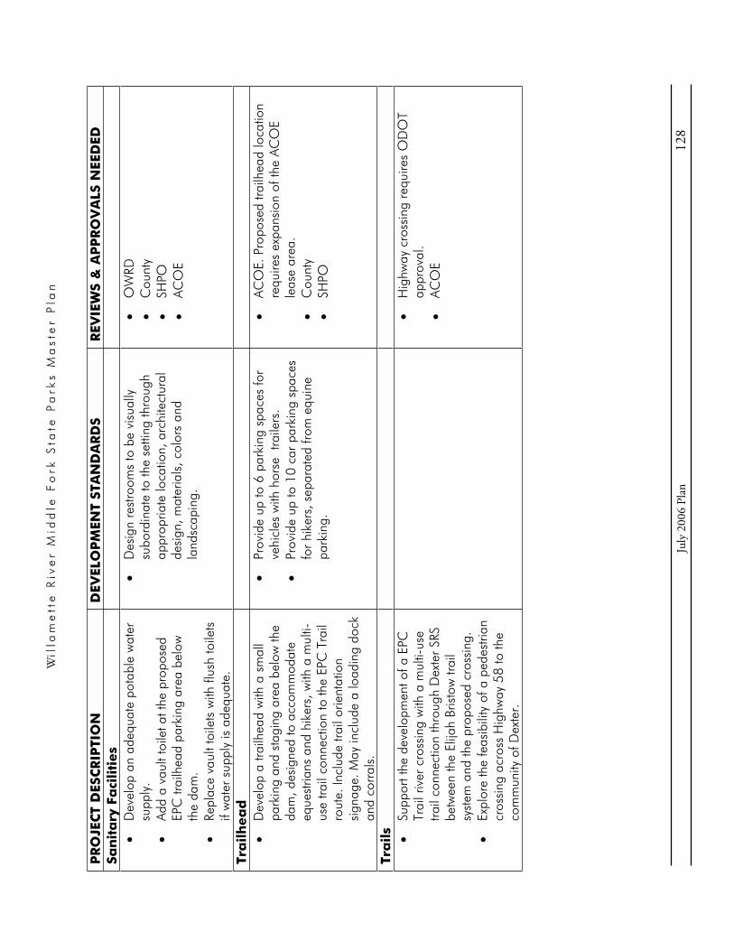
Wil
lam
ett
e R
ive
r M
idd
le F
ork
Sta
te P
ark
s M
ast
er
Pla
n
Ju
ly 2
006
Plan
12
8
PR
OJE
CT
DES
CR
IPTI
ON
D
EVEL
OP
MEN
T ST
AN
DA
RD
S R
EVIE
WS
& A
PP
RO
VA
LS N
EED
ED
San
ita
ry F
aci
liti
es
Dev
elop
an
adeq
uate
pot
able
wat
er
supp
ly.
Add
a va
ult t
oile
t at t
he p
ropo
sed
EPC
trai
lhea
d pa
rkin
g ar
ea b
elow
th
e da
m.
Repl
ace
vaul
t toi
lets
with
flus
h to
ilets
if
wat
er s
uppl
y is
ade
quat
e.
Des
ign
rest
room
s to
be
visu
ally
su
bord
inat
e to
the
setti
ng th
roug
h ap
prop
riate
loca
tion,
arc
hite
ctur
al
desi
gn, m
ater
ials
, col
ors
and
land
scap
ing.
OW
RDC
ount
ySH
POAC
OE
Tra
ilh
ea
dD
evel
op a
trai
lhea
d w
ith a
sm
all
park
ing
and
stag
ing
area
bel
ow th
e da
m, d
esig
ned
to a
ccom
mod
ate
eque
stria
ns a
nd h
iker
s, w
ith a
mul
ti-us
e tra
il co
nnec
tion
to th
e EP
C T
rail
rout
e. In
clud
e tra
il or
ient
atio
n si
gnag
e. M
ay in
clud
e a
load
ing
dock
an
d co
rral
s.
Prov
ide
up to
6 p
arki
ng s
pace
s fo
r ve
hicl
es w
ith h
orse
tra
ilers
. Pr
ovid
e up
to 1
0 ca
r pa
rkin
g sp
aces
fo
r hi
kers
, sep
arat
ed fr
om e
quin
e pa
rkin
g.
ACO
E. P
ropo
sed
trailh
ead
loca
tion
requ
ires
expa
nsio
n of
the
ACO
E le
ase
area
. C
ount
ySH
PO
Tra
ils
Supp
ort t
he d
evel
opm
ent o
f a E
PC
Trai
l riv
er c
ross
ing
with
a m
ulti-
use
trail
conn
ectio
n th
roug
h D
exte
r SR
S be
twee
n th
e El
ijah
Bris
tow
trai
l sy
stem
and
the
prop
osed
cro
ssin
g.
Expl
ore
the
feas
ibili
ty o
f a p
edes
trian
cr
ossi
ng a
cros
s H
ighw
ay 5
8 to
the
com
mun
ity o
f Dex
ter.
Hig
hway
cro
ssin
g re
quire
s O
DO
T ap
prov
al.
ACO
E

DEXTER
STATE RECREATION SITE
DEVELOPMENT CONCEPT
Boater Parking,Ramp, Boarding& Courtesy DocksExisting
RowersDockProposed
StageProposed
Host SiteRelocated
Way Finding SiteProposed
Park Office Proposed
ParkingRelocated
Overflow ParkingProposed
GroupShelterProposed
RestroomUpgraded
ParkingExisting
Highway 58
EPC TrailCrossingProposed
Dexte
r D
am
Fishing DockProposed
Park EntranceExisting
Revised May 2006
FoodConcessionProposed
Picnic/EventArea Expanded(ParkingRelocated)
Dexter Reservoir
Park Boundary
Pond
TrailExisting
Dexter
Elijah B
ristow
Equine ParkingProposed
TrailExisting
Disc Golf Course Redesign:Shaded areas roughly representareas that may be considered inretaining or relocating tee pads,baskets and fairways, subject toother requirements for redesignof the course described in thischapter.
HikerParkingProposed
TrailheadProposed
Vault ToiletProposed
N200’0

Wil
lam
ett
e R
ive
r M
idd
le F
ork
Sta
te P
ark
s M
ast
er
Pla
n
Ju
ly 2
006
Plan
13
1
Lowe
ll SR
S De
velo
pmen
t Pro
jects
PR
OJE
CT
DES
CR
IPTI
ON
D
EVEL
OP
MEN
T ST
AN
DA
RD
S R
EVIE
WS
& A
PP
RO
VA
LS N
EED
ED
Pa
rk E
ntr
an
ce R
oa
d
Relo
cate
the
entra
nce
road
slig
htly
to
the
east
to o
ptim
ize
spac
e fo
r da
y us
e pa
rkin
g, a
s ill
ustra
ted
on
conc
ept d
raw
ing.
Cou
nty
SHPO
ACO
E
Pic
nic
Are
a
Reta
in th
e cu
rren
t num
ber
of p
arki
ng
spac
es in
the
mai
n pa
rkin
g lo
t. Re
conf
igur
e th
e ro
ad a
nd p
arki
ng
alon
g th
e no
rth e
dge
of th
e pi
cnic
ar
ea to
opt
imiz
e sp
ace,
as
illus
trate
d on
con
cept
dra
win
g.
Rede
sign
and
des
igna
te th
e p
arki
ng
at th
e no
rth e
dge
of th
e pa
rk, a
nd
impr
ove
as n
eede
d.
Des
igna
te s
ome
park
ing
imm
edia
tely
ea
st o
f the
cre
ek a
s re
serv
eabl
e pa
rkin
g fo
r ro
win
g cl
ubs
and
othe
r gr
oups
. Re
mod
el th
e ex
istin
g gr
oup
picn
ic
shel
ter
for
all s
easo
n us
e, a
nd
expa
nd a
s ne
eded
. Re
desi
gn th
e pi
cnic
are
a in
the
oak
woo
dlan
d an
d sm
all m
eado
w in
a
man
ner
that
pro
tect
s th
e re
mna
nt
nativ
e pr
airie
pla
nt c
omm
uniti
es.
Inst
all s
igna
ge to
inte
rpre
t the
pla
nt
com
mun
ities
.
Des
igna
te u
p to
65
tota
l car
siz
e pa
rkin
g sp
aces
at t
he n
orth
edg
e of
th
e pa
rk b
etw
een
the
entra
nce
road
an
d th
e se
ason
al c
reek
. Of t
hese
, de
sign
ate
25 s
pace
s be
twee
n th
e pi
cnic
she
lter
and
the
seas
onal
cre
ek
as r
eser
veab
le p
arki
ng;
Inst
all a
gat
e se
para
ting
the
rese
rvea
ble
from
ot
her
park
ing.
D
esig
n th
e re
mod
eled
she
lter
to b
e op
en-s
ided
dur
ing
the
sum
mer
and
en
clos
ed d
urin
g th
e of
f-se
ason
. May
ha
ve a
sin
k an
d fir
epla
ce.
Shel
ter
will
be
visu
ally
sub
ordi
nate
to
the
setti
ng th
roug
h us
e of
ap
prop
riate
arc
hite
ctur
al d
esig
n,
mat
eria
ls, c
olor
s an
d la
ndsc
apin
g.
Inst
all v
isua
lly a
ttrac
tive
barr
iers
as
need
ed, a
nd in
terp
retiv
e si
gnag
e, to
pr
otec
t and
inte
rpre
t rem
nant
nat
ive
prai
rie p
lant
com
mun
ities
.
Cou
nty
SHPO
ACO
E
Fish
ing
Am
en
itie
s C
onst
ruct
a fi
shin
g do
ck w
ith tr
ail
acce
ss w
est o
f the
pic
nic
shel
ter.
D
SLAC
OE

Wil
lam
ett
e R
ive
r M
idd
le F
ork
Sta
te P
ark
s M
ast
er
Pla
n
Ju
ly 2
006
Plan
13
2
PR
OJE
CT
DES
CR
IPTI
ON
D
EVEL
OP
MEN
T ST
AN
DA
RD
S R
EVIE
WS
& A
PP
RO
VA
LS N
EED
ED
Con
stru
ct a
fish
cle
anin
g st
atio
n.
Cou
nty
SHPO
Row
ing
Fa
ciliti
es
Prov
ide
for
expa
nsio
n of
row
ing
club
bo
at a
nd e
quip
men
t sto
rage
and
st
agin
g at
the
exis
ting
boat
hou
se
site
wes
t of t
he c
reek
. C
onsi
der
inco
rpor
atin
g a
row
ers’
cl
ub h
ouse
into
a b
oat h
ouse
des
ign.
P
rovi
de fo
r ex
pans
ion
of th
e ro
win
g cr
ew d
ock,
incl
udin
g on
e or
two
addi
tiona
l doc
ks a
s ne
eded
.
Max
imum
exp
ansi
on o
f the
row
ing
stor
age
faci
litie
s w
ill b
e de
term
ined
by
site
lim
itatio
ns. T
he b
uild
able
are
a fo
r bo
at a
nd e
quip
men
t sto
rage
fa
cilit
ies
is d
efin
ed b
y th
e le
vel o
r ne
arly
leve
l gro
und
wes
t of t
he c
reek
, al
low
ing
for
requ
ired
setb
acks
from
th
e cr
eek,
the
lake
, and
Pen
gra
Road
R.
O.W
.Pl
ant t
rees
and
shr
ubs
alon
g th
e to
p of
the
bank
to h
elp
visu
ally
buf
fer
the
boat
hou
ses
as s
een
from
the
lake
.
Cou
nty
SHPO
DSL
ACO
EM
arin
e Bo
ard
Ma
rin
a Re
desi
gn th
e bo
at r
amp
with
ca
paci
ty c
omm
ensu
rate
with
boa
ter
vehi
cle
/ tra
iler
park
ing
capa
city
. Re
tain
the
exis
ting
num
ber
of b
oate
r ve
hicl
e pa
rkin
g sp
aces
.
DSL
ACO
EM
arin
e Bo
ard
Cou
nty
Food
Co
nce
ssio
n B
uil
din
g
Reha
b or
rep
lace
, and
exp
and,
the
food
con
cess
ion
build
ing.
Des
ign
with
indo
or a
nd o
utdo
or s
eatin
g.
Expl
ore
the
feas
ibili
ty o
f add
ing
an
uppe
r le
vel t
o th
e bu
ildin
g, fo
r us
e as
a
mee
ting
/ ga
ther
ing
spac
e ov
erlo
okin
g th
e m
arin
a.
Con
side
r in
clud
ing
a sm
all c
aret
aker
re
side
nce
in th
e bu
ildin
g de
sign
, to
repl
ace
the
exis
ting
host
RV
site
, if
need
ed fo
r se
curit
y at
the
mar
ina.
Build
ing
expa
nsio
n sh
ould
ext
end
east
, with
rel
ocat
ion
of th
e ho
st s
ite.
Build
ing
will
be
visu
ally
attr
activ
e th
roug
h us
e of
app
ropr
iate
ar
chite
ctur
al d
esig
n, m
ater
ials
, co
lors
and
land
scap
ing.
Bu
ildin
g m
ust m
eet C
ount
y la
kesh
ore
setb
ack
requ
irem
ents
.
Cou
nty
SHPO
ACO
E

Wil
lam
ett
e R
ive
r M
idd
le F
ork
Sta
te P
ark
s M
ast
er
Pla
n
Ju
ly 2
006
Plan
13
3
PR
OJE
CT
DES
CR
IPTI
ON
D
EVEL
OP
MEN
T ST
AN
DA
RD
S R
EVIE
WS
& A
PP
RO
VA
LS N
EED
ED
Ca
bin
Villa
ge o
r C
am
pg
rou
nd
D
evel
op a
cab
in v
illag
e in
the
east
ern
area
of t
he p
ark,
with
cen
tral
rest
room
and
sho
wer
bui
ldin
g, o
r w
ith in
divi
dual
bat
hroo
ms
and
kitc
hene
ttes.
Pro
vide
clu
ster
ed
park
ing
for
cabi
ns.
As a
n al
tern
ativ
e to
cab
ins,
dev
elop
a
smal
l cam
pgro
und.
Up
to 1
5 ca
bins
. May
be
slee
per
cabi
ns w
ith c
entra
l res
troom
and
sh
ower
bui
ldin
g, o
r de
luxe
cab
ins
with
bat
hroo
ms
and
kitc
hene
ttes.
Pr
ovid
e cl
uste
red
park
ing
for
up to
30
car
s, o
r 2
per
cabi
n.
Up
to 2
5 ca
mps
ites,
not
incl
udin
g ho
st s
ite, p
ossi
bly
with
full
serv
ice
hook
-ups
, if t
he c
ampg
roun
d al
tern
ativ
e is
cho
sen.
Pr
ovid
e a
300’
buf
fer
betw
een
the
east
par
k bo
unda
ry a
nd th
e ea
ster
n ex
tent
of t
he c
abin
vill
age
or
cam
pgro
und.
C
abin
s m
ust m
eet r
equi
red
setb
acks
fro
m th
e la
kesh
ore
and
Peng
ra R
oad
R.O
.W.
Do
not p
rovi
de b
oat t
raile
r pa
rkin
g at
cab
ins
or c
amps
ites.
City
of L
owel
l SH
POAC
OE.
Am
endm
ent t
o AC
OE
Man
agem
ent P
lan
need
ed.
Host
Sit
e
Relo
cate
the
host
site
. Dev
elop
one
or
mor
e ne
w h
ost s
ites
loca
ted
to
prov
ide
over
sigh
t of a
ll fa
cilit
ies
plan
ned
for
the
park
.
Prov
ide
full
serv
ice
hook
-ups
. Lo
cate
one
hos
t site
at t
he e
ntra
nce
to th
e ca
mpg
roun
d or
cab
in v
illag
e.
Cou
nty
SHPO
ACO
E
San
ita
ry F
aci
liti
es
Expl
ore
the
feas
ibili
ty o
f pro
vidi
ng
City
wat
er a
nd s
ewer
ser
vice
to th
e pa
rk.
As a
n al
tern
ativ
e to
obt
aini
ng c
ity
serv
ices
, upg
rade
the
park
’s w
ater
su
pply
sys
tem
and
con
tinue
usi
ng th
e
Loca
te d
ump
stat
ion
for
optim
um
traffi
c ci
rcul
atio
n an
d to
kee
p od
ors
at a
dis
tanc
e fro
m r
ecre
atio
n ar
eas.
Sc
reen
with
veg
etat
ion.
City
of L
owel
l AC
OE
Cou
nty
SHPO
For
park
faci
litie
s lo
cate
d ou
tsid
e of
th
e C
ity’s
exi
stin
g U
rban
Gro
wth

Wil
lam
ett
e R
ive
r M
idd
le F
ork
Sta
te P
ark
s M
ast
er
Pla
n
Ju
ly 2
006
Plan
13
4
PR
OJE
CT
DES
CR
IPTI
ON
D
EVEL
OP
MEN
T ST
AN
DA
RD
S R
EVIE
WS
& A
PP
RO
VA
LS N
EED
ED
exis
ting
park
sew
age
treat
men
t fa
cilit
y fo
r ex
istin
g an
d pl
anne
d pa
rk
deve
lopm
ent.
Wor
k w
ith th
e M
arin
e Bo
ard
and
expl
ore
the
need
for
a co
mbi
natio
n se
wag
e pu
mp
out a
nd d
ump
stat
ion.
Re
plac
e th
e po
rtabl
e to
ilet w
ith a
va
ult t
oile
t at t
he r
owin
g fa
cilit
ies
site
.
Boun
dary
(UG
B), C
ity s
ewer
and
w
ater
ser
vice
s m
ay b
e pr
ovid
ed o
nly
with
City
and
Cou
nty
appr
oval
of a
U
GB
expa
nsio
n th
at e
ncom
pass
es
the
park
faci
litie
s be
ing
serv
ed,
acco
mpa
nied
by
exce
ptio
ns to
st
atew
ide
Goa
ls 3
, 4 a
nd 1
1.
Tra
ils
Plan
for
deve
lopm
ent o
f the
EPC
Tr
ail a
long
Pen
gra
Road
, with
in th
e ro
ad r
ight
-of-
way
.

Park E
ntrance
Relocated
Restroom
Exis
tin
g
Pengra Road
Dexter R
eservoir
Boat R
am
p &
Boarding/Courtesy D
ock
Redesigned
Row
ers’ B
oat S
torage
Expanded
Sw
im
A
rea
Exis
tin
g
Row
ers’
Crew
D
ock
Expanded
Marina
Exis
tin
g
Food
Concession
Expanded
Fishing D
ock
Proposed
Picnic &
Play A
rea
Exis
tin
g
Group S
helter
Rem
odeled
Parking
Redesigned
Parking
Proposed
Picnic &
Play A
rea
Exis
tin
g
LOW
ELL
STATE RECREATION
SITE
DAY USE AREA
DEVELOPM
ENT CONCEPT
Host S
ites
Proposed
EPC T
rail
Proposed
Picnic A
rea
Redesigned
Pum
pout/D
um
p S
tation
Proposed
Revised M
ay 2
00
6
City Boundary City Boundary
Park
Boundary
Parking
Exis
tin
g
150’
0N

LOW
ELL
STATE RECREATION
SITE
CABIN ALTERNATIVE
DEVELOPM
ENT CONCEPT
Park E
ntrance
Relocated
Pengra Road
Cabins
Proposed
Park B
oundary
Dexter R
eservoir
Restroom
/S
how
er B
uilding
Proposed
EPC T
rail
Proposed
Host S
ite
Proposed
Sw
im
A
rea
Pum
pout/D
um
p S
tation
Proposed
Revised J
anuary 2
00
6
150’
0N

LOW
ELL
STATE RECREATION SITE
CAM
PGROUND
ALTERNATIVE
DEVELOPM
ENT CONCEPT
Park B
oundary
Park E
ntrance
Relocated
Self R
egistration
Proposed
Cam
pground
Proposed
EPC T
rail
Proposed
Sw
im
A
rea
Pengra Road
Dexter R
eservoir
Host S
ite
Proposed
Pum
pout/D
um
p S
tation
Proposed
Revised J
anuary 2
00
6
Restroom
Proposed
150’
0N

Wi l l a m e t t e R i v e r M i d d l e F o r k S t a t e P a r k s M a s t e r P l a n
July 2006 Plan 141
XII. DEVELOPMENT CONCEPTS FOR WINBERRY & NORTH SHORE PARKS
This chapter describes the existing conditions and proposed future development of Winberry and North Shore Parks, located on the shore of Fall Creek reservoir.
Setting and Character Winberry and North Shore Parks are located on opposite shores of the reservoir near the dam. The reservoir has 1820 acres of surface area at full pool, which inundates portions of two drainages, Winberry Creek and Fall Creek. The warm water temperature makes this reservoir particularly popular for power boating and related towing sports. Drawdown of the water level begins in mid-summer. By late summer, when the lake is reduced to a narrow channel, the only boat access is at North Shore’s low water ramp.
Winberry Park Winberry Park is located on the south shore. Access is from Winberry Creek Road. This day use park’s boating facilities, swim area and picnic area are heavily used when the reservoir is at or near full pool. Visitor activity reaches intensive levels on typical peak season weekends, when parking lots fill to capacity and many vehicles are turned away. The launch ramp becomes unusable once the reservoir pool is lowered by late summer. This park is forested except in areas developed and managed for recreational access and support facilities.
Size: Approximately 62 acres.
North Shore Park North Shore Park is located next to the dam on the north shore. Access to the park is from Big Fall Creek Road. This park’s low water boat ramp makes boating access possible throughout the year, although little activity occurs once the reservoir water level is reduced to low pool. During the summer the park absorbs some of the boater overflow from Winberry. Intensive use occurs on peak days, when designated parking spaces are filled and parking spills over into undesignated areas on the grass and along the roadside. About half of the park is forested, including some remnant oak woodland associations.
Size: Approximately 19 acres.
Resource Suitability The “Composite Suitability” maps in the Suitability Assessment chapter broadly illustrate the resource conditions within the parks, based on the resource assessments completed in the master planning process. Together with other resource information, these maps help guide OPRD in

Wi l l a m e t t e R i v e r M i d d l e F o r k S t a t e P a r k s M a s t e r P l a n
July 2006 Plan 142
determining which areas of the parks should be protected from intensive use and development, and areas where development and/or restoration may be considered.
Winberry Park Most of the undeveloped areas of this park are characterized by mid-age, common forest associations. A few small forest patches represent associations that are of conservation concern, including the two small forested wetlands.
North Shore Park Aside from the developed area, this park is a mix of oak woodlands and mixed forest associations with interspersed patches of exotic grasses and invasive species, and a few small areas dominated by native shrubs. The small patches of native forest and shrub associations that are of regional conservation concern comprise about half of the undeveloped area.

Wi l l a m e t t e R i v e r M i d d l e F o r k S t a t e P a r k s M a s t e r P l a n
July 2006 Plan 143
Existing Uses and Facilities The types and locations of existing park facilities are illustrated generally on the “Existing Ownership and Facilities” map included in this chapter. The table below lists the facilities.
Existing Recreation Uses
Existing Facilities
Winberry Park o Motor boating and related water sports
o Swimming
o Picnicking
Boat ramp, boarding dock and courtesy dockBoater vehicle/trailer parking lot with 90 vehicle/trailer size spaces, terraced in two sections to fit topography Mixed day use parking lot with 80 car size spaces and 40 boater vehicle/trailer size spaces Main waterfront picnic area Swim beach and swim dock Main restroom building with flush toilets Second waterfront day use parking area with 35 car size spaces and a vault toilet Fee booth Ranger residence Water supply from groundwater well On-site sewage disposal by septic and drainfield.Viewpoint pull-off near the dam
North Shore Park
o Motor boating and related water sports
o Minor picnicking & swimming
Two boat ramps, one extended for low water access Boater vehicle/trailer parking lot with 21 vehicle/trailer size spaces Small picnic area Vault toilet View point with capacity for16 cars No water supply

Wi l l a m e t t e R i v e r M i d d l e F o r k S t a t e P a r k s M a s t e r P l a n
July 2006 Plan 144
Park Issues, Opportunities, and Objectives
Park Issues & Opportunities Park Objectives
Both Parks
The reservoir is relatively small, and potentially overcrowded in relation to the existing supply of boater parking spaces at the parks. Currently, the ratio of reservoir area at full pool to total boater vehicle/trailer parking equates to 8 acres per boat.
Drawdown of the reservoir pool beginning in mid-summer limits the boating opportunities.
Interest in adding a floating restroom on the reservoir.
Avoid contributing to boat overcrowding on the reservoir. Retain the existing total supply of boater vehicle/trailer parking with no net increase for the reservoir overall. An increase in boat trailer spaces associated with proposed campground development at Winberry will be offset by elimination of the undesignated overflow boater vehicle/trailer parking at North Shore.
Work with the Marine Board and explore the need for a floating restroom on the reservoir.
Winberry
Boating demand far exceeds facility capacity, picnic areas are very popular, and many vehicles are turned away when parking spaces are full on peak days.
High demand, coupled with inefficient circulation at the launch ramp and parking lots, causes traffic congestion that backs up on the county road at peak times.
Need to redesign the entrance road, boat launch and parking areas for more efficient circulation.
Need to provide an efficient turn-around and exit route for vehicles that enter the park and find it full or closed.
Interest in adding camping facilities, for either general or group camping.
Interest in adding moorage for camper/boater use with development of a campground.
This park currently has no maintenance facilities. A central maintenance yard and
Retain the existing number of day use boater vehicle parking spaces.
Redesign the entrance road, boat launch area, and parking lot entrances as needed to improve circulation and efficiency.
Provide an efficient turn-around and exit route at the park entrance.
Work with the County to implement measures to reduce traffic congestion on the county road at the park entrance.
Develop a small campground. Consider design alternatives for general camping and group camping.
Consider adding boat moorage for campers in conjunction with campground development.
Expand opportunities for group picnicking with redesign of the picnic areas and additional car parking. Add one or more group picnic shelters.

Wi l l a m e t t e R i v e r M i d d l e F o r k S t a t e P a r k s M a s t e r P l a n
July 2006 Plan 145
Park Issues & Opportunities Park Objectives shop is needed to serve all of the parks on Fall Creek reservoir.
Interest in enhancing group day use opportunities with picnic area development and group shelters.
Interest in developing hiking trails.
Cultural resource investigation needed.
Interest in adding a seasonal food concession.
Develop a maintenance area to serve all of the parks on Fall Creek reservoir.
Relocate the ranger residence if needed in relation to redesigned park facilities.
Consider adding a seasonal food concession.
Add hiking trails.
Implement pertinent resource management guidelines discussed in Chapter XVI.
North Shore
Boating demand far exceeds facility capacity. On peak days when designated parking spaces are full, undesignated parking occurs on the grass and along the road, with as many as 50 vehicles parked in the undesignated areas. There is no gate controlling the entrance into the park, and no host to provide oversight.
High boating demand coupled with inefficient circulation causes traffic congestion.
Need to control undesignated overflow parking.
Moderately steep topography limits opportunities to expand the parking area.
Interest in improving the park for picnicking and general day use.
Interest in developing hiking trails.
Interest in restoring remnant oak woodlands.
At-risk species are known to use the shoreline habitat. Specific sites are unknown.
Unauthorized ORV use along the lakeshore and lake bed.
Retain the existing number of designated boater vehicle/trailer parking spaces.
Install barriers and signage as needed to control undesignated overflow parking.
Work with the County to implement measures to control overflow parking along the county road.
Redesign the boater parking for improved traffic circulation and efficiency.
Rehab boat ramps and add boarding floats.
Consider developing a picnic area with separate car parking east of the boater parking.
Explore options for improving the shoreline for swimming.
Explore options for controlling unauthorized ORV use.
Implement pertinent resource management guidelines discussed in Chapter XVI.
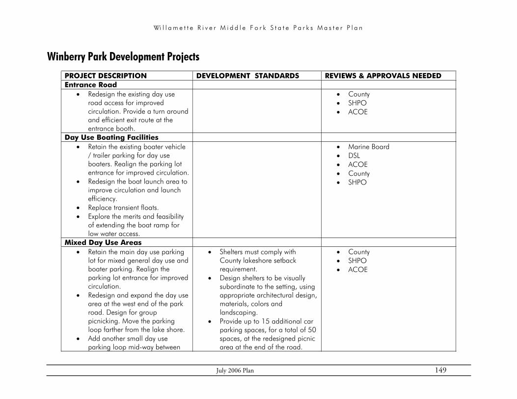
Wi l l a m e t t e R i v e r M i d d l e F o r k S t a t e P a r k s M a s t e r P l a n
July 2006 Plan 149
Winberry Park Development Projects
PROJECT DESCRIPTION DEVELOPMENT STANDARDS REVIEWS & APPROVALS NEEDED Entrance Road
Redesign the existing day use road access for improved circulation. Provide a turn around and efficient exit route at the entrance booth.
CountySHPOACOE
Day Use Boating Facilities Retain the existing boater vehicle / trailer parking for day use boaters. Realign the parking lot entrance for improved circulation.Redesign the boat launch area to improve circulation and launch efficiency. Replace transient floats. Explore the merits and feasibility of extending the boat ramp for low water access.
Marine Board DSLACOECountySHPO
Mixed Day Use Areas Retain the main day use parking lot for mixed general day use and boater parking. Realign the parking lot entrance for improved circulation. Redesign and expand the day use area at the west end of the park road. Design for group picnicking. Move the parking loop farther from the lake shore. Add another small day use parking loop mid-way between
Shelters must comply with County lakeshore setback requirement. Design shelters to be visually subordinate to the setting, using appropriate architectural design, materials, colors and landscaping. Provide up to 15 additional car parking spaces, for a total of 50 spaces, at the redesigned picnic area at the end of the road.
CountySHPOACOE

Wi l l a m e t t e R i v e r M i d d l e F o r k S t a t e P a r k s M a s t e r P l a n
July 2006 Plan 150
PROJECT DESCRIPTION DEVELOPMENT STANDARDS REVIEWS & APPROVALS NEEDED the main parking lot and the west picnic area. Add up to three group picnic shelters.
Provide up to 35 car parking spaces in the new day use parking loop.
CampgroundGeneral Camping Alternative
Develop a self registration campground east of the boating facilities. Some or all sites may be full hook-up sites. Include a restroom building, possibly with showers. Develop a separate access road from the county road to the campground. Provide one or two campground host sites. Provide adequate room in each campsite for one boat trailer. Alternatively, provide a separate boat trailer parking area in the campground area for exclusive camper boater use (not illustrated). Add moorage for use by registered campers.
Group Camp AlternativeAs an alternate campground design, develop a group camp area with two separate group camps available by reservation. Include a restroom building, possibly with showers.
General Camping AlternativeTotal campground capacity up to 30 individual campsites, not including host sites. Provide full hook-ups for host sites.Spaces for camper boat trailers not to exceed the number of campsites (one per site). Up to 30 maximum moorage slips for registered campers (one per site).
Group Camp AlternativeMaximum group camp capacity up to 120 people total for both camps. Provide full hook-ups for host sites.Up to 18 boat trailer parking spaces, total for both camps, for registered group camper use. Up to 18 moorage slips, total for both camps, for registered group camper use.
CountySHPOACOEDSLMarine Board

Wi l l a m e t t e R i v e r M i d d l e F o r k S t a t e P a r k s M a s t e r P l a n
July 2006 Plan 151
PROJECT DESCRIPTION DEVELOPMENT STANDARDS REVIEWS & APPROVALS NEEDED Develop a separate access road from the county road to the campground. Provide one or two campground host sites. Provide boat trailer parking for exclusive camper boater use. Add moorage for use by registered campers.
Maintenance Area Develop a maintenance area to serve all of the parks on Fall Creek reservoir, located west of the main park entrance road. Provide access to the maintenance area from the day use entrance road.
Size the maintenance yard and shop facilities to serve all of the Fall Creek reservoir parks. Include one or two staff office spaces in the shop building. Retain a wooded buffer around the maintenance area.
CountySHPOACOE
Ranger Residence Relocate the ranger residence as needed in relation to the new park design. Consider a minor relocation to the site illustrated on the concept drawing.
CountySHPOACOE
Food Concession Consider adding a seasonal food concession, located by the mixed day use parking lot.
May be permanent structure or space for mobile concession. (Space for mobile concession already exists.) Provide utilities, including sewer and water. Design to be visually subordinate to the setting through appropriate location,
CountySHPOACOE

Wi l l a m e t t e R i v e r M i d d l e F o r k S t a t e P a r k s M a s t e r P l a n
July 2006 Plan 152
PROJECT DESCRIPTION DEVELOPMENT STANDARDS REVIEWS & APPROVALS NEEDED design, materials, colors and landscaping.
Sanitary Facilities Add a restroom by the boat launch.Replace the restroom in the west day use area. Locate as appropriate for the new day use area design.
Restrooms must comply with County lakeshore setback requirement. Design restrooms to be visually subordinate to the setting, using appropriate architectural design, materials, colors and landscaping.
CountySHPOACOE
TrailsDevelop a hiking trail loop along the lake shore and around the west peninsula as illustrated.
CountySHPOACOE

200’
0N
Fall C
reek
Reservoir
Day U
se Parking
Expanded
Maintenance
Facilit
ies
Proposed
WINBERRY PARK
CAM
PGROUND ALTERNATIVE
DEVELOPM
ENT CONCEPT
Sw
im
D
ock
Exis
tin
g
Boat R
am
p,
Boarding &
Courtesy D
ocks
Exis
tin
g
Day U
se Parking
Proposed
Mixed
Day U
se Parking
Exis
tin
g
Restroom
Exis
tin
g
Restroom
Replaced
Group S
helters
Proposed
Boater Parking
Exis
tin
g
Restroom
Proposed
Ranger R
esidence
Relocated
Park E
ntrance
Redesigned
Trails
Proposed
Cam
per M
oorage
Proposed
Cam
pground
Proposed
Restroom
Proposed
Cam
pground
Entrance
Proposed
Group S
helter
Proposed
Winberry Creek R
oad
Food Concession
Proposed
Revised J
anuary 2
00
6

200’
0N
Fall C
reek
Reservoir
Day U
se Parking
Expanded
Maintenance
Facilit
ies
Proposed
WINBERRY PARK
GROUP CAM
P ALTERNATIVE
DEVELOPM
ENT CONCEPT
Sw
im
D
ock
Exis
tin
g
Boat R
am
p,
Boarding &
Courtesy D
ocks
Exis
tin
g
Day U
se Parking
Proposed
Mixed
Day U
se Parking
Exis
tin
g
Restroom
Exis
tin
g
Restroom
Replaced
Group S
helters
Proposed
Boater Parking
Exis
tin
g
Restroom
Proposed
Ranger R
esidence
Relocated
Park E
ntrance
Redesigned
Trails
Proposed
Cam
per M
oorage
Proposed
Group Cam
ps
Proposed
Restroom
s
Proposed
Cam
pground
Entrance
Proposed
Group S
helter
Proposed
Winberry Creek R
oad
Food Concession
Proposed
Revised J
anuary 2
00
6

Wi l l a m e t t e R i v e r M i d d l e F o r k S t a t e P a r k s M a s t e r P l a n
July 2006 Plan 157
North Shore Park Development Projects
PROJECT DESCRIPTION DEVELOPMENT STANDARDS REVIEWS & APPROVALS NEEDED
Boating Access Facilities Retain the existing number of designated boater vehicle parking spaces.Install boulders or bollards, and “no parking” signage, along the edges of the parking lot and access road to control undesignated overflow parking.Redesign the parking lot and boat ramp access as needed to improve circulation and efficiency. Explore the feasibility of consolidating the boat ramps into an improved 2-lane ramp that functions in high and low water conditions.Add boarding floats. Explore options for controlling unauthorized ORV use.
CountySHPOACOEDSLMarine Board
Picnic Area Retain the existing picnic area west of the boater parking, and expand if feasible with consolidation of the boat ramps.Consider improving the shoreline area for swimming, including a protective log boom. Consider developing a new picnic area east of the boater parking, with a separate car parking lot.
Significant grading may be needed to develop the new picnic area parking. Provide up to 20 car size parking spaces in the new parking lot. Install signage prohibiting boat trailer parking in the new parking lot.
CountySHPOACOEDSL

Wi l l a m e t t e R i v e r M i d d l e F o r k S t a t e P a r k s M a s t e r P l a n
July 2006 Plan 158
PROJECT DESCRIPTION DEVELOPMENT STANDARDS REVIEWS & APPROVALS NEEDED
Sanitary Facilities Replace the existing vault toilet as needed. Relocate as appropriate in relation to site redesign and picnic area expansion.
Restrooms must meet County lakeshore setback requirement. Design restroom to be visually subordinate to the setting through appropriate location, architectural design, materials, colors and landscaping.
CountySHPOACOE
TrailsConsider developing short hiking trails as illustrated.
CountySHPOACOE

N150’
0
NORTH SHORE PARK
DEVELOPM
ENT CONCEPT
Trails
Proposed
Park E
ntrance
Exis
tin
g
Picnic Parking
Proposed
Boater Parking
Redesigned
Fall Creek R
eservoir
Big F
all C
reek R
oad
Park Boundary
Park
Boundary
View
point Parking
Exis
tin
g
Sw
im
A
rea
Im
proved
(B
oat
Ram
p
Rem
oved) B
oat R
am
p
Im
proved
Boarding
Dock
Proposed
Picnic A
rea
Redesigned
Restroom
Relocated
Picnic A
rea
Proposed
Septem
ber 2
00
5

Wi l l a m e t t e R i v e r M i d d l e F o r k S t a t e P a r k s M a s t e r P l a n
July 2006 Plan 161
XIII. DEVELOPMENT CONCEPTS FOR SKY CAMP
This chapter describes the existing conditions and proposed future development at Sky Camp, located on the shore of Fall Creek reservoir.
Setting and Character Sky Camp’s primary purpose is to provide a youth camp outdoor recreation and learning experience. This purpose, and the park setting, are unique as compared to the other parks in the planning area. Sky Camp is located on the south shore of the Fall Creek arm of Fall Creek reservoir. Access is from Peninsula Road. By road, this location is more remote than the other parks. Only non-motorized recreation opportunities are offered at the park. The facilities are managed and operated by the Springfield School District, with the help of an on-site caretaker, under the guidance of a Board of Directors. First opportunities to reserve the lodge and group cabins are given to district student groups and other youth groups. When available, the facilities are also reserved by other groups for events such as family reunions, weddings, etc. Generally, the facilities are fully booked during the summer months. The operation is financially self-sustaining. The facilities and grounds are clustered at the west end of the park, leaving the larger forested area of the park generally undisturbed except by a hiking trail.
Size: Approximately 103 acres.
Resource Suitability The “Composite Suitability” maps in the Suitability Assessment chapter broadly illustrate the resource conditions within the parks, based on the resource assessments completed in the master planning process. Together with other resource information, these maps help guide OPRD in determining which areas of the parks should be protected from intensive use and development, and areas where development and/or restoration may be considered.
Most of Sky Camp is forested. More than half of the park is characterized by forest associations that are in excellent or good condition and of conservation concern. False brome, an invasive weed species that occurs along Peninsula Road, may pose a significant threat to the otherwise high quality forest habitat.

Wi l l a m e t t e R i v e r M i d d l e F o r k S t a t e P a r k s M a s t e r P l a n
July 2006 Plan 162
Existing Uses and Facilities The types and locations of existing park facilities are illustrated generally on the “Existing Ownership and Facilities” map included in this chapter. The table below lists the facilities.
Existing Recreation Uses Existing Facilities o Youth camp activities
o Swimming
o Canoeing
o Hiking
o Volleyball and other game sports
Large lodge. Seven group cabins, bunkhouse style. Two have restrooms and showers. One cabin sleeps 20 people, six cabins sleep 24 people each. Restroom and shower building. Managed grassy open space grounds used for tenting and various sports. Swim beach and canoe put-in. Boat house. Caretaker residence. Small shop. Hiking trail. Gravel parking areas with undefined capacity. Water supply from groundwater well. Sewage disposal by on-site septic and drain field.

Wi l l a m e t t e R i v e r M i d d l e F o r k S t a t e P a r k s M a s t e r P l a n
July 2006 Plan 163
Park Issues, Opportunities, and Objectives
Park Issues and Opportunities Park Objectives Interest in retaining the park’s primary purpose, recreation setting and experience for youth.
The existing bunkhouse style cabins and the lack of private showers limit the types of groups that are interested in renting the facilities.
Interest in exploring possible changes in the facilities and / or operations to cater to a wider range of visitor groups and interests, without changing the primary purpose, recreation setting and experience for youth.
Gradual drawdown of the reservoir pool during the summer limits the water-related recreation season.
Opportunity to add more group cabins within, or at the edge of, the existing developed recreation area.
The presence of false brome along Peninsula Road may threaten to degrade the high quality forest habitat.
Cultural resource investigation needed.
Preserve the primary purpose, recreation setting and experience for youth.
Conduct a market study and impact assessment to assess the merits of making changes in the existing park facilities, amenities or operations to attract a wider range of user groups, provided that the primary purpose, recreation setting and experience for youth are retained.
Explore the merits and feasibility of incorporating special accommodations for disabled youth, in addition to standard ADA requirements.
Consider remodeling the restroom / shower building to convert open showers to private showers.
Consider adding another cluster of group cabins, possibly with private bedrooms, provided that there are no detrimental affects on the youth camp experience.
Extend the hiking trail, preferably in a loop configuration.
Implement pertinent resource management guidelines discussed in Chapter XVI.

Wil
lam
ett
e R
ive
r M
idd
le F
ork
Sta
te P
ark
s M
ast
er
Pla
n
Ju
ly 2
006
Plan
16
7
Sky C
amp
Deve
lopm
ent P
roje
cts
PR
OJE
CT
DES
CR
IPTI
ON
D
EVEL
OP
MEN
T S
TAN
DA
RD
S R
EVIE
WS
& A
PP
RO
VA
LS N
EED
ED
Pa
rkin
g Con
side
r im
prov
ing
the
exis
ting
grav
el p
arki
ng
area
s w
ith d
esig
nate
d sp
aces
.D
efin
e an
are
a of
the
mea
dow
eas
t of t
he
entra
nce
road
for
over
flow
par
king
as
need
ed fo
r sp
ecia
l ev
ents
.
Impr
oved
par
king
cou
ld b
e pa
ved
or o
ther
sur
face
. Re
tain
the
gras
s su
rface
in
over
flow
par
king
are
as.
Coo
rdin
atio
n w
ith th
e sc
hool
dis
trict
and
Sky
Cam
p bo
ard.
ACO
ESH
PO
Gro
up
Ca
bin
s C
onsi
der
addi
ng a
new
gr
oup
cabi
n cl
uste
r,
loca
ted
alon
g th
e fo
rest
ed
ge n
ear
the
north
east
co
rner
of t
he m
eado
w.
New
cab
ins
may
hav
e a
cent
ral r
estro
om/s
how
er
build
ing.
Des
igna
te p
arki
ng fo
r th
e ne
w c
abin
s in
the
exis
ting
park
ing
lot n
ear
the
new
cab
in s
ite.
Con
side
r re
mod
elin
g th
e ex
istin
g re
stro
om /
sh
ower
bui
ldin
g,
conv
ertin
g th
e op
en
show
ers
to p
rivat
e sh
ower
s.
The
obje
ctiv
e is
to p
rese
rve
the
exis
ting
purp
oses
, prio
ritie
s,
recr
eatio
n se
tting
and
ex
perie
nce
for
yout
h. A
s su
ch,
sign
ifica
nt c
hang
es in
faci
litie
s or
ope
ratio
ns d
esig
ned
to
dive
rsify
rec
reat
iona
l use
s,
amen
ities
, rec
reat
ion
expe
rienc
e or
vis
itor
grou
ps w
ill b
e su
ppor
ted
by a
mar
ket
asse
ssm
ent a
nd im
pact
stu
dy.
This
req
uire
men
t will
app
ly to
pr
opos
ed n
ew c
abin
s an
d an
y si
gnifi
cant
cha
nges
to e
xist
ing
cabi
ns o
r ot
her
prim
ary
faci
litie
s.
Add
up to
7 c
abin
s in
the
new
cl
uste
r. M
ay b
e bu
nkho
use
styl
e,
or e
ach
may
hav
e up
to fi
ve
Cou
nty
appr
oval
of a
zon
e ch
ange
, fro
m “
Non
-im
pact
ed F
ores
tland
” (F
-1) z
one
to “
Impa
cted
Fo
rest
land
” (F
-2) z
one,
will
be
requ
ired
if in
divi
dual
ca
bins
hav
e pa
rtial
bat
hroo
ms
with
toile
ts a
nd s
inks
. C
ount
y ap
prov
al o
f a G
oal 4
exc
eptio
n w
ill b
e re
quire
d if
indi
vidu
al c
abin
s ha
ve fu
ll ba
thro
oms
or k
itche
ns.
Coo
rdin
atio
n w
ith th
e sc
hool
dis
trict
and
Sky
Cam
p bo
ard.
SHPO
ACO
E

Wil
lam
ett
e R
ive
r M
idd
le F
ork
Sta
te P
ark
s M
ast
er
Pla
n
Ju
ly 2
006
Plan
16
8
PR
OJE
CT
DES
CR
IPTI
ON
D
EVEL
OP
MEN
T S
TAN
DA
RD
S R
EVIE
WS
& A
PP
RO
VA
LS N
EED
ED
doub
le o
ccup
ancy
bed
room
s an
d a
cent
ral l
ivin
g ro
om.
As o
ne a
ltern
ativ
e, th
e ca
bin
clus
ter
may
hav
e a
sepa
rate
ce
ntra
l res
troom
and
sho
wer
bu
ildin
g. In
divi
dual
cab
ins
wou
ld h
ave
no p
lum
bing
. As
a s
econ
d al
tern
ativ
e,
indi
vidu
al c
abin
s m
ay h
ave
parti
al b
athr
oom
s w
ith to
ilets
an
d si
nks
but n
o sh
ower
s.
Show
ers
wou
ld b
e pr
ovid
ed in
a
sepa
rate
, cen
tral s
how
er
build
ing.
As a
third
alte
rnat
ive,
indi
vidu
al
cabi
ns m
ay h
ave
up to
two
bath
room
s w
ith to
ilets
and
sh
ower
s, a
nd m
ay a
lso
have
ki
tche
ns.
Lod
ge
Asse
ss th
e fu
nctio
nal
desi
gn a
nd o
pera
tion
of
the
lodg
e as
par
t of a
m
arke
t ass
essm
ent a
nd
impa
ct s
tudy
, and
co
nsid
er a
ny n
eede
d ch
ange
s ac
cord
ingl
y.
Any
chan
ges
in th
e lo
dge
will
be
cons
iste
nt w
ith th
e ob
ject
ive
of
pres
ervi
ng th
e ex
istin
g pu
rpos
es,
prio
ritie
s, r
ecre
atio
n se
tting
and
ex
perie
nce
for
yout
h.
Coo
rdin
atio
n w
ith th
e sc
hool
dis
trict
and
Sky
Cam
p bo
ard.
ACO
E
Ca
reta
ker
Resi
den
ce
Repl
ace
the
care
take
r re
side
nce
in th
e ex
istin
g lo
catio
n.
Cou
nty
SHPO
ACO
EW
ate
r Sp
ort
Am
en
itie
s Re
tain
the
exis
ting
wat
er
DSL
, AC
OE
and
Mar
ine
Boar
d ap
prov
al fo
r in
-wat
er

Wil
lam
ett
e R
ive
r M
idd
le F
ork
Sta
te P
ark
s M
ast
er
Pla
n
Ju
ly 2
006
Plan
16
9
PR
OJE
CT
DES
CR
IPTI
ON
D
EVEL
OP
MEN
T S
TAN
DA
RD
S R
EVIE
WS
& A
PP
RO
VA
LS N
EED
ED
spor
t act
iviti
es a
nd
faci
litie
s as
soci
ated
with
th
e yo
uth
cam
p, i.
e.,
swim
min
g an
d no
n-m
otor
ized
boa
ting.
C
onsi
der
addi
ng a
flo
atin
g sw
imm
ing
dock
. N
o m
otor
ized
boa
t la
unch
faci
litie
s w
ill b
e pr
ovid
ed. B
oat t
ie-u
ps o
r a
trans
ient
floa
t may
be
cons
ider
ed to
faci
litat
e pr
e-pl
anne
d m
otor
bo
atin
g ex
curs
ions
by
cam
p vi
sito
rs, p
rovi
ded
such
act
iviti
es d
o no
t de
tract
from
the
inte
nded
rec
reat
ion
setti
ng a
nd e
xper
ienc
e fo
r yo
uth.
stur
ctur
es.
Coo
rdin
atio
n w
ith th
e sc
hool
dis
trict
and
Sky
Cam
p bo
ard.
SHPO
ACO
E
Tra
ils
Exte
nd th
e ex
istin
g hi
king
tra
il ea
st o
f the
cam
p fa
cilit
ies
in a
loop
co
nfig
urat
ion.
Coo
rdin
atio
n w
ith th
e sc
hool
dis
trict
and
Sky
Cam
p bo
ard.
SHPO
ACO
ESp
eci
al A
ccom
mod
ati
on
s fo
r D
isa
ble
d Y
ou
th
As p
art o
f the
mar
ket
stud
y an
d im
pact
as
sess
men
t, ex
plor
e th
e m
erits
and
feas
ibili
ty o
f pr
ovid
ing
spec
ial
acco
mm
odat
ions
for
Coo
rdin
atio
n w
ith th
e sc
hool
dis
trict
and
Sky
Cam
p bo
ard.
ACO
E

Wil
lam
ett
e R
ive
r M
idd
le F
ork
Sta
te P
ark
s M
ast
er
Pla
n
Ju
ly 2
006
Plan
17
0
PR
OJE
CT
DES
CR
IPTI
ON
D
EVEL
OP
MEN
T S
TAN
DA
RD
S R
EVIE
WS
& A
PP
RO
VA
LS N
EED
ED
disa
bled
you
th, i
n ad
ditio
n to
sta
ndar
d AD
A re
quire
men
ts

200’
0
N
SKY CAM
P
DEVELOPM
ENT CONCEPT
Show
er B
uilding
Exis
tin
g
Group Cabins
Exis
tin
g
Group Cabins
Proposed
Lodge
Exis
tin
g
Overflow
Parking
on G
rass
Proposed
Shop
Exis
tin
g
Caretaker
Residence
Replaced
Parking
Im
proved
Parking
Im
proved
Canoe/E
quipm
ent
Storage B
uilding
Exis
tin
g
Play A
rea
Exis
tin
g
Fall Creek R
eservoir
Sw
im
A
rea &
Canoe Put-in
Exis
tin
g
Trails
Expanded
Peninsula Road
Septem
ber 2
00
5

Wi l l a m e t t e R i v e r M i d d l e F o r k S t a t e P a r k s M a s t e r P l a n
July 2006 Plan 173
XIV. DEVELOPMENT CONCEPTS FOR CASCARA CAMPGROUND, FISHERMAN’S POINT GROUP CAMP, FREE MEADOW, LAKESIDE 1 & 2
This chapter describes the existing conditions and proposed future development at Cascara Campground, Fisherman’s Point Group Camp, Free Meadow, Lakeside 1 and Lakeside 2, located on the shore of Fall Creek reservoir.
Setting and Character These parks are located at or near the upstream end of Fall Creek reservoir’s Fall Creek arm. This end of the reservoir is comparatively shallow and one of the first areas where boating and swimming access are affected by seasonal lowering of the reservoir pool.
Cascara Campground Cascara campground is located on the south shore of the Fall Creek arm near the Fall Creek inlet. This is currently the only park in the planning area that provides camping opportunities aside from Fisherman’s Point Group Camp. Access is from Peninsula Road. The campsites are regularly filled on weekends when the reservoir is at or near full pool. This is a popular campground for boaters and non-boaters. Typically about half of the campsites are occupied by boaters when the water level is up. The boat ramp and swim area become unusable as the reservoir pool is lowered, leaving the campground under-used by late summer. Park hosts provide seasonal oversight. Most of the park is developed with campground facilities and related recreation amenities. Mixed forest associations characterize the remaining portions of the park.
Size: Approximately 43 acres.
Fisherman’s Point Group Camp Fisherman’s Point Group Camp offers seasonal group camping opportunities by reservation. Access to the park is from Big Fall Creek Road. This park is very small, located between the road and Fall Creek at its inlet to the reservoir, about a quarter mile from Cascara Campground and immediately upstream from the bridge. Typically the group camp is fully booked for the summer weekends. There is no boat ramp. As the name suggests, this park is popular for fishing access.
Size: Approximately 8 acres.
Free Meadow Free Meadow is a small seasonal day use park on the north shore of the Fall Creek arm. From Big Fall Creek Road, a steep and narrow park access road descends to the small open meadow, boat

Wi l l a m e t t e R i v e r M i d d l e F o r k S t a t e P a r k s M a s t e r P l a n
July 2006 Plan 174
ramp and small gravel parking area. The steep road and inadequate turn-around and parking area discourage many boaters from using the boat launch. Aside from the meadow and developed areas, the park is characterized by mixed forest.
Size: Approximately 8 acres.
Lakeside One Lakeside One is located on the north shore of the Fall Creek arm across the water from Cascara Campground. Access is from Big Fall Creek Road. Most of this small seasonal day use park is developed for boating access and picnicking.
Size: Approximately 4 acres.
Lakeside Two Lakeside Two is located a short distance east of Lakeside One along the north shore of, and near end of, the Fall Creek arm. Access is from Big Fall Creek Road. This is the smallest of the parks in the planning area. Located within a narrow land area between the road and the lakeshore, this seasonal day use park has few trees. There is no boat launch at this park.
Size: Approximately 2 acres.
Resource Suitability The “Composite Suitability” maps in the Suitability Assessment chapter broadly illustrate the resource conditions within the parks, based on the resource assessments completed in the master planning process. Together with other resource information, these maps help guide OPRD in determining which areas of the parks should be protected from intensive use and development, and areas where development and/or restoration may be considered.
Cascara Campground The existing developed area occupies a large part of this park. About half of the remaining area consists of small patches of forest associations that are of conservation concern. A wetland forest occurs in the campground area.
Fisherman’s Point Group Camp The undeveloped area of the park consists of a mixed forest around the campground and along the stream. Blackberry patches also occur along the stream. A small native shrub association occurs at the southern end of the park at the water’s edge.
Free Meadow Forested areas at each end of the park consist of associations that are of conservation concern. A fringe of blackberries occurs along much of the waterfront.
Lakeside 1 Most of the park is developed for recreation. The plant associations are not of significant conservation value. Blackberry patches occur along much of the waterfront and at the northeast corner of the park.

Wi l l a m e t t e R i v e r M i d d l e F o r k S t a t e P a r k s M a s t e r P l a n
July 2006 Plan 175
Lakeside 2: Most of this park is also developed for recreation, and the plant associations are not of significant conservation value. Blackberries occur along much of the waterfront.
Existing Uses and Facilities The types and locations of existing park facilities are illustrated generally on the “Existing Ownership and Facilities” map included in this chapter. The table below lists the facilities.
Existing Uses Existing Facilities CascaraCampground
o Camping
o Motor boating and related water sports
o Swimming
47 primitive campsites, including six walk-in sites Swim area Boat ramp and boarding floats Small boat trailer parking area with capacity for 20 trailers. Campfire program area Open play area Vault toilets Water supply from groundwater well Host site Registration booth Tiny shop building
Fisherman’sPoint
o Group camping
o Fishing
Eight primitive group campsites that each accommodate up to eight campers Portable toilets Water supply from Cascara Campground groundwater well
Free Meadow o Minor motor boating
and related water sports
o Picnicking
Gravel boat ramp Small gravel parking area with capacity for 2 or 3 vehicles with trailers. Picnic area in meadow Portable toilets No water supply
Lakeside 1 o Motor boating and
related water sports
o Picnicking
o Swimming
Gravel boat ramp Two small gravel parking areas with capacity for 5 or 6 vehicles with trailers, or 12 vehicles without trailers. Two small picnic areas Portable toilets No water supply

Wi l l a m e t t e R i v e r M i d d l e F o r k S t a t e P a r k s M a s t e r P l a n
July 2006 Plan 176
Existing Uses Existing Facilities Lakeside 2 o Picnicking
o Swimming
Small gravel parking area with capacity for approximately 6 cars. Small picnic area Portable toilets No water supply
Park Issues, Opportunities, and Objectives
Park Issues & Opportunities Park Objectives
Cascara
The campground is popular while the water level is up, but the season of popularity is short due to drawdown of the reservoir pool. The boat ramp and swim area are unusable in the late summer.
Interest in extending the boat ramp for low water use, but probably not feasible.
Need for designated extra vehicle parking in the campground area.
Need to relocate the campfire program area.
Interest in providing flush toilets and showers.
Need to rehab the groundwater well.
At-risk species are known to use the shoreline habitat. Specific sites are unknown.
Designate areas for extra vehicle parking.
Designate parking spaces in the boat trailer parking area.
Consider providing flush toilets and showers in one restroom building.
Relocate the campfire program area.
Maintain the forested area between the campground and the road as a visual buffer.
Implement pertinent resource management guidelines discussed in Chapter XVI.
Fisherman’s Point
Desirable to replace portable toilets with vault toilets.
Erosion of the steep stream bank is apparent where campers tie boats at the shoreline.
Blackberry management needed along the stream.
At-risk species known to use the shoreline habitat. Specific sites unknown. Boating
Consider redesigning the camp loop in conjunction with rehab of the stream bank.
Replace portable toilets with vault toilets.
In cooperation with ACOE, ODFW, Lane County and the Marine Board, explore options for managing boating above the bridge to help promote recovery of at-risk species populations.

Wi l l a m e t t e R i v e r M i d d l e F o r k S t a t e P a r k s M a s t e r P l a n
July 2006 Plan 177
Park Issues & Opportunities Park Objectives upstream from the bridge may potentially disrupt the behavior of the affected species. A reduction in the population of the affected species at this location has been observed since the removal of a log boom that prevented boating upstream from the bridge.
Maintain the forested area between the road and the campground as a visual buffer.
Implement pertinent resource management guidelines discussed in Chapter XVI.
Free Meadow
Drawdown of the reservoir pool beginning mid-summer limits the boating season and use of the park.
The steep access road and inadequate turn-around and parking area discourages many boaters from using the boat launch.
Interest in developing the park for group camping.
No water supply.
Desirable to replace portable toilets with vault toilets.
Need to manage blackberries along the waterfront.
At-risk species are known to use the shoreline habitat. Specific sites are unknown.
Cultural resource investigation needed.
Consider converting to a group camp, available by reservation.
With group camp development, remove the boat ramp and replace with floats for boat-in access.
Replace portable toilets with vault toilets.
Implement pertinent resource management guidelines discussed in Chapter XVI.
Lakeside 1
Drawdown of the reservoir pool beginning mid-summer limits the boating season and use of the park.
The channel of Fall Creek is located near the north shore of the reservoir at this location. As such, water access may be more feasible, as compared to other parks, when the reservoir pool is lowered. There is some interest in extending the boat ramp for low water use.
Desirable to replace portable toilets with
Explore the merits and feasibility of extending the boat ramp for low water use.
Replace portable toilets with vault toilets.
Redesign the boater parking for improved circulation.
Implement pertinent resource management guidelines discussed in Chapter XVI.

Wi l l a m e t t e R i v e r M i d d l e F o r k S t a t e P a r k s M a s t e r P l a n
July 2006 Plan 178
Park Issues & Opportunities Park Objectives vault toilets.
Need to manage blackberries, especially along the waterfront.
At-risk species are known to use the shoreline habitat. Specific sites are unknown.
Cultural resource investigation needed.
Lakeside 2
Need to manage blackberries along the waterfront.
Desirable to replace portable toilets with vault toilets.
At-risk species are known to use the shoreline habitat. Specific sites are unknown.
Cultural resource investigation needed.
Replace portable toilets with vault toilets.
Implement pertinent resource management guidelines discussed in Chapter XVI.

Wil
lam
ett
e R
ive
r M
idd
le F
ork
Sta
te P
ark
s M
ast
er
Pla
n
Ju
ly 2
006
Plan
18
1
Casc
ara
Cam
pgro
und
Deve
lopm
ent P
roje
cts
PR
OJE
CT
DES
CR
IPTI
ON
D
EVEL
OP
MEN
T O
BJE
CTI
VES
& S
TAN
DA
RD
S R
EVIE
WS
& A
PP
RO
VA
LS
NEE
DED
Pa
rk R
oa
d
Expl
ore
the
need
for
min
or
real
ignm
ent o
f the
par
k ro
ad to
ac
com
mod
ate
larg
e ve
hicl
es.
SHPO
ACO
E
Pa
rkin
g Des
igna
te p
arki
ng fo
r ex
tra v
ehic
les
as il
lust
rate
d, a
nd im
prov
e as
ne
eded
, to
acco
mm
odat
e th
e ex
istin
g le
vel o
f use
.
Prov
ide
up to
20
addi
tiona
l ext
ra v
ehic
le s
pace
s as
ill
ustra
ted.
SH
POAC
OE
Boa
tin
g F
aci
liti
es
Des
igna
te p
arki
ng s
pace
s in
the
exis
ting
boat
trai
ler
park
ing
area
. M
arin
e Bo
ard
DSL
ACO
ESH
POC
am
pfi
re P
rog
ram
Are
a
Relo
cate
the
cam
pfire
pro
gram
are
a to
a s
uita
ble
loca
tion
away
from
the
park
ent
ranc
e ro
ad.
Loca
te a
nd d
esig
n to
min
imiz
e co
nflic
ts w
ith o
ther
ca
mpg
roun
d ac
tivity
. SH
POAC
OE
San
ita
ry F
aci
liti
es
Con
side
r pr
ovid
ing
flush
toile
ts a
nd
show
ers
in o
ne r
estro
om b
uild
ing.
Re
hab
the
grou
ndw
ater
wel
l.
Cou
nty
SHPO
ACO
E

200’
0N
Peni
nsul
a Ro
ad
Shop
Exis
ting
CASC
ARA
CAM
PGRO
UND
DEV
ELOPM
ENT
CONCE
PT
Swim
Are
aEx
isti
ng
Boat
Ram
p, &
Boa
rdin
g D
ock
Exis
ting
Extr
a Ve
hicl
ePa
rkin
gPr
opos
ed
Rest
room
sEx
isti
ng
Boat
Tra
iler
Park
ing
Exis
ting
Rest
room
sEx
isti
ng
Cam
pgro
und
Exis
ting
Cam
pgro
und
Entr
ance
Exis
ting
Wal
k-in
Cam
psit
esEx
isti
ng
Extr
a Ve
hicl
ePa
rkin
gEx
isti
ng
Wal
k-in
Cam
psit
ePa
rkin
gEx
isti
ng
Serv
ice
Road
Exis
ting
Fall
Cree
kRe
serv
oir
Park
Boun
dary
Cam
pfir
ePr
ogra
m A
rea
Relo
cate
d
Fall
Cree
kIn
let
Sept
embe
r 20
05

Wil
lam
ett
e R
ive
r M
idd
le F
ork
Sta
te P
ark
s M
ast
er
Pla
n
Ju
ly 2
006
Plan
18
5
Fish
erm
an’s
Poin
t Gro
up C
amp
Deve
lopm
ent P
roje
cts
PR
OJE
CT
DES
CR
IPTI
ON
D
EVEL
OP
MEN
T ST
AN
DA
RD
S R
EVIE
WS
& A
PP
RO
VA
LS
NEE
DED
Gro
up
Ca
mp
C
onsi
der
min
or r
edes
ign
of th
e gr
oup
cam
p lo
op, l
ocat
ing
all c
amps
ites
on
the
outs
ide
of th
e lo
op r
oad,
leav
ing
the
area
insi
de o
f the
loop
in o
pen
spac
e, a
s ill
ustra
ted.
Reta
in th
e cu
rren
t gro
up c
amp
capa
city
.
Cou
nty
SHPO
ACO
E
Boa
tin
g A
ccess
W
ork
with
AC
OE,
OD
FW, L
ane
Cou
nty
and
Mar
ine
Boar
d to
exp
lore
op
tions
for
man
agin
g bo
atin
g ab
ove
the
brid
ge, t
o he
lp p
rom
ote
reco
very
of
at-r
isk
spec
ies
popu
latio
ns.
If bo
at-in
acc
ess
to th
e ca
mpg
roun
d is
con
tinue
d, in
stal
l boa
t tie
s-up
s an
d ac
cess
trai
ls d
esig
ned
to d
irect
foot
tra
ffic
and
assi
st s
tream
ban
k re
habi
litat
ion.
AC
OE
OD
FWLa
ne C
ount
y M
arin
e Bo
ard
San
ita
ry F
aci
liti
es
Repl
ace
porta
ble
toile
ts w
ith v
ault
toile
ts.
Com
plia
nce
with
floo
dpla
in d
evel
opm
ent
requ
irem
ents
.D
esig
n an
d lo
cate
the
vaul
t toi
let t
o be
vis
ually
su
bord
inat
e to
the
setti
ng. U
se a
ppro
pria
te
arch
itect
ural
des
ign,
mat
eria
ls, c
olor
s an
d la
ndsc
apin
g.
Cou
nty
SHPO
ACO
E

FISHERMAN’S POINT
GROUP CAMP
DEVELOPMENT CONCEPT
Park
Entrance
Existing
Fall Creek
Restroom
Proposed
Group Camp
Redesigned
Park
Boundary
Park
Boundary
September 2005
150’0N

Wil
lam
ett
e R
ive
r M
idd
le F
ork
Sta
te P
ark
s M
ast
er
Pla
n
Ju
ly 2
006
Plan
18
9
Free
Mea
dow
Deve
lopm
ent P
roje
cts
PR
OJE
CT
DES
CR
IPTI
ON
D
EVEL
OP
MEN
T ST
AN
DA
RD
S R
EVIE
WS
& A
PP
RO
VA
LS
NEE
DED
Gro
up
Ten
t C
am
p
Rede
sign
the
mea
dow
and
par
king
ar
ea fo
r us
e as
a p
rimiti
ve g
roup
ca
mp
avai
labl
e by
res
erva
tion.
Re
desi
gn th
e pa
rkin
g to
opt
imiz
e sp
ace.
Des
ign
the
grou
p te
nt c
amp
with
a
cent
ral g
roup
cam
pfire
pit.
Max
imum
cap
acity
of 3
5 gr
oup
cam
pers
. M
axim
um o
f 10
car
park
ing
spac
es.
Cou
nty
SHPO
ACO
E
Boa
t A
ccess
Re
mov
e th
e bo
at r
amp
and
repl
ace
with
boa
t tie
-ups
and
boa
rdin
g flo
ats.
Tie-
ups
and
boar
ding
floa
ts fo
r m
axim
um o
f 5
boat
s.C
ount
ySH
POM
arin
e Bo
ard
DSL
ACO
ESa
nit
ary
Fa
ciliti
es
Repl
ace
porta
ble
toile
ts w
ith v
ault
toile
ts.
Gro
up c
ampe
rs n
eed
to b
ring
pota
ble
wat
er.
Des
ign
and
loca
te v
ault
toile
t bui
ldin
g to
be
visu
ally
sub
ordi
nate
to th
e se
tting
. Use
app
ropr
iate
ar
chite
ctur
al d
esig
n, m
ater
ials
col
ors
and
land
scap
ing.
Cou
nty
SHPO
ACO
E

FREE MEADOW
DEVELOPMENT CONCEPT
Parking
Redesigned
Park
Entrance
Existing
Fall C
reek R
eservoir
Restroom
Proposed
(Boat Ramp
Removed)
Group Tent Camp
Proposed
Boat Tie-ups/
Boarding Floats
Proposed
Big Fall
Creek Road
Park B
oundary
Park B
oundary
September 2005
N150’0

Wil
lam
ett
e R
ive
r M
idd
le F
ork
Sta
te P
ark
s M
ast
er
Pla
n
Ju
ly 2
006
Plan
19
3
Lake
side
1 De
velo
pmen
t Pro
jects
PR
OJE
CT
DES
CR
IPTI
ON
D
EVEL
OP
MEN
T ST
AN
DA
RD
S R
EVIE
WS
& A
PP
RO
VA
LS N
EED
ED
Pic
nic
Are
a
Reta
in th
e ex
istin
g pi
cnic
are
a an
d se
para
te p
arki
ng.
Boa
tin
g F
aci
liti
es
Expl
ore
the
mer
its a
nd fe
asib
ility
of
exte
ndin
g th
e bo
at r
amp
for
low
w
ater
use
. Re
desi
gn th
e bo
ater
veh
icle
/tra
iler
park
ing
for
impr
oved
circ
ulat
ion.
Max
imum
of 6
boa
ter
vehi
cle/
traile
r pa
rkin
g sp
aces
. M
arin
e Bo
ard
DSL
ACO
ESH
POC
ount
ySa
nit
ary
Fa
ciliti
es
Repl
ace
porta
ble
toile
ts w
ith v
ault
toile
ts.
Des
ign
the
vaul
t toi
let b
uild
ing
to b
e vi
sual
ly s
ubor
dina
te to
the
setti
ng.
Use
app
ropr
iate
arc
hite
ctur
al d
esig
n,
mat
eria
ls, c
olor
s an
d la
ndsc
apin
g.
SHPO
Cou
nty
ACO
E

LAKESIDE 1
DEVELOPMENT CONCEPT
Boater Parking
Redesigned
Park
Entrance
Existing
Fall C
reek R
ese
rvoir
Restroom
Proposed
Boat Ramp
Existing
Big Fall Creek Road
Picnic Parking
Existing
Park Boundary
Park Boundary
September 2005
N150’0

Wil
lam
ett
e R
ive
r M
idd
le F
ork
Sta
te P
ark
s M
ast
er
Pla
n
Ju
ly 2
006
Plan
19
7
Lake
side
2 De
velo
pmen
t Pro
jects
PR
OJE
CT
DES
CR
IPTI
ON
D
EVEL
OP
MEN
T ST
AN
DA
RD
S R
EVIE
WS
& A
PP
RO
VA
LS
NEE
DED
Pic
nic
Are
a
Reta
in th
e pi
cnic
are
a.
San
ita
ry F
aci
liti
es
Repl
ace
porta
ble
toile
ts w
ith v
ault
toile
ts.
Des
ign
the
vaul
t toi
let b
uild
ing
to b
e vi
sual
ly
subo
rdin
ate
to th
e se
tting
. Use
app
ropr
iate
ar
chite
ctur
al d
esig
n, m
ater
ials
, col
ors
and
land
scap
ing.
SHPO
Cou
nty
ACO
E

LAKESIDE 2
DEVELOPMENT CONCEPT
Park
Entrance
Existing
Fall C
reek R
eservoir
Restroom
Proposed
Big Fall Creek Road
Picnic Parking
Existing
Park
Boundary
Park
Boundary
September 2005
N150’0

Wi l l a m e t t e R i v e r M i d d l e F o r k S t a t e P a r k s M a s t e r P l a n
July 2006 Plan 201
XV. AREAS OF INTEREST In the master planning process, OPRD considers relationships between the state parks and neighboring properties to determine whether the other properties might be important for future recreational uses, for the protection of important resources, or for the protection of current or future uses in the state parks. Particularly important areas are called “areas of interest.” OPRD considers possible future land acquisitions, lease agreements, easements, and other mechanisms that are agreeable to OPRD and affected neighboring landowners. These actions are pursued only with willing landowners. The “areas of interest” that are under consideration in the planning area are discussed below.
Future Acquisition Interests OPRD is interested in possible future land acquisitions along the Middle Fork Willamette River that would contribute to the development and use of the Eugene to Pacific Crest Trail or the Willamette River Water Trail, or to the protection and management of the floodplain ecological resources, scenic qualities, or other primitive recreation opportunities associated with the Willamette Greenway. This master plan does not identify specific properties along the river that would be considered for acquisition from willing landowners.
Future ACOE Land Lease Interests Three sites that are under ACOE ownership are of interest to OPRD as possible future additions to the state park system through lease or other agreements. These three sites are identified on the “Middle Fork Willamette River Study Area” map in the “Planning Context” chapter.
Two sites, located on the shore of Fall Creek reservoir, are of interest for possible development for group camping. One of the sites is located adjacent to the west end of the Cascara Campground lease area. The second site is located on the north shore of the Fall Creek arm and across the water from the Sky Camp lease area.
The third site is located immediately downstream from the Fall Creek bridge, downstream from Fall Creek dam. This site is of interest for possible development as a portal to the Fall Creek reservoir parks. It is currently used for fishing and non-motorized boating access to Fall Creek.
In addition, minor changes to existing ACOE lease agreements may be needed to implement some of the recreation or resource management proposals described in this master plan.
Development Concepts for Future ACOE Lease Areas In cooperation with ACOE, OPRD will explore the merits and feasibility of developing and managing the potential lease areas described above, and proceed with development plans accordingly. OPRD will conduct initial scoping of site suitability with ACOE staff, and negotiate leases or other appropriate agreements. OPRD will conduct natural and cultural resource assessments

Wi l l a m e t t e R i v e r M i d d l e F o r k S t a t e P a r k s M a s t e r P l a n
July 2006 Plan 202
and formulate site plans for ACOE review. Necessary land use and development approvals will be obtained from Lane County.
The recreational use concepts as described herein for the potential lease areas are consistent with this master plan, provided they are designed to be compatible with the general goals, objectives, strategies and guidelines of this master plan, and subject to the following limitations:
2 Group Camp Sites Maximum of 35 people for each site.
Maximum of 10 car size parking spaces for each site. Alternatively, one or both sites may have boat-in access only.
No boat ramps.
Boat tie-ups and boarding floats for maximum of 5 boats for each site.
Important shoreline habitat identified in resource assessments will be protected by incorporating site design features that confine access to the water and shoreline along defined routes.
Sewage disposal by vault toilets.
Fall Creek Portal Site Maximum parking capacity: up to 7 car size spaces and up to 5 long spaces if feasible within site limitations.
May include vault toilet.

Wi l l a m e t t e R i v e r M i d d l e F o r k S t a t e P a r k s M a s t e r P l a n
July 2006 Plan 203
XVI. NATURAL, CULTURAL & SCENIC RESOURCE MANAGEMENT
This chapter outlines general guidelines for management of natural, cultural and scenic resources in the parks based on OPRD policies and statewide objectives, and on regional and park-specific issues identified in the master planning process.
NATURAL RESOURCE MANAGEMENT
Natural Resource Policy As stewards of the natural resources entrusted to the Oregon Parks and Recreation Commission, it shall be the policy of Oregon Parks and Recreation Department to:
1. Proactively manage the natural resource base for its contribution to the regional landscape, as well as, its function within a site specific planned landscape.
2. Actively cooperate and communicate with our public and private neighbors to promote compatible programs and practices.
3. Inform, involve and educate the public in significant planned management actions, including the scientific and practical aspects of current management techniques and strategies.
4. Consider the significant ecological, recreational and aesthetic qualities of our resources to be the highest priority.
5. Develop and follow management programs and action plans which exemplify excellence in resource stewardship, fulfill the agency mission, are guided by the management intent of our property classification system and meet or exceed federal, state and local laws and regulations.
Statewide Natural Resource Management Objectives OPRD’s natural resource management guidelines for state parks are based on system-wide objectives, on the detailed mapping of the vegetation, protected species and wildlife habitats completed for state park master plans, and on ecosystem patterns. A summary of the natural resource conditions in the planning area is included in the Heritage Assessment chapter. Detailed resource mapping for the planning area is available for viewing at the OPRD Salem headquarters office, or the OPRD South Willamette Management Unit office in Lowell.
The following objectives have been established by OPRD to guide natural resource management decisions for OPRD’s properties statewide. These general objectives were considered in combination

Wi l l a m e t t e R i v e r M i d d l e F o r k S t a t e P a r k s M a s t e r P l a n
July 2006 Plan 204
with the particular resource conditions in the planning area to determine specific objectives for the subject parks. The statewide objectives are:
1. Protect all existing high value, healthy, native Oregon ecosystems found within OPRD-managed properties. (Based on Oregon Natural Heritage ecosystem types and OPRD definition of high quality.)
a. Allow successional processes to proceed without intervention except as may be needed in particular circumstances.
b. Identify and monitor existing high quality ecosystems for the presence of threats to desired ecosystem types or conditions. Determine whether there are changes desired in ecosystem types or conditions based on consultation with Oregon Department of Fish and Wildlife, the Oregon Natural Heritage Program, the Oregon Department of Agriculture Protected Plants section, county resource groups and any applicable federal resource management agencies.
c. Manage the resources to eliminate any unacceptable threats or to attain desired ecosystem conditions and types.
d. Following a natural or human-caused catastrophic event, such as a major fire, wind throw, landslide or flooding; determine what management actions are needed, if any, to attain a desired ecosystem condition or type.
2. Where appropriate, restore or enhance existing low quality resource areas to a higher quality or desired ecosystem types or conditions based on consultation with natural resource agencies as to what a desired ecosystem should be for the planning area and for the region. Retain some low quality areas for future recreational use and development, as identified in the park master plan.
3. Manage all OPRD properties to protect existing occurrences of state or federally listed or candidate species to the approval of jurisdictional agencies:
a. Broaden species management plans into ecosystem management plans that include the monitoring and management of indicator species.
b. For selected lands, in consultation with natural resource regulatory agencies, determine how best to manage for protected species recovery and related desired ecosystem types and conditions.
4. Manage all OPRD lands and uses to minimize erosion, sedimentation, and other impacts on important resources.
5. Identify and acquire additional lands, or enter into management partnerships with landowners, to provide long term viability for important natural resources within OPRD-managed properties, as needed.
6. In areas of high quality ecosystems or habitats, endeavor to provide opportunities for the public to experience the following:
a. Sights, sounds, smells and feeling of ecosystems representative of Oregon and the region;
b. Understanding of the ecosystem structure, composition and function; c. Larger views of the landscape of which the ecosystem is a part.

Wi l l a m e t t e R i v e r M i d d l e F o r k S t a t e P a r k s M a s t e r P l a n
July 2006 Plan 205
7. In selected areas of low quality natural resources, manage for: a. Popular or attractive native plants or animals that are appropriate to the local
ecosystem;b. Desired views or settings; c. Desired cultural landscape restorations for interpretation.
8. Locate, design and construct facilities that provide public access to high quality ecosystems or habitats in a manner that avoids significant impacts on the ecosystems.
9. For those OPRD properties or sites which are historically significant and which have been identified by the Department as priority sites for emphasizing cultural resource protection, management and interpretation, manage the natural resources in the cultural resource areas to support cultural resource interpretation, unless this would result in unacceptable conflicts with protected species or areas of special natural resource concern.
10. Manage OPRD natural resources to protect visitors, staff, facilities and neighboring properties from harm.
11. Manage OPRD natural resources to protect them from threats from adjacent or nearby properties or their use.
12. Limit the use of non-native plants to developed facility areas or intensive use areas, and as is needed to withstand intensive use and to provide desired amenities such as shade, wind breaks, etc. Wherever possible, use native species in landscaping developed sites.
General Guidelines for Natural Resources in the Planning Area The following section generally describes OPRD’s objectives regarding future management and restoration of natural resources in the planning area parks. These objectives address forest management, oak woodlands, meadows, riparian areas, flood channels, wetlands, at-risk species, invasive species, previous damage from recreational uses, and existing restoration projects. Aerial photo maps that illustrate desired future ecosystem patterns in the parks are provided at the end of this chapter.
It is not the intent of this master plan to provide detailed prescriptions for management or restoration of the natural resources discussed in this chapter. Rather, the general guidance provided in this chapter will be used as a basis for formulating detailed management and/or restoration plans following the adoption of the master plan. Further analysis of resource conditions and consultation with experts will be needed to assess and refine the concepts described herein. Resource management plans that include specific restoration and management prescriptions will be developed on a priority basis. Such plans may be formatted to address specific issues, specific projects, or a range of issues and projects in individual parks or groups of parks.
Forest Management Forest associations that occur in the planning area are listed in Appendix A, “Native Plant Communities,” and are illustrated by the “Plant Communities and Conditions” maps prepared for

Wi l l a m e t t e R i v e r M i d d l e F o r k S t a t e P a r k s M a s t e r P l a n
July 2006 Plan 206
the Master Plan. Detailed descriptions of each plant association are provided in the ONHIC reports for the parks titled “Natural Resource Inventory for Natural Vegetation, At-Risk Species, and Other Fish and Wildlife Resources.”
Forested areas will require appropriate levels of on-going management to ensure that growth progresses toward a healthy, mature forest. The OPRD forester will prepare detailed plans for long term management of areas within the state parks. The management actions outlined in the forest management plans will address the following objectives:
Maintain a healthy forest structure and species composition over time.
Specific sites within the forest where views are desirable will require intensive management toward screened views through mature forest over time.
Developed recreation areas will require management to retain grassy open space with shade trees where desired and screening vegetation where needed. Hazard tree management will be needed to protect park visitors and facilities.
Any thinning operations in the parks will be planned to keep to a minimum the threat of windthrow.
Forest management will be planned to accomplish effective forest fire fuel control as needed.
The forest will be managed to retain an appropriate level of woody debris and snags for habitat.
Suitable habitat for at-risk species will be investigated to determine if such species are present. Where such species are identified, OPRD will consult with USFW and/or ODFW and follow any necessary management protocol in accordance with the requirements of state and federal Endangered Species Acts.
Oak Woodlands Native oak woodlands occur at Elijah Bristow, Dexter SRS, Pengra Access, Lowell SRS and North Shore Park. In most of these woodlands, the health of the oaks is declining and the species composition is changing, largely due to competition from conifer species that have thrived since the native American practice of management by fire was ceased, and naturally occurring fires have been suppressed. Because oak woodlands are gradually declining in geographic extent, they are generally regarded as habitats of regional conservation concern.
OPRD will strive to manage or restore remnant oak woodland associations where feasible. Management priorities may emphasize oak associations where the oaks still have a significant presence in the overstory composition, where management consists mainly of removing the competing overstory species and managing invasive understory shrubs.
OPRD will explore oak woodland restoration opportunities in suitable areas. Restoration efforts may emphasize areas that are located in and around remnant oak associations, and where exotic grasses or invasive shrubs are currently predominant. The “Ecosystem Management” maps in this chapter illustrate possible target areas for oak restoration. OPRD will seek partnerships with, and guidance from, interested agencies and organizations in pursuing restoration efforts.

Wi l l a m e t t e R i v e r M i d d l e F o r k S t a t e P a r k s M a s t e r P l a n
July 2006 Plan 207
MeadowsOpen meadows are important landscape features at Elijah Bristow State Park, for habitat diversity as well as scenic values. Currently, the meadow plant communities are predominantly exotic species.
Most of the existing meadows at Elijah Bristow will be retained as meadows, as illustrated on the “Ecosystem Management” maps for this park. With the help of interested agencies and organizations, OPRD will explore opportunities to establish native prairie or oak savanna habitat types in meadows, as appropriate for site conditions, to replace the exotic grasses and other non-native species. Native prairie and oak savanna habitats are of conservation concern statewide and regionally. There are no remaining examples of these habitat types in the planning area parks.
Riparian Areas Riparian habitats occur in all of the parks. Below Dexter dam, permanent surface water features, seasonal high water levels and occasional floods support mixed riparian forest communities along the river, tributary streams, ponds, sloughs, and frequently inundated flood channels. The geographic pattern and species composition of riparian communities have undergone gradual changes as a result of dam construction and resulting changes in floodplain hydrology.
Above the dams, seasonal streams with narrow riparian areas cut through several parks. Lakeshore riparian areas in these parks include a mix of native forest communities, as well as areas where development, reservoir operations and recreational use have substantially altered native habitats.
With limited exceptions, recreational facilities will be located to avoid riparian habitats. At the parks below Dexter dam, certain sections of new trails may be carefully developed through riparian forests. A few primitive walk-in campsites may be developed at the riparian forest edge near the Elijah Bristow picnic area. At the parks on the reservoirs, proposed development projects in riparian areas are water-dependent, requiring lakeshore locations. The proposed projects include rehab of existing boating access facilities at several parks, moorage facilities associated with campground development at Winberry, and possible boat-in access at sites where new group camps may be considered. These projects will be designed to minimize riparian impacts, and will comply with the related requirements of Lane County, DSL, ACOE and the Marine Board.
OPRD will manage native riparian habitats, using professionally accepted management practices, to protect habitat, water quality and floodwater detention functions. Removal of mature native trees, snags, and shrubs from viable riparian habitats will occur only as prescribed for purposes related to visitor safety or forest health. Snags and fallen trees will be left in place to benefit riparian and aquatic habitat, except as needed to remove obstructions or address safety concerns. Where trails are located to provide access to the water, they will be carefully designed and maintained to minimize impacts on riparian habitat and prevent erosion. Views from trails or other recreation use areas, as seen through riparian forests, may be maintained through careful pruning to remove lower tree limbs and maintain the height of understory shrubs.
OPRD will pursue partnerships with interested agencies and organizations to enhance or restore riparian habitats in areas where damage has resulted from past land use activities or invasive weeds, or otherwise where significant ecological benefits are likely to result from such projects.

Wi l l a m e t t e R i v e r M i d d l e F o r k S t a t e P a r k s M a s t e r P l a n
July 2006 Plan 208
Flood Channels The extent and frequency of flooding below the dams has been diminished since the dams were constructed. Numerous well-defined channels created by historic floods are less frequently inundated, but continue to absorb floodwaters in major flood events. Some of these channels and their functions were also altered by road-building or structural channelization of the river along certain river reaches. Elijah Bristow State Park has a significant number of historic flood channels.
Recent interests in restoring river floodplain functions have focused attention on Elijah Bristow as one of several high-priority restoration areas. The Army Corps of Engineers (ACOE), in partnership with ODFW and other stakeholders, is currently studying the feasibility of restoring floodplain functions at sites on the Willamette Middle and Coast Forks, including the possible restoration of flood channels at Elijah Bristow.
Historic flood channels will be treated similarly to active surface water channels. Existing native forests along these channels will protected and managed like the riparian forests of stream corridors, in order to retain habitat and floodwater detention functions.
OPRD will work with ACOE, ODFW and other stakeholders to identify and implement feasible projects for enhancing the ecological functions of historic flood channels. The findings of ACOE’s ecological restoration feasibility study for the Middle Fork (currently in progress), together with other pertinent information, will serve as a basis for assessing the feasibility of proposed restoration projects. In the design of such projects, OPRD will support restoration efforts that include changes in river discharges through modified dam operations, to the extent that these changes are compatible with other resource management and recreation objectives for the parks.
Wetlands A number of wetlands were identified in the resource assessments completed for the master plan. Probably, numerous other wetlands have not been accounted for, mostly due to their relatively small size or hidden locations in dense forested areas. The identified wetlands include wet meadows, shrub lands and forest communities. Known native wetland communities are identified as such on the “Ecosystem Management” maps in this chapter.
With limited exceptions, OPRD avoids wetlands when locating recreational facilities. The most common exceptions involve trail crossings and interpretive sites that rely on minor, and carefully designed, encroachment into wetland habitat. OPRD will abide by applicable regulatory requirements, and meet or exceed any applicable mitigation requirements, for any project involving wetland encroachment.
Some of the identified wetlands that occur along the river, streams, ponds and sloughs below Dexter dam, and along the shore of Fall Creek reservoir, are currently dominated by invasive weeds. At Pengra Access, a large wet meadow has remnant native wet prairie species mixed with the predominant exotic grasses.
OPRD will pursue partnerships with interested agencies and organizations to enhance or restore wetlands where invasive weeds threaten habitat values, or otherwise where significant ecological benefits are likely to be derived from such projects.

Wi l l a m e t t e R i v e r M i d d l e F o r k S t a t e P a r k s M a s t e r P l a n
July 2006 Plan 209
At-Risk Species Information on at-risk species was compiled from existing data sets provided by ONHIC, ODFW and ACOE. The specific locations of these species occurrences are not disclosed in this master plan, but have been incorporated into the master planning decisions.
OPRD will consult with ODFW and/or US Fish and Wildlife Service regarding any project within an area where at-risk species are known to occur, and follow any necessary management protocol in accordance with ESA requirements.
The following at-risk species have been identified in the planning area. The current listed status of each species is reported in the “Heritage Assessment” chapter.
Chinook salmon (Oncorhynchus tshawytscha): The river system is known to provide spawning and rearing habitat.
Oregon chub (Oregonichthys crameri): Certain ponds, sloughs and lakeshore areas are known to support populations of this species.
Western pond turtle (Clemmys marmorata): Various ponds, sloughs, lakeshore areas and adjacent riparian habitats are known to support populations of this species. Pond turtles are currently the subject of a monitoring program by ACOE, assisted by MFWWC and OPRD, involving sites at Elijah Bristow and Dexter. Actual and potential nesting sites have been identified at Elijah Bristow. OPRD has worked with ACOE and ODFW in the master planning process to identify potential conflicts between park proposals and turtle nesting. OPRD will continue to cooperate in the monitoring program, and continue to involve ACOE and ODFW in the implementation of planned park projects and management activities to avoid or mitigate potential conflicts.
Red-legged frog (Rana aurora): At least one pond in the planning area is known to support a population of this species, which likely also occurs at other similar water features in the planning area.
Bald eagle (Haliaeetus leucocephalus): One, and possibly two, pairs nest in the planning area vicinity and include certain park lands within their territories.
Pileated woodpecker (Dryocopus pileatus): This species has been seen recently in at least two of the parks.
Thin-leaved pea vine (Lathyrus holochlorus): This is the only at-risk plant species identified in the planning area. It is known to occur at one site.
Invasive Species Invasive non-native plants pose one of the most immediate threats to natural resource conditions at the parks. Numerous problem areas were identified as part of the ONHIC inventory of plant communities and conditions. Large sites where invasive plants are predominant are represented on the “Ecosystem Management” maps included at the end of this chapter. These sites are identified by species name on the “Plant Communities and Conditions” maps prepared as background information for the master plan. In addition, the ONHIC reports for the parks (titled “Natural Resource Inventory for Natural Vegetation, At-Risk Species, and Other Fish and Wildlife

Wi l l a m e t t e R i v e r M i d d l e F o r k S t a t e P a r k s M a s t e r P l a n
July 2006 Plan 210
Resources”) contain references to invasive plants that occur in the species composition of numerous plant associations.
Control of invasive plants will be of paramount importance in the development and implementation of natural resource management plans for the parks. OPRD will pursue partnerships with interested agencies and organizations to prioritize, manage, and restore where feasible, areas where invasive plant species have been identified. Such projects will be prioritized based on the relative threat, project feasibility, potential for ecological benefit, and available funding.
The following invasive non-native plants were identified in the inventory of plant communities and conditions:
Japanese knotweed: Sites where this species is known to occur, along Lost Creek and the river, were too small to map. These sites have been the subject of an eradication program through the cooperative efforts of OPRD, ODA, the Middle Fork Willamette Watershed Council, and other landowners and land managers in the watershed.
Himalayan blackberry: A number of sites where blackberry is the dominant species were mapped, including sites in nearly all of the parks. Blackberry also occurs in the species composition of numerous plant associations in all of the parks.
Scotch broom: This shrub occurs as a dominant species at several mapped sites at Dexter SRS, Elijah Bristow, Lakeside 1 and North Shore. It also occurs in the species composition of plant associations in all of the parks.
Reed canary grass: This species occurs extensively along the shoreline of Fall Creek reservoir, much more so than is represented by the mapping for the parks on this reservoir. It was mapped as the dominant species at several sites along the river at Elijah Bristow, and also occurs in the species composition of numerous plant associations in wet areas at all of the parks below Dexter dam.
English Ivy: This species was identified in the species composition of various plant associations in several parks.
False brome: Although this species was not mentioned in the ONHIC reports, there are large infestations at Elijah Bristow, and it also occurs along the road bordering Sky Camp.
Several non-native fish and wildlife species also occur in the parks and surrounding area, some of which threaten the survival of at-risk species. The Oregon chub is threatened by predation and competition from several species, such as largemouth bass. Western pond turtles and red-legged frogs are threatened by predation from bullfrogs. In managing at-risk species habitats, OPRD will work closely with ODFW to identify and implement strategies to control predation and competition from invasive fish and wildlife.
Natural Resource Damage from Recreational Uses Certain sites in the parks are showing signs of heavy recreational use, indicating a need to change the patterns of use and rehabilitate affected areas.
At Elijah Bristow, certain segments of the multiple use trail system pass through low-lying wet areas that occur along permanent or seasonal water courses. The impact of constant heavy use over wet soils causes a maintenance burden. In a few areas, this also creates the potential for sedimentation of

Wi l l a m e t t e R i v e r M i d d l e F o r k S t a t e P a r k s M a s t e r P l a n
July 2006 Plan 211
important surface water bodies or damage to important wetland plant communities, such as along Lost Creek. OPRD is working with equestrian groups to identify, rehabilitate and manage affected sites, including structural trail improvements where needed. OPRD will formulate a trail management plan to address the on-going maintenance and improvement of the trail system.
At Dexter, damage to native vegetation has resulted from heavy use of the disc golf course in certain areas. In the worst of these areas, the ground has been denuded of vegetation, soils are compacted, and tree trunks are scarred from being hit by flying discs. OPRD will work with the Eugene Disc Golf Club to redesign the course as needed to prevent significant damage. Redesign of the course will be accompanied by a management plan that specifies measures for minimizing impacts to natural resources and for rehabilitating damaged areas .
At Fisherman’s Point Group Camp, damage to the stream bank and adjacent riparian habitat has occurred as a result of informal boat-in access and related foot traffic at the shoreline. OPRD will explore options for designating trails to redirect traffic, and for re-vegetating and stabilizing damaged areas. If boat-in access is continued, OPRD will design and construct the access to prevent significant riparian impacts. Boat-in access to the group camp may be discontinued if needed to address at-risk species concerns.
Existing Restoration Projects Several natural resource restoration projects are in various stages of implementation. These sites have been avoided in choosing the locations of planned recreational facilities.
At Elijah Bristow, the Middle Fork Willamette Watershed Council (MFWWC) is implementing a 27-acre habitat restoration project involving native plantings at the Lost Creek confluence in partnership with OPRD. Three acres have been planted, and planning for the remaining 24 acres is underway with the help of funding secured through an OWEB grant.
Other habitat enhancement projects at Elijah Bristow have focused on riparian plantings and weed control along Lost Creek and several ponds and sloughs occupied by at-risk species. Additionally, a project near the entrance to this park has been underway to improve the health of a native oak stand and restore native grasslands used by ground nesting birds.
Efforts to restore native riparian habitat have also been on-going at Jasper, along the south river bank and at the west end of the picnic area.
OPRD will continue to support existing restoration projects by avoiding conflicts in the siting, design and management of recreation uses and facilities.
Concepts for Future Ecosystem Management Included at the end of this chapter are geographic illustrations that depict, conceptually, the desired future ecosystem pattern for each of the parks. These maps are titled “Ecosystem Management.” In part, the desired ecosystem patterns depicted by these maps are based on the background mapping and reports on existing plant community types and conditions, pre-settlement vegetation patterns, and management recommendations, provided by the ONHIC. The ONHIC recommendations

Wi l l a m e t t e R i v e r M i d d l e F o r k S t a t e P a r k s M a s t e r P l a n
July 2006 Plan 212
were considered together with OPRD’s objectives for natural resource management and recreation uses at the parks.
Natural resource management concepts and methods for the parks are intended to be adaptive, to respond to new and better information that becomes available. The ecosystem management concepts depicted by the maps in this chapter are generalized, based on currently available information. More detailed and accurate information on resource conditions and restoration feasibility is being produced by interested agencies and organizations. The new information will enable refinement of the concepts in this document and development of more detailed plans for resource management and restoration.
SCENIC RESOURCE MANAGEMENT There is no formal policy on scenic resource management in state parks except for general guidance provided by OPRD’s mission statement and OPRD’s recreation setting definitions developed for the Statewide Comprehensive Outdoor Recreation Plan. The recreation setting definitions are applied in the master plan assessments. The department has a long history of exploring opportunities to acquire or establish agreements regarding the management of properties for scenic enjoyment, and continues that tradition in its management actions.
River Views Views of the river from key viewpoints along riverfront trails at Elijah Bristow and Jasper should be maintained by careful pruning of the lower limbs of trees and maintaining the height of understory vegetation.
Impacts on views of the riverbank, from the perspective of boats on the river, will be avoided in the siting and design of buildings and other structures. Lane County’s Willamette Greenway policies and ordinances require a minimum building setback of 100 feet from the ordinary high water line.
Lake Views Views of the lakes from key viewpoints along lakeshore trails should also be maintained by careful pruning of the lower limbs of trees and maintaining the height of understory vegetation.
Structural development at the parks on Dexter and Fall Creek reservoirs will be located and designed to avoid or mitigate impacts on important lake views from recreation areas, and views of the parks from the lake surface. This is particularly important in locating and designing the proposed group shelter and stage at Dexter, in the rehabilitation and expansion of the Nexus Grill at Lowell, and in locating and designing the proposed cabins at Lowell. At Sky Camp, the proposed new group cabins will be located so that a forested buffer screens the view of the cabins from the perspective of the lake surface. Special consideration will be given to the architectural design, materials, colors and landscaping of these buildings.
Meadow Views Most existing meadows at Elijah Bristow will retained, and restored with native plant communities if feasible, as illustrated by the “Ecosystem Management” maps for this park. Most of these meadows

Wi l l a m e t t e R i v e r M i d d l e F o r k S t a t e P a r k s M a s t e r P l a n
July 2006 Plan 213
are important for their scenic qualities as viewed from the park road and trail system, in addition to their importance for habitat diversity.
CULTURAL RESOURCE MANAGEMENT There is a high likelihood of discovering artifacts in several of the parks. Sites where such discoveries are likely were identified in the master planning process. In order to prevent possible looting, this information is not disclosed to the general public. Prior to the construction of any of the facilities proposed in this master plan, consultation with the State Historic Preservation Office (SHPO) is required to assure that such areas are either being avoided or are investigated prior to, and monitored during, construction activities.

Wi l l a m e t t e R i v e r M i d d l e F o r k S t a t e P a r k s M a s t e r P l a n
July 2006 Plan 231
XVII. SUMMARY OF LAND USE APPROVAL REQUIREMENTS
Development of the park uses and facilities described in this master plan is governed by Lane County and the City of Lowell within their respective land use jurisdictions and under the provisions of their comprehensive plans. The County and City comprehensive plans are acknowledged by the Land Conservation and Development Commission (LCDC) pursuant to the statewide land use goals, statutes and related administrative rules.
This master plan has been formulated through the master planning process described under OAR 736 Division 18 and OAR 660 Division 34. The master planning process includes procedures for coordinating with affected local governments to assure that the park master plan is compatible with the local government comprehensive plans.
Land Use Approval of the Master Plan Land use approval of the state park master plan by an affected local government is required unless all of the planned state park projects are compatible with the existing comprehensive plan and ordinance provisions. “Compatible” means that development permits may be approved for all of the planned park projects within the affected local government jurisdiction without first amending the local government’s comprehensive plan or ordinance.
Development Permits for State Park Projects Development permits are required for most of the projects described in the master plan. Prior to beginning construction of any project, the project manager is responsible for consulting with the affected local government planning department and obtaining the necessary development permits. The specific requirements for obtaining development permits for a project, and the kind of local permitting process required, may vary from one project to another. The time required for completing the development permitting process may also vary, therefore, the project manager should consult with the local government planning department early enough to assure that the permitting process is completed prior to the target date for beginning construction. Prior to issuance of development permits for a project, the local government will review the project plans and specifications to assure that the project proposed for construction is consistent with the design concept and description of the project in the park master plan and with any applicable development standards in the local government’s development ordinances.
Variations from the Master Plan Under the provisions of OAR 736-018-0040, OPRD may pursue development permits for a state park project that varies from a state park master plan without first amending the master plan provided that the variation is minor, unless the master plan language specifically precludes such variation. Any specific project design elements that cannot be changed by applying the “Minor Variation” rule are indicated in the design standards for the projects in the master plan.

Wi l l a m e t t e R i v e r M i d d l e F o r k S t a t e P a r k s M a s t e r P l a n
July 2006 Plan 232
The OPRD Director must determine that a proposed variation from the master plan is “minor” using the criteria in OAR 736-018-0040. A minor variation from the master plan, which is approved by the Director, is considered to be consistent with the master plan, contingent upon the concurrence of the affected local government.
Rehabilitation of Existing State Park Uses State laws allow OPRD to continue any state park use or facility that existed on July 25, 1997. (See ORS 195.125 and OAR 660-034-0030(8).) The laws allow the repair and renovation of facilities, the replacement of facilities including minor location changes, and the minor expansion of uses and facilities. Rehabilitation projects are allowed whether or not they are described in a state park master plan. These projects are subject to any clear and objective siting standards required by the affected local government, provided that such standards do not preclude the projects.
Prior to applying for development permits for a project involving a minor location change of an existing facility or minor expansion of an existing use or facility, the OPRD Director must determine that the location change or expansion is “minor” using the criteria in OAR 736-018-0043. A determination by the Director that a proposed location change or expansion is minor is contingent upon the concurrence of the affected local government.

Wi l l a m e t t e R i v e r M i d d l e F o r k S t a t e P a r k s M a s t e r P l a n
July 2006 Plan 233
APPENDIX ANATIVE PLANT ASSOCIATIONS Native Plant Associations at Jasper SRS
Black cottonwood - bigleaf maple / snowberry (Populus balsamifera ssp. trichocarpa - Acermacrophyllum / Symphoricarpos albus)- Total acreage: approx. 35.7 - Habitat type: Westside riparian. - Condition rank 3. Non-native species abundant. - Conservation status: Statewide rank 3, “uncommon.” Floodplain riparian association of regional conservation concern.
Oregon ash - black cottonwood / redosier dogwood (Fraxinus latifolia - Populus balsamifera ssp. trichocarpa / Cornus sericea)- Total acreage: approx. 3.1 - Habitat type: Westside riparian. - Condition rank 3. Non-native species abundant. - Conservation status: Statewide rank 4, “secure.” Regionally common association, but of conservation concern due to floodplain riparian location.
Black cottonwood / Himalayan blackberry – Scot’s broom (Populus balsamifera ssp. trichocarpa / Rubus discolor - Cytisus scoparius)- Total acreage: approx. 4.2 - Habitat type: Westside riparian. - Condition rank 3. Non-native species abundant. - Conservation status: No statewide rank. Cottonwood overstory is of conservation concern along the river bank.
Native Plant Associations at Unnamed WRG Parcel
Red Alder - Oregon ash (Alnus rubra - Fraxinus latifolia)- Total acreage: approx. 2.3 - Habitat type: Westside riparian. - Condition rank 2. Fairly young, but dominated by native species. - Conservation status: No statewide rank. Of regional conservation concern due to floodplain riparian location.
Black cottonwood – Red alder (Populus balsamifera ssp. trichcocarpha – Alnus rubra / Symporicarpos albus / Urtica doicoia)- Total acreage: approx. 0.7 - Habitat type: Westside riparian.

Wi l l a m e t t e R i v e r M i d d l e F o r k S t a t e P a r k s M a s t e r P l a n
July 2006 Plan 234
- Condition rank 2. Fairly mature overstory, native species dominant, minor presence of non-natives.- Conservation status: Statewide rank 4, “secure.” Of regional conservation concern due to floodplain riparian location.
Black cottonwood-Oregon ash (Populus balsamifera ssp. trichcocarpha - Fraxinus latifolia / Urtica doicoia)- Total acreage: approx. 3.0 - Habitat type: Westside riparian. - Condition rank 2. Mature overstory, native species dominant, minor presence of non-natives. - Conservation status: Statewide rank 3, “uncommon.” Of regional conservation concern due to floodplain riparian location.
Black cottonwood / Pacific willow (Populus balsamifera ssp. trichcocarpha / Salix lucida ssp. lasiandra)- Total acreage: approx. 2.6 - Habitat type: Westside riparian. - Condition rank 2. Mature overstory, native species dominant, minor presence of non-natives. - Conservation status: Statewide rank 3, “uncommon.” Floodplain riparian association of regional conservation concern.
River Willow gravelbar (Salix fluviatilis)- Total acreage: approx. 1.7 - Habitat type: Westside riparian. - Condition rank 2. Dominated by natives, and despite significant presence of non-natives, is in the best condition that is typical of this naturally disturbed community. - Conservation status: Statewide rank 4, “secure.” Of regional conservation concern due to floodplain riparian location.
Sitka willow – Scouler willow (Salix sitchensis – Salix scouleri)- Total acreage: approx. 0.4 - Habitat type: Westside Riparian. - Condition rank 2. Dominated by natives, minor presence of non-natives. - Conservation status: Statewide rank 3, “Uncommon.” Of regional conservation concern due to floodplain riparian location.
Native Plant Associations at Green Island Landing
Red alder/River willow (Alnus rubra / Salix lutea ssp. lasiandra)- Total acreage: approx. 2.2 - Habitat type: Westside Riparian. - Condition rank 2 Dominated by natives, minor presence of non-natives.- Conservation status: No statewide rank. Of regional conservation concern due to floodplain riparian location.

Wi l l a m e t t e R i v e r M i d d l e F o r k S t a t e P a r k s M a s t e r P l a n
July 2006 Plan 235
Oregon ash (Fraxinus latifolia / Lolium arundinaceae)- Total acreage: approx. 2.7 - Habitat type: Westside Riparian. - Condition rank 3. Previously disturbed, with largely non-native understory. - Conservation status: No statewide rank. Of regional conservation concern due to floodplain riparian location.
Black cottonwood - Oregon ash / Snowberry (Fraxinus latifolia – Populus balsamifera ssp. trichocarpa/ Symphoricarpos albus)- Total acreage: approx. 29.1 - Habitat type: Westside riparian. - Condition rank 2. Dominated by natives, minor presence of non-natives. - Conservation status: Statewide rank 4, “secure.” Of regional conservation concern due to floodplain riparian location.
Black cottonwood - Oregon ash / Hazel (Populus balsamifera ssp. trichocarpa / Corylus cornuta)- Total acreage: approx. 15.6 - Habitat type: Westside Riparian. - Condition rank 2. Dominated by natives, minor presence of non-natives. - Conservation status: No statewide rank. Of regional conservation concern due to floodplain riparian location.
Pacific willow (Salix lucida ssp. lasiandra)- Total acreage: approx. 0.5 - Habitat type: Westside riparian. - Condition rank 2. Dominated by native species. - Conservation status: Statewide rank 4, “secure.” Of regional conservation concern due to floodplain riparian location.
Sitka willow-Scouler willow (Salix sitchensis-Salix scouleriana)- Total acreage: approx. 0.4 - Habitat type: Westside riparian. - Condition rank 2. Dominated by native species, minor presence of non-natives. - Conservation status: Statewide rank 4, “secure.” Of regional conservation concern due to floodplain riparian location.
River willow gravelbar (Salix fluviatilis)- Total acreage: approx. 4.4 - Habitat type: Westside Riparian. - Condition rank 2. Dominated by native species, minor presence of non-natives. - Conservation status: Statewide rank 3, “uncommon.” Of regional conservation concern due to floodplain riparian location.

Wi l l a m e t t e R i v e r M i d d l e F o r k S t a t e P a r k s M a s t e r P l a n
July 2006 Plan 236
Native Plant Associations at Elijah Bristow, Pengra Access and Dexter SRS
Grand fir-Bigleaf maple/Vine maple-hazel (Abies grandis-Acer macrophyllum/Acer circinatum-Corylus cornuta)Occurs at Elijah Bristow. - Total acreage: approx. 133.3 - Habitat type: Westside Riparian. - Condition rank 2. Dominated by native species, minor presence of non-natives. - Conservation status: Statewide rank 2, “imperiled.” Of regional conservation concern due to floodplain riparian location.
Grand fir-Bigleaf maple/Vine maple-hazel Forest (Abies grandis-Acer macrophyllum/Acer circinatum-Corylus cornuta) (This is a disturbed example of the plant community discussed above.) Occurs at Elijah Bristow and Pengra Access. - Total acreage: approx. 91.5 - Habitat type: Westside Riparian. - Condition rank 3. Much of this forest is poorly developed and has a high cover of non-native species.- Conservation status: Statewide rank 2, “imperiled.” Of regional conservation concern due to floodplain riparian location.
Bigleaf maple-Douglas fir Forest (Acer macrophyllum-Pseudotsuga menziesii/Acer circinatum-Corylus cornuta)Occurs at Pengra Access - Total acreage: approx. 27.6 - Habitat type: Westside Riparian. - Condition rank 3. Poorly developed forest with high cover of non-native species. - Conservation status: No statewide rank. Of regional conservation concern only where it occurs along the riverbank.
Bigleaf maple-Red Alder Forest (Acer macrophyllum-Alnus rubra/Rubus discolor)Occurs at Pengra Access. - Total acreage: approx. 0.7 - Habitat type: Westside Riparian. - Condition rank 3. High cover of non-native species. - Conservation status: No statewide rank. Of regional conservation concern only because it occurs along the riverbank.
Bigleaf maple-Oregon Ash / Snowberry (Acer macrophyllum-Fraxinus latifolia / Symphoricarpos albus)Occurs at Elijah Bristow. - Total acreage: approx. 16.5 - Habitat type: Westside Riparian. - Condition rank 2. Dominated by native species, minor presence of non-natives. - Conservation status: No statewide rank. Of regional conservation concern due to floodplain riparian location.

Wi l l a m e t t e R i v e r M i d d l e F o r k S t a t e P a r k s M a s t e r P l a n
July 2006 Plan 237
Bigleaf maple-Black Cottonwood / Snowberry Forest (Acer macrophyllum-Populus balsamifera ssp. trichocarpa / Symphoricarpos albus) Occurs at Elijah Bristow. - Total acreage: approx. 15.9 - Habitat type: Westside Riparian. - Condition rank 2. Dominated by native species, minor presence of non-natives. - Conservation status: Statewide rank 4, “secure.” Of regional conservation concern due to floodplain riparian location.
Bigleaf maple-Black Cottonwood / Snowberry Forest (Acer macrophyllum-Populus balsamifera ssp. trichocarpa / Symphoricarpos albus) (This is a disturbed example of the plant community discussed above.)Occurs between Elijah Bristow and Dexter. - Total acreage: approx. 6.1 - Habitat type: Westside Riparian. - Condition rank 3.- Conservation status: Statewide rank 4, “secure.” Overstory is of regional conservation concern due to floodplain riparian location.
Bigleaf maple-Douglas fir / Snowberry Forest (Acer macrophyllum-Pseudotsuga menziesii/Symphoricarpos albus)Occurs at Elijah Bristow and Dexter. - Total acreage: approx. 157.2 - Habitat type: Westside Riparian. - Condition rank 3.- Conservation status: Statewide rank 4, “secure.” Of regional conservation concern due to floodplain riparian location.
Bigleaf maple-Western Red Cedar / Swordfern (Acer macrophyllum-Thuja plicata/Polystichum munitum)Occurs at Elijah Bristow. - Total acreage: approx. 153.1 - Habitat type: Westside Riparian - Condition rank 3. Diverse native species composition, but fairly young with significant presence of non-natives.- Conservation status: No statewide rank, but probably a variant of the Acer macrophyllum – Thuja plicata / Oemleria cerasiformis) type, which is ranked 2, “imperiled.” Of regional conservation concern due to riparian floodplain location.
Oregon ash-Bigleaf maple/Stinging Nettle Forest (Fraxinus latifolia-Acer macrophyllum/Urtica doicia)Occurs at Elijah Bristow. - Total acreage: approx. 1.1 - Habitat type: Westside Riparian. - Condition rank 3. High cover of non-native species. - Conservation status: No statewide rank. Not of regional conservation concern.
Oregon ash / Himalayan blackberry Forest (Fraxinus latifolia/Rubus discolor)

Wi l l a m e t t e R i v e r M i d d l e F o r k S t a t e P a r k s M a s t e r P l a n
July 2006 Plan 238
Occurs at Elijah Bristow. - Total acreage: approx. 0.5 - Habitat type: Westside Riparian. - Condition rank 3. High cover of non-native species. - Conservation status: Statewide rank 5, “secure.” Not of regional conservation concern.
Big leaf maple – Western red cedar / Indian plum Forest (Acer macrophyllum – Thuja plicata/Oemelaria cerasiformis)Occurs at Elijah Bristow. - Total acreage: approx. 1.3 - Habitat type: Westside Riparian - Condition rank 3. Diverse native species composition, but fairly young with significant presence of non-natives.- Conservation status: No statewide rank. Of regional conservation concern due to floodplain riparian location.
Black Cottonwood-Douglas fir/Scots broom (Populus balsamifera ssp. trichocarpa – Pseudotsuga menziesii / Cytisus scoparius)Occurs at Elijah Bristow. - Total acreage: approx. 1.2 - Habitat type: Westside Riparian. - Condition rank 3. High cover of non-native species. - Conservation status: Statewide rank 5, “secure.” Overstory is of conservation concern because it occurs along on river bank.
Black Cottonwood/Willow Forest (Populus balsamifera ssp. trichocarpa/Salix lutea ssp. lasiandra)Occurs at Elijah Bristow. - Total acreage: approx. 5.8 - Habitat type: Westside Riparian. - Condition rank 3. High cover of non-native species. - Conservation status: No statewide rank, but similar to Populus balsamifera ssp. trichocarpa/Salix lutea ssp. Caudate, which is ranked 2. Of conservation concern due to floodplain riparian location.
Black Cottonwood/Willow Forest (Populus balsamifera ssp. trichocarpa/Salix lutea ssp. lasiandra)(This a younger example of the forest type described above.) Occurs at Elijah Bristow. - Total acreage: approx. 1.1 - Habitat type: Westside Riparian. - Condition rank 3. Fairly young with significant presence of non-native species. - Conservation status: No statewide rank, but similar to Populus balsamifera ssp. trichocarpa/Salix lutea ssp. Caudate, which is ranked 2. Of conservation concern due to floodplain riparian location.
Douglas fir/swordfern (Pseudotsuga menziesii/Polystichum munitum)Occurs at Elijah Bristow. - Total acreage: approx. 1.5 - Habitat type: Westside Riparian. - Condition rank 3. High cover of non-native species.

Wi l l a m e t t e R i v e r M i d d l e F o r k S t a t e P a r k s M a s t e r P l a n
July 2006 Plan 239
- Conservation status: No statewide rank. Lacking a developed native shrub understory, but otherwise similar to the Pseudotsuga menziesii/Corylus cornuta-Symphoricarpos mollis/Polystichum munitum type, which is ranked 3. Overstory is of conservation concern due to floodplain riparian location.
Oregon white oak-Bigleaf Maple-Douglas fir Forest (Quercus garryana-Acer macrocarpum-Pseudotsuga menziesii)Occurs at Dexter. - Total acreage: approx. 14.3 - Habitat type: Westside Oak. - Condition rank 3. High cover of non-native species. - Conservation status: No statewide rank. Oak woodlands are of regional conservation concern.
Oregon white oak/Himalayan blackberry-Snowberry (Quercus garryana / Rubus discolor-Symphoricarpos albus) . A disturbed variant of (Quercus garryana/Symphoricarpos albus/Polystichum munitum).Occurs at Pengra Access and Elijah Bristow. - Total acreage: approx. 8.3 - Habitat type: Westside Oak. - Condition rank 3. High cover of non-native species. - Conservation status: Statewide rank 5, “secure.” Oak woodlands are of regional conservation concern.
Oregon white oak/Poison oak-Snowberry (Quercus garryana / Toxicodenron diversifolia-Symphoricarpos albus)Occurs at Pengra Access. - Total acreage: approx. 2.0 - Habitat type: Westside Oak. - Condition rank 2. Predominantly native species. - Conservation status: Statewide rank 1, “Imperiled.” Oak woodlands are of regional conservation concern.
Oregon white oak/Poison oak-Snowberry (Quercus garryana / Toxicodenron diversifolia-Symphoricarpos albus) (This is a weedy example of the type discussed above.)Occurs at Dexter. - Total acreage: approx. 4.5 - Habitat type: Westside Oak. - Condition rank 3. High cover of non-native species. - Conservation status: Statewide rank 1, “Imperiled.” Oak woodlands are of regional conservation concern.
Oregon white oak-bigleaf maple-Douglas fir Forest (Quercus garryana – Acer macrophyllum –Pseudotsuga menziesii)Occurs at Elijah Bristow. - Total acreage: approx. 41.5 - Habitat type: Westside Oak. - Condition rank 3. High cover of non-native species. - Conservation status: No statewide rank. Oak woodlands are of regional conservation concern.

Wi l l a m e t t e R i v e r M i d d l e F o r k S t a t e P a r k s M a s t e r P l a n
July 2006 Plan 240
Oregon white oak-Oregon ash/Snowberry (Quercus garryana – Fraxinus latifolia /Symphoricarpos albus)Occurs at Elijah Bristow. - Total acreage: approx. 0.5 - Habitat type: Westside Oak. - Condition rank 3. High cover of non-native species. - Conservation status: No statewide rank. Not of regional conservation concern due to small size and location.
Western red cedar – Red alder (Thuja plicata – Alnus rubra / Rubus spectabilis / Oxalis oregana)Occurs at Pengra Access. - Total acreage: approx. 1.0 - Habitat type: Westside riparian. - Condition rank 3. High cover of non-native species. - Conservation status: Statewide rank 2, “imperiled.” Of regional conservation concern due to floodplain riparian location.
River willow Gravelbar (Salix fluviatilis)Occurs at Elijah Bristow. - Total acreage: approx. 1.6 - Habitat type: River channel. - Condition rank 2. Predominantly native species. - Conservation status: Statewide rank 4, “secure.” Of regional conservation concern due to river channel location.
Tufted hairgrass-tall fescue grassland (Deschampsia cespitosa – Lolium arundinaceae)Occurs at Pengra Access. - Total acreage: 51.4 - Habitat type: Wet meadow. - Condition rank 3. Predominantly non-native species. - Conservation status: No statewide rank due to high cover of exotics, although tufted hairgrass wet prairies are ranked 2, “imperiled.” Wet meadows are of regional conservation concern.
Native Plant Associations at Lowell SRS Douglas fir / Himalayan blackberry (Pseudotsuga menziesii / Rubus discolor)- Total acreage: approx. 5.5 - Habitat Type: Westside Douglas Fir. - Condition rank 3. High cover of non-native species. - Conservation status: No statewide rank due to high cover of exotics. Not of regional conservation concern.
Oregon white oak – Douglas-fir – ponderosa pine / snowberry (Quercus garryana – Pseudotsuga menziesii – Pinus ponderosa / Symphoricapos albus).- Total acreage: approx. 3.3 - Habitat type: Westside Oak.

Wi l l a m e t t e R i v e r M i d d l e F o r k S t a t e P a r k s M a s t e r P l a n
July 2006 Plan 241
- Condition rank 3. High cover of non-native species. - Conservation status: Statewide rank 4, “secure,” for Douglas fir – Oregon oak / snowberry. Statewide rank 3, “uncommon,” for Ponderosa pine – Oregon oak / snowberry. Oak woodlands are of regional conservation concern.
Douglas-fir – Oregon white oak / poison oak (Pseudotsuga menziesii – Quercus garryana / Toxicodendron diversilobum).- Total acreage: approx. 2.6 - Habitat type: Westside Oak. - Condition rank 3. High cover of non-native species. - Conservation status: No statewide rank. Not of regional conservation concern.
Oregon white oak / Idaho fescue (Quercus garryana / Festuca idahoensis var. roemeri savanna)- Total acreage: approx. 1.7 - Habitat type: Westside Oak. - Condition rank 3. Disturbed site with high cover of non-native species. - Conservation status: Statewide rank 1, “imperiled.” Oak woodlands are of regional conservation concern.
Native Plant Associations at Fall Creek Reservoir Parks
Grand fir-Western Hemlock/Swordfern Forest (Abies grandis-Tsuga heterophylla/Polystichum munitum)Occurs at Winberry and Sky Camp. - Total acreage: approx. 11.9 - Habitat type: Westside Douglas Fir. - Condition rank 2. Dominated by native species. - Conservation status: Statewide rank 2, “imperiled.” Of regional conservation concern due to rareness.
Bigleaf maple-Red Alder Forest (Acer macrophyllum-Alnus rubra/Polystichum munitum)Occurs at Sky Camp. - Total acreage: approx. 7.7 - Wildlife Habitat: Westside Riparian. - Condition rank 2. Dominated by native species. - Conservation status: No statewide rank. Of regional conservation concern due to rarity and stream riparian location.
Bigleaf maple-Black Cottonwood / Snowberry Forest (Acer macrophyllum-Populus balsamifera ssp. trichocarpa / Symphoricarpos albus)Occurs at Winberry. - Total acreage: approx. 0.1 - Habitat type: Westside Riparian. - Condition rank 3. Previously disturbed site with significant presence of non-native species. - Conservation status: Statewide rank 4, “secure.” Not of regional conservation concern.

Wi l l a m e t t e R i v e r M i d d l e F o r k S t a t e P a r k s M a s t e r P l a n
July 2006 Plan 242
Bigleaf maple - Douglas fir - Black cottonwood / Swordfern Forest (Acer macrophyllum - Pseudotsuga menziesii - Populus balsamifera ssp. trichocarpa / Polystichum munitum)Occurs at North Shore, Lakeside 1 and 2, and Cascara Campground. - Total acreage: approx. 17.1 - Habitat type: Westside Riparian. - Condition rank 3. Previously disturbed site with significant presence of non-native species. - Conservation status: No statewide rank. Not of regional conservation concern.
Bigleaf maple-Douglas fir/Vine maple Forest (Acer macrophyllum-Pseudotsuga menziesii/Acer circinatum/Polystichum munitum)Occurs at Fisherman Point, Cascara, Lakeside 2, Sky Camp, and Winberry. - Total acreage: approx. 57.5 - Habitat type: Westside Riparian. - Condition rank 3. Previously disturbed site with significant presence of non-native species. - Conservation status: Statewide rank 4, “secure.” Not of regional conservation concern.
Red Alder / Swordfern (Alnus rubra / Polystichum munitum)Occurs at Sky Camp. - Total acreage: approx. 0.5 - Habitat type: Westside Riparian. - Condition rank 3. Fairly young stand with significant presence of non-native species. - Conservation status: Statewide rank 5, “secure.” Not of regional conservation concern.
Black Cottonwood – Red Alder / Himalayan blackberry (Populus balsamifera ssp. trichocarpa – Alnus rubra / Rubus discolor)Occurs at Winberry. - Total acreage: approx. 0.5 - Habitat type: Westside Riparian. - Condition rank 3. Previously disturbed site with high cover of non-native species. - Conservation status: Statewide rank 5, “secure.” Not of regional conservation concern.
Black Cottonwood-Douglas fir/Slough sedge (Populus balsamifera ssp. trichocarpa – Pseudotsuga menziesii / Carex obnupta)Occurs at Cascara Campground. - Total acreage: approx. 1.4 - Habitat type: Westside Riparian (forested wetland). - Condition rank 2. Dominated by native species. - Conservation status: Statewide rank 5, “secure.” Of regional conservation concern due to stream riparian location and wetland character.
Black Cottonwood/Reed Canarygrass (Populus balsamifera ssp. trichocarpa / Phalaris arundinacea)Occurs at Winberry. - Total acreage: approx. 0.8 - Habitat type: Westside Riparian (forested wetland). - Condition rank 3. High cover on non-native species. - Conservation status: Statewide rank 5, “secure.” Wetlands are of regional conservation concern.

Wi l l a m e t t e R i v e r M i d d l e F o r k S t a t e P a r k s M a s t e r P l a n
July 2006 Plan 243
Douglas fir-madrone/hairy snowberry Forest (Pseudotsuga menziesii-Arbutus menziesii/Symphoricarpos mollis)Occurs at Winberry. - Total acreage: approx. 2.4 - Habitat type: Mixed Conifer-Deciduous. - Condition rank 2. Predominantly native species. - Conservation status: Statewide rank 2, “imperiled.” Of regional conservation concern due to rareness.
Douglas fir-Incense cedar/Himalayan blackberry Forest (Pseudotsuga menziesii-Calocedrus decurrens/Rhus diversifolia)Occurs at North Shore. - Total acreage: approx. 1.0 - Habitat type: Westside Douglas fir. - Condition rank 3. Previously disturbed site with high cover on non-native species. - Conservation status: No statewide rank. Not of regional conservation concern.
Douglas fir-Oregon white oak-madrone / snowberry-poison oak Forest (Pseudotsuga menziesii-Quercus garryana-Arbutus menziesii/Symphoricarpos albus-Toxicodenron diversifolia)Occurs at North Shore. - Total acreage: approx. 7.8 - Habitat type: Mixed Conifer-Deciduous. - Condition rank 3. High cover of non-native species. - Conservation status: Statewide rank 2, “imperiled.” Of regional conservation concern due to rareness.
Douglas fir-Western Hemlock/salal (Pseudotsuga menziesii-Tsuga heterophylla/Gaultheria shallon)Occurs at Free Meadow and Sky Camp. - Total acreage: approx. 26.9 - Habitat type: Westside Douglas Fir. - Condition rank 3. High cover of non-native species. - Conservation status: Statewide rank 4, “secure.” Not of regional conservation concern.
Douglas fir-Western Hemlock/swordfern (Pseudotsuga menziesii-Tsuga heterophylla/Polystichum munitum)Occurs at Sky Camp. - Total acreage: approx. 17.8 - Habitat type: Westside Douglas Fir. - Condition rank 1. Fairly old growth stand dominated by native species. - Conservation status: Statewide rank 3, “uncommon.” Of regional conservation concern due to rareness.
Douglas fir-Western Hemlock/swordfern (Pseudotsuga menziesii-Tsuga heterophylla/Polystichum munitum) (This is a younger example of the type described above.) Occurs at Lakeside 1 and Cascara Campground. - Total acreage: approx. 7.6 - Habitat type: Westside Douglas Fir. - Condition rank 2. Dominated by native species, minor presence of non-natives.

Wi l l a m e t t e R i v e r M i d d l e F o r k S t a t e P a r k s M a s t e r P l a n
July 2006 Plan 244
- Conservation status: Statewide rank 3, “uncommon.” Of regional conservation concern due to rareness.
Oregon white oak – Douglas fir – incense cedar / Hazel Forest (Quercus garryana – Pseudotsuga menziesii – Calocedrus decurrens / Corylus cornuta)Occurs at North Shore. - Total acreage: approx. 0.6 - Habitat type: Mixed Conifer-Deciduous. - Condition rank 3. Young stand with high cover of non-native species. - Conservation status: No statewide rank. Not of regional conservation concern.
Oregon white oak – Douglas fir – Black cottonwood / Swordfern Forest (Quercus garryana –Pseudotsuga menziesii-Populus balsamifera ssp. trichocarpa / Polystichum munitum)Occurs at Free Meadow. - Total acreage: approx. 0.2 - Habitat type: Westside Riparian. - Condition rank 3. Very small, fairly young stand.- Conservation status: No statewide rank. Not of regional conservation concern due to small size.
Western red cedar – Red alder Forest (Thuja plicata – Alnus rubra / Rubus spectabilis / Oxalis oregana)Occurs at Winberry. - Total acreage: approx. 2.1 - Habitat type: Westside Riparian. - Condition rank 3. Fairly young stand with high cover of non-native species. - Conservation status: Statewide rank 2, “imperiled.” Of regional conservation concern due to rareness.
Western red cedar – Western Hemlock Forest (Thuja plicata – Tsuga heterophylla / Mahonia nervosa)Occurs at Winberry. - Total acreage: approx. 11.4 - Habitat type: Westside Douglas fir. - Condition rank 2. Dominated by native species, with minor presence of non-natives. - Conservation status: Statewide rank 5, “secure.” Of regional conservation concern.
Western red cedar – Western Hemlock Forest (Thuja plicata – Tsuga heterophylla / Oxalis oregana -Polystichum munitum)Occurs at Sky Camp. - Total acreage: approx. 25.0 - Habitat type: Westside Douglas fir. - Condition rank 1. Fairly old forest dominated by native species. - Conservation status: Statewide rank 3, “uncommon.” Of regional conservation concern due to rareness.
Western red cedar – Western Hemlock Forest (Thuja plicata – Tsuga heterophylla / Oxalis oregana -Polystichum munitum) (This is a slightly lower quality example of the type described above.) Occurs at Free Meadow. - Total acreage: approx. 0.9 - Habitat type: Westside Douglas fir.

Wi l l a m e t t e R i v e r M i d d l e F o r k S t a t e P a r k s M a s t e r P l a n
July 2006 Plan 245
- Condition rank 2. Mature forest dominated by native species, minor presence of non-natives. - Conservation status: Statewide rank 3, “uncommon.” Of regional conservation concern due to rareness.
Western red cedar – Western Hemlock Forest (Thuja plicata – Tsuga heterophylla / Oxalis oregana -Polystichum munitum) (This is a younger example of the type described above.) Occurs at Sky Camp. - Total acreage: approx. 39.2 - Habitat type: Westside Douglas fir. - Condition rank 2. Mature forest dominated by native species, minor presence of non-natives. - Conservation status: Statewide rank 3, “uncommon.” Of regional conservation concern due to rareness.
Western red cedar – Western Hemlock Forest (Thuja plicata – Tsuga heterophylla / Oxalis oregana -Polystichum munitum) (These are weedier examples of the type described above.)Occurs at Winberry and Cascara Campground. - Total acreage: approx. 5.5 - Habitat type: Westside Douglas fir. - Condition rank 3. Fairly young forests at recovering clearcut sites with high cover of non-native species.- Conservation status: Statewide rank 3, “uncommon.” Of regional conservation concern due to rareness.
Douglas fir / Vine maple Forest (Pseudotsuga menziesii / Acer circinatum)Occurs at Sky Camp. - Total acreage: approx. 3.5 - Habitat type: Westside Douglas fir. - Condition rank 3. Young forest at recovering clearcut site. - Conservation status: No statewide rank. Not of regional conservation concern.
Bigleaf maple-Douglas fir / Himalayan blackberry Forest (Acer macrophyllum-Pseudotsuga menziesii/Rubus discolor)Occurs at Lakeside 2. - Total acreage: approx. 0.5 - Habitat type: Mixed Conifer-Deciduous. - Condition rank 3. Previously disturbed site with high cover of non-native species. - Conservation status: Statewide rank 5, “secure.” Not of regional conservation concern.
Baldhip Rose shrubland (Rosa gymnocarpa)Occurs at North Shore. - Total acreage: approx. 0.1 - Habitat type: Westside Grasslands.- Condition rank 2. Dominated by native species, minor presence of non-natives. - Conservation status: No statewide rank. Of regional conservation concern due to rareness.
Red Osier dogwood-Scouler Willow-Himalayan blackberry shrubland (Cornus serecia-Salix scouleri-Rubus discolor)Occurs at Free Meadow.

Wi l l a m e t t e R i v e r M i d d l e F o r k S t a t e P a r k s M a s t e r P l a n
July 2006 Plan 246
- Total acreage: approx. 0.5 - Habitat type: Westside Riparian. - Condition rank 4. Very weedy. - Conservation status: Statewide rank 5, “secure.” Regionally uncommon remnant shrub community.
Snowberry - baldhip rose shrubland (Symporicarpos albus - Rosa gymnocarpa)Occurs at Fisherman’s Point. - Total acreage: approx. 0.1 - Habitat type: Westside Grasslands. - Condition rank 2. Native species dominant. - Conservation status: Statewide rank 5, “secure.” Regionally uncommon remnant shrub community.
Snowberry - baldhip rose shrubland (Symporicarpos albus - Rosa gymnocarpa)Occurs at Winberry. (This is a weedier example of the type described above.) - Total acreage: approx. 0.5 - Habitat type: Westside Grasslands. - Condition rank 3. Previously disturbed site with high cover of non-native species. - Conservation status: Statewide rank 5, “secure.” Regionally uncommon remnant shrub community.
Douglas spiraea shrub swamp (Spiraea douglasii)Occurs at North Shore. - Total acreage: approx. 0.1 - Habitat type: Westside Riparian (wetland shrub community). - Condition rank 2. Dominated by native species. - Conservation status: Statewide rank 4, “secure.” Wetlands are of regional conservation concern.

Wi l l a m e t t e R i v e r M i d d l e F o r k S t a t e P a r k s M a s t e r P l a n
July 2006 Plan 247
APPENDIX B HABITAT TYPES & CLOSELY ASSOCIATED WILDLIFE
Westside Oak and Dry Douglas Fir Forest and Woodlands Wildlife supported by this habitat type include 70 mammal species, 118 bird species, 18 reptile species and 16 amphibian species. Closely associated species include the following:
Mammals: California Myotis, Big Brown Bat, Eastern Gray Squirrel, Eastern Fox Squirrel, Western Gray Squirrel, Douglas’ Squirrel, Northern Flying Squirrel, Western Pocket Gopher, Deer Mouse, Dusky-footed Woodrat, Bushy-tailed Woodrat, Common Porcupine.
Birds: Band-tailed Pigeon, Northern Saw-whet Owl, Lewis’ Woodpecker, Acorn Woodpecker, Ash-throated Flycatcher, Cassin’s Vireo, Hutton’s Vireo, Western Scrub-Jay, Western Bluebird, Black-throated Gray Warbler, Western Tanager, Spotted Towhee, Bullock’s Oriole, Purple Finch, Lesser Goldfinch.
Reptiles: (None closely associated.)
Amphibians: (None closely associated.)
Westside Lowland Conifer and Hardwood Forest Wildlife supported by this habitat type include 72 mammal species, 120 bird species, 14 reptile species and 26 amphibian species. Closely associated species include the following:
Mammals: Pacific Shrew, Trowbridge’s Shrew, Shrew-mole, California Myotis, Long-legged Myotis, Keen’s Myotis, Silver-haired Bat, Big Brown Bat, Mountain Beaver, Townsend’s Chipmunk, Douglas Squirrel, Northern Flying Squirrel, Western Pocket Gopher, Deer Mouse, Columbian Mouse, Bushy-tailed Woodrat, Western Red-backed Vole, White-footed Vole, Red Tree Vole, Common Porcupine, Gray Fox, Fisher, Roosevelt Elk, Black-Tailed Deer.
Birds: Hooded Merganser, Common Merganser, Ruffed Grouse, Blue Grouse, Band-tailed Pigeon, Northern Pigmy Owl, Barred Owl, Northern Saw-whet Owl, Anna’s Hummingbird, Allen’s Hummingbird, Olive-sided Flycatcher, Pacific-slope Flycatcher, Warbling Vireo, Winter Wren, Golden-crowned Kinglet, Western Bluebird, Varied Thrush, Black-throated Gray Warbler, Hermit Warbler, Wilson’s Warbler, Western Tanager.
Reptiles: (None closely associated.)
Amphibians: Ensatina, Red-legged Frog.
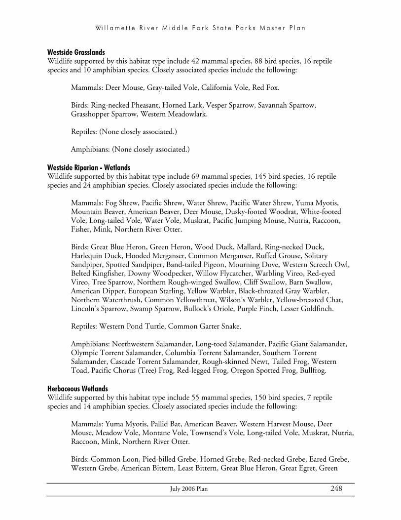
Wi l l a m e t t e R i v e r M i d d l e F o r k S t a t e P a r k s M a s t e r P l a n
July 2006 Plan 248
Westside Grasslands Wildlife supported by this habitat type include 42 mammal species, 88 bird species, 16 reptile species and 10 amphibian species. Closely associated species include the following:
Mammals: Deer Mouse, Gray-tailed Vole, California Vole, Red Fox.
Birds: Ring-necked Pheasant, Horned Lark, Vesper Sparrow, Savannah Sparrow, Grasshopper Sparrow, Western Meadowlark.
Reptiles: (None closely associated.)
Amphibians: (None closely associated.)
Westside Riparian - Wetlands Wildlife supported by this habitat type include 69 mammal species, 145 bird species, 16 reptile species and 24 amphibian species. Closely associated species include the following:
Mammals: Fog Shrew, Pacific Shrew, Water Shrew, Pacific Water Shrew, Yuma Myotis, Mountain Beaver, American Beaver, Deer Mouse, Dusky-footed Woodrat, White-footed Vole, Long-tailed Vole, Water Vole, Muskrat, Pacific Jumping Mouse, Nutria, Raccoon, Fisher, Mink, Northern River Otter.
Birds: Great Blue Heron, Green Heron, Wood Duck, Mallard, Ring-necked Duck, Harlequin Duck, Hooded Merganser, Common Merganser, Ruffed Grouse, Solitary Sandpiper, Spotted Sandpiper, Band-tailed Pigeon, Mourning Dove, Western Screech Owl, Belted Kingfisher, Downy Woodpecker, Willow Flycatcher, Warbling Vireo, Red-eyed Vireo, Tree Sparrow, Northern Rough-winged Swallow, Cliff Swallow, Barn Swallow, American Dipper, European Starling, Yellow Warbler, Black-throated Gray Warbler, Northern Waterthrush, Common Yellowthroat, Wilson’s Warbler, Yellow-breasted Chat, Lincoln’s Sparrow, Swamp Sparrow, Bullock’s Oriole, Purple Finch, Lesser Goldfinch.
Reptiles: Western Pond Turtle, Common Garter Snake.
Amphibians: Northwestern Salamander, Long-toed Salamander, Pacific Giant Salamander, Olympic Torrent Salamander, Columbia Torrent Salamander, Southern Torrent Salamander, Cascade Torrent Salamander, Rough-skinned Newt, Tailed Frog, Western Toad, Pacific Chorus (Tree) Frog, Red-legged Frog, Oregon Spotted Frog, Bullfrog.
Herbaceous Wetlands Wildlife supported by this habitat type include 55 mammal species, 150 bird species, 7 reptile species and 14 amphibian species. Closely associated species include the following:
Mammals: Yuma Myotis, Pallid Bat, American Beaver, Western Harvest Mouse, Deer Mouse, Meadow Vole, Montane Vole, Townsend’s Vole, Long-tailed Vole, Muskrat, Nutria, Raccoon, Mink, Northern River Otter.
Birds: Common Loon, Pied-billed Grebe, Horned Grebe, Red-necked Grebe, Eared Grebe, Western Grebe, American Bittern, Least Bittern, Great Blue Heron, Great Egret, Green

Wi l l a m e t t e R i v e r M i d d l e F o r k S t a t e P a r k s M a s t e r P l a n
July 2006 Plan 249
Heron, Canada Goose, Tundra Swan, American Wigeon, Mallard, Blue-winged Teal, Cinnamon Teal, Northern Shoveler, Northern Pintail, Green-winged Teal, Canvasback, Redhead, Lesser Scaup, Bufflehead, Ruddy Duck, Yellow Rail, Virginia Rail, Sora, American Coot, Sandhill Crane, Black-necked Stilt, American Avocet, Greater Yellowlegs, Lesser Yellowlegs, Solitary Sandpiper, Willet, Western Sandpiper, Least Sandpiper, Baird’s Sandpiper, Pectoral Sandpiper, Dunlin, Long-billed Dowitcher, Common Snipe, Wilson’s Phalarope, Franklin’s Gull, Caspian Tern, Forster’s Tern, Black Tern, Short-eared Owl, Tree Swallow, Northern Rough-winged Swallow, Barn Swallow, Marsh Wren, Common Yellowthroat, Lincoln’s Sparrow, Swamp Sparrow, Red-winged Blackbird, Yellow-headed Blackbird.
Reptiles: Snapping Turtle, Painted Turtle, Western Pond Turtle, Red-eared Slider Turtle, Common Garter Snake.
Amphibians: Tiger Salamander, Northwestern Salamander, Long-toed Salamander, Rough-skinned Newt, Great Basin Spadefoot, Western Toad, Woodhouse’s Toad, Pacific Chorus (Tree) Frog, Red-legged Frog, Oregon Spotted Frog, Columbia Spotted Frog, Northern Leopard Frog, Bullfrog.
Open Water Lakes, Rivers and Streams Wildlife supported by this habitat type include 23 mammal species, 115 bird species, 5 reptile species and 17 amphibian species. Closely associated species include the following:
Mammals: Western Small-footed Myotis, Yuma Myotis, Western Pipistrelle, Townsend’s Big-eared Bat, Pallid Bat, American Beaver, Muskrat, Nutria, Mink, Northern River Otter.
Birds: Horned Grebe, Red-necked Grebe, Eared Grebe, Western Grebe, American White Pelican, Double-crested Cormorant, Great Blue Heron, Great Egret, Snowy Egret, Black-crowned Night-heron, Canada Goose, Tundra Swan, Wood Duck, Gadwall, Eurasian Wigeon, Northern Shoveler, Northern Pintail, Canvasback, Redhead, Lesser Scaup, Harlequin Duck, Bufflehead, Common Goldeneye, Barrow’s Goldeneye, Hooded Merganser, Common Merganser, Osprey, Bald Eagle, American Coot, Black-bellied Plover, Semipalmated Plover, Black-necked Stilt, Greater Yellowlegs, Lesser Yellowlegs, Marblet Godwit, Semi-palmated Sandpiper, Western Sandpiper, Dunlin, Stilt Sandpiper, Wilson’s Phalarope, Ring-billed Gull, California Gull, Herring Gull, Glaucous Gull, Vaux’s Swift, Belted Kingfisher, Purple Martin, Tree Swallow, Northern Rough-winged Swallow, Bank Swallow, Cliff Swallow, Barn Swallow, American Dipper.
Reptiles: Snapping Turtle, Painted Turtle, Western Pond Turtle, Red-eared Slider Turtle.
Amphibians: Tiger Salamander, Northwestern Salamander, Long-toed Salamander, Rough-skinned Newt, Great Basin Spadefoot, Western Toad, Woodhouse’s Toad, Pacific Chorus (Tree) Frog, Red-legged Frog, Cascades Frog, Oregon Spotted Frog, Columbia Spotted Frog, Northern Leopard Frog, Bullfrog, Green Frog.
Agriculture, Pastures and Mixed Environs Wildlife supported by this habitat type include 96 mammal species, 210 bird species, 19 reptile species and 16 amphibian species. Closely associated species include the following:

Wi l l a m e t t e R i v e r M i d d l e F o r k S t a t e P a r k s M a s t e r P l a n
July 2006 Plan 250
Mammals: Virginia Opossum, Big Brown Bat, Brazilian Free-tailed Bat, Belding’s Ground Squirrel, Eastern Fox Squirrel, Northern Pocket Gopher, Camas Pocket Gopher, Botta’s Pocket Gopher, Deer Mouse, Bushy-tailed Woodrat, Montane Vole, Gray-tailed Vole, California Vole, House Mouse, Raccoon, Roosevelt Elk, Black-Tailed Deer.
Birds: Great Blue Heron, Cattle Egret, Greater White-fronted Goose, Snow Goose, Ross’ Goose, Canada Goose, Trumpeter Swan, Tundra Swan, American Wigeon, Blue-winged Teal, Cinnamon Teal, White-tailed Kite, Swainson’s Hawk, Red-tailed Hawk, Gray Partridge, Ring-necked Pheasant, Sandhill Crane, Black-bellied Plover, American Golden-Plover, Killdeer, Solitary Sandpiper, Willet, Whimbrel, Long-billed Curlew, Dunlin, Long-billed Dowitcher, Common Snipe, Rock Dove, Mourning Dove, Barn Owl, Short-eared Owl, Loggerhead Shrike, Northern Shrike, Black-billed Magpie, American Crow, Barn Swallow, American Pipit, Vesper Sparrow, Savannah Sparrow, Grasshopper Sparrow, Lazuli Bunting, Bobolink, Western Meadowlark, Brewer’s Blackbird, Brown-headed Cowbird, House Finch.
Reptiles: (None closely associated.)
Amphibians: (None closely associated.)
Urban and Mixed Environs Wildlife supported by this habitat type include 76 mammal species, 149 bird species, 21 reptile species and 18 amphibian species. Closely associated species include the following:
Mammals: Virginia Opossum, Brazilian Free-tailed Bat, Eastern Gray Squirrel, Eastern Fox Squirrel, Botta’s Pocket Gopher, Deer Mouse, Black Rat, Norway Rat, House Mouse, Raccoon.
Birds: Glaucous-winged Gull, Rock Dove, European Starling, House Finch, House Sparrow.
Reptiles: (None closely associated.)
Amphibians: (None closely associated.)

Wi l l a m e t t e R i v e r M i d d l e F o r k S t a t e P a r k s M a s t e r P l a n
July 2006 Plan 251
APPENDIX C HISTORIC GAGED RIVER FLOWS
MIDDLE FORK WILLAMETTE RIVER AT JASPER, OR USGS 14152000Lane County, Oregon Hydrologic Unit Code 17090001 Latitude 43°59'54", Longitude 122°54'17" NAD27 Drainage area 1,340.00 square miles Gage datum 513.45 feet above sea level NGVD29
Water Date Gage Stream Year Height flow (feet) (cfs) 1906 Jan. 16, 1906 7.10 21,100 1907 Feb. 04, 1907 15.00 82,600 1908 Dec. 25, 1907 15.90 90,500 1909 Jan. 15, 1909 12.60 59,900 1910 Nov. 23, 1909 17.40 94,000 1911 Nov. 28, 1910 13.00 54,000 1912 Jan. 12, 1912 14.40 65,600 1914 Jan. 22, 1914 8.00 19,000 1915 Jan. 14, 1915 7.40 15,400 1916 Feb. 07, 1916 12.40 49,200 1953 Jan. 18, 1953 16.60 73,4006
1954 Nov. 23, 1953 12.49 40,9006
1955 Dec. 30, 1954 8.19 17,9006
1956 Nov. 19, 1955 9.20 22,6006
1957 Dec. 11, 1956 10.37 28,5006
1958 Feb. 16, 1958 8.61 19,4006
1959 Jan. 27, 1959 8.07 16,3006
1960 Mar. 31, 1960 8.28 17,3006
1961 Feb. 10, 1961 11.91 37,0006
1962 Nov. 23, 1961 9.48 23,4006
1963 May 07, 1963 8.94 20,7006
1964 Jan. 20, 1964 9.33 20,3006
1965 Dec. 26, 1964 13.43 43,5006
1966 Jan. 08, 1966 8.85 18,2006
1967 Nov. 26, 1966 7.86 14,3006
1968 Jan. 16, 1968 6.59 9,9706
1969 Nov. 15, 1968 8.49 16,8006
1970 Feb. 08, 1970 8.60 17,2006
1971 Jan. 26, 1971 9.31 20,2006
1972 Dec. 17, 1971 9.41 20,6006
1973 Dec. 27, 1972 7.22 12,1006
Water Date Gage Stream Year Height flow (feet) (cfs) 1974 Dec. 12, 1973 9.14 19,4006
1975 Jan. 11, 1975 8.08 15,1006
1976 Dec. 09, 1975 9.01 18,8006
1977 Nov. 01, 1976 4.92 5,4206
1978 Dec. 24, 1977 9.43 20,1006
1979 Dec. 06, 1978 7.88 13,9006
1980 Jan. 20, 1980 8.69 17,0006
1981 Dec. 05, 1980 7.97 14,2006
1982 Dec. 26, 1981 9.20 19,1006
1983 Apr. 02, 1983 8.16 15,2006
1984 Jun. 07, 1984 9.31 19,6006
1985 Nov. 30, 1984 9.29 19,5006
1986 Feb. 26, 1986 9.70 21,5006
1987 Nov. 30, 1986 8.93 18,0006
1988 Jan. 14, 1988 8.41 15,9006
1989 Jan. 10, 1989 9.04 18,4006
1990 Apr. 29, 1990 8.76 17,3006
1991 May 18, 1991 7.79 13,7006
1992 Dec. 08, 1991 9.30 19,6006
1993 Jun. 04, 1993 8.25 15,3006
1994 Jan. 09, 1994 5.46 6,6906
1995 Feb. 03, 1995 8.74 17,2006
1996 Dec. 17, 1995 9.61 21,0006
1997 Dec. 25, 1996 10.07 23,3006
1998 Jan. 22, 1998 9.44 20,2006
1999 Dec. 31, 1998 9.68 21,4006
2000 Jan. 18, 2000 8.36 15,7006
2001 Dec. 04, 2000 5.16 5,9606
2002 Dec. 20, 2001 7.96 14,3006
2003 Mar. 27, 2003 7.05 11,3006
2004 Dec. 16, 2003 8.25 15,3006
2005 Dec. 13, 2004 7.09 11,4006

Wi l l a m e t t e R i v e r M i d d l e F o r k S t a t e P a r k s M a s t e r P l a n
July 2006 Plan 252
MIDDLE FORK WILLAMETTE RIVER NEAR DEXTER, OR USGS 14150000 Lane County, Oregon Hydrologic Unit Code 17090001 Latitude 43°56'45", Longitude 122°50'10" NAD27 Drainage area 1,001.00 square miles Gage datum 592.30 feet above sea level NGVD29
Water Date Gage Stream Year Height flow (feet) (cfs) 1947 Dec. 14, 1946 11.50 34,200 1948 Jan. 07, 1948 12.75 43,100 1949 Dec. 12, 1948 12.10 38,200 1950 Mar. 17, 1950 8.30 17,500 1951 Oct. 29, 1950 13.00 62,000 1952 Mar. 24, 1952 8.37 25,000 1953 Jan. 18, 1953 12.46 62,600 1954 Nov. 23, 1953 23,7006
1955 Jun. 09, 1955 6.12 8,8106
1956 Jan. 26, 1956 8.30 16,9006
1957 Dec. 20, 1956 7.83 15,0006
1958 Jan. 03, 1958 7.81 14,9006
1959 Jan. 30, 1959 7.27 12,9006
1960 Feb. 11, 1960 7.08 12,3006
1961 Feb. 26, 1961 7.47 13,6006
1962 Dec. 23, 1961 6.54 10,4006
1963 Dec. 13, 1962 7.39 13,4006
1964 Nov. 25, 1963 6.98 12,0006
1965 Dec. 26, 1964 11.06 29,5006
1966 Jan. 10, 1966 6.89 13,3006
1967 Nov. 27, 1966 7.03 12,1006
1968 Nov. 03, 1967 4.77 7,0906
1969 Nov. 20, 1968 6.97 12,1006
1970 Feb. 10, 1970 6.88 12,4006
1971 Jan. 26, 1971 7.69 14,8006
1972 Dec. 16, 1971 7.33 13,7006
1973 Dec. 27, 1972 5.33 8,5406
1974 Dec. 13, 1973 6.90 12,4006
1975 Jan. 26, 1975 5.47 8,8606
Water Date Gage Stream Year Height flow (feet) (cfs) 1976 Dec. 09, 1975 7.25 13,5006
1977 Oct. 29, 1976 4,4606
1978 Jan. 28, 1978 10.48 14,1006
1979 Dec. 05, 1978 8.59 9,1206
1980 Jan. 18, 1980 9.98 12,6006
1981 Dec. 06, 1980 8.86 9,7506
1982 Jan. 05, 1982 10.92 16,2006
1983 Dec. 21, 1982 9.33 11,6006
1984 Jun. 08, 1984 10.02 12,5006
1985 Nov. 16, 1984 9.73 11,7006
1986 Feb. 27, 1986 10.22 13,1006
1987 Dec. 01, 1986 9.85 11,9006
1988 Jan. 14, 1988 8.34 8,6906
1989 Nov. 22, 1988 8.51 9,0306
1990 Apr. 29, 1990 9.53 11,2006
1991 Nov. 14, 1990 8.33 8,6706
1992 Dec. 08, 1991 9.92 12,2006
1993 Jun. 03, 1993 9.52 11,1006
1994 Dec. 08, 1993 5.95 4,4206
1995 Feb. 05, 1995 10.02 12,5006
1996 Dec. 17, 1995 10.88 16,0006
1997 Dec. 16, 1996 10.86 16,5006
1998 Jan. 22, 1998 10.49 15,3006
1999 Dec. 07, 1998 10.30 14,7006
2000 Dec. 02, 1999 8.58 10,6006
2001 Dec. 04, 2000 6.34 5,8106
2002 Dec. 20, 2001 8.38 10,1006
2003 Jan. 07, 2003 6.99 7,0306
2004 Dec. 19, 2003 8.40 10,2006
2005 Dec. 13, 2004 7.20 7,4606
Peak Streamflow Qualification Codes:
6 - Discharge affected by regulation or diversion.

Wi l l a m e t t e R i v e r M i d d l e F o r k S t a t e P a r k s M a s t e r P l a n
July 2006 Plan 253
APPENDIX D PROJECTS FOR EXISTING FACILITY REHAB, UPGRADES, AND ACCESSORIESNote: The following list includes small projects, recommended by OPRD staff, for rehabilitating or upgrading existing park facilities. Most of these projects are not specifically mentioned in the chapters that describe park development concepts (chapters IX through XIV). Relatively small projects such as these need not be presented in the master plan in order to be implemented, provided that all necessary permits are obtained.
Cascara Campground:Upgrade restrooms with showers, flush toilets, solar power.
Relocate the campfire program area.
Upgrade electrical facilities.
Add on-site sewage disposal for host sites.
Consider minor realignment of the access road, adequate for large vehicles.
Upgrade tables and tent site pads.
Add gray water disposal.
Rehab the groundwater well.
Winberry:Redesign access to boating facilities to improve circulation.
Rehab main parking lot.
Replace vault toilet at west end.
Add restroom near the boat ramp.
Add a playground area.
Expand boat launch, design for low water use.
Replace transient floats.
Add on-site sewage disposal for host site.
Develop a potable water and irrigation system.
North Shore:Add boarding / transient floats.
Redesign parking to improve circulation.

Wi l l a m e t t e R i v e r M i d d l e F o r k S t a t e P a r k s M a s t e r P l a n
July 2006 Plan 254
Free Meadow:Add boat tie ups and boarding floats.
Replace portable toilet with vault toilet.
Lakeside 1:Improve boat launch, consider extending for low water use.
Replace portable toilet with vault toilet.
Lakeside 2:Replace portable toilet with vault toilet.
Lowell:Replace water system, add irrigation. Explore possible connections to City of Lowell water and sewer.
Rehab boat launch.
Replace moorage docks.
Add a swim dock.
Replace restroom building.
Plant large trees.
Fisherman’s Point:Replace portable toilet with vault toilet.
Dexter:Develop potable water system & irrigation.
Relocate host site, add on-site sewage disposal & upgrade RV pad.
Rehab boat ramp.
Plant large trees.
Elijah Bristow:Replace restroom building in day use area.
Add vault toilet near the interpretive site or orientation site.
Explore possible flood proofing of the maintenance buildings.
Redesign certain trails to reduce regular maintenance needs.
Add more interpretive signs.
Pengra Access:Pave upper parking area, add parking capacity.
Replace vault toilet.
Rehab boat ramp.
Jasper:Rehab parking lots

Wi l l a m e t t e R i v e r M i d d l e F o r k S t a t e P a r k s M a s t e r P l a n
July 2006 Plan 255
Rehab picnic grounds, replace shelters.
Replace restrooms.
Redevelop potable water & irrigation system, add storage.
Relocate host site, add on-site sewage disposal, upgrade RV pad.
Rehab restrooms. Add one more vault toilet.
Redesign & expand the shop and ranger office facility, add restroom. Consider 2nd road access, add fence, paved parking.

Wi l l a m e t t e R i v e r M i d d l e F o r k S t a t e P a r k s M a s t e r P l a n
July 2006 Plan 256
Free Meadow:Add boat tie ups and boarding floats.
Replace portable toilet with vault toilet.
Lakeside 1:Improve boat launch, consider extending for low water use.
Replace portable toilet with vault toilet.
Lakeside 2:Replace portable toilet with vault toilet.
Lowell:Replace water system, add irrigation. Explore possible connections to City of Lowell water and sewer.
Rehab boat launch.
Replace moorage docks.
Add a swim dock.
Replace restroom building.
Plant large trees.
Fisherman’s Point:Replace portable toilet with vault toilet.
Dexter:Develop potable water system & irrigation.
Relocate host site, add on-site sewage disposal & upgrade RV pad.
Rehab boat ramp.
Plant large trees.
Elijah Bristow:Replace restroom building in day use area.
Add vault toilet near the interpretive site or orientation site.
Explore possible flood proofing of the maintenance buildings.
Redesign certain trails to reduce regular maintenance needs.
Add more interpretive signs.
Pengra Access:Pave upper parking area, add parking capacity.
Replace vault toilet.
Rehab boat ramp.
Jasper:Rehab parking lots

Wi l l a m e t t e R i v e r M i d d l e F o r k S t a t e P a r k s M a s t e r P l a n
July 2006 Plan 257
Rehab picnic grounds, replace shelters.
Replace restrooms.
Redevelop potable water & irrigation system, add storage.
Relocate host site, add on-site sewage disposal, upgrade RV pad.
Rehab restrooms. Add one more vault toilet.
Redesign & expand the shop and ranger office facility, add restroom. Consider 2nd road access, add fence, paved parking.