Embed Size (px)
Citation preview

0
COUNTY OF GRANDE PRAIRIE NO. 1
Wildfire Mitigation Strategy
December 2015
FINAL VERSION

1
Table of Contents
1. Introduction 2
2. Background 3
3. Planning Area 4
4. Hazard and Risk Assessment 8
5. Mountain Pine Beetle Concerns 18
6. Sub Area Evaluations 25
7. Stakeholders 29
8. Values-at –Risk – General 34
9. Values-at-Risk – Specific 37
10. Wildfire Suppression Capability 44
11. Ongoing Consultation 45
12. Education and Communications 46
13. Legislation 48
14. Development 50
15. FireSmart Activities 50
16. Interagency Cooperation and Cross Training 81
17. Emergency Planning 82
18. Implementation Plan 82
19. Updates and Plan Maintenance 82

2
Wildfire Mitigation Strategy for the County of Grande Prairie
1. Introduction
The County of Grande Prairie No. 1 (the County) has been working closely with Alberta Agriculture and
Forestry (AF) for a number of years to minimize the fire hazard and risk on crown land within the
County’s administrative boundaries. Overall, this partnership has been very successful. However, with
the continued growth in population and development within the County, the need for a more formal,
approved approach to wildfire mitigation has not only increased dramatically but is essential to all that
work, live and play on or near forested land.
Although this strategy focuses on fuel reduction on crown and county lands, there is a component of
mitigation that applies to private land--especially land that is embedded or borders forested crown land.
There is also a significant component related to educating the public about FireSmart principles with a
focus on reducing hazard and risk factors and preventing wildfire. The approach of this strategy follows
closely the principles outlined in the “FireSmart Guidebook for Community Protection” published by the
Government of Alberta in 2013 and the Wildfire Mitigation Strategy format shown on page 77. These
same principles apply to private land --especially those related to “FireSmarting” homes or businesses.
This strategy recommends a close partnership with all the main stakeholders including AF, the County
and where appropriate private land owners and businesses and to apply FireSmart tactics to reduce the
risk of wildfire or if there is a wildfire to reduce the risk of loss of life and damage to infrastructure.
The County has received a number of grants from AF and the Forest Resource Improvement Association
of Alberta (FRIAA) for FireSmart fuel management projects. These projects have mostly focused on the
priority areas south of the City of Grande Prairie in the general area known as the Wapiti Sand Dunes. In
the spring of 2014, the County received a grant from FRIAA to specifically develop a “Wildfire Mitigation
Strategy” for the entire County. This document outlines this strategy including 74 key recommendations
for future FireSmart projects such as fuel reduction, communications and public education. These
recommendations are placed at the end of the relevant paragraph or section.
This document was developed with input and advice from Forrest Barrett, Wildfire Operations Officer,
and Mike Kingsbury, Wildfire Prevention Officer, both with AF in Grande Prairie, and with input and
direct contribution from various departments in the County including Planning and Regional Fire
Services.
All recommendations and projects that require funding must be reviewed and approved by the County
Council before proceeding. All recommendations with AF responsibility are subject to provincial budgets
and resources. Any future FireSmart projects involving private or leased crown land would be subject to
funding and approval of the land or lease owner.

3
2. Background
Although the County is mostly prairie and farm land, it is surrounded by boreal forest on the north, west
and south. This same forest also forms part of the landscape within the borders of the County. The
current forest cover in the County has been shaped by a number of factors including settlement,
homesteading, industrial development and wildfire. During the late 1800’s and the early part of the
1900’s, large forest fires were common especially in the areas south of Grande Prairie and on both sides
of the Wapiti River. Anecdotal evidence and local knowledge indicate fires of various sizes occurred in
the Wapiti Sand Dunes in the 1940’s and 1950’s. Grass and brush fires would have been common
throughout the County especially during periods of severe drought. Since much of the sand dunes are
currently covered by an even aged stand of pine that is approximately 90 years old, it can be presumed
that much of this area burned in the 1920’s. Aspen stands throughout the County vary in age. Some of
the younger aspen stands in the County originated from clearing for settlement and grazing but
subsequently returned to forests; others originated when First Nations stopped burning to promote
grass. Generally, the aspen stands in the County are from 50 to 60 years of age to 100 plus.1
With the increasing role of fire prevention and suppression by the Government of Alberta and local
municipalities, there has not been a major forest fire in the County since the mid 1950’s. As the
coniferous forest matures and with the ongoing Mountain Pine Beetle (MPB) infestation, forest fuel
loading and the risk of wildfires have increased considerably in the last few years. At the same time,
access to and recreational use of crown land in the County have also increased. This is causing an
increased number of recreational fires (directly from ATVs and unauthorized camp fires).
Industrial development, mainly by the energy sector, is a factor on crown land in the County--especially
in the western and northern portions. Within these areas, the predominant forest cover is deciduous
(mainly aspen/poplar, D-1 and D-2 Canadian Forest Fire Behaviour Prediction System (FBP) fuel types)
and the fire risk is much lower as compared to coniferous forests. The very south west corner of the
County is in the Forest Management Agreement Area (FMA) of Weyerhaeuser. Some harvest of mature
stands was completed by Weyerhaeuser in this area in 2012. This greatly reduced the volume and area
of older forest thus reducing the fire risk. The northern border of the County is against the base of the
Saddle Hills which is also part of Weyerhaeuser’s FMA. Timber harvest in this area has also reduced the
area of older forest. Wildfire risk to residents and infrastructure in most of the County is low due a lack
of coniferous forest being present. South of the County and south of the Wapiti River adjacent to the
highway 40 corridor is an area of immature and mature coniferous forest that is of limited risk to the
County developments but should still be addressed in this strategy.
In summary, the highest risk area in the County for wildfire is in the coniferous forest that is common to
the Wapiti Sand Dunes. This area stretches from the Smoky River in the east to Pipestone Creek in the
west. Although fuel modification in the Wapiti Sand Dunes is therefore the highest priority for this
strategy, it will include recommendations around public education, identification of values-at-risk
1 Email communication from Geoff Atkinson, Area Forester, Alberta Agriculture and Forestry, January 16, 2015
4
throughout the County, cooperation with other municipalities and communities, and other mitigation
initiatives.
3. Planning Area
The County is located 460 kilometres northwest of Edmonton in the Peace Country Area of Alberta
(Figure 1). It is bounded on the south by the Wapiti River, on the east by the Smoky River, on the north
by the Saddle Hills and on the west by the BC border. Total area is 5,863 square kilometres and the
population in 2012 including the five hamlets and one village was 21,157. An additional 61,000+ people
live within the boundaries of the County in the City of Grande Prairie and the towns of Sexsmith,
Wembley and Beaverlodge. Adjacent municipalities include the MD of Greenview to the south and east
and the Counties of Saddle Hills and Birch Hills to the north. The province of British Columbia is to the
west.
As part of the Great Plains Region of Canada, 40 percent of the County is prime farmland. The remainder
and mostly along the south, west and north borders is marginal farmland, grazing leases and forest.
Approximately 77 percent of the total land base is privately held; the rest or 23 percent is public crown
land (Figure 2). The County owns a small percentage of the total land base including municipal reserves,
parks and gravel leases.
Although this strategy is for the entire County, the focus is on the public crown land. However, in some
areas effective FireSmart projects need to include work on private land. Any recommendations involving
private land would have to be done in cooperation with the land owners and would be subject to their
approval and appropriate funding.
3.1. Biophysical Description
The terrain in the County is generally flat to small rolling hills. The lowest elevation is 440 metres in the
northeast corner along the Smoky River while the highest is along the BC border in the southwest corner
at just over 1000 metres. Generally, the elevation on the County ranges between 600 and 800 metres
with deep valleys along the Wapiti and Smoky Rivers. These valleys typically range from 100 to 150
metres deep. Saskatoon Mountain near Beaverlodge has a maximum height of 940 metres and is
generally 150 metres higher than the surrounding farm land. The north boundary of the County is at the
base of the Saddle Hills which has a maximum elevation of 967 metres.
Much of the forest area on crown land in the County is dominated by aspen with a varying degree of
spruce both in the overstory and understory. Pine stands are scattered throughout but overall are a
minor component in these aspen areas.

5
Although the area also contains numerous treed muskegs, these areas often dry out considerably in the
spring and may burn under the right conditions (depending upon spring runoff and spring weather). This
area also contains a mix of aspen and poplar with a component of grass that can be a high fire hazard in
the spring before green-up. This is especially evident along south facing slopes.
Even with the high wildfire risk, the Wapiti Sand Dunes area has been a desired location for
development due in part to the terrain features and the mature forest cover. This development includes
both commercial facilities and private residents on private land embedded or adjacent to crown land.
There are also a number of developments and facilities (mostly related to recreational and community
groups) on leased public land. This associated infrastructure and the proximity to the City of Grande
Prairie makes the Wapiti Sand Dunes the highest priority for fuel management projects in the County.

6
Figure 1. Location of the County of Grande Prairie.

7
Figure 2. County of Grande Prairie showing land ownership.

8
4. Hazard and Risk Assessment
The hazard and risk assessment is an important component in analysing the fuels which can support
combustion (hazard) and the likelihood of a wildfire starting (risk). This process involves an analysis of
historical fire data, fire behaviour potential, forest fuels and potential impacts to values-at-risk.
4.1. Wildfire Occurrence
The majority of the County of Grande Prairie is located outside of the Forest Protection Area and
contains large parcels of private and municipal land ownership. This has resulted in difficulty tracking
the majority of current and historical wildfire occurrences due to differences in record keeping between
municipal/county fire departments and Agriculture and Forestry’s Wildfire Management Branch.
4.2. Wildfire History – Agriculture and Forestry Records
Based on information obtained from the Agriculture and Forestry historical fires database, the County of
Grande Prairie has had few large wildfires within the planning area (Figure 3). There have been several
large wildfires between 1931 and 1959 adjacent to the county and numerous small wildfires both inside
and outside of the County of Grande Prairie (Figure 4). Analysis of the historic wildfire data adjacent to
the county and the large areas of grass fuels within the county boundaries indicate that given
appropriate weather and fuels conditions (indices), the threat of large-scale fires exists. This threat is
significantly increased when mountain pine beetle attacked lodgepole pine is included.
The following is a summary based on Agriculture and Forestry records of wildfires within the County of
Grande Prairie over the last 25 years:
Table 1. Wildfire history for the County of Grande Prairie based on AF historical fire records.
Period
Number of
Wildfire FPA
Median FPA Fire Size (Ha)
Average FPA Fire Size (Ha)
Number of Wildfires Non-FPA
Median Non-FPA Fire Size
(Ha)
Average Non-FPA Fire Size (Ha)
1990-1994 1
0.03 1.01
0
0.50 2.51
1995-1999 14 3
2000-2004 26 9
2005-2009 34 26
2010-2014 26 3
Of the 101 wildfires in the FPA portion of the county over the 25 year period, 81 were human caused
and 20 were due to lightning.

9
Figure 3. Historic large wildfire perimeters (greater than 200 hectares) in and adjacent to the County of
Grande Prairie.
"
"
"
"
$
$
"
"""
"
"
"
"
""
""
""
"
"
"
"
"
"
""
"
"
" ""
"
"
""
"
!
!
!
!!
!
!
!
!
!
!
!
!
!
!
!
!
!
!
"/
"/
"/
"/ _̂
!.
!. Niobe
Manir
Gundy
Wapiti
BelloyCodesa
Goodwin
Lymburn
Webster
Halcourt
Hayfield
Albright
Brainard
Valhalla
Braeburn
Hazelmere
Leighmore
Bad Heart
Homestead
Northmark
Rio Grande
Bridgeview
Silverwood
Prestville
Puskwaskau
Horse Lake
Glen Leslie
Poplar Hill
Aspen Grove
Hinton TrailMount Valley
Buffalo Lake
Happy Valley
Lake Saskatoon
Pipestone Creek
Clarkson Valley
Nose Creek Settlement
Wanyandie Flats East Settlement
Hythe
Rycroft
Wembley
Sexsmith
Beaverlodge
Spirit River
Grande Prairie
Peoria
DeBolt
Woking
Wanham
Huallen
Demmitt
Elmworth
Dimsdale
Goodfare
Bezanson
La Glace
Wedgewood
Grovedale
Clairmont
Ridgevalley
Teepee Creek
Landry Heights
Valhalla Centre
¹
0 20 4010 Kilometres
Historical Wildfire Perimeter
1931 - 1945
1946 - 1959
1960 - 1972
1973 - 1986
1987 - 2000
2001 - 2014
County of Grande Prairie
Forest Protection AreaNote: Information as depicted is subject to change; therefore the Government of Alberta assumes no
responsibility for discrepancy at the time of use.
Base Map Data Provided by Spatial Data Warehouse Ltd.
©2015 Government of Alberta

10
Figure 4. Historic fire locations based on AF records from 1961 to 2014. Note the extensive fire
occurrence south of the City of Grande Prairie.
"
"
"
"
$
$
"
"""
"
"
"
"
""
""
""
"
"
"
"
"
"
""
"
"
" ""
"
"
""
"
!
!
!
!!
!
!
!
!
!
!
!
!
!
!
!
!
!
!
"/
"/
"/
"/ _̂
!.
!.
BB
BB
BB
BB
BB
BBBB
BB
BB
BB
BB
BB
BB
BB
BB
BB
BB
BB
BB
BB
BB
BBBB
BB
BB
BB
BB
BB
BB
BB
BB
BB
BB
BB
BB
BBBB
BB
BB
BB
BB
BB
BB
BB
BB
BB
BB
BB
BB
BB
BB
BBBB
BB
BB
BB
BBBB
BB
BB
BB
BB
BB
BB
BB
BB
BB
BB
BB
BB
BBBB
BBBB
BB
BB
BB
BBBB
BB
BB
BBBB
BB
BB
BB
BB
BB
BB
BB
BB
BB
BB
BB
BB
BB
BBBB
BB
BB
BBBB
BB
BB
BB
BB
BB
BB
BB
BB
BB
BB
BB
BB
BB
BB
BB
BB
BB
BB
BB
BB
BB
BB
BB
BB
BB
BB
BB
BB
BB
BB
BB
BB
BB
BB
BB
BB
BB
BB
BB
BB
BB
BB
BB
BB
BB
BB
BB
BB
BB
BB
BB
BB
BB
BB
BB
BBBB
BB
BB
BBBB
BB
BB
BB
BB
BB
BB
BB
BB
BBBB
BB
BB
BB
BB
BB
BB
BB
BB
BB
BBBB
BB
BB
BB
BB
BB
BB
BBBB
BB
BB
BB
BBBB
BB
BB
BB
BB
BB
BBBB
BB
BB
BB
BB
BB
BB
BB
BBBB
BB
BB
BB
BB
BB
BBBB
BB
BB
BBBB
BB
BB
BB
BB
BB
BB
BB
BB
BB
BB
BB
BB
BB
BB
BB
BB
BB
BBBBBB
BB
BB
BBBBBB
BB
BB
BB
BB
BB
BB
BB
BB
BBBB
BB
BB
BB
BB
BB
BB
BB
BB
BB
BB
BB
BB
BB
BB
BB
BBBB
BB
BB
BB
BB
BB
BBBB
BB
BB
BB
BB
BB
BB
BB
BB
BB
BB
BB
BB
BB
BB
BB
BB
BB
BB
BB
BBBB
BB
BB
BB
BB
BB
BB
BB
BB
BB
BB BB
BB
BB
BB
BB
BB
BB
BBBB
BB
BB
BB
BB
BBBB
BB
BB
BB
BBBB
BB
BB
BB
BB
BB
BB
BB
BB
BB
BB
BB
BB
BB
BBBB
BB
BB
BBBBBB
BB
BB
BB
BB
BB
BB
BB
BB
BB
BBBB
BB
BBBBBB
BB
BB
BB
BB
BB
BB
BB
BB
BB
BB
BB
BB
BBBB
BB
BB
BB
BB
BB
BB
BB
BB
BB
BB
BB
BB
BB
BB
BB
BB
BB
BB
BB
BB
BB
BBBB
BB
BB
BB
BB
BB
BB
BB
BB
BB
BB
BB
BB
BB
BB
BB
BB
BB
BB
BB
BB
BB
BB
BB
BBBB
BB
BB
BB
BB
BB
BB
BB
BB
BB
BB BB
BB
BB
BBBBBB
BB
BB
BB
BB
BB
BB
BB
BB
BB
BB
BB
BB
BB
BBBB
BB
BB
BB
BB
BB
BB
BB
BB
BB
BB
BB BB
BB
BB
BB
BB
BB
BB
BB
BB
BB
BB
BBBBBB
BB
BBBB
BB
BB
BB
BB
BB
BB
BB
BB
BB
BB
BB
BB
BB
BB BB
BB
BB
BBBB
BB
BB
BB
BB
BB
BB
BB
BB
BB
BB
BB
BB
BB
BB
BB
BB
BB
BB
BB
BB
BB
BB
BB
BB
BB
BB
BB
BB
BBBB
BB
BB
BB
BBBB
BB
BB
BB
BB
BB
BB
BB
BB
BB
BB
BB
BB
BB
BB
BB
BB
BB
BB
BB
BB
BB
BB
BB
BB
BB
BB
BB
BB
BB
BB
BB
BB
BB
BB
BB
BB
BB
BB
BB
BB
BB
BB
BB
BB
BB
BB
BB
BB
BB
BB
BB
BB
BB
BB
BB
BB
BB
BB
BB
BB
BB
BB
BB
BB
BB
BB
BBBBBB
BBBB
BB
BB
BB
BB
BBBB
BB
BBBB
BB
BB
BB
BB
BB
BB
BB
BB
BBBB
BB
BB
BBBB
BBBB
BBBB
BB
BB
BB
BB
BB
BB
BB
BBBB
BB
BB
BB
BB
BB
BB
BBBB
BB
BB
BBBB
BB
BB
BB
BB
BB
BB
BB
BB
BB
BB
BB
BB
BB
BB
BB
BB
BB
BB
BB
BB
BB
BB
BB
BB
BB
BB
BB
BB
BB
BB
BBBB
BBBB
BB
BBBB
BB
BB
BB
BB
BB
BB
BB
BB
BB
BB
BB
BB
BB
BB
BB
BB
BB
BB
BB
BB
BB
BB
BB
BB
BB
BB
BB
BB
BB
BB
BB
BB
BB
BB
BB
BB
BB
BB
BB
BB
BBBB
BB
BB
BB
BB
BB
BB
BB
BB
BB
BB
BB
BB BB
BB
BB
BB
BB
BB
BB
BB
BBBB
BB
BB
BB
BB
BB
BB
BB
BB
BB
BB
BB
BB
BB
BB
BB
BB
BB
BB
BB
BB
BB
BB
BB
BB BB
BB
BB
BB
BB
BB
BB
BB
BB
BB
BB
BB
BB
BB
BB
BB
BB
BB
BB
BB
BB
BB
BB
BB
BB
BB
BB
BB
BB
BB
BB
BB
BB
BB
BB
BB
BB
BB
BB
BB
BB
BB
BB
BB BB
BB
BB
BB
BB
BB
BB
BB
BB
BB
BB
BB
BBBB
BB
BB
BB
BB
BBBBBBBBBBBB
BBBB
BB
BB
BB
BB
BB
BB
BB
BB
BB
BB
BB
BB
BB
BB
BB
BB
BB
BB
BB
BB
BB
BB
BB
BBBB
BB
BB
BB
BB
BB
BB
BB
BB
BB
BB
BB
BB
BB
BB
BB
BB
BB
BB
BBBB
BB
BB
BB
BB
BB
BB
BB
BB
BB
BB
BB
BB
BB
BB
BB
BB
BB
BB
BB
BB
BB
BBBB
BB
BB
BB
BB
BB
BB
BB
BB
BB
BB
BB
BB
BB
BB
BB
BB
BB
BB
BB
BB
BB
BB
BB
BB
BB
BB
BB
BB
BB
BB
BB
BB
BB
BB
BB
BB
BB
BB
BB
BB
BBBB
BB
BB
BB
BB
BBBB
BB
BB
BB
BB
BB
BB
BBBB
BB
BB
BB
BB
BB
BB
BB BB
BB
BB
BBBB
BB
BB
BB
BB
BB
BB
BB
BB
BB
BB
BB
BB
BB
BB BB
BB
BB
BB
BB
BB
BB
BB
BB
BB
BB
BB
BBBB
BB
BB
BB
BB BB
BB
BB
BB
BB
BB
BB
BBBB
BB
BB
BB
BB
BB
BB
BBBB
BB
BB
BB
BB
BBBB
BB
BB
BB
BB
BB
BB
BB
BB
BB
BBBB
BBBBBBBBBB
BB
BB
BB
BB
BB
BB
BB
BB
BB
BB
BB
BB
BB
BB
BB
BB
BB
BB
BB
BB
BBBB
BB
BB
BB
BB
BB
BB
BB
BB
BB
BB
BB
BB
BB
BB
BB
BB
BB
BBBB
BB
BB
BB
BBBB
BB
BB
BB BB
BB
BBBB
BB
BB
BB
BB
BB
BBBBBB
BBBBBBBBBBBB
BB
BB
BB
BB
BB
BB
BB
BB
BB
BB
BB
BB
BB
BB
BB
BB
BB
BB
BB
BB
BB
BB
BB
BB
BB
BB
BB
BB
BB
BB
BB
BB
BB
BB
BB
BB
BB
BB
BB
BB
BB
BB
BB
BB
BB
BB
BB
BB
BBBB
BB
BB
BB
BB
BB
BB
BB
BBBB
BB
BB
BB
BB
BBBB
BB
BB
BBBB
BB
BB
BB
BB
BB
BB
BB
BB
BB
BB
BB
BBBB
BB
BB
BB
BB
BB
BB
BB
BB
BB
BBBB
BB
BB
BB
BB
BBBB
BB
BB
BB
BB
BB
BB
BB
BB
BB
BB
BB
BB
BB
BB
BB
BB
BB
BB
BB
BBBB
BB
BB
BB
BB
BB
BB
BB
BB
BBBB
BB
BB
BB
BB
BB
BB
BB
BB
BB
BB
BB
BB
BB
BBBBBB
BB
BB
BB
BB
BB
BB
BB
BB
BB
BB
BB
BB
BB
BB
BB
BB
BB
BB
BB
BB
BB
BB
BB
BBBB
BB
BB
BB
BB
BB
BB
BB
BB
BB
BB
BB
BB
BB
BB
BB
BB
BB
BB
BB
BB
BB
BB
BB
BB
BB
BB
BB
BB
BB
BB
BB
BB
BB
BB
BBBB
BB
BB
BB
BB
BB
BB
BB
BB
BB
BB
BB
BB
BB
BB
BB
BB
BB
BB
BB
BB
BB
BB
BB
BB
BB
BB
BB
BB BB
BB
BB
BB
BB
BB
BB
BB
BB
BB
BB
BB
BB
BB
BB BB
BB
BB
BB
BB
BB
BB
BB
BB
BB
BB
BB
BB
BB
BB
BB
BB
BB
BB
BB
BB
BB
BB
BB
BB
BB
BB
BB
BBBB
BB
BB
BB
BB
BB
BB
BB
BB
BB
BB
BBBB
BB
BB
BB
BBBBBB
BB
BBBB
BB
BB
BB
BB
BB
BB
BB
BB
BB
BB
BB
BB
BB
BB
BB
BB
BB
BB
BBBBBB
BB
BB
BB
BB
BB
BBBBBB
BB
BB
BB
BB
BB
BB
BB
BB
BB
BB
BB
BB
BB
BB
BB
BB
BB
BB
BB
BB
BB
BB
BB
BB
BB
BB
BB
BB
BB
BB BB
BB
BB
BB
BB
BB
BB
BB
BB
BB
BBBB
BB
BB
BB
BB
BB
BB
BB
BB
BB
BB
BB
BB
BB
BB
BBBB
BB
BB
BB
BB
BB
BB
BB
BB
BB
BB
BB
BB
BB
BB
BB
BB
BB
BB
BB
BB
BB
BB
BB
BB
BB
BB
BB
BB
BB
BB
BB
BB
BB
BB
BB
BB
BB
BB
BB
BB
BB
BB
BBBB
BB
BB
BB
BB
BB
BB
BB
BB
BB
BB
BBBBBB
BB
BB
BBBB
BB
BB
BB
BB
BB
BB
BB
BB
BB
BB
BB
BB
BB
BB
BB
BB
BB
BB
BB
BB
BB
BB
BB
BB
BB BB
BB
BB
BB
BB
BB BB
BB
BB
BB
BB
BB
BB
BB
BB
BB
BB
BB
BB
BB
BB
BB
BB
BB
BB
BB
BB
BB
BB
BB
BB
BB
BB
BB
BB
BB
BB
BB
BB
BBBB
BB
BB
BB
BB
BB
BB
BB
BB
BB
BB
BB
BB
BB
BB
BB
BB
BB
BB
BB
BB
BB
BB
BB
BB
BBBB
BB
BB
BBBB
BB
BB
BB
BB
BB
BB
BB
BB
BB
BB
BB
BB
BB
BB
BB
BB
BB
BB
BB
BB
BB
BB
BB
BB
BB
BB
BB
BB
BB
BB
BB
BB
BB
BBBB
BB
BB
BB
BB
BB
BB
BBBB
BB
BB
BB
BB
BB
BB
BB
BB
BB
BB
BB
BB
BBBB
BB
BBBB
BBBB
BB
BB
BB
BB
BB
BB
BB
BB
BB
BB
BB
BB
BB
BB
BB
BB
BB
BB
BB
BB
BB
BB
BB
BB
BB
BB
BB
BB BB
BB
BB
BB
BB
BB
BB
BB
BB
BB
BB
BB
BB
BB
BB
BB
BBBB
BB
BB
BB
BB
BB
BB
BB
BB
BB
BB
BB
BB
BB
BB
BB
BB
BB
BB
BB
BB
BB
BB
BBBB
BB
BB
BB
BB
BB
BB
BB
BB
BBBB
BB
BB
BB
BB
BB
BB
BB
BB
BB
BB
BB
BB
BA
BA
BA
BA
BA
BABA
BA
BA
BA
BA
BA
BA
BA
BA
BA
BA
BA
BA
BA
BABA
BA
BA
BA
BA
BA BA
BABA
BA
BA
BA
BA
BA
BA
BA
BA
BA
BABA
BA
BA
BA
BA
BABA
BA
BA
BA
BA
BA
BA
BA
BA
BA
BA
BA
BA
BA
BA
BA
BA
BA
BA
BA
BA
BA
BA
BA
BABA
BA
BA
BA
BA
BA
BA
BA
BA
BABABABA BABA
BA
BA
BABA
BA
BA
BA
BA
BA
BA
BA
BA
BABA
BABA BA
BA
BA
BA
BA
BA
BA
BA
BA
BABA
BA
BA
BA
BA
BA
BA
BABA
BABA
BA
BA
BA
BA
BABA BA
BA
BA
BABA
BA
BA
BA
BA
BA
BABA
BA
BA
BA
BA
BA
BA
BA
BA
BA
BA
BA
BABA
BA
BA
BABA
BA
BA
BA
BA
BA
BA
BA
BA
BA BA
BA
BA
BA
BA
BA
BA
BA
BABA
BA
BA
BA
BA
BA
BA
BA
BA
BA
BA
BA
BA
BA
BA
BA
BA
BA
BA
BA
BA
BA
BA
BA
BA
BA
BA
BA
BA
BA
BA
BA
BA
BA
BA
BA
BABA
BA
BA
BA
BA
BA
BABA
BA
BA
BA
BA
BABA
BA
BA
BA
BA
BA
BA
BA
BA
BA
BA
BA
BA
BA
BA
BA
BA
BA
BA
BA
BA
BA
BA
BA
BA
BA
BA
BA
BA
BA
BA
BA BA
BA
BA
BA
BA
BA
BA
BA
BA
BA
BABA
BA
BA
BA
BA
BA
BA BABA BA
BA
BA
BA
BA
BA
BABA
BA
BABA
BA
BA
BA
BA
BA
BA
BA
BABA
BABA
BA
BA
BA
BA
BA
BA
BA
BABA
BA
BA
BA
BA
BA
BA
BA
BA
BA
BA
BA
BA
BA
BABA
BA
BA
BA
BA
BABA
BA
BA
BA
BA
BA
BA
BA
BA
BA
BA
BA
BA
BA
BA
BA
BA
BA
BA
BA
BA
BA
BA
BA
BA
BA
BA
BA
BA
BA
BA
BA
BA
BA
BA
BA
BA BA
BA
BA
BA
BA
BABA
BA
BA
BA
BA
BA
BA
BA
BA
BA
BA
BA
BA
BA
BA
BABA
BA
BA
BA
BA
BA
BABA
BABA
BA
BA
BA
BA
BA
BA
BABABABA
BA
BA
BA
BA
BABA
BABABA
BA
BA
BA
BA
BA
BA
BA
BABA
BA
BA
BA
BA
BA BA
BA
BA
BA
BA
BA
BA
BA
BA
BABA
BA
BABABABABABABA BA
BA
BABABA
BA
BA
BA
BA
BA
BA
BA
BA
BA
BA
BA
BA
BA
BA
BA
BABA
BA
BA
BA
BA
BA
BA
BABA
BA
BA
BA
BA
BABA
BA
BA
BA
BA
BABA
BA
BA
BA
BA
BA
BA
BA
BA
BABABA
BA
BA
BA
BA
BA
BABA
BA
BA
BA
BA
BA
BA
BA
BA
BABA
BABA
BA
BA
BA
BABA
BABA
BABA
BA
BA
BA
BA
BA
BA
BA
BA
BA
BABA
BA
BA
BA
BA
BA
BA
BA
BA
BA
BABA
BA
BA
BA
BA
BA
BA
BA
BABA
BA
BA
BA
BA
BA
BA
BABA
BABA
BA
BA
BA
BA
BABA
BA
BA
BA
BA
BA
BABA
BA
BA
BABABA
BA
BA
BABA
BABABABABA
BA
BA
BA
BABABABA
BA
BA
BA
BA
BA
BA
BA
BA
BABABA
BA
BA
BABA
BA
BA
BA
BA
BA
BA
BA
BABA
BA
BA
BA
BA
BA
BA
BA
BA
BA
BA
BA
BA
BA
BA
BA
BA
BA
BA
BA
BA
BA
BA
BA
BA
BA
BA
BA
BA
BA
BA
BA
BA
BA
BA
BA
BABA
BA
BA
BA
BA
BABA
BA
BA
BA
BA
BA
BA
BABA
BA
BA
BA
BA
BA
BA
BA
BA
BA
BA
BA
BA
BA BA
BA
BA
BA
BA
BABA
BA
BA
BABA
BA
BA
BA
BA
BA
BA
BA
BA
BA
BA
BA
BA
BA
BA
BA
BA
BA
BA
BA
BA
BA
BA
BA
BA
BA
BA
BABA
BA
BA
BABA
BA
BA
BA
BA
BA
BA
BA
BA
BA
BABA
BA
BA
BA
BA
BA
BA
BA
BABA
BA
BABA
BA
BA
BA
BABA
BA
BA
BA
BA
BA
BA
BA
BA
BA
BA
BA
BA
BA
BA
BA
BA
BABA
BA
BA
BABA
BA
BA
BA
BA
BA
BA
BA
BA
BA
BA
BA
BA
BA
BABA
BA
BA
BA
BA
BA
BA
BA
BABA
BA
BA
BA
BA
BABA
BABA
BA
BA
BA
BA
BA
BA
BA
BA
BA
BABA
BABA
BA
BABA
BA
BA
BA
BA
BA
BABA
BA
BA
BA
BABA
BA
BA
BA
BA
BA
BA
BA BA
BA
BA
BA
BA
BA
BA
BA
BA
BA BA
BA
BA
BA
BA
BA
BA
BA
BA
BA
BA
BA
BA
BA
BA
BABA
BA
BA
BA
BA
BA
BA
BA
BA
BABA
BA
BA
BABA BA
BA
BA
BA
BA
BA
BA
BA
BA
BA
BA
BA
BA
BA
BABA
BA
BA
BA
BA
BA
BA
BA
BA
BA
BA
BA
BA
BA
BA
BA
BA
BA
BA
BA
BA
BA
BA
BA
BABA
BA
BA
BA
BA
BA
BA
BA
BABA
BA
BA
BA
BA
BA
BA
BA
BA
BA
BA
BA
BABABA
BABABA
BA
BABA
BABA
BA
BA
BA
BA
BA
BA
BA
BA
BA
BA
BA
BA
BA
BA
BA
BA
BA
BA
BA
BA
BA
BA
BA
BA
BA
BABA
BABA
BA
BA
BA
BA
BA
BA
BA
BA
BA
BA
BA
BA
BA
BA
BA
BA
BA
BA
BA
BA
BA
BA
BA
BABA
BA
BA
BA
BA
BA
BA
BA
BA
BA BA
BA
BA
BA
BA
BA
BABA
BA
BA
BABA
BA
BA
BA
BA
BA
BA BA
BA
BA
BA
BA
BA
BA
BA
BA
BA
BA
BA
BABA
BA
BA
BA
BA
BA
BA
BA
BA
BA
BA
BA
BA
BA
BA
BA
BA
BA
BA
BA
BA
BA
BA
BABA
BA
BA
BA
BA
BA
BA
BA
BA
BA
BA
BA
BA
BA
BA
BA
BA
BA
BA
BA
BA
BA
BABABA
BA
BABA
BABA
BA
BA
BA
BA
BABA
BA
BA
BABABA
BABA
BA
BA
BA
BA
BA
BA
BA
BA
BA
BA
BA
BA
BA
BA
BA
BA
BA
BA
BA
BA
BA
BA
BA
BA
BA
BA
BA
BA
BA
BA
BABA
BA
BA
BABA
BA
BA
BA
BA
BA
BA
BA
BA
BA
BA
BA
BA
BA
BA
BA
BA
BA
BA
BA
BA
BA
BA
BA
BA
BA
BA
BA
BA
BA
BA
BA
BA
BA BA
BA
BA
BA
BA
BA
BA
BA
BA
BA
BA
BA BA
BA
BA
BA
BA
BA
BA
BA
BA
BA
BA
BA
BA
BA
BA
BA
BA
BA
BA
BA
BA
BA
BA
BA
BA
BA
BA
BA
BA
BA
BA
BA
BA
BABA
BA
BA
BA
BA
BA
Niobe
Manir
Gundy
Wapiti
BelloyCodesa
Goodwin
Lymburn
Webster
Halcourt
Hayfield
Albright
Brainard
Valhalla
Braeburn
Hazelmere
Leighmore
Bad Heart
Homestead
Northmark
Rio Grande
Bridgeview
Silverwood
Prestville
Puskwaskau
Horse Lake
Glen Leslie
Poplar Hill
Aspen Grove
Hinton TrailMount Valley
Buffalo Lake
Happy Valley
Lake Saskatoon
Pipestone Creek
Clarkson Valley
Nose Creek Settlement
Wanyandie Flats East Settlement
Hythe
Rycroft
Wembley
Sexsmith
Beaverlodge
Spirit River
Grande Prairie
Peoria
DeBolt
Woking
Wanham
Huallen
Demmitt
Elmworth
Dimsdale
Goodfare
Bezanson
La Glace
Wedgewood
Grovedale
Clairmont
Ridgevalley
Teepee Creek
Landry Heights
Valhalla Centre
¹
0 10 205 Kilometres
Historic Fire Locations- 1961 to 2014
BA Historical Fire Locations (1961 to 1989)
BB Historical Fire Locations (1990 to 2014)
County of Grande Prairie
Forest Protection Area
Note: Information as depicted is subject to change; therefore the Government of Alberta assumes no
responsibility for discrepancy at the time of use.
Base Map Data Provided by Spatial Data Warehouse Ltd.
©2015 Government of Alberta

11
4.3. Wildfire History – County of Grande Prairie Records
County records for the area outside of the FPA for the period of 2009 to 2014 display a response by local
emergency services to 449 fires, which include 368 that were classified as outdoor/grass fires. The
majority of these fires occurred on private land and were considered small in size and human-caused.
Given the high incidences of fires (Figure 4) and the proximity to rural subdivisions, residential structures
and the area south of the City of Grande Prairie, it is recommended that a significant education program
at the homeowner and Wildland-Urban Interface level is undertaken by the County of Grande Prairie.
The education program should include homeowner assessments with the goal of neighbourhoods and
sub-divisions becoming recognized through the FireSmart Canada Community recognition Program.
Additional educational and enforcement resources should be allocated to the area within the county
and just south of the County boundary (Wapiti River area) along Highway 40 with the goal of reducing
the occurrence of fires in this location.
4.4. Wildfire Threat Assessment
The wildfire threat assessment for the County of Grande Prairie examines the wildland fuel types, the
head fire intensity, rate of spread and the fire behaviour potential both inside the County of Grande
Prairie boundary and a 20 kilometre buffer around the county.
It is important to look beyond the planning area to identify problematic locations where wildfire can
leave and enter the planning area.
The spring season was used to complete this assessment. Spring is the season with the greatest Fire
Behaviour Potential.
4.4.1 Wildland Fuel Types
Forest fuel types in the planning area consist predominantly of grass fuels (O1), and trembling
aspen/poplar (D-1 and D-2). There is scattered boreal spruce (C-2) and mature pine (C-3) located in the
southern portions and the western portions of the planning area (Figure 5).
The buffer around the planning area shows large patches of C-2 and C-3 fuels west of the planning area,
in British Columbia. There are also scattered patches of these fuel types in the buffered area to the
north and south.

12
Figure 5. Fire Behaviour Prediction System (FBP) Fuel Types.

13
4.4.2 Head Fire Intensity
Head fire intensity is the classification used to communicate the rate of heat energy release per unit of
time per unit length of fire front. It is generally used as a major determinant of difficulty of control
(CIFFC Glossary of Forest Fire Management Terms, 2003). The classes are 1 to 6 and measurements are
in kilowatts per metre (kW/m). The greater the class, the more difficult a wildfire is to control.
The majority of lands in the County of Grande Prairie fall in classes 1 to 3 (Figure 6). The intensity ranges
from 10 to 2,000 kW/m. The types of fire associated with these classes are smouldering ground to a
moderately vigorous surface fire. These areas are generally associated with cured grass (O-1) and the
cured grass component of deciduous stands (D-1/D-2) in the spring. There are locations west of the
county in British Columbia as well as portions north and south of the county that contain class 4 and
class 5 head fire intensity areas. These locations could be particularly problematic in spring and fall
seasons.
Several pockets of class 4 and 5 within the county are associated with mixedwood stands (M-1/M-2),
spruce stands (C-2) and pine stands (C-3). In these areas, fuel management should be considered—
especially next to communities to reduce the exposure of structures to wildfire risks.
4.4.3 Rate of Spread
The rate of spread refers to the speed at which a fire extends its horizontal dimensions. It is expressed in
units of distance (metres) per unit of time (minutes) (CIFFC Glossary of Forest Fire Management Terms,
2003).
The locations in the county which have the higher rates of spread (6 metres per minute and greater) are
generally located in open grass fields on private property (Figure 7). An education program is key in
these locations to address safe open burning as well as what can be done to make homes and properties
FireSmart.
4.4.4 Crown Fraction Burn
The crown fraction burn refers to the potential crown fuel consumption expressed as percent of the fuel
types (trees) which are susceptible to crowning (CIFFC Glossary of Forest Fire Management Terms,
2003).
The majority of the county is of grass fuels which correspond to a 0 % chance of crowning (Figure 8).
Pockets of C-2 and C-3 fuels have the potential to carry intermittent crowning (10% to 89%) and
continuous crowning (90% and above).

14
Figure 6. Head Fire Intensity.

15
Figure 7. Rate of Spread.

16
Figure 8. Crown Fraction Burn.

17
Figure 9. Fire Behaviour Potential.

18
4.4.5 Fire Behaviour Potential
The fire behaviour potential is a comprehensive measure of the head fire intensity, crown fraction burn
and the wildland fuel types (Figure 7).
The majority of the County of Grande Prairie has a low to moderate fire behaviour potential for the
season assessed (spring) the other seasons (summer and fall) have a lower fire behaviour potential
rating due to the green-up of vegetation, harvesting of fields of grassland fuel types and less extreme
weather.
There are pockets of very high fire behaviour potential in and around the southern portion of the county
and the south-west portion of the county. Outside of the county, there are pockets of high to extreme
fire behaviour potential both north of the county and a large area of very high fire behaviour potential
to the west of the county, over the British Columbia border. These areas generally correspond to C-2
and C-3 fuel types.
The recent updated fuel grid which was used in the fire behaviour potential assessment captures the
mountain pine beetle management program which has been occurring in the County of Grande Prairie.
Much of these fuels have changed from C-2 or C-3 to vegetated non-fuels and have decrease from a high
to very high fire behaviour potential rating to a low to moderate fire behaviour potential rating.
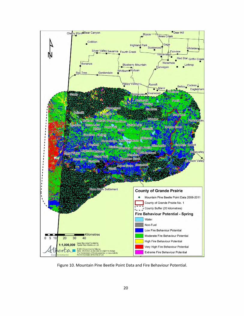
5. Mountain Pine Beetle Concerns
Mountain pine beetle management and a healthy pine approach have been a goal in the County of
Grande Prairie since beetles were discovered in 2006. Figure 10 displays point data of mountain pine
beetle attack within the county. Caution must be use in interpreting the point data as it may be for
individual trees as well as patches of trees. In order for the points to show up in figure 10, they were
increased in size and thus, over-emphasized.
Some stands of pine had 75 percent or greater mortality. In 2006, AF and the County immediately
started a control program both on private and crown land in the County. The County took the lead to
control the MPB by organizing and managing the South Peace Municipalities which included the
Counties of Grande Prairie, Saddle Hills and Birch Hills and the MDs of Greenview and Spirit River. The
control work involved both single tree removal and harvesting small patches of heavily infested pine
stands and in selected areas like Evergreen Park included the placement of pheromone patches to
protect key, high value pine stands. The infestation continues today but at a reduced rate. The majority
of the infested stands are now in the grey stage.
In 2010 the MPB management program moved towards becoming a FireSmart fuel management
program. Reducing fire hazard and risk in heavily infested MPB stands was identified as the priority. As
summarized in Table 2 and displayed on Figures 12 and 13, the County harvested and treated 752

19
hectares from 2010 to 2014 including grazing leases east of Bear Creek (Glen Leslie) and the lands
owned or leased by The Grande Prairie Regional Agriculture and Exhibition Society (Evergreen Park).
Another 140 hectares were harvested or treated in 2014 and 2015, with more harvesting planned for
2016. However, the main objective was to create a fuel break2 between Evergreen Park to the Aspen
Ridge rural subdivision and Bear Creek.
The costs of these projects were supported by grants predominantly from AF. However, approximately
80% of the total costs were recovered by selling merchantable fibre to the local forest industry. Actual
harvest and hauling costs were normally covered by the revenue of selling the saw logs or pulpwood.
The grants were used to cover items such as Annual Operating Plan development, Historical Resource
Value surveys, supervision and the extra costs associated with harvest in the sensitive sand dunes--extra
restoration work done in the summer following harvest to ensure prompt re-vegetation and stabilization
of the dunes or on grazing leases. For all projects from 2010 through 2015, the average net cost (total
cost minus the revenue from sale of logs) of fuel management projects was $2,568 per hectare.
Saw logs and pulpwood salvage harvested from Dunes North fuel management project.
2 The term “fuel break” used in this section and throughout this strategy refers to removing mature
stands of dead and dying trees to reduce the fuel loading to form a barrier to either prevent the spread of
wildfire or to increase fire suppression capability. In this strategy, this was accomplished by harvesting
small patches of merchantable stands or thinning non-merchantable stands and modifying the fuel type
from C-3 and C-2 to less flammable younger fuel types. Debris disposal was usually done by pile burning.
20
Figure 10. Mountain Pine Beetle Point Data and Fire Behaviour Potential.

21
Figure 11. Fire behaviour potential comparison for the spring, summer and fall seasons.
The spring season had the
greatest Fire Behaviour
Potential and was used for the
Hazard and Risk Assessment
portion of the County of
Grande Prairie Wildfire
Mitigation Strategy. The county
had the greatest amount of
moderate to high fire
behaviour potential in the
spring. The Fire Behaviour
Potential ranking takes into
consideration weather (as an
influence on HFI and fuel
condition), HFI, CFB and FBP
fuels.

22
Table 2. Fuel management treatments in the County of Grande Prairie.
Project Name
Treatment Year
Location Treatment Completed
by Area (ha)
Total Grant Funding Source
Glen Leslie 2010-2011
Glen Leslie, east of Bear
Creek
Salvage Harvest
Fall of 2011 129 0 -
Crown Fleck
Quarter 2010-2011
Dunes West
Salvage Harvest
Fall of 2011 35 0 -
Wapiti River
Corridor 2010 - 2013
Wapiti Sand
Dunes
Salvage harvest
Fall of 2013 419
801,460
AF*
Wapiti River
Corridor 2012 - 2013
Wapiti Sand
Dunes
Thinning plus
removal of blowdown,
debris
Fall of 2013 21
Fuel Reduction
and Mitigation
2013 Evergreen
Park
Single tree removal of dead trees and blow
down
Fall of 2013 140 95,000 AF
McComb Property
2013 West of Camp
Tamarack
Salvage harvest
Winter 2014
2 24,000 Alberta
Infrastructure
Evergreen Park
(South) 2013
Evergreen Park
Salvage harvest
Dec. 2013 6 0
Dunes North
2014
Between Hwy 40 & Resources
RD.
Thinning plus
removal of blowdown,
debris
End of 2015 95 945,700
FRIAA** (note:
committed funding,
project still in progress)
Aspen Ridge
2014
South of Aspen Ridge
Subdivision
Thinning plus
removal of blowdown,
debris
Summer 2015
45 424,434
FRIAA
892 $2,290,594
Net cost of fuel management treatments: $2,568 per hectare
*Alberta Agriculture and Forestry ** Forest Resources Improvement Association of Alberta

23
Figure 12. Map illustrating all areas that have been harvested or treated since 2010 as outlined in Table 1.
County Fuel Management Projects
2010-2015 – Salvage Harvest and Thinning

24
Figure 13. Fuel breaks located in the Wapiti Sand Dunes Area.
Fuel Break – Wapiti Sand Dunes
Salvage Harvest and Thinning by Year

25
6. Sub-Area Evaluations
As outlined in this document, the County has identified additional FireSmart projects for the future years
including fuel management to key areas and a number of items around public education, training, fire
suppression capacity and municipal planning (by-laws). However, before proceeding with new and
substantive FireSmart initiatives (especially those requiring provincial funding), it would be worthwhile
to review the projects done to date and to determine the value for the dollars spent to reduce wildfire
hazard and risk.
Recommendations Timing Responsibility
1. Complete an assessment of all fuel management and other FireSmart projects to date to determine the effect on fuel types, fire hazard and risk and protecting identified values-at-risk as outlined in this strategy.(note: this cannot be done until the FBP Fuel Type map is updated as noted in Recommendation #17)
Q2 2016 (Subject to the completion of Recommendation 17)
Community Services, AF
Seven sub-areas were identified and analyzed for fire hazard and risk. Main factors considered
included timber type (both age and species), topography, population (number and density of
residents) and industrial and infrastructure development (either embedded or adjacent; both
commercial and recreational). For each sub-area, an overall risk rating—which also captured hazard
was assigned: low, medium or high. Only those sub-areas with a medium or high rating are
recommended for future FireSmart projects.
Webster. This sub-area is generally classified as mature boreal mixed wood with less than 50%
coniferous. It is along the northern border of the County at the foot of the Saddle Hills. The
northern portion of this sub-area is crown land and part of Weyerhaeuser’s Forest
Management Agreement Area (FMA). The majority of the mature pine blocks in this area were
sequenced and harvested as part of Weyerhaeuser’s MPB Mitigation Program. This was
completed in 2010. The remaining forest is mostly aspen and mature spruce. Weyerhaeuser is
currently designing cut blocks for additional harvesting in 2015-16. The company is currently
participating in a MPB rehabilitation project in the Saddle Hills where unmerchantable and
infested pine stands are being harvested and piled and burned with the sites eventually being
planted.3 This will greatly reduce the fire hazard for the Saddle Hills and adjacent areas by
removing fuel and changing the age structure of the forest. Private farm land make up the
southern portion of this sub-area. Population is relatively low, although there are three rural
3 Interview and email from Traci Carter, RPFT, Strategic Forest Planning, Weyerhaeuser, Grande Prairie.

26
subdivisions on the south border of this sub-area. Infrastructure is mainly roads and utilities
serving the farms and residents in the area.
Fire risk for this area: Low
Homestead. This sub-area is generally classified as mature boreal spruce and pine. Most of this
sub-area is north of the County boundary and is within the County of Saddle Hills. The
adjacency to the County means the fire hazard and risk factors still need to be evaluated. The
part of the sub-area north of the County’s boundary is part of Weyerhaeuser’s FMA. The
majority of the mature pine stands in this area were sequenced and harvested as part of
Weyerhaeuser’s MPB Mitigation Program. This was completed in 2010. The remaining forest is
mostly aspen and mature spruce. Weyerhaeuser is currently planning cut blocks for additional
harvesting in 2015-16. The company is currently participating in a MPB rehabilitation project in
the Saddle Hills where un-merchantable and infested pine stands are being harvested and piles
burned and the sites planted.4 This will greatly reduce the fire hazard for the Saddle Hills and
adjacent areas by reducing fuel and changing the age structure of the forest. To the south is
private farm land with a relatively low population density. Infrastructure is mainly roads and
utilities serving the farms and residents in the area. There are a few scattered pine stands that
have been infested with the MPB on both private and crown land along the north boundary of
the County.
Fire risk for this area: Low
Typical landscape near Homestead – farm land and aspen stands bordering the boreal forest to the
north.
Updike Lake. This sub-area is mostly aspen with some boreal spruce and pine scattered
throughout. The area is a mix of crown land and private farms. The energy sector is a key
feature on the landscape with many well sites, pipelines and compressor stations. The area
borders Weyerhaeuser’s FMA. The majority of the mature pine stands in this area were
sequenced and harvested as part of Weyerhaeuser’s MPB Mitigation Program. This was
completed in 2010. The remaining forest is mostly aspen and mature spruce. Weyerhaeuser is
4 Traci Carter

27
currently sequencing cut blocks for additional harvesting in 2015-16. The company is currently
participating in a MPB rehabilitation project in the Saddle Hills where unmerchantable and
infested pine stands are being harvested and piled and burned and the sites planted.5 This will
greatly reduce the fire hazard for the Saddle Hills and adjacent areas by removing fuel and
changing the age structure of the forest. Other infrastructure includes roads and utilities to
service the farms, industry and residents in the area. Population is relatively low. There are
scattered stands of pine that have been heavily infested with the MPB.
Fire risk for this area: Low to Medium
Energy sector road west of Goodfare – aspen stands with some spruce understory
Calahoo. This sub-area is located in the very southwest corner of the County, north of the
Wapiti River and east of the BC border. This area is part of Weyerhaeuser’s FMA. The majority
of the mature pine stands in this area were sequenced and harvested as part of
Weyerhaeuser’s MPB Mitigation Program. This was completed in 2012. The remaining stands in
this area are mainly aspen and mature spruce or unmerchantable or immature pine.
Weyerhaeuser is currently designing cut blocks for additional harvesting after 2015-16.6 Areas
5 Traci Carter 6 Traci Carter

28
immediately to the north of this sub-area are either vacant crown land with deciduous forest or
private farm land.
Fire risk for this area: Low
Red Willow River. This sub-area is generally classified as mature boreal spruce and pine. It is
located just west of the Beaverlodge River and north of the Wapiti River. The crown land in this
sub-area is mostly managed as grazing leases by the North Wapiti Stock Association. Past
harvest for local uses (Commercial Timber Permits [CTPs]) has removed most of the mature
stands that were infested with MPB. Some additional coniferous stands are still available for
harvest for local use or firewood and would further reduce the fire risk. There is limited
infrastructure in the area and population is relatively low.
Fire risk for this area: Low to Moderate
Wapiti Sand Dunes. This sub-area is generally classified as mature pine and boreal spruce (C-3
and C-2 fuel types). It is located in a long band just north of the Wapiti River from the Smoky
River to Pipestone Creek. The sub-area is characterized by a series of large sand dunes with
open and treed muskeg in between. The sand dunes are covered by pine stands from 80 to 100
years of age that have been heavily infested with MPB. The banks of the Wapiti River are steep
and bisected by a number of smaller creeks and ravines. The banks are predominantly aspen
with open grassy slopes. Level 17 control work for MPB was conducted throughout this sub-
area from 2007 to 2010. Salvage harvest of heavily infested pine stands was completed on 419
hectares between 2010 and 2013 and an additional 21 hectares were thinned. Two FireSmart
fuel management projects funded by FRIAA were completed in 2015. Although mostly crown
land, there are areas of embedded private land including two rural sub-divisions. Another 12
rural subdivisions are immediately adjacent to this sub-area. There are at least five private
cabins on the banks of the Wapiti River (recreational leases). The area contains a number of
industrial sites including two industrial parks, a pulp mill, sawmill, chemical mill and a several
active gravel pits. The area is used by a number of community groups including the Peace Area
Riding for the Disabled Society (horse riding school), church and scout camps and nordic skiing.
The sub-area also has a privately owned golf course and two campgrounds and Evergreen Park
which is home of a number of community groups. Other infrastructure includes two main
highways, rail line and power and pipe lines. The area is used for a number of recreational
activities such as off roading with a variety of all-terrain vehicles (ATVs), horseback riding, dog
walking and hiking. The north boundary of this sub-area is immediately adjacent to the south
boundary of the City of Grande Prairie. The population is relatively high compared to the other
sub-areas in the County.
Fire risk rating: High
7 Individual or single tree treatment of pine trees infested with the Mountain Pine Beetle; could include but
not limited to grinding, peeling, burning.

29
Glen Leslie. This sub-area is generally classified as mature pine and boreal spruce. It is located
east of Bear Creek and north of the Wapiti River. Most of the area is crown grazing leases.
Approximately 129 hectares was harvested in 2010-11 to remove heavily infested pine stands.
Previously, there had been extensive Level 1 MPB control work completed throughout the sub-
area. The harvesting included enhanced debris disposal to promote grass production and to
reduce risk to grazing cattle. The area to the north is mostly private farm land. Two small rural
sub-divisions border crown land in this sub-area. Risk to homes or infrastructure is relatively
low, however, the remaining mature pine stands in the sub-area do offer some fire risk.
Fire risk rating: Low to Medium
7. Stakeholders
7.1 Alberta Agriculture and Forestry (AF)
Since 23 percent of the County is public land, AF is a key stakeholder in implementing a county wide
Wildfire Mitigation Strategy—especially in areas located in the Forest Protection Area . They are also
a key partner wildfire education, prevention and fire suppression. As displayed on Figure 14,
responsibility for forest protection is divided with AF responsible for the Forest Protection Area and
the County responsible for the non-forest protection area. AF and the County signed a Mutual-Aid
Agreement in 2009 which is updated yearly with the “Annual Mutual Aid Fire Control Plan”.
Figure 14. Forest Protection Area within the County of Grande Prairie (red cross hatching).

30
7.2 First Nations
The County will consult with First Nations in accordance with the Government of Alberta’s guidelines
on Consultation with First Nation on Land and Natural Resource Management.
The crown land in the County is part of traditional territory for the Horse Lake First Nation (HLFN).
The County will engage with HLFN for their input into the Wildfire Mitigation Strategy for the
County. The consultation approach will be as follows:
1. Notification package to the First Nation(s)—as identified in the pre-consultation assessment by
Alberta Aboriginal Relations —by sending an information package and notification letter to the
official First Nation consultation contact located at (http://www.aboriginal.alberta.ca/576.cfm).
The information package will be submitted electronically as one PDF document or in hard copy
by registered mail to Horse Lake First Nation. The information package will include:
1.1. Plain language documentation describing the proposed activity, its location, and its
potential short- and long-term adverse impacts
1.2. A map that clearly illustrates the location of the proposed project in relation to any easily
identified or commonly known landmarks (e.g., settlements, rivers, lakes, roads);
1.3. The expected life of the project (including timeline)
1.4. A site map that clearly illustrates the nature, scope, and magnitude of the proposed activity
(e.g., basic linear measurements and aerial dimensions, existing and proposed facilities,
means of access and egress); and
1.5. A detailed sketch of each activity and overall project plans with ATS legal locations
representing the project;
1.6. Any information provided by the Government of Alberta about potential First Nations’
concerns in the area (e.g., if the project has a HRV4c listing in the area.
1.7. Request from with First Nations for meeting further understand any concerns
2. A record of consultation Log (ROC) for each First Nation consulted using ROC log template
consistency across the province located at http://esrd.alberta.ca/forms-maps-
services/forms/lands-forms/esrd-forms/documents/FNC-RecordofConsultationLog-Feb27-
2013%20B.pdf.
2.1. This will include a complete, detailed, and accurate chronological account of the
consultation activities, including all successful and unsuccessful efforts to engage and/or
consult and any supporting documentation (emails, letters, meeting minutes, memos,
etc.).8
8 Email from Glenn Sorenson, Regulatory Consultation, Aboriginal Relations, dated March 11, 2015
31
7.3 Industry
There are a number of industrial sites in the County including the forestry and the energy sectors.
Most are located on private land in the non-forested parts of the County that are not directly
threatened by wildfire or on crown land in forested areas that have a low risk (aspen forests).
However, several major facilities including a pulp mill, a sawmill, gas plants and pipelines are located
on or adjacent to forested crown land and their input and cooperation with a Wildfire Mitigation
Strategy is one of the keys to successfully managing the wildfire risk. Key industrial stakeholders
include:
Weyerhaeuser
Conoco Philips
CN
ATCO
Canfor
Chinook Energy
ERCO
Wapiti Sand and Gravel
TransCanada
Knelsen Sand and Gravel
Recommendations Timing Responsibility
2. Provide copies of the approved Wildfire Mitigation Strategy to all major industrial companies in the County and a letter from Council promoting a cooperative approach to reduce the risk of wildfire
Q1 2016 Community Services
7.4 City of Grande Prairie
Although the threat of wildfire to the City of Grande Prairie is relatively low, the south and southeast
boundaries of the City are bounded by forested private and crown land. As the City grows and
expands to the south, this threat will increase. The City should have the opportunity to review and
provide input into this plan.
Recommendations Timing Responsibility
3. Share final document to the City of Grande Prairie
Q1 2016 Community Services
4. Share subsequent amendments and updates
On-going Community Services

32
7.5 Communities (towns, villages, hamlets and rural sub-divisions)
There are three towns, one village and five hamlets in the County. None of these communities
border forested crown land. However, all communities regardless of size and location should assess
their values-at-risk and complete an assessment of their risk from wildfire—especially grass fire risk
and hazard. Based on this assessment, each of these communities should prepare a Wildfire
Preparedness Guide specifically addressing their risk factors. All communities within the County will
be encouraged to assess their hazard and risk. The County will facilitate this process and assist
where required.
There are 76 named rural subdivisions and 15 industrial/commercial parks in the County. Most of
these subdivisions and commercial parks are located near cultivated land or aspen forests and the
risk of wild fire is low. However, 18 are surrounded by or border forested crown land that is
coniferous fuel types. The risk of wildfire varies considerably due mostly to the age and condition of
the adjacent forest type. Since the sand dunes area is allocation favoured for such developments,
wildfire hazard and risk for these subdivisions and parks is moderate to high. Therefore, a co-
operative planning approach involving the County, AF and private land owners will be required to
reduce overall fire risk and to achieve FireSmart objectives.
Recommendations Timing Responsibility
5. Rank all communities in the County for risk of wildfire including grass fires
Q2 2016 Community Services
6. Identify communities that require a “Wildfire Preparedness Guide” that would support the overall County strategy
Q2 2016 Community Services
7. Complete “Wildfire Preparedness Guides” with communities identified in Recommendation 5; and include a “values-at-risk assessment”
Q2 2017 Community Services plus impacted communities
8. Share final Wildfire Mitigation Strategy with all communities in the County, as well as neighbouring municipalities
Q1 2016 Community Services
9. Share subsequent amendments and updates
On-going Community Services
7.6 Saddle Hills County
The Saddle Hills County forms the north boundary with the County. This boundary is mostly crown
land that is part of Weyerhaeuser’s FMA. As noted earlier in this document, most of the mature pine
stands in the Saddle Hills have been harvested or are being rehabilitated as part of Weyerhaeuser’s

33
MPB strategy. This has helped reduced the overall wildfire threat in the Saddle Hills and the threat
to adjacent farms and infrastructure in the very north portion of the County. However, there are
scattered stands of infested pine on or immediately north of the border with Saddle Hills County.
The two counties should work together with AF and Weyerhaeuser to identify and to rehabilitate
these stands.
Recommendations Timing Responsibility
10. Identify high risk stands on the border between the Counties of Grande Prairie and Saddle Hills
Q2 2016 Community Services
11. Develop a plan to harvest or rehabilitate these stands to reduce landscape level fire hazard
Q3 2016 Community Services, Saddle Hills County, Weyerhaeuser and AF
7.7 Municipal District of Greenview No. 16
The M.D. of Greenview and the Wapiti River form the south boundary with the County. Although
the Wapiti River provides a natural fuel break, there are stands of mature pine and spruce on crown
land that are a risk factor especially along the Hwy 40 corridor. This area is also located in
Weyerhaeuser’s FMA. The County and M.D. along with Weyerhaeuser and AF should explore
opportunities to schedule harvest in these stands.
Recommendations Timing Responsibility
12. Identify high risk stands along Hwy 40 south of the Wapiti River and in the M.D. of Greenview No. 16.
Q3 2016 Community Services
13. Work with Weyerhaeuser to develop a plan to log or rehabilitate these stands to reduce fire risk
Q4 2016 Community Services, AF and Weyerhaeuser
7.8 Community Groups
The County and the City of Grande Prairie have a large number of community and non-profit groups
that promote a variety of recreational, cultural and educational activities. Many of their facilities are
located on crown land or their activities occur on crown land. This covers a range of activities and
uses from hiking, horseback riding, hunting, summer camps and ATV use. These activities and uses
can increase the wildfire ignition risk. However, these same groups also offer an opportunity to
educate users about FireSmart and wildfire prevention, to engage people or groups in FireSmart
projects and to monitor activities on crown land that increase wildfire risk. The County held an open
house in March 2015 to provide community groups and local residents with the opportunity to
provide input into the draft strategy and to raise any concerns or issues.
34
Recommendations Timing Responsibility
14. Identify stakeholders that are active or have facilities in the highest risk areas; share final document
Q2 2016 Community Services and Planning Services
15. Look for opportunities to encourage FireSmart practices and share information
On-going Community Services and other County departments
7.9 Wapiti Corridor Planning Society (WCPS)
The WCPS was formed in 2009 to create a multi-use plan for the Wapiti River Corridor from the
confluence of the Smoky and Wapiti Rivers to Pipestone Creek. The main purpose of the plan was to
promote sustainable land use and to balance both current and future needs of the area and its
people. The plan was submitted to the Government of Alberta in December of 2013. Although it has
not been approved, it makes numerous recommendations around land use and access
management; some of these recommendations have a direct impact on wildfire risk. The WCPS also
has ongoing involvement and input from a number of user groups that are active in the Wapiti River
Corridor. The area of highest concern for the WCPS--the Wapiti Sand Dunes is within the area
identified in this strategy as having the highest wildfire risk in the County. There is an opportunity
for the County and the WCPS to work together on common issues around access management that
would both provide for the needs of recreational users and the need to reduce wildfire risk.
Recommendations Timing Responsibility
16. Work with the WCPS and the Wapiti Dunes Development Society to manage access in the Wapiti Sand Dunes
On-going Community Services, WCPS, AF
8. Values-at-Risk - General
County-wide, there are numerous values-at-risk. Such values include standard values-at-risk (homes
and other residential structures), critical infrastructure values (values that provide critical services to
the planning area) and special values -at-risk (natural, cultural or historic values such as cemeteries
or historical buildings)..
Education of the public and private land owners on how to reduce their exposure to the risk of
wildfire is a key element of FireSmart. The County has promoted FireSmart through a number of
initiatives including workshops for residents, information booths at trade shows and wood chipping
demonstrations. The County continually provides information on FireSmart through their
newsletters, mail outs to residents, news releases and their website. As outlined throughout this
document, most of the County is private farm land with a cured grassfire risk (spring and fall). The

35
23 percent of the County that is crown land varies from low to extreme fire behaviour potential
depending on the season, the forest cover type and other wildfire indices.
Fire behaviour potential, head fire intensity, rate of spread and crown fraction burn--as well as MPB
infestation indicators for key areas of concern. The crown land along the western border with British
Columbia and the north border with the Saddle Hills County is predominately mature aspen with
scattered pockets of mature spruce and pine. The aspen stands generally have a low stocking of
coniferous understory. The risk rating for aspen is generally low for both fire starts and for spread,
intensity and the potential for crowning—however, prior to spring green-up and bud flush, these
stands can be problematic if a wildfire ignites. These same areas also include a number of grazing
leases that have not generally been cleared to promote grass production. The southwest corner of
the County is part of the Weyerhaeuser’s FMA. Harvest in this area has removed most of the mature
pine stands. To the north of their FMA are mostly aspen stands on vacant crown land or cleared
private land. Depending on the season, the cultivated land can acts as a buffer between the FMA
and the rest of the County. The north boundary of the County is the Saddle Hills and
Weyerhaeuser’s FMA.
The lower slopes of the Saddle Hills which form the actual boundary of the County are
predominately aspen stands with only scattered patches of infested pine. Fire behaviour potential
along the north boundary is generally low to moderate. The highest risk area in the County is the
wide strip of crown land just north of the Wapiti River between Bear Creek and Spring Creek. This
area has the heaviest concentration of mature pine and was the area most heavily infested with the
MPB. It is also the area used mostly for a variety of recreational activities including ATVs and has the
heaviest concentration of rural subdivisions. Due to these factors, this is the area that has the
highest priority for the County and AF for FireSmart fuel management projects in order to reduce
the overall fire hazard and risk.
This area also contains a mix of industrial development including a pulp mill, sawmill, well sites,
pipelines, transmission lines, gravel pits, grazing leases and a rail line. Most of these developments
add little to the fire risk due in part to their location, their activity or their own fire prevention or
suppression capabilities. The one exception to this is the CN rail line that runs through this area from
the pulp mill to the City of Grande Prairie-- records of fire starts and causes within the County are
limited, but anecdotal evidence points to the rail line as a high risk for fire starts.
As stated above, this area is very popular for a variety of summer recreational activities including off
road vehicles. Fire starts from ATVs, campfires and other human-causes is a high risk factor for the
area.
The western portion of the County bordering British Columbia is mostly aspen and the fire
behaviour potential is generally low to moderate. However, immediately west of the border in
British Columbia, there are large areas of coniferous forests that potentially could be a fire risk to
the County. There has been increased harvest in this area due in part to the priority of salvaging pine

36
stands infested with the MPB. The County and AF should work with the Ministry of Forests, Lands
and Natural Resource Operations in BC to identify any areas of concern, and if necessary, promote
fuel management projects to reduce overall fire hazard and risk.
The most critical season for the area is the spring period between snow melt and green-up.
Depending on the snow pack, the level of spring run-off and weather conditions the spring fire
season can last from a few days to a month or greater and the fire danger rating can vary from low
to extreme. Normally, the highest hazard and risk for fire (both in terms of starts and in intensity) is
during this period of time. All forest and cultivated vegetation can be susceptible to fire at this time-
-including tamarack and black spruce, treed and open muskegs and grasslands.
As compared to forested areas south of the Wapiti River, lightning is not a major factor in starting
wildfires in the County. Although records are limited, anecdotal evidence does not point to a high
incidence of starts from lightning. Also, most lightning events are accompanied by rain as compared
to dry lightning storms which are more common in other parts of Alberta.
Grande Prairie averages 287.1 millimetres of rain during the summer from the beginning of May to
the end of September with June and July being the wettest month. Average snow depth at the end
of March is 13 centimetres, although this would be higher in forested areas. Average wind speed is
11 to 14 km per hour and generally from the west although maximum gusts can be from the SE to
SW.9 It is not uncommon to have periods of hot, dry weather in July through early September which
can lead to a later fire season. And this is the most likely period for the occurrence of dry lightning
storms.
Another complicating factor in this area is the MPB. The infestation started in the summer of 2006
and rapidly spread throughout the mature pine stands in the Wapiti Sand Dunes. A control program
was initiated by AF in the fall of 2006 and included both Level 1 activities and salvage harvest of the
hardest hit stands. The MPB program had a varying impact on fire risk. Fuel loading was reduced in
many areas (especially stands that were salvage harvested) but some areas of Level 1 projects saw
increased fuel loading from slash accumulation. These stands are now mostly in the grey stage and
lower fire hazard (compared to the red stage); however, this hazard will increase again as the stands
start to blow down and there is an accumulation of stems and slash on the ground.
Another fire risk factor is the increased access for ATVs due to harvest and current fuel management
activities or projects in the Dunes. As trees are removed (both as single trees or in small patches),
this increases access for ATVs and increases fire risk both from the ATV (sparks from the muffler and
vegetation collecting on engine parts) and unauthorized camp fires.
9Environment Canada Historical Weather Records, 1981- 2010; Grande Prairie Airport <http://weather.gc.ca>
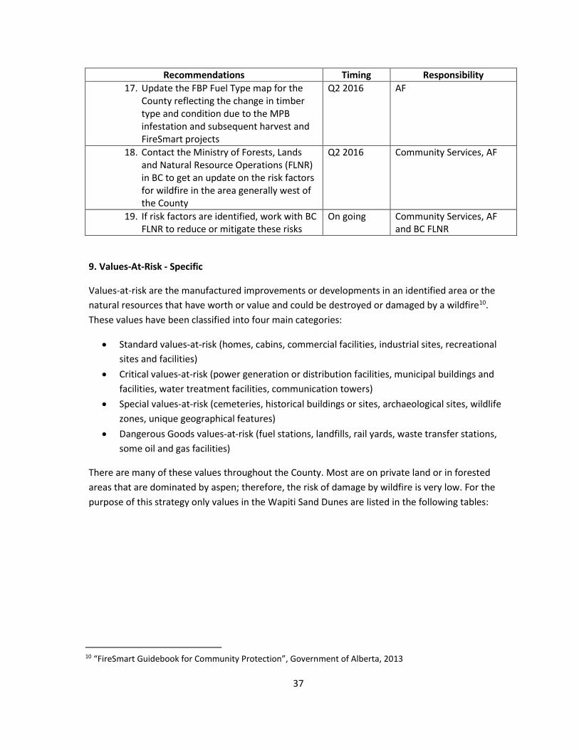
37
Recommendations Timing Responsibility
17. Update the FBP Fuel Type map for the County reflecting the change in timber type and condition due to the MPB infestation and subsequent harvest and FireSmart projects
Q2 2016 AF
18. Contact the Ministry of Forests, Lands and Natural Resource Operations (FLNR) in BC to get an update on the risk factors for wildfire in the area generally west of the County
Q2 2016 Community Services, AF
19. If risk factors are identified, work with BC FLNR to reduce or mitigate these risks
On going Community Services, AF and BC FLNR
9. Values-At-Risk - Specific
Values-at-risk are the manufactured improvements or developments in an identified area or the
natural resources that have worth or value and could be destroyed or damaged by a wildfire10.
These values have been classified into four main categories:
Standard values-at-risk (homes, cabins, commercial facilities, industrial sites, recreational
sites and facilities)
Critical values-at-risk (power generation or distribution facilities, municipal buildings and
facilities, water treatment facilities, communication towers)
Special values-at-risk (cemeteries, historical buildings or sites, archaeological sites, wildlife
zones, unique geographical features)
Dangerous Goods values-at-risk (fuel stations, landfills, rail yards, waste transfer stations,
some oil and gas facilities)
There are many of these values throughout the County. Most are on private land or in forested
areas that are dominated by aspen; therefore, the risk of damage by wildfire is very low. For the
purpose of this strategy only values in the Wapiti Sand Dunes are listed in the following tables:
10 “FireSmart Guidebook for Community Protection”, Government of Alberta, 2013

38
Table 3. Standard Values-at-Risk.
Name Location (legal) Owner Type of Facility
Assessment Value ($000)
On site Fire Risk
(L,M,H)
Adjacent Fire Risk (L,M,H)
Comments
Wapiti Ridge SE 20,70,3,W6 private subdivision 3,400 L L Mostly aspen and open fields
Crystal Creek Acres parts SW,SE 24, 71,4,W6
private subdivision 6,803 L L Mostly aspen, some scattered spruce on south lots and boundary
Aspen Ridge W 13,71,5,W6 private subdivision 28,663 L M Risk has been reduced by previous and current FireSmart projects
Sunridge Estates SE 13,71,5,W6 private subdivision 3,584 L M Risk has been reduced by previous and current FireSmart projects
Arthur Lane SE 14,71,5,W6 private subdivision 10,557 L L Mostly open with aspen; south of road is field; south of field is crown land with pine and spruce along Bear Creek
Bear Ridge Estates parts SE 9,71,5,W6
private subdivision 6,860 L L - M Mostly open with aspen along south boundary; adjacent to Bear Creek with spruce
Taylor Estates SW 8,71,5,W6 private subdivision 46,852 L L – M Spruce, aspen mix with lots of open areas; most dead pine has been removed; open field to the east; Phase III to the east mostly open field
Pine Valley Estates NW 5,71,5,W6 private subdivision 14,469 M H Most of the bigger pine has been removed; younger pine remaining; now more aspen overall; Pl40Sw30A30; borders Bear Creek to south and east
Wedgewood Estates NE 1,71,6,W6 private subdivision - L M Borders Bear Creek with spruce; all roofs have wood shakes
Dunes parts NW,NE 25, 70,6,W6
private subdivision 15,563 M H Mostly spruce in NW corner (Sw70A20Pl10); mix cover along county road (Pl40Sw30A20Lt10); open for Dunes on 17th.
Dunes on 17th NE 25,70,6,W6 private subdivision 13,700 L L Mostly open with aspen along south border
Tamarack Estates parts NE private subdivision 20,051 M M West side lots of tamarack, black spruce

39
6,70,6,W6 (Lt50Sb40A10); east side, more pine on north side, more aspen on south side. Aspen along south boundary; pine on north boundary, but heavily thinned due to MPB
Sandy Lane Estates NW 35,70,6,W6
private subdivision 6,301 L L Mostly aspen with scattered spruce; FireSmart projects to south and east has removed most risk
Mandalay Estates NE 25, 70,6,W6 private subdivision 2,287
L M Mixed aspen and spruce; only moderate due to proximity to rail
Dunes West SW 21,SE 20,70, 6,W6
private subdivision 15,190 L M A with SW understory, open areas in east portion; Pl, T, SW in west portion; A on south boundary (edge of bank) with scattered dead pine
The Ranch NE 20,70,6,W6
private subdivision 6,070 L L T, SW, Sb, A within sub-division
Deer Ridge Estates SE 29,70,6,W6
private subdivision 14,300 M H Pl, A, SW within boundary; some dead pine removed by landowners; grazing lease to east with considerable dead Pl
Mystik Ridge SW 29,70,6,W6
private subdivision 6,272 L L A80Sw20; typical aspen site with little chance of wildfire
Riverview Pine Estates
parts SE,SW26, 70,7,W6
private subdivision 14,608 L - M M A80Sw20; most of the dead pine has been removed; some pine to east, but mostly surrounded by aspen
Wapiti Nordic Ski Club
Parts SW,SE27, NW,NE22,70,6,W6
Wapiti Nordic Ski Club
recreation - M M Previous MPB Level has thinned out the pine; still mostly coniferous forest with standing dead
Scouts Canada SW 27, 70,6,W6 Summer camp
- M M Embedded in lease operated by the Wapiti Nordic Ski Club
Pineridge Camp NE 27, 70,6,W6 Grande Prairie Church of Christ
summer camp
- M M Embedded in lease operated by the Wapiti Nordic Ski Club
Camp Wapiti SE 25,70,6,W6 Mclaurin Baptist Church
summer camp
- L - M L - M Some scattered pine in and around camp
Camp Tamarack parts NW26,70,6, Camp - 1,298 L L Previous MPB and FireSmart work has

40
W6 Tamarack Association
removed most of the dead pine; current project to the north has further reduced risk
Wapiti Shooters Club
SE 36,70,6,W6 Wapiti Shooters Club
recreation - L L Previous MPB and FireSmart work has removed most of the dead pine; current project to the west has further reduced risk
Evergreen Park 31, W32,70,5,W6 Grande Prairie Regional Agricultural & Exhibition Society
- - L L – M Previous MPB and FireSmart work has removed most of the dead pine; area is still mostly green but needs to be monitored for additional MPB infestation
PARDs parts SW5,71,5,W6
- - L L - M MPB work to north and FireSmart to the east and within Evergreen Park have removed most of the risk
McGovern's RV & Marine Campground
NW 31,70,5,W6 Grande Prairie Regional Agricultural & Exhibition Society
recreation - L L - M Located in Evergreen Park
Archery Range NW 31,70,5,W6 Game County Archers
recreation - L L - M Located in Evergreen Park
Peace Draft Horse Club
NW 31,70,5,W6 Peace Draft Horse Club
recreation - L L - M Located in Evergreen Park
Grande Prairie Minor Baseball Association
NW 31,70,5,W6 Grande Prairie Minor Baseball
recreation - L L - M Located in Evergreen Park

41
Association
Evergreen Centre for Resource Excellence and Innovation
NW 31,70,5,W6 Grande Prairie Regional Agricultural & Exhibition Society
research - L L - M Located in Evergreen Park
Dunes Golf and Winter Club
NE 25, 70,6,W6 private recreation - L L - M Most dead pine within park has been removed; FireSmart projects to north has removed most risk
Camp Tamarack RV Park
NW 26, 70,6,W6 private recreation 1,274 L - M L – M Most dead pine within park has been removed; FireSmart projects to north and east has removed most risk
Minhas Industrial Park
NW, NE 36, 70,5,W6
private industrial - L L Now low due to current FireSmart projects to the south
County Industrial Park
SW, SE 1, 71,6,W6 private industrial - L L - M Borders Bear Creek with spruce
Grande Prairie Golf and Country Club
SE 12, 71,6,W6 Grande Prairie Golf and Country Club
recreation - L L Between Wedgewood and City of GP; borders Bear Creek with some spruce
Paved hiking/walking trails
NW,NE 25, SE,NE 35, NW,SW 36, 70,6,W6
County - - L L Low due to previous and current MPB and FireSmart projects
Weyerhaeuser parts 14, 15, 16; 21,22,SE,SW,NW 23,70,5,W6
private industrial 99,325 L L – M Pulp and saw mills on industrial site; borders forested areas to the north at the top of the banks of the Wapiti River
ERCO Worldwide private industrial - L L Sodium chlorate plant on industrial site

42
Table 4. Special Values-at-risk
Name Location (legal) Owner Type of Facility
Assessment Value ($000)
On site Fire Risk
(L,M,H)
Adjacent Fire Risk (L,M,H)
Comments
Bear Creek Cemetery parts NW6,71,5, W6
County - - L L Dead pine previously removed
ACA Conservation Site
Parts SE18,NE 18, SE19,70 6
W6
Alberta Conservation Society
- - - - -
Table 5. Critical Infrastructure Values- at-Risk
Name Location (legal)
Owner Type of Facility
Assessment Value ($000)
On site Fire Risk (L,M,H)
Adjacent Fire Risk (L,M,H)
Comments
Main Transmission Line
ATCO M M
Water Treatment Plan
Aquatera Utilities
L L
Water pipeline Aquatera Utilities
L L - M
Electrical power sub-station
ATCO L L At the junction of the Canfor Haul Road and the Correction Line Road
Communications Tower
M M
CN rail and bridge across
CN Private rail and bridge
L L - M Main rail line to and from Grande Prairie

43
the Wapiti River
Hwy 40 Bridge Alberta Public bridge
L L Main highway accessing Grande Prairie from the south
Weyerhaeuser Bridge
Weyerhaeuser
Private bridge
L L private bridge but used by the public in emergency if Hwy 40 is closed
Canfor/Wapiti Gravel Bridge
Canfor and Wapiti Gravel
Private bridge
L L
Table 6. Hazardous Goods Values-at-Risk
Name Location (legal)
Owner Type of Facility
Assessment Value ($000)
On site Fire Risk (L,M,H)
Adjacent Fire Risk (L,M,H)
Comments
None identified at this time

44
As outlined in the tables above, private homes or residences are the single biggest risk category.
In the Wapiti Sand Dunes there are over 700 private residences in rural subdivisions and acreages
with an assessment value of approximately $400 million.
Although the priority for this strategy is to specifically identify values-at-risk in the Wapiti Sand
Dunes, it is recommended that each community within the County complete a similar
assessment as part of their Wildfire Preparedness Guide development.
10. Wildfire Suppression Capacity11
The County of Grande Prairie Regional Fire service has been in existence since 1951. On January 1,
2012 the Regional Fire Service model changed when they started providing around the clock
coverage out of two fully staffed fire stations in Clairmont and the Dunes area. In addition, there are
three rural stations in Bezanson, La Glace and Teepee Creek. These five stations have a total of 130
firefighting staff available to be deployed. The County also has four contract service providers from
municipalities within the County: Wembley; Beaverlodge; Hythe and Sexsmith. Each of these
stations provides fire response coverage to a portion of the County. These services add another 120
firefighters that could be tasked if required. In total there are over 45 pieces of apparatus, including
an aerial apparatus, engines, tenders, 4x4 units, off road vehicles, and structural protection units.
Approximately fifty percent of all of the County’s apparatus are 4x4s and have off road capabilities.
The Dunes Fire Station is located on Secondary Highway 668 immediately adjacent to the sub-area
identified as the Wapiti Sand Dunes—the area was also identified as having the highest wild fire risk.
This station is equipped with specific apparatus designed for fire suppression in the wildland-urban
interface, including one structural protection trailer equipped to protect up to 25 homes, one 4x4
truck designed for use in the trail systems of the Dunes, one 4x4 wildland engine with 2650 liters
and pump and roll capability, a tender with 11,350 liters of water, and an urban engine. It also has a
support 4x4 pickup truck and two Can-Am 800 quads available for deployment.
The County has a program of installing frost free stand pipes in rural water sources (mainly dugouts)
to provide a year round supply of water for firefighting. These stand pipes would also provide
additional water sources for fighting wildfires. These sources would require an engine to connect to
draw water up through the standpipe, and have been outfitted to allow the County’s large
apparatus to connect to them.
The County has initiated a program to train equipment operators in Public Works in basic firefighting
skills. This would increase the capacity of the County to fight wildfire that is not accessible by road
and to support ground and aerial firefighting crews with heavy equipment.
11 This section submitted by Everett Cooke, Fire Chief, County of Grande Prairie No. 1

45
The County of Grande Prairie No.1 has mutual aid agreements with AF and several municipalities
including the MD of Greenview and the towns of Beaverlodge, Sexsmith and Wembley, and the
village of Hythe.
The County also has a mutual aid agreement with Horse Lake First Nation (HLFN) and under this
agreement the County has worked with HLFN to significantly increase their fire response expertise
and capability.
Weyerhaeuser is the only private, industrial fire brigade in the County. There are a number of private
industrial fire response companies operating with the County of Grande Prairie. The County has a
close working relationship with some of these private brigades.
Recommendations Timing Responsibility
20. Provide firefighting training to all equipment operators in Public Works
Q2 2016 Fire Services
21. Identify and map water sources (large dugouts, lakes, etc.) that could be available for fighting wildfires
Q3 2016 and on-going
Fire Services
22. Identify heavy equipment owned and operated by the County that could be used for fighting wildfire
Q2 2016 Fire Services and Public Works
23. Continue to support the Weyerhaeuser private brigade through co-training
On-going Fire Services
24. Develop a list of private contractors/equipment to be used for fighting wildfire, updated annually
Q1 2016 and on-going
Fire Services
11. Ongoing Consultation
Consultation with the public and key stakeholders is an important part of implementing FireSmart at
all scales. This plan included extensive consultation with AF both for wildfire data and for their
expertise on wildfire and for creating a wildfire mitigation strategy. There was also consultation with
major industrial stakeholders including Weyerhaeuser, Canfor, ATCO, and ConocoPhillips. An open
house was held on March 18, 2015 to allow for input and comments from the public and local
community groups. All concerns and issues raised at the Open House have been addressed in the
Strategy.
There is also a need for ongoing consultation with the public as the strategy is updated or the risk of
wildfire changes. Besides ongoing communication from the County (newsletter, website, mail outs,
etc.), there needs to be a formal process for the public and community groups to get updated on the
strategy and to provide input on a regular basis.

46
Recommendations Timing Responsibility
25. Provide ongoing public input into the strategy and subsequent updates during the County’s annual open houses.
Annual Communications working with individual departments
12. Education and Communications12
Public education and communications plays a key role in promoting and implementing FireSmart principles and projects by:
increasing awareness among residents, business owners and public officials of the potential and scope of wildfire within the County;
increasing awareness about the potential and risk of grass fires on both private land and on adjacent crown land with grassland fuel types, and promoting prevention, especially during the spring fire season and prior to green up
promoting local FireSmart initiatives;
and supporting collaborative solutions among all stakeholders to mitigate the risk of wildfire. Over the past several years, there has been a strong focus on FireSmart education and awareness programs within the County of Grande Prairie in order to reduce and prevent the risk of wildfires and engage the public in taking preventative action. These public education strategies and corresponding communications ensure that all stakeholders are aware of the options available and have the information and tools to take proactive, preventative approaches to keeping their properties and families safe and free from wildfire. These include:
12.1 Public Education Events and Initiatives:
FireSmart booth and communications materials at the annual County Open House, as well as at third party trade shows in the region.
FireSmart Trade Fair to inform home and business owners on how to protect their property from wildfires. This event included workshops, fire department demonstrations and a trade fair featuring products/methods to help reduce risk of damage or wildfire.
Wood Waste Clean Up events at various locations throughout the County where residents can bring scrap wood debris, branches and deadfall for chipping. ESRD and County fire staff are on-site to answer questions.
Public wood chipping demonstrations showing how to properly chip wood waste and debris.
FireSmart information sessions on a range of topics including how to be FireSmart, how to FireSmart property, mountain pine beetle hazards, etc.
Public education sessions to provide information and updates about FireSmart work taking place near residential and recreation areas.
Seasonal Fire Patrol Officer (role commenced in 2014) to perform hazard assessments within the County and to assist in delivering the FireSmart education program.
Media tours and public education to keep the public informed and updated on work being done to create a fuel break to reduce and prevent the risk of wildfire. The County, in close
12 This section submitted by Lesley Nielsen-Bjerke, Communications Manager, County of Grande Prairie No. 1

47
cooperation with AF, has been removing dead and dying pine trees from crown land along the Wapiti River Corridor since 2006. In 2010, the principle objective switched from controlling MPB to reducing fire risk in key areas south of Grande Prairie and mitigating the likelihood of a large, high intensity fire through FireSmart.
The County of Grande Prairie has been in the process of FireSmarting a wood structure located at Evergreen Park (Old Timer’s Cabin). Subject to receiving further funding to complete the FireSmart work in and around the cabin, the County will use the building for FireSmart education through self-guided tours, with a potential to reach 500,000 people who attend Evergreen Park functions each year.
12.2 Communications and Information:
FireSmart messaging and information is distributed to the public and to targeted stakeholders through a variety of communication tools. These communications tools are attached as Appendix B, and include:
Articles in the County of Grande Prairie’s external newsletter
Brochures
Mail outs to promote FireSmart events
Face-to-face personal communications with targeted stakeholders and the general public
Information on the County website homepage and dedicated pages to FireSmart events, tips on how to be FireSmart, fire permits, safe burning practices, etc.
Newspaper and radio advertising
News releases and fact sheets
Social media
Service interpretive signage at fuelbreaks
FireSmart information to mitigate wildfire risks included within the County’s new resident welcome packages and in the “Guide to Rural Living”
Recommendations Timing Responsibility
26. Continue all public education and awareness initiatives and programs that have been implemented within the County of Grande Prairie, regularly assessing and updating them.
Q1 2016 and on-going
Communications and Fire Services
27. Develop a formal FireSmart Communications Plan to support the FireSmart Program within the County. This plan will identify target audiences, key messages, education/communication methods and tools, timing and budget.
Q3 2016 Communications and individual departments
28. Develop a specific program around the risk of grass fires targeting private land owners and with an emphasis on prevention
Q4 2016 Communications and Fire Services

48
29. Subject to receiving further funding to complete the FireSmart work in and around the Old Timer’s Cabin at Evergreen Park, this structure will be used for FireSmart education through self-guided tours. (Note: funding proposal will be submitted to FRIAA)
Q4 2016 subject to funding approval
Fire Services
30. County of Grande Prairie Planning Director or Senior Planner, Fire Chief, Fire Marshal and Communications Manager or designates to attend the annual FireSmart Community Series Workshop.
As available Community Services
31. Host a FireSmart Community Series Workshop in the region for developers, realtors, homebuilders, elected officials and various County staff departments to equip them with the tools, expertise, and contacts they need to help build a FireSmart region.
As available Community Services
32. Attend a FireSmart Local Community Representative workshop.
Completed; Oct. 27 and 28, 2015
County Councillors and FireSmart staff
33. Host FireSmart Community Champion workshops to engage private landowners
In progress, set for Feb. 26 and 27, 2016
Fire Services
13. Legislation
13.1 Provincial
AF, Alberta Environment and Parks (AEP) and the Alberta Energy Regulator (AER) are responsible for
dispositions and management activities on public land in Alberta including both the green and white
areas. Most of the public land in the County is in the white area except for the southwest corner and
along the west border with British Columbia. Wildfire responsibility in the County is shared with AF.
Generally, AF is responsible in the western portion of the County in the Forest Protection Area; with
the County responsible in the remainder including the Wapiti Sand Dunes. The County and AF have a
mutual aid agreement in place regarding firefighting and the County has a restrictive burning policy
(burning permits required at all times) for much of the Wapiti Sand Dunes.
Since the arrival of the MPB in 2006 and FireSmart fuel management projects in 2010, the landscape
of crown land in the County has changed drastically especially in the Wapiti Sand Dunes. A majority
of the pine is dead from the MPB and there have been a number of projects to reduce fuel loading
and to reduce fire hazard and risk. This strategy will be recommending additional fuel reduction
projects which will further modify the landscape and forest cover. One of the unintended

49
consequences of these projects is increased access to the sand dunes with ATVs and off road
vehicles. Unauthorized activities in the Wapiti Sand Dunes have been a long standing problem. This
includes littering, unauthorized dumping, unauthorized burning, environmental degradation of
sensitive sand dunes and wet areas and other activities that cause environmental damage and
increased risk of wildfire (from ATVs and unauthorized camp fires). The County has increased
enforcement in recent years including the hiring of seasonal staff to patrol designated areas.
Additional tools to control access would be beneficial for reducing environmental damage but also
reducing the risk of wildfire. The preferred means of doing this on vacant crown land in the white
area of Alberta is through Public Land Use Zones (PLUZ).
A PLUZ is used to manage industrial, commercial and recreational activities on a specific land base.
Normally, this is used to protect sensitive land or resources and to manage conflicting land use
activities. One of the key features of a PLUZ is that it provides the means to control the use of
motorized vehicles including ATVs by restricting their use to designated trails or roads13.
Recommendations Timing Responsibility
34. Investigate designating parts of the Wapiti Sand Dunes as a PLUZ to control off road access
Q1 2017 Community Services
35. Investigate the feasibility and practicality of reclaiming gravel leases for other uses while considering FireSmart principles
On-going Planning and Development, Parks and Recreation
13.2 Municipal14
Under the Municipal Government Act (MGA), County Council may pass by-laws regarding the safety,
health and welfare of people and the protection of people and property. All statutory plans and
bylaws must be consistent with the County’s land use policies. In making a decision as to whether to
approve an application for a subdivision, accessibility to a road, the use of adjacent land and any
other matters that may determine its suitability for a subdivision must be considered.
In the Municipal Development Plan Bylaw, AF has not identified any areas which are specifically
prone to flooding, erosion or wildfire. Land use bylaws may include fire protection in determining
the availability or adequacy of municipal services; state the width of fire lanes and maneuvering
aisles, and the use of exterior materials to reduce the risks of wildfire damage. Generally, no
changes are recommended for the County’s bylaws to reflect specific FireSmart initiatives.
13 “Public Land Use Zones” <http://esrd.alberta.ca> 14 Based on notes and emails from Cate Porterfield, Planner, County of Grande Prairie No. 1

50
Recommendations Timing Responsibility
36. Investigate and research what other municipalities have done to amend or update their bylaws to reflect FireSmart principles
Q1 2016 Planning Services
14. Development15
All rezoning and subdivision applications are circulated to the County’s Fire Marshall. It is required
that all rural developments have two access points for safety reasons. Comments from the Fire
Marshall are considered when Administration makes their recommendations to County Council or
the Municipal Planning Commission. The Planning Department is also responsible for approving
Development Permit applications and ensuring that development meets the Alberta Building Code.
The Alberta Building Code deals with the safety measures within a building; it does not contemplate
FireSmart initiatives. The County encourages FireSmart development and endeavours to provide
FireSmart booklets to new developments located in the Wildland-Urban Interface (WUI).
Recommendations Timing Responsibility
37. Include or consider FireSmart principles in the scheduled review of the County’s Land Use Bylaw
Q2 2016 Planning Services/County Council
38. Continue to provide information with new development permits when issued, and consider development of a comprehensive information package
Q1 2016 and on-going
Planning Services/FireSmart Committee/Community Services
15. FireSmart Activities
15.1 Fuel Reduction Recommendations and Proposals
Based on the hazard and risk assessment for the County in total and for the various sub areas
outlined above, the following fuel management projects have been identified. These are listed in
order of priority with the highest priority projects first and are shown on the on Figure 15, Figure16
and Figure 17. A general approach to reducing fire risk is outlined for each area; however, more
detailed field assessment will be required to determine the actual treatment areas and the actual
fuel reduction method or activity to be used:
1. Completion of the fuel break between Evergreen Park and Aspen Ridge to Bear Creek.
15 Cate Porterfield
51
This fuel break has been a top priority for both the County and AF. As outlined earlier in this
document. Salvage harvest commenced in the winter of 2010-11 and has now completed
approximately 419 hectares. In addition to the salvage harvest, 21 hectares were thinned in
2011-12 and another 45 hectares were thinned in 2014-15 as a FireSmart fuel management
project funded by FRIAA. Another estimated 132 hectares of salvage harvest is being planned for
the winter of 2015-16. See Figure 13 for details of areas harvested by year for this fuel break.
Once the salvage harvest is completed, the only remaining work for this fuel break will be fuel
reduction in the area shown in “blue” in Figure 15. This is the remaining unmerchantable stands
that need to be treated to complete the fuel break. The most likely option for fuel reduction will
be thinning by removing all dead and dying pine trees. However, detailed field work would be
required to confirm exact area of the stands to be treated and the best fuel reduction method
or methods.
Recommendations Timing Responsibility
39. Recon area and map stands for treatment
Q2 2016 Community Services (using existing AF grant)
40. Propose fuel reduction/modification project
Q4 2016 Community Services
Note: The blocks outlined in “green” below is scheduled for harvest in 2015-16. The blocks have
been located in the field and the salvage harvest and hauling was awarded to Tappen
Contracting in October 2015. A purchase log contract has been signed with Weyerhaeuser and
harvest will begin as soon as weather and ground conditions permit. If the salvage operation is
completed by March 31, 2016 as planned, 6 blocks and 132 hectares will be harvested and will
complete work in this area except what has been identified above in Recommendations #39
and #40. Any final clean up and restoration work on these blocks would be completed in the
summer or fall of 2016. All harvest and hauling costs are covered by the sale of the pulp and
saw logs to Weyerhaeuser; all additional costs (layout, supervision, restoration, etc.) are
covered by existing AF grants.

52
Figure 15. Outline of remaining area to be treated (outlined in blue) in relationship to previous and current FireSmart fuel management
projects.
Fuel Break – Evergreen Park to Aspen
Ridge and Bear Creek

53
Figure 16. Detailed view of area to be treated to complete the fuel break.

54
Figure 17. Current FireSmart project south of Aspen Ridge. Northeast end of fuel break.

55
2. Fuel Reduction along Bear Creek from the City of Grande Prairie to Range Road 51.
Bear Creek more or less separates crown land from private land in the County. Where the creek
runs west to east, the south facing slopes are generally aspen and the north facing slopes are
mostly spruce. A number of rural subdivisions and acreages border the north bank of Bear
Creek. There is also one grazing lease. Other infrastructure includes a golf course and an
industrial park that borders Bear Creek just to the west of the Resources Road. The banks of
Bear Creek are very unstable and prone to slumping which will limit options for fuel
reduction/modification. There has been previous MPB Level 1 work carried out on some of the
infested pine stands on the south side of Bear Creek.
The general area for proposed fuel reduction work for both crown and County land is shown on
Figures 18, 19, 20 and 21. Only a small portion of the total area requires additional treatment.
The exact areas and best method of reducing fire risk will require additional detailed field work.
However, the overall approach will be to reduce fuel load by removing dead trees and
blowdown and where necessary to thin and space the remaining green trees. In areas of
unstable banks and high erosion potential, methods will probably be limited to hand cutting,
piling and burning with little or no use of machines. However, an environmental assessment of
any proposed treatments would be required before proceeding.
These areas include private land. Although this strategy is basically for crown and county land, it
is in the interest of all parties to at least identify parcels of private land that are a fire risk and
where fuel reduction work would be beneficial both to the land owners and to adjacent land
owners.
Recommendations Timing Responsibility
41. Recon area and map stands for treatment Q3 2016 Community Services (using existing AF grant)
42. Complete environmental assessment for unstable areas along Bear Creek
Q3 2016 Community Services
43. Work with land owners to develop FireSmart projects on private land
Q4 2016, Q1 2017
Community Services
44. Propose fuel reduction/modification project
Q2 2017 Community Services

56
Figure 18. Bear Creek Fuel Modification West.

57
Figure 19. Bear Creek between Wedgewood and County Industrial Park (looking east).

58
Figure 20. Bear Creek, with Pinebrook and Pine Valley to the north. Previous MPB and FireSmart work has thinned the pine stands south
of acreages.

59
Figure 21. Bear Creek looking west between Pine Valley and Pine Valley South.

60
3. West of Hwy 40 including Nordic Ski Club, grazing leases and areas adjacent to rural sub-
divisions.
This area of crown and private land is the home of a number of community groups with
significant infrastructure and facilities including nordic skiing and summer camps for scouts and
church groups. Four rural subdivisions are embedded or immediately adjacent to this area.
There are also several grazing leases. This area was heavily infested with MPB and a number of
Level 1 control projects were completed between 2007 and 2010. However, there has been no
MPB control work since 2010. Priorities for treatment in this area include Finch’s grazing lease in
the south ½ of 28, Twp. 70, Rge 6, W6, the lands owned and leased by the Wapiti Nordic Ski Club
(with the embedded Scouts and Church camps) and the crown grazing land immediately south
of the Dunes West rural subdivision. It should be noted that permission would be required from
the grazing lease and facilities owners before any FireSmart projects are planned and initiated.
Generally, any fuel reduction work in this area would be based on removing dead and dying pine
trees both as single trees and in small patches and removing blowdown and any debris
accumulation from previous Level 1 control work. No FireSmart work is proposed or suggested
for private land at this time, however, the County should work with private land owners to
identify any potential fire hazards or risk particularly in Deer Ridge Estates and Dunes West.
Recommendations Timing Responsibility
45. Recon area and map stands for treatment
Q2 2017
Community Services (using existing AF grant)
46. Work with grazing lease and recreational lease holders to develop FireSmart projects and to get their approval.
Q2 2017
Community Services, AF
47. Work with land owners to develop FireSmart projects on private land
Q2 2017
Community Services
48. Propose fuel reduction/modification project
Q3 2017
Community Services

61
Figure 22. West of highway 40 fuel management area.

62
Figure 23. Grazing Lease west of Wapiti Nordic Ski Club; the Ranch and Deer Ridge Estates subdivisions to the west.

63
4. Upper slope of the Wapiti River between Hwy 40 and the Resources Road
This area is on the south facing slope of the Wapiti River between Hwy 40 and the Resources
Road. Most of the area has been treated for MPB, therefore, the high risk stands for fire have
already been removed or heavily thinned. However, due to the proximity to two rural sub-
divisions immediately upslope from this area and the presence of a major summer camp facility,
additional fuel reduction work is recommended. This work would concentrate on the remaining
coniferous stands in the south ½ of 26, Twp 76, Rge 6, W6 and the immediate area around Camp
Wapiti. The main focus would be to remove dead and dying pine trees, blowdown and any
accumulation of debris from previous MPB Level 1 work. See Figure 24 and 25.
Recommendations Timing Responsibility
49. Recon area and map stands for treatment
Q2 2017 Community Services (using existing AF grant)
50. Work with recreational lease holder to develop FireSmart projects and to get their approval.
Q2 2017 Community Services, AF
51. Propose fuel reduction/modification project
Q3 2017 Community Services

64
Figure 24. Upper slopes of the Wapiti River to Resources Road.

65
Figure 25. Camp Wapiti on the banks of the Wapiti River.

66
5. Buffer along the CN rail between Weyerhaeuser and the City of Grande Prairie
The rail line between the Weyerhaeuser pulp mill and the south boundary of the City of Grande
Prairie climbs the south facing bank of the Wapiti River before turning north along the east side
of the Resources Road. The portion on the banks of the Wapiti River is through open aspen
stands; while the north section is through a mixed forest of aspen, spruce and pine with some
muskeg. Portions of the rail and right of way are adjacent to the main Canfor haul road. Grass
along the right of way especially on the south facing slopes is common. Rail ways are a common
cause of grass fires which can under the right conditions spread rapidly to adjacent forests. In
conjunction with CN, there is a need to manage the fuel along this right of way and to reduce
the risk of fire starts, and more importantly, to reduce the risk of a right of way fire causing a
forest fire. This means an ongoing program to manage the grass and vegetation along the right
of way. Some additional fuel reduction work is required in the coniferous stands between the
rail line and the county road on the west side section 31 in Twp 70, Rge 5, W6. This would
include removing dead pine trees, blowdown and any debris accumulation from previous MPB
control work. There is also a small parcel of private land (3 acreages) between the rail line and
county road on the east side of NE ¼ of 25, Twp 70, Rge 6, W6 that may need some fire smart
work. This should be promoted by the County in cooperation with the land owners.
Recommendations Timing Responsibility
52. Recon area and map stands for treatment Q3 2016 County (using existing AF grant)
53. Work with CN, Weyerhaeuser, Canfor and AF to develop a program to reduce fire risk along the rail and haul road ROWs
Q3 2016 Community Services, CN, AF, Weyerhaeuser, Canfor
54. Work with land owners to develop FireSmart projects on private land
Q3 2016 Community Services
55. Propose fuel reduction/modification project Q4 2016 Community Services

67
Figure 26. Buffer along the CN right-of-way.

68
Figure 27. CN right-of-way to the County Road.

69
6. Areas adjacent to the Riverview Pines rural subdivision
Most of this rural sub-division is either bordered by aspen and farmland or the risk of fire has
been greatly reduced by previous MPB work (mostly on private land within the subdivision).
However, immediately to the east and north of the subdivision are pine stands that have not
been treated and are heavily infested with the MPB. These stands require fuel reduction work
by removing all dead and dying pine trees and blowdown. Some additional work is also required
on the private acreages within the subdivision. The County should work closely with the land
owners to promote FireSmart practices on acreages that will complement the work on adjacent
crown land.
Recommendations Timing Responsibility
56. Recon area and map stands for treatment Q2 2017 Community Services (using existing AF grant)
57. Work with residents of Riverview Pine to complete FireSmarting of their acreages
Q2 2017 Community Services, Residents
58. Propose fuel reduction/modification project
Q3 2017 Community Services

70
Figure 28. Riverview Pines Subdivision.

71
Figure 29. Riverview Pines Estates Subdivision.

72
7. Fuel Reduction North of Weyerhaeuser Mill Site
After the completion of the fuel break in the Wapiti Sand Dunes as outlined earlier in this
document, a second priority for this area is to protect the mill and infrastructure associated with
the Weyerhaeuser Mill Site. Pine stands infested with the MPB and in the area outlined in blue
on the map below could be salvage harvested to reduce fuel loading and to change the age
structure of the forest. This would complement the previous area harvested in 2012-13 and
provide an effective barrier to wildfire. This should be done as soon as possible while the dead
and dying pine trees are still merchantable for pulp or other forest products. This would greatly
reduce the cost of FireSmarting this area.
Recommendations Timing Responsibility
59. Recon area and map stands for treatment Completed summer of 2015
Community Services (using existing AF grant)
60. Propose fuel reduction/modification project (salvage harvest)
current Community Services
Note: This area is scheduled for harvest in 2015-16. The blocks have been laid out in the field
and the salvage harvest and hauling was awarded to Tappen Contracting in October 2015. A
purchase log contract has been signed with Weyerhaeuser and harvest will begin as soon as
weather and ground conditions permit. If the salvage operation is completed by March 31,
2016 as planned, 7 blocks and 100 hectares will be harvested in the area outlined on the map
below. Any final clean up and restoration work on these blocks would be completed in the
summer or fall of 2016. All harvest and hauling costs are covered by the sale of the pulp and
saw logs to Weyerhaeuser; all additional costs (layout, supervision, restoration, etc.) are
covered by existing AF grants.

73
Figure 30. North of Weyerhaeuser Mill Site
74
8. Infested pine stands in the Updike Lake sub area
This area north of Hwy 43 to the County’s northern boundary and east of Demmitt is a mix of
farms and forests and private and crown land. Most of the forests are aspen, however, there are
scattered stands of mature pine which have been infested with the MPB. Threats to private
homes from forest fire is relatively low; risk to the infrastructure related to the oil and gas
energy (well sites, pipe lines, compressor stations, etc.) is a little higher due to their location in
part on forested crown land. No specific fuel reduction programs are recommended for this area
due to the low risk and the low density of homes, however, if there is an opportunity for AF to
set up small timber sales in this area for logs or fire wood this could reduce any remaining threat
at no cost to the crown.
The area west of Demmitt to the British Columbia boundary should be field checked for infested
pine stands. If present, the boundary of this sub area should be amended to include these
stands.
Recommendations Timing Responsibility
61. Investigate area west of Demmitt and include in sub area if infested pine stands are found
Q2 2016 Community Services
62. Recon area and map stands of infested pine Q2 2016 Community Services (using existing AF grant)
63. Set up LTPs, CTPs in infested pine stands Q3 2016 AF

75
Figure 31. Updike Lake Area.

76
9. Infested pine stands in the Red Willow River sub-area.
This area of mostly crown land bounded by the Red Willow, Beaverlodge and Wapiti Rivers is
mostly grazing leases managed by the North Wapiti Stock Association. A number of the
coniferous stands in this area have previously been harvested as part of AF’s Commercial Timber
Permit (CTP) program. This was done in part to log stands that had been infested with the MPB.
The last harvest was in 2008-09. A few mature stands remain and although a low fire risk to the
surrounding area, these stands could be designated for future CTPs or LTPs. Harvest and the
associated debris disposal would remove the remaining fuel associated with dead and dying
pine trees at no cost to the crown.
Recommendations Timing Responsibility
64. Recon area and map stands of infested pine
Q3 2016 Community Services (using existing AF grant)
65. Set up LTPs, CTPs in infested pine stands Q4 2016 AF

77
Figure 32. Red Willow River Area.

78
10. Glen Leslie
This area of crown land is east of Bear Creek and north of the Wapiti River. Most of the area is
managed as crown grazing leases. Sand dunes and muskegs are the dominate land form. The
pine stands in the area have been heavily infested with the mountain pine beetle. Previous Level
1 control work and salvage harvest have removed many of these stands, however, additional
stands of dead and dying pine remain. These are a potential wildfire risk especially when
blowdown occurs. This will also make the area less valuable for grazing. By working with the
grazing lease holders in the area, they may be an opportunity to remove additional infested pine
stands which would reduce fuel loading and provide more opportunity to increase grass
production.
Recommendations Timing Responsibility
66. Recon area and map stands of infested pine
Q3 2017 Community Services (using existing AF grant)
67. Work with local grazing lease holders to identify potential areas or stands for fuel reduction projects
Q3 2017 Community Services, AF and lease holders
68. Set up LTPs, CTPs in infested pine stands if stands are merchantable
Q4 2017 AF

79
Figure 33. Glen Leslie Fuel Reduction Area. Previously harvested locations are outlined in red.

80
11. Firewood
There is a need and demand for firewood in the County both for residential and commercial
use. The County is also a major user of firewood for its campgrounds. Stands infested with the
MPB are a good source of dry firewood. These stands are concentrated in the Wapiti Sand
Dunes, but other stands are scattered throughout the County and are often very close to local
residents and other potential users. There is an opportunity to identify these stands and to set
up areas for local firewood production. This would permit private (residents), community
groups and commercial users to obtain firewood from designated areas while removing fuel
and reducing the fire risk. This would also promote regrowth and greening of the forest.
Areas for firewood production need to be safe and accessible and have minimal impact on the
environment. Also, there needs to be a system in place to dispose of debris and to ensure
proper clean up.
Recommendations Timing Responsibility
69. Investigate and identify possible fire wood sites for both private and commercial use
Q3 2016 Community Services
70. Set up areas for fire wood production Q4 2016 AF

81
16. Interagency Cooperation and Cross Training
16.1 Mutual Aid Agreements and Plans
The County and AF signed a Mutual Aid Fire Control Agreement on June 11, 2009. This agreement is
supported by an Annual Mutual Aid Fire Control Plan which defines the operating procedures and
responsibilities on all land within the County. A key component of the agreement is how mutual aid
will be handled in the two main zones in the County as shown on the attached map:
Zone 1: Forest Protection Area
Zone 2: Towns, hamlets, villages and all areas of the County outside of the forest protection
area.
The agreement and annual fire control plan covers key items such as:
Contacts
Mutual aid request procedures
Cost recovery and invoicing
Meetings and communications
Fire permits
Fire control orders
Cooperative preventive opportunities
Cooperative detection sharing
Prescribed burning
Wildland/Urban interface
Cooperative pre-suppression activities
Hazard and resource information sharing
Provision of manpower and equipment
Training
The County also has a mutual aid agreement with the Town of Beaverlodge, Village of Hythe, Town of Sexsmith, Town of Wembley and Horse Lake First Nation.
Recommendations Timing Responsibility
71. Monitor current Mutual Aid Agreements and update as required
On-going Fire Services
72. Update existing Mutual Aid Agreement with Horse Lake First Nation
Completed Fire Services

82
17. Emergency Planning
17.1 Current Plans, Protocols and Equipment
The Grande Prairie Regional Emergency Partnership is an agreement between the following
municipalities to provide emergency planning, preparedness, mitigation, response and recovery to
cope with a disaster or emergency that affects one or more parties:
City of Grande Prairie
County of Grande Prairie
Beaverlodge
Sexsmith
Wembley
Hythe
Although not explicitly stated in the agreement, an emergency or disaster could include an
uncontrolled wildfire on crown land within the County.
Recommendations Timing Responsibility
73. Modify and renew existing plans on expiration
On-going Community Services
18. Implementation Plan
Once approved by County Council it will be the responsibility of the County staff to implement the
Wildfire Mitigation Strategy as outlined in this document and as specified in the 74
recommendations. All recommendations requiring funding will be subject to normal County
budgeting and allocation procedures or protocols.
19. Updates and Plan Maintenance
The strategy will be reviewed annually and updated at least every five years. Council may request an update at any time to reflect unforeseen circumstances or change in the fire risk in the County.
Recommendations Timing Responsibility
74. Form a FireSmart Committee responsible for the annual review of the strategy and any updates
Q1 annually Community Services/FireSmart Committee

Page 1 of 13 Draft – County of Grande Prairie Hazard and Risk Assessment -Wildfire Management Branch
HAZARD AND RISK ASSESSSMENT – COUNTY OF GRANDE PRAIRIE
The hazard and risk assessment is an important component in analysing the fuels which can support
combustion (hazard) and the likelihood of a wildfire starting (risk). This process involves an analysis of
historical fire data, fire behaviour potential, forest fuels and potential impacts to values at risk.
1. Wildfire Occurrence
The majority of the County of Grande Prairie is located outside of the Forest Protection Area (Figure 1)
and contains large parcels of private and municipal land ownership. This has resulted in difficulty
tracking the majority of current and historical wildfire occurrences due to differences in record keeping
between municipal/county fire departments and Agriculture and Forestry’s Wildfire Management
Branch.
2. Wildfire History – Agriculture and Forestry Records
Based on information obtained from the Agriculture and Forestry historical fires database, the County of
Grande Prairie has had few large wildfires within the planning area (Figure 1). There have been several
large wildfires between 1931 and 1959 adjacent to the county and numerous small wildfires both inside
and outside of the County of Grande Prairie (Figure 2). Analysis of the historic wildfire data adjacent to
the county and the large areas of grass fuels within the county boundaries indicate that given
appropriate weather and fuels conditions (indices), the threat of large-scale fires exists. This threat is
significantly increased mountain pine beetle attacked lodgepole pine is included.
The following is a summary based on Agriculture and Forestry records of wildfires within the County of
Grande Prairie over the last 25 years:
Table 1. Wildfire history for the County of Grande Prairie based on ESRD historical fire records.
Period Number of
Wildfire FPA
Median FPA Fire Size (Ha)
Average FPA Fire Size
(Ha)
Number of Wildfires Non-FPA
Median Non-FPA Fire Size
(Ha)
Average Non-FPA Fire Size (Ha)
1990-1994 1
0.03 1.01
0
0.50 2.51
1995-1999 14 3
2000-2004 26 9
2005-2009 34 26
2010-2014 26 3
Of the 101 wildfires in the FPA portion of the county over the 25 year period, 81 were human caused
and 20 were due to lightning.

Page 2 of 13 Draft – County of Grande Prairie Hazard and Risk Assessment -Wildfire Management Branch
3. Wildfire History – County of Grande Prairie Records
County records for the area outside of the FPA for the period of 2009 to 2014 display a response by local
emergency services to 449 fires, which include 368 that were classified as outdoor/grass fires. The
majority of these fires occurred on private land and were considered small in size and human-caused.
Given the high incidences of fires (Figure 2) and the proximity to rural subdivisions, residential structures
and the area south of the City of Grande Prairie, it is recommended that a significant education program
at the homeowner and Wildland-Urban Interface level is undertaken by the County of Grande Prairie.
The education program should include homeowner assessments with the goal of neighbourhoods and
sub-divisions becoming recognized through the FireSmart Canada Community recognition Program.
Additional educational and enforcement resources should be allocated to the area within the county
and just south of the County boundary (Wapiti River area) along Highway 40 with the goal of reducing
the occurrence of fires in this location.
4. Wildfire Threat Assessment
The wildfire threat assessment for the County of Grande Prairie examines the wildland fuel types, the
head fire intensity, rate of spread and the fire behaviour potential both inside the County of Grande
Prairie boundary and a 20 kilometre buffer around the county.
It is important to look beyond the planning area to identify problematic locations where wildfire can
leave and enter the planning area.
The spring season was used to complete this assessment. Spring is the season with the greatest Fire
Behaviour Potential. See Appendix A for the Fire Behaviour Potential for the spring, summer and fall
seasons.
4.A. Wildland Fuel Types
Forest fuel types in the planning area consist predominantly of grass fuels (O1), and trembling
aspen/poplar (D-1 and D-2). There is scattered boreal spruce (C-2) and mature pine (C-3) located in the
southern portions and the western portions of the planning area (Figure 3).
The buffer around the planning area shows large patches of C-2 and C-3 fuels west of the planning area,
in British Columbia. There are also scattered patches of these fuel types in the buffered area to the
north and south.
4.B. Head Fire Intensity
Head fire intensity is the classification used to communicate the rate of heat energy release per unit of
time per unit length of fire front. It is generally used as a major determinant of difficulty of control
(CIFFC Glossary of Forest Fire Management Terms, 2003). The classes are 1 to 6 and measurements are
in kilowatts per metre (kW/m). The greater the class, the more difficult a wildfire is to control.
The majority of lands in the County of Grande Prairie, fall in classes 1 to 3 (Figure 4). The intensity ranges
from 10 to 2,000 kW/m. The types of fire associated with these classes are smouldering ground to a

Page 3 of 13 Draft – County of Grande Prairie Hazard and Risk Assessment -Wildfire Management Branch
moderately vigorous surface fire. These areas are generally associated with cured grass (O-1) and the
cured grass component of deciduous stands (D-1/D-2) in the spring. There are locations west of the
county in British Columbia as well as portions north and south of the county that contain class 4 and
class 5 head fire intensity areas. These locations could be particularly problematic in spring and fall
seasons.
Several pockets of class 4 and 5 within the county are associated with mixedwood stands (M-1/M-2),
spruce stands (C-2) and pine stands (C-3). In these areas, fuel management should be considered—
especially next to communities to reduce the exposure of structures to wildfire risks.
4.C. Rate of Spread
The rate of spread refers to the speed at which a fire extends its horizontal dimensions. It is expressed in
units of distance (metres) per unit of time (minutes) (CIFFC Glossary of Forest Fire Management Terms,
2003).
The locations in the county which have the higher rates of spread (6 metres per minute and greater) are
generally located in open grass fields on private property (Figure 5). An education program is key in
these locations to address safe open burning as well as what can be done to make homes and properties
FireSmart.
4.D. Crown Fraction Burn
The crown fraction burn refers to the potential crown fuel consumption expressed as percent of the fuel
types (trees) which are susceptible to crowning (CIFFC Glossary of Forest Fire Management Terms,
2003).
The majority of the county is of grass fuels which correspond to a 0 % chance of crowning (Figure 6).
Pockets of C-2 and C-3 fuels have the potential to carry intermittent crowning (10% to 89%) and
continuous crowning (90% and above).
4.E. Fire Behaviour Potential
The fire behaviour potential is a comprehensive measure of the head fire intensity, crown fraction burn
and the wildland fuel types (Figure 7).
The majority of the County of Grande Prairie has a low to moderate fire behaviour potential for the
season assessed (spring) the other seasons (summer and fall) have a lower fire behaviour potential
rating due to the green-up of vegetation, harvesting of fields of grassland fuel types and less extreme
weather.
There are pockets of very high fire behaviour potential in and around the southern portion of the county
and the south-west portion of the county. Outside of the county, there are pockets of high to extreme
fire behaviour potential both north of the county and a large area of very high fire behaviour potential
to the west of the county, over the British Columbia border. These areas generally correspond to C-2
and C-3 fuel types.

Page 4 of 13 Draft – County of Grande Prairie Hazard and Risk Assessment -Wildfire Management Branch
The recent updated fuel grid which was used in the fire behaviour potential assessment captures the
mountain pine beetle management program which has been occurring in the County of Grande Prairie.
Much of these fuels have changed from C-2 or C-3 to vegetated non-fuels and have decrease from a high
to very high fire behaviour potential rating to a low to moderate fire behaviour potential rating.
5. Mountain Pine Beetle Concerns
Mountain pine beetle management and a healthy pine approach have been a goal in the County of
Grande Prairie since beetles were discovered in the mid 2000’s. Figure 8 displays point data of mountain
pine beetle attack within the county. Caution must be use in interpreting the point data as it may be for
individual trees as well as patches of trees. In order for the points to show up in figure 8, they were
increased in size and thus, over-emphasized.
6. Values at Risk
County-wide, there are many values at risk. Such values include standard values at risk (homes and
other residential structures), critical infrastructure values (values that provide critical services to the
planning area) and special values at risk (natural, cultural or historic values such as cemetaries or
historical buildings). It is recommended future planning includes community level assessments of values
at risk for the communities throughout the County of Grande Prairie and not be limited to the area
adjacent to the Wapiti Sand Dunes.
It is recommended that FireSmart Hazard Assessments based on the criteria established in the
FireSmart-Protecting Your Community from Wildfire (2003) manual and homeowner assessments based
on the criteria in the FireSmart Homeowner’s Manual (2015) be performed at the appropriate scales
during future mitigation planning to determine additional FireSmart concerns such as homeowners,
yards, municipal lands, etc.
7. Recommendations to Address Hazard and Risk
Continuation of the healthy pine strategy in and around the county.
Work with individual communities, the Grande Prairie Wildfire Management Area and
FireSmart Canada to complete homeowner’s assessments and work towards FireSmart
Community Recognition at the individual community scale.
Identify communities which require Wildfire Preparedness Guides and Wildfire Mitigation
Strategies. Use the County of Grande Prairie Mitigation Strategy as a broader scale assessment
which helps identify those areas in the county which require further FireSmart strategies.

Page 5 of 13 Draft – County of Grande Prairie Hazard and Risk Assessment -Wildfire Management Branch
Figure 1. Historic large wildfire perimeters (greater than 200 hectares) in and adjacent to the County of
Grande Prairie.
"
"
"
"
$
$
"
"""
"
"
"
"
""
""
""
"
"
"
"
"
"
""
"
"
" ""
"
"
""
"
!
!
!
!!
!
!
!
!
!
!
!
!
!
!
!
!
!
!
"/
"/
"/
"/ _̂
!.
!. Niobe
Manir
Gundy
Wapiti
BelloyCodesa
Goodwin
Lymburn
Webster
Halcourt
Hayfield
Albright
Brainard
Valhalla
Braeburn
Hazelmere
Leighmore
Bad Heart
Homestead
Northmark
Rio Grande
Bridgeview
Silverwood
Prestville
Puskwaskau
Horse Lake
Glen Leslie
Poplar Hill
Aspen Grove
Hinton TrailMount Valley
Buffalo Lake
Happy Valley
Lake Saskatoon
Pipestone Creek
Clarkson Valley
Nose Creek Settlement
Wanyandie Flats East Settlement
Hythe
Rycroft
Wembley
Sexsmith
Beaverlodge
Spirit River
Grande Prairie
Peoria
DeBolt
Woking
Wanham
Huallen
Demmitt
Elmworth
Dimsdale
Goodfare
Bezanson
La Glace
Wedgewood
Grovedale
Clairmont
Ridgevalley
Teepee Creek
Landry Heights
Valhalla Centre
¹
0 20 4010 Kilometres
Historical Wildfire Perimeter
1931 - 1945
1946 - 1959
1960 - 1972
1973 - 1986
1987 - 2000
2001 - 2014
County of Grande Prairie
Forest Protection AreaNote: Information as depicted is subject to change; therefore the Government of Alberta assumes no
responsibility for discrepancy at the time of use.
Base Map Data Provided by Spatial Data Warehouse Ltd.
©2015 Government of Alberta
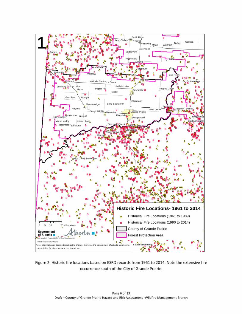
Page 6 of 13 Draft – County of Grande Prairie Hazard and Risk Assessment -Wildfire Management Branch
Figure 2. Historic fire locations based on ESRD records from 1961 to 2014. Note the extensive fire
occurrence south of the City of Grande Prairie.
"
"
"
"
$
$
"
"""
"
"
"
"
""
""
""
"
"
"
"
"
"
""
"
"
" ""
"
"
""
"
!
!
!
!!
!
!
!
!
!
!
!
!
!
!
!
!
!
!
"/
"/
"/
"/ _̂
!.
!.
BB
BB
BB
BB
BB
BBBB
BB
BB
BB
BB
BB
BB
BB
BB
BB
BB
BB
BB
BB
BB
BBBB
BB
BB
BB
BB
BB
BB
BB
BB
BB
BB
BB
BB
BBBB
BB
BB
BB
BB
BB
BB
BB
BB
BB
BB
BB
BB
BB
BB
BBBB
BB
BB
BB
BBBB
BB
BB
BB
BB
BB
BB
BB
BB
BB
BB
BB
BB
BBBB
BBBB
BB
BB
BB
BBBB
BB
BB
BBBB
BB
BB
BB
BB
BB
BB
BB
BB
BB
BB
BB
BB
BB
BBBB
BB
BB
BBBB
BB
BB
BB
BB
BB
BB
BB
BB
BB
BB
BB
BB
BB
BB
BB
BB
BB
BB
BB
BB
BB
BB
BB
BB
BB
BB
BB
BB
BB
BB
BB
BB
BB
BB
BB
BB
BB
BB
BB
BB
BB
BB
BB
BB
BB
BB
BB
BB
BB
BB
BB
BB
BB
BB
BB
BBBB
BB
BB
BBBB
BB
BB
BB
BB
BB
BB
BB
BB
BBBB
BB
BB
BB
BB
BB
BB
BB
BB
BB
BBBB
BB
BB
BB
BB
BB
BB
BBBB
BB
BB
BB
BBBB
BB
BB
BB
BB
BB
BBBB
BB
BB
BB
BB
BB
BB
BB
BBBB
BB
BB
BB
BB
BB
BBBB
BB
BB
BBBB
BB
BB
BB
BB
BB
BB
BB
BB
BB
BB
BB
BB
BB
BB
BB
BB
BB
BBBBBB
BB
BB
BBBBBB
BB
BB
BB
BB
BB
BB
BB
BB
BBBB
BB
BB
BB
BB
BB
BB
BB
BB
BB
BB
BB
BB
BB
BB
BB
BBBB
BB
BB
BB
BB
BB
BBBB
BB
BB
BB
BB
BB
BB
BB
BB
BB
BB
BB
BB
BB
BB
BB
BB
BB
BB
BB
BBBB
BB
BB
BB
BB
BB
BB
BB
BB
BB
BB BB
BB
BB
BB
BB
BB
BB
BBBB
BB
BB
BB
BB
BBBB
BB
BB
BB
BBBB
BB
BB
BB
BB
BB
BB
BB
BB
BB
BB
BB
BB
BB
BBBB
BB
BB
BBBBBB
BB
BB
BB
BB
BB
BB
BB
BB
BB
BBBB
BB
BBBBBB
BB
BB
BB
BB
BB
BB
BB
BB
BB
BB
BB
BB
BBBB
BB
BB
BB
BB
BB
BB
BB
BB
BB
BB
BB
BB
BB
BB
BB
BB
BB
BB
BB
BB
BB
BBBB
BB
BB
BB
BB
BB
BB
BB
BB
BB
BB
BB
BB
BB
BB
BB
BB
BB
BB
BB
BB
BB
BB
BB
BBBB
BB
BB
BB
BB
BB
BB
BB
BB
BB
BB BB
BB
BB
BBBBBB
BB
BB
BB
BB
BB
BB
BB
BB
BB
BB
BB
BB
BB
BBBB
BB
BB
BB
BB
BB
BB
BB
BB
BB
BB
BB BB
BB
BB
BB
BB
BB
BB
BB
BB
BB
BB
BBBBBB
BB
BBBB
BB
BB
BB
BB
BB
BB
BB
BB
BB
BB
BB
BB
BB
BB BB
BB
BB
BBBB
BB
BB
BB
BB
BB
BB
BB
BB
BB
BB
BB
BB
BB
BB
BB
BB
BB
BB
BB
BB
BB
BB
BB
BB
BB
BB
BB
BB
BBBB
BB
BB
BB
BBBB
BB
BB
BB
BB
BB
BB
BB
BB
BB
BB
BB
BB
BB
BB
BB
BB
BB
BB
BB
BB
BB
BB
BB
BB
BB
BB
BB
BB
BB
BB
BB
BB
BB
BB
BB
BB
BB
BB
BB
BB
BB
BB
BB
BB
BB
BB
BB
BB
BB
BB
BB
BB
BB
BB
BB
BB
BB
BB
BB
BB
BB
BB
BB
BB
BB
BB
BBBBBB
BBBB
BB
BB
BB
BB
BBBB
BB
BBBB
BB
BB
BB
BB
BB
BB
BB
BB
BBBB
BB
BB
BBBB
BBBB
BBBB
BB
BB
BB
BB
BB
BB
BB
BBBB
BB
BB
BB
BB
BB
BB
BBBB
BB
BB
BBBB
BB
BB
BB
BB
BB
BB
BB
BB
BB
BB
BB
BB
BB
BB
BB
BB
BB
BB
BB
BB
BB
BB
BB
BB
BB
BB
BB
BB
BB
BB
BBBB
BBBB
BB
BBBB
BB
BB
BB
BB
BB
BB
BB
BB
BB
BB
BB
BB
BB
BB
BB
BB
BB
BB
BB
BB
BB
BB
BB
BB
BB
BB
BB
BB
BB
BB
BB
BB
BB
BB
BB
BB
BB
BB
BB
BB
BBBB
BB
BB
BB
BB
BB
BB
BB
BB
BB
BB
BB
BB BB
BB
BB
BB
BB
BB
BB
BB
BBBB
BB
BB
BB
BB
BB
BB
BB
BB
BB
BB
BB
BB
BB
BB
BB
BB
BB
BB
BB
BB
BB
BB
BB
BB BB
BB
BB
BB
BB
BB
BB
BB
BB
BB
BB
BB
BB
BB
BB
BB
BB
BB
BB
BB
BB
BB
BB
BB
BB
BB
BB
BB
BB
BB
BB
BB
BB
BB
BB
BB
BB
BB
BB
BB
BB
BB
BB
BB BB
BB
BB
BB
BB
BB
BB
BB
BB
BB
BB
BB
BBBB
BB
BB
BB
BB
BBBBBBBBBBBB
BBBB
BB
BB
BB
BB
BB
BB
BB
BB
BB
BB
BB
BB
BB
BB
BB
BB
BB
BB
BB
BB
BB
BB
BB
BBBB
BB
BB
BB
BB
BB
BB
BB
BB
BB
BB
BB
BB
BB
BB
BB
BB
BB
BB
BBBB
BB
BB
BB
BB
BB
BB
BB
BB
BB
BB
BB
BB
BB
BB
BB
BB
BB
BB
BB
BB
BB
BBBB
BB
BB
BB
BB
BB
BB
BB
BB
BB
BB
BB
BB
BB
BB
BB
BB
BB
BB
BB
BB
BB
BB
BB
BB
BB
BB
BB
BB
BB
BB
BB
BB
BB
BB
BB
BB
BB
BB
BB
BB
BBBB
BB
BB
BB
BB
BBBB
BB
BB
BB
BB
BB
BB
BBBB
BB
BB
BB
BB
BB
BB
BB BB
BB
BB
BBBB
BB
BB
BB
BB
BB
BB
BB
BB
BB
BB
BB
BB
BB
BB BB
BB
BB
BB
BB
BB
BB
BB
BB
BB
BB
BB
BBBB
BB
BB
BB
BB BB
BB
BB
BB
BB
BB
BB
BBBB
BB
BB
BB
BB
BB
BB
BBBB
BB
BB
BB
BB
BBBB
BB
BB
BB
BB
BB
BB
BB
BB
BB
BBBB
BBBBBBBBBB
BB
BB
BB
BB
BB
BB
BB
BB
BB
BB
BB
BB
BB
BB
BB
BB
BB
BB
BB
BB
BBBB
BB
BB
BB
BB
BB
BB
BB
BB
BB
BB
BB
BB
BB
BB
BB
BB
BB
BBBB
BB
BB
BB
BBBB
BB
BB
BB BB
BB
BBBB
BB
BB
BB
BB
BB
BBBBBB
BBBBBBBBBBBB
BB
BB
BB
BB
BB
BB
BB
BB
BB
BB
BB
BB
BB
BB
BB
BB
BB
BB
BB
BB
BB
BB
BB
BB
BB
BB
BB
BB
BB
BB
BB
BB
BB
BB
BB
BB
BB
BB
BB
BB
BB
BB
BB
BB
BB
BB
BB
BB
BBBB
BB
BB
BB
BB
BB
BB
BB
BBBB
BB
BB
BB
BB
BBBB
BB
BB
BBBB
BB
BB
BB
BB
BB
BB
BB
BB
BB
BB
BB
BBBB
BB
BB
BB
BB
BB
BB
BB
BB
BB
BBBB
BB
BB
BB
BB
BBBB
BB
BB
BB
BB
BB
BB
BB
BB
BB
BB
BB
BB
BB
BB
BB
BB
BB
BB
BB
BBBB
BB
BB
BB
BB
BB
BB
BB
BB
BBBB
BB
BB
BB
BB
BB
BB
BB
BB
BB
BB
BB
BB
BB
BBBBBB
BB
BB
BB
BB
BB
BB
BB
BB
BB
BB
BB
BB
BB
BB
BB
BB
BB
BB
BB
BB
BB
BB
BB
BBBB
BB
BB
BB
BB
BB
BB
BB
BB
BB
BB
BB
BB
BB
BB
BB
BB
BB
BB
BB
BB
BB
BB
BB
BB
BB
BB
BB
BB
BB
BB
BB
BB
BB
BB
BBBB
BB
BB
BB
BB
BB
BB
BB
BB
BB
BB
BB
BB
BB
BB
BB
BB
BB
BB
BB
BB
BB
BB
BB
BB
BB
BB
BB
BB BB
BB
BB
BB
BB
BB
BB
BB
BB
BB
BB
BB
BB
BB
BB BB
BB
BB
BB
BB
BB
BB
BB
BB
BB
BB
BB
BB
BB
BB
BB
BB
BB
BB
BB
BB
BB
BB
BB
BB
BB
BB
BB
BBBB
BB
BB
BB
BB
BB
BB
BB
BB
BB
BB
BBBB
BB
BB
BB
BBBBBB
BB
BBBB
BB
BB
BB
BB
BB
BB
BB
BB
BB
BB
BB
BB
BB
BB
BB
BB
BB
BB
BBBBBB
BB
BB
BB
BB
BB
BBBBBB
BB
BB
BB
BB
BB
BB
BB
BB
BB
BB
BB
BB
BB
BB
BB
BB
BB
BB
BB
BB
BB
BB
BB
BB
BB
BB
BB
BB
BB
BB BB
BB
BB
BB
BB
BB
BB
BB
BB
BB
BBBB
BB
BB
BB
BB
BB
BB
BB
BB
BB
BB
BB
BB
BB
BB
BBBB
BB
BB
BB
BB
BB
BB
BB
BB
BB
BB
BB
BB
BB
BB
BB
BB
BB
BB
BB
BB
BB
BB
BB
BB
BB
BB
BB
BB
BB
BB
BB
BB
BB
BB
BB
BB
BB
BB
BB
BB
BB
BB
BBBB
BB
BB
BB
BB
BB
BB
BB
BB
BB
BB
BBBBBB
BB
BB
BBBB
BB
BB
BB
BB
BB
BB
BB
BB
BB
BB
BB
BB
BB
BB
BB
BB
BB
BB
BB
BB
BB
BB
BB
BB
BB BB
BB
BB
BB
BB
BB BB
BB
BB
BB
BB
BB
BB
BB
BB
BB
BB
BB
BB
BB
BB
BB
BB
BB
BB
BB
BB
BB
BB
BB
BB
BB
BB
BB
BB
BB
BB
BB
BB
BBBB
BB
BB
BB
BB
BB
BB
BB
BB
BB
BB
BB
BB
BB
BB
BB
BB
BB
BB
BB
BB
BB
BB
BB
BB
BBBB
BB
BB
BBBB
BB
BB
BB
BB
BB
BB
BB
BB
BB
BB
BB
BB
BB
BB
BB
BB
BB
BB
BB
BB
BB
BB
BB
BB
BB
BB
BB
BB
BB
BB
BB
BB
BB
BBBB
BB
BB
BB
BB
BB
BB
BBBB
BB
BB
BB
BB
BB
BB
BB
BB
BB
BB
BB
BB
BBBB
BB
BBBB
BBBB
BB
BB
BB
BB
BB
BB
BB
BB
BB
BB
BB
BB
BB
BB
BB
BB
BB
BB
BB
BB
BB
BB
BB
BB
BB
BB
BB
BB BB
BB
BB
BB
BB
BB
BB
BB
BB
BB
BB
BB
BB
BB
BB
BB
BBBB
BB
BB
BB
BB
BB
BB
BB
BB
BB
BB
BB
BB
BB
BB
BB
BB
BB
BB
BB
BB
BB
BB
BBBB
BB
BB
BB
BB
BB
BB
BB
BB
BBBB
BB
BB
BB
BB
BB
BB
BB
BB
BB
BB
BB
BB
BA
BA
BA
BA
BA
BABA
BA
BA
BA
BA
BA
BA
BA
BA
BA
BA
BA
BA
BA
BABA
BA
BA
BA
BA
BA BA
BABA
BA
BA
BA
BA
BA
BA
BA
BA
BA
BABA
BA
BA
BA
BA
BABA
BA
BA
BA
BA
BA
BA
BA
BA
BA
BA
BA
BA
BA
BA
BA
BA
BA
BA
BA
BA
BA
BA
BA
BABA
BA
BA
BA
BA
BA
BA
BA
BA
BABABABA BABA
BA
BA
BABA
BA
BA
BA
BA
BA
BA
BA
BA
BABA
BABA BA
BA
BA
BA
BA
BA
BA
BA
BA
BABA
BA
BA
BA
BA
BA
BA
BABA
BABA
BA
BA
BA
BA
BABA BA
BA
BA
BABA
BA
BA
BA
BA
BA
BABA
BA
BA
BA
BA
BA
BA
BA
BA
BA
BA
BA
BABA
BA
BA
BABA
BA
BA
BA
BA
BA
BA
BA
BA
BA BA
BA
BA
BA
BA
BA
BA
BA
BABA
BA
BA
BA
BA
BA
BA
BA
BA
BA
BA
BA
BA
BA
BA
BA
BA
BA
BA
BA
BA
BA
BA
BA
BA
BA
BA
BA
BA
BA
BA
BA
BA
BA
BA
BA
BABA
BA
BA
BA
BA
BA
BABA
BA
BA
BA
BA
BABA
BA
BA
BA
BA
BA
BA
BA
BA
BA
BA
BA
BA
BA
BA
BA
BA
BA
BA
BA
BA
BA
BA
BA
BA
BA
BA
BA
BA
BA
BA
BA BA
BA
BA
BA
BA
BA
BA
BA
BA
BA
BABA
BA
BA
BA
BA
BA
BA BABA BA
BA
BA
BA
BA
BA
BABA
BA
BABA
BA
BA
BA
BA
BA
BA
BA
BABA
BABA
BA
BA
BA
BA
BA
BA
BA
BABA
BA
BA
BA
BA
BA
BA
BA
BA
BA
BA
BA
BA
BA
BABA
BA
BA
BA
BA
BABA
BA
BA
BA
BA
BA
BA
BA
BA
BA
BA
BA
BA
BA
BA
BA
BA
BA
BA
BA
BA
BA
BA
BA
BA
BA
BA
BA
BA
BA
BA
BA
BA
BA
BA
BA
BA BA
BA
BA
BA
BA
BABA
BA
BA
BA
BA
BA
BA
BA
BA
BA
BA
BA
BA
BA
BA
BABA
BA
BA
BA
BA
BA
BABA
BABA
BA
BA
BA
BA
BA
BA
BABABABA
BA
BA
BA
BA
BABA
BABABA
BA
BA
BA
BA
BA
BA
BA
BABA
BA
BA
BA
BA
BA BA
BA
BA
BA
BA
BA
BA
BA
BA
BABA
BA
BABABABABABABA BA
BA
BABABA
BA
BA
BA
BA
BA
BA
BA
BA
BA
BA
BA
BA
BA
BA
BA
BABA
BA
BA
BA
BA
BA
BA
BABA
BA
BA
BA
BA
BABA
BA
BA
BA
BA
BABA
BA
BA
BA
BA
BA
BA
BA
BA
BABABA
BA
BA
BA
BA
BA
BABA
BA
BA
BA
BA
BA
BA
BA
BA
BABA
BABA
BA
BA
BA
BABA
BABA
BABA
BA
BA
BA
BA
BA
BA
BA
BA
BA
BABA
BA
BA
BA
BA
BA
BA
BA
BA
BA
BABA
BA
BA
BA
BA
BA
BA
BA
BABA
BA
BA
BA
BA
BA
BA
BABA
BABA
BA
BA
BA
BA
BABA
BA
BA
BA
BA
BA
BABA
BA
BA
BABABA
BA
BA
BABA
BABABABABA
BA
BA
BA
BABABABA
BA
BA
BA
BA
BA
BA
BA
BA
BABABA
BA
BA
BABA
BA
BA
BA
BA
BA
BA
BA
BABA
BA
BA
BA
BA
BA
BA
BA
BA
BA
BA
BA
BA
BA
BA
BA
BA
BA
BA
BA
BA
BA
BA
BA
BA
BA
BA
BA
BA
BA
BA
BA
BA
BA
BA
BA
BABA
BA
BA
BA
BA
BABA
BA
BA
BA
BA
BA
BA
BABA
BA
BA
BA
BA
BA
BA
BA
BA
BA
BA
BA
BA
BA BA
BA
BA
BA
BA
BABA
BA
BA
BABA
BA
BA
BA
BA
BA
BA
BA
BA
BA
BA
BA
BA
BA
BA
BA
BA
BA
BA
BA
BA
BA
BA
BA
BA
BA
BA
BABA
BA
BA
BABA
BA
BA
BA
BA
BA
BA
BA
BA
BA
BABA
BA
BA
BA
BA
BA
BA
BA
BABA
BA
BABA
BA
BA
BA
BABA
BA
BA
BA
BA
BA
BA
BA
BA
BA
BA
BA
BA
BA
BA
BA
BA
BABA
BA
BA
BABA
BA
BA
BA
BA
BA
BA
BA
BA
BA
BA
BA
BA
BA
BABA
BA
BA
BA
BA
BA
BA
BA
BABA
BA
BA
BA
BA
BABA
BABA
BA
BA
BA
BA
BA
BA
BA
BA
BA
BABA
BABA
BA
BABA
BA
BA
BA
BA
BA
BABA
BA
BA
BA
BABA
BA
BA
BA
BA
BA
BA
BA BA
BA
BA
BA
BA
BA
BA
BA
BA
BA BA
BA
BA
BA
BA
BA
BA
BA
BA
BA
BA
BA
BA
BA
BA
BABA
BA
BA
BA
BA
BA
BA
BA
BA
BABA
BA
BA
BABA BA
BA
BA
BA
BA
BA
BA
BA
BA
BA
BA
BA
BA
BA
BABA
BA
BA
BA
BA
BA
BA
BA
BA
BA
BA
BA
BA
BA
BA
BA
BA
BA
BA
BA
BA
BA
BA
BA
BABA
BA
BA
BA
BA
BA
BA
BA
BABA
BA
BA
BA
BA
BA
BA
BA
BA
BA
BA
BA
BABABA
BABABA
BA
BABA
BABA
BA
BA
BA
BA
BA
BA
BA
BA
BA
BA
BA
BA
BA
BA
BA
BA
BA
BA
BA
BA
BA
BA
BA
BA
BA
BABA
BABA
BA
BA
BA
BA
BA
BA
BA
BA
BA
BA
BA
BA
BA
BA
BA
BA
BA
BA
BA
BA
BA
BA
BA
BABA
BA
BA
BA
BA
BA
BA
BA
BA
BA BA
BA
BA
BA
BA
BA
BABA
BA
BA
BABA
BA
BA
BA
BA
BA
BA BA
BA
BA
BA
BA
BA
BA
BA
BA
BA
BA
BA
BABA
BA
BA
BA
BA
BA
BA
BA
BA
BA
BA
BA
BA
BA
BA
BA
BA
BA
BA
BA
BA
BA
BA
BABA
BA
BA
BA
BA
BA
BA
BA
BA
BA
BA
BA
BA
BA
BA
BA
BA
BA
BA
BA
BA
BA
BABABA
BA
BABA
BABA
BA
BA
BA
BA
BABA
BA
BA
BABABA
BABA
BA
BA
BA
BA
BA
BA
BA
BA
BA
BA
BA
BA
BA
BA
BA
BA
BA
BA
BA
BA
BA
BA
BA
BA
BA
BA
BA
BA
BA
BA
BABA
BA
BA
BABA
BA
BA
BA
BA
BA
BA
BA
BA
BA
BA
BA
BA
BA
BA
BA
BA
BA
BA
BA
BA
BA
BA
BA
BA
BA
BA
BA
BA
BA
BA
BA
BA
BA BA
BA
BA
BA
BA
BA
BA
BA
BA
BA
BA
BA BA
BA
BA
BA
BA
BA
BA
BA
BA
BA
BA
BA
BA
BA
BA
BA
BA
BA
BA
BA
BA
BA
BA
BA
BA
BA
BA
BA
BA
BA
BA
BA
BA
BABA
BA
BA
BA
BA
BA
Niobe
Manir
Gundy
Wapiti
BelloyCodesa
Goodwin
Lymburn
Webster
Halcourt
Hayfield
Albright
Brainard
Valhalla
Braeburn
Hazelmere
Leighmore
Bad Heart
Homestead
Northmark
Rio Grande
Bridgeview
Silverwood
Prestville
Puskwaskau
Horse Lake
Glen Leslie
Poplar Hill
Aspen Grove
Hinton TrailMount Valley
Buffalo Lake
Happy Valley
Lake Saskatoon
Pipestone Creek
Clarkson Valley
Nose Creek Settlement
Wanyandie Flats East Settlement
Hythe
Rycroft
Wembley
Sexsmith
Beaverlodge
Spirit River
Grande Prairie
Peoria
DeBolt
Woking
Wanham
Huallen
Demmitt
Elmworth
Dimsdale
Goodfare
Bezanson
La Glace
Wedgewood
Grovedale
Clairmont
Ridgevalley
Teepee Creek
Landry Heights
Valhalla Centre
¹
0 10 205 Kilometres
Historic Fire Locations- 1961 to 2014
BA Historical Fire Locations (1961 to 1989)
BB Historical Fire Locations (1990 to 2014)
County of Grande Prairie
Forest Protection Area
Note: Information as depicted is subject to change; therefore the Government of Alberta assumes no
responsibility for discrepancy at the time of use.
Base Map Data Provided by Spatial Data Warehouse Ltd.
©2015 Government of Alberta

Page 7 of 13 Draft – County of Grande Prairie Hazard and Risk Assessment -Wildfire Management Branch
Figure 3. Fire Behaviour Prediction System (FBP) Fuel Types.

Page 8 of 13 Draft – County of Grande Prairie Hazard and Risk Assessment -Wildfire Management Branch
Figure 4. Head Fire Intensity.

Page 9 of 13 Draft – County of Grande Prairie Hazard and Risk Assessment -Wildfire Management Branch
Figure 5. Rate of Spread.
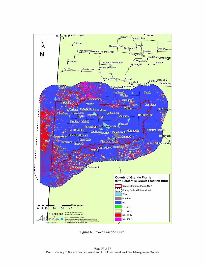
Page 10 of 13 Draft – County of Grande Prairie Hazard and Risk Assessment -Wildfire Management Branch
Figure 6. Crown Fraction Burn.

Page 11 of 13 Draft – County of Grande Prairie Hazard and Risk Assessment -Wildfire Management Branch
Figure 7. Fire Behaviour Potential.
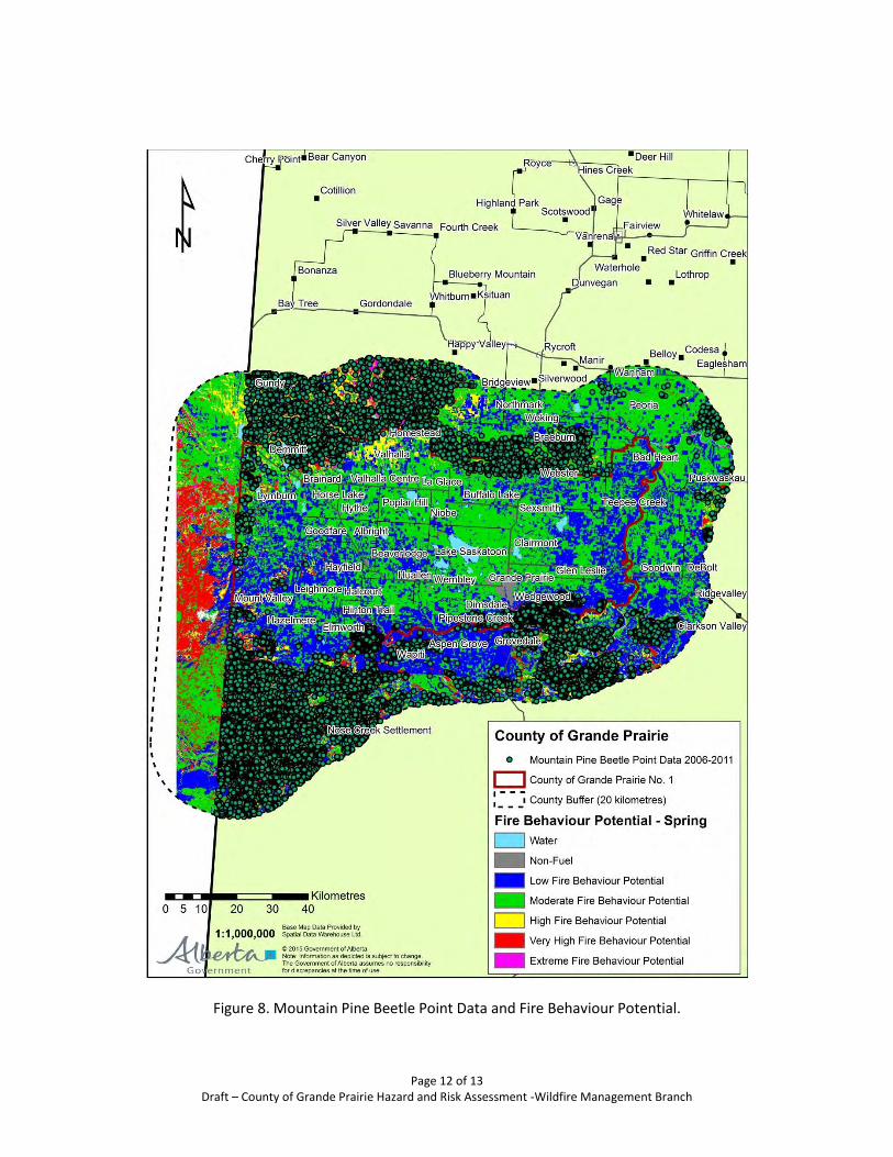
Page 12 of 13 Draft – County of Grande Prairie Hazard and Risk Assessment -Wildfire Management Branch
Figure 8. Mountain Pine Beetle Point Data and Fire Behaviour Potential.

Page 13 of 13 Draft – County of Grande Prairie Hazard and Risk Assessment -Wildfire Management Branch
Appendix A
Wildfire Threat – Fire Behaviour Potential Ratings for the Different Seasons
The spring season had the greatest Fire
Behaviour Potential and was used for the
Hazard and Risk Assessment portion of
the County of Grande Prairie Wildfire
Mitigation Strategy. The county had the
greatest amount of moderate to high fire
behaviour potential in the spring. The Fire
Behaviour Potential ranking takes into
consideration weather (as an influence on
HFI and fuel condition), HFI, CFB and FBP
fuels.

Media Advisory – For Immediate Release Monday, January 30, 2012 County of Grande Prairie FireSmart Media Tour When: Thursday, February 2, 2012 1:00 pm to approximately 2:30 pm Where: Evergreen Park TEC Centre (indoor component approx. 30 minutes)
County Fire Smart sites in Dunes (outdoor component) Who: Everett Cook, County of Grande Prairie Fire Chief
Mark Whelpton, County of Grande Prairie Fire Marshal County of Grande Prairie Council Members Jerry Bauer, Project Consultant Mort Timanson, Project Consultant Geoff Atkinson, Area Forester, Alberta Sustainable Resource Development
Why: The Dunes area in the Southeast portion of the County of Grande Prairie has been
severely affected by pine beetle. To control the beetle and and reduce the risk of fire, the County has taken a proactive approach through its “FireSmart” program in partnership with Alberta Sustainable Resource Development and the private sector. This media event will provide information about the work being done in our area through the FireSmart program. Media will also have an opportunity to go on-site and see this emergency planning tool first-hand.
Please dress in warm clothing with a comfortable pair of walking shoes/boots.
RSVP by noon on Wednesday, February 1 to: Sandra Shepherd County of Grande Prairie E: [email protected] P: 780-512-9722 X208
-30-

NEWS RELEASE – For Immediate Release February 2, 2012 FireSmart Program Aims to Reduce Risk of Wildfires At a media tour held today, local media had an opportunity to view first-hand the work underway in the Dunes through the FireSmart program. The program – a partnership between the County of Grande Prairie and Alberta Sustainable Resource Development – aims to control the pine beetle and protect residential and commercial areas from the risk of wildfires. In operation since 2010, the local FireSmart initiative has targeted the beetle infested Dunes area in the Southwest portion of the County. Infected pine trees are harvested as when they die, they create a situation where fire can spread very rapidly. “The Dunes area has been severely affected by pine beetle, creating an environment that heightens the risk of wildfire,” said Mark Whelpton, Fire Marshal with the County of Grande Prairie. “FireSmart is a proactive emergency planning tool that reduces the risk of fire and helps keep our residents safe, particularly in those areas where community meets forest.” In addition, by the end of the 2011-2012 season, the first fire break will be completed, running from the Aspen Ridge Subdivision to Evergreen Park. A fire break is a strip of cleared land, making it easier to slow the progress of fire. Extra “clean-up” will be conducted to ensure the fire hazard is reduced even more than normal logging operations. Heavier debris such as tops of trees are piled and burned. Lighter debris is spread throughout the logged area, not only reducing the fire risk, but promoting the natural regeneration of pine trees. Whelpton said that County taxes are not impacted by program expenses. Eighty percent of the costs are funded through the sale of the harvested timber to forest companies. The remaining 20 percent is covered by grants. Late last year, Alberta Sustainable Resource Development (ASRD) awarded the County of Grande Prairie a grant of $442,460 for its 2011/2012 FireStart program.

FireSmart/2
Said Whelpton: “Public safety is our priority. This funding plays an important role in ensuring we can take a preventative approach to minimizing risks of wildfire within higher-risk areas in the County.” The County received an earlier grant from ASRD of $359,000 for the 2010/2011 period. The 2011-2012 program will be complete by March 31, with an estimated 275 hectares logged over the past two years. Two additional years are required to complete the project, and are contingent on funding being secured. A public education component of the FireSmart program will be announced this spring.
-30- For more information contact: Mark Whelpton Fire Marshal Phone: 780-532-9722

NEWS RELEASE – For Immediate Release Monday, May 7, 2012 County Hosts FireSmart Education Day & Trade Fair A County of Grande Prairie FireSmart Education Day & Trade Fair is aimed at home and business owners to arm them with information on how to protect their properties from wildfire. The free event will be held this Saturday, May 12 starting at 8:30 am at Clarkson Hall, Evergreen Park, with activities running until 3:30 pm. The day will include workshops, fire department demonstrations, a trade fair featuring products that will help reduce risk of damage or fire, and a lunch bar-b-que. “As we build our communities closer to the forest edge, wildfire becomes a very real threat,” said County of Grande Prairie Fire Marshal Mark Whelpton. “FireSmart Education Day is about taking a proactive, preventative approach and giving people the tools to keep their properties and their families safer.” Whelpton said residents will come away with plenty of easy-to-implement ideas. Information will include understanding the risk of wildfire in our area, how to conduct a property risk assessment, what building or landscaping products will reduce the risk, and how to make our neighbourhoods firesmart. While those living near treed areas are at an increased risk, Whelpton said that residents with homes or property surrounded by grassy areas may also be at increased risk and will find the information valuable. There is no charge for the event and no registration is required. The public invited to attend all day, though drop-ins are also welcome. The FireSmart Education Day & Trade Fair is a collaboration of the County of Grande Prairie and Alberta Sustainable Resource & Development, and marks the beginning of a FireSmart public education campaign in the County. Also part of the FireSmart initiative, over the past year several mountain pine beetle trees were cleared in the area from Aspen Ridge Subdivision to Evergreen Park, creating a fire break to stop or slow the progress of fire. -30-

For more information contact: Mark Whelpton Fire Marshal County of Grande Prairie Phone: 780-532-9727

WILDFIREis a threat to
residents living near the forest edge
You are not helpless against the threat of wildfire.
Simple practices can help create a safe, FireSmart community.
Learn how to make your property FireSmart.
FREE EVENT!

FireSmart County of Grande Prairie
Education Day & Trade FairEducation Day & Trade Fair
If so, wildfire is a real threat. Learn how to protect your property.
Evergreen Park (Clarkson Hall)South of GP on Resources Road. Left on RR6688:30 am – 12:30 pmInfo sessions12:30 pm
Bar-b-que & Trade Fair1:30 pm – 3:30 pm County Fire Department Demonstrations
Is your home or business near treed or grassy areas?
Saturday,May 12, 2012
No Cost.No registration.
For more info: 780.532.9727 or countygp.ab.ca
Join us all day or part of the day!

-continued-
News Release – For Immediate Release –Thursday, September 12, 2013 County FireSmart Wood Waste Clean-up set for next two Saturday’s County residents and businesses are encouraged to bring wood debris, branches and deadfall from their yard to the County FireSmart Wood Waste Clean-up events. “Wildfires pose a great threat to properties that are situated in treed and grassy areas,” says Ken Atamanchuk, County Fire Marshall. “The FireSmart Wood Waste Clean-up gives residents the opportunity to learn about the FireSmart program and protect themselves and property from wildfires by dropping off their wood debris, branch and deadfall from their yard. The County FireSmart Wood Waste Clean-up will take place at the following times and locations:
• Saturday, September 14 from 9 a.m. to 5 p.m. in Deer Run Estates (located off Township Road 710 and Range Road 64)
• Saturday, September 21 from 9 a.m. to 5 p.m. in Taylor Estates (located off Township Road 712 and Range Road 55. Turn left at Willow Grove Way)
Chippers courtesy of Vermeer Canada and TC Equipment will be on site for wood waste to be properly broken down and disposed of by the County Fire Service free of cost. Alberta Environment and Sustainable Resource Development staff will also be on site handing out information and answering questions regarding the FireSmart program. For more information, please visit www.countygp.ab.ca or contact Ken Atamanchuk, County Fire Marshall at 780-532-9727.
-30-
Media contact: Ken Atamanchuk County Fire Marshall 780-532-9727