Embed Size (px)
Citation preview

White River Field Office Oil & Gas Development Proposed RMPA/Final EIS
Northwest Resource Advisory Council June 4, 2015

Briefing Objectives
Planning Process & Schedule
Proposed Amendment (Alternative E)

Schedule
Published Notice of Availability in Federal Register on 3/27
• 30-day Protest Period ended 4/27
• 60-day Governors Consistency Review ended 5/26
WO Reviews and Resolves Protests
• In progress
Record of Decision and Approved RMP Amendment
• July 2015

Planning Area: 2.7 million ac
BLM Surface: 1.5 million ac
Federal Mineral Estate: 2.2 million ac
61% of BLM leasable acres already leased
(80% of leasable acres within the MPA)
(26% of leasable acres within the MLP)

Need for the Amendment
• Changing conditions since the 1997 RMP…
Level of development
(from 1,100 to 15,040 wells)
Type of development
(from single to multi-well pads)
Location of development
(from south of Rangely to Mesaverde Play Area)
• Proposed RMPA (Alternative E) assumed…
Development of 15,040 wells on 1,100 multi-well pads with
an associated surface disturbance of 13,200 acres
Majority of development will occur within the Mesaverde Play
Area (MPA)
5

How does the Oil & Gas RMPA change the 1997 RMP?
Major decisions in the RMPA include:
• Using thresholds to promote clustered development in order to allow for
year-round drilling while reducing habitat loss due to behavioral
avoidance by big game (especially mule deer);
• Identification of specific success criteria for reclamation;
• Using a tiered approach to managing lands with wilderness
characteristics;
• Adoption of the Dinosaur Trail Master Leasing Plan (MLP).
The RMPA does not change any decisions related to:
• Non-oil and gas related activities or programs;
• Special designations; or
• Areas open or closed for oil and gas leasing.
6

7
Lease Stipulations
Timing Limitations: 1,696,000 acres
Controlled Surface Use: 514,400 acres
No Surface Occupancy: 405,600 acres
Closed to Leasing: 83,300 acres

Potential Non-Recoverable Oil & Gas Resource
Assumed current technology could drain resources
from 2,900 ft from the edge of effective NSO areas.
2% of the 1.7 million acres
available for oil & gas
leasing by the BLM would be
non-recoverable
• Less than 7.5 acres within
an NSO area
• Aggregate of small NSOs
within 600 ft of a larger NSO
• NSOs with less than 600 ft
between boundaries
Approximately 34,700 acres would be
non-recoverable using current technology
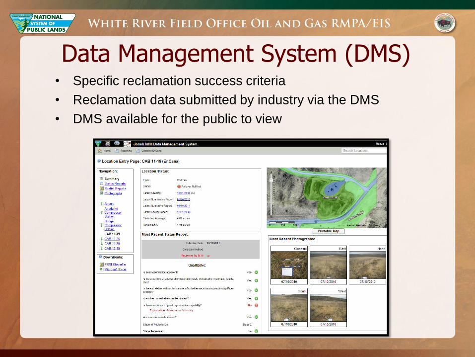
Data Management System (DMS) • Specific reclamation success criteria
• Reclamation data submitted by industry via the DMS
• DMS available for the public to view

Threshold Concept
Benefits of Using Thresholds?
Supports year-round oil and gas activities
Encourages prompt reclamation
Supports clustering development
Natural Resources Law Center Natural Resources Law Center
Guntis Moritis

Threshold Concept How does it work?
All of WRFO would have TL stipulations
Mapped mule deer seasonal ranges can not overlap
(modified CPW map)
Adverse Behavioral Effects
• Acute Effects
• Collective Effects
• Buffered by 660ft
Thresholds Applied by:
• Game Management Unit
• Mule Deer Seasonal Range
• Leaseholder/Unit

Big Game Timing Limitations & Thresholds
Timing Limitations
• Up to 120 days: severe winter range (Dec 1 – Apr 30)
• Up to 90 days: summer range (May 15 – Aug 15)
• Up to 60 days: winter range & winter conc. areas (Dec 1 – Apr 30)
Acute Thresholds
• 20% of deer winter range and winter concentration areas
• 15% of severe winter range and summer range
• 0% of Restricted Development Areas (North Ridge)
Collective Thresholds
• 20% of all seasonal ranges
• 5% of Restricted Development Areas (North Ridge)

Thresholds applied
by:
1) leaseholder
2) GMU
3) seasonal range
Threshold Concept Diagram

Implementation of the Threshold Concept
• Use the DMS to track disturbance, reclamation, and activity.
• Grace period of 5 years after the ROD to allow compliance for
those leaseholders exceeding threshold allowances at the time
the ROD is issued.
• Intend for thresholds to be refined when necessary and through
appropriate means based on animal response or the influence
of compensatory mitigation in meeting long-term population
objectives.

What are lands with wilderness characteristics?
• Lands with wilderness characteristics are a resource and not a special
designation
• They are a resource to be managed in a defined area
Similar to visual resources…
• VRI is what the resource is on the ground
• VRM is BLM’s decision on how to manage that resource
Not designated, but evaluated, considered, and managed

Inventory Guidance (Manual 6310)
• Undeveloped ROWs and mineral leases are not treated as
impacts to wilderness characteristics because these rights may
never be developed
• An area can have wilderness characteristics even though every
acre within the area may not meet all the criteria. The boundary
should be determined largely on the basis of wilderness
inventory roads and naturalness…
Inventory guidance results in
lands with wilderness characteristics
polygons that include existing leases

Planning Guidance (Manual 6320)
Manageability
• Consider whether the lands can be effectively managed to protect their
wilderness characteristics
• Determine how areas will be managed based on knowledge of resources,
ongoing uses, and valid existing rights in the area
Resource Values & Uses
• Consider the extent to which other resource values and uses of LWCs would be
forgone or adversely affected if wilderness characteristics are protected
• Consider the benefits that may accrue to other resource values and uses as a
result of protecting wilderness characteristics
• Specifically consider the following: presence of other resources, development
potential, resource availability (present on lands outside of LWCs), economic
importance (develop or protect), and compatibility with protection (compatible or
conflicts with wilderness characteristics)

Manageability of Lands with Wilderness Characteristics
• Manage by levels in consideration of existing rights.
• Tier 1: Parcels with ≥ 5,000 acres that are not leased or
encumbered by ROWs
• Tier 2: If current leases were to expire, then ≥ 5,000 acres would
not be encumbered
Assume development in MPA
Manage for some wilderness characteristics values in MLP
• Tier 3: Less than 5,000 acres within the parcel that aren’t
currently held by production

Tiered Management Approach for Lands with Wilderness Characteristics
• Tier 1: managed to protect wilderness characteristics as a
priority over other multiple uses
NSO with no exceptions; ROW exclusion areas
No construction of facilities or new roads
• Tier 2: managed to emphasize other multiple uses while
applying management restrictions to reduce impacts to
wilderness characteristics
ROW avoidance area
CSU stipulation (linear features can’t bisect the unit; new
development located adjacent to existing roads)
• Tier 3: managed to emphasize other multiple uses as a priority
over protecting wilderness characteristics

20
Lands with wilderness
characteristics
70,000 acres
67,900 acres
164,000 acres

Master Leasing Plan
What is an MLP?
• Concept introduced in leasing reform IM-2010-117
• Not a special designation but rather a planning area boundary
• More focused analysis of decisions pertaining to oil and gas compared to a typical
RMP revision but not as detailed as a master development plan
Criteria
1. Substantial portion of MLP is not leased
2. There is a majority Federal mineral interest
3. Industry has expressed interest in leasing & there is a moderate or high potential for
oil and gas confirmed by the discovery of oil and gas in the general area.
4. Additional analysis or information is needed to address likely resource or cumulative
impacts if development were to occur where there are multiple use or natural/cultural
resource conflicts; impacts to air quality; impacts on resources or values of any unit
of the National Park System; or impacts on other specially designated areas.

Dinosaur Trail MLP
Dinosaur Trail MLP
• Borders Dinosaur National Monument
• Contains 3 WSAs and 4 ACECs
• 422,700 acres within the MLP
• 315,600 acres open to leasing
• 42,200 acres closed to leasing
All decisions in the RMPA apply to the MLP
Additional key decisions that apply only within the MLP
• Phased leasing
• Master Development Plans required
• CSU for visual resources, night skies, and soundscapes

Dinosaur Lowlands vs Dinosaur Trail

Phased Leasing in the MLP
Leasing would first occur in the southern portion of the MLP, where the oil
and gas occurrence potential is rated medium or high.
Leasing within sage-grouse habitat, areas of low oil and gas potential, or
areas adjacent to Dinosaur National Monument would occur once the BLM
has completed additional analysis and planning.
Within sage-grouse habitat in the MLP, leasing would only occur after the BLM
has issued the Record of Decision for the Northwest Colorado Greater Sage-
Grouse RMPA.
Outside of sage-grouse habitat, areas within either low oil and gas potential or
adjacent to Dinosaur National Monument Headquarters could be leased only
after the RMP Revision to determine whether or not leasing is appropriate given
considerations such as the potential impacts to visual resources, night skies, and
soundscapes.
24

25
Mineral Estate and Phased Leasing in the Dinosaur Trail MLP
Harpers Corner
Road
Headquarters/
Visitor Center

Visual Resources, Soundscapes, and Night Skies in the MLP
CSU-37:
• Applies to all federal mineral estate within the MLP that is identified as,
adjacent to, or surrounded by VRM Class II areas
• Requires a site-specific Visual Resources Management and Noise
Reduction Plan prior to initiating construction activities.
retain the existing character of the landscape to meet VRM Class II
minimize noise using the best available technology
minimize impacts to night skies (specific lighting designs & timing of operations)
must coordinate with NPS for development north of Highway 40
CSU-36:
• Applies to VRM Class III areas adjacent to Dinosaur NM Headquarters
• Similar to original NPS request and requires operators to minimize light and
noise pollution.
26

CSU-36 and CSU-37
27
Harpers Corner
Road
Headquarters/
Visitor Center
CSU-36 CSU-36

Questions?