Embed Size (px)
Citation preview

Pito
u van D
ijck (eD.)
28
Pitou van Dijck (ed.)
What is the Future for Amazonia?Socio-Economic and Environmental Transformation and the Role ofRoad Infrastructure
What is the Future for A
mazonia?
C u a d e r n o s d e l C e d l a
Cu
ad
ern
os d
el Ced
la
Amazonia is going through a large-scale and probably irreversibletransformation process. The size of territories in use for small-scale and large-scale mining, cattle raising, agricultural production and timberlogging is expanding rapidly. These activities are supported by a rapidly increasing network of roads and an expanding system of (hydro) energy supply. Flows of migrants are looking for new employment opportunitiesand income to start a new life in settlements and service centres throughout the region. Hence, amidst the largest forest on earth a new resource-based economy is being developed. As a consequence of these interrelated developments, large-scale land use change and deforestation are taking place. In view of improved accessibility of the area and growing world demand for (processed) natural resources, the anthropogenicpressure is expected to increase further in the years to come.
This Cuaderno del ceDla focuses on these recent socio-economicdevelopments in Amazonia, in particular on: the diversity amongmunicipalities, provinces and regions in socio-economic levels ofdevelopment and speed of transformation; spatial and environmental modelling of potential impacts of such developments on future landuse and deforestation; and the potential contributions of strategicenvironmental assessments (SEAs) of (road) infrastructure.
The contributors are Bert van Barneveld, tropical agriculturalist and agro-ecologist, former Regional Manager of DHV, La Paz, Bolivia; Ruud Buitelaar, economist at ILPES/ECLAC, Santiago de Chile; Martin van der Beek, economist at Object Vision, Amsterdam; Pitou van Dijck, economist at ceDla, Amsterdam; Sergio González Catalán, agronomist at ILPES/ECLAC, Santiago de Chile; Ronnie Lassche, earth scientist at Object Vision, Amsterdam; Mathilde Molendijk, GIS specialist at VUUniversity Amsterdam; Luis Riffo Pérez, economist at ILPES/ECLAC;Rob Vos, economist at the FAO, Rome; Marinella Wallis, International Policy Studies, formerly of ceDla.
ceDla conducts social science and history research, offers a master’s programme on the societies and cultures of Latin America, and has a specialized library for the study of the region. The Centre also publishes monographs and a journal on Latin America.
iSBn 978-90-70280-29-1 / nuR 903
28


WHAT IS THE FUTURE FOR AMAZONIA?


WHAT IS THE FUTURE FOR AMAZONIA?
SOCIO-ECONOMIC AND ENVIRONMENTAL TRANSFORMATION AND THE ROLE OF
ROAD INFRASTRUCTURE
PITOU VAN DIJCK (ED.)

Cuadernos del CEDLA Editorial Board
Michiel Baud
Pitou van Dijck
Arij Ouweneel
Cuadernos del CEDLA, No. 28
ISBN 978-90-70280-29-1
NUR 903 Economische geografie
© 2014 CEDLA, Amsterdam
Centre for Latin American Studies and Documentation
Roetersstraat 33
1018 WB Amsterdam
The Netherlands
www.cedla.uva.nl
www.cedla.uva.nl/50_publications/cuadernos.html
Financial support from the European Union’s Seventh Framework Programme FP7-2010 (Grant Agreement No SSH-CT-2010-266710) for the ENGOV project on Environmental Governance in Latin America and the Caribbean is gratefully acknowledged.
printed by HAVEKA, de grafische partner, Alblasserdam

| V
Contents
Notes on the contributors vii List of figures, graphs, maps and tables viii Chapter 1. SOCIO-ECONOMIC AND ENVIRONMENTAL
TRANSFORMATION OF AMAZONIA: INTRODUCTION Pitou van Dijck
1
Chapter 2. SUSTAINABLE DEVELOPMENT IN THE AMAZON:
TERRITORIAL DISPARITIES AND INTEGRATION STRATEGIES Ruud Buitelaar, Sergio González Catalán and Luis Riffo Pérez
17
Chapter 3. HUMAN ACTIVITY AND THE FUTURE OF
ECUADOR’S AMAZON REGION: ECONOMIC DIVERSIFICATION, INFRASTRUCTURE AND EMPLOYMENT Rob Vos
41
Chapter 4. SPATIAL IMPLICATIONS OF NEW ROAD
INFRASTRUCTURE FOR THE USE OF LAND AND RESOURCES IN SURINAME: LAND USE SCANNER Martin van der Beek, Ronnie Lassche and Mathilde Molendijk
53
Chapter 5. TROUBLESOME ASSESSMENT: CONTROVERSIES
OVER THE MANAUS-PORTO VELHO HUB AND ITS IMPACT ASSESSMENT Marinella Wallis
73
Chapter 6. STRATEGIC IMPACT ASSESSMENTS,
STAKEHOLDERS’ PARTICIPATION AND GOVERNMENT POLICIES Bert van Barneveld
89
Chapter 7. SEAS AND THE CHALLENGE OF SUSTAINABLE
DEVELOPMENT: IMPROVING EFFECTIVENESS AND STRENGTHENING THE INTERNATIONAL LINKAGE: CONCLUSION Pitou van Dijck
105

VI |

| VII
Notes on the contributors
Bert van Barneveld is a tropical agriculturalist, agro-ecologist and natural resources specialist, former Regional Manager of the DHV Consulting Group of the Netherlands in La Paz, Bolivia. He was the coordinator of the strategic environmental assessment of the Cor-redor Norte (IIRSA) in Bolivia.
Martin van der Beek is an economist and partner of Object Vision, a small enterprise that focuses on the design, development, implemen-tation and support of software tools for spatial planning and model-ling.
Ruud Buitelaar is economist, Head Regional and Local Development at the Instituto Latinamericano y del Caribe de Planificación Econó-mica y Social (ILPES) at the Comisión Económica para América Lati-na y el Caribe (CEPAL/ECLAC), UN, Santiago de Chile.
Sergio González Catalán, agronomist with a Masters in Agrarian Economics, is researcher at ILPES at CEPAL/ECLAC, Santiago de Chile.
Pitou van Dijck is Associate Professor of Economics at CEDLA. Most of his research and publications deal with macro-economic and trade-related topics such as regional integration and multilateral trade policy (WTO). Since 2004 he has studied the impact of infrastructure in Amazonia.
Ronnie Lassche is an earth scientist working previously at the De-partment of Regional Economics at the VU University Amsterdam. Recently he joined Object Vision, Amsterdam.
Mathilde Molendijk holds a degree in cultural anthropology and GIS. She works at the VU University Amsterdam, Section Earth and Eco-nomics.
Luis Riffo Pérez, economist with a Masters in Geography of Globali-sation and Development, is researcher at ILPES at CEPAL/ECLAC, Santiago de Chile.
Rob Vos, economist, is director of the Social Protection Division at the Food and Agriculture Organization (FAO) of the UN, Rome. His current position involves him with issues related to social protection, rural employment and gender equality in relation to broader rural development and poverty reduction strategies.
Marinella Wallis holds a degree in International Policy Studies from the VU University Amsterdam and was researcher and editor at CED-
LA. She participated in the CEDLA research projects related to Ama-zonia and Suriname.
VIII |
List of figures, graphs, maps and tables
Figure 3.1 Mean rural labour incomes by geographic region, 2010 Figure 3.2 Rural labour incomes in Ecuador’s Amazon region, 2010 Figure 4.1 Conceptual scheme of the Land Use Scanner Suriname Figure 6.1 Stakeholders’ participation in the Corredor Norte SEA Graphs 2.1 – 5 Growth share matrix, five countries Map 1.1 IIRSA plans for infrastructure in Amazonia Map 1.2 PAC plans for infrastructure development in Brazilian Amazonia Map 1.3 Road construction in Brazilian Amazonia, 2004-2007 Map 1.4 The future of Amazonia? Map 2.1 First-tier subnational entities and the road network in the Amazon Map 3.1. Overlaps in territorial concessions for oil exploitation, forest
conservation and control by indigenous populations in the Amazon region.
Map 4.1 Current land use map, 2009, Suriname Map 4.2 Suriname, development of road infrastructure, 2011-2025 Map 4.3 Projected land use Suriname 2018 Map 4.4 Suriname, increased accessibility of the interior towards major
settlements 2011-2025 Map 4.5 EduGIS website, Suriname section Map 5.1 The BR-319 and adjacent territory between the rivers Purus and
Madeira Map 5.2 IIRSA hubs in the north of South America Map 5.3 Federal roads (paved, unpaved, and planned) in northern Brazil Map 5.4 Area under Provisional Administrative Limitation (ALAP) Map 5.5 Impact area of the BR-319 with a 10 km buffer zone Map 6.1 IIRSA Peru-Bolivia-Brazil hub including the Corredor Norte Map 6.2 Corredor Norte and natural regions in its impact area Table 2.1 Typology of territories in the Amazon based on productivity and
growth performance Table 2.2 National strategies for the integration of the Amazon Table 3.1 Employment structure in rural areas, in percentages, 2010. Table 3.2 Determinants of rural employment in non-agricultural activities,
2010 Annex Table 2.1 Amazon territories: basic indicators of population and GDP Annex Table 2.2 Amazon territories: basic social development indicators

1.
SOCIO-ECONOMIC AND ENVIRONMENTAL TRANSFORMATION OF AMAZONIA: INTRODUCTION
PITOU VAN DIJCK
Introduction
Amazonia has become a significant platform for the exploitation, processing and export of natural resources. Land use maps show the growing size of territories in use for mining, including small-scale gold digging, small and large-scale cattle raising and agriculture, production of hydro energy, and timber logging. These activities are supported by an inflow of foreign and domestic direct investment; flows of migrants; the construction or improvement of transport infrastructure like roads, railways, water and air transport facilities; and (hydro) energy-related infrastructure including storage lakes and high voltage transmission lines. Moreover, the spread of a network of service centres contributes to the creation of an enabling environ-ment for human settlements and economic activities. Hence, amidst the forest a new natural resource-based economy is being developed. As a consequence of these interrelated developments, the anthropo-genic pressure has been increasing significantly, be it that municipal-ities, provinces, regions and states in Amazonia differ widely in terms of socio-economic development, speed of change, mode and degree of connectivity, and anthropogenic pressures on the environ-ment. Intensification of economic development and related envi-ronmental impacts are expected to increase in view of the improved

2 | PITOU VAN DIJCK
accessibility of the area and growing world demand for natural re-sources at relatively high prices. Overviewing the available data sets on socio-economic develop-ments, environmental conditions and anthropogenic pressure it follows that regions, states, provinces and municipalities in Amazo-nia differ widely in these respects. See Van Dijck 2013 and 2014. The areas that have traditionally been most developed and deforested in Brazilian Amazonia were located at the region’s eastern, south-eastern and southern borders, where most economic activities, infra-structure and people used to be concentrated. Manaus has always been a highly peculiar economic hotspot as the largest metropolitan city in the forest. More recently new centres of gravity have emerged, changing the socio-economic landscape significantly. The study by Buitelaar in Chapter 2 of this Cuaderno shows wide diversities in levels of socio-economic development in 29 territories in five coun-tries in Amazonia and the emergence of some of them. In general, increased intensity of economic activity in Amazonia is related with intensified infrastructure, increased anthropogenic pressure and deforestation. The current emphasis on the exploitation of the direct use values of Amazonia may increasingly conflict with the potentials of the area to generate actual and future indirect use values like water regula-tion, fire prevention, carbon sequestration, and as a stock of biodiver-sity. These indirect use values generally become available to local or regional communities or even to the world as a whole as (quasi) pub-lic goods. Notwithstanding the significant size of areas that are pro-tected to different degrees to serve the livelihood of their indigenous inhabitants or to safeguard biodiversity and eco-systems, the options to protect effectively these indirect use values, existence values and optional values of the territory are being reduced by the increased ease of access to the region as a whole, its growing population and encroaching economic activities. This study focuses on the critical role of roads in the process of socio-economic and environmental transformation of Amazonia. In all countries in Amazonia road construction has become a priority at all levels of governance. Over the last two decades plans have been developed and implemented at the regional, state and provincial levels as well as the level of municipalities to expand road networks. Alternatively, private investors in mining, hydro-energy and other types of natural resource exploitation have been involved in road construct ion to support their private ventures. Moreover, govern-ments and private investors have cooperated in public-private-partnerships in road construction. With the growth of the road network, the availability of large pri-vate investment funds, and high international demand for natural resources including food and industrial inputs, roads increasingly
SOCIO-ECONOMIC AND ENVIRONMENTAL TRANSFORMATION OF AMAZONIA | 3
play a key role in supporting economic and social change and with it change in land use. Roads may have been constructed for specific objectives at a macro-economic and strategic level, as part of a devel-opment plan for sub regions and municipalities, or at the level of individual enterprises and investors. However, once constructed for whatever purpose, by far most of these roads function as public goods characterized by free access for all as exclusion of users is nearly impossible. This contributes strongly to the critical role road play as mechanisms to induce change in and beyond adjacent territo-ries, and to steer regional development and transformation. Moreo-ver, the areas adjacent to the roads in many cases are beyond effective control and consequently also show characteristics of quasi-public goods or localized club goods in some respects. Even so-called pro-tected areas are impacted by roads in their vicinity as protection and control in many cases are less than optimal. Road construction In Amazonia started in the 1960s as part of national programmes to colonize the forest and integrate Amazonia with the rest of the economies. The construction and improvement of roads has been accelerated since the 1990s and particularly since the beginning of the new millennium. The currently introduced pro-grammes aim at improving the connections between extraction areas with ports and at connecting efficiently producers like mining corpo-rations and food producing enterprises with forward and backward linked suppliers of goods and services, such as suppliers of local facilitary services and of energy. Large-scale infrastructure pro-grammes have become a priority in government policy, planning and budgeting in Latin America and the world all over International mar-ket penetration are in-time delivery are key ingredients of successful open macro-economic growth models, particularly in small coun-tries. Internationalization may imply that countries have an econom-ic interest in the quality and lay-out of infrastructure of their econom-ic partners and neighbours which in some cases may be a rationale for strategic cooperation and investment in infrastructure abroad. Not only globalization but regionalization as well impact on the priority for specific trajectories and on the lay-out of the infrastruc-ture and related economic developments. In the context of relatively open economic development models pursued in many countries in South America, the spread of intra-regional preferential trade agree-ments and bilateral investment treaties, construction of a supporting regional road infrastructure has become a priority as reflected by the programming of IIRSA and COSIPLAN/UNASUR. Interestingly, some border areas adjacent to these newly constructed or recon-structed international roads have experienced a new type of develop-ment. Special development programmes have been designed to sup-port and order the development of such border regions as is the case with Zicosur connected with the IIRSA Capricorn hub; the MAP

4 | PITOU VAN DIJCK
initiative integrating Peru’s Madre de Dios, Brazil’s Acre and Boliv-ia’s Pando regions; and PADIF, dealing with developments in in the Andean region. The next section of this chapter presents briefly some significant road programmes in South America which play a key role in the reshaping of Amazonia. The third section focuses more specifically on the local impact of roads on land use and deforestation. The fourth section clarifies the potential contribution of strategic envi-ronmental assessments (SEAs) and related plans of action to reduce negative environmental impacts of roads – like deforestation, disrup-tion and destruction of eco-systems and loss of biodiversity – and to support potential contributions to socio-economic development. The final section presents briefly the main topics dealt with in this Cuaderno del CEDLA.
Mega-road programmes
Infrastructure investment throughout South America has been sup-ported by initiatives at the local, regional and national levels and by a continental-wide programme. The Brazilian Programa de Aceleração do Crescimento (PAC) is a significant example of a nation-wide ap-proach in which infrastructure as such is considered a major driver of renewed economic growth. The Mato Grosso State Programa Es-tradeiro is a major case of an infrastructure development programme designed and developed at the state level with emphasis on public-private partnerships. See Van Dijck and Den Haak 2006. The Integra-tion of Regional Infrastructure in South America (IIRSA) is a rather unique effort to support integration among countries in the region and to support the region’s insertion in global markets and particu-larly markets in Asia. See Van Dijck 2013. Hence, these programmes aim at supporting a major spatial and functional reorientation of the economies. Moreover, in the course of time these mega roads will develop into the backbone of a newly induced pattern of side roads linking new production sites with markets and related processing facilities. The so-called fishbone pattern of roads is the physical and spatial reflection of the aim of the road programme: the creation of axes of development and integration. The IIRSA and PAC pro-grammes of mega- roads speed up land use conversion, deforestation and the construction of linked road networks in adjacent territories. Ahmed et al (2013) found that during the period 2004-2007 the road network in Amazonia increased by almost 17,000 km on an annual basis. See Maps 1.1, 1.2 and 1.3. Although some public-private partnerships have emerged, most of the road construction has been initiated and financed by national, state or local governments, in cooperation with national or interna-

SOCIO-ECONOMIC AND ENVIRONMENTAL TRANSFORMATION OF AMAZONIA | 5
tional development banks like the IDB, CAF, BNDES and others. Chile has introduced some interesting and renovating partnerships in road building. The Mato Grosso State Programa Estradeiro, initi-ated in early 2003, is another case in point. Concerning the priority for new lay-outs of multi-modal transport systems and networks, we note that in general terms the lay-out needs to match the direction of trade flows. The existing infrastruc-ture network is largely determined by historical trade and transport patterns. Rapid changes in the location of centres of economic gravity related to the emergence of national economies or regions, or to the liberalization of national or regional trade and investment regimes, have strongly stimulated the priority to redesign and to supplement the existing infrastructure lay-out. New roads connect the south with the Amazon River and the centre with the Caribbean Sea. Port im-provement in the Guyanas and along the Caribbean Sea coast im-prove connectivity with the Panama canal and in the future maybe with the Nicaragua canal. Moreover, the connections between the east and west side of the Amazon territory is being improved to facili-tate transport of (bulk) goods between Asia and South America.
IIRSA
The creation of IIRSA in 2000 initiated an ambitious, region-wide effort to bolster economic development by deepening integration and strengthening the region’s position in the globalization process. All countries in South America participated in the programme for an initial period of ten years (2000-2010). Subsequently, UNASUR has embedded the IIRSA initiative as part of its COSIPLAN, which was established in August 2009. IIRSA is organized in a series of so-called development hubs, ejes de integración y desarrollo or eixos de desenvolvimento. This concept had also been applied in the context of the Brazilian infrastructure programme PAC. The concept of development hubs is critical to the understanding of both the objective and the potential impact of IIRSA road infra-structure. As put by the Inter-American Development Bank (IDB):
[t]he concept of the hub is novel in that it attempts to fully address the economic, social and environmental dimensions of physical integration and their interplay in the project development process…. IIRSA’s com-prehensive approach to projects sets a priority on environmental protec-tion and is responsive to a growing awareness of its importance by the people of the region. Organized society and elected governments are in-creasingly attuned to this reality. The IIRSA approach of applying the concept of hubs helps address environmental issues in a structured way and offers planners and other stakeholders a vision for development op-portunities, alternatives and needs to ensure effective and balanced re-gional integration (IDB, October 2006, p. 17).

6 | PITOU VAN DIJCK
Map 1.1 IIRSA plans for infrastructure in Amazonia

SOCIO-ECONOMIC AND ENVIRONMENTAL TRANSFORMATION OF AMAZONIA | 7
Source: UNASUR COSIPLAN Integration Priority Project Agenda, November 2011, Map 5, p. 43.

8 | PITOU VAN DIJCK
Map 1.2 PAC plans for infrastructure development in Brazilian Amazonia
Source: PAC 2 | 9o Balanço 2011 > 2014.
The Initiative focuses particularly on improving the interconnections among the national road networks, improvement of strategic water-ways and railways, border-crossing facilities, ports and airports, tele-communications and energy facilities. In some respects IIRSA objec-tives, agenda and approach is comparable with the infrastructure programmes of the EU. As multi-purpose, multimodal and regional infrastructure programmes, both IIRSA and the EU programmes aim at deepening integration with neighbouring countries, at strengthening the position in the globalization process, and at devel-oping backward or lagging areas in national economies, as reflected by the concept of development hub in the IIRSA agenda. In both regions, transport, energy and telecommunications networks have been developed by national programmes, and both regions aim at connecting, integrating and harmonizing the national networks into the wider regional context. Note however that at least so far IIRSA has made only limited progress to realize its ambitions and plans (IDB 2008). Specifically, by far most of IIRSA related investments are concentrated in only two of the nine IIRSA development hubs: the Mercosur-Chile hub and the Peru-Brazil-Bolivia hub. Moreover, the ambition to stimulate

SOCIO-ECONOMIC AND ENVIRONMENTAL TRANSFORMATION OF AMAZONIA | 9
Map 1.3 Road construction in Brazilian Amazonia, 2004-2007
Source: S. Ahmed, C. M. Souza Jr., J. Riberio and R. M. Ewers, ‘Temporal Patterns of Road Network Development in the Brazilian Amazon’, Regional Environmental Change, Volume13, 2013, pp. 927-937. sustainable development by linking finance for infrastructure with thorough environmental assessments has been put under pressure by governments as well as financial institutions in the region requir-ing such assessments to be made in a relatively short period of time and with a limited budget.
PAC
Brazil started a new model of economic and social development dur-ing the first term of President Lula da Silva in which the develop-ment of infrastructure was considered one of the pillars for growth, development and poverty alleviation. PAC aims at building up the conditions to assure sustainable growth for the medium and long term, in cooperation with the federal government, states and the private sector. The main part of the budget for infrastructure is allo-cated for the construction of roads and waterways, and only a small

10 | PITOU VAN DIJCK
part for railroad construction and improvements of ports. Many of these projects are complementary to the IIRSA plans. The basic approach underlying IIRSA and PAC is similar: stimu-lating integration along corridors such as roads, railways and water-ways. Hence, transport infrastructure stimulates regional develop-ment in adjacent territories by crowding in private investment. This new approach towards regional planning and development was in-troduced in a study by Consórcio Brasiliana 2000, commissioned by the national development bank of Brazil, BNDES, and the Brazilian Ministry of Planning (Gartenkraut 2002; see also Fearnside 2002).
Roads and land use conversion
The impact of roads on the use of natural resources and their use values, and more broadly on the environment, may be measured, assessed and modelled in the so-called impact area of economic activ-ity or infrastructure. These territories may be sizeable in view of the measured impacts of roads in the past. Moreover, impacts may ex-tend beyond the borders of the impact area in terms of their effect on precipitation and fire risks, and global warming. Fragmentation may reduce the size of territories available to species to a level below the minimal size required for survival and reproduction. The opening of the forest may contribute to local drought and a higher susceptibility to forest flammability. Finally, improved access of the forest facili-tates legal and illegal timber logging, hunting, trading in endangered species, and consequently reduces biodiversity. The tensions between the potential beneficiaries of different use values of specific territo-ries is studied in more detail in the case of Ecuador’s Oriente in Chapter 3 of this Cuaderno. It need to be observed, however, that impacts of roads on land use in adjacent and more distant territories depend on a number of vari-ables that are frequently included in land use modelling: distance to types of transport infrastructure and to population centres; quality of the soils and climatological conditions; and distance to protected areas. Generally speaking the closer an area is located to infrastruc-ture the more deforested it will be in the course of time; the more suitable land quality and the environmental conditions for produc-tion are, the more probable deforestation. Alternatively, protected areas are an effective instrument to reduce deforestation and land use change. See Kaimowitz et al 2002 and also Chapter 4 of this Cuaderno. Market related variables like volumes and types of de-mand and prices are not used in most land use models although these variables impact indirectly on demand for specific types of land and hence on land use change. From the above it follows as well that

SOCIO-ECONOMIC AND ENVIRONMENTAL TRANSFORMATION OF AMAZONIA | 11
land use conversion is not a once-and-for-all process but may contin-ue in the course of time with changing circumstances. Planning at the national, regional and local level can support an orderly transition in land use as induced by the construction or pavement of a road. From the perspective of policy three stages may be distinguished: corridor routing and design; ex ante assessment of potential impacts; design and implementation of policies to support potential positive impacts and reduce negative impacts. Optimal corridor routing may contribute to the design of a road trajectory that reflects the interests of the different stakeholders in the construction of the road. Not unlikely, routing is designed from the perspective of a small number of interest groups, including the national regional and/or local governments that are involved, the financing institutions that are involved and a limited number of large and probably well-organized stakeholders and interest groups that are involved from the start. Alternatively, by applying a multi-dimensional approach that includes several perspectives and inter-ests such as economic, transport, social, and environmental perspec-tives, and by weighing these interests, a routing of the corridor may be designed that reflects more accurately the general interest in the corridor. Modelling exercises by Soares-Filho et al. (2006) show that impact areas of roads, with a high concentration of economic activities, play a key role in the transformation of Amazonia. Based on scenario studies with 31 major road projects throughout (Brazilian) Amazo-nia, the studies show that such impacts may be reduced significantly in case of good governance and effective use of protected areas as compared to outcomes in a business as usual scenario. Nevertheless the environmental restructuring of Amazonia as a consequence of its socio-economic restructuring may be spatially significant as illustrat-ed in Map 1.4.
Map 1.4 The future of Amazonia?
Source: B. Soares-Filho et al. 2006, according to the Business as Usual Scenario (a) and Governance scenario (b), 2050.

12 | PITOU VAN DIJCK
Strategic environmental assessment
A SEA may further contribute to the enhancement of potential wel-fare effects of road construction by creating the foundations of poli-cies in support of potential positive welfare effects and reduction of negative welfare effects. SEAs are not a new tool and are part of the decision-making process on construction of infrastructure in many countries the world all over, particularly in countries at high income per capita such as the EU, USA, Canada, Australia and New Zealand. Experience with application in Latin America and more specifically in Amazonia is limited and shows much room for improvement as follows from the chapters by Van Dijck, Wallis and Van Barneveld in this Cuaderno. Moreover, the legal status of SEAs differ among coun-tries: in some countries such as Brazil SEAs are required in the con-text of the decision-making process concerning road construction but that is not the case in several other countries in Amazonia and the Guyanas. Also, SEAs are required in case of co-financing by multilat-eral financial institutions in the context of IIRSA, but institutions like IDB and PAC differ in their SEA requirements. Modelling of the impact area can support the understanding of the probable geographical spread of impacts in the course of time as well as of the types of impacts. See Chapter 4 of this Cuaderno. This type of assessment may generate insights in the types of territory, landscapes and eco-systems likely to be affected by road construction. However, to generate knowledge on the economic consequences of land use change, that is: on the economic consequences of deforesta-tion, and related loss in direct and indirect use values as well as other types of values of the forest and eco-systems, a much more compre-hensive set of data will be required. The latter type of insight is ham-pered in particular by the lack of market signals and the inadequacy of alternative methods to assess indirect use values of (potentially impacted) territories (Van Dijck 2013, pp. 60-77). Insight into the potential environmental and socio-economic impacts for the local populations can be enlarged by following a par-ticipatory approach in the assessment process. This involves the ex-change of information with the population in the impact area – that is: dissemination among the population of information on the infra-structure, and the collection of information obtained from the local population concerning potential impacts as perceived by them. Such an approach is required by some multilateral institutions and gov-ernments involved in (co)financing of infrastructure and is specifical-ly required in case ‘free prior and informed consent’ is a precondi-tion for the construction of infrastructure, which usually is the case when indigenous lands are traversed. Although such information may be helpful in understanding the potential impacts as perceived by local populations, and in formulating proposals and initiatives in
SOCIO-ECONOMIC AND ENVIRONMENTAL TRANSFORMATION OF AMAZONIA | 13
support of welfare maximization among these populations, it needs also be realized that such perceptions may be based on incomplete and partly false information, biased by traditions, assumptions and short-term interests. If these conditions apply, the approach may be of limited use for planning purposes concerning the lay-out of a spe-cific trajectory, the selection of appropriate means of transportation – road, railway or waterway – and the preference for specific policy instruments and objectives. Hence, the participatory approach may be helpful, is not a panacea, and may also be misleading. Final challenge is to design ways in order to integrate in an effec-tive and efficient manner the outcomes of the SEA, as formulated in the strategic plan of action, into policies at the national, regional or local level. In that context two challenges need to be met. First, in many instances the outcomes of SEAs are only available at a moment in time that does not allow their adequate implementation. This holds particular for outcomes that pertain to the selection of the tra-jectory and mode of transportation. Appropriate timing is the re-quired solution. A survey of SEAs in South America has shown that timing is among the major inadequacies of the SEA procedures in the region (Kis Madrid 2006). The second challenge is more compli-cated to meet: integration of elements of the plan of action at the appropriate moment in the more distant future. The construction of infrastructure may require a long time period that may exceed the duration of one or several political cycles. This calls into question the political commitment of future governments to implement elements of action plans that may fit only in part with the political priorities of the future. More in general, a long-term vision and agenda is missing in many countries, and governance institutions capable of dealing with long-term planning are lacking. The second challenge is finding the optimal level of governance to implement the elements of the strategic plan of action. This holds particularly for socio-economic and environmental issues to be ad-dressed in a spatially widely dispersed impact area. In the context of planning and impact management, the subsidiarity principle may be a fundamental and practical guideline for the selection of the optimal level of governance to deal with the issue: the principle indicates that the optimal level of intervention is the lowest possible level of gov-ernance at which effects can be internalized. In the case of locally concentrated impacts of infrastructure the optimal level of govern-ment intervention may be the level of the municipality, but in case of widely dispersed effects, like pollution and land use change, the pro-vincial or regional level may be more appropriate from the perspec-tive of management and governance. Chapters 6 to 7 deal in different ways with these policy-related issues.

14 | PITOU VAN DIJCK
Organization of the Cuaderno
The chapters of this Cuaderno focus on several often interrelated dimensions of the transformation process in Amazonia, and policy requirements for embedding these changes. Chapter 2 by Ruud Bui-telaar presents a broad framework for analysing and describing these changes Amazonia wide, at the levels of states, provinces, depart-ments and municipalities. The study distinguishes 29 territories in five countries in Amazonia and shows the wide diversity in socio-economic levels of development as well as speed of transformation. The chapter presents summarily an overview of regional develop-ment policies and focuses in particular on the new role of local gov-ernments. Chapter 3 by Rob Vos deals briefly with recent changes in Ecuadorian Amazonia, the Oriente, induced by oil discovery and exploitation and by the agricultural reform programme that has pro-moted agricultural colonization of the forest. The study focuses on the variables having an impact on poverty alleviation and the conver-sion of forested land into agricultural lands. The study concludes that an alternative type of development may be more conducive from the perspective of sustainable socio-economic and environmental devel-opment. Chapters 4 to 7 deal in different ways with analyses and assessments of impacts of roads in Amazonia and with policies and programmes to optimize these impacts from a socio-economic and environmental perspective. Chapter 4 presents results of a study in land use modelling of road impacts. The chapter explains briefly the functioning of the Land Use Scanner as a model to analyse probable future land use. Specifically, the chapter investigates the location and spatial development of the impact area that may result from the reali-sations of the government proposal to construct a road through the yet unopened forest in the interior of Suriname. Chapter 5 by Mari-nella Wallis focuses on the policies related to the decision-making process regarding the construction of the Manaus-Porto Velho hub in Brazil and the related impact assessment of that very road. The study deals with a rather extreme case in which a comprehensive and so-phisticated SEA has played a significant role. Chapter 6 by Bert van Barneveld draws lessons from the impact assessment of the Corredor Norte, linking La Paz with Bolivia’s borders with Brazil and Peru, and from some other experiences with SEAs in Amazonia. The chap-ter deals particularly with the role of stakeholders’ participation in the impact assessment and in the formulation of a strategic plan of action. Moreover, the chapter deals with questions pertaining to the relationship between such a SEA-related plan of action and the broader local, regional or national policy context. Chapter 7 brings together conclusions from these studies and from studies recently undertaken in the context of two CEDLA research projects on the impact of extractive economic activities in Amazonia and on the im-

SOCIO-ECONOMIC AND ENVIRONMENTAL TRANSFORMATION OF AMAZONIA | 15
pact of mega-road programmes in Amazonia. In addition, the chap-ter focuses on several options to establish linkages between SEAs and regional and multilateral treaties.

16 | PITOU VAN DIJCK
References
Ahmed, S.E., C.M. Souza Jr, J. Riberio and R.M. Ewers, ‘Temporal Patterns of Road Network Development in the Brazilian Amazon’, Regional Envi-ronmental Change, Volume 13, 2013, pp. 927-937.
Dijck, P., The Impact of the IIRSA Road Infrastructure Programme on Ama-zonia, Routledge, London and New York, 2013.
––– ‘Linking Natural-Resource Exploitation with World Markets: Road Infra-structure and its Impact on Land Use Conversion in Amazonia’, in F. Fábio, P. van Dijck and B. Hogenboom, The Extraction and Conservation of Natural Resources in South America, Cuaderno del Cedla, Number 27, Amsterdam, 2014.
Dijck. P. van, and S. Den Haak, Troublesome Construction, IIRSA and Pub-lic-Private Partnerships in Road Infrastructure, Cuaderno del CEDLA, Number 20, Amsterdam, 2006.
Fearnside, P., ‘Can Pasture Intensification Discourage Deforestation in the Amazon and Pantanal Regions of Brazil?’ in: Wood, C.H. and R. Porro, Deforestation and Land Use in the Amazon, University Press of Florida, Gainesville, 2002.
Gartenkraut, M., Brasil: Uma Análise do Plano Plurianual – PPA, 2000-2003: Relatório técnico. Instituto de Pesquisa Econômica Aplicada., and Inter-American Development Bank, Brasilia, Governo Federal, Ministério do Planejamento, Brasilia, IPEA/ BID, 2002.
IDB and IIRSA, Building a New Continent. A Regional Approach to Strengthening South American Infrastructure, Washington, D.C, Octo-ber 2006.
Kaimowitz, D., P. Mendez, A. Puntodewo, and J. Vanclay, ‘Spatial Regres-sion Analysis of Deforestation in Santa Cruz, Bolivia’, in: C.H. Wood and R. Porro (eds), Deforestation and Land Use in the Amazon, University press of Florida, Gainesville, 2002.
Kis Madrid, C., G.M. Hickey and M.A. Bouchard, ‘Strategic Environmental Assessment Effectiveness and the Initiative for the Integration of Re-gional Infrastructure in South America (IIRSA): A Multiple Case Re-view’, in Journal of Environmental Assessment Policy and Management, Volume 13, Number 4, 2011, pp. 515-540.
Soares-Filho, B., Nepstad, D. C., Curran, L. M., Cerqueira, G. C., Garcia, R. A., Ramos, C. A., ‘Modelling Conservation in the Amazon Basin’, Nature, Volume 440n Number 7083, 2006, pp.520-523.

2.
SUSTAINABLE DEVELOPMENT IN THE AMAZON: TERRITORIAL DISPARITIES AND INTEGRATION STRATEGIES
RUDOLF BUITELAAR, SERGIO GONZÁLEZ CATALÁN AND LUIS RIFFO PÉREZ
The Amazon region presents major sustainable development chal-lenges. In general, productivity levels and social indicators are low and nature is under strain. These are concerns at the levels of global, national and local governments and communities. Planning for sus-tainable development of the Amazon has come a long way since the 1970s when development programmes encouraged migration to colonize the area. At the time, government programmes in Ecuador, Peru and Brazil in particular encouraged deforestation as a require-ment to obtain property rights, forever changing patterns of territori-al occupation of the Amazon. Global environmental concerns started to permeate national de-velopment plans in the late 1970s, shortly before the international crisis of the early 1980s imposed a shift in development paradigm away from top-down state planning. The crisis of the 1980s and the market-orientated development strategy did little to redress the nega-tive environmental consequences of development in the Amazon. It was not until the 1990s that environmental sustainability became a prominent concern at all levels. At about the same time, development planning was reinvented and the process of decentralization of com-petencies to local governments advanced. A new actor came on the-planning scene: the subnational government, often with direct partic-

18 | RUDOLF BUITELAAR, SERGIO GONZÁLEZ CATALÁN AND LUIS RIFFO PÉREZ
ipation of civil society. Most if not all first and second-tier subnation-al governments in the Amazon and elsewhere now have formulated sophisticated long-term development strategies. Simultaneously, countries started to strengthen their legal framework and technical capability to promote development and manage environmental issues from a national perspective. The in-creasing role of local governments in development planning raised concerns at the national level about the possibility of increasing terri-torial disparities. In recent years, most if not all governments in Am-azon countries have pursued strategies to foster a geographically more balanced development trajectory, aiming especially at promot-ing growth in remote and lagging regions by improving their integra-tion in the national market economy through transport and commu-nication infrastructure projects. These strategies also promote the strengthening and transfer of competencies to local governments. In all countries, the Amazon rainforest remains a remote and usually backward area in terms of economic and social development levels. How is the interplay between local and national planning for sustainable development working? Have governments been able to integrate their Amazon regions in the national economy? What types of approaches have been designed? These are the questions that have inspired the present chapter. This chapter sets out to describe the territorial entities in the Am-azon poised to play a prominent role in sustainable development planning: the first-tier subnational governments. Based on infor-mation about value added per capita and socio-economic develop-ment indicators at the level of major political-administrative units in each country, the chapter illustrates the diversity of Amazon territo-ries in Brazil, Bolivia, Colombia, Ecuador and Peru. Subsequently, the regional development strategies of the five countries are reviewed to see how they relate to this diversity. The chapter finalizes with an assessment of the policy challenges regarding the strategy to inte-grate Amazon regions in the economic and social development paths of the countries and the scope for supra-national policy coordination especially in the light of the pressure on natural capital conservation.
Socio-economic disparities in Amazon territories
The Amazon spreads across nine countries. Map 2.1 shows the Ama-zon region and the political-administrative divisions referred to in this chapter as well as the network of major connecting roads. Five of the nine Amazon countries publish data on productivity at the subna-tional level: Brazil, Bolivia, Colombia, Ecuador and Peru. In these five countries, 29 first-level political-administrative units, henceforth

SUSTAINABLE DEVELOPMENT IN THE AMAZON | 19
Map 2.11 First-tier subnational entities and the road network in the Amazon
Note: The depiction and use of boundaries, geographic names and related data shown are not warranted to be error free nor do they necessarily imply endorsement or acceptance. called territories, are in the Amazon: nine states in Brazil, three de-partments in Bolivia, six regions in Colombia, six provinces in Ecua-dor and five regions in Peru. Table 2.1 shows that these 29 territories come in different sizes and shapes. The data for the basic economic and social indicators used in this study are presented in Annex Table 2.1 and 2.2 at the end of the chapter. Zamora Chinchipe in Ecuador covers 10,000 square km, Amazo-nas in Brazil more than 1.5 million. Guainía in Colombia has less than 40,000 inhabitants, Pará in Brazil more than seven million. On both counts, the smallest and the largest territory differ roughly 150 times. Population density is low, ranging from 0.5 inhabitants per square km in Guainía to over 15 in Maranhão. Evidently, these terri-tories are a heterogeneous group. They are an important category as they have increasingly acquired public governance roles. Map 2.1 clearly shows the low density of the road network and the lack of road connections between the few urban agglomerations in the Amazon. Isolation especially characterizes the state of Amazonas
1. The authors would like to thank David Candia for his support and skill in prepar-ing the map.

20 | RUDOLF BUITELAAR, SERGIO GONZÁLEZ CATALÁN AND LUIS RIFFO PÉREZ
Table 2.1 Typology of territories in the Amazon based on productivity and growth performance
Lower than national average productivity and above-average growth (‘Crescent’)
Territory
2010
GD
P (U
S$)
2010
GD
P pe
r ca
pita
(U
S$)
Den
sity
(G
DP/
km2)
GD
P pe
r ca
pita
gr
owth
rat
e (%
)
Pove
rty
(%)
Acre (BR) 5 142 7 421 33 699 4.00 40.3
Amazonas (BR) 33 193 9 486 21 132 3.35 43.1
Maranhão (BR) 26 864 4 231 80 918 4.53 44.6
Tocantins (BR) 10 479 7 556 46 038 5.34 35.2
Putumayo (CO) 1 413 4 332 56 767 3.94 NA
Morona Santiago (EC) 280 2 043 10 917 3.05 59.9
Amazonas (PE) 891 2 156 22 706 5.17 44.4
Lower than national average productivity and below-average growth (‘New’)
Territory
2010
GD
P (U
S$)
2010
GD
P pe
r ca
pita
(U
S$)
Den
sity
(G
DP/
km2)
GD
P pe
r ca
pita
gro
wth
ra
te (
%)
Pove
rty
(%)
Beni (BO) 570 1 281 2 671
2.10 47.4
Amapá (BR) 5 098 7 740 35 698
2.81 41.1
Pará (BR) 47 177 6 380 37 811
2.79 43.8
Rondônia (BR) 13 823 8 538 58 185
1.75 27.4
Roraima (BR) 3 864 9 031 17 226
2.76 31.8
Amazonas (CO) 201 2 794 1 835
2.04 NA
Caquetá (CO) 1 201 2 683 13 505
2.40 41.7
Guanía (CO) 96 2 515 1 281
0.78 NA
Guaviare (CO) 255 2 473 4 778
-0.93 NA
Vaupés (CO) 75 1 801 1 382
0.87 NA
Napo (EC) 453 4 411 34 159
1.47 37.4
Zamora Chinchipe (EC) 199 2 240 18 837
1.65 38.9
Loreto (PE) 3 072 3 124 8 329
3.25 47.6
San Martín (PE) 1 865 2 382 36 382
4.90 30.6
Ucayali (PE) 1 528 3 288 15 009
3.24 13.5

SUSTAINABLE DEVELOPMENT IN THE AMAZON | 21
Table 2.1 continued
Higher than national average productivity and growth (‘Full’)
Territory 20
10 G
DP
(US$
)
2010
GD
P pe
r ca
pita
(U
S$)
Den
sity
(G
DP/
km2)
GD
P pe
r ca
pita
gro
wth
ra
te (
%)
Pove
rty
(%)
Mato Grosso (BR) 35 212
11 871
38 979
4.00 8.9
Higher than national average productivity and lower than average growth (‘Waning’)
Territory
2010
GD
P (U
S$)
2010
GD
P pe
r ca
pita
(U
S$)
Den
sity
(G
DP/
km2)
GD
P pe
r ca
pita
gro
wth
ra
te (
%)
Pove
rty
(%)
Santa Cruz (BO) 5 360
1 924
14 464
1.39 45.7
Pando (BO) 184
2 270
2 887
0.78 35.3
Orellana (EC) 5 704
47 224
274 573
2.26 50.5
Pastaza (EC) 737
9 046
24 950
0.54 53.7
Sucumbíos (EC) 4 607
25 944
247 506
-2.07 42.7
Madre de Dios (PE) 881
7 272
10 331
4.13 4.2
Source: Own elaboration of official data recorded in CEPALSTAT.
in Brazil, Colombian departments of Guainía, Guaviare, Caquetá, Vaupes, Amazonas and departments of Loreto y Ucayali in Peru. The South American Council of Infrastructure and Planning (COSI-PLAN), a forum of UNASUR member states, has among its objec-tives to ‘promote regional connectivity by building infrastructure networks for physical integration purposes, considering sustainable social and economic development criteria, and preserving the envi-ronment and the balance of ecosystems’ (IIRSA 2014). The pattern of the development of transport and logistics infrastructure in the Ama-zon is particularly worrisome, since the generally preferred mode of transportation, roads, is a major driver of deforestation. The first 50 km from the main highways of the Amazon concentrate 80 per cent of deforestation in the region (Alencar et al. 2004). Both the expecta-tion and the actual paving of roads have been contributing to high deforestation rates as it induces land speculation. Nevertheless, in-vestment plans such as Brazil’s Growth Acceleration Programmes (PAC) to enhance transport infrastructure in the Amazon show that roads remain the priority. Bara Neto et al.(2006) make the following
22 | RUDOLF BUITELAAR, SERGIO GONZÁLEZ CATALÁN AND LUIS RIFFO PÉREZ
observation about modes of transport in the Amazon: ‘river naviga-tion is essential; it is the only form of communication for most of its inhabitants and a central component of Amazon identity that is shared by all Amazon people and the mode of transport most con-venient for the environmental conservation of the Amazon.’ Hence, a key question is: What type of connectivity and infrastructure is being promoted and what are the consequences for sustainable develop-ment in the Amazon? Graphs 1 to 5 depict growth-share matrixes for the territories per country, plotting initial GDP per capita on the horizontal axis and GDP growth rate on the vertical, on the basis of the most recent available time interval for each country covering the 21st century. This creates four typical situations, labelled here according to the phases of the moon.
Full Moon
Only one case meets the criteria of above-average productivity and above-average growth: the state of Mato Grosso in Brazil. The level of poverty is low relative to other Amazon entities. The rainforest covers roughly half of the territory. Substantial public investment in road infrastructure and promotion of export agriculture, especially soya, resulted in record high levels of deforestation in 2003-2004. The im-plementation of the action plan to prevent and control deforestation in the legal Amazon was a direct reaction, as well as the ‘Operação Arco Verde’, a major public-private initiative to promote sustainable development in Mato Grosso. As a consequence, the speed of defor-estation has been reduced significantly. Nevertheless, the ambitious economic development strategy continues to challenge environmen-tal management and planning capabilities.
Graphs 2.1-5 Growth share matrix, five countries

SUSTAINABLE DEVELOPMENT IN THE AMAZON | 23

24 | RUDOLF BUITELAAR, SERGIO GONZÁLEZ CATALÁN AND LUIS RIFFO PÉREZ
Waning Moons
Six territories fall in the category marked by relatively high productiv-ity and below-average growth. A closer look reveals some similarities and issues in common at least in five cases. Madre de Dios in Peru, bordering both Bolivia and Brazil, scores relatively high on the GDP per capita indicator by Peruvian standards due to gold mining activi-ties and wood production as well as its small population size. The informal nature of mining activities hampers its growth and causes major social problems and environmental damage. The regional

SUSTAINABLE DEVELOPMENT IN THE AMAZON | 25
government has developed a long-term vision and plan, but finds itself in open conflict with the national government. Neighbouring Pando province in Bolivia also has a higher than national average GDP per capita mainly because of booming small- and medium-scale alluvial gold mining along the Madre de Dios river. See Cremers, Kolen and de Theije (eds.) 2013. Three Ecuadorian provinces in the Amazon, Sucumbios in the north at the border with Colombia and Orellana and Pastaza further south, bordering Peru, have relatively high levels of productivity per capita by national standards due to the exploitation of oil deposits. For a more detailed analysis of the development pattern of the Ori-ente in Ecuador see Chapter 3 of this Cuaderno. The Yasuni National Park is situated in the latter two provinces. Growth has been at a level below average as investment to expand production capacity was lim-ited in the period under investigation and other economic activities such as wood production, tourism and agriculture do not have suffi-cient weight to affect significantly the overall growth rate in the prov-inces. Santa Cruz in Bolivia is different from the previous five cases. It is similar to neighbouring Mato Grosso in Brazil to the extent that its economy is rather diversified and its population size is significant by national standards. It is Bolivia’s economic powerhouse and when its per capita growth is below the national average the explanation prob-ably is that population has increased significantly due to domestic migration from the highlands. Keeping in mind differences and specific situations, the Waning Moon territories can be characterized by the dominant presence of a single type of economic activity such as gold mining and oil exploita-tion, that determines the value of production in a sparsely populated area. This economic activity tends to have limited growth potential and creates significant environmental and social conflicts that exceed local governance capabilities.
Crescent Moons
Relatively poor territories with above-average growth are mainly situ-ated in Brazil (Acre, Amazonas, Maranhão and Tocantin). Putumayo in Colombia, Amazonas in Peru, Morona Santiago in Ecuador are also cases in point. Acre neighbours Madre de Dios and Pando territories in Peru and Bolivia. By Brazilian standards it is poor but its economic growth has been well above national average spurred by a booming services sec-tor. Government and public services account for one-third of GDP. Private sector production is dominated by wood and forestry prod-ucts. According to the Environmental Defence Fund, stable leader-ship, good governance and innovative policies have enabled the state

26 | RUDOLF BUITELAAR, SERGIO GONZÁLEZ CATALÁN AND LUIS RIFFO PÉREZ
to grow and improve social indicators while laying the groundwork for a sustainable forest-based economy. The economy of Amazonas, the largest state in Brazil, is charac-terized by the special regime for federal investment and tax incen-tives governing the Manaus area, which has fostered the manufactur-ing sector, the driver of economic growth. Sustainable development in the rainforest in Amazonas state is promoted by the public-private Fundação Amazônia Sustentável with its motto ‘making trees more worth standing than cut’. For a more detailed analysis of the im-portance of transport infrastructure for the development of Manaus see Chapter 5 of this Cuaderno. Maranhão state became connected with the national economy by major road infrastructure works in the 1970s. The harbour complex is the main port for commodity exports by Brazil’s northern and north-eastern regions, particularly iron ore, aluminium and soya. Close to the harbour, the Brazilian oil company Petrobras is building one of the world’s largest refineries; managing its environmental impact will be a major challenge. Tocantins, the youngest of Brazilian states and inland from Ma-ranhão, owes its recent economic growth to the installation of river dams for the production of electricity and investment in related in-dustrial capacity. The territory of Putumayo in Colombia borders Ecuador has oil production as the major driver of economic growth. Civil war and general insecurity related to illegal activities subsided in the first years of the 21st century with the increase in military presence through Plan Colombia and growing oil production. Amazonas in Peru has a rather diversified agriculture as mainstay of its economy, including coffee production and cattle herding. Morona Santiago in Ecuador also has livestock farming, together with a variety of agricul-tural products, as the base of its economy. Crescent moon cases are characterized by a relatively diversified economy as compared to the overall national economy, and may include important manufacturing industry and services sectors. They still record high levels of poverty but external impulses, be it public investment or strong demand and high prices for exportable prod-ucts, have contributed to their economic dynamism.
New Moon cases
Most of the territories in the Amazon record below-average produc-tivity and growth levels. Amapá state, north of the Amazon River and unconnected by roads with the rest of Brazil, has an economy based on services in the main city of Macapá. Forestry, agriculture and fisheries are the main industries. The state has a track record regarding sustainable devel-

SUSTAINABLE DEVELOPMENT IN THE AMAZON | 27
opment strategies. Recently, important investments in mining, ener-gy production and distribution, and connection of the state with the national electricity grid in 2013 have boosted production and gener-ated novel challenges. Neighbouring Pará state, with the capital city of Belem south of the Amazon river, is the most populous and the second largest terri-tory in the Amazon region. The state contributes over 20 per cent to total GDP of the entire Amazon region considered in this chapter. It is a diversified economy based on large mining operations like the largest iron ore mine in the world (Carajas) and on service sectors concentrated in the port and city. Sustainable development and the governance of natural resources are the first guideline in the pluri-annual development plan of the state. Northwest of Pará, bordering Guyana and Venezuela, is the state of Roraima, the least populous among Brazilian states in the Amazon. Its economy is based on services. The state of Rondônia, bordering Boliv-ia, has an economy based on agriculture and forestry products. Cattle raising is the economic driver of development in the Beni department of Bolivia and in the Caquetá territory in Colombia. The mainly American Indian population of Vaupés and Guainía territo-ries in Colombia, bordering Brazil, is involved in subsistence agricul-ture with yucca as staple crop. The main source of income in Guaviare territory in Colombia is probably coca production. A variety of tropical agricultural and forest-ry products is produced. The construction of a bridge over the Guavi-are river enhances connectivity with the rest of the country signifi-cantly. The Amazon department in Colombia, bordering Brazil and Peru, has an economy based on forestry products and rainforest tour-ism. It depends on air transport for connection with the rest of Co-lombia and on rivers for internal transport. Zamora Chinchipe in Ecuador has small-scale gold production and forestry as mainstay of the economy. Ucayali territory in Peru, north of Madre de Dios bordering Brazil, has an economy based on agriculture, fisheries and forestry products. Government services and public investment provide major impulses to economic growth. San Martin is home of palm oil production. The common characteristic of New Moon cases, with the excep-tion of Pará, seems to be the weakness of external drivers of growth due to remoteness or isolation.
Regional development strategies
Against the backdrop of the challenge of sustainable development in the context of the significant territorial diversity in the Amazon, we now review recent national strategies to promote a geographically

28 | RUDOLF BUITELAAR, SERGIO GONZÁLEZ CATALÁN AND LUIS RIFFO PÉREZ
more balanced development pattern. To put this in perspective, it should be noted that Amazon countries have a history of territorial development policies, which has gone through distinct stages accord-ing to scale or spatial extents, the roles assigned to the state and the market, and the specific modalities of intervention. The first types of territorial policies were pursued in the 1940s, mainly based on the watershed management model of the Tennessee Valley Authority. Although limited in geographical scope, already at the time these policies generated tensions with some other state and municipal authorities. Growth poles became the dominant concept in territorial policies in the 1950s and 1960s, in the framework of developmentalism, which was a dominant approach at the time, complemented by regional planning agencies and other initiatives. Since the early 1980s, during the era of market liberalization and deregulation, endogenous and local economic development ap-proaches have emerged as the most influential territorial policies, supplemented by decentralization processes and initiatives to bolster territorial competitiveness. In more recent years the rise of cluster-based policies and regional innovation system can be observed. Finally, during the last decade, mechanisms like citizen participa-tion, social dialogue and territorial pacts have emerged. Moreover, the concepts of interregional solidarity, partnership and cooperation between regions have inspired new ways of planning and territorial governance. In addition, policy coherence and the interaction with the physical environment to enable the achievement of sustainable development goals became more prominent. This brief overview of territorial policies shows that over the dec-ades a large and valuable body of experience has accumulated regard-ing public intervention to address socio-spatial inequalities. Howev-er, planning at the sub-national level in real terms often resulted in isolated and localized exercises that prevented policy coordination and evaluation, rather than in the formation of management systems that were integrated into national processes. Moreover, the planning methodology was often outsourced to specialized consulting agencies which limited the development of organizational learning processes embedded in the local communities. Given these considerations, the overview of current territorial policies in Amazon countries shows a mixed picture, including the revamping of past concepts such as growth poles.
Constitutional reform and territorial organization
Since the late 1980s, in the context of the consolidation and deepen-ing of democratization, constitutional reform processes have been implemented involving new forms of territorial organizations. Bra-zil’s 1988 constitution is a case in point, establishing many forms of

SUSTAINABLE DEVELOPMENT IN THE AMAZON | 29
direct popular participation and creating the new states of Amapá, Roraima and Toncontins. Also the new constitution of Colombia in 1991, called the human rights constitution, led to the creation of the Colombian Amazon territories referred to in this chapter. In some cases, such as Ecuador and the plurinational state of Bolivia, the new constitutions are based on concepts that aim at guid-ing new development styles, such as the Good Life and Good Living, which in turn permeate all government policies, including the terri-torial organization. A specific dimension of these trends is related with decentralization, which in some cases raises new forms of terri-torial organization. Three specific examples are the national plans for decentralization of Peru, Bolivia and Ecuador. The decentralization process in the region since the 1980s has known several ups and downs. Its origin is not rooted in the princi-ple of subsidiarity as is the case in the European Union, as expressed in the Treaty of Lisbon, where it reflects the conviction that decisions should be taken at the level closest as feasible (from the perspective of efficiency and governance) to the citizen. Decentralization in Latin America was first of all a response to the fiscal crisis and implied the transfer of responsibilities and not necessarily financial resources to local levels of government. Re-centralization followed upon the pre-dictable occurrence of fiscal crisis at the level of local governments that even threatened stability at the national levels. A third stage is under way in which decentralization of competences and resources go together with the deepening of democracy and the strengthening of monitoring, control and evaluation mechanisms at the national level. Since the end of 2000 legislative initiatives have been success-fully adopted to strengthen the sub-national units and to decentralize new functions. In this stage partnerships and cooperation agree-ments between territorial units are encouraged and may lead to the formation of macro-regions.
Reconstruction or reorganization of regional planning agencies
A second important institutional development relates to the recon-struction or redesign of national planning agencies during the 2000s. In several cases this process involved the renovation of planning institutions created at the beginning of the 1960s. Cases in point are the National Strategic Planning Centre (CEPLAN) of Peru, created in 2008, and the National Secretary of Planning and Development (SENPLADES) of Ecuador, created in 2004. In other cases, including Brazil, new institutions were created that more directly address the problem of regional and territorial development, such as the Ministry of National Integration, created in 1999 and the Ministry of Cities, created in 2003.

30 | RUDOLF BUITELAAR, SERGIO GONZÁLEZ CATALÁN AND LUIS RIFFO PÉREZ
Other countries maintained continuity in the planning agency, such as the National Planning Department (DNP) of Colombia. In the context of these processes of institutional renewal the territorial dimension of development has taken centre stage as a specific aspect of planning and design of government policies.
Community participation
One of the features of the new generation of territorial development policies is the incorporation of mechanisms for citizen participation. In today’s society it is critical to take the voice of the population in governance processes into consideration. Traditional methods of participation in local and regional policies were often limited to councils with representation of trade unions or civil organizations. From the seminal experience of the participatory budgeting process in Porto Alegre, many policies at local and regional levels nowadays incorporate progressively broader and more direct forms of participa-tion in the prioritization of public action. This dialogue between civil society, state and market has led to the signing of territorial pacts, in some cases called local covenants, following examples in the Europe-an Union in the 1990s.
Territorial foresighting
A new form of territorial policies relates to the use of foresight tech-niques to identify future scenarios. Foresighting territorial develop-ment is a distinct and complementary approach to strategic planning and a powerful tool for building a collective vision of the future. It therefore fits well in an inclusive and participatory model that incor-porates preferences and aspirations of the community as outcomes of the planning exercises. In Ecuador, under the Living Well plan, the prospective approach has permeated in provincial and local strategies through institutions such as the Centre for Strategic Foresight (CEPROEC) of the National Institute of Advanced Studies. In Co-lombia and Brazil, the prospective approach of development plan-ning has been applied on various occasions in the development of state and departmental plans.
Special funds and specialized agencies
Another specific embodiment of territorial politics are national de-velopment funds for territorial development. The driving factor be-hind this approach is that territorial development, particularly in backward areas, is not an automatic process but requires special support. Many funds are based on the European experience of struc-tural funds.

SUSTAINABLE DEVELOPMENT IN THE AMAZON | 31
The funds are used especially in Bolivia and Brazil, which are intended to promote activities either in all territories, such as the National Fund for Regional Development in Bolivia, or in some spe-cial areas such as the Constitutional Fund for Financing the North-east and the Development Fund of the Amazon in Brazil. These funds support a wide range of activities, from investment initiatives to promote entrepreneurship. In Brazil, the funds are linked to spe-cialized agencies, such as the Northeast Development Superintend-ence (SUDENE) and the Superintendence for the Development of Amazonia (SUDAM) public agencies. Two types of agencies can be distinguished. The first type has enforcement powers to identify objectives and selection criteria, with funding and technical skills of analysis, implementation and evalua-tion of projects in a wide range of activities. This type of institutions has largely originated from the historical experiences of the Cassa per il Mezzogiorno (Italy) of 1950, the former SUDENE of 1959, and the Corporación Venezolana de Guyana (CVG) of 1960. A second type of agencies are the catalytic agents such as investment agencies, in-volved in the promotion of the territory by means of territorial mar-keting, formulation of development agendas and the articulation of public and private actors. They are usually inspired by European regional development agencies.
Regional development policies
The territorial dimension of development is receiving more attention In national development strategies, plans and policies. Brazil has just launched the second phase of the National Policy for Regional Devel-opment; Ecuador has included a National Spatial Strategy and Na-tional Decentralization Plan in the National Plan for Good Living; Peru has incorporated a strategic axis labelled regional development and infrastructure in the 2021 Bicentennial Plan and in the National Decentralization Plan; Bolivia has adopted the Framework Law of Autonomy and Decentralization; Colombia has identified the axis of Convergence and Regional Development in the National Develop-ment Plan 2010-2014. The main elements of these plans and strate-gies are summarized in Table 2.2. All these plans highlight the importance of achieving sustainable development by seeking to harmonize economic and social develop-ment with sustainable management of natural resources. Still, these policies differ in important nuances and emphasis. In Colombia and Peru, for example, investment in infrastructure is explicitly priori-tized as expressed in proposals for integration through development corridors. In Ecuador, the emphasis is on diversification of the struc-ture of production. Bolivia highlights the strengthening of the auton-omy of local authorities.

32 | RUDOLF BUITELAAR, SERGIO GONZÁLEZ CATALÁN AND LUIS RIFFO PÉREZ
Tab
le 2
.2
Nat
iona
l str
ateg
ies
for
the
inte
grat
ion
of th
e A
maz
on
Bra
zil
Ecua
dor
Per
u C
olom
bia
Bol
ivia
Nat
iona
l Pol
icy
for
Reg
iona
l D
evel
opm
ent
(PN
DR
II)
Nat
iona
l Pla
n fo
r
Goo
d Li
ving
N
atio
nal T
erri
tori
al S
trat
egy
(ETN
)
2021
Bic
ente
nnia
l Pla
n
Nat
iona
l Dev
elop
men
t Pl
an
2010
-201
4:
Stra
tegi
c A
xis
5
Nat
iona
l Dev
elop
men
t Pl
an
2006
-201
5
National strategy document
Aut
onom
y,
Dec
entr
aliz
atio
n,
Coo
rdin
atio
n, C
oope
ratio
n.
Equi
ty, c
ohes
ion,
in
terr
egio
nal s
olid
arity
.
Inte
rter
rito
rial
Equ
ity,
terr
itori
al c
ohes
ion.
Po
lyce
ntri
c an
d pl
urin
atio
nal s
tate
Reg
iona
lizat
ion
for
a ba
lanc
ed a
nd in
tegr
al
deve
lopm
ent
Terr
itori
al c
onve
rgen
ce
Aut
onom
ies
Territorial concepts or principles
Inte
grat
ion
Min
istr
y,
Des
envo
lvim
ient
o de
A
maz
onía
(SU
DA
M)
Nat
iona
l Sec
reta
riat
for
Plan
ning
and
Dev
elop
men
t (S
ENPL
AD
ES)
Nat
iona
l Cen
tre
for
Stra
tegi
c Pl
anni
ng
(CEP
LAN
) M
inis
try
of E
cono
mic
s
and
Fina
nce
Nat
iona
l Pla
nnin
g D
epar
tmen
t (D
NP
)
Min
istr
y of
Pla
nnin
g (M
IDEP
LAN
) M
inis
try
of th
e A
uton
omie
s
Institution responsible

SUSTAINABLE DEVELOPMENT IN THE AMAZON | 33
Bra
zil
Ecua
dor
Per
u C
olom
bia
Bol
ivia
i. Su
stai
n a
path
of r
ever
sal
of in
ter
and
intr
areg
iona
l in
equa
litie
s, v
alui
ng
endo
geno
us r
esou
rces
and
cu
ltura
l, so
cial
, eco
nom
ic
and
envi
ronm
enta
l sp
ecifi
citie
s;
ii. C
reat
e co
nditi
ons
for
a fa
irer
and
mor
e ba
lanc
ed
acce
ss to
pub
lic g
oods
and
se
rvic
es in
the
terr
itory
, re
duci
ng in
equa
litie
s in
op
port
uniti
es li
nked
to
plac
e of
bir
th o
r re
side
nce.
1. P
rom
ote
a po
lyce
ntri
c,
artic
ulat
ed a
nd
com
plem
enti
ng s
truc
ture
of
hum
an s
ettle
men
ts.
2 Pr
omot
e th
e G
ood
Life
an
d fo
od s
over
eign
ty in
ru
ral t
erri
tori
es.
3. P
rior
itize
eff
icie
nt
infr
astr
uctu
re fo
r m
obili
ty,
conn
ectiv
ity a
nd e
nerg
y.
4. G
uara
ntee
sus
tain
abili
ty
of n
atur
al h
erit
age
thro
ugh
ratio
nal a
nd r
espo
nsib
le u
se
of n
atur
al r
esou
rces
. 5.
Str
engt
hen
dive
rsity
and
cu
ltura
l her
itag
e.
6. P
rom
ote
stra
tegi
c an
d so
vere
ign
inse
rtio
n in
the
w
orld
eco
nom
y an
d pr
omot
e La
tin-
Am
eric
an
inte
grat
ion.
7.
Con
solid
ate
a m
odel
of
dece
ntra
lized
man
agem
ent
base
d on
coo
rdin
ated
pl
anni
ng a
nd p
arti
cipa
tory
m
anag
emen
t of t
he
terr
itory
.
Prom
ote
dece
ntra
lized
de
velo
pmen
t of
pro
duct
ive
and
soci
al in
fras
truc
ture
in
orde
r to
obt
ain
a ba
lanc
ed
occu
patio
n of
the
terr
itory
an
d th
e co
mpe
titiv
enes
s of
re
gion
al p
rodu
ctiv
e ac
tivit
ies.
Red
uce
soci
al in
equa
litie
s,
impr
ove
qual
ity o
f life
of t
he
popu
latio
n an
d m
obili
ze
endo
geno
us d
evel
opm
ent
capa
bilit
ies,
mak
ing
use
of
posi
tive
agg
lom
erat
ion
effe
cts
to a
chie
ve h
ighe
r gr
owth
and
reg
iona
l co
mpe
titiv
enes
s.
Bui
ld a
new
mod
el o
f a
plur
inat
iona
l, au
tono
mic
an
d co
mm
unity
-bas
ed s
tate
National goals

34 | RUDOLF BUITELAAR, SERGIO GONZÁLEZ CATALÁN AND LUIS RIFFO PÉREZ
Bra
zil
Ecua
dor
Per
u C
olom
bia
Bol
ivia
Am
azon
as R
egio
nal
Dev
elop
men
t Pl
an.
Acc
eler
ate
econ
omic
gro
wth
of
the
lega
l Am
azon
wit
h be
tter
inco
me
dist
ribu
tion
and
envi
ronm
enta
l su
stai
nabi
lity.
Fou
r ch
alle
nges
: a)
incr
ease
re
tent
ion
of p
ositi
ve
exte
rnal
ities
of i
nves
tmen
t; b)
Inte
nsify
intr
a-A
maz
on
econ
omic
and
com
mer
cial
tr
ansa
ctio
ns c
). P
rom
ote
stru
ctur
al c
hang
e w
ith
com
petit
iven
ess
and
sust
aina
bilit
y in
the
A
maz
on d
) Pr
omot
e so
cial
an
d pr
oduc
tive
incl
usio
n in
th
e A
maz
on
Goa
l 7: G
uara
ntee
the
righ
ts
of n
atur
e an
d pr
omot
e te
rrito
rial
and
glo
bal
envi
ronm
enta
l su
stai
nabi
lity.
St
reng
then
env
iron
men
tal
gove
rnan
ce a
nd in
tegr
al
plan
ning
for
the
Am
azon
Nat
iona
l goa
l: co
nser
vatio
n an
d su
stai
nabl
e ex
ploi
tatio
n of
nat
ural
res
ourc
es a
nd
biod
iver
sity
wit
h an
in
tegr
ated
eco
syst
em
appr
oach
and
in a
n en
viro
nmen
t tha
t pr
omot
es
good
qua
lity
of li
fe fo
r pe
ople
and
the
exi
sten
ce o
f he
alth
y an
d vi
able
ec
osys
tem
s in
the
long
run
Ach
ieve
sus
tain
able
and
co
nver
ging
leve
ls o
f gro
wth
an
d so
cial
dev
elop
men
t,
ackn
owle
dgin
g an
d be
nefit
ting
from
diff
eren
t so
cial
, eco
nom
ic,
envi
ronm
enta
l and
in
stit
utio
nal c
apab
ilitie
s an
d re
gion
al d
evel
opm
ent
initi
ativ
es.
The
2009
con
stitu
tion
esta
blis
hes
that
the
Bol
ivia
n A
maz
on is
a s
trat
egic
spa
ce
for
spec
ial p
rote
ctio
n fo
r th
e in
tegr
al d
evel
opm
ent
of th
e co
untr
y. T
he s
tate
will
pr
iori
tize
the
inte
gral
and
su
stai
nabl
e de
velo
pmen
t of
the
Bol
ivia
n A
maz
on,
thro
ugh
an in
tegr
al,
part
icip
ator
y, s
hare
d an
d eq
uita
ble
man
agem
ent
of
the
Am
azon
rai
nfor
est.
Its
adm
inis
trat
ion
will
be
aim
ed a
t em
ploy
men
t an
d in
com
e ge
nera
tion
for
the
inha
bita
nts
in a
fram
ewor
k of
env
iron
men
tal p
rote
ctio
n an
d su
stai
nabi
lity.
Guidelines for development of the Amazon
Am
azon
Dev
elop
men
t Fu
nd
Plur
i-ann
ual i
nves
tmen
t fu
nd
Roy
altie
s fr
om m
inin
g an
d ex
ploi
tatio
n of
oil,
fish
ing
and
fore
stry
res
ourc
es
Gen
eral
Sys
tem
of R
oyal
ties
Scie
nce,
Tec
hnol
ogy
and
Inno
vatio
n Fu
nd, R
egio
nal
Dev
elop
men
t Fu
nd a
nd
Reg
iona
l Com
pens
atio
n Fu
nd
Nat
iona
l Fun
d fo
r R
egio
nal
Dev
elop
men
t
Financial instruments

SUSTAINABLE DEVELOPMENT IN THE AMAZON | 35
One of the major concerns surrounding regional development is the issue of funding of local governments. In Bolivia, Peru, Ecuador and Colombia, funding of regional and local development is increasingly obtained from royalties from the exploitation of natural resources such as oil, gas, gold and bauxite. This arguably creates a perverse incentive to exploit natural resources at a higher pace than may be warranted from the perspective of sustainable development.
Concluding remarks
The role of local governments has been strengthened in all countries of the Amazon during the last two decades. The appearance of this relatively new agent in the context of planning for sustainable devel-opment may give rise to hope as it may bring the theme of the gov-ernance of sustainable development closer to citizens. Ultimately, the inhabitants of the region have the highest stake in the sustainable development of the area. This chapter has focused on the first level of sub-national governments in five countries and has presented the heterogeneity of cases and the diversity of situations. It has also high lighted the increasing priority that national governments attach to the issue of a geographically more balanced pattern of development and the integration of the Amazon and other remote areas in the national economy. Several distinct approaches are being explored, ranging from the granting of degrees of autonomy and recognizing the rights of nature to ambitious investment programmes to improve physical connectivity. Clearly, sustainable development planning in the Ama-zon is of increasing complexity, and the coordination across sectors, levels of government and among countries is quickly becoming a major challenge.

36 | RUDOLF BUITELAAR, SERGIO GONZÁLEZ CATALÁN AND LUIS RIFFO PÉREZ
References
Alencar, A., L. Micol, J. Reid, M. Amend, M. Oliveira, V. Zeidemann and W. Cabral de Sousa Júnior, A Pavimentação da BR-163 e os Desafios à Sustentabilidade: Uma Análise Econômica Social e Ambiental, CSF, Belo Horizonte (Br), 2005.
Bara Neto, P., R. J. Sánchez and G. Wilmsmeier, Hacia un Desarrollo Sustentable e Integrado de la Amazonía – Los Corredores de Transporte en la Cuenca Amazóni-ca Central-Occidental y Sus Afluentes Principales en Brasil, Colombia, Ecuador y Perú, Serie Recursos Naturales e Infraestructura, Volume 109, CEPAL, Santiago de Chile, 2006.
Soares-Filho, B.S. et al., Reduction of Carbon Emissions Associated with Deforestation in Brazil: The Role of the Amazon Region Protected Areas Program (ARPA); UFMG, IPAM, WHRC, WWF, 2009. http://assets.wnf.nl/downloads/arpa_report_ english.pdf
Centro Nacional de Planeamiento Estratégico, Plan Bicentenario – El Perú hacia el 2021, Lima, 2011.
Cremers, L., J. Kolen and M. de Theye (eds), Small Scale Gold Mining in the Amazon – The Cases of Bolivia, Brazil, Colombia, Peru and Suriname, Cuadernos del CEDLA, 26, Amsterdam, 2013.
Departamento Nacional de Planeación, Plan Nacional de Desarrollo 2011-2014, Bogota (Col), 2011.
FAO, The State of Forests in the Amazon Basin, Congo Basin and Southeast Asia. A Report Prepared for the Summit of the Three Rainforest Basins, Brazzaville, Re-public of Congo, 31 May-3 June, Rome, 2011.
IIRSA, Plan de Acción Estratégico COSIPLAN 2012-2022, 2014. Ministerio de Planificación, Plan Nacional de Gobierno 2010-2015, La Paz, Bolivia,
2009. Ministerio de Integración Nacional, Política Nacional de Desenvolvimiento Regional,
Documento de Referencia, Brasilia, 2012. OTCA UNEP, PNUMA, OTCA CIUP, GEO Amazonía: Perspectivas del Medio Am-
biente en la Amazonía, Panamá: Pnuma; Brasília, OTCA, 2009. Secretaría Nacional de Planificación y Desarrollo, Plan Nacional para el Buen Vivir
2013-2017, Quito (Ec), 2013. Secretaria de Planejamento, Brasil, PAC 2 – O Circulo Virtuoso do Desenvolvimento.
5º Balanço, Brasilia, 2012. Silvestrini, R.A. et al., ‘Simulating Fire Regimes in the Amazon in Response to Cli-
mate Change and Deforestation’, Ecological Applications, Volume 21, 2011, pp. 1573-1590.

SUSTAINABLE DEVELOPMENT IN THE AMAZON | 37
Annex Table 2.1 Amazon territories: basic indicators – population and GDP
Territory (country acronym and year of creation of entity Area (km2)
Population 2010
(number of people)
Population density (Hab /
km2) 2010 GDP
(US$)
2010 GDP per capita
(US$)
GDP density
(GDP/km2)
GDP per capita
growth rate %
Acre (BR, 1962) 152 581 692 880 4.54 5 142 7 421 33 699 4.00
Amapá (BR, 1988) 142 814 658 690 4.61 5 098 7 740 35 698 2.81
Amazonas (BR, 1889) 1 570 745 3 499 275 2.23 33 193 9 486 21 132 3.35
Maranhão (BR, 1889) 331 983 6 349 721 19.13 26 864 4 231 80 918 4.53
Mato Grosso (BR, 1977) 903 357 2 966 275 3.28 35 212 11 871 38 979 4.00
Pará (BR, 1889) 1 247 689 7 394 980 5.93 47 177 6 380 37 811 2.79
Rondônia (BR, 1981) 237 576 1 619 010 6.81 13 823 8 538 58 185 1.75
Roraima (BR, 1988) 224 298 427 808 1.91 3 864 9 031 17 226 2.76
Tocantins (BR, 1988) 227 620 1 386 775 6.09 10 479 7 556 46 038 5.34
Beni (BO, 1842) 213 564 445 234 2.08 570 1 281 2 671 2.10
Pando (BO, 1938) 63 827 81 160 1.27 184 2 270 2 887 0.78
Santa Cruz (BO, 1561) 370 621 2 785 762 7.52 5 360 1 924 14 464 1.39
Amazonas (CO, 1991) 109 665 72 017 0.66 201 2 794 1 835 2.04
Caquetá (CO, 1991) 88 965 447 767 5.03 1 201 2 683 13 505 2.40
Guanía (CO, 1991) 75 238 38 328 0.51 96 2 515 1 281 0.78
Guaviare (CO, 1991) 53 460 103 307 1.93 255 2 473 4 778 -0.93
Putumayo (CO, 1991) 24 885 326 093 13.10 1 413 4 332 56 767 3.94
Vaupés (CO, 1991) 54 135 41 534 0.77 75 1 801 1 382 0.87
Morona Santiago (EC, 1952) 25 690 137 254 5.34 280 2 043 10 917 3.05
Napo (EC, 1959) 13 271 102 775 7.74 453 4 411 34 159 1.47
Orellana (EC, 1998) 20 773 120 781 5.81 5 704 47 224 274 573 2.26
Pastaza (EC, 1959) 29 520 81 417 2.76 737 9 046 24 950 0.54
Sucumbíos (EC, 1989) 18 612 177 561 9.54 4 607 25 944 247 506 -2.07

38 | RUDOLF BUITELAAR, SERGIO GONZÁLEZ CATALÁN AND LUIS RIFFO PÉREZ
Territory (country acronym and year of creation of entity Area (km2)
Population 2010
(number of people)
Population density (Hab /
km2) 2010 GDP
(US$)
2010 GDP per capita
(US$)
GDP density
(GDP/km2)
GDP per capita
growth rate %
Zamora Chinchipe (EC, 1953) 10 556 88 778 8.41 199 2 240 18 837 1.65
Amazonas (PE, 1832) 39 249 413 314 10.53 891 2 156 22 706 5.17
Loreto (PE, 1866) 368 851 983 371 2.67 3 072 3 124 8 329 3.25
Madre de Dios (PE, 1912) 85 300 121 183 1.42 881 7 272 10 331 4.13
San Martín (PE, 1906) 51 253 782 932 15.28 1 865 2 382 36 382 4.90
Ucayali (PE, 1980) 101 830 464 875 4.57 1 528 3 288 15 009 3.24
Amazon Peru 646 483 2 765 675 4.28 8 238 2 979 12 742
Amazon Brazil 5 038 663 24 995 414 4.96 180 852 7 235 35 893
Amazon Ecuador 118 422 708 566 5.98 11 979 16 907 101 159
Amazon Colombia 406 348 1 029 046 2.53 3 242 3 150 7 978
Amazon Bolivia 648 012 3 312 156 5.11 6 115 1 846 9 437
Total Amazonas 6 857 928 32 810 857 4.78 210 426 6 413 30 684
Latin America and the Caribbean 20 345 037 618 705 774 30.41 4 945 076 7 993 243 061

SUSTAINABLE DEVELOPMENT IN THE AMAZON | 39
Annex Table 2.2 Amazon territories: basic social development indicators
Territory
Male head of
household. Years of
schooling
Female head of
household. Years of
schooling
Head of household.
Years of schooling
Access to sewage system
(%)
Access to drinkable water (%)
Poverty (%)
Employment (%)
Acre (BR) 6.19 7.10 6.50 21.0 74.9 40.3 97.5
Amapá (BR) 7.48 7.91 7.66 4.7 85.6 41.1 91.6
Amazonas (BR) 6.90 7.56 7.16 28.8 83.7 43.1 94.9
Maranhão (BR) 4.94 5.70 5.24 16.6 72.8 44.6 97.1
Mato Grosso (BR) 7.09 7.43 7.19 20.3 96.0 8.9 96.4
Pará (BR) 5.73 6.97 6.17 7.9 76.9 43.8 95.7
Rondônia (BR) 6.39 6.95 6.60 2.9 92.2 27.4 98.4
Roraima (BR) 7.45 8.62 7.95 13.6 92.9 31.8 93.8
Tocantins (BR) 6.09 7.53 6.63 15.8 88.5 35.2 96.7
Beni (BO) 8.89 7.68 8.59 11.2 22.4 47.4 99.0
Pando (BO) 9.43 8.53 9.31 22.9 44.1 35.3 100.0
Santa Cruz (BO) 8.83 6.84 8.34 22.5 30.2 45.7 97.7
Amazonas (CO)
Caquetá (CO) 5.62 6.34 5.81 56.9 61.7 41.7 95.9
Guanía (CO)
Guaviare (CO)
Putumayo (CO)
Vaupés (CO)
Morona Santiago (EC) 6.66 7.53 6.89 43.7 44.6 59.9 99.1
Napo (EC) 9.54 8.27 9.26 46.0 42.9 37.4 100.0
Orellana (EC) 7.03 6.07 6.96 16.2 18.0 50.5 99.6
Pastaza (EC) 7.27 6.56 7.06 75.2 63.6 53.7 96.8
Sucumbíos (EC) 7.56 6.68 7.36 58.8 41.4 42.7 99.1
Zamora Chinchipe (EC) 6.98 6.83 6.95 35.9 33.8 38.9 100.0
Amazonas (PE) 6.87 4.76 6.53 37.7 40.0 44.4 92.6
Loreto (PE) 8.40 7.68 8.28 37.1 42.5 47.6 90.3
Madre de Dios (PE) 9.30 8.38 9.11 26.3 53.2 4.2 90.7
San Martín (PE) 7.99 6.62 7.77 36.8 58.1 30.6 91.5
Ucayali (PE) 8.82 8.22 8.67 27.4 63.0 13.5 89.5

40 | RUDOLF BUITELAAR, SERGIO GONZÁLEZ CATALÁN AND LUIS RIFFO PÉREZ
Territory
Male head of
household. Years of
schooling
Female head of
household. Years of
schooling
Head of household.
Years of schooling
Access to sewage system
(%)
Access to drinkable water (%)
Poverty (%)
Employment (%)
Brazil 7.12 7.26 7.17 54.9 94.2 20.9 96.2
Bolivia 8.31 6.84 8.02 41.8 39.1 42.3 89.0
Colombia 7.58 7.50 7.56 73.3 84.1 34.1 94.6
Ecuador 8.11 7.33 7.91 63.4 68.4 35.3 94.6
Peru 9.10 8.76 8.90 59.3 68.6 27.6 84.3

3.
HUMAN ACTIVITY AND THE FUTURE OF ECUADOR’S AMAZON REGION: ECONOMIC DIVERSIFICATION, INFRASTRUCTURE AND EMPLOYMENT
ROB VOS1
Introduction
The Ecuadorian Amazon possesses one of the richest reserves of biodiversity in the world (Myers et al. 2000 and FAO-UNDP-UNEP 2011). In the same region rich oil reserves are situated. The discovery of oil and the introduction of agrarian reform policies that have pro-moted agricultural colonization in the Amazon region have been driving forces behind one of the highest rates of deforestation of any Amazonian nation from the late 1960s onwards. Significant flows of migrants have been attracted by the new eco-nomic opportunities, created by the oil industry and access to new land, and have contributed to an increase in population density in the region, be it at levels that are much lower than elsewhere in Ecuador. New road construction has facilitated population mobility and the creation of urban centres. The livelihood of the traditional indige-nous inhabitants has come under threat. Recognition of the rights of indigenous peoples and concerns over the accelerated depletion of the rainforest and reduced biodiversity have induced the creation of
1. This text was written in the author’s personal capacity; the views and opinions ex-pressed here do not necessarily reflect those of the FAO or its member states.

42 | ROB VOS
Map 3.1 Overlaps in territorial concessions for oil exploitation, forest conservation and control by indigenous populations in the Amazon region.
Source: http://static6.businessinsider.com/image/515499a8eab8eaac5a000000-960/ ecuador.jpg.
protected indigenous territories and natural reserves in the 1980s. In practice, however, those areas are not fully protected from the de-structive forces and increased human activity. Conflicting claims over land use and between economic and human rights have continued, as shown in Map 3.1 which depicts overlapping areas conceded for oil exploitation, forest conservation and control by indigenous popu-lations. The creation of protected territories did slow down the opening of new areas which, in turn, increased pressure on land already in use for crop cultivation and livestock. During the 1990s, the average size of rural plots nearly halved as a consequence of limits to further ex-pansion of the land frontier, in-migration and high fertility rates. Agricultural productivity and average farm incomes are relatively low, in part because land in the Amazon region is generally fragile and the quality of the soil is poor. Thus, an increasing number of rural households is looking for non-agricultural sources of income and moving closer to urban centres in the region or other parts of the country. However, this has not stopped deforestation and further

HUMAN ACTIVITY AND THE FUTURE OF ECUADOR’S AMAZON REGION | 43
depletion of natural resources. As a large part of the population sur-plus in traditional frontier areas in the Ecuadorian Amazon has moved to less occupied or unoccupied areas near townships, this has stimulated deforestation. Long-settled river towns are expanding, new pioneer urban areas have developed, and incipient rural com-munities have acquired urban characteristics because of population growth and the development of basic infrastructure. Economic and social articulation is also evolving between larger and smaller urban communities, creating a growing and complex network of urban settlements in the Amazon. Urban growth and expansion of rural townships have taken place without commensurate improvements in infrastructure. The road network has become denser but the devel-opment of other basic infrastructure such as sanitation, garbage dis-position, water treatment, and access to health and family planning facilities has been lagging behind. In this context, it is of interest to study patterns of economic diversification, especially into non-oil and non-agriculture activities that may limit undue pressures of expand-ing human activity on the region’s biodiversity. This chapter presents recent patterns of employment and income diversification in rural areas of Ecuador’s Amazon region, locally referred to as the Oriente, and assesses to what extent present liveli-hood strategies, that are transforming rural communities in the re-gion, also bear the potential of reducing human’s impact on the rain-forest and its environmental treasures.
Employment, poverty and rural development in Ecuador’s Amazon region
Structural change and economic growth
Traditional development theory puts industrial development at the centre of modern growth and development. Generally it has been assumed that the modern sectors would develop in urban areas sup-ported by resource transfers – both labour and savings – from productivity growth in rural agriculture. Such a process has taken place to some degree in Ecuador, be it that growth was highly unbal-anced (Vos 1987 and 1988). Moreover, substantial non-agricultural activities have developed in rural areas: such activities contribute almost half of rural household incomes (Elbers and Lanjouw 2001, and Vasco and Vasco 2012). This is not dissimilar to what is found in other parts of Latin America. On an average, non-agricultural activities are the source of 40 per cent of rural household incomes and 35 per cent of rural em-ployment (Haggblade et al. 2010). As hypothesized in the introduc-tion, activities outside agriculture, or at least any activity minimizing

44 | ROB VOS
pressure on the fragile biodiversity and natural resources of the Am-azon rainforest, may play a key role in support of sustainable devel-opment in the future. The development of non-agricultural activity in rural areas is generally explained by a combination of pull and push factors. Pull factors include opportunities for higher value added and improved incomes in non-agriculture, especially when comprising more dy-namic sectors like mining, industry and tourism, which in turn pro-vide stimulus to local economies by demanding inputs and providing services (Reardon et al. 2006). Improved infrastructure like roads, telecommunications, electricity and water tends to be critical to the development of higher value added economic activities in rural areas, not only by facilitating production but also access to urban and inter-national markets, technology, and information. Push factors may include both strong agricultural productivity growth and the lack thereof. As put earlier, dynamic development experiences have built on substantial improvements in agricultural productivity allowing for movements of labour and capital into non-agriculture. In contrast, poverty traps have emerged when push fac-tors were formed by persistent low productivity, lack of access to natural resources, erosion of soils or pollution of waters, exposure to unfavourable weather conditions and other types of risks that may affect agricultural production. If such push factors are not accompa-nied by positive pull factors, people are likely to migrate to cities rather than to start off-farm rural businesses or to find gainful em-ployment locally. Instead, they may add to a growing army of impov-erished urban informal sector workers. The growth of non-agricultural activity in Ecuador’s Amazon area has been caused by a mix of push and pull factors, opening a path-way out of poverty for most of those that manage to find employment in such activities. At the same time, productivity has remained low in agriculture including crops, livestock, fisheries and forestry, trapping many of the farmers in the region in continued poverty. The Ecuadorian part of the Amazon has some particular features. Since the early 1970s it has become an economically significant re-gion as most of the country’s principal source of wealth, crude oil, has been extracted there. From the 1960s, it has also become an area for expansion of the land frontier following a series of major land reform and colonization laws, which in particular facilitated the opening of the rainforest for new settlers engaging in farming for local and domestic markets as well as export cash crop farming in-cluding palm oil and extensive livestock. Gold mining has taken place for centuries in the southern part of the region, but was in decline until the 1980s when attempts were made to attract foreign investors. Large-scale mining co-exists with small-scale (artisanal)

HUMAN ACTIVITY AND THE FUTURE OF ECUADOR’S AMAZON REGION | 45
Figure 3.1 Mean rural labour incomes by geographic region, 2010 (monthly income per worker in US$)
Source::Vasco and Vasco 2012, based on INEC, Encuesta de Empleo, Subempleo y Desempleo, ENDEMU, 2010.
Table 3.1. Employment structure in rural areas, in percentages, 2010
Agriculture Non-Agriculture
Self-
employed Wage
earners Self-
employed Wage
earners
Costa (coastal region) 32 36 12 20
Sierra (highlands) 53 13 10 24
Oriente (Amazon region) 53 11 9 27
National 46 20 10 23
Source: Vasco et al. 2014, based on INEC, Encuesta de Empleo, Subempleo y Desem-pleo, ENDEMU, 2010. extraction. The sector has been a source of some continuous contro-versy since the 1980s with conflicts between the government and foreign investors over royalties and environmental damages, and with local indigenous populations affected by contamination and crowding out of livelihoods. Yet, as a source of economic growth and employment, the sector remains small, contributing less than 1 per cent of GDP and employing about 7,000 workers. At less than 120 km from the capital city of Quito, Ecuador’s Amazon area has always been relatively easy to reach, and particularly since the improvement of road infrastructure from the 1990s onwards tourism has grown. The combination of these factors has resulted in a relatively high proportion of rural off-farm activity in the Oriente.
0100200300400500
Self-empl wage earner Self-empl wage earner
agriculture Non-agr
US$
per
mon
th
Oriente Sierra Costa

46 | ROB VOS
Low agricultural productivity
The expansion of Ecuador’s land frontier into the Amazon region did not increase labour productivity. On the contrary, the region’s agri-cultural productivity is much lower than in other parts of the country. As indicated in the introduction, lower farm productivity in the Ama-zon is associated, inter alia, with poorer soil quality typical of tropical rainforests. These conditions result in significantly lower average household income among self-employed farmers in the Oriente. See Figure 3.1. It is probably also a push factor for Amazon settlers to seek non-agricultural employment and explains the low share of agricultural wage labour. See Table 3.1. Despite being the least densely populated region, most of the more fertile land is in use and, as indicated in the introduction, fur-ther opening of land would accelerate deforestation and result in undue and unsustainable pressure on fragile soils. The creation of protected territories has increased pressure on land already in use. Landholdings remain larger than elsewhere – especially when com-pared with the highlands where smallholder farming predominates – but the average size of plots decreased substantially: from 45.9 hec-tares in 1990 to 25.3 hectares in 1999. The limits to continued expan-sion of the land frontier, in-migration and high rates of fertility are main determinants behind this trend (Barbieri et al. 2003). Despite growth of non-agricultural activity, this trend has also kept the share of self-employed farmers at a level of more than half the rural work force in the Oriente, while the availability of jobs for agricultural wage earners is limited.
Dispersed development of non-agricultural sectors
Rural non-agricultural enterprises tend to concentrate in or near villages well provided with infrastructure like roads, electricity, tele-communications and basic services. This applies to rural Ecuador in general and the Amazon area in particular. Vasco (2011) and Vasco and Vasco (2012) find that rural non-agricultural enterprises are more likely to be run by households whose members have more education, experience, and wealth (unless when owning land). The same factors also influence opportunities for non-agricultural wage employment. Belonging to the indigenous population does not ap-pear to influence the likelihood of being employed in non-agriculture. However, it is probable that ethnicity is of influence indirectly, given that indigenous populations tend to be more disad-vantageous than other groups in Ecuador in terms of education, wealth and access to basic infrastructure. The econometric estimates in Table 3.2 may have picked up that effect in the corresponding variables.

HUMAN ACTIVITY AND THE FUTURE OF ECUADOR’S AMAZON REGION | 47
Table 3.2. Determinants of rural employment in non-agricultural activities, 2010 (multinomial logit model, marginal effects)
Nation-wide (rural) Amazon region
Self- employed
Wage earner
Self-employed
Wage earner
Experience Age 0.003** 0.008*** 0.012*** 0.009
Age squared -0.000*** -0.000*** -0.000*** -0.000**
Sex Female 0.014* 0.087*** 0.073*** 0.022
Education Schooling 0.021*** 0.002*** 0.000 0.035***
Ethnicity Indigenous 0.065 -0.010 -0.031 0.001
Afro-ecuadorian 0.074 -0.011
Montubio -0.069*** -0.037***
White 0.018 0.028 -0.034 0.151
Household characteristics
Household size 0.000 -0.004*** -0.000 -0.012*
Wealth index 0.029*** 0.020*** 0.018*** 0.050***
Access to land -0.132*** -0.070*** -0.093*** -0.277***
Infrastructure (district level)
Electricity 0.368*** -0.010 0.405 -0.258
Telephone 0.398*** 0.129*** 0.144 -0.275
Roads 0.082*** 0.047*** 0.206 0.035
Distance to nearest market
-0.001*** -0.000***
Regional dummies
Costa 0.114*** 0.047***
Oriente (Amazon region)
0.106*** 0.027**
Provincial dummies
Morona
-0.707* -0.031
Napo
-0.059* -0.006
Zamora
-0.025 -0.078
Sucumbios
-0.037 0.073
Orellana
-0.049 -0.092
Number of observations
16,000
823
Wald test χ2 6358.97*** 380.16***
Note: *, **, and *** denote significance at, respectively, 10%, 5% and 1% level.
Source: Vasco and Vasco 2012 and Vasco et al. 2014, based on INEC, Encuesta de Empleo, Subempleo y Desempleo, ENDEMU, 2010.

48 | ROB VOS
Figure 3.2 Rural labour incomes in Ecuador’s Amazon region, 2010 (monthly income per worker in US$)
Source: Estimates based on INEC, Encuesta de Empleo, Subempleo y Desempleo, ENDEMU, 2010.
These findings for rural Ecuador as a whole are based on a multino-mial logit model using data from the nationwide labour force survey. See the first two columns of Table 3.2. The results also show a posi-tive intercept dummy for the Amazon region, which reflects the sig-nificantly higher share of non-agricultural rural employment. A similar analysis by Vasco et al. (2014) for the Amazon region confirms most of these findings. However, note that the infrastruc-ture indicators are no longer significant, but have a positive sign for non-agricultural self-employment. This does not necessarily imply that infrastructure has no tangible influence on the process of rural transformation. The district level indicators used in the study are probably too aggregate to show the variation around the scattered rural townships and relatively large urban settlements in the vicinity of which the non-agricultural activities have expanded in a dispersed fashion. An important demographic characteristic is that women in rural areas are more likely than men to be employed in low productivity non-agricultural activities. This holds both nation-wide and for the Amazon region. The finding is consistent with other findings show-ing that men are more likely to out-migrate to rural areas than wom-en, while the reverse occurs for urban areas (Barbieri and Card 2005). As compared with men, young women are more likely to out-migrate to urban areas as difficult access from farms to towns and roads con-strains women’s migration, while access to new land (or lack thereof) in the Amazon is more associated with male out-migration.
0100200300400500600700
US$
per
mon
th
Self-employed Wage earner
HUMAN ACTIVITY AND THE FUTURE OF ECUADOR’S AMAZON REGION | 49
Incomes in non-agricultural activities are significantly higher than in agriculture as shown in Figure 3.2. Wage labour is more lucrative than having one’s own business. This is not surprising as most non-agricultural self-employment is concentrated in low-productivity micro-enterprises engaged in simple food processing or petty trade. Most wage labour is concentrated in extractive sectors like oil and gold mining, the public sector and tourism, which are more skill- intensive activities. As may be expected, significantly higher labour incomes in non-agriculture activities reduce the likelihood of being poor for those employed in such activities. An earlier study by Elbers and Lanjouw (2001) based on data for the mid-1990s found that people living in the Oriente were much less likely to be poor when working in non-agricultural activities. When involved in relatively highly productivity activities like oil extraction or tourism, the likelihood of workers and their families being poor was 50 per cent less, and 25 per cent less in lower productivity non-agriculture activities like informal services, petty trade and simple manufacturing. In Ecuador, it is not obvious that making a living in non-agricultural employment is a secure way to get out of poverty, given that in the coastal region (Costa), the like-lihood of being poor in fact increases with the share of rural em-ployment in low productive non-agricultural activity.
Less poverty, but is the rural transformation process sustainable?
This chapter started out pointing at a ‘vicious cycle’ affecting the Amazon region’s natural resource and biodiversity base: pressure on land is leading to deforestation in most or all areas in use for agricul-ture and reduces the possibility for further agricultural extensifica-tion (deforestation); out-migration, particularly by men, takes place to other rural or forested areas in the Amazon as women are more like-ly to prefer rural townships and urban destinations. In view of popu-lation growth and pressures in the newly settled areas, out-migration to rural destinations and unabated deforestation are likely to contin-ue. Thus, the process of diversification into non-agricultural activity in the Amazon indeed is lifting many out of poverty but does not seem to be sustainable. For that reason such a pattern does not create an optimal future for Ecuador’s Amazon region. This concern is not new at all: these problems were noticed decades ago and the alterna-tives suggested at the time have not taken hold. For instance, Hicks et al. (1990) already warned more than three decades ago that un-checked and unbridled agricultural expansion would cause irreversi-ble damage to Ecuador’s rainforest. The vicious cycle was already present at the time.

50 | ROB VOS
The alternative route involves the expansion of non-agriculture activity near rural townships and urban centres. However, that will only limit pressure on fragile Amazonian land if agricultural activity is restricted further, inter alia by expanding protected natural zones and by improving enforcement; by putting strict limits to livestock production and by making existing farming more productive and ecologically responsible. Regulated eco-tourism has a vast potential if it engages the local population. Moreover, infrastructure needs to be improved in the urban centres and rural townships at the entrance zones of the Amazon, by keeping up traditional means of transporta-tion (over the rivers) into the rainforest, and by setting strict stand-ards for new infrastructure including lodging facilities deeper into the area. The creation of farm and off-farm jobs in forestry has addi-tional potential and is currently being promoted through the UN-REDD+ programme which in turn is supporting Ecuador’s strategy to put a halt to deforestation by means of the national plan ‘Buen Vivir’ (FAO-UNDP-UNEP 2011). The economic transformation of Ecuador’s Amazon area is con-tinuing but not sustainable in its present form. Strategies towards more sustainable transformation need to be developed and imple-mented urgently. If not, it will impede the opportunity of a ‘Buen Vivir’ for present and future generations in the region, as well as for many living outside the region and beyond Ecuador’s borders be-cause of irreversible loss of biodiversity and its possible impact on climate change.

HUMAN ACTIVITY AND THE FUTURE OF ECUADOR’S AMAZON REGION | 51
References
Barbieri, A. F., R.E. Bilsborrow, C. F. Mena, W, K, Pan, and B. Torres, Changes in Land Cover and Land Use over Time in the Ecuadorian Amazon, 99th Meeting of the Association of American Geographers, New Orleans, March 2003.
Barbieri, A. F. and D. L. Carr, ‘Gender-Specific Out-Migration, Deforestation and Urbanization in the Ecuadorian Amazon’, Global Planet Change, Volume 47, Number 2, July 2005, pp 99-110.
Elbers, C. and P. Lanjouw, ‘Intersectoral Transfer, Growth and Inequality in Rural Ecuador’, World Development, Volume 29, Number 3, 2001, pp. 481-496.
FAO, UNDP and UNEP, UN-REDD+ National Programme Document Ecuador, UN-REDD Programme Sixth Policy Board Meeting, Da Lat (Viet Nam), 21-22 March 2011.
Haggblade, S., P. Hazell and T. Reardon, ‘The Rural Non-Farm Economy: Prospects for Growth and Poverty Reduction’, World Development , Volume 38, Number 10, 2010, pp 1429-1441.
Hicks, J.F., H. Daly, S.H. Davis, and M. de Freitas, Ecuador’s Amazon Region Devel-opment: Issues and Options, The World Bank, Washington D.C., 1990.
Myers, N., R.A. Mittermeier, C. Mittermeier, G.A.B. Fonseca and J. Kents, ‘Biodiversi-ty Hotspots for Conservation Priorities’, Nature, Volume 403, 2000, pp. 853–858.
Reardon, T., J. Berdegué, C.B. Barrett, and K. Stamoulis, ‘Household Income Diversi-fication into Rural Non-Farm Activities’, in S. Haggblade, P. Hazell, and T. Rear-don (eds.) Transforming the Rural Non-Farm Economy, Johns Hopkins Universi-ty Press, Baltimore, 2006.
Vasco, C., The Impact of International Migration and Remittances on Agricultural Production Patterns, Labor Relationships and Entrepreneurship: The Case of Ru-ral Ecuador, Kassel University, Kassel, 2011.
Vasco, C. and D.Vasco, ‘El Empleo Rural no Agrícola en Ecuador’, Ecuador Deba-te:Debate Agrario-Rural, Volume 86, Number 2, 2012.
Vasco, C., B. Herrera, S. Vargas, and R. Arias, ‘Empleo Agrícola y no Agrícola en La Amazonia Ecuatoriana’, Ecuador Debate: Debate Agrario-Rural, Volume 88, Number 2, 2014, pp.141-151
Vos, R., Industrialización, Empleo y Necesidades Básicas en el Ecuador, Corporación Editora Nacional, Quito, 1987.
Vos, R., ‘Producción, Empleo y Tecnología’, in: M. Chiriboga (ed.) El Problema Agrario en el Ecuador, ILDIS, Quito, 1988.


4.
SPATIAL IMPLICATIONS OF NEW ROAD INFRASTRUCTURE FOR THE USE OF LAND AND RESOURCES IN SURINAME: LAND USE SCANNER
MARTIN VAN DER BEEK, RONNIE LASSCHE AND MATHILDE MOLENDIJK1
Introduction
Plans to develop road infrastructure to connect Suriname with Brazil have been on Suriname’s policy agenda for several decades. These plans have been designed as a vital component of the country’s strat-egy to diversify domestic energy supply by means of hydro-energy. The diversion of the waterflow of the Tapanahoni River and Jai Kreek, the so-called TapaJai Project, would contribute to the hydro-energy potentials of the Brokopondo storage lake in the north of the country and create the opportunity for the construction of additional small hydro-power stations in the forests south of the Brokopondo storage lake. To facilitate the construction of dams, canals, power plants and high voltage lines, roads are required to reach these con-struction sites from the north. In addition, the ambition to develop the port of Paramaribo as a transit port for northern Brazil has re-sulted in the plan to construct a connection between Paramaribo and
1. This research was initiated as a result of the IADB – RO project (2009, project ATN/JF-10343-SU) ‘Suriname: Support for the development of the Interior. De-velopment Planning.’ We thank all members of the Suriname International Part-ners consortium, especially Mr. J. Koers who made a valuable contribution to the collection and processing of spatial data.

54 | MARTIN VAN DER BEEK, RONNIE LASSCHE AND MATHILDE MOLENDIJK
the Brazilian border in the vicinity of Vier Gebroeders. It is Suri-name’s intention to realize a road corridor between Paramaribo and Manaus, a major industrial centre in the heart of Amazonia at the Amazon River. So far the southern part of Suriname’s interior has been inacces-sible over land. The only types of transportation in the interior are small boats and small planes. Construction of a new road would open up the country’s forest areas, increase accessibility of natural re-sources such as timber and mining products, and would seriously impact upon the livelihood of indigenous peoples, particularly those living along the Tapanahoni River in the very south of the country nearby the border with Brazil. The plans referred to above have not yet resulted in formal decisions regarding the construction of road infrastructure. Consequently, no strategic environmental assessment (SEA) has been made concerning potential impacts of such infra-structure works on the socio-economic and environmental conditions in the potential impact area. This chapter investigates potential spatial implications of infra-structural development plans on land use in Suriname. The study is based on earlier investigations undertaken as contributions to a re-search project on the impacts of interventions in the south east of Suriname. See Molendijk et al. 2013; Jolly. et al. 2012 and Van Dijck 2013. Geographical information combined with advanced land use models play a crucial role in assessing potential spatial changes in land use and resource use resulting from these infrastructural plans. The implications of such interventions for people and the environ-ment in the potential impact areas can be demonstrated by present-ing potential impacts in maps. These maps have to be accessible to the local population in the impact areas and to others. Visualization of the outcomes of modelling exercises can support awareness of impacts which may subsequently contribute to optimisation of rout-ing and choice of transport mode, and the development of policies in relation to these infrastructure proposals and plans. In the context of this investigation the following issues are ad-dressed: selection and construction of geographical data required for the assessment of spatial implications on land and resources; inves-tigation into the potentials of land use modelling to assess spatial impacts; options to make the information available to a wider audi-ence. The chapter is organized as follows. The next section presents some reflections on land use modelling. The third section focuses on road construction and its impact on land use, as studied by using the Land Use Scanner and applying a scenario approach. Section four analyses current land use in Suriname on the basis of available data. The next section presents modelling outcomes regarding the location of the impact area. Section six deals with techniques to make the

SPATIAL IMPLICATIONS OF NEW ROAD INFRASTRUCTURE | 55
findings accessible to the public. Some final reflections are presented in the last section of this chapter.
Simulating the future
To model future developments, a set of maps has been constructed that displays information on population, biodiversity, qualities of the soils, current land use, physical infrastructure and other dimensions that are of significance to understand potential impacts of road con-struction in forested areas. These maps are essentially spatial data-bases that can be linked and combined by means of Geographical Information Systems (GIS) information. The collection of maps and the description of the relationships between these maps may be con-sidered as a ‘system’ that can be used for simulating changes in map elements and relationships between these elements within the set of map layers. Scenarios may be developed and their impacts on ‘the system’ may be investigated. Impact assessment studies of new road infrastructure commonly include geographical analyses and model applications following the classic example of Chomitz and Gray (1996). Different scenarios for impacts of a new road can be fed into the geographical system, and by running the model, we may calculate and assess possible conse-quences of different routings of the corridor. Nearly all SEAs apply ex ante boundaries of the impact areas, in most cases related to the location of mountain ranges, wide rivers and national borders. This study, however, does not apply such ex ante boundaries and includes the surface of the whole country in the assessment of the potential spatial impact of a road. Indeed, potential transboundary impacts may be the object of a follow up research project. Land use models are tools to support the analysis of the complex and dynamic relationship between causes and consequences of land use change (Verburg et al. 2004). Several types of such models exist, all with their own characteristics: static versus dynamic models, transformation versus allocation models, deterministic versus proba-bilistic models, sector specific versus integrated approaches and so on (Koomen and Stillwell 2007). Land use models are based on a number of theories and methods. Koomen and Stillwell (2007) describe eight theoretical principles underpinning these models: economic theory, spatial interaction theory, cellular automata, statistical analysis, optimization tech-niques, rule base simulation, multi agent theory and micro simula-tion. Economic theory and rule based simulation are particularly significant in the study presented here.

56 | MARTIN VAN DER BEEK, RONNIE LASSCHE AND MATHILDE MOLENDIJK
Several elements from economic theory are particularly important for land use models: bid rent theory, discrete choice theory and the concepts of centripetal (agglomeration) and centrifugal (dispersion) forces that play a crucial role in the new economic geography put forward by, amongst others, Krugman (1998). The bid rent is the price competing land users are willing to pay for land, depending on accessibility of that area of land in terms of relative distance (Alonso 1964). The fundamental idea behind the discrete choice theory (Mc Fadden 1978) is the choice consumers have between two or more discrete mutually exclusive alternatives. It establishes the probability that a consumer or land user will choose one type of land use from a range of alternatives. It does not allow for multiple land-use changes at the same location. Agglomeration forces have been formalized in, amongst others, the cluster theory developed by Porter (1990 and 1998) which focuses on spatial aspects of allocation decisions: firms settle in the same area because of external economic advantages such as investment in infrastructure. Translated to land-use modelling as in our case study: the suitability for certain types of land use is strongly related to their current spatial distribution, because of these agglomeration forces. In rule-based simulation, known processes are imitated by feeding strict location-based rules into a model (Koomen and Stillwell 2007). This approach is particularly useful to represent physical processes that follow straightforward, deterministic cause effect chains and is, for example, used to link impact assessments to land use change models ( Sheridan et al. 2007).
Road construction and impact on land use
Land Use Scanner
The Land Use Scanner is a model for analysing the effects of differ-ent scenarios on land use change. It has been applied extensively in policy-related studies including strategic environmental assessments (Koomen and Borsboom-van Beurden 2011; Koomen et al. 2011). Infrastructure development can be an important aspect of a scenario study and so are demographic growth and spatial policy options. The model is less suitable for predicting the exact location of a new road, but is very useful to project the effects of nearby new infrastructure for developments in built-up areas, agriculture, deforestation and maybe mining. The projection may take other relevant developments modelled in the scenarios also into account. The Land Use Scanner has been developed to allocate future land use. The model is capable to (1) determine whether all future spatial demands can be satisfied simultaneously; (2) allocate and map spatial distributions with maximum suitability of land use types; and (3)

SPATIAL IMPLICATIONS OF NEW ROAD INFRASTRUCTURE | 57
help to evaluate the impact of resulting spatial distribution, for ex-ample by means of the accessibility indicator, explained below. Clear-ly, the model does not predict demographic growth or commodity prices. In the model, possible land uses compete with one another as the outcome of a certain scenario, resulting in a map that indicates for each location on the map its most suitable type of land use. Agglom-eration forces influence the spatial allocation decisions since: e.g. large-scale agriculture is likely to concentrate in areas that are already in use for agricultural purposes. Thus urban space or mining loca-tions will not likely convert to agricultural land use. An example of a rule-based simulation in the model could for instance be the estab-lishment of a high threshold value for the probability that the land use in official nature reserves will convert in the future into large scale agricultural land use. The Land Use Scanner is developed in The Netherlands where land use is mainly influenced by spatial planning due to the high pressure on land, but the model has recently also been applied in other countries in Europe (Te Linde et al. 2011; Hoymann 2010). The software framework and allocation algorithms applied in the model are also used in the land-use model that is currently being applied by the European Commission in policy preparation studies (Lavalle et al. 2011). Investment decisions usually have a time horizon of several years in terms of project realisations and payback time. Therefore, the model usually calculates in a dynamic way plausible changes in land use in several time steps of 10 or 15 years. In our case study, the impacts of the construction of a new road have been calculated itera-tively with time steps of one year or smaller. The suitability factors are classified as dynamic as they depend on the allocated land use in the previous period, or other factors that change over the projection period. This dynamic approach enables a stepwise presentation of changes in the course of time, not only the final outcome, which gives a detailed insight into the process of land use change.
Scenario approach
On the basis of our understanding of the relations between the map elements and map layers – the geographical ‘system’ – and our de-signed scenarios, future effects may be calculated. As neither the functioning of the current land use system nor the factors affecting future land use are completely known, modelling future land use always involves uncertainties. A popular approach to deal with uncer-tainties is using scenarios. Thus, the effects of a range of alternatives regarding future land use can be assessed, based on a logical and consistent set of assumptions. These scenarios usually generate out-comes in a range of possible plausible changes in land use. In a sce-

58 | MARTIN VAN DER BEEK, RONNIE LASSCHE AND MATHILDE MOLENDIJK
nario approach, the focus is not so much on making the best possible forecast but on developing a consistent set of alternatives, used to communicate a specific message to stakeholders. For that reason rather extreme scenarios may be used that convey the message clearly. Scenarios may be conceptual or more operational. Well-known conceptual scenarios like the ‘liberal market approach’ and ‘govern-ment-dominated approach’ may result in different demands for types of land use and in many parameters for suitability maps. In a ‘liberal market’ scenario, point of departure will be a certain percentage of economic growth, leading to a more unrestrained expansion of space needed for housing and work. In such a scenario, we may expect a higher degree of urban sprawl in the resulting calculations. In opera-tional scenarios, as used in the case study presented in this chapter, only few parameters differ between the scenarios.
Road infrastructure
Road construction may have substantial and widely spread impacts on adjacent territories: it induces new claims on space for economic activities and housing, not only in the short term as a result of the construction works, but particularly because of increased accessibility of the newly opened areas (Scholten et al. 2001). Kaimowitz et al. (2002 p. 43) refer to an overwhelming amount of literature showing that forests are more likely to be cleared with a road nearby, meas-ured in terms of distance or travelling time. Nepstad et al. (Rudel 2005 p. 62) investigate road paving in the Brazilian arch of deforesta-tion and find that ‘whereas farmers cleared 0 per cent to 9 per cent of their land within 50 km of unpaved roads, they cleared 29 per cent to 58 per cent of the land within 50 km of paved roads.’ A road opens up previously less accessible areas of land, which stimulates various forms of economic exploitation: timber logging, mining, small-scale and large-scale agriculture and cattle breeding. Previously peripheral villages get better connections with the centre at lower costs. Conse-quently, land speculation is likely to flourish, and interests in conces-sions for timber or mining extraction will increase. All these impacts have an important spatial dimension. Ultimate-ly, the selected trajectory of the road will be the key factor for the allocation of spatial developments. Geographical or spatial infor-mation is needed to understand what areas will probably be affected substantially by the construction of new infrastructure. Consequent-ly, collecting spatial data on current land uses and on plausible future trajectories of infrastructure developments was a major component of the study presented in the next sections.

SPATIAL IMPLICATIONS OF NEW ROAD INFRASTRUCTURE | 59
Land use in Suriname
Suriname is a sparsely populated country. Its total population of about 500,000 inhabitants is mainly located in the coastal zone par-ticularly in the city of Paramaribo and to a lesser extent in urban areas like Nieuw Nickerie and Moengo. More to the south, popula-tion density decreases, land is forested and less accessible. Tradition-al subsistence agricultural is predominant among the Maroon and indigenous populations in the area. Large parts of the territory are concession areas for mining and timber production or so-called do-main land; gold digging is widespread, particularly in the eastern and south-eastern part of the country. In December 2010 a memorandum of understanding (MoU) was signed between the Suriname government and the Chinese company China Harbour to construct a road and a railroad between Paramari-bo and the border with Brazil nearby the village of Vier Gebroeders. The MoU refers as well to the construction of a deep-sea port. These intentions indicate at a focus on the transportation of bulk goods such as mining products and timber from Suriname’s interior and possibly Brazil to the north of the country. The status of these pro-posals and plans is not entirely clear. Political conditions tend to fluctuate and impact upon the positioning of persons and institu-tions regarding these proposals and plans.
Current land use
Starting point of a spatial impact analysis is an accurate understand-ing of current land use. When using simulation results of spatial impacts of a new road for planning and investment purposes and to raise awareness among a broader audience, small inaccuracies in the current land use map may generate inaccurate projections and, moreover, may contribute to confusion. A land use map of Suriname covering each relevant land use type for the case study was not available. Paper-based maps were digit-ized, rasterized (as the selected Land Use Model operates with spatial raster data) and reclassified to the identified relevant land use classes. Each raster cell in the map represents an area of 250 by 250 meter. At the country level, this resolution fits our research purpose best: it represents sufficient detail, and at the same time allows for fast cal-culations based on millions of raster cells in the model. The following land use types were distinguished: shifting cultiva-tion; small-scale agriculture; large-scale agriculture; irrigated agricul-ture (wetlands for cultivation of rice); human settlements; forest; swamp/savannah; open area; and water. Several sources of data for the new maps were used. Paper-based maps on vegetation and agri-culture were provided by the Centre for Agricultural Research

60 | MARTIN VAN DER BEEK, RONNIE LASSCHE AND MATHILDE MOLENDIJK
(CELOS) provided important inputs for the final land use maps. A map of areas that were deforested due to mining activities was pro-vided by WWF Guyanas. This map was used to update the CELOS vegetation map by reclassifying CELOS ‘forest areas’ as ‘open areas’ in the final current land use map. For water bodies and rivers, a base map of the former Centre for Aerial Cartography (Centraal Bureau Luchtkartering, CBL) was used in which rivers and water bodies were digitized as lines without surface. By overlapping the CELOS vegeta-tion map with the map of water bodies, some overlapping areas were identified, and the land use type of these areas were subsequently reclassified as ‘water’. Data taken from the UN Food and Agriculture Organization (FAO) were used for altitude and slope maps. FAO data were also used to establish the national boundaries of Suriname, adjusted with hand digitised demarcation of the national territory in contested border areas with Guyana and French Guyana. The cells outside the national boundaries are classified as sea or as abroad. Country totals with the number of hectares land use per type were mainly derived from data from the General Bureau of Statistics of Suriname (ABS). As it should not be excluded on forehand that plans developed with China Harbour may have some relationship with the potentials to exploit reserves of natural resources such as iron ore, bauxite, and copper, a dataset with the locations of such resources was added to the map collection. This data set is extracted from the map of Lutch-man et al. 2003. See also Conradi 2003 and Kranenburg 2007. Geo-logical information was taken from the Planatlas Suriname 1988, based on Dahlberg 1975. According to Planatlas, it is not possible to extract natural resources at present in a profitable way. The paper maps were georeferenced and digitized. No recent geological research has been published since Dahlberg 1975 (Kroonenberg 2009). In 2011 the ‘One Geology Project’ was started by the Surinamese Ministry of Natural Resources (NH), together with the Suriname Environmental and Mining Foundation (SEMIF) and the ADEK University of Suriname. This project focuses on the geological survey of the south of Suriname, in collaboration with the Brazilian government, and investigates potentials for exploitation of mineral resources. Resulting project data have not been published yet. Data on concessions were derived from the Foundation for Forest Management and Production Control (SBB) and the Geological Min-ing Service (GMD) of the Ministry of Natural Resources. Data on human settlements were based on Open Street Map (OSM). The premise here is that the density of road networks in OSM is directly related to human settlements: the higher the density of the road network in an area, the more probable it becomes that this area is a human settlement. The density of roads in a cell is cal-culated by counting points that are positioned at a regular pattern on

SPATIAL IMPLICATIONS OF NEW ROAD INFRASTRUCTURE | 61
each road. If this number exceeds a certain threshold, the cell is clas-sified as a settlement cell. The threshold value is based on expert knowledge and validated with Google Earth satellite data. For most cells, this procedure has resulted in accurate output. However, this procedure fails for cells in larger settlements that do not exceed the threshold (e.g. a park in a city); and for cells outside settlements that do exceed the threshold (e.g. a cross road).To include the first type of cells and exclude the last type of cells, a spatial neighbourhood opera-tion has been added. By doing so, the score of each cell is dependent on the score of neighbouring cells: the more neighbouring cells are classified as ‘human settlement’, the more likely a cell should be classified as ‘human settlement’ too. Since the new road will cross the forested interior, where indige-nous people live without OSM coverage, another paper-based map of small villages was added to the generated OSM settlement map. This paper-based map was also provided by CELOS and verified with data on villages of the interior provided by the ABS. With this revision of OSM data, supplemented by the small-village map to cover settle-ments in the interior, a realistic pattern of settlement cells has been produced. The collection of spatial data was a cumbersome process, since geo-information is considered a valuable asset for organizations own-ing geographical data. Moreover, data were often available in paper format requiring quite some technical expertise to transform paper maps into an accurate land use map. The current land use map was constructed by combining all data mentioned above. Remaining raster cells – that is: cells with no land use type or value – were assigned to a certain type of land use based on the most frequently occurring types of land use in the immediate neighbourhood. The result is the land use map, pre-sented as Map 4.1.
Infrastructure
Road infrastructure in Suriname is concentrated in the most popu-lated areas in the coastal zone. In the last decades, the interior has been opened up gradually, particularly because of the spread of small-scale mining activities, as well as the upgrading of unpaved roads. Data on road infrastructure were derived from OSM and CELOS maps. Projected roads and new dams and water bodies were based on the plan by Boksteen (2009). To design a plausible route for the proposed road to Brazil use has been made of altitude and slope maps of FAO, in combination with the current land use map. In the design of the projected trajectory, steep inclinations of the road were avoided to the extent possible. Clearly, this projection is merely an

62 | MARTIN VAN DER BEEK, RONNIE LASSCHE AND MATHILDE MOLENDIJK
Map 4.1 Current land use map, 2009, Suriname
approximation of the possible future trajectory. Based on the expecta-tion that such a road may be useful to exploit natural resources in the area such as timber and minerals, secondary roads to link the main road with locations of mineral resources were added. Combining the plan by Boksteen (2009) with the trajectory of the proposed road to Brazil results in Map 4.2 of road infrastructure developments.
Modelling the impact area
The next step is to use the Land Use Scanner in order to measure in a dynamic way the impact of the new road on adjacent territories. As the construction of a new road develops over time, the model calcu-lates for each defined time interval the effects of the road on land use. These effects are input data for the calculation of the effects of the next time interval. The Land Use Scanner is a GIS based model that generates spa-tial projections for alternative scenarios, depending on a series of variables related to land suitability, physical factors, infrastructure, markets, population concentrations and government policies. The raster cells compete with one another for the most suitable land use, based on the bid rent theory. The model is rule-based as well: based on the cluster principle, the selection of optimal land use type in a

SPATIAL IMPLICATIONS OF NEW ROAD INFRASTRUCTURE | 63
Map 4.2. Suriname, development of road infrastructure, 2011-2025
cell is influenced by the land use type in neighbouring cells. In line with other rules the calculation of distance maps is not only based on absolute distance but also on relative distance: the time it takes to get from one location in the map to another location is determined by absolute distance, as well by the terrain conditions, such as variations in altitudes, locations of swamp areas and other variables. So the basic assumption is that multiple land use types such as built area, agriculture, forest, nature, water, and others, compete for the same limited amount of land. Figure 4.1 illustrates the components

64 | MARTIN VAN DER BEEK, RONNIE LASSCHE AND MATHILDE MOLENDIJK
Figure 4.1 Conceptual scheme of the Land Use Scanner Suriname
of the Land Use Scanner and their mutual relations. ‘Regional de-mand’ and ’local suitability per land use type’ determine the price a land user is ‘willing to pay’ for a specific land unit. Regional demands are projections of the total amount of hectares necessary per type of land use for a region, or even the whole country in the future. These projections vary per type of land use. Sources for these projections can be sector or demographic models. To illustrate the point: predicted demographic growth usually results in a higher demand for built up areas and agricultural land. In the case study, a high population scenario is used to define the demands for human settlements and agricultural land use. The de-mand for extra open area in the future is based on the number of kilometres the new road will cover. We expect the model to locate extra open land alongside the newly constructed road. Forest is used as a rest category, so the total number of forest cells will decrease with the increase in number of cells for human settlements, agricul-ture and open area. In our case study regional demand is de facto national demand. This implies that in the annual calculations for each type of land use, only one aggregate value for the whole country is used. If more re-gional data would be available, the case study could be improved by regionalization of demand. Local suitability is modelled for each type of land use at the grid cell level. It indicates how suitable a cel is for the modelled type of land use. Per individual cell the model may incorporate a large num-ber of suitability factors referring to various aspects such as:
Regional demand Current land use
Physical
Policy
Distance relations
Allocation Future land use
Local suitability
Allocation

SPATIAL IMPLICATIONS OF NEW ROAD INFRASTRUCTURE | 65
(1) current land use. The suitability of a type of land use for a unit of land is often higher if that type of land use already occurs in the land unit in the previous period. Especially when transition of land use involves high transition costs this factor may be a significant factor. Moreover, the presence of the same type of land use in adjacent territory also tends to increase suitability for similar used of land. A case in point is the use of land as a housing area when services are available in support of such land use in adjacent housing areas;
(2) physical properties, such as altitude, slope and type of soil. Horizontal land units at low altitudes are often relatively more suitable for built-up area, infrastructure and intensive agriculture, as construction and maintenance costs are relatively low;
(3) planning policies, such as protected areas or concession policies and known areas where raw materials (such as gold, platinum, bauxite) are found determine to a large extent how suitable a cell is for economic ex-ploitation and development. For example: for the suitability of human settlements and open area concessions have a positive effect; for the suit-ability of agriculture land use types the effect is negative.
(4) distance to towns, harbours, roads or rivers. Distance impacts upon the suitability of a cell for a particular type of land use, especially when transport costs play a significant role.
The suitability of land units is affected by nearby improvements of roads. In the Suriname case study, new roads will reduce travel time between the interior areas in the south and Paramaribo from for example 24 hours to less than 8 hours. Clearly, such road improve-ment may impact differently on the various types of land use, imply-ing that some types of land use will pay higher prices per unit of land in case of improvement of accessibility. In the allocation module, these higher prices will result in the allocation of built-up area and agriculture in territories adjacent to the improved or new road, all other factors remaining the same. The allocation module allocates the types of land use according to their local suitability, taking regional claims as preconditions that need to be fulfilled. If the claims cannot be fulfilled, status infor-mation on why no feasible solution can be found is presented. The allocation model uses a discrete allocation function, resulting in one type of land use for each unit of land. For more information on this function see http://wiki.objectvision.nl/index.php/Discrete_Allocation. GeoDMS software has been used to calculate these results. GeoDMS is a modelling framework that supports a controlled and efficient calculation process and is particularly useful for large spatial datasets. In the Surinamese case study allocation results are calculated for more than 4 million grid cells and dozens of suitability factor maps within one minute.

66 | MARTIN VAN DER BEEK, RONNIE LASSCHE AND MATHILDE MOLENDIJK
Map 4.3 Projected land use Suriname 2018
The result of the Land Use Scanner is a projection of future land use. This future situation is the result of a land use change process over multiple years. The results are generated for multiple time steps of one year or smaller, which leads to a deeper understanding of the process of land use change. Animation techniques can be used to visualize developments, using the future land use of the time steps as input. An example is Map 4.3. The impact of the road on land use varies from low impact areas within a buffer zone of 500 meter to high impact areas with a buffer zone of four km. Differences in impact result from suitability of are-as for developing settlements and agriculture, deforestation and min-ing. The accessibility of large parts of the interior is strongly affected by new infrastructure and resulting land use changes. Map 4.4 shows the change in accessibility between 2011 and 2025. The green areas, nature, are less accessible. The costs involved to travel to these areas are relatively high. In 2025 large parts of the initially green areas have become yellow or orange, indicating that travel costs to reach these areas from the coastal zone will diminish substantially as a conse-quence of the new road.
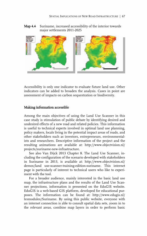
SPATIAL IMPLICATIONS OF NEW ROAD INFRASTRUCTURE | 67
Map 4.4 Suriname, increased accessibility of the interior towards major settlements 2011-2025
Accessibility is only one indicator to evaluate future land use. Other indicators can be added to broaden the analysis. Cases in point are assessment of impacts on carbon sequestration or biodiversity.
Making information accessible
Among the main objectives of using the Land Use Scanner in this case study is stimulation of public debate by identifying desired and undesired effects of a new road and related policies. This information is useful to technical experts involved in optimal land use planning, policy makers, locals living in the potential impact areas of roads, and other stakeholders such as investors, entrepreneurs, environmental-ists and researchers. Descriptive information of the project and the resulting animations are available at: http://www.objectvision.nl/ projects/suriname-new-infrastructure. See also Van Dijck 2013 Chapter 8. The Land Use Scanner, in-cluding the configuration of the scenario developed with stakeholders in Suriname in 2013, is available at: http://www.objectvision.nl/ demos/land use-scanner-training-edition-suriname. This internet page is particularly of interest to technical users who like to experi-ment with the tool. For a broader audience, mainly interested in the basic land use map, the infrastructure plans and the results of the Land Use Scan-ner projections, information is presented on the EduGIS website. EduGIS is a web-based GIS platform, developed for educational pur-poses. The information can be found at: http://www.edugis.nl/ lesmodules/Suriname. By using this public website, everyone with an internet connection is able to consult spatial data sets, zoom in to the relevant areas, combine map layers in order to perform basic

68 | MARTIN VAN DER BEEK, RONNIE LASSCHE AND MATHILDE MOLENDIJK
Map 4.5 EduGIS website, Suriname section
visual analyses. This allows users to find out about the distance be-tween proposed or planned infrastructural works and the location of villages, concessions for timber logging and (gold) mining, or areas with high levels of biodiversity. Map 4.5 distinguishes the maps col-lected at the left-hand side of the menu under ‘lagenselectie’ (layer selection). Each map can be displayed in the screen, and different map layers can be combined, depending on the interest of the user. To explore the datasets or maps, an educational module has been developed, shown at the right-hand side of the menu.
Reflections
In the Suriname case study relevant geo-information on land use and infrastructure could be collected to generate a base map of the cur-rent land use that was considered appropriate for analysing impacts

SPATIAL IMPLICATIONS OF NEW ROAD INFRASTRUCTURE | 69
of new infrastructure. With the Land Use Scanner the effects of the infrastructure plans were modelled based on an operational scenario. The local suitability of land units were modelled with multiple maps on the current land use, physical properties, planning poli-cies and distance relations. We experimented as well with different rules in the model, attaching different weights to the suitability fac-tors. One scenario was established in a stakeholder training session, resulting in a higher quality of the model results, and, more im-portantly, contributing to a higher awareness of suitability factors that may influence land use in the future. All information – ranging from animations of changes in land use, to maps, data and software – has been made accessible to all on the internet. Additional research may expand our understanding of the impact of new physical infrastructure by investigating impacts in neighbouring countries, since impacts of newly planned infrastruc-ture do not end at the border. Moreover, the impact areas could be analysed in more detail by including regional demands at the district level. Plans and accompanying assumptions at the district level of Suriname could be incorporated into the model, leading to a more comprehensive investigation of impacts on the spatial environment. Finally, as soon as information becomes available on the exact loca-tion or trajectory of new physical infrastructure, the model should re-run automatically all procedures including this new information. The method can be applied at a smaller scale as well, for instance to assess the spatial impacts of infrastructural plans in the Amazon region. To evaluate the resulting future land use maps, several indi-cators can be adopted: accessibility, as has been discussed in the fifth section, and also carbon sequestration and biodiversity. In general, these data, tools and scenarios enable the construction of meaningful images of future impacts of road construction on the use of land and resources. Stakeholder participation plays a vital role in the preparatory pro-cess of defining the relevant parameters for the model. Results of modelling may subsequently be used to discuss desired and non- desired outcomes with a larger group of stakeholders. Counteracting measures may be discussed with stakeholders, and new rules can be fed into the land use model to calculate whether these improved countermeasures sort the desired effect on future land use. In this way land use models can support the optimisation of routing of new road and the development of participatory policies regarding infra-structural proposals and plans.

70 | MARTIN VAN DER BEEK, RONNIE LASSCHE AND MATHILDE MOLENDIJK
References
Alonso, W.A., Location and Land Use: Toward a General Theory of Land Rent, Har-vard University Press, Cambridge, 1964.
Boksteen, L.W, Strategische Analyse en Participatief Actieplan voor Zuid-Ooost Suri-name. Deelstudie Impact Vergroting Beschikbare Hoeveelheid Water in het Be-staande Brokopondo Stuwmeer, 2009. [Online] Accessible at: http://www.cedla. uva.nl/20_research/pdf/vDijck/suriname_project/Deelstudie.pdf. Accessed 24 01 2014].
Chomitz, K., and Gray, D.A., Roads, ‘Land Use and Deforestation: A Spatial Model Applied to Belize’, The World Bank Economic Review, Volume 10, 1996, pp. 165-174.
Conradi P., ‘De Nieuwe Kaart van Suriname’, Geologie (KNAW) 01.01.03, 2003. [Online]. Available at: http://www.knag.nl/index.php?id=640&tx_ttnews%5 Bswords%5D=gis&tx_ttnews%5Bpointer%5D=89&tx_ttnews%5Btt_news%5D=256&tx_ttnews%5BbackPid%5D=502&cHash=4b9be18c7e. Accessed on January 28, 2014.
Dekkers, J., P. Retveld, ‘The Adoptation of Geo-ICT in Economics: Increasing Oppor-tunities for Spatial Research in Economics’, in H.J. Scholten, R. van de Velde, and N. van Manen (eds), Geospatial Technology and the Role of Location in Science, The GeoJournal Library 96, Springer, York, 2009.
Dijck, P.van, The Impact of the IIRSA Road Infrastructure Programme on Amazonia, Routledge, London and New York, 2013.
Hoyan, J., ‘Spatial Allocation of Future Residential Land Use in the Elbe River Basin’. Environment and Planning B’ Planning and Design, Volume 37, Number 5, pp 911-928, 2010.
Joly, C. and T. Kuyper, GIS Kaarten voor Impactanalyse, Project Strategische Analyse en Participatief Actieplan voor Zuidoost Suriname, FALW – VU, Amsterdam, 2010.
Kaiowiz, D., P. Mendez, Atie Puntodewo, and J. Vanclay , ‘Spatial Regression Analysis of Deforestation in Santa Criz, Bolivia’ in: Wood, C.H. and R. Porro (eds), Defor-estation and Land Use in the Amazone, University Press of Florida, Gainesville, 2002.
Kloterman, R.E. and C.J. Pettit, ‘Guest Editorial: An Update on Planning Support Systems’, Environment and Planning B, Volume 32, pp 477-484, 2005.
Kooen, E. and Stillwell, J. ‘Modelling Land-Use Change; Theories and Methods’ Chap-ter 1, in: Koomen, E., J. Stillwell., A. Bakema and H.J. Scholten (eds.), Modelling Land-Use Change; Progress and Applications, Springer, Dordrecht, pp. 1-21, 2007.
Komen, E. and J. Borsboom-van Beurden, J. (eds.) ‘Land-Use Modeling in Planning Practice’, Geojournal Library, Volume 101, Heidelberg, Springer, 2011.
Kooen, E., A. Koekoek. and E. Dijk, ‘Simulating Land-Use Change in a Regional Plan-ning Context’, Applied Spatial Analysis and Policy , Volume 4, Number 4, 2011, pp. 223-247.
Kraneburg, R. and H. Lutchman: ‘Een Nieuwe Kaart voor Een Land Waar Ruimtelijke Planning Niet Bestaat’, Geologie (KNAW) 01.10.07, 2007.[Online] Available at: http://www.knag.nl/..fileadmin/geografie/index.php?id=640&tx_ttnews%5Bswords%5D=landbouw&tx_ttnews%5Bpointer%5D=9&tx_ttnews%5Btt_news%5D=885&tx_ttnews%5BbackPid%5D=502&cHash=86f4121570. Accessed on January 28, 2014.
Krooneberg, S., ‘Ik Denk Dat Het met Die Klimaatverandering Wel Meevalt’, inter-view, November 17, 2009. [Online] Available at: http://www.salomon kroonenberg.nl/doc/Een-menselijk-sleutelgat-van-dertig-jaar.html. Accessed on January 28, 2014.

SPATIAL IMPLICATIONS OF NEW ROAD INFRASTRUCTURE | 71
Kruman, P., ‘What’s New About The New Economic Geography?’ Oxford Review of Economic Policy , Volume14 , Number 2,1998, pp. 7-17.
Lavale, C., Baranzelli, C., Batista e Silva, F., Mubareka, S., Rocha Gomes, C., Koomen, E. and Hilferink, M., ‘A High Resolution Land Use/Cover Modelling Framework for Europe: Introducing the EU-ClueScanner100 Model in: B. Murgante, O. Gervasi, A. Iglesias, D. Taniar and B.O. Apduhan, (eds.), Computational Science and Its Applications – ICCSA 2011, Part I, Lecture Notes in Computer Science Volume 6782. Springer-Verlag, Berlin, 2011, pp. 60-75.
Lutchman, H. and A. Karssen, Kaart van Suriname, Stichting Leermiddelen en Leer-projecten, Amsterdam, 2003.
Mc Fadden, D.L., Modelling the choice of residencial location, in: A. Karlsqvist, L. Lundqvist, F. Snickars and J. W. Weibull (eds) Spatial Interaction Theory and Planning Models, Amsterdam, 1978, p. 75 – 96.
Molendijk, M., M. van der Beek and R. Lassche, ‘Spatial Implications for Land and Resources of New Road Infrastructure in Suriname: Land Use Scanner’; ‘Opbouw Kaart Huidig Grondgebruik voor Land Use Scanner Suriname’; ‘Geologie van Su-riname, Een Voorstudie voor Land Use Scanner Applicatie’ in: P. van Dijck and M. Wallis, Handleiding bij Seminars en Trainingen over Planning en Beleid voor Op-timal Landgebruik in het Kader van Grootschalige Infrastructurele Werken in Su-riname, CEDLA and WWF, Paramaribo,2013.
One Geology Project, On Mapping a New Geological Map for Suriname, 2011. [Online] Available at: http://www.gov.sr/sr/ministerie-van-nh/actueel/geological-mapping-on-the-border-suriname-brazil.aspx. Accessed on 28 January, 2014.
OSM, n.s., Open Street Map. Available at: Open Street Map data [Online]. Available at: http://www.openstreetmap.org. Accessed 24 January 2014.
Planatlas Suriname, Stichting Planbureau Suriname, Afdeling Regionale Planning en Ruimtelijke Ordening, Organization of American States, Map 5B of Mineral Re-sources, 1988, based on the ‘Metallogenic Map’ of E.H. Dahlberg 1975.
Porter, M.E., The Competitive Advantage of Nations, Free Press, New York, 1990. Porter, M.E., ‘Clusters and the New Economics of Competition’, Harvard Business
Review, Volume 76, Number 6, pp. 77-90, 1988. Rudel, T.K., Tropical Forests. Regional Paths of Destruction and Regeneration in the
Late Twentieth Century, Colombia University Press, New York, 2005. Sheridan, P., J.O. Schroers and E. Rommelfanger,’ GISBased Modelling of Land-Use
Systems; EU Common Agricultural Policy Reform and Its Impact on Agricultural Land Use and Plant Species Richness’, Chapter 2 in: Koomen, E., J. Stillwell, A. Bakema and H.J. Scholten. (eds.), Modelling Land-Use Change; Progress and Ap-plications, Springer, Dordrecht, pp. 375-389, 2007.
Te Linde, A.H., P. Bubeck, J.E.C.Dekker, H. De Moel and J.C.J.H. Aerts,’ Future Flood Risk Estimates Along The River Rhine’, Natural Hazards and Earth System Sci-ences, Volume 11, Number 2, 2011, pp. 459-473.
Verburg, P.H., P.P. Schot, M.J. Dijst and A. Veldkamp, ‘Editorial: Predicting Land-Use Change’, Agriculture, Ecosystems and Environments, Volume 85, 2004, pp. 1-6.


5.
TROUBLESOME ASSESSMENT: CONTROVERSIES OVER THE MANAUS-PORTO VELHO HUB AND ITS IMPACT ASSESSMENT
MARINELLA WALLIS
Introduction
The construction and pavement of highways in Amazonia have raised fierce debate over the last three decades. Among the most contested road construction projects in Amazonia is the proposed pavement of the BR-319 connecting Manaus with Porto Velho. The controversy over the pavement of the road itself as well as the as-sessment of its potential socio-economic and environmental impacts is related to the significant environmental consequences of the road as it may contribute to the opening of the western part of Brazilian Amazonia which so far has been among the least accessible and af-fected parts of Amazonia. At the same time, the road may play a key role in connecting the industrial hubs of Manaus and São Paulo. In order to get a license for building the road, the Ministry of Transport had to undertake a strategic environmental assessment (SEA) as required by IBAMA, the federal environmental agency. The assessment study that was subsequently undertaken was comprehensive and developed by a large multidisciplinary team of researchers. However, the complications related to this SEA have continued for a long period starting 2005 until the time of writing this chapter. By now (May 2014), the license has not been issued and the procedure not yet finished. The controversy was clearly reflected by two contradictory presidential messages. Initially, in 2008 Presi-

74 | MARINELLA WALLIS
dent Lula, during his visit to Manaus, announced that the road was to be built in due course. Subsequently, President Dilma Rousseff an-nounced during her visit to Manaus in 2011 that the construction of the road was cancelled. These messages reflect the conflicting charac-ter of the plans and policies of the different government agencies in-volved, which eventually led to a stand-still in the licensing procedure. The study is organized as follows. The following section focuses on the background and context of the plan to improve and pave the BR-319 in order to clarify the conflictive character of the project and the assessment study. The third section focuses on the policy context of the environmental impact assessment itself, and in particular its plan of action. Section four deals with some major points of criticism on the assessment study that played a key role in the debate on the assessment and its implications. The final section presents some concluding observations.
Background and context of the BR-319
Federal policy towards the northern region
The BR-319 was built in the 1970s during the era of the military re-gime as part of a larger plan to open Amazonia and connect the re-gion with the rest of Brazil. Main objectives of the strategy were im-provement of accessibility of the region, and support for the devel-opment of agriculture, cattle breeding, forestry, timber logging, and more generally the exploitation of natural resources. The policy of occupation started with the Plano de Integração Nacional (PIN 1970) and was followed by other land-use policy incentives (Rodrigues-Filho et al. 2012). Priorities were reflected by the well-known slogans of the time: integrar para não entregar – integrate the Amazon into Brazil to save it from falling into foreign hands – and uma terra sem homens para homens sem terra – a land without people for people without land. The policy clearly was not aimed at supporting the indigenous population. These policies resulted in a shift in the com-position of the regional population with an increasing number of agricultural smallholders with a clear interest in road infrastructure to facilitate access to markets. For over 30 years, the northern region has served for the federal government as an area to be colonized for security, economic and social reasons. Developmentalist policies pursued by successive gov-ernments involved the construction of a series of major roads to link the area with population centres in the northeast and south. Along the roads colonies were established to settle migrants. In support, generous tax and credit incentives were provided to attract settlers and investment. The resulting land‐use patterns were erratic and incompatible with sustainable development. Starting in the late

TROUBLESOME ASSESSMENT | 75
1980s, Brazilian governments along with donors and NGOs proposed territorial planning in support of a more orderly type of land use in the Amazon region (Mahar 2000). The initial road-building of the BR-319 in the 1970s was executed without consideration of economic viability or environmental im-pacts and even a thorough estimation of expected traffic intensity was not made (Fearnside and Graça 2006). The road was built hasty, its use was limited, maintenance was poor and so was its condition. Limited use of the road was due to difficult terrain and relative high transportation costs as compared to river transport. In 1988, the bus line from Manaus to Porto Velho was suspended for security reasons and passing the road was forbidden. Rumours have it that local barge owners ruined the road on purpose as they feared substantial loss of income due to competition by road transport.
Logistics at the regional level
The only way to transport goods between Manaus and the south-eastern part of the country (São Paulo and Rio de Janeiro) so far is by air or water. The growth of Manaus and its industrial heart, the Polo Industrial de Manaus, stimulates local interest in the restoration of the road to Porto Velho. Eventually in the first tranche of the Pro-grama de Aceleração do Crescimento (PAC) nearly 700 million reais (about 262.5 million US dollars in 2005) were budgeted; according to plan the road would be ready by 2011. No economic feasibility study was made notwithstanding the substantial investment involved (Fleck 2009). Since the 1980s Brazilian law requires an EIA-RIMA (an envi-ronmental impact assessment and its report) to assess socio-environmental impacts of the building of infrastructure. However, this requirement was disputed in the case of the BR-319 as these infrastructure works were considered to be a restoration of an already existing road rather than construction of a new road. This point of view was opposed by the argument that the significance of the biodi-versity in the area adjacent to the road, which had hardly been used over a long period, required an impact assessment. The BR-319 is a road of almost 900 km but the required EIA, to be executed under the supervision of IBAMA, covers just over 400 km: from Manaus at km 250 until km 656. The reason for this spatial limitation is that the stretch of road situated more or less in the mid-dle of the trajectory must be regarded as new, as no traffic had passed for a long period of time due to the poor condition of that stretch of road, as compared to all the rest of the road which was in a better condition and in use. Map 5.1 shows the road and its impact area between the River Purus and the River Madeira, both tributaries to the Amazon River.

76 | MARINELLA WALLIS
Map 5.1 The BR-319 and adjacent territory between the rivers Purus and Madeira
Source: Adapted from UFAM 2009b. Moreover, the impact area is of significance for the livelihood of in-digenous peoples. Road improvement may facilitate migration into the area and add to the risks involved in the opening of the territory.
Broader pressures in support of the BR-319 connection
Manaus plays a central role in the development of infrastructure in the north of Brazil. In the lay-out of IIRSA Manaus is a pole in the Amazon Hub, which connects the Pacific and Atlantic Oceans as shown in Map 5.2. Moreover, the BR-174 which is part of the IIRSA Guyana Shield Hub connects Manaus with Venezuela and with the Guyanas and the ports at the Caribbean Sea. Substantial intra‐regional trade flows have developed between Manaus and Porto Velho, which is to a large extent a transito connec-tion with the industrial centre of São Paulo. Goods are transported by road between São Paulo and Porto Velho and by ship between Porto Velho and Manaus. A road connection between the two cities would facilitate trade significantly. Moreover, such a road connection for its part may link up with the IIRSA Peru‐Brazil‐Bolivia Hub, thus creating a connection with the Pacific Ocean. The infrastructure

TROUBLESOME ASSESSMENT | 77
Map 5.2 IIRSA hubs in the north of South America
Source: Adapted from www.IIRSA.org. programme PAC includes more plans to enhance the connectivity in the northern region and the exploitation of economic opportunities due to a convenient location from the perspective of global trade, abundant availability of hydroelectricity and natural resources. These developments and potentials contribute to the pressure for a road connection between Manaus and Porto Velho. In addition to these broader regional developments, the Ministry of Transport developed plans for a local road network in connection with the BR-319. As put by the National Department of Transport Infrastructure of the Ministry of Transport (DNIT): the reconstruc-tion of the BR-319 in combination with the conservation of the stretches that are already in good shape will be fundamental to create a hub of integration and end the isolation of important settlements in the state of Amazonas (UFAM 2009b). However, such a road will increase migration into the area (Fearnside and Graça 2006 and 2009). Crucial for the potential impact of the BR-319 are the plans to construct a series of roads to connect the municipal settlements along the rivers Madeira and Purus with the highway. One of these roads is planned to cross the Purus River at Tapuã and continue in western direction towards Tefé and Juruá. Such connections support small farmers in the settlements along the road but open as well large forested areas in the western part of the state of Amazonas. It should be noted that migration into these areas is facilitated as well by the Transamazônica (BR-230) which was built in the early 1970s with the explicit purpose to stimulate migration into the area. As shown in Maps 5.1 and 5.3 the intersection of the two roads is at Humaitá, 220 km north of Porto Velho. The risks of significant and large-scale deforestation and change in land use may be assessed more accurately when the construction

78 | MARINELLA WALLIS
of the BR-319 is put in a regional perspective. There is an accumula-tive effect of the main drivers of deforestation in the region, which are: the building of the BR-319 and its vicinal roads; the BR-317 in the western Amazon state of Acre, which was licenced recently; and the BR-364 – also known as the Pacific Road – that links Cuiabá in the state of Mato Grosso with Rondônia and via Porto Velho with the state of Acre and Peru. See Map 5.3.
Context of the EIA/RIMA
After the federal government announced the reconstruction of the BR-319, arguments started and by mid-2005 a judicial decision by the Ministry for the Environment imposed a ban on all reconstruction works on the BR-319. Moreover, the decision required the DNIT to present an EIA/RIMA to IBAMA in order to obtain a license. In addi-tion, a Federal Decree in early 2006 issued an Area under Provisional Administrative Limitation (ALAP) to create a more explicit legal regu-lation of the area and to facilitate surveys to be carried out in order to create conservation units along the road. The ALAP covered the in-terfluvial area between the Purus and Madeira rivers and prohibited construction works within the area. Map 5.4 shows conservation units already in existence and units to be created, either as fully pro-tected areas or as areas permitting only sustainable activities. The map shows the important role destined to these conservation units in order to contain the impacts of road construction. The DNIT commissioned the EIA/RIMA in 2007. The study was made by a team most of which were researchers at the Federal Uni-versity of Amazonas (UFAM). A group of 57 researchers from a wide range of academic disciplines was contracted. The process was su-pervised by IBAMA. The available budget amounted to 1.5 million US dollar. (Van Dijck 2013). The final results of the study were planned to be issued in 2009. At the time that the EIA/RIMA was initiated, Alfredo Nascimento was Minister of Transport. Later on, in March 2010, Nascimento would be running for governor of the state of Amazonas with the rebuilding of the BR-319 as one of his selling points. In September 2008, after Minister of Transport Nascimento had published that the environmental licence would be ready and issued, President Lula announced the reconstruction of the road during his visit to Manaus in October 2008. Thereupon, the Minister for the Environment, Carlos Minc, passed a provision that constituted a 60-days period of suspension of the licencing procedure and created the

TROUBLESOME ASSESSMENT | 79
Map 5.3 Federal roads (paved, unpaved, and planned) in northern Brazil
Source: Adapted from Ministry of Transport, http://www.mapa-brasil.com/Mapa_ Rodoviario_Regiao_Norte_Brasil.htm. Working Group BR-319 to oversee the EIA/RIMA process. As formu-lated, the main objective was ‘to define, plan and present preventive measures to be taken in relation to the impacts of the road construc-tion, in order to halt deforestation and de-characterization of the Amazonian biomass along the road’ (Parecer Técnico 2009). The Minister of the Environment ordered as well the assessment and quantification of the costs of implementing and maintaining the ten planned conservation units along the BR-319 (IDESAM et al. 2009). The intention of the Ministry of the Environment to demand a budg-eting plan to implement them shows the recognition of conservation units as a strong governance instrument.

80 | MARINELLA WALLIS
Map 5.4 Area under Provisional Administrative Limitation (ALAP)
Source: Grupo Permanente e Trabalho Interministerial sobre Desmatamento na Amazônia (http://www.casacivil.gov.br/camaras/grupos/amaz_legal).
Conservation units
Conservation units are part of the National Sy stem of Conservation Units (SNUC). The Department for Sustainable Development of the state of Amazonas opted for the creation of such units along the BR-319. The department considered conservation units effective instru-ments to create a barreira verde, a ‘green wall’ to impede negative impacts of a road. These conservation units help safeguarding the integrity of ecosystems and their environmental services, such as soil conservation and watershed protection, nutrient recycling, and cli-mate regulation. Moreover, they protect the habitat and culture of the indigenous peoples living in these areas (Veríssimo et al. 2010). The most important aspect of the SNUC, which is embedded in the Códi-go Florestal (Forest Law), is the legal support it provides for conserva-tion governance. However, the SNUC is far from a consolidated system and a number of major implementation and governance challenges still have to be addressed. Designation of an area as protected and demar-cation of its boundaries is a complicated process as land titles may be unclear. In the case of public land three different tiers of government – at the federal, state or municipal level – may be the owner, all hav-ing their own policy objectives. Moreover, different priorities con-cerning the specific nature of protection itself – ranging from fully protected areas towards areas for sustainable use – may be an addi-tional complicating factor.

TROUBLESOME ASSESSMENT | 81
Note that until recently most protected areas were located outside the potential impact areas of economic activities and hence required limited protection only. At present however, 84 per cent of protected areas are situated within the potential impact area of economic activi-ties and face increasing pressure due to the construction of infra-structure – e.g., roads, electrical grid – and the expansion of agricul-ture lands (Barreto and Childress 2010).
Questioning legality
Notwithstanding the issuing of the ALAP a construction company contracted by DNIT started works half a year later. These construc-tion works were claimed to be in accordance with the directives of the National Programme on Environmental Regularization of Federal Paved Roads. According to this view, the works did not involve con-struction of a road but its restoration, for which no EIA/RIMA was required. However, after inspection IBAMA concluded that the works involved road pavement and therefore were illegal. This position was upheld by the Counsel for the Prosecution of the State of Amazonas (Parecer Técnico 2009). These legal conflicts did not bode well for an EIA/RIMA to be undertaken, as became apparent during the conflict over the terms of reference. As put by Rivas, the coordinator of the assessment study: ‘The impossibility to deliver a final version of the terms of reference in time was an obstacle for the assessment team to produce the study in the appropriate way, and required significant adjustments and several revisions at late stages’ (Van Dijck 2013, Chapters 9 and 10). In this conflictive context Operation Razor-blade is noteworthy. In July 2007 the Federal Police put the BR-319 project ‘under suspicion’ while dismantling a corruption scheme of 100 million reais, which involved the construction company and over 225 persons, including ministers, senators, parliamentarians and staff members. Minister Nascimento and the Governor of the State of Amazonas were among those involved (IDESAM et al. 2009).
Critical reception of the EIA/RIMA
The EIA has been criticized from several angles including IBAMA, INPA and NGOs like IDESAM and others. IBAMA considered the EIA/RIMA insufficient as a basis for providing a licence and conse-quently the project came to a halt. According to IBAMA, the report suffered from flaws in the analysis of physical and biotic aspects, and from serious shortcomings in the socio-economic analysis. Moreover, it fell short in making an adequate assessment of potential impacts of road construction and the formulation of proposals to mitigate such

82 | MARINELLA WALLIS
impacts. IBAMA criticized the recommendations for being excessively dependent on the role of protected areas and indigenous lands in mitigating negative impacts, which was rather premature in view of its lack of manpower and financial resources to manage such areas. The majority of the 61 indigenous lands – more than a third of which still had to be legally acknowledged – is under threat and subject of conflict. More worrying is the situation of the four isolated indige-nous peoples whose territory yet had to be demarcated.
Delineation of the impact area
The delineation of the impact area was also a point of critique. The size of the potential impact area has major consequences for the organization of the study – including the baseline study and invento-ries of data – and for the policy implications of its findings. In addi-tion, delineation of the potential impact area has implications for the selection of public institutions to be consulted that have administra-tive and jurisdictional competence in the area. Underestimation of the spatial dimensions of the potential impact area may result in underestimation of de facto impacts: the potential positive and negative socio-economic and environmental effects and related values, and hence of required policy measures to mitigate impacts or to compensate for damage or revenues forgone. Accord-ing to the IDESAM study, the delineation of a 5 km wide impact area on both sides of the road as made in the EIA/RIMA – implying an impact area of 895,387 hectare – is too limited and does not fit the definition of the terms of reference, indicating that: ‘the area of direct impact should constitute areas that are threatened in a real sense or in a potential way by the direct impacts of the implementation of the road, as well of the associated and resulting activities’ (IDESAM et al. 2009). The study states that these boundaries have not been based on technical criteria and that areas adjacent to the road and liable to illegal logging or conversion into cultivated land must be included in the impact study. Moreover, such a narrow zone is not in line with findings of studies on the impacts of roads on land use conversion and deforestation Map 5.5 shows the spatial impacts of the use of an impact zone of 10 km instead of five km. It shows that quite a few indigenous lands and conservation units located or planned to be located in the inter-fluvial area between the River Purus and the River Madeira will be affected, and that delineation of a 10 km wide zone on both sides of the road, including vicinal roads, would imply an area comprising 3.6 million hectare instead of nearly 0.9 million hectares. Fearnside and Graça, too, underpinned the significance of including the vicinal
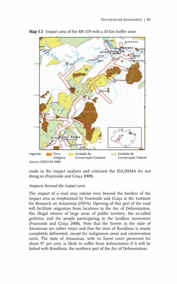
TROUBLESOME ASSESSMENT | 83
Map 5.5 Impact area of the BR-319 with a 10 km buffer zone
Legenda: Terra
Indígena Unidade de
Conservação Estadual Unidade de
Conservação Federal Source: IDESAM 2009. roads in the impact analysis and criticized the EIA/RIMA for not doing so (Fearnside and Graça 2009).
Impacts beyond the impact area
The impact of a road may extend even beyond the borders of the impact area as emphasized by Fearnside and Graça at the Institute for Research on Amazonia (INPA). Opening of this part of the road will facilitate migration from locations in the Arc of Deforestation, like illegal owners of large areas of public territory, the so-called grileiros, and the people participating in the landless movement (Fearnside and Graça 2006). Note that the forests in the state of Amazonas are rather intact and that the state of Rondônia is nearly completely deforested, except for indigenous areas and conservation units. The state of Amazonas, with its forest cover preserved for about 97 per cent, is likely to suffer from deforestation if it will be linked with Rondônia, the northern part of the Arc of Deforestation.

84 | MARINELLA WALLIS
Another point of criticism relates to the expectations concerning traffic flows: 375,000 passengers are expected to travel by bus from 2012 onwards, the date of the expected inauguration of the road, which is remarkably high as compared to the number of inhabitants of the city of Porto Velho, which is about the same. A major objection of Fearnside and Graça against the EIA/RIMA is the arbitrariness and selectivity in the use of spatial dimensions of probable negative and positive impacts of the road. Assessments of negative impacts are limited to the indirect impact area covering the area between the rivers Purus and Madeira, while benefits are claimed for a much wider area, including the city of Manaus and agricultural areas in Mato Grosso (Fearnside and Graça 2009).
Problematic aspects of assessment
Regional planning
A specifically serious risk in the context of the assessment is that the recommendations and the strategic action plan are strongly linked to region-wide conservation policies that are not fully consolidated and are still the object of political struggle and lobbying. The BR-319 EIA/RIMA is explicitly embedded in the Plan for Sustainable Ama-zonia – Plano Amazônia Sustentável, PAS – (UFAM 2009a), which is coordinated by the Secretariat of Strategic Affairs. This plan originat-ed from an initiative by the federal government to create regional development plans to diminish interregional economic inequality. Construction of infrastructure is considered a major tool to diminish these inequalities. The first PAS for the period 2004-2007 was issued in 2003 and many updates were to follow. Becker and Galvão (2010) note that the initial PAS dealt with economic development and environmental concerns in an integrated manner. As put by the Ministry of National Integration (2005), one of the objectives of the PAS is to offer an alternative for the tension between ‘environmentalism’ and ‘devel-opmentalism’. However, the 2008 version of the PAS abandons that strategy and treats environmental concerns as a separate issue. The case of the building of the BR-163 is a striking example. It reduces to a large extent the integrated idea of the PAS 2003 as the road just penetrates Central Amazonia, an area suffering from increasing economic pressures and moving frontiers and – as laid down in the PAS 2003 – requiring a more balanced and integrated policy ap-proach (Becker and Galvão 2010).

TROUBLESOME ASSESSMENT | 85
Vulnerability of conservation policies
Conservation policies and economic development priorities are con-tinuously in conflict and outcomes are hard to predict. Small and big farmers in the region and their representatives in congress, the so-called ruralistas, are continuously framing their rights and lobbying for more land. In June 2012, the Código Florestal (Forest Law) was modified after a lengthy period of protests, manifestations and de-bates in congress. The voting on the Código Florestal is a clear exam-ple of how political forces can change prospects of conservation gov-ernance. The most recent alterations of the Forest Law imply total amnesty without restriction for perpetrators of laws that prohibit deforestation; a relaxation of the obligation of forest restoration for past deforesters and a very flexible status of the conservation units. The functioning of conservation units was further threatened by a proposal for amending the constitution. PEC 215 involves a shift in the competence to demarcate indigenous lands away from the Feder-al Government to the National Congress. The proposal – target of many protests by indigenous people – would signify that politics and lobbies are able to influence the outcome, making it feasible to change the status of already demarcated areas and hamper the crea-tion of new areas.
Final observations
Impressive results from the EIA/RIMA
Although procedures and policy context prevented the SEA to func-tion as an effective and efficient policy tool so far, it needs to be em-phasized that the assessment study itself has been an innovative and comprehensive approach towards understanding potential impacts of a major road on an environment that is of great value from an ecolog-ical point of view as well as from the perspective of the livelihood strategy of the indigenous peoples living in the potential impact area. A thorough investigation was made of the living conditions of indig-enous peoples in the area. Their representatives were involved in the consultation process in order to analyse their perceptions and priori-ties concerning the road and measures to mitigate its negative im-pacts. This investigation resulted in a series of 24 recommendations for policy initiatives. However, in view of the understaffing of institu-tions involved in the management of conservation units and indige-nous lands, the EIA/RIMA observes that cooperation among relevant institutions is required in order to realize strong governance. To make governance work and manage effectively the impact area, even the alternative approach of establishing public-private partnerships is recommended (UFAM 2009a).

86 | MARINELLA WALLIS
Another innovative aspect of the assessment study is the econom-ic valuation of the forest, involving an assessment of the sum total of the indirect use values, option value and existence value. The sum total of the loss of these values was assessed in four scenarios: a sce-nario with no governance (10.5 billion reais); a scenario with weak governance (5.3 billion reais); a scenario with moderate governance (2.6 billion) and a scenario with strong governance (0.5 billion reais), showing the economic significance of good management and effec-tive protection and governance (UFAM 2009a).
The importance of policy context
The EIA related to the reconstruction of the BR-319 has demonstrat-ed that the policy context of an assessment is of significance for its outcomes and impact. The rationale may be put into question and the terms of reference of the EIA may be a bone of contention be-tween government bodies, as a consequence of which the objectives and terms of reference may lack precision and focus. Moreover, the political context and the relationship between the partners deter-mined to a certain extent the climate of cooperation and the way the study has progressed. As the DNIT-department of the Ministry of Transport commissioned the EIA, the research team seems to have developed the study on the basis of the position that the road was inevitable and that an alternative mode of transportation, such as a railway, was no option. In that context, the proposed option to recon-struct the BR-319 in combination with environmental management and a policy of conservation units to control negative environmental spillovers was reasonable. However, to increase the capability to manage environmental impacts effectively and efficiently, a number of preconditions has to be met in view of the limited capabilities and willpower to implement strong governance in the potential impact area. In that context the question arises whether such critical factors and considerations need also to be included in the assessment study itself. Not unlikely, the delay in releasing the licence by IBAMA may have been a blessing in disguise. In the course of time, views, prefer-ences, positions and interests may change, and political priorities may shift towards more sustainable options. Moreover, the overall political landscape, and with it the policy context of EIAs and deci-sions concerning road construction in environmental sensitive areas, may change once more. But the opposite may come true as well. Due to deteriorating economic conditions, or just to growing ambitions, the pressure for economic development in the Amazon may build up. The licensing process related to the BR-319 shows similarities with procedures related to other roads in South America, as shown in a recent study of the effectiveness of assessment studies of mega-

TROUBLESOME ASSESSMENT | 87
road projects (Kis Madrid et al. 2011). One of the major outcomes of the study is that effectiveness of such studies has been reduced sig-nificantly by the lack of capabilities of governments and institutions to implement the recommendations of the strategic action plan, es-pecially when there is a clear lack of capabilities, commitments and institutional arrangements to facilitate actual implementation. For a series of recommendations to enhance the effectiveness of SEAs, see Kis Madrid et al. 2011. See also Van Barneveld in Chapter 6 of this Cuaderno. It may be useful to have a critical look at the policy tool of a SEA itself and assess its function and limitations. The integrated approach for sustainable development as described in the PAS 2003 and pro-posed by Becker and Galvão (2010) may be considered an interesting alternative for the actual developments as described in this chapter. A SEA or EIA/RIMA may serve as a building block for such an alterna-tive approach but the political arena was apparently not supportive for linking the outcomes of the assessment with the overall policy environment of the country and the institutional setting. As noted by Kis Madrid et al. (2011): ‘[i]n terms of the context of SEA (…), coun-tries need adequate capacities: legal frameworks for conducting SEA; institutional, operative, coordination and monitoring capacities; polit-ical will and commitment; and financial resources’. Without a sup-portive context the impact of even a high-quality SEA will be limited as follows from this study.

88 | MARINELLA WALLIS
References
Barreto, P. and M.D. Childress, ‘Land Tenure and Climate Change Mitigation in the Brazilian Amazon’, Par. 6.2. in: Deininger, K., et al., Innovations in Land Rights Recognition, Administration, and Governance, The World Bank, GLTN , FIG, and FAO, Washington, D.C., 2010.
Dijck, P. van, The Impact of the IIRSA Road Infrastructure Programme on Amazonia, Routledge, London and New York, 2013.
Fearnside, P.M. et al., ‘Modelagem de Desmatamento e Emissões de Gases de Efeito Estufa na Região sob Influência da Rodovia Manaus-Porto Velho (BR-319)’, Revis-ta Brasileira de Meteorologia, Volume 24, 2009.
Fearnside, P.M. and P.M.L.A. Graça, O EIA/RIMA da Rodovia BR-319: Decisão Crítica sobre a Abertura do Coração da Amazônia ao Desmatamento, Instituto Nacional de Pesquisas da Amazônia‐INPA, Manaus, 2009.
Fearnside, P.M. and P.M.L.A. Graça, ‘BR-319: Brazil’s Manaus-Porto Velho Highway and the Potential Impact of Linking the Arc of Deforestation to Central Amazo-nia.’ Environmental Management, Volume 38, Number 5, 2006, pp. 705-716.
Fleck, L. C., Efficiência Econômica, Riscos e Custos Ambientais da Reconstrução da Rodovia BR319, Conservation Strategy Fund, Lagoa Santa, Minas Gerais, 2009.
Folha de São Paulo ‘Amazônia Vira Motor de Desenvolvimento’, São Paulo, frontpage, 16 October 2011.
IDESAM et al., BR-319: Projeto de Re-Construção. Contribuições ao Processo de Licenciamento e Análise do Estudo de Impactos Ambientais, Manaus, 2009.
Kis Madrid C., G.M. Hickey and M.A. Bouchard, ‘Strategic Environmental Assessment Effectiveness and the Initiative for the Integration of Regional Infrastructure in South America (IIRSA): A Multiple Case Review’, Journal of Environmental As-sessment Policy and Management, Volume 13, Number 4, 2011, pp. 515-40.
Perz, S. et al., ‘ Socio-Spatial Processes of Unofficial Road-Building in the Ama-zon: Socioeconomic and Biophysical Explanations.’ Development and Change, Vo-lume 38, 2007, pp. 529-51.
Rede Temática Geoma, Análises Preliminares dos Efeitos Espaciais de Áreas Protegi-das na ALAP da BR 319. Grupo Permanente de Trabalho Interministerial sobre Desmatamento na Amazônia, Casa Civil da Presidência da República, Brasília, DF, Brasil, 2006.
Rodrigues-Filho, S. et al., ‘Road Development and Deforestation in Amazonia, Brazil’, Chapter 11 in: McNeill, D. et al., Land Use Policies for Sustainable Development: Exploring Integrated Assessment Approaches, Edward Elgar, Cheltenham, UK and Northampton, MA, 2012.
UFAM, Estudo de Impacto Ambiental – EIA: Obras de Reconstrução/ Pavimentação da Rodovia BR-319/AM, No segmento entre os km 250,0 e km 655,7. Universida-de Federal do Amazonas (UFAM), Manaus, Amazonas, 6 Volumes plus Anexos, 2009a.
UFAM, Relatório de Impacto Ambiental – RIMA: Obras de Reconstrução/ Pavimenta-ção da Rodovia BR-319/AM, No Segmento Entre os km 250,0 e km 655,7. Univer-sidade Federal do Amazonas (UFAM), Manaus, Amazonas, 2009b.
Veríssimo, A., et al., Áreas Protegidas na Amazônia Brasileira – Avanços e Desafios, Imazon and Instituto Socioambiental, Belém and São Paulo, 2010.
6.
STRATEGIC IMPACT ASSESSMENTS, STAKEHOLDERS’ PARTICIPATION AND GOVERNMENT POLICIES
BERT VAN BARNEVELD
Introduction
This chapter studies the contribution of stakeholders’ participation to strategic environmental assessments (SEAs) of the impacts of road construction in Amazonia, and the relationship between such SEAs and government policies. Public consultation and participation is a conceptual aspect of SEAs, and more generally an element of good governance. In several Latin American countries public consultation in impact assessments is required by law. The objective of public consultation is to collect information on stakeholders’ opinions re-garding proposed policies, plans and projects, their possible impacts, sensitive issues, risks and opportunities, tendencies and scenarios. The aim of the consultations is primarily to gather insight into the opinions of stakeholders regarding actions to mitigate negative im-pacts and to enhance opportunities and other strategic actions that are part of or related to the construction of transport infrastructure. Moreover, the consultation aims at obtaining information on region-al institutional capabilities and capacities that are required to imple-ment the strategic action plan. The chapter is based on the experiences of various SEAs in South America, with particular reference to the SEA of the Corredor Norte, the 1,390 km Bolivian branch of the international transport corridor
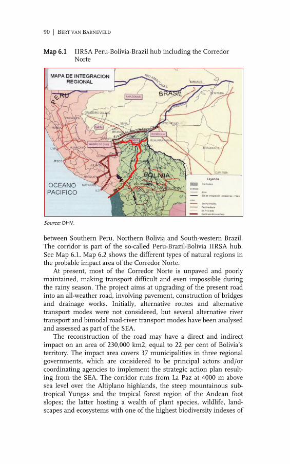
90 | BERT VAN BARNEVELD
Map 6.1 IIRSA Peru-Bolivia-Brazil hub including the Corredor Norte
Source: DHV. between Southern Peru, Northern Bolivia and South-western Brazil. The corridor is part of the so-called Peru-Brazil-Bolivia IIRSA hub. See Map 6.1. Map 6.2 shows the different types of natural regions in the probable impact area of the Corredor Norte. At present, most of the Corredor Norte is unpaved and poorly maintained, making transport difficult and even impossible during the rainy season. The project aims at upgrading of the present road into an all-weather road, involving pavement, construction of bridges and drainage works. Initially, alternative routes and alternative transport modes were not considered, but several alternative river transport and bimodal road-river transport modes have been analysed and assessed as part of the SEA. The reconstruction of the road may have a direct and indirect impact on an area of 230,000 km2, equal to 22 per cent of Bolivia’s territory. The impact area covers 37 municipalities in three regional governments, which are considered to be principal actors and/or coordinating agencies to implement the strategic action plan result-ing from the SEA. The corridor runs from La Paz at 4000 m above sea level over the Altiplano highlands, the steep mountainous sub-tropical Yungas and the tropical forest region of the Andean foot slopes; the latter hosting a wealth of plant species, wildlife, land-scapes and ecosystems with one of the highest biodiversity indexes of

STRATEGIC IMPACT ASSESSMENTS | 91
Map 6.2 Corredor Norte and natural regions in its impact area
Source: DHV.
the Amazon basin. The central section of the corridor is character-ized by sparsely populated tropical wetland savannahs and grassy alluvial plains, giving way to the Amazon tropical rainforests in the north, an area with important timber and non-timber forest re-sources. According to the 2001 census, the total population of the impact areas of the corridor is 460,000, about half of whom are living in urban centres located along the corridor. The other half of the popu-lation are living in widely dispersed small communities. The area is the habitat of 14 different Amazon indigenous groups, several of which are found in the remote parts of the area. About 50 per cent of the total population consider themselves indigenous, either lowland Amazonian or highland Andean; the latter, consisting of eight

92 | BERT VAN BARNEVELD
different ethnic groups, migrated to the lowlands in several waves since the rubber boom era in the 1880s, a process that is still continu-ing. The region is also the home of the only ethnic group in Bolivia of African origin. The Amazon indigenous population practises tradi-tional shifting cultivation agriculture, fishing, hunting and forest extractive activities. The IIRSA Peru-Brazil-Bolivia hub has been planned as an inter-national transport corridor, to improve cross-border linkages between the national road systems, to overcome barriers to regional integra-tion, strengthen markets and promote economic opportunities (IIR-SA 2004). For the Bolivian government, the purpose of constructing the Corredor Norte is above all to support the integration of the northern territories with the central part of the country, providing a platform for strategic sustainable development, in which stakehold-ers, the private sector and indigenous people have increasing respon-sibilities (DHV 2007a). The chapter is organized as follows. The next section focuses on the role of public consultations in SEAs and the different approaches of consulting the population in impact areas. The specific approach pursued in the Corredor Norte SEA is highlighted in the third sec-tion. The next section deals with the significance of appropriate tim-ing when undertaking a SEA. The role of public consultation in for-mulating a strategic action plan is dealt with in Section five. The following two sections focus on the characteristics of strategic action plans and the link between such plans and government policies. The final section reflects upon the lessons to be learned from past experi-ences regarding public participation and government policies and the financial implications of a participatory approach of SEAs.
Stakeholder’ participation in impact assessments
Public consultations differ significantly in approach, focus and com-prehensiveness. Although public consultation is becoming a stand-ard practice in many SEAs, the constitutional right of indigenous communities and other stakeholders to be consulted about policies and projects that affect them has not (yet) been fully settled and regu-lated in several countries in the Amazon region. Public consultations may be undertaken in different ways, rang-ing from a limited approach of only informing regional, local and village authorities to a more extensive approach of informing and consulting, including also specific stakeholder groups, indigenous peoples, the public and private sector and NGOs. Public consultation may also include the active participation of groups of stakeholders in the planning of alternative routes and alternative transport modes, as well as in the design and implementation of action plans aimed at

STRATEGIC IMPACT ASSESSMENTS | 93
the mitigation of impacts and enhancement of opportunities. The selection of an appropriate approach generally depends on the degree and scope of the expected impacts, the existence of conflictive situa-tions, government intentions and the available time and funds for the SEA assessment. The Corporación Andina de Fomento (CAF) finances major infra-structural projects in Amazonia. The public consultation required as a precondition for CAF finance generally is of a limited approach involving information and limited consultation. Regional and local governments as well as groups of major stakeholders need to be in-formed about the proposed policy, plan or project and the expected short- and long-term impacts. Actions to reach agreement and con-sensus with stakeholders is generally not considered to be part of the assessment itself but of follow-up activities to be carried out by re-sponsible government institutions before actual implementation of the project takes place (CAF 2008). Public consultations in SEAs financed by The World Bank, the Inter-American Development Bank (IDB) and the European Union (EU) are generally more extensive and involve more consultation. These agencies require that opinions and considerations of stake-holders are ‘properly recognized’. Governmental authorities and institutions, the private sector and sectoral organizations need to be consulted about the proposed plan or project and the expected short- and long-term impacts. The results of the consultations need to be considered in the final stage of policy or programme planning and design (The World Bank 2002). Consultations with environmental NGOs and organizations of indigenous peoples are considered es-sential. The consultations may be limited to a representative sample of groups of stakeholders. Small surveys and quick scans may also be part of the consultations. Important factors that impact on the selection of a particular ap-proach are the availability of time and funds. An approach consisting of only informing regional and local governments can be done in a short period of time, but excluding key stakeholder groups is risky and may be of little use. In contested projects, this approach may even lead to a type of window dressing on the part of the project au-thority, intended to make the proposed project more attractive. The comprehensive approach with active participation of stakeholders is preferable, but may be time consuming and costly. This is particular-ly the case in assessments of large impact areas and/or in areas with a large number of (different types of) stakeholders having widely different points of view on the proposed project.

94 | BERT VAN BARNEVELD
Stakeholders’ participation in the Corredor Norte SEA
The IIRSA Corredor Norte project has been controversial from the moment of its inception in the late 1990s. Opinions on the recon-struction of the road varied considerably among groups of stakehold-ers in the region, with many groups in favour but others firmly op-posing it, nature conservationists and indigenous peoples in particu-lar. One of the principal objectives of the SEA of the Corredor Norte was to reach agreement on the project with all relevant stakeholder groups in the impact area. This required a lengthy process of meet-ings, dialogue and active participation, described as a comprehensive approach of stakeholder participation (Van Dijck 2013, Chapter 7). During workshops with national and regional governments and organizations representing civil society, groups of significant stake-holders in the impact area were screened. The process resulted in the selection of 350 stakeholder groups to be consulted. All together, these groups claim to represent about 90 per cent of the population in the region. Stakeholders were identified according to their poten-tial positions as winners or losers; their potential roles in the deci-sion-making process; and their potentials to provide inputs to the assessment. Subsequently these stakeholders were grouped and for each group a specific consultation approach was planned. At this early stage, it became clear that the corridor project was more controversial than initially expected. This called for a transpar-ent consultation process, marked by the building of trust and crea-tion of confidence in support of a constructive and open-minded dialogue. The process was planned following a stepwise approach of information, consultation, active participation, as presented schemat-ically in Figure 6.1. Staff of the consultation teams were selected on the basis of neu-trality in the case, their knowledge of stakeholder groups and the socio-economic conditions in the region, and experience with partici-patory techniques and conflict management. Some team members were required to communicate in indigenous languages. As stake-holders appeared to have difficulty in understanding the scope, de-gree and geographical dimensions of the expected impacts, audio-visual material was used in the process. In addition to formal and informal meetings and workshops, working groups were formed of representatives of stakeholder groups and sector organizations, who jointly determined their posi-tion on the proposed project and made proposals for actions to miti-gate impacts and enhance opportunities. This worked particularly well in the case of environmental and nature conservation organiza-tions, and with the forestry and transport sectors.

STRATEGIC IMPACT ASSESSMENTS | 95
Figure 6.1 Stakeholders’ participation in the Corredor Norte SEA
Source: Van Barneveld 2009. Representatives of the organizations of stakeholder groups partic-ipated in an introductory round of regional meetings to inform them about the project, objectives of the SEA and their participation in the preparation of a strategic action plan. Participants were asked to air their opinion on the project, their positive and negative expectations and required policies and interventions. Next step was the making of: an analysis of the opinions received; an inventory and analysis of biophysical conditions and the socio-economic and socio-cultural situation; an analysis of possible scenarios and the required strategic actions. Subsequently, these representatives were invited to a second round of consultation. Many of the second round consultations were sector meetings at the local, regional and national level, focusing on the opinions received, on the results of the diagnosis, the scenarios and the required strategies and actions for each scenario. At a third round of consultations a draft strategic action plan was discussed based on the suggestions received in earlier rounds. At a final plena-ry meeting involving representatives from the entire corridor, the draft action plan was discussed, amended and finally approved. As follows from the above, the consultation process was a lengthy affair: whereas the terms of reference required 20 consultation meet-ings to be held, 85 formal consultations and workshops were orga-nized, in addition to numerous informal meetings with individuals

96 | BERT VAN BARNEVELD
and organizations dealing with specific issues. All together the pro-cess required about 15 months. Throughout the process, associations of small farmers, organizations of Amazonian indigenous groups, nature conservation and private sector organizations turned out to be the most involved stakeholders groups. This comprehensive ‘consen-sus approach’ resulted in a broadly supported agreement on the cor-ridor project and became a major outcome of the consultative SEA. The resulting action plan includes actions to mitigate expected negative impacts of the corridor and actions to enhance opportunities created by the corridor construction, including: institutional strengthening and capacity building; design or adaptation of envi-ronmental laws and regulations, land ownership and natural re-source management. All together, the actions are a framework and a planning guide for long-term sustainable development of the region in relation to the corridor project, based on current ideas on the best options, prepared and agreed upon with stakeholders and their or-ganizations.
Timing and horizons
SEAs are instruments to assist in strategic planning, providing rele-vant information in early stages of policy, plan and programme de-velopment and formal decision making. See European Commission 1994, The World Bank 2002, Dalal-Clayton and Sadler 2004, and MER 2008. Ideally, SEAs are carried out well ahead or during initial stages of formal decision making, as indeed is the case in Europe and countries where long planning cycles are the rule and the instrument of a SEA has been well established. However, in most Latin Ameri-can countries, SEAs are undertaken after formal decision making has already taken place, which is often due to short planning horizons, not exceeding the terms of a government period, i.e. four to six years. Thus, once a decision on a particular major policy, plan or project has been taken, a SEA need be performed instantly to avoid delaying the project. Proposals for alternative routings or transport modes certainly will imply further delay and consequently are not stimulat-ed. As a consequence, SEAs in the region often are ex-post decisions rather than ex-ante exercises. Some are even not much different from environmental impact assessments (EIAs). Such situations, however, also offer opportunities for SEAs to become pro-active instruments during implementation stages of policies, plans and projects, provid-ing important information for mitigation actions and for the elabora-tion of project components and related actions to be defined during implementation. A participatory approach might even enhance its impact.

STRATEGIC IMPACT ASSESSMENTS | 97
The Corredor Norte SEA is a case in point. The decision to up-grade the road was taken several years before the SEA was undertak-en. At that time, the upgrading process had already started, albeit on a fairly small scale. Alternative routes or transport modes were not supposed to be taken into consideration, except for some minor ad-justments. On the other hand, the Bolivian Road Authority recog-nized that the upgrading and reconstruction of the road, with long stretches in difficult terrain and requiring numerous long bridges, embankments, road drainage systems and landslide control works, will take several decades. The Corredor Norte SEA had therefore been planned with the intention to prepare a pro-active instrument to accompany the construction and upgrading process of the corridor over its entire construction period and not just as an instrument to facilitate ex ante project planning and decision making. In this context it need be noted that perceptions and priorities of the population may change in time, as may be the case with national and regional priorities. This limits the relevance of public consulta-tions and related strategic action plans. The composition of the popu-lation and the socio-cultural setting in the impact areas may also change in the course of time. The same holds for technological de-velopment, and the potentials of regions to develop economically. For these reasons SEAs and their action plans need to be upgrad-ed periodically particularly when implementation of the policies, plans or projects concerned will take long periods as is the case in many intra-regional road projects in Amazonia. Periodical evaluation and upgrading may allow the involvement of other stakeholders in-cluding new arrivals, and it permits considering changing socio-cultural and economic conditions. The experiences also indicate at the importance of trend analysis as part of the assessments. GIS and modelling are appropriate tools in the evaluation of trends and, when possible, should be considered in critical stages of the SEA assess-ment process, depending on the availability of relevant spatial and terrain data (Van Dijck 2013, Chapter 12).
Stakeholders’ opinions and strategic action plans
Active stakeholder participation is a critical input for the formulation of participative strategic action plans. Clearly, opinions on impacts and mitigation measures may differ strongly among stakeholders according to their specific interests. Moreover, opinions of stakehold-ers often are biased by lack of information, and lack of insight into potential impacts. Also, opinions may not properly reflect peoples’ own priorities and may be influenced by others. Finally, scope, inten-sity and geographical spread of the expected impacts are often hardly known ex ante, not even to decision makers and those responsible for

98 | BERT VAN BARNEVELD
planning and implementation. The devastating effects of the con-struction of the BR-163 in Rondônia in Western Brazil during the 1980s are a case in point. In most of Amazonia, the primary concern of many social organi-zations and indigenous movements in relation to large infrastructur-al projects such as roads, hydroelectric dams, mining and agro-industrial complexes is the violation of territorial rights. Also ‘green capitalism’ proposals based on the mercantilization and privatization of natural resources is a source of great concern as this often con-flicts with the prevalent traditional Amazonian cultures. About half of the issues mentioned by stakeholders in SEA consultations in Amazonia concern territorial issues. Even in Bolivia, where over the last decades a large number of indigenous territories have been es-tablished and demarcated, stakeholders’ concerns are still related to conflicts over land use, land tenure and judicial security, as well as legislation that is not or insufficiently based on socio-cultural and socio-economic realities in the region (DHV 2005 a and b). Illegal colonization and the loss of traditional socio-cultural values are also often mentioned. A second important topic of concern is related to environmental degradation as a result of the construction of roads and other infra-structure. This includes illegal deforestation, poisoning of water re-sources caused by oil and gas exploration and mining projects, the excessive use of agro-chemicals and the spread of forest fires. It also includes fears of the spread of diseases, environmental impacts due to uncontrolled colonization by people from elsewhere, invasion of natural parks and protected areas, and loss of biodiversity. Issues related to economic opportunities are generally brought up by the private sector. Comparative advantages and competitiveness of a region may improve with an upgraded road system. This may cre-ate new opportunities as well as challenges: the construction of a 600 km trunk road between Santa Cruz and Trinidad in the Bolivian Amazon was intended to assist industry in small Trinidad to market products in the large market of Santa Cruz. However, after comple-tion of the road, Santa Cruz products flooded the Trinidad market nearly destroying the local industry. In general, the larger the stakeholder population and the longer the proposed road project, the more actions will be proposed. In case of the Corredor Norte consultation, over 120 actions were proposed initially. This ‘shopping list’ included actions that were only remotely related to the road project itself (DHV 2005 a and b, and 2007 a). Institutional weakness and lack of capabilities make it hard if not impossible to implement all proposed actions simultaneously. There-fore, the universe of proposed actions needs to be converted and reduced into a manageable, viable and consistent strategic action plan. This requires an analysis and multi-criteria evaluation of all

STRATEGIC IMPACT ASSESSMENTS | 99
actions proposed with weights attached to the assessment criteria. Several actions may be put together or integrated to enhance con-sistency and potential impact. Many small actions may present cu-mulative effects, create synergies or have induced impacts. But other actions may require investments that are not justified under the pre-sent economic conditions or are not consistent with present govern-ment policies or development priorities. The ranking of the proposed actions in terms of impact, scope and urgency will assist in the prep-aration of a viable draft action plan. The draft needs to be discussed with stakeholders at a final round of consultations and sector meet-ings, before it can be presented as a true participative action plan.
Characteristics of a participative strategic action plan
A SEA strategic action plan should be a conceptual framework of actions aimed at the mitigation of negative potential impacts and stimulation of opportunities. As noted in the previous section, many strategic action plans of large scale road construction projects in Amazonia will include actions to protect territorial rights, land tenure and judicial security; land use and territorial planning; enforcement and/or adaptation of environmental legislation and stricter control and monitoring of environmental damages and mitigation. In gen-eral, such plans also include initiatives in support of sustainable agriculture, agro-forestry and forestry development, small (agro) industry development, eco-tourism, construction of basic services, and environmental services. Institutional strengthening and capacity building are likely to be prominent actions in almost every SEA ac-tion plan. Experience with the Corredor Norte SEA suggests that a SEA needs to be based on a long-term vision accompanied by a plan for short-term actions to conserve nature, improve the environment and sustain development in the impact areas (Van Barneveld 2008 and 2012). The latter generally implies sustainable use and management of natural resources, potentials and comparative and competitive advantages; the socio-cultural identities and needs of the stakehold-ers and the presence of competent and efficient institutions. Actions that need longer periods to be implemented can best be designed and organized in phases. The actions may be grouped in programmes as their combined and cumulative effect is potentially larger than the sum total of the effects of individual actions. It also follows from experience that SEA action plans need to be viable and coherent, to be implemented over a limited period, prefer-ably not exceeding the government planning cycle. At the end of each period, the results need to be evaluated and a next phase action plan has to be drafted for a new planning cycle to reflect the progress

100 | BERT VAN BARNEVELD
made in implementing the policy, plan or project, as well as changes in the socio-economic conditions and the political context that may have occurred. The action plans need to be capable of responding to external changes, in order to identify, formulate and implement new strategic actions that may be required. SEA action plans ideally should offer a multi-sector strategy of integrated actions that are consistent with government policies and development objectives. Some actions will refer to activities and projects that are already im-plemented in the region or in process of implementation, but which need to be strengthened, extended in time or expanded in scope or geographical coverage. SEA action plans need to be realistic, based on the capabilities and capacities of the institutions that coordinate the actions. Prefera-bly, these institutions operate at the highest possible level of coordi-nation in the relevant region. At the same time, ownership is crucial and actions should be implemented at the lowest level of ownership according to the principle of subsidiarity. The plans need to be flexi-ble, permitting stakeholders and implementing institutions to design and implement the actions according to their vision, ideas, objectives and institutional capabilities and capacities. Finally, strategic action plans need to have a monitoring and evaluation component with adequate guidelines for the use of indicators and for monitoring and evaluation responsibilities.
Strategic action plans and government policies
SEA action plans need to be consistent with policies and plans of national, regional and local governments, non-governmental organi-zations and the private sector. In this context, limited institutional capabilities in many parts of the Amazon region hamper effective implementation of policies and plans. Moreover, at the level of cen-tral governments, lack of knowledge of resources and potentials of Amazonia is noticeable, although the situation is gradually improv-ing (Van Barneveld 2012). Many government policies are designed for very different situations outside the region, may be out of scope and context and not applicable. Many consider the Amazon region to be ‘a last frontier’ of development, an unknown Eldorado with an enormous richness in resources, ready to be exploited (Commission on Development and Environment for Amazonia 1992). For these reasons it should not come as a surprise that government policies are often incipient and out of scope, not reflecting the realities of the region. For some sectors, government policies are even lacking and in urgent need to be developed. Considering the lack of appropriate policies in many parts of Amazonia, a SEA should preferably also support overall policies by providing knowledge, insight and advice,

STRATEGIC IMPACT ASSESSMENTS | 101
and by being instrumental for the implementation of sustainable development policies, in line with the needs of the government plan-ning institutions. The development and implementation of land use policies and spatial planning may benefit from SEAs and SEA principles and from the integration of both types of policy-focused studies. See Par-tidario 2004 and Elling 2000. SEAs and spatial planning have several characteristics in common: both are instruments to support decision-making; they are pro-active by nature and address indirect, cumula-tive and multiplier effects beyond the limits of an individual project. SEA principles applied to spatial planning appears to be particular useful in large areas and in four major sectors: rural land use and agricultural development; location and development of urban centres with their regional socio-economic functions; location and develop-ment of primary and secondary regional transport networks and the planning of the ecological structure of these areas (DHV 2007 a and b).
Final reflections
In Amazonia SEAs have become a standard tool for development planning, policy and decision-making, and for management of envi-ronmental and social-economic risks in specific projects, plans and programmes. SEAs are systematically integrated in the lending port-folios of multilateral and national institutions. In many Latin Ameri-can countries, SEA assessments are nowadays required by law. Promising SEA experiences are emerging, but procedures vary wide-ly and many suffer from serious shortcomings (Van Dijck 2013, Chapters 4 and 12). SEA procedures and methodologies have been designed as a rela-tively open-ended consultative and interactive process. There are no clearly defined and strict SEA procedures and within a general framework, each particular case requires a specific approach. How-ever, two aspects are crucial for a SEA to be effective and meaningful: effective partnership with stakeholders by means of public participa-tion and a society open to policy debate, particularly on sustainable development.
Reflections on the concepts, scope and methodologies of SEAs
Additional methodological development is required for SEAs to pro-actively assist in strategic decisions and the design and implementa-tion of risk management projects resulting from climate change such as severe drought, inundations, forest fires and other risks related to El Niño/La Niña phenomena. Monitoring and evaluation guidelines
102 | BERT VAN BARNEVELD
for SEA assessments also need to be developed and incorporated, including institutional strengthening and capacity development. In line with above reflections, SEAs nearly always should be regularly updated as conditions change and policy making moves forward. Updating is particularly required in case of large mega-projects and programmes which take many years or even decades to be completed.
Reflections on public participation
As shown in previous sections, the Corredor Norte SEA has involved a comprehensive and participatory approach of consultation, as-sessing impacts and designing a plan of action, in relation with a highly contested road project that potentially impacts significantly on a vast stretch of land. A participatory approach was considered neces-sary to create space for a dialogue with civil society aiming at a broad consensus on the project. This approach was time consuming and costly. In spite of its shortcomings, the effort has resulted in consen-sus and so far no major conflicts over the road have emerged. How-ever, it may be questioned whether alternative approaches may have been more time and costs efficient in generating similar results and a comparable degree of consensus. A rapid rural appraisal or an ap-proach based on a limited sample of representative stakeholders, supported by the collection and use of secondary information are cases in point. There are arguments in favour of the position that in a situation of well-organized, powerful and vociferous social organiza-tions, such alternative approaches probably would not have resulted in a comparable level of consensus. In such circumstances follow-up actions, aimed at stakeholder groups that continued resistance against the project, might probably have been necessary. The lesson learned from this and other cases is that a consultative process with transparent and unbiased dialogue and exchange among stakehold-ers is a crucial requirement for a successful SEA, particularly in a highly conflictive context. Lack of appropriate consultation may entail the risk of continuous conflicts that are hard to solve at a later stage. Particularly in conflictive cases as roads often are, well planned and conducted public consultations may be a powerful instrument with benefits that outweigh costs, both financially and politically.
Reflections on the costs of SEAs
SEAs are sometimes seen as yet another potentially time and costs demanding exercise, delaying and even obstructing projects. Howev-er, it should be noted that the return on the investment required for a well-planned and implemented assessment can be high. Several studies conclude that benefits of SEAs tend to exceed costs substan-tially (The World Bank 2002). Costs may be cut by operating with a small core team of a regional planner, environmentalist, economist

STRATEGIC IMPACT ASSESSMENTS | 103
and social scientist, supported by experts contracted for only a short period of time and for specifically defined assignments. Although the potentials of a SEA to improve welfare are consider-able, its impacts depend on the quality of the study and the effective-ness and efficiency of implementation of the strategic action plan. Moreover, spill-over effects may occur. In the case of the Corredor Norte SEA, the study generated a database on natural resources and socio-economic conditions in the impact area based on available information, supported by only limited additional research efforts, site visits and consultations with local people and experts in envi-ronmental hotspots. The database provides information for sustaina-ble development policies and projects. SEAs may play a significant role in the integration of environ-mental and social objectives in planning processes by improving links between environmental, social and economic factors. SEAs may generate significant benefits by supplementing and in many cases reducing the necessary scope and costs of EIA downstream. SEA principles can also be incorporated in regional planning and land use planning as has been done elsewhere in the region, limiting the need for separate or additional environmental impact assessments (Van Barneveld 2009 and 2012).

104 | BERT VAN BARNEVELD
References
Barneveld, G.W. van, Evaluación Ambiental Estratégica: Planes de Acción y Políticas Gobernamentales, paper prepared for IADB-CAF seminar on Strategic Environmental Assessments, Sao Paulo, 2008.
––– Aspectos Participativos en la Evaluación Ambiental Estratégica, paper prepared for seminar on Strategic Environmental Assessments in Boliv-ia, Ministry of Planning, 2009.
––– Impact Assessments in Amazonia, Stakeholders’ Participation and Govern-ment Policies, paper presented at CEDLA Conference, Amsterdam, 2012.
CAF, Las Evaluaciones Ambientales y Sociales con Enfoque Estratégico como Instrumentos de Planificación para IIRSA. Metodología, Componentes y Fases, CAF, Caracas, 2008.
Commission on Development and Environment for Amazonia, Amazonia without Myths, Washington, D.C., 1992.
Dalal-Clayton, B. and B. Sadler, Strategic Environmental Assessments. A Sourcebook and Reference Guide, IIED, WRI, IUCN, 2004.
Dijck, P. van, The Impact of the IIRSA Road Infrastructure Programme on Amazonia, Routledge, London and New York, 2013.
DHV, Análisis y Evaluación Integral del Diagnóstico, Expectativas de la Po-blación y Planificación Estratégica del Desarrollo, internal document, La Paz, 2005 (a).
––– Evaluación Ambiental Estratégica Corredor Norte, Bolivia. Metodología y Evaluación de la Participación; Resultados de Reunions y Talleres, inter-nal document, La Paz, 2005 (b)
––– Evaluación Ambiental Estratégica del Corredor Norte: La Paz – Guaya-ramerín – Cobija, Bolivia. Versión de Difusión, La Paz, Bolivia, 2007(a).
––– Plan Departamental de Ordenamiento Territorial de Tarija, Prefectura del Departamento de Tarija, 2007(b).
Elling, B., ‘Integration of Strategic Environmental Assessments into Region-al Spatial Planning’, Impact Assessment and Planning Appraisals, Vol-ume 18, Number 3, pp 233-243, 2000.
European Commission, Strategic Environmental Assessment: Existing Methodology, EC, Brussels, 1994.
––– Manual de Evaluación Estratégica de los Planes de Infraestructura de Transporte, EC, Brussels, 1999.
IIRSA, Initiative for Regional Infrastructure Integration in South America. Overview and Strategic Guidelines, IADB-CAF-FONPLATA, Buenos Aires, 2004.
MER: Netherlands Commission for Environmental Assessment, Strategic Environmental Impact Assessment – State of the Art, Utrecht, 2008.
––– Advice on the Terms of Reference for the SEA Vivir con el Agua Pro-gramme, Bolivia, internal document, Utrecht, 2011.
Partidário, M.R., ‘The Contribution of Strategic Impact Assessments to Planning Evaluation’ in: D. Miller and D. Patessini (eds) Accounting for Non-Market Values in Planning Evaluation, Ashgate Publishers, Farn-ham, 2004.
World Bank, The, Strategic Environmental Assessment in World Bank Oper-ations: Experience to Date, Future and Potential, Washington D.C., 2002.

7.
SEAS AND THE CHALLENGE OF SUSTAINABLE DEVELOPMENT: IMPROVING EFFECTIVENESS AND STRENGTHENING THE INTERNATIONAL LINKAGE: CONCLUSION
PITOU VAN DIJCK
Introduction
The chapters of this Cuaderno have shown that the anthropogenic pressure in Amazonia has strongly increased due to a wide range of large-scale economic interventions including investment in mining, agriculture, hydro-energy and road construction, the inflow of work-ers and of migrants. Right up front, however, it should be noted that the diversity among municipalities, provinces and regions within Amazonia is significant in terms of level of economic development and speed of transformation, overall development strategy, anthro-pogenic pressure and degree of environmental degradation, as shown by Buitelaar in Chapter 2 of this Cuaderno. More specifically, road construction plays a key role in the open-ing of Amazonia and the socio-economic and environmental trans-formation of the region. Note that the spatial impact of roads, as measured by the extent of their impact areas, varies strongly among locations depending on a range of variables. However, in general, land use conversion and deforestation are strongly concentrated in vast areas along road trajectories.
106 | PITOU VAN DIJCK
At the same time, the increasing economic significance of timber and non-timber forest products, and of environmental services, which may result in payment systems and markets for environmen-tal goods and services, will make it paramount to assess more com-prehensively the values of these products and services in the context of local and regional development planning as well as in the context of SEAs. Effective and efficient plans of action and policy frameworks are required to make roads contribute to socio-economic progress and reduce their negative environmental impacts. According to the rules and regulations related to large-scale road programmes like Brazil’s growth acceleration programme PAC I and II, and the re-gion-wide IIRSA/COSIPLAN, ex ante investigations are required into the potential socio-economic and environmental impacts of roads, and a related strategic plan of action needs to be formulated in order to enhance socio-economic impacts and limit negative environmental impacts. The aim of such investigations is to enhance welfare effects of roads and limit environmental costs. However, notwithstanding the sincere efforts of individuals and institutions involved in the making of such studies, the ambition to stimulate sustainable devel-opment by linking finance for infrastructure with thorough envi-ronmental assessments has been put under pressure by governments requiring such assessments to be made in a relatively short period of time and with a small budget. Also, financial institutions involved in infrastructure programmes and projects may compete not only with financial terms of loans but also by softening the conditionality of the loans. Moreover, political objectives and ambitions at the national, provincial and local levels may strongly influence the role a SEA may play in the decision-making process and the probability of the execu-tion of the recommendations as laid down in the plan of action. The study by Kis Madrid et al. (2011) of the effectiveness of four SEAs related to mega-road projects in South America shows that in many respects SEAs fail to realize their ambitions. The study ad-dresses timing; regional or sectoral management planning as a con-textual factor; and implementation of the management plan. The study finds that none of the four SEAs were undertaken before the project was chosen. Also it was found that none of the four SEAs studies compare possible alternatives to the proposal; that only one of the four SEAs includes appropriate public consultation and involves local or indigenous communities adequately; only in one case it could be concluded that the country has operational budgets for the implementation of the action plan; and that none of the countries had the institutional capability to implement the action plan; finally, the study finds that actual implementation of the action plans as well as monitoring mechanisms suffer from many shortcomings ( Kis Madrid, Hickey and Bouchard 2011). Findings presented in this

CONCLUSION | 107
Cuaderno by Wallis in Chapter 5 and by Van Barneveld in Chapter 6 support these points. Clearly, SEAs have great potentials to contribute to sustainable socio-economic development and limit environmental destruction, but if the assessment studies suffer from serious analytical flaws and weaknesses, action plans lack coherence with policy context, and/or institutions supposed to implement strategic action plans lack effec-tiveness and efficiency, welfare effects will be forgone and eco-systems and biodiversity will be harmed excessively. This chapter focuses specifically on some dimensions of a SEA deemed to be critical to enhance welfare impacts and mitigate nega-tive environmental impacts of infrastructure programmes. Specifical-ly the chapter focuses on: (1) the significance of appropriate timing of impact assessments; (2) the potential contribution of modelling in support of impact assessment; (3) the potential advantages of a par-ticipatory approach of such an assessment study and the formulation of a plan of action. These aspects have been dealt with in previous chapters and are further elaborated and integrated here by way of conclusion and as a reflection upon the potential contributions of SEAs to policies for sustainable development in Amazonia. Finally this chapter will deal with a dimension of SEAs that has hardly been studied or even touched upon in much of the literature on assess-ment studies: (4) an integration of SEAs in policies at the appropriate policy level and the creation of an effective linkage between SEAs and EIAs and international treaties. The sections below build upon earlier chapters of this Cuaderno as well as Van Dijck (2013).
Timing and routing
Appropriate timing is critical for the SEA to have optimal impact on welfare and sustainable development in the potential impact area. Baseline studies and surveys may facilitate optimal planning of roads. An early involvement of stakeholders may contribute to the development of alternative routings and to a decision-support system that can design an optimal routing based on economic, social, envi-ronmental as well as technical and transport-related considerations. Not only may such an approach contribute to superior routing as compared to routing proposals made unically by government agen-cies with a limited number of stakeholders, but it may well result in higher levels of satisfaction and more cooperation with local stake-holders in the impact area. Mega-infrastructure projects are usually considered to be of na-tional interest and are initiated by national governments, possibly in cooperation with governments of neighbouring countries in case of international corridors, as well as financial institutions, domestic or

108 | PITOU VAN DIJCK
foreign private firms. In the early stages of the project, government institutions and some selected sector-related stakeholders – such as the sectors of transport, mining, energy, industry or real-estate, with direct interests in the proposed operation – are involved in the design of the corridor. Adequate preparation of optimal routing may require involve-ment of other stakeholders at the regional or local levels including the local populations along the expected trajectory. The preferences and knowledge of these stakeholders may contribute to the selection of a routing which would be optimal from their welfare perspective. The decision-making process concerning the lay-out of the corridor may be facilitated by the depiction of relevant alternative routings in GIS-driven maps, presenting spatially the information pertinent to the lay-out of the corridor including key performance characteristics with respect to the economic, social, environmental, technical and commercial dimensions. Such an approach enhances transparency of the decision-making process. As shown by Keshkamat (2011) multi-criteria analysis allows different stakeholders with different perspectives and concerns, to arrive at a consensus, or at a set of consensuses. Spatial multi-criteria analysis delivers the spatial equivalent of such consensus: a map of the area through which the road potentially traverses, in which the suitability of each pixel for the passage of the road is calculated, based on criteria put forward by the involved stakeholders, along with the weight or preference they attach to each criteria (Malczewski 1996). Once such a suitability map is derived, GIS techniques such as least-costs path or network analysis can be applied to identify the path of least resistance between the chosen locations of origins and destina-tions. The so-called path of least resistance represents a routing for which net negative impacts (costs) have been minimized and/or net positive impacts (benefits) have been maximized. It is thus an opti-mal route from the perspective of a particular consensus. In a similar way optimal routes can be derived for other relevant perspectives. Commonly used perspectives are equal vision, most environmentally friendly vision, economy vision, social vision, and least construction costs vision. The optimal routes derived for each of these visions may incorporate a vast range of criteria of an environmental, social, eco-nomic, technological and techno-commercial nature, identified and weighted by the stakeholders and experts involved in the public par-ticipation process. This technique can also make direct use of remote sensing imagery in route planning, a technique particularly useful and costs-efficient in environments or potential impact areas charac-terized by densely forested, mountainous, or riverine territories, which are cumbersome for collection of data (Keshkamat 2011). Routings developed by such techniques not only make better use of local knowledge of the socio-economic and environmental situa-

CONCLUSION | 109
tion, which can potentially improve the overall feasibility of the pro-ject, but also enjoy higher stakeholder satisfaction, and therefore reduce possibilities of delays during the actual construction of the project. However this is certainly not a recipe for a win-win situation for all stakeholders: the optimal routings selected by involving stake-holders may substantially differ from the preliminary trajectories selected in the early stages of the project conceptualization by domi-nant economic partners identified above. As indicated by Van Barne-veld and Wallis in previous chapters, the benefits of public participa-tion in route planning at an early stage may be significant. Hence, from the perspective of smooth management, appropriate stakehold-er engagement techniques, which can involve the public and/or their representatives, sectoral stakeholders, investors and institutional authorities, need to be established from the outset. See AASHTO and NCHRP 2000, Enserink and Monnikhof 2003, Bailey and Grossardt 2006, Notteboom and Winkelmans 2007, and Beukes et al. 2011. It should be noted that even in case of optimal routing – as decid-ed upon at a specific moment of the implementation process of the road construction – relevant group preferences and insights, as well as socio-economic and environmental conditions are likely to change over the course of time during the long-term construction process of the road. This may lead to calls for changing the routing of the corri-dor or road. The need to change routing may also be required in case of unforeseen events or complications occurring during the imple-mentation process. Notwithstanding all of the above, it need to be observed that in many cases the assessment of potential impacts takes place too late in the development process of a road. In such circumstances, the study can adjust the initial plans only to a limited extent and can probably only mitigate, not avoid, serious negative impacts. Hence, because of suboptimal timing, current techniques of highway route planning do not make optimal use of the potential impact assess-ment in the planning stage of the trajectory. The same holds for sub-optimal participation of groupings in this process as discussed later in this chapter.
Mapping and modelling impact areas
Standard practice in SEAs is to determine ex ante – as part of the terms of reference – the potential impact area. In most cases wide rivers, mountain ranges and national borders are considered as bor-ders of the potential impact areas and delineate the territory to be analysed. In the case of the BR-319 between Manaus and Porto Velho (see Chapter 5 by Wallis), the potential impact area is delineated by the River Purus and the River Madeira. In the case of the Corredor

110 | PITOU VAN DIJCK
Norte in Bolivia (see Chapter 6 by Van Barneveld) borders of munici-palities as well as the country’s national borders have been chosen to delineate the potential impact area of the road. However, there are no logical arguments for such an approach apart from its obvious simplicity. To start with, the size of the poten-tial impact area – as measured by distance from the road – differs among locations along the trajectory of a road depending on a large number of variables related to climatic circumstances, land suitability including the quality of the soils, distance to infrastructure, markets and service centres, distance to territories already exploited economi-cally and protected areas. Moreover, in the course of time both the type of land use in the impact area as well as the size of the impact area is likely to change. The first point relates to sequential change of land use along the road trajectory. See Andersen et al. (2002 pp 67-68). These changes in land use are probably related to changes in land suitability, (expected) prices of inputs and outputs per unit of land, that is: net present value of the produce, and other variables like technological development, pest control and infrastructure develop-ment. Change in the location and spatial extension of the impact area has been explained and shown by Van der Beek, Lassche and Mo-lendijk in Chapter 4. Once the optimal routing has been established we may attempt at measuring the impact of the road in the course of time on the territory that it trespasses. The ClueScanner model pre-sented in Chapter 4 simulates the probable impact area of a road and its impact on optimal alternative land use. Buitelaar in Chapter 2 focuses on municipalities, regions and provinces that are in a growth and transformation process due to private investment and construction of infrastructure. These local or regional activities may generate transboundary impacts: new local economic opportunities in border areas may be stimulated, but also negative cross-border environmental effects may take place that need to be addressed to avoid loss of welfare and international conflicts. Cases in point are pollution of air, soils and water, illegal hunting and poaching, fishing and gold digging that may be facilitated at both sides of the border by the construction of a road. Two observations are in place in that context. First, the applied methodology of SEAs has not been standardized regionally, which may limit the relevance of SEAs in a bilateral policy context aiming at the creation of bilateral agreements on infrastructure design, location, and required policy measures. Second, the terms of reference of nearly all if not all SEAs in the region do not refer to cross-border impacts although such impacts clearly exist. Remarkably, border areas and cross-border impacts in particular have been neglected in SEAs related to IIRSA and other (international) infrastructure programmes and plans. Differences between countries in levels of economic development and policies, demographic developments, strategic objectives and

CONCLUSION | 111
transport and trade interests may influence the development of bor-der areas, and may require policy coordination and cooperation to stimulate sustainable development. Moreover, a fragile and threat-ened environment may require coordinated management and con-servation. Development of border areas in the case of cross-border initiatives is not easy to manage effectively as follows from efforts like Zicosur, the MAP initiative, and PADIF. To finalize this point, an observation needs to be made concern-ing impacts beyond the impact area. By definition a SEA-type of analysis as well as the related plan of action, is limited to the impact area of a road and does not take into consideration the integrated impacts of a road system involving several corridors passing through a region. Regional road plans may have impacts at a scale wider than the impact areas of the separate roads: they contribute to fragmenta-tion of ecosystems below their sustainability levels, and may also increase the probability of forest fires. When assessing impacts the inventory and valuation of the poten-tially impacted environment and the probability analysis of environ-mental loss is a complex and contested area. More specifically, the investigation needs to be done with a small budget, within a short period of time, and in an area that in many cases is difficult to access as available infrastructure is very limited if at all. Hence, in vast areas with low population density and limited accessibility, such knowledge about the state and value of the environment is often limited and costly to obtain. Clearly, a participatory approach involving local expertise, as dis-cussed later in this chapter, may contribute to the quality of the as-sessment from a socio-economic as well as an environmental per-spective. This holds particularly in case the livelihood basis for local people extends over a large territory: knowledge about ecosystems, biodiversity, and their roles in the livelihood strategies of local popu-lations may contribute to the quality of the SEA. A major step forward can be made by the systematic combination and mapping of already available knowledge. This strategy has been pursued in the Corredor Norte SEA (see Chapter 6 by Van Barneveld) which resulted in the creation of an atlas with environmental maps and figures. Alternatively, the Suriname impact assessment (see Chapter 4 by Van der Beek, Lassche and Molendijk) has made use of a map including an inventory of all available one-hectare Fisher’s alpha diversity indexes for trees collected from a survey of studies (Van Dijck 2013 Chapter 8). The system may be complemented by inventories of other flora and of fauna. A full inventory is hard to realize but probably not required in the context of a SEA. Different biodiversity sampling methods are in use ranging from the classical approach of floristic inventory to rapid assessment by identification of morphospecies by locals (parataxonomists). Indica-

112 | PITOU VAN DIJCK
tor species may be used as an efficient approach of biodiversity as-sessments. Measurements of biodiversity and eco-systems may be confined to representative sample areas, the number of which de-pends on the complexity of the ecosystems and ecological diversity of the area. By means of extrapolating and interpolating data from the sample area distribution patterns and boundaries of ecosystems may be assessed. To be useful in the context of a SEA the study needs to focus on key areas and key aspects of the hierarchy in ecosystems. The ecosystem approach may be helpful in the context of a SEA type of assessment. This approach is appropriate to understand and manage the functioning and dynamics of natural systems as it en-compasses the interactions between its components. Ecosystems interconnectedness is the most important issue in conservation ecol-ogy as species move in a wide range of habitats. Road construction potentially causes fragmentation and disconnection, which is observ-able at the level of ecosystems and landscapes. Methods to identify priority areas should focus at the level of ecosystems (Van Dijck 2013 pp 64-68). More advanced forms of assessments of biodiversity at the level of ecosystems may be built upon remote sensing, GIS and GIP. See for instance the investigations by Pita Verweij into the environ-mental impacts of roads including (illegal) hunting in French Gui-ana. Satellite images supported by field studies in representative sites and sample areas may facilitate the creation of ecosystems maps at the required level of detail. When assessing the monetary value of environmental goods and services a distinction need to be made between direct use values, indirect values, option values and existence values. Whereas direct use values are in principle reflected by shadow prices of timber and non-timber forest products, and marketable eco-services like habitat functions and eco-tourism, the valuation of indirect use values is more complex. However, it needs to be observed that market prices may be distorted and relative scarcities may change rapidly, thus limiting the value of prices as a basis for long-term planning as is the case in road construction. Indirect use values may be inferred from revealed preference techniques and stated preference techniques, the two most frequently applied approaches (Van Dijck 2013, pp 68-77). Valuation of eco-system services may become more significant as part of land use planning and policies and in the context of the selec-tion of optimal road trajectories if payment systems such as REDD and REDD plus would be activated. Nevertheless, economic valuation of ecosystem services in the context of a comprehensive SEA is prob-ably not achievable in view of time and budgetary constraints.

CONCLUSION | 113
Participatory approach: requirements and potential contributions
The participatory approach involving local stakeholders – that is: inhabitants of the potential impact area or their representatives – may contribute to the information collected in support of the SEA, and hence to the quality and comprehensiveness of the analysis and its strategic action plan. Moreover, it may help to strengthen poten-tial contributions of a road to the local socio-economic development and help to limit negative impacts on the environment and its impli-cations for local communities. The concept of participatory approach is ambiguous and may imply different degrees of involvement of local stakeholders, as reviewed by Van Barneveld in Chapter 6. Con-sultations of the communities may range from information exchange with representatives and selected local stakeholders to a representa-tive survey among the local populations in which their preferences and priorities for a strategic action plan are assessed. Among the many countries and financial institutions that require a SEA prior to the construction of infrastructure, several insist on some degree of participation of local communities or their represent-atives. However, specific requirements differ as is clearly the case with the IDB and CAF (Van Dijck 2013, Chapter 4). According to World Bank regulations, in case of indigenous peoples living in the impact area, free, prior and informed consent is required. The strategic action plan that results from a SEA is supposed to reflect priorities and concerns of the communities in the impact area. Lack of knowledge or information may hamper their full participa-tion in the decision-making process. They may have only little infor-mation about the planned intervention like the construction of a road, and/or little knowledge of its potential or probable effects for a variety of reasons: lack of general knowledge, skills, interests, or experience. It should be noted that even to the decision-makers and those responsible for the execution of the plan, the intensity and spread of impacts are hardly known ex ante. Modelling of impacts and the spatial spread of impacts as discussed in Chapter 4 is not standard practice in SEAs. These limitations negatively affect the value and relevance of perception studies among local communities in the impact areas, and the results of representative surveys. Perceptions of probable impacts may differ strongly among members of communities. Official representatives of communities, non-governmental organization and economic agents all have widely different interests and perceptions. Hence, involving only representa-tives may cause biases in the impact assessment and the strategic plan of action. A representative survey among the members of the community may be the solution. To facilitate the participation of local communities in the deci-sion-making process, GIS maps with relevant information concern-

114 | PITOU VAN DIJCK
ing potential impacts on the livelihood of local communities can be made accessible by means of EduGIS or other systems of digital information sharing, as put in Chapter 4. Relevant spatial infor-mation in GIS maps on land ownership, formal and informal (indig-enous) lands rights, logging or mining concessions, and the location of planned roads can be made available and accessible to all. The advance of internet, even in remote areas, facilitates the use of such maps. An example is the EduGIS website (www.edugis.nl). Moreo-ver, results of modelling studies of impact areas can be visualized to explain local communities what impacts may affect their lives in the course of time. Ultimately this may result in adjustments in the plans or complementary measures. The process of (local) knowledge dissemination can be put one step further by visualizing in a short movie the results of an econom-ic-spatial model that simulates the development of an impact area on the basis of the data created for the GIS maps. Such a model-based presentation provides local communities but also policy-makers and those in charge of the project development with a more precise im-pression of potential impacts on livelihoods, land use and ecosys-tems. The full experiment was tested in the context of a SEA-type study in Suriname by Van Dijck and others (see Chapter 4 and Van Dijck 2013, Chapter 8).
Arranging an adequate policy context
Decision-making concerning the implementation of the infrastruc-ture programme itself as well as the strategic action plan may be allocated over different levels in the hierarchy of institutions on the basis of the subsidiarity principle. This principle aims at regulating authority within a decision-making system at the optimal level, that is: at the lowest level of subunits of that system that encompasses the boundaries of the policy-driven solution. The principle can be applied within a nation state as well as in a system of nation states. For application of the principle of subsidiarity in Germany and in the European Union see Wende et al. 2004, Birn et al. 2005, and European Commission 2005. A key component of this approach is assessing the efficacy of policy initiatives at various levels of govern-ance. Design and development of the infrastructure plans like roads may be the responsibility of national governments or governments of neighbouring countries involved in the international road link, while decisions within countries may be allocated among a hierarchy of national and provincial institutions. Issues related to border areas and cross-border initiatives may be allocated to specific groups of institutions operating in border areas such as Zicosur, the MAP initi-ative and PADIF.

CONCLUSION | 115
Effective and efficient application of the principle of subsidiarity requires a thorough assessment of the capabilities of the institutions involved in the process. These institutions may need institutional strengthening in order to be effective, which could be part of the action plan. In case of mega-transport corridors that trespass large territories and involve many sectors, a central or regional high-level government authority may need to be appointed to coordinate and supervise the implementation of the action plan, and to represent the organizations in charge of implementation at the highest levels of government. The SEA related action plan is not a single package for the road as a whole, but consists of groups of proposals that are differentiated according to their nature, scale and geography. Territorial planning has to be an essential element of the strategic action plan to create a framework to optimize the impact of the infrastructure programme. In view of the long term of the actual implementation of infrastruc-ture programmes and related actions, institutional requirements for consistent and continuous execution may be high. This, indeed, ap-peared to be a weak dimension of governance in the assessment of SEAs according to the study by Kis Madrid et al. (2011). Road-related action may be formulated in the context of the sus-tainable development planning framework of national or regional governments. In designing action plans, coordination with the na-tional and regional development planning authorities and organiza-tions is paramount, particularly in the case of corridor infrastructure over large distances with potentially large impact areas. Clearly, SEA-related strategic action plans are as such no regional development plans but should be reinforcing plans and policies of national and regional governments and the private sector. See Chapter 2 by Bui-telaar and Chapter 6 by Van Barneveld.
Establishing linkages between SEAs and regional and multilateral treaties
All countries in Latin America have developed rules, regulations, and laws on environmental impact assessments, either inside or outside the framework of international conventions. Some agreement among the parties on the type of rules, standards, and approaches may be useful or required to support efficiency in protecting the environ-ment inside and outside the impact area. Specifically in border re-gions, an integrated or harmonized approach of biodiversity conser-vation may be useful. Protection of migratory species may be another case in point. Regional and multilateral treaties and conventions may contribute to framing government interventions and actions, national policies

116 | PITOU VAN DIJCK
and plans in support of sustainable development, particularly in countries with large territories that are of significance from an envi-ronmental perspective. This holds also for SEAs and related plans of action related to such environmentally significant territories. A general and area-wide case in point is the Amazon Cooperation Treaty (ACT). The Strategic Plan for the period 2004-2012 of the Am-azon Conservation Treaty Organization (ACTO) expresses the shared topics of concern, including transportation, electric power and tele-communication as a programmatic area. Among the potentially sig-nificant achievements of the ACT is the Tarapoto Process on Criteria and Indicators for the Sustainability of Amazon Forests, facilitating the joined monitoring, evaluation and reporting on development of the forests.
Options for bilateral and multilateral cooperation
A range of options is available for countries that participate in a common infrastructure programme like IIRSA/COSIPLAN or an-other transboundary hub to cooperate among themselves and to cre-ate a policy framework in order to arrange the conditionalities and requirements for using an EIA or SEA or specific environmental policy instruments. These options differ in governmental require-ments, implications for degrees of national policy space, significance to achieve stated objectives, and efficiency in terms of capability to avoid unintended negative by-effects of the use of selected policy instruments. The range may include policy dialogue as an option reflecting a low degree of commitment in cooperation and harmoni-zation; mutual recognition of environmental standards or assess-ment standards; permission for partners to use national instruments combined with the requirement to abide to them. These agreements affirm full respect for each party’s constitution and recognize the right of each party to establish its own standards. Promotion of com-pliance is the main issue in this approach (Van Dijck 2000). A regional or multilateral approach to create a policy framework may indeed contribute to harmonization of national legislation but need not necessarily do so. The multilateral approaches relevant in this context are voluntary to a high degree and leave much space for national policy space. The Espoo approach is an interesting case but may be criticized for contributing little to regional harmonization (Koivurora 1997). Harmonization may be effective and efficient to protect the envi-ronment, particularly in border regions, in cases of cross-border en-vironmental impacts, and with regard to migratory species. However, it is not necessarily the most efficient or the optimal approach as societies differ in their preferences for private and collective goods and services and the quality of their environment. At the same time it

CONCLUSION | 117
should be noted that so-called harmonization can take many different forms and relate to different approaches such as harmonization of rules, policies, or principles (Leebron 1997). Moreover, harmoniza-tion may refer to specific rules and procedures that regulate the out-comes of investments in infrastructure, or the performance of infra-structural programmes, for instance regarding environmental im-pacts, specified according to types of impacts, and with quantitative criteria for different types of pollution. Harmonization may also refer to environmental policy objectives as formulated by governments. Such objectives may be defined loosely or specifically, and relate to the state of the environment, the preservation of species, or protec-tion of endangered species. Similar objectives may be defined per-taining to the protection of ethnicities, tribes, cultures, and types of livelihoods. Also, harmonization may refer to specific principles that may underlie policies or selection of rules. Regarding the policy context of SEAs and their linkage with in-ternational treaties the Espoo Convention on Environmental Impact Assessment in a Transboundary Context, in combination with the SEA Protocol of Kiev, is of interest. That combination could be a stimulating starting point for the creation of a regional protocol in Latin America on EIAs and SEAs, for instance in the context of UN-ASUR/COSIPLAN. Such a protocol may facilitate handling trans-boundary environmental problems and conflicts.
Espoo Convention
The Espoo Convention aims at realizing international cooperation prior to the execution of infrastructural works with transboundary impacts. Signatories are obliged to implement national EIA proce-dures and to apply a system of permits and licenses. The concept of environment is defined broadly, encompassing public health and safety, flora, fauna, the soil, air, water, climate, landscape, historical monuments, and other physical infrastructure, cultural heritage, as well as socio-economic conditions that may be affected by the infra-structural project to be introduced (Article 1 paragraphs 6 and 7 ). Critical obligation for the signatories of the Convention is to take appropriate and effective measures to mitigate negative transbounda-ry effects of the infrastructure project on the environment, defined as above (Article 2 paragraph 1). The types of activities that require a national EIA system and mitigating interventions are specified in Appendix 1. National EIAs are participatory by providing residents opportunity for consultation, and require preparation of EIA docu-mentation, as described in Appendix 2, Article 2.2. Countries are required to notify parties including governments of nations that potentially may be affected negatively by the intended infrastructural activity (Article 3 paragraph 1). On the basis of the

118 | PITOU VAN DIJCK
impact assessment and documentation, the government that intends to introduce the infrastructural works must start without delay nego-tiations with the government(s) of countries that probably will be impacted negatively by these works on the transboundary effects and mitigation thereof (Article 5). For a presentation of the new and comprehensive approach of impact assessment in the European context see Marsden and De Mulder 2005.
SEA Protocol of Kiev
The signatories of the Espoo Convention ratified the SEA Protocol of Kiev in 2003. This Protocol to the Espoo Convention is the first com-prehensive international legal instrument that deals with environ-mental considerations in the context of plans, programmes, policy, and legislation. It may be regarded as complementary to the Espoo Convention which is limited to environmental considerations related to physical projects like infrastructure. When dealing with the im-pacts of infrastructural works, the SEA Protocol deals with impacts within the national boundaries of the country that is introducing the works, bypassing to a large extent transboundary effects. According to Article 2 paragraph 6 of the Kiev Protocol, a SEA is seen as the assessment of the probable impacts on the environment, including public health, and requires as well a participatory approach and the inclusion of the outcomes of an environmental assessment in an action plan or programme. The ultimate objective of the SEA Protocol is the realization of a high level of environmental protection by ensuring that environmental considerations are included in the development of plans and programmes; in policy and legislation; by laying down clear, transparent and effective procedures for the execu-tion of a SEA; by making provisions for public participation in the SEA; and by integrating environmental considerations in support of sustainable development (Article 1). Article 10 of the Kiev Protocol deals with transboundary consulta-tions and indicates that “Where a Party of origin considers that the implementation of a plan or programme is likely to have significant transboundary environmental, including health, effects or where a Party is likely to be significantly affected so requests, the Party of origin shall as early as possible before the adoption of the plan or programme notify the affected Party.” This notification involves the draft plan and programme and the environmental reports. According to Article 3 “The affected Party shall, within the time specified in the notification, indicate to the Party of origin whether it wishes to enter into consultations before the adoption of the plan or programme and, if it so indicates, the Parties concerned shall enter into consultations concerning the likely transboundary environmental, including

CONCLUSION | 119
health, effects of implementing the plan or programme and the measures envisaged to prevent, reduce, or mitigate adverse effects.”
Principle of subsidiarity
In practical terms the principle of subsidiarity may be useful to dis-tinguish policy areas where combined bilateral initiatives may be an effective and efficient approach to tackle effects of the construction of the road. In cases where effects are local and domestic, there is need for intervention and governance at the local level, but transboundary effects may probably be addressed effectively and efficiently by means of bilateral initiatives at the local, regional or national levels of governance. Pollution of border rivers and transboundary water flows are among the classical examples of the usefulness of the application of the principle of subsidiarity. However, differences in institutional capabilities may thwart a rigorous application of this principle in a bilateral context. Moreover, political complications at the level of national governments may impact on the selection of optimal levels of governance.
Convention on Biodiversity
Apart from the two treaties referred to above, the Convention on Biodiversity (1993) also deals with procedures regarding environmen-tal impact studies. The Convention (Article 14 paragraph 1) requires treaty parties to introduce adequate procedures regarding environ-mental impact studies. Such procedures need be applied in case of projects with a potential negative impact on biodiversity in order to minimize such impact (sub a). Moreover, countries are required to make arrangements to take potentially negative environmental ef-fects into consideration (sub b). The Conference of the Parties, the executive body of the Convention on Biological Diversity, needs to make arrangements regarding liability for damage to biodiversity, as well as measures to restore or compensate such damage, unless damage is strictly a domestic affair (Article 14 paragraph 2). For in-formation on the ongoing programme on impact assessment see www.cbd.int/impact/whatis.shtml. At the request of the Conference of the Parties (2006), the scien-tific bureau of the Convention on Biodiversity (Article 25), in cooper-ation with the International Association for Impact Studies (IAIA), has established not legally binding guidelines for environmental impact studies. These guidelines may assist countries as a point of reference for incorporating biodiversity in their procedures for EIAs and SEAs. Consequently they may contribute to some harmonization in national procedures for impact assessment (Matz-Luck 2007). The Ramsar Convention was the first multilateral framework agreement for the preservation of natural resources at the global

120 | PITOU VAN DIJCK
level. The Conference of the Parties agreed in 2002 on guidelines (included in an Annex to Resolution 8.9) regarding the incorporation of issues related to biodiversity in environmental impact studies. Such guidelines had been agreed upon earlier in the Convention on Biodiversity and are referred to as the Ramsar specifications when applied in the context of the Ramsar Convention. The Convention on Migratory Species of Wild Animals (1983) does not include specific requirements with respect to the execution of environmental impact studies. However, the Conference of the Parties accepted in Bonn in 2002 a resolution which emphasizes the significance of comprehensive and advanced EIAs and SEAs. Moreo-ver, members are advised to follow the guidelines of the Convention on Biodiversity regarding the inclusion of issues related to biodiversi-ty in EIAs and SEAs (CMS Decision 6.7, The Hague 2002) These are similar guidelines as referred to in the Ramsar Convention and relate particularly to the first stage of the environmental impact study in-volving screening and the scoping of a more extensive study. See CMS Resolution 7.2, Bonn 2002).
Final observations
By way of conclusion we may observe that local, regional or national governments need to improve protection of their public goods or the environment that is providing public goods by improving the func-tioning of SEAs, within or outside the context of local and regional planning. Particularly when infrastructure is constructed in areas rich in biodiversity and with a high potential value in terms of public goods, and with weak governmental mechanisms to enforce the law, SEAs have a major role to play. Primarily, good governance in this context is related to clear and strict procedures and their enforce-ment. Optimal timing is probably the most significant in that regard, followed by requirements concerning a participatory approach. Moreover, governments may strengthen their legal system to protect the national environment by linking their national rules and regula-tions pertaining to environmental impacts of economic activities to internationally negotiated and accepted standards and regulations. Also, they may improve the functioning of the SEAs by participating in or adhering to internationally accepted and functioning rules per-taining to the functioning and (minimal) requirements of SEA-related procedures. Multilateral and domestic financial institutions could consider the realization of these procedures and requirements as a conditionality for financing.

CONCLUSION | 121
References
AASHTO & NCHRP, A Guidebook for Performance-Based Transportation Planning, National Research Council (US) Transportation Research Board, National Academy Press, Washington D.C., 2000.
Andersen, L.E., C. W.J. Granger, E.J. Reis, D. Weinhold and S. Wunder, The Dynamics of Deforestation and Economic Growth in the Brazilian Ama-zon, Cambridge University Press, Cambridge, New York, 2002.
Bailey, K. and T. Grossardt, Addressing the Arnstein Gap: Improving Public Confidence in Transportation Planning and Design Through Structured Public Involvement, CORP, Vienna, 2006.
Beukes, E. A., M. Vanderschuren and M. Zuidgeest, ‘Context Sensitive Multimodal Road Planning: A Case Study in Cape Town, South Africa’, Journal of Transport Geography, Volume 19, 2011, pp. 452-460.
Birn, K., H. Bolik and P. Rieken, Macroeconomic Evaluation Methodology: Federal Transport Infrastructure Plan 2003, Federal Ministry of Transport, Building and Housing, Berlin, 2005.
Dijck, P. van, ‘From Liberalization towards Deeper Integration’ in CEDLA, Fronteras: Towards a Borderless Latin America, CLAS 89, Amsterdam, 2000.
––– The Impact of the IIRSA Road Infrastructure Programme on Amazonia, Routledge, London and New York, 2013.
Enserink, B. and R.A. Monnikhof, ‘Information Management for Public Participation in Co-Design Processes: Evaluation of a Dutch Example’, Journal of Environmental Planning and Management, Volume 46, 2003, pp. 315-344.
European Commission, White Paper – The European Transport Policy up to 2010: Time to Decide, Office for Official Publications of the European Communities, Luxembourg, 2005.
Keshkamat, S.S., The Road Less Travelled: Scale in Assessment and Planning of Highways, University of Twente, Enschede, 2011.
Kis Madrid, C., G. Hickey and M. Bouchard, ‘Strategic Environmental As-sessment Effectiveness and the Initiative for the Integration of Regional Infrastructure in South America (IIRSA): A Multiple Case Review’, Jour-nal of Environmental Assessment Policy and Management, Volume 13, Number 4, December 2011, pp 515-540.
Koivurora, T., ‘The Transnational EIA Procedure of the ESPOO Convention’, The Finnish Yearbook of International Law, Volume 8, 1997, pp. 161-199,
Leebron, D., ‘Lying Down with Procrustes: An Analysis of Harmonization Claims’, in: Bhagwati, J. and R.E. Hudec (eds), Fair Trade and Harmoni-zation, Prerequisites for Free Trade?, Volume 1, Economic Analysis, The MIT Press, Cambridge, Massachusetts, and London, 1997.
Malczewski, J. ‘A GIS-Based Approach to Multiple Criteria Group Decision-Making’, International Journal of Geographical Information Science, Volume 10, 1996, pp. 955-971.

122 | PITOU VAN DIJCK
Notteboom, T. and W. Winkelmans, ‘Institutional Drivers and Impediments in the Context of Current Transport Projects’, Transport Project Evaluation: Extending the Social Cost-Benefit Approach, Volume 9, 2007.
Wende, W., M. Hanusch and E. Gassner, ‘Requirements of the SEA Di-rective and the German Federal Transport Infrastructure Plan’, European Environment, Volume 14, 2004, pp 105-122.

Cuadernos del CEDLA:
No. 28 What is the Future for Amazonia? Socio-Economic and Environmental Transformation and the Role of Road Infrastructure Pitou van Dijck (ed.) CEDLA, May 2014, 132 pp. ISBN 978-90-70280-29-1 ; € 15
No. 27 The Extraction and Conservation of Natural Resources in South America: Recent Trends and Challenges Fábio de Castro, Pitou van Dijck, and Barbara Hogenboom CEDLA, May 2014, 100 pp. ISBN 978-90-70280-28-4 ; € 15.
No. 26 Small-Scale Gold Mining in the Amazon: The Cases of Bolivia, Brazil, Colombia, Peru and Suriname Leontien Cremers, Judith Kolen, Marjo de Theije (eds) CEDLA, June 2013, 116 pp. ISBN 978-90-70280-18-5 ; € 15
No. 25 Andeans and Their Use of Cultural Resources: Space, Gender, Rights & Identity Arij Ouweneel (ed.) CEDLA, October 2012, 140 pp. ISBN 978-90-70280-10-9 ; € 15
No. 24 Legal Pluralism and Interlegality in Ecuador: The La Cocha Murder Case Marc Simon Thomas CEDLA, November 2009, 110 pp. ISBN 90 70280 07 9 ; € 10
No. 23 Policía, seguridad y transición política: Acercamientos al estado del México contemporáneo José Carlos G. Aguiar y María Eugenia Suárez, eds. CEDLA, JULIO 2008, 101 pp. ISBN 90 70280 49 3 ; € 10
No. 22 Maize and Biosecurity in Mexico: Debate and Practice Edit Antal, Lauren Baker and Gerard Verschoor CEDLA, September 2007, 96 pp. ISBN 90 70280 89 2 ; € 10
No. 21 Construcción Problemática: IIRSA y las Asociaciones Público-Privadas en la Infraestructura Vial Pitou van Dijck y Simon den Haak CEDLA, October 2006, 96 pp. ISBN 90 70280 99 x ; € 10
No. 20 Troublesome Construction: IIRSA and Public-Private Partnerships in Road Infrastructure Pitou van Dijck and Simon den Haak CEDLA, October 2006, 96 pp. ISBN 90 70280 90-6 ; € 10
No. 19 The Price of Peace, The Human Rights Movement in Postwar El Salvador Ralph Sprenkels CEDLA, december 2005, 120 pp. ISBN 90 70280 29 9 ; € 10

No. 18 Colombia from the Inside: Perspectives on Drugs, War and Peace Michiel Baud & Donny Meertens, editors CEDLA, November 2004, 122 pp. ISBN 90 70280 69-8 ; € 10
No. 17 Our Brazil Will Awake! The Acção Integralista Brasileira and the Failed Quest for a Fascist Order in the 1930s Marcus Klein CEDLA, August 2004, 120 pp. ISBN 90 70280 70-1 ; € 10
No. 16 Cruzando Fronteras en América Latina Guillermo O’Donnell, Cynthia Hewitt de Alcántara y Arturo Escobar CEDLA, November 2003, 67 pp. ISBN 90 70280 60-4 ; € 10
No. 15 Microfinance in Nicaragua Pitou van Dijck, Hans Nusselder and Arie Sanders, editors CEDLA EDLA and CDR-ULA (Costa Rica) June 2004, 114 pp. ISBN 90 70280 50-7 ; € 10
No. 14 Microfinanzas en Nicaragua Pitou van Dijck, Hans Nusselder y Arie Sanders (comps.) CEDLA con CDR-ULA (Costa Rica) 116 pp., agosto 2003, ISBN 90 70280 40-X ; € 10
No. 13 Cross-border Activism and Its Limits, Mexican Environmental Organizations and the United States Barbara Hogenboom, Miriam Alfie Cohen and Edit Antal CEDLA con UAM-A Y UNAM (Mexico) 98 pp., April 2003, 98 pp., ISBN 90 70280 30-2 ; € 10
Send your orders to / Dirección de pedido: Cuadernos del CEDLA Roetersstraat 33 1018 WB Amsterdam THE NETHERLANDS / HOLANDA You can also order them at: [email protected]. Shipping and handling costs are not included in the price. Selected publications in PDF format are available from our Cuaderos Open Access Archive: http://www.cedla.uva.nl/50_publications/archive.html

Pito
u van D
ijck (eD.)
28
Pitou van Dijck (ed.)
What is the Future for Amazonia?Socio-Economic and Environmental Transformation and the Role ofRoad Infrastructure
What is the Future for A
mazonia?
C u a d e r n o s d e l C e d l a
Cu
ad
ern
os d
el Ced
la
Amazonia is going through a large-scale and probably irreversibletransformation process. The size of territories in use for small-scale and large-scale mining, cattle raising, agricultural production and timberlogging is expanding rapidly. These activities are supported by a rapidly increasing network of roads and an expanding system of (hydro) energy supply. Flows of migrants are looking for new employment opportunitiesand income to start a new life in settlements and service centres throughout the region. Hence, amidst the largest forest on earth a new resource-based economy is being developed. As a consequence of these interrelated developments, large-scale land use change and deforestation are taking place. In view of improved accessibility of the area and growing world demand for (processed) natural resources, the anthropogenicpressure is expected to increase further in the years to come.
This Cuaderno del ceDla focuses on these recent socio-economicdevelopments in Amazonia, in particular on: the diversity amongmunicipalities, provinces and regions in socio-economic levels ofdevelopment and speed of transformation; spatial and environmental modelling of potential impacts of such developments on future landuse and deforestation; and the potential contributions of strategicenvironmental assessments (SEAs) of (road) infrastructure.
The contributors are Bert van Barneveld, tropical agriculturalist and agro-ecologist, former Regional Manager of DHV, La Paz, Bolivia; Ruud Buitelaar, economist at ILPES/ECLAC, Santiago de Chile; Martin van der Beek, economist at Object Vision, Amsterdam; Pitou van Dijck, economist at ceDla, Amsterdam; Sergio González Catalán, agronomist at ILPES/ECLAC, Santiago de Chile; Ronnie Lassche, earth scientist at Object Vision, Amsterdam; Mathilde Molendijk, GIS specialist at VUUniversity Amsterdam; Luis Riffo Pérez, economist at ILPES/ECLAC;Rob Vos, economist at the FAO, Rome; Marinella Wallis, International Policy Studies, formerly of ceDla.
ceDla conducts social science and history research, offers a master’s programme on the societies and cultures of Latin America, and has a specialized library for the study of the region. The Centre also publishes monographs and a journal on Latin America.
iSBn 978-90-70280-29-1 / nuR 903
28