Embed Size (px)
Citation preview

Home / Energy/ Specials
What is a geosite? There are landscapes that looking at them seem to have been there forever, set in the surrounding nature like pearls of rare beauty. Yet these wonderful corners of the world have changed with the passing of geologic time which, era after
era, left its indelible mark. “Geosites”, the term with which sites of special geological interest are identified, constitute
open books where it is possible to see first hand aspects of the Earth's evolution otherwise hidden. Their geological, geomorphological, paleontological, volcanic and geo-mineralogical peculiarities contain priceless scientific and educational value so if, on the one hand, it is necessary to adopt strategies for their "geo-preservation", on the other, they constitute a significant tourist attraction.
Svartifoss waterfall, Skaftafell National Park, Iceland
The geological peculiarities of Basilicata Approx. 4000 geosites have been censused in Italy by ISPRA, of which for now very few in Basilicata. Yet for its geological peculiarities, this small southern region of Italy is richer in geodiversity than other Italian regions. Behind this geodiversity is the natural coexistence in the region of the three portions (or domains), each of which is characterised by a distinct geological evolution:
- the Chain domain, consisting of the high peaks which form the Campanian-Lucanian Apennines; this is the result of the overlapping and oversliding of land (strata), that for millions upon millions of years had belonged to the Campanian-
Home / Energy/ Specials
Lucanian Platform, a marine area characterised by shallow seas and a tropical climate similar to that of the current coral reefs, and the basins bordering them: to the West the Ligurian Basin and to the east the Lagonegresian Basin.
- the Bradanican Foredeep domain, a deep depression which originated at the front of the rising chain and progressively filled by both continental as well as sea sediment resulting from the erosion of the chain itself;
- the Foreland domain, a topographically flat area since not yet reached by the Apennine deformation, whose front continues to move progressively towards the East.
The presence of such a rich geodiversity in the region of Basilicata has led researchers to identify and study the numerous geosites in order to census them and arrange for their preservation. Geopreservation has thus become a new Earth Science discipline, which aims to safeguard particular areas from degradation caused by increasing anthropisation, as well as to promote their knowledge through proper and extensive scientific outreach.
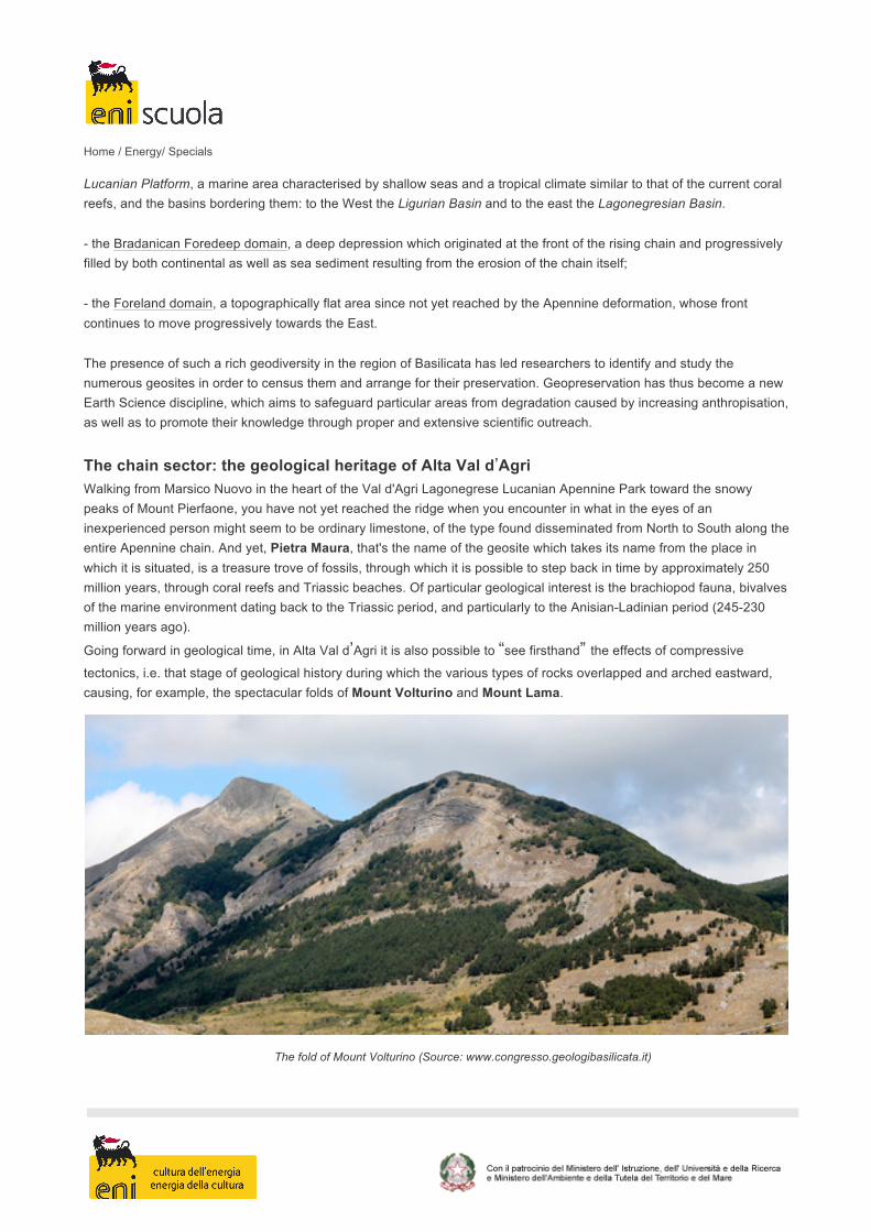
The chain sector: the geological heritage of Alta Val d’Agri Walking from Marsico Nuovo in the heart of the Val d'Agri Lagonegrese Lucanian Apennine Park toward the snowy peaks of Mount Pierfaone, you have not yet reached the ridge when you encounter in what in the eyes of an inexperienced person might seem to be ordinary limestone, of the type found disseminated from North to South along the entire Apennine chain. And yet, Pietra Maura, that's the name of the geosite which takes its name from the place in which it is situated, is a treasure trove of fossils, through which it is possible to step back in time by approximately 250 million years, through coral reefs and Triassic beaches. Of particular geological interest is the brachiopod fauna, bivalves of the marine environment dating back to the Triassic period, and particularly to the Anisian-Ladinian period (245-230 million years ago). Going forward in geological time, in Alta Val d’Agri it is also possible to “see firsthand” the effects of compressive
tectonics, i.e. that stage of geological history during which the various types of rocks overlapped and arched eastward, causing, for example, the spectacular folds of Mount Volturino and Mount Lama.
The fold of Mount Volturino (Source: www.congresso.geologibasilicata.it)
Home / Energy/ Specials
But the geological peculiarity of Alta Val d’Agri is definitely related to the presence of continental Europe's largest
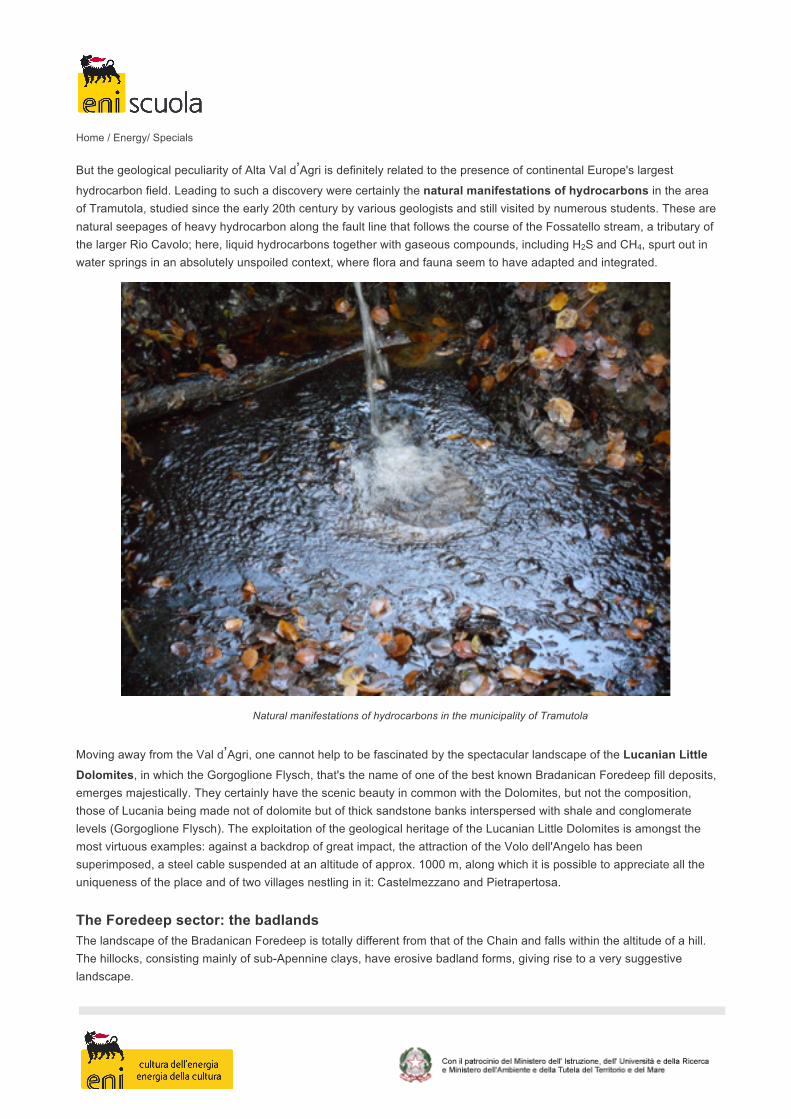
hydrocarbon field. Leading to such a discovery were certainly the natural manifestations of hydrocarbons in the area of Tramutola, studied since the early 20th century by various geologists and still visited by numerous students. These are natural seepages of heavy hydrocarbon along the fault line that follows the course of the Fossatello stream, a tributary of the larger Rio Cavolo; here, liquid hydrocarbons together with gaseous compounds, including H2S and CH4, spurt out in water springs in an absolutely unspoiled context, where flora and fauna seem to have adapted and integrated.
Natural manifestations of hydrocarbons in the municipality of Tramutola
Moving away from the Val d’Agri, one cannot help to be fascinated by the spectacular landscape of the Lucanian Little Dolomites, in which the Gorgoglione Flysch, that's the name of one of the best known Bradanican Foredeep fill deposits, emerges majestically. They certainly have the scenic beauty in common with the Dolomites, but not the composition, those of Lucania being made not of dolomite but of thick sandstone banks interspersed with shale and conglomerate levels (Gorgoglione Flysch). The exploitation of the geological heritage of the Lucanian Little Dolomites is amongst the most virtuous examples: against a backdrop of great impact, the attraction of the Volo dell'Angelo has been superimposed, a steel cable suspended at an altitude of approx. 1000 m, along which it is possible to appreciate all the uniqueness of the place and of two villages nestling in it: Castelmezzano and Pietrapertosa.
The Foredeep sector: the badlands The landscape of the Bradanican Foredeep is totally different from that of the Chain and falls within the altitude of a hill. The hillocks, consisting mainly of sub-Apennine clays, have erosive badland forms, giving rise to a very suggestive landscape.

Home / Energy/ Specials
Badlands, Basilicata
The badlands are forms of erosion due to meteoric waters which, on particularly erodible soils such as clay, inclined at an oblique angle to the slope and exposed to the South, produce a multiplicity of rivulets, and ridges in continuous and rapid change. At the base of the badland front one can often find rounded reliefs (mammellonari areas), adjacent to each other forming the transition zone towards the rounded reliefs, known as biancane. In the area of Aliano, which falls in the Basin of Sant'Arcangelo, the biancane often have a plant typical of the Mediterranean mastic on top called the lentisk (Pistacia lentiscus).
The Foreland area: Matera In the far eastern sector of the Basilicata region, near the border with Puglia, the geomorphological characteristics change once again and seem to be the prelude to the Puglia landscapes of the Gargano, Murgia and Salento. Here the carbonates of the Apulian Platform, coeval of the Appennine Platform but moved more eastward and separated from the latter by the Lagonegrese Basin, constitute the powerful backbone of the Matera Murgia. The city of Matera and especially the well-known old district of the Sassi, is excavated in a geological area of transition between the Bradanican Foreland and Foredeep, consisting of the presence of a type of rock, Gravina limestone, known locally as "limestone tufa".

Home / Energy/ Specials
The Sassi of Matera
And more… As if that were not enough, in addition there are two other geologically interesting areas:
- the volcanic complex of Mount Vulture, a volcano which developed between 130,000 and 700,000 years ago and now extinct; its geological significance is related to its "anomalous" position compared to the chain, given that all the other volcanic edifices of Central-Southern Italy are notoriously situated along the peri-Tyrrhenian strip. Particularly striking are the lakes of Monticchio, two twin volcanic lakes set in the volcanic caldera depression.
- the Pollino complex, situated on the Calabria-Lucania border, where it is possible to see emerging the ophiolitic
sequences of “Timpa delle Murge” and “Timpa di Pietrasasso”. These are fragments of oceanic crust that testify to the
existence of an ancient basin dating back some 200 million years and known in geology as Western or Alpine Tethys.
By Elisabetta Fortunato
Bibliography:
• Bentivenga, 2014. I geositi: non solo geologia, prospettive economiche e occupazionali. Proceedings of the
outreach day EconGEO “”. Geologia dell’Ambiente, Quarterly journal of SIGEA, Supplement no. 1/2015 ISNN

Home / Energy/ Specials
1591-5352.
• Bentivenga, 2011. Il Patrimonio Geologico: Una risorsa da proteggere e valorizzare. Proceedings of the
National Conference, Sasso di Castalda (PZ), 29 and 30 April. Suppl. no. 2, Geologia dell’Ambiente, 1-491.
• Bentivenga & Geremia, 2012. Geoheritage: Protecting and sharing. Proceeding and fieldtrip of the “7th
International Symposium ProGEO on the Conservation of the Geological Heritage”, 24-28 September, Bari,
Italy. Suppl. to no. 3/2012, Geologia dell’Ambiente, 1-257.
• Bentivenga & Palladino, 2013. Il patrimonio geologico dell’Alta Val d’Agri. In the proceedings of the 1st
Congress of Geologists of Basilicata, 30 November - 02 December 2013.
• Bianca M. & Caputo, 2003. Analisi morfotettonica ed evoluzione quaternaria della Val d’Agri, Appennino
Meridionale. Il Quaternario, Italian Journal of Quaternary Sciences 16(2) 158-170.
• Borraccini et al., 2002. 3D Model of the active extensional fault system of the high Agri River valley, Southern Apennines, Italy. In: Jessell, M. W. 2002 General Contributions. Journal of the Virtual Explorer, 6, 1-6.
• Carbone et al., 1991. Presentazione della Carta Geologica del Bacino del fiume Agri (Basilicata). Mem. Soc. Geol. It., 47, 129 - 143.
• Cello & Mazzoli, 1999. Apennine tectonics in southern Italy: a review. J. Geodyn., 27, 191–211.
• Cello et al., 2003. Active tectonics and earthquake sources in the epicentral area of the 1857 Basilicata earthquake (Southern Italy). J. Geodyn., 36, 37-50.
• Corrado, 2015. Alcuni geositi di interesse internazionale:strumenti per la diffusion della cultura geologica. In:
Proceedings of the outreach day EconGEO “I geositi: non solo geologia, prospettive economiche e
occupazionali”. Geologia dell’Ambiente, Quarterly journal of SIGEA, Supplement no. 1/2015 ISNN 1591-5352.
• Doglioni, 1991. A proposal modelling of W-dipping subduction possible application to the Tyrrhenian-Apennines system. Terra Nova, 3: 423-434.
• Doglioni et al., 1996. A geodynamic model of the Southern Apennines accretionary prisms. Terra Nova 8, 540–547.
• ISPRA (Istituto Superiore per la Protezione e la Ricerca Ambientale), 2010. Interazione tra strutture lineari e patrimonio geologico. Manuali e linee guida 65.1 /2010.
• Labella, 2015. Il Monte Vulture: osservazioni geologiche e paleontologiche. In: Proceedings of the outreach day
EconGEO “I geositi: non solo geologia, prospettive economiche e occupazionali”. Geologia dell’Ambiente,
Quarterly journal of SIGEA, Supplement no. 1/2015 ISNN 1591-5352.
Home / Energy/ Specials
• Malinverno & Ryan, 1986. Extension in the Tyrrhenian Sea and shortening in the Apennines as a result of arc migration driven by sinking of the lithosphere. Tectonics, 5: 227-245.
• Maschio et al., 2005. Active extension in Val d’Agri area, Southern Apennines, Italy: implications for the
geometry of the seismogenic belt. Geophys. J. Int. 162, 591–609.
• Mazzoli and Helman (1994). Neogene patterns of relative plate motion for Africa-Europe: some implications for recent Central Mediterranean tectonics. Geologische Rundschau, 83, 464-468.
• Patacca & Scandone, (1989). Post-Tortonian mountain building in the Apennines. The role of the passive sinking of a relic lithospheric slab. In: Boriani A., M. Bonafede M., Piccardo G.B., Vai G.B. Eds,. The lithosphere in Italy. Advances in Earth Science Research".
• Patacca E. & Scandone, 2007. Geology of the Southern Apennines. Boll. Soc. Geol. It. (Ital.J.Geosci.), Spec. Issue No. 7, pages 75-119. CROP-04 (ed. by A. Mazzotti, E. Patacca and P. Scandone).
• Prosser et al., 1996. Una sezione rappresentativa dell’Appennino Meridionale. Conference on Scientific
Research in Basilicata, Potenza, 29 February -1 March.
• Prosser, 2012. Introduzione alla geologia dell’Appennino meridionale. In: Proceedings of the 1st Congress of
the Order of Geologists of Basilicata. Potenza, 30 November - 2 December 2012.
• Shiner et al., 2004. Thin-skinned versus thick-skinned structural models for Apulian carbonate reservoirs:
constraints from the Val d’Agri Fields, S Apennines, Italy. Marine and Petroleum Geology, 805–827.
• Tropeano, 2003. Matera: una serie di geositi urbani o una città geosito? In: Proceedings of the conference: Preservation and Exploitation of the Geological Heritage, Rionero in Vulture (Potenza), 13 - 14 April 2002.