Embed Size (px)
Citation preview

1
Wetland Program Plan for Nebraska
By: Ted LaGrange, Wetland Program Manager Nebraska Game and Parks Commission P.O. Box 30370 Lincoln, NE 68503 (402) 471-5436 [email protected] OUTLINE
Table of Contents OVERALL GOAL AND TIME FRAME ................................................................................... 2 ACTION ITEM SUMMARY....................................................................................................... 3
Partnership Action Items............................................................................................................. 3 Monitoring and Assessment Action Items .................................................................................. 3 Regulation Action Items ............................................................................................................. 4 Voluntary Protection and Restoration Action Items ................................................................... 4 Wetland Management Action Items ........................................................................................... 6 Water Quality Standards Action Items ....................................................................................... 7 Outreach and Education Action Items ........................................................................................ 7 Information Needs Action Items ................................................................................................. 8
INTRODUCTION......................................................................................................................... 8 Wetland Definition...................................................................................................................... 9 Statewide Wetland Resources ..................................................................................................... 9 Wetland Classification .............................................................................................................. 10 Wetland Functions and Services ............................................................................................... 10 Threats and Stresses to Wetlands .............................................................................................. 11 Wetland Dynamics .................................................................................................................... 12
PARTNERSHIP APPROACH .................................................................................................. 13 Partnership Action Items........................................................................................................... 13
MONITORING AND ASSESSMENT ...................................................................................... 14 Monitoring and Assessment Action Items ................................................................................ 14
REGULATION ........................................................................................................................... 16 Regulation Action Items ........................................................................................................... 16
VOLUNTARY PROTECTION AND RESTORATION ......................................................... 16 Voluntary Protection and Restoration Action Items ................................................................. 17
WETLAND MANAGEMENT ................................................................................................... 19 Wetland Management Action Items ......................................................................................... 19
WATER QUALITY STANDARDS FOR WETLANDS ......................................................... 20

2
Water Quality Standards Action Items ..................................................................................... 21 OUTREACH AND EDUCATION ............................................................................................ 21
Outreach and Education Action Items ...................................................................................... 21 INFORMATION NEEDS .......................................................................................................... 22
Information Needs Action Items ............................................................................................... 22 REFERENCES ............................................................................................................................ 22
General ...................................................................................................................................... 22 Rainwater Basin and Other Playa Complexes .......................................................................... 29 Sandhills .................................................................................................................................... 36 Loup/Platte River Sandhills ...................................................................................................... 40 Eastern Saline............................................................................................................................ 40 Western Alkaline ...................................................................................................................... 42 Platte River................................................................................................................................ 43 Missouri River .......................................................................................................................... 46 Elkhorn River ............................................................................................................................ 49 Niobrara River .......................................................................................................................... 49
Appendix A- HGM Subclasses ................................................................................................... 51 Appendix B- NWI Priorities ...................................................................................................... 55 Appendix C- Restoration Practices ........................................................................................... 58 Appendix D- Wetland Management Information .................................................................... 64 Appendix E- Table of Information Needs ................................................................................. 72 OVERALL GOAL AND TIME FRAME The State of Nebraska plans to continue to implement its wetland program over the next three calendar years (2015-2017) with a goal of continuing to protect, restore, and manage wetlands. The State will use information from the Nebraska Wetland Condition Intensification Study to assess the condition of its wetlands (done in 2011-2013) to improve our understanding of baseline wetland conditions, and to prioritize wetland restoration and protection activities. Nebraska will continue to work in partnership with landowners, agencies, and organizations to restore and protect 9,000 acres of wetlands. The priorities for the restoration and protection will be determined by the Nebraska Game and Parks Commission and the local partners. We will also continue the stewardship and management of wetlands in state ownership. To have effective and efficient wetland restoration, protection, and management, we also emphasize that there is an important and ongoing need for improved information and outreach. The State will achieve our goal through implementing the activities identified in this plan. Note that this will be dependent upon obtaining needed funding and the required legislative and/or administrative approvals. An earlier draft of this plan was sent out for review to 89 individuals, representing 21 different organizations and agencies, including the Nebraska Department of Environmental Quality, the Nebraska Department of Natural Resources.

3
ACTION ITEM SUMMARY Partnership Action Items Objective: Work in a collaborative manner with at least 20 partner agencies and organizations to ensure that the goal is reached. Action: Continue to support the existing wetland conservation partnerships in Nebraska and form new partnerships where needed. Activities: The Nebraska Game and Parks Commission’s Wetland Program is involved to varying degrees in all of these partnerships and will continue to coordinate activities to ensure that wetland conservation is being delivered. In addition, numerous other individuals from the State of Nebraska are involved in these partnerships and will continue their involvement. Timeline: Ongoing. Monitoring and Assessment Action Items Objective: Increase our understanding of wetland conditions in at least 10 wetland complexes. Action: Complete the analysis of data from the monitoring of wetland indicators (level 1, 2, and 3) within 10 wetland complexes that was done in the 2011-2013 Nebraska Wetland Condition Intensification Study. As the analysis is completed, the final report and other publications will be prepared. Activities: This project was implemented by the University of Nebraska-Lincoln, administered by the Nebraska Game and Parks Commission, with input provided by a Core Team composed of 11 agencies and organizations, including the Nebraska Department of Environmental Quality. The UNL student is in the process of finalizing the data analysis and is working on his dissertation. Timeline: The project will be completed in 2015. Action: Use the information collected during the Nebraska Wetland Condition Intensification Study to finalize a rapid assessment method (RAM) for Nebraska’s wetlands. Activities: This project was implemented by the University of Nebraska-Lincoln, administered by the Nebraska Game and Parks Commission, with input provided by a Core Team composed of 11 agencies and organizations, including the Nebraska Department of Environmental Quality. The UNL student worked to develop the initial two versions of the RAM. The Core Team of partners will need to field test and finalize the RAM. Timeline: The project will be completed in 2016. Action: Fill in our numerous knowledge gaps about wetland conditions and functions. Activities: Implement the items listed in this plan’s Information Needs section.

4
Timeline: Ongoing. Action: Update Nebraska’s wetland inventory. Activities: Generate the most up-to-date GIS information to update the state’s wetland inventory data. Appendix B lists the wetland complexes in priority order for updates. Timeline: Ongoing. Action: Consider participation in the 2016 National Wetland Condition Assessment survey. Activities: Coordinate with the Nebraska Department of Environmental Quality and the University of Nebraska-Lincoln to determine how to best proceed. Timeline: 2016. Action: Set wetland priorities based on updated inventory and condition assessment information. Activities: Within each wetland complex, work with the local partnership to develop or refine priorities for wetland protection, restoration, and management. Timeline: Ongoing. Regulation Action Items Objective: Work in collaboration with agencies with wetland regulatory authority to ensure that there is no net loss of wetland acreage. Action: Nebraska plans to continue with its current set of wetland regulatory activities. Note that this is dependent upon decisions by the state Unicameral and the state regulatory agencies. Activities: These include Section 401 certification, State Programmatic General or Regional Permits, Nebraska statute Title 117, and the state’s Nongame and Endangered Species Act. Timeline: Ongoing. Action: Advocate for wetlands Activities: Nebraska will continue to play a role in advocating for the importance of wetlands by providing input into federal regulatory actions (e.g., Clean Water Act), federal policies (e.g., the Farm Bill), and local decision making (such as community planning). Timeline: Ongoing. Voluntary Protection and Restoration Action Items Objective: Work with our partners to protect and/or restore a minimum of 5,000 acres of wetlands. Action: Consider watershed planning, wildlife habitat, and other objectives when selecting restoration/ protection sites.

5
Activities: • Identify rare, vulnerable, or important wetlands and prioritize for
restoration/protection, this would include wetlands with rare plant or animal species and/or high quality plant communities. Most of this is being done by the local partnerships that were previously discussed.
• Apply tools (GIS, LiDAR, color-infrared photography, mapping, modeling, field inspection of soil, vegetation, and hydrologic conditions) to identify and prioritize restorable wetlands.
Timeline: Ongoing. Action: Provide clear guidance on appropriate wetland restoration and management techniques and success measures. Activities: Wetland restoration and management guides have been developed that are specific to Nebraska’s wetlands. These guides will be kept updated and shared with other partners as requested. An abbreviated version of these guides is provided in Appendix C and D. Timeline: Ongoing. Action: Establish and institutionalize long term protection, using mechanisms such as incentives, purchase of land title or easements to protect wetlands. Activities:
• Most wetland protection activities are determined by the local partnerships that were addressed earlier.
• The Nebraska Game and Parks Commission has a wetland acquisition program that is focused on additions to existing areas (roundouts), adding new large blocks of habitat that are easier to manage, and/or protecting the highest quality remaining wetlands.
• The Wetland Reserve Easements (WRE) program, administered by the Natural Resources Conservation Service, has been a very important program to protect and restore wetlands throughout Nebraska. The state will continue to partner with NRCS to deliver this program, and has hired a Biologist to help NRCS with management planning for WRE tracts.
Timeline: Ongoing. Action: Increase wetland acreage through restoration (re-establishment and rehabilitation). Activities:
• Wetlands will be restored on protected lands whenever possible. Much of this will be accomplished by existing local partnerships that have already been discussed.
• The Nebraska Game and Parks Commission will continue to offer its WILD Nebraska program that helps to restore wetlands on private lands.
• The partners will explore ways to better expedite the permitting process for restoring wetlands.

6
Timeline: Ongoing. Action: Develop a tracking system for wetland conservation activities. Activities:
• Develop and populate a tracking database for restoration/protection sites. This is being done by the partners for their respective programs.
• Annually obtain an update from the partners to summarize wetland protection accomplishments.
Timeline: Ongoing. Action: Monitor restoration/protection sites to ensure that they are implemented and managed correctly. Activities:
• Select a subset of indicators (core indicators) to monitor effectiveness of all restoration and protection sites.
• Monitor effectiveness of restoration/protection sites using core indicators. o Acres or percent of restored/protected wetlands monitored for > 3 years
using core indicators. o Acres or percent meeting established performance goals based on
function/condition indicators. o Update monitoring and performance records regularly.
• Based on ongoing monitoring efforts, information needs will be identified and actions will be taken to address these needs.
Timeline: Ongoing. Action: Modify restoration/protection techniques as needed. Activities: Based on the monitoring work, an adaptive management framework will be used to modify projects as needed. Timeline: Ongoing. Wetland Management Action Items Objective: Apply appropriate management actions yearly on at least 80% of the wetlands owned by the Nebraska Game and Parks Commission, and work with partners to improve management on at least 50% of their wetland acreage. Action: Identify management needs for wetlands owned by the Nebraska Game and Parks Commission. Activities: All of the state’s Wildlife Management Areas are being mapped to identify natural communities, including wetlands. These communities will be given a condition grade and then steps to improve the grade will be identified and implemented. Timeline: Completed in 2011 and will now be an ongoing activity.
7
Action: Continue to implement management activities on wetlands owned by the Nebraska Game and Parks Commission. Activities: Nebraska Game and Parks Commission land management staff will continue to identify needs and carry out management actions as necessary. Timeline: Ongoing. Action: Assist with the management of other publicly owned wetlands and privately owned wetlands as requested. Activities:
• The Nebraska Game and Parks Commission offers technical assistance to managers of other public and private lands. In addition, NGPC offers financial assistance to help with the management of privately owned wetlands.
• Continue to work with NRCS to implement management on properties enrolled in the Wetland Reserve Easements program.
Timeline: Ongoing. Action: Evaluate the effectiveness of management activities. Activity: Based on these evaluation efforts, information needs will be identified and actions will be taken to address these needs. Modify management activities as needed. Timeline: Ongoing. Water Quality Standards Action Items Objective: Work with the Nebraska Department of Environmental Quality to ensure that wetland water quality standards are maintained and not degraded. Action: Maintain the water quality standards that have been developed for Nebraska’s wetlands by the Nebraska Department of Environmental Quality. Activities: Assess the need to make wetland water quality standards revisions as part of the regular triennial review of the State's water quality standards. Timeline: Ongoing. Outreach and Education Action Items Objective: Ensure that materials are available to the public that provide information specific to Nebraska’s wetlands to help raise the awareness of the importance of wetlands and to help change attitudes and behaviors to help support conservation. Action: Continue to provide outreach materials to the public about wetlands. Activities:
• Maintain the Wetlands of Nebraska website (www.NebraskaWetlands.com). • Work with the Nebraska Game and Parks Commission’s Communications
Division staff to keep the public informed about wetland issues. • Assess the need to update the Guide to Nebraska’s Wetlands.

8
• Use social media outlets to help provide information about wetlands. • Continue the development of wetland apps.
Timeline: Ongoing. Action: Continue to provide support to NGPC and partner agency’s outdoor educators to teach students ranging from grade school through college about Nebraska’s wetland resources. Activities:
• Develop additional educational materials, such as the Wetlands of Nebraska video, for use by educators.
• Continue to lead field trips for students of all ages for hands-on wetland education.
• Deliver presentations to students in classroom settings as requested. Timeline: Ongoing. Information Needs Action Items Objective: Continue to improve the level of knowledge possessed by NGPC, local partnerships, and the scientific community about Nebraska’s wetlands. Action: Develop and maintain a wetland conservation information needs priority list for Nebraska. Activities: Work with the local partnerships and the scientific community to obtain input of information needs and priorities. Timeline: Ongoing. Action: Address the priority Information Needs. Activities: Work with the scientific community to secure funding to address the information needs. Timeline: Ongoing. INTRODUCTION Nebraska’s wetland resources are as diverse and dynamic as those of any state in the nation. They include marshes, lakes, reservoirs and ponds, river and stream backwaters, oxbows, wet meadows, playas, basins, fens, forested wetlands, and seep areas. These wetlands vary greatly in nature and appearance due to physical features such as geographic location, water source and permanence, and chemical properties. Some wetlands hold water for only a few weeks or less during the spring while others never go completely dry. Many wetlands receive their water from groundwater aquifers while others are totally dependent on precipitation and runoff. And finally, the water chemistry of wetlands ranges from fresh to saline, and from acidic to basic. These

9
descriptions identify the extremes of wetland characteristics. Nebraska’s wetland resources possess these extremes and virtually every combination in between. For detailed information about Nebraska’s wetlands, please see the Guide to Nebraska’s Wetlands and their Conservation Needs (LaGrange 2005) or visit the website www.NebraskaWetlands.com. Wetland Definition The State of Nebraska has adopted the federal definition that wetlands are “Those areas that are inundated or saturated by surface or groundwater at a frequency and duration sufficient to support, and that under normal circumstances do support, a prevalence of vegetation typically adapted for life in saturated soil conditions. Wetlands generally include swamps, marshes, bogs, and similar areas” (USACE 1987). Wetland delineation in Nebraska is currently based on the 1987 Corps of Engineers Wetlands Delineation Manual (USACE 1987) and the regional supplements for the Midwest and the Great Plains. The manual uses three diagnostic environmental characteristics to delineate wetlands. These are:
1) Vegetation - Defined by a prevalence of hydric plants adapted to growing in inundated or saturated conditions.
2) Hydric soils - The presence of soils that developed under inundated or saturated conditions that limit oxygen (anaerobic conditions).
3) Hydrology - Defined by inundation or saturation by water at some time during the growing season.
Statewide Wetland Resources At the time of statehood in 1867, Nebraska contained an estimated 2,910,000 acres of wetlands covering about 6% of the state (Dahl 1990). Through much of the state’s history, wetlands were viewed as an impediment to transportation, agriculture, and development. Wetlands have been impacted directly by filling, ditching, tiling, digging concentration pits, channelization, and declining water tables, and indirectly by changes in the surrounding uplands that caused increased sedimentation or the diversion of surface runoff away from wetlands. Wetlands and water areas were also created in some regions due to the construction of farm and livestock ponds, and locally rising water tables due to irrigation canal and reservoir seepage. However, the net result of all of these activities statewide was a reduction in wetlands by an estimated 35%, to 1,905,000 acres covering only 3.9% of the state (Dahl 1990). The destruction of wetlands was much higher in some regions of the state, but the statewide figure is buffered by the large wetland resource still remaining in the Sandhills. For example, approximately 90% of Rainwater Basin playa wetlands and 90% of the Eastern Saline Wetlands have been highly altered. Temporarily-flooded and seasonally-flooded wetlands were lost at the highest rate throughout the state, and much of this acreage

10
was not compensated for by the construction of lakes and ponds. Most states surrounding Nebraska have lost a greater percentage of their wetlands (Dahl 1990). Wetland Classification Numerous classification systems have been developed for wetlands. The one most commonly used today is the Cowardin system (Cowardin et al. 1979). This is a hierarchical system that classifies wetlands according to system, plant community and substrate, water regime, water chemistry, and numerous special modifiers such as the presence of dikes, drainage, and excavations. In many cases, portions of the same wetland can be classified differently using the Cowardin system. Systems - The three Cowardin wetland systems that occur in Nebraska are palustrine, lacustrine, and riverine. Palustrine systems are usually marshes and are dominated by vegetation. Lacustrine systems are lakes, reservoirs, and ponds usually deeper than 6.6 feet. Riverine systems are rivers and streams that flow in a defined channel. Water Regime - Water regime describes the duration and timing of inundation or saturation in a wetland. In Nebraska, most palustrine wetlands are of the temporarily, seasonally, or semi-permanently flooded water regime. Temporarily flooded wetlands contain water for only brief periods, often only a few weeks during the growing season. Seasonally flooded wetlands have water present for extended periods during the growing season, but they tend to dry up by the end of the season in most years. Semi-permanently flooded wetlands have water in them in most years and only occasionally dry up. The wetlands of Nebraska have been categorized into 14 different complexes (figure 1) that include playas, sandhill wetlands, saline and alkaline wetlands, and riverine wetlands (LaGrange 2005). The Guide to Nebraska’s Wetlands and their Conservation Needs (LaGrange 2005) provides a detailed description of each of these complexes. In addition, Nebraska’s wetlands have been classified by hydro-geomorphic (HGM) subclass (Jasmer et al. 1997) and their natural plant communities (Rolfsmeier and Steinauer 2010). Appendix A provides a list of the state’s HGM subclasses and their corresponding natural plant communities.
Wetland Functions and Services Our knowledge of how wetlands function has increased dramatically in the past few decades. Wetlands are now known to serve numerous functions or services, many of which have value to society as a whole. As wetland losses increased, the system that was dependent on these functions began to break down. Put another way, the loss of a small percentage of a region’s wetlands probably had little effect, but as losses increased, a threshold was crossed and negative impacts began to occur. Examples include declining wildlife diversity and abundance, increased flooding that has occurred in some watersheds, and deteriorating water quality that has become a problem in

11
many regions. This is why there is now a recognized need for wetlands conservation in Nebraska. Wetland Functions include:
• Improving Water Quality • Providing Habitat for Wildlife, Fish, and Unusual Plants • Reducing Flooding and Soil Erosion • Supplying Water, including Groundwater Recharge • Producing Food and Fiber • Providing Recreation and Education
It is important to note that not all wetlands serve all the functions listed above. Nor will a given wetland necessarily serve these functions equally within a year or over a series of years. Threats and Stresses to Wetlands
The primary existing threats and stresses to Nebraska’s wetlands are listed below:
1) Conversion to Other Uses - This threat exists especially for temporary and
seasonal wetlands that are easier to convert. Agricultural conversion and development for building sites, roads, feedlots, etc. are the primary conversion threats these areas face.
2) Alterations in the Watershed - Often not as obvious as direct impacts within the wetland itself, alterations within the watershed, or catchment area can be equally as damaging by disrupting the natural hydrology of the area. Concentration pits, terraces, diversions, stream channelization, ditches, etc. that either divert water away or stop water from reaching the wetland can have severe negative consequences for the area.
3) Culturally-accelerated Sedimentation - For wetlands located in watersheds dominated by row crops or urban development, culturally-accelerated sedimentation is a serious problem. This sediment alters the natural depths and hydro-periods of the wetlands and can also encourage the dominance of invasive plant species.
4) Invasive species – In addition to the woody species mentioned below, there are a number of other species that can be invasive in wetlands. These include reed canary grass, hybrid cattail, common reed, river bulrush, purple loosestrife, and salt cedar. These species can form dense monotypic stands that reduce habitat and wildlife diversity.
5) Woody Invasion - Historically, most of Nebraska’s wetlands were part of a prairie ecosystem and did not contain trees or shrubs with the exception being some riverine wetlands. In recent times, tree invasion has become a serious problem in wetlands, especially in the eastern two thirds of Nebraska. When left untreated for
12
a long period of time, managers will be forced to resort to more expensive tree removal methods to restore the wetland to an herbaceous community.
6) Extended Rest - Long-term rest has been a normal practice on public lands, and has occurred on many private wetlands where the owners do not use the area as a source of forage. Long-term rest from disturbance leads to loss of native plant diversity along with increased abundance and invasion by non-native and aggressive wetland plant species. River bulrush, cattail, and reed canary grass are especially adept at out-competing other vegetation and establishing a monoculture in wetlands lacking management.
7) Fragmentation - Fragmentation of wetlands by crop fields, roads, fences, berms, or other factors increases edge effect. This usually leads to increased and more rapid invasion by non-native and aggressive species, loss of genetic diversity, and degradation of wildlife habitat.
8) Repetitive Management - Conducting the same management action every year at the same time can also lead to a reduction of plant diversity and invasion of non-natives. Using a variety of techniques and applying them at different times of the year will increase diversity.
9) Lack of Grazing Management - Poor grazing management (either too little or too much intensity) has impacted many of Nebraska’s wetlands leading to loss of native plant diversity and abundance, invasion by non-native species, and uniform vegetative structure. In some wetlands, periodic, intensive heavy grazing can produce positive results for wetlands depending on the goals and objectives. Some wetland complexes in the state, such as the Rainwater Basin and the Southwest Playas provide critical migratory habitat for many species of water birds. The migratory species that use these wetlands benefit from a strategy of heavy grazing since it provides open water, bare shorelines, and early succession vegetation. Periodic intensive heavy grazing should be followed by periods of rest to enable plant regrowth, if that is the desired objective. In other wetlands, a lighter grazing prescription may be needed.
Wetland Dynamics Nebraska’s pre-settlement wetlands were highly adapted to disturbance. They were frequently burned by prairie fires, grazed by both large (e.g., bison and elk) and small herbivores (e.g., muskrats), and endured droughts and flooding. Periodic disturbance is essential to maintain and enhance wetland quality, plant and animal communities, and ecosystem processes. Natural disturbances operate at a variety of scales, intensities, and duration. Climate operates at a large scale, fire and grazing at intermediate scales, and insect herbivory and numerous other factors at small scales. Interaction of disturbances, for example, flooding and grazing, increase the range of patch types within wetlands resulting in more complex systems of species composition and structure. In pre-settlement Nebraska, the disturbance regimes occurred within a large landscape. Now, most wetlands are managed within a fragmented landscape with a limited

13
disturbance regime applied on regular intervals. This has resulted in much simpler systems. A primary goal of wetland management (described in a later section in this plan) is to mimic the natural disturbance regimes to the greatest extent possible. Wetland restoration and protection actions should also consider the importance of the role that these disturbance regimes play. Circumstances in today’s world often have reduced natural disturbances. For example, a wetland may be located near a housing subdivision making prescribed burning a challenge, or a small wetland may not have the infrastructure such as fencing or livestock water facilities needed for grazing. In addition, specific management challenges may require alteration of the natural disturbance regime. For example, control of the invasive reed canary grass in a wetland may require several consecutive years of early spring fire followed by intense spring grazing to reduce the reed canary grass. Or, a dense stand of reed canary grass in a wetland may need several passes with a disk followed by an herbicide application. Wetland Program Plan Components PARTNERSHIP APPROACH Nebraska has long recognized that implementing wetland conservation is complex and is best accomplished by working in partnerships among landowners, agencies, and organizations. Partnerships play a very foundational role in the other core elements of Nebraska’s wetland program. Some examples of partnerships that are working to implement wetland conservation in Nebraska include the Nebraska Natural Legacy Project (our state’s Wildlife Action Plan), Rainwater Basin Joint Venture, Playa Lakes Joint Venture, Upper Mississippi River/Great Lakes Joint Venture, Landscape Conservation Cooperatives, Saline Wetlands Conservation Partnership, Sandhills Task Force, Missouri River Ecosystem Coordination Group, and the Platte River Recovery Implementation Program. The structure of each of these partnerships differs, but most have governing boards and implementation plans. Collectively, these partnerships have secured over $100 million in competitive grant funding for wetland conservation in Nebraska since 1994, and benefited well over 90,000 acres. Partnership Action Items Objective: Work in a collaborative manner with at least 20 partner agencies and organizations to ensure that the goal is reached. Action: Continue to support the existing wetland conservation partnerships in Nebraska and form new partnerships where needed. Activities: The Nebraska Game and Parks Commission’s Wetland Program is involved to varying degrees in all of these partnerships and will continue to coordinate activities to ensure that wetland conservation is being delivered. In addition, numerous other

14
individuals from the State of Nebraska are involved in these partnerships and will continue their involvement. Timeline: Ongoing. MONITORING AND ASSESSMENT
A monitoring and assessment program is defined as the establishment and operation of appropriate devices, methods, systems and procedures necessary to monitor, compile, and analyze data on the condition of wetlands (adapted from Elements of a State Water Monitoring and Assessment Program, March 2003). Monitoring is the systematic observation and recording of current and changing conditions, while assessment is the use of that data to evaluate or appraise wetlands to support decision-making and planning processes. Wetlands can be characterized both by their condition and functions. Wetland condition is the current state as compared to reference standards for physical, chemical, and biological characteristics, while functions represent the processes that characterize wetland ecosystems.
EPA refers to a three-tier framework for wetlands monitoring and assessment.
Level 1(landscape assessments) rely entirely on GIS data, using landscape disturbance indices to assess wetland condition. This approach involves characterizing the lands that surround wetlands through the use of landscape metrics (e.g., percent forest cover and land use category). Assessment results can provide a coarse gauge of wetland condition within a watershed. Level 2 (rapid assessments) use relatively simple metrics to assess wetland condition. They are customarily based on the readily observable hydro-geomorphic and plant community attributes of wetlands. They also can employ the use of a "stressor checklist." Rapid assessment methods typically produce a single score that describes where a wetland generally falls along a gradient of human disturbance and with respect to ecological integrity. Level 3 (intensive site assessments) provide a more thorough and rigorous measure of wetland condition by gathering direct and detailed measurements of biological taxa and/or hydro-geomorphic functions.
Well designed and executed wetland monitoring and assessment programs are a critical tool to better manage and protect wetland resources. They allow establishment of a baseline in wetland extent, condition and function, to detect change, to assess value, and to characterize trends over time. Monitoring and assessment plays a foundational role in the other core elements of wetlands programs. Monitoring and assessment can also inform planning and prioritization at both the individual wetland and watershed scales.
Monitoring and Assessment Action Items

15
Objective: Increase our understanding of wetland conditions in at least 10 wetland complexes. Action: Complete the analysis of data from the monitoring of wetland indicators (level 1, 2, and 3) within 10 wetland complexes that was done in the 2011-2013 Nebraska Wetland Condition Intensification Study. As the analysis is completed, the final report and other publications will be prepared. Activities: This project was implemented by the University of Nebraska-Lincoln, administered by the Nebraska Game and Parks Commission, with input provided by a Core Team composed of 11 agencies and organizations, including the Nebraska Department of Environmental Quality. The UNL student is in the process of finalizing the data analysis and is working on his dissertation. Timeline: The project will be completed in 2015. Action: Use the information collected during the Nebraska Wetland Condition Intensification Study to finalize a rapid assessment method (RAM) for Nebraska’s wetlands. Activities: This project was implemented by the University of Nebraska-Lincoln, administered by the Nebraska Game and Parks Commission, with input provided by a Core Team composed of 11 agencies and organizations, including the Nebraska Department of Environmental Quality. The UNL student worked to develop the initial two versions of the RAM. The Core Team of partners will need to field test and finalize the RAM. Timeline: The project will be completed in 2016. Action: Fill in our numerous knowledge gaps about wetland conditions and functions. Activities: Implement the items listed in this plan’s Information Needs section. Timeline: Ongoing. Action: Update Nebraska’s wetland inventory. Activities: Generate the most up-to-date GIS information to update the state’s wetland inventory data. Appendix B lists the wetland complexes in priority order for updates. Timeline: Ongoing. Action: Consider participation in the 2016 National Wetland Condition Assessment survey. Activities: Coordinate with the Nebraska Department of Environmental Quality and the University of Nebraska-Lincoln to determine how to best proceed. Timeline: 2016. Action: Set wetland priorities based on updated inventory and condition assessment information. Activities: Within each wetland complex, work with the local partnership to develop or refine priorities for wetland protection, restoration, and management.
16
Timeline: Ongoing. REGULATION
Wetland regulatory and permit programs in general consist of a few basic elements: a jurisdictional scope, a method to authorize impacts to aquatic resources and assess proposed authorizations, and a method of assuring compliance. State and tribal wetland and aquatic resource regulatory programs are defined by the authority under which they operate (i.e., Clean Water Act (CWA) §404, CWA §401, Nebraska Title 117) and how the program is implemented.
The State of Nebraska considers wetlands, including geographically isolated wetlands, to be waters of the state. Beneficial uses of wetlands are listed by the Nebraska Department of Environmental Quality and these uses are protected from degradation.
Regulation Action Items Objective: Work in collaboration with agencies with wetland regulatory authority to ensure that there is no net loss of wetland acreage. Action: Nebraska plans to continue with its current set of wetland regulatory activities. Note that this is dependent upon decisions by the state Unicameral and the state regulatory agencies. Activities: These include Section 401 certification, State Programmatic General or Regional Permits, Nebraska statute Title 117, and the state’s Nongame and Endangered Species Act. Timeline: Ongoing. Action: Advocate for wetlands Activities: Nebraska will continue to play a role in advocating for the importance of wetlands by providing input into federal regulatory actions (e.g., Clean Water Act), federal policies (e.g., the Farm Bill), and local decision making (such as community planning). Timeline: Ongoing. VOLUNTARY PROTECTION AND RESTORATION
Wetland protection is defined as removing a threat or preventing the decline of wetland conditions (US EPA, 2007).
Wetland restoration is the manipulation of a former or degraded wetland's physical, chemical, or biological characteristics to return its natural functions. Restoration practices include:
• Re-establishment- the rebuilding a of former wetland; and

17
• Rehabilitation- repairing the functions of a degraded wetland (US EPA, 2007).
Wetland restoration and management projects are often complex and require expertise in biology, engineering, hydrology, and soils. Because of this, wetland projects will be designed by an interdisciplinary team (bio-engineering team) possessing the necessary expertise (biology, engineering, hydrology, and soils). Wetland restoration projects often will include collaborating with our numerous partners. This partnering is highly encouraged. Some programs, such as the Wetland Reserve Easements program, and Partners for Fish and Wildlife Program can provide essential funding for project completion. Details about implementing wetland restoration projects are available from the various partners involved. The Nebraska Game and Parks Commission has developed a manual to help guide wetland restoration projects, and this manual is available upon request. Some of the detailed practices covered in the manual are provided in Appendix C. Voluntary Protection and Restoration Action Items Objective: Work with our partners to protect and/or restore a minimum of 5,000 acres of wetlands. Action: Consider watershed planning, wildlife habitat, and other objectives when selecting restoration/ protection sites. Activities:
• Identify rare, vulnerable, or important wetlands and prioritize for restoration/protection, this would include wetlands with rare plant or animal species and/or high quality plant communities. Most of this is being done by the local partnerships that were previously discussed.
• Apply tools (GIS, LiDAR, color-infrared photography, mapping, modeling, field inspection of soil, vegetation, and hydrologic conditions) to identify and prioritize restorable wetlands.
Timeline: Ongoing. Action: Provide clear guidance on appropriate wetland restoration and management techniques and success measures. Activities: Wetland restoration and management guides have been developed that are specific to Nebraska’s wetlands. These guides will be kept updated and shared with other partners as requested. An abbreviated version of these guides is provided in Appendix C and D. Timeline: Ongoing. Action: Establish and institutionalize long term protection, using mechanisms such as incentives, purchase of land title or easements to protect wetlands.

18
Activities: • Most wetland protection activities are determined by the local partnerships that
were addressed earlier. • The Nebraska Game and Parks Commission has a wetland acquisition program
that is focused on additions to existing areas (roundouts), adding new large blocks of habitat that are easier to manage, and/or protecting the highest quality remaining wetlands.
• The Wetland Reserve Easements (WRE) program, administered by the Natural Resources Conservation Service, has been a very important program to protect and restore wetlands throughout Nebraska. The state will continue to partner with NRCS to deliver this program, and has hired a Biologist to help NRCS with management planning for WRE tracts.
Timeline: Ongoing. Action: Increase wetland acreage through restoration (re-establishment and rehabilitation). Activities:
• Wetlands will be restored on protected lands whenever possible. Much of this will be accomplished by existing local partnerships that have already been discussed.
• The Nebraska Game and Parks Commission will continue to offer its WILD Nebraska program that helps to restore wetlands on private lands.
• The partners will explore ways to better expedite the permitting process for restoring wetlands.
Timeline: Ongoing. Action: Develop a tracking system for wetland conservation activities. Activities:
• Develop and populate a tracking database for restoration/protection sites. This is being done by the partners for their respective programs.
• Annually obtain an update from the partners to summarize wetland protection accomplishments.
Timeline: Ongoing. Action: Monitor restoration/protection sites to ensure that they are implemented and managed correctly. Activities:
• Select a subset of indicators (core indicators) to monitor effectiveness of all restoration and protection sites.
• Monitor effectiveness of restoration/protection sites using core indicators. o Acres or percent of restored/protected wetlands monitored for > 3 years
using core indicators. o Acres or percent meeting established performance goals based on
function/condition indicators.

19
o Update monitoring and performance records regularly. • Based on ongoing monitoring efforts, information needs will be identified and
actions will be taken to address these needs.
Timeline: Ongoing. Action: Modify restoration/protection techniques as needed. Activities: Based on the monitoring work, an adaptive management framework will be used to modify projects as needed. Timeline: Ongoing. WETLAND MANAGEMENT The protection and restoration of wetlands is not adequate to maintain their full suite of natural functions. Management actions are a critical component in the overall conservation of Nebraska’s wetlands. The following information is adapted from a document developed by the Nebraska Game and Parks Commission for use on Wildlife Management Areas. The document should be consulted for detailed information. Some of the detailed information from the document is provided in Appendix D. These management techniques are applicable to both public and private lands. Examples of prescribed management techniques discussed include grazing, prescribed burning, haying/shredding/mowing, herbicide application, mechanical (e.g., disking), water-level manipulation, and tree removal. Usually, there is usually not one “magic bullet” treatment that can be applied just one time to accomplish objectives. Multiple management activities usually need to be prescribed to obtain the desired effect. Management should be prescribed based upon site conditions and biological justification. Prior to undertaking wetland management, the need for wetland restoration should be assessed both within the wetland and for the entire watershed. Although the project area may be only on a part of the wetland, it needs to be remembered that the wetland is being impacted by alterations in the entire watershed. Addressing the watershed alterations may require different tools (e.g., private lands programs). For details about restoration, please see the Voluntary Protection and Restoration Section of this document. Wetland Management Action Items Objective: Apply appropriate management actions yearly on at least 80% of the wetlands owned by the Nebraska Game and Parks Commission, and work with partners to improve management on at least 50% of their wetland acreage. Action: Identify management needs for wetlands owned by the Nebraska Game and Parks Commission.

20
Activities: All of the state’s Wildlife Management Areas are being mapped to identify natural communities, including wetlands. These communities will be given a condition grade and then steps to improve the grade will be identified and implemented. Timeline: Completed in 2011 and will now be an ongoing activity. Action: Continue to implement management activities on wetlands owned by the Nebraska Game and Parks Commission. Activities: Nebraska Game and Parks Commission land management staff will continue to identify needs and carry out management actions as necessary. Timeline: Ongoing. Action: Assist with the management of other publicly owned wetlands and privately owned wetlands as requested. Activities:
• The Nebraska Game and Parks Commission offers technical assistance to managers of other public and private lands. In addition, NGPC offers financial assistance to help with the management of privately owned wetlands.
• Continue to work with NRCS to implement management on properties enrolled in the Wetland Reserve Easements program.
Timeline: Ongoing. Action: Evaluate the effectiveness of management activities. Activity: Based on these evaluation efforts, information needs will be identified and actions will be taken to address these needs. Modify management activities as needed. Timeline: Ongoing. WATER QUALITY STANDARDS FOR WETLANDS
Water quality standards are the foundation of the water quality-based pollution control program mandated by the Clean Water Act (CWA). They define the goals for a water body by designating its highest attainable uses, setting criteria that reflect the current and evolving body of scientific information to protect those uses, and establishing provisions to protect water bodies from further degradation. Federal regulations (40 CFR part 230.3) implementing the CWA include wetlands as "waters of the U.S." and therefore require water quality standards. Water quality standards developed specifically for wetlands help ensure that the provisions of the Clean Water Act, which apply to all surface waters, are consistently applied to wetlands; they also provide a more relevant scientific basis for applying these provisions. Water quality standards (WQS) regulations at 40 CFR Parts 131 and 132 provide specific requirements for development of state and tribal standards including specifying appropriate water uses to be achieved and protected, providing appropriate criteria to support those uses, and applying anti-degradation policy to all waters, including wetlands. The regulation also provides states and tribes with the flexibility to adopt sub-categories of uses and associated criteria to allow for differentiation between types of wetlands, their expected uses, functions and condition.

21
The State of Nebraska considers wetlands, including geographically isolated wetlands, to be waters of the state. The Nebraska Department of Environmental Quality has developed water quality standards for wetlands.
Water Quality Standards Action Items Objective: Work with the Nebraska Department of Environmental Quality to ensure that wetland water quality standards are maintained and not degraded. Action: Maintain the water quality standards that have been developed for Nebraska’s wetlands by the Nebraska Department of Environmental Quality. Activities: Assess the need to make wetland water quality standards revisions as part of the regular triennial review of the State's water quality standards. Timeline: Ongoing. OUTREACH AND EDUCATION There is an ongoing need and demand from the general public, schools, conservation partners, and community organizations for education and outreach materials specifically relating to Nebraska’s wetland resources. Outreach and Education Action Items Objective: Ensure that materials are available to the public that provide information specific to Nebraska’s wetlands to help raise the awareness of the importance of wetlands and to help change attitudes and behaviors to help support conservation. Action: Continue to provide outreach materials to the public about wetlands. Activities:
• Maintain the Wetlands of Nebraska website (www.NebraskaWetlands.com). • Work with the Nebraska Game and Parks Commission’s Communications
Division staff to keep the public informed about wetland issues. • Assess the need to update the Guide to Nebraska’s Wetlands. • Use social media outlets to help provide information about wetlands. • Continue the development of wetland apps.
Timeline: Ongoing. Action: Continue to provide support to NGPC and partner agency’s outdoor educators to teach students ranging from grade school through college about Nebraska’s wetland resources. Activities:
• Develop additional educational materials, such as the Wetlands of Nebraska video, for use by educators.

22
• Continue to lead field trips for students of all ages for hands-on wetland education.
• Deliver presentations to students in classroom settings as requested. Timeline: Ongoing. INFORMATION NEEDS Wetland conservation is a complex undertaking and there are many uncertainties that should be addressed to help improve our efforts. Broadly, we need better information on how wetlands function and how to best restore and protect wetlands. An itemized list of information needs is provided in Appendix E. This list is not all inclusive and is subject to change as we become aware of gaps in our knowledge base. Information Needs Action Items Objective: Continue to improve the level of knowledge possessed by NGPC, local partnerships, and the scientific community about Nebraska’s wetlands. Action: Develop and maintain a wetland conservation information needs priority list for Nebraska. Activities: Work with the local partnerships and the scientific community to obtain input of information needs and priorities. Timeline: Ongoing. Action: Address the priority Information Needs. Activities: Work with the scientific community to secure funding to address the information needs. Timeline: Ongoing. REFERENCES General Austin, J.E., and A.L. Richert. 2001. A Comprehensive Review of Observational and
Site Evaluation Data of Migrant Whooping Cranes in the United States, 1943-99. U.S. Geological Survey Report, Northern Prairie Wildlife Research Center, Jamestown, ND. 156 pp.
Bellrose, F.C. 1980. Ducks, Geese, and Swans of North America. Stackpole Books,
Harrisburg, Pa., 540 p. Berry, C.R. Jr. and D.G. Buechler. 1993. Wetlands in the Northern Great Plains, A
Guide to Values and Management. U.S. Fish and Wildlife Service and Agricultural Extension Service, S. D. State University, 13 pp.

23
Brown, S., C. Hickey, B. Harrington, and R. Gill, eds. 2001. The U.S. Shorebird
Conservation Plan, 2nd ed. Manomet Center for Conservation Sciences, Manomet, MA. 60 pp.
Collins, J.T. 1993. Amphibians and Reptiles in Kansas, 3rd edition, revised. University
of Kansas, Natural History Museum, Lawrence. 397 pp. (Contains information for most of the species of amphibians and reptiles found in Nebraska).
Cowardin, L.M., V .Carter, F Golet and E. LaRoe. 1979. Classification of Wetlands and
Deepwater Habitats of the United States. FWS/OBS-79/31. U.S. Department of the Interior, Fish and Wildlife Service, Washington D.C. 131 pp.
Cross, D. 1994. Waterfowl Management Handbook. U.S. Fish and Wildlife Service.
Leaflet 13. Dahl, T.E. 1990. Wetlands – Losses in the United States - 1780’s to 1980’s. U.S.
Department of the Interior, Fish and Wildlife Service, Washington, D.C. 21 pp. Dahl, T.E. and C.E. Johnson. 1991. Status and Trends of Wetlands in the Conterminous
United States. Mid-1970s to Mid-1980s. First Update of the National Wetlands Status Report. U.S. Department of the Interior, Fish and Wildlife Service, Washington D.C. 28 pp.
Dahl, T.E. 2000. Status and Trends of Wetlands in the Conterminous United States
1986 to 1997. U.S. Department of the Interior, Fish and Wildlife Service, Washington D.C. 82 pp.
Ducks Unlimited. 1999. Nebraska Conservation Plan- A Strategy for Restoring and
Protecting Nebraska’s Wetland Resources. Ducks Unlimited’s Northern Great Plains Office, Bismarck, ND. 31 pp.
Elliott, C R. 1991. Mapping Nebraska Wetlands. NEBRASKAland. June. Nebraska
Game and Parks Commission. pp. 36-41. Farrar, J. 1976. Dabblers and Divers, Nebraska’s Ducks. NEBRASKAland. Nov.
Nebraska Game and Parks Commission. pp. 24-33. Farrar, J. 1983. Nebraska Rivers - Special Issue. NEBRASKAland. Jan. Nebraska
Game and Parks Commission. Farrar, J. 1983. Ducks and the 404. NEBRASKAland. Sept. Nebraska Game and Parks
Commission. pp. 42-43. Farrar, J. 1985. Birds of the Marsh. NEBRASKAland. Jan. Nebraska Game and Parks
Commission. pp. 28-41.

24
Farrar, J. 1989. Blueprint for Waterfowl. NEBRASKAland. Aug. Nebraska Game and
Parks Commission. pp. 26-35. Farrar, J. 1990. Field Guide to Wildflowers of Nebraska and the Great Plains.
NEBRASKAland. Nebraska Game and Parks Commission, 215 pp. Farrar, J. 1991. Marsh Birds. NEBRASKAland. May. Nebraska Game and Parks
Commission. pp. 8-21. Farrar, J. 1992. Musquash...Grazer of the Marsh. NEBRASKAland. June. Nebraska
Game and Parks Commission. pp. 14-23. Farrar, J. 1998. A wetland reborn. NEBRASKAland. Mar. Nebraska Game and Parks
Commission. pp 28-35. Farrar, J. 1998. A haven for herons (Omaha’s urban wetland). NEBRASKAland. Oct.
Nebraska Game and Parks Commission. pp 40-45. Farrar, J. 2000. Burning for wildlife. NEBRASKAland. Mar. Nebraska Game and Parks
Commission. pp. 20-25. Farrar, J. 2004. Birding Nebraska. NEBRASKAland. Jan-Feb. Nebraska Game and
Parks Commission. 178 pp. Forsberg, M. 1997. Purple loosestrife, the rising tide. NEBRASKAland. July. Nebraska
Game and Parks Commission. pp. 26-33. Frankforter, J.D. 1996. Nebraska wetland resources. Pp. 261-66 in Fretwell, J.D., J.S.
Williams, and P.J. Redman (eds.). National Water Summary of Wetland Resources, U.S. Geological Survey Water Supply Paper 2425.
Galatowitsch, S.M. and A. van der Valk. 1994. Restoring Prairie Wetlands: An
Ecological Approach. Iowa State University Press. 246 pp. Gersib, R.A. 1991. Nebraska Wetlands Priority Plan. Nebraska Game and Parks
Commission. 35 pp. Gersib, R.A. 1985. Wetlands Not Wastelands. NEBRASKAland. Sept. Nebraska Game
and Parks Commission. pp. 20-25. Great Plains Research. 1998. Freshwater functions and values of prairie wetlands-
Special Issue. Great Plains Research 8(1). 208 pp.

25
Harmon, K. 1980. Economics of Wetlands. NEBRASKAland. Oct. Nebraska Game and Parks Commission. pp. 18-19.
Hubbard, D. E. 1989. Wetland Values in the Prairie Pothole Region of Minnesota and
the Dakotas. Biological Report 88(43), Brookings, SD: U.S. Fish and Wildlife Service, Cooperative Research Unit.
Johnsgard, P.A. 2001. The Nature of Nebraska: Ecology and Biodiversity. University
of Nebraska Press, Lincoln. 402 pp. Johnsgard, P.A. 2012. Nebraska’s Wetlands: Their Wildlife and Ecology. University of
Nebraska-Lincoln, Nebraska Water Survey Paper No. 78. Lincoln. Jones, J.K., Jr., D.M. Armstrong, R.S. Hoffman, and C. Jones. 1983. Mammals of the
Northern Great Plains. 1983. University of Nebraska Press, Lincoln. 379 pp. Kaul, R.B. 1975. Vegetation of Nebraska (circa 1850). Univ. of Nebraska- Lincoln,
Conservation and Survey Division. Map. Knue, J. 1997. NEBRASKAland Magazine Wildlife Viewing Guide. Jan-Feb.
Nebraska Game and Parks Commission. 96 pp. Kushlan, J. A., et al. 2002. Waterbird Conservation for the Americas: The North
American Waterbird Conservation Plan, Version 1. U.S. Fish and Wildlife Service, Washington, D.C. 78 pp.
Kusler, J.A. and M.E. Kentula. 1990. Wetland Creation and Restoration: The Status of
the Science. Island Press, Washington D.C. 594 pp. Kusler, J.A. and T. Opheim. 1996. Our National Wetland Heritage, a Protection Guide.
Environmental Law Inst., Washington, D.C. 149 pp. Kuzelka, R.D., project manager. C.A. Flowerday, editor. R.N. Manley, contributing
editor/consulting historian and B.C. Rundquist, editorial associate. 1993. Flat Water: A History of Nebraska and Its Water. University of Nebraska, Lincoln. Conservation and Survey Division. Resource Report no. 12. 291 pp.
LaGrange, T.G. 1996. The purple problem (purple loosestrife). NEBRASKAland. June.
Nebraska Game and Parks Commission. pp. 6-7. LaGrange, T.G. 2005. A Guide to Nebraska’s Wetlands and Their Conservation
Needs. Second Edition. Nebraska Game and Parks Commission, Lincoln, Neb. 59 pp.

26
LaGrange, T.G., S. Thomas, and R. Stutheit. 2004. The geographic definitions of Nebraska’s Wetland Complexes and statistics for each generated from digital National Wetland Inventory data. Nebraska Game and Parks Commission, Lincoln. Draft.
Larson, G.E. 1993. Aquatic and Wetland Vascular Plants for the Northern Great Plains.
U.S. Department of Agriculture, Forest Service, Rocky Mountain Forest and Range Experiment Station. Gen. Tech. Rep. RM-238, Fort Collins, Colo. Oct. 681 pp.
Leitch, J. A. and B. Hovde. 1996. Empirical valuation of prairie potholes: Five case
studies. Great Plains Research 6:25-39.
Maher, H.D., Jr., G.F. Engelmann, and R.D. Shuster. 2003. Roadside Geology of Nebraska. Mountain Press Publ. Co., Missoula, MT. 264 pp.
McMurtrey, M.D., R. Craig and G. Schildman. 1972. Nebraska Wetland Survey. Habitat
Work Plan K-71. Nebraska Game and Parks Commission. 78 pp. Mitsch, W.J. and J.G. Gosselink. 2000. 3rd edition. Wetlands. Van Nostrand Reinhold,
936 pp. Middleton, B. 1999. Wetland Restoration, Flood Pulsing, and Disturbance Dynamics.
John Wiley & Sons Inc., New York. 388 pp. Mollhoff, W.J. 2001. The Nebraska Breeding Bird Atlas, 1984-89. Nebraska
Ornithologist’s Union Occasional Papers No. 7. Nebraska Game and Parks Commission, Lincoln. 233 pp.
Moshiri, G. 1994. Constructed Wetlands for Water Quality Improvement. Lewis
Publishers, Boca Raton. 656 pp. Murkin, H.R., A.G. van der Valk, and W.R. Clark. 2000. Prairie Wetland Ecology, the
Contribution of the Marsh Ecology Research Program. Iowa State University Press, Ames. 413 pp.
National Research Council. 1995. Wetlands: Characteristics and Boundaries. Natl.
Academy Press, Washington, D.C. 307 pp. Nebraska Department of Environmental Quality, Nebraska Game and Parks
Commission, and the Nebraska Natural Resources Commission. 1997. Nebraska Wetland Resources: A Summary of the Issues Involving Conservation of Nebraska’s Wetlands. 87 pp.
Nebraska Department of Agriculture. 2000. Purple Loosestrife Pamphlet. Lincoln.

27
Payne, N.F. 1992. Techniques for Wildlife Habitat Management of Wetlands. McGraw
Hill, Inc. 549 pp.
Pennak, R.W. 1978. Fresh-water Invertebrates of the United States. John Wiley and Sons, N. Y. 803 pp.
Rolfsmeier, S.B., and G. Steinauer. 2010. Terrestrial Ecological Systems and Natural
Communities of Nebraska. Version IV. Nebraska Game and Parks Commission. 223 pp.
Rundquist, D. 1987. Wetlands: A Different Point of View. NEBRASKAland. April.
Nebraska Game and Parks Commission. pp. 10-15. Schmidt, T.L., and T.D. Wardle. 1998. The Forest Resources of Nebraska. Research
Paper NC-332, North Central Research Station, U.S. Forest Service, St. Paul, MN. 114 pp.
Schneider, R., K. Stoner, G. Steinauer, M. Panella, and M. Humpert. 2011. The
Nebraska Natural Legacy Project: State Wildlife Action Plan. 2nd ed. Nebraska Game and Parks Commission, Lincoln. 344 pp.
Sharpe, R.S., W.R. Silcock, and J.G. Jorgensen. 2001. Birds of Nebraska: Their
Distribution and Temporal Occurrence. University of Nebraska Press, Lincoln. 520 pp.
Slattery, B.E. and A.S. Kesselheim. 1995. WOW!. The Wonders of Wetlands, an
Educator’s Guide. Environ. Concern. St. Michaels, Md. 331 pp. Smith, L.M. 2003. Playas of the Great Plains. University of Texas Press, Austin. 257
pp. Smith, L.M., D. Haukos, S. McMurry, T. LaGrange, and D. Willis. 2011. Ecosystem
services provided by playa wetlands in the High Plains: Potential influences of USDA conservation programs and practices. Ecological Applications 21:S82-S92. doi:10.1890/09-1133.1.
Steinauer, G. 2003. A Guide to Prairie and Wetland Restoration in Eastern Nebraska.
Prairie Plains Resource Institute and the Nebraska Game and Parks Commission, Aurora. 82 pp.
Rolfsmeier, S.B., and G. Steinauer. 2010. Terrestrial Ecological Systems and Natural
Communities of Nebraska. Version IV. Nebraska Game and Parks Commission. 223 pp.

28
Tiner, R.W. Jr. 1984. Wetlands of the United States: Current Status and Recent Trends. U.S. Department of the Interior, Fish and Wildlife Service, National Wetlands Inventory, Washington D.C. 59 pp.
U.S. Army Corps of Engineers. 1987. Wetlands Delineation Manual. Environmental
Laboratory. Waterways Experiment Station, P.O. Box 631, Vicksburg, Miss. 39180-0631. 86 pp.
U.S. Department of Agriculture, Soil Conservation Service. 1992. Wetland Restoration,
Enhancement or Creation, Chapter 13. in Engineering Field Handbook. 79 pp. U.S. Department of Agriculture, Soil Conservation Service. 1994, Midwestern Wetland
Flora, Field Office Guide to Plant Species. Midwest National Technical Center, Lincoln, Neb.
U.S. Department of Agriculture. County Soil Surveys. Available for each county from the
local Natural Resources Conservation Service office. Contains useful soils, geology, landuse, and wetland information.
U.S. Department of Agriculture, Natural Resources Conservation Service. 2002. Field
Indicators of Hydric Soils in the United States. Version 5.0. G.W. Hurt, Whited, P.M., and Pringle, R.F. (eds.). USDA, NRCS, Ft. Worth, TX. 34 pp.
U.S. Environmental Protection Agency. 1991. Wetlands: Their Potential for Profit,
Alternative Usages of Wetlands Other than Conventional Farming in Iowa, Kansas, Missouri and Nebraska. (brochure).
U.S. Fish and Wildlife Service and Canadian Wildlife Service. 1986. North American
Waterfowl Management Plan. Washington, D.C. 19 pp. U.S. Fish and Wildlife Service. 1988. National List of Plant Species that occur in
Wetlands: Nebraska. Biological Report NERC-88/18.27. 20+ pp. U.S. Fish and Wildlife Service. 1997. A System for Mapping Riparian Areas in the
Western United States. U.S. Fish and Wildlife Service, National Wetlands Inventory, Denver. 15 pp.
U.S. Fish and Wildlife Service, Canadian Wildlife Service, and Mexican Ministry of
Environment, Natural Resources, and Fisheries. 1998. North American Waterfowl Management Plan, 1998 Update- Expanding the Vision. Washington, D.C. 32 pp.
van der Valk, A., ed. 1989. Northern Prairie Wetlands. Iowa State University Press. 400
pp.

29
Weller, M.W. 1987. Freshwater Marshes, Ecology and Wildlife Management. 2nd ed. University of Minnesota Press, Minneapolis, 165 pp.
Rainwater Basin and Other Playa Complexes Beas, B.J., L.M. Smith, K.R. Hickman, T.G. LaGrange, and R. Stutheit. 2013. Seed
bank responses to wetland restoration: do restored wetlands resemble reference wetland conditions following sediment removal? Aquatic Botany 108:7-15.
Beas, B.J., L.M. Smith, T.G. LaGrange, and R. Stutheit. 2013. Effects of sediment
removal on vegetation communities in Rainwater Basin playa wetlands. Journal of Environmental Management 128: 371-379. http://dx.doi.org/10.1016/j.jenvman.2013.04.063
Belden, J.B., B.R. Hanson, S.T. McMurry, L.M. Smith, and D.A. Haukos. 2012.
Assessment of the Effects of Farming and Conservation Programs on Pesticide Deposition in High Plains Wetlands. Environ. Sci. Technol. 46:3424−3432.
Bishop, A. A., and M. Vrtiska. 2008. Effects of the Wetland Reserve Program on
Waterfowl Carrying Capacity in the Rainwater Basin Region of South-Central Nebraska. A Conservation Effects Assessment Project, Wildlife Component assessment. USDA NRCS Publication. U.S. Fish and Wildlife Service, Grand Island, NE. 51 pp.
Brennan, Elisabeth K., L.M. Smith, D.A. Haukos, and T.G. LaGrange. 2005. Short-term
response of wetland birds to prescribed burning in Rainwater Basin Wetlands. Wetlands 25(3):667-674.
Cariveau, A.B., D.C. Pavlacky, A.A. Bishop, and T.G. LaGrange. 2011. Effects of
surrounding landuse on playa inundation following intense rainfall. Wetlands 31:65-73.
Dappen, P., J. Merchant, and M. Tooze. 2001. GIS Database Development for the
Rainwater Basin. Final Report. Conservation and Survey Division, University of Nebraska-Lincoln. 73 pp.
Davis, C.A. and J.R. Bidwell. 2008. Response of aquatic invertebrates to vegetation
management and agriculture. Wetlands 28(3):793-805. Davis, C.A., J.R. Bidwell, and K.R. Hickman. 2009. Effects of hydrological regimes on
competitive interactions of Schoenoplectus fluviatilis and two co-occurring wetland plants. 91(4):267–272.

30
Drahota, J. 2012. Rainwater Basin Seed Availabillity, Depletion, and Waterfowl Response During Spring Migration. M.S. Thesis. University of Nebraska-Kearney. 133 pp.
Ekstein, J. D., and S. E. Hygnstrom. 1996. Fate of wetlands associated with the
Central Nebraska Irrigation Canal System. Great Plains Research 6:41-60. Erickson, N.E. and D.M. Leslie, Jr. 1987. Soil-Vegetation Correlations in the Sandhills
and Rainwater Basin Wetlands of Nebraska. U.S. Fish and Wildlife Service, Washington, D.C. Biol. Rep. 87 (11). 69 pp.
Evans, R.D. and C.W. Wolfe Jr. 1967. Waterfowl Production in the Rainwater Basin
Area of Nebraska. Journal of Wildlife Management. 33(4): 788-794. Farmer, A. H., and F. Parent. 1997. Effects of landscape on shorebird movements at
spring migration stopovers. Condor 99: 698-707. Farrar, J. 1982. The Rainwater Basin, Nebraska’s Vanishing Wetlands.
NEBRASKAland. March. Nebraska Game and Parks Commission. 15 pp. updated and reprinted Feb. 1988.
Farrar, J. 1996. Nebraska’s Rainwater Basin. NEBRASKAland. March. Nebraska Game
and Parks Commission. pp.18-35. Farrar, J. 1996. The Troester tunnel. Notes From the Field. NEBRASKAland. May.
Nebraska Game and Parks Commission. pp. 6-7. Flowerday, C. 2001. Huge ‘meteorite crater’ near Merna likely caused by wind, say NU
scientists. Resource Notes, University of Nebraska-Lincoln, Conservation and Survey Division, 15(1):11-13.
Forsberg, M. 1998. Funk Lagoon, yesterday and today. NEBRASKAland. Dec.
Nebraska Game and Parks Commission. pp. 24-31. Foster, S. 2010. Temporal and Spatial Variations of Ions, Isotopes and Agricultural
Contaminants in Surface and Groundwaters of Nebraska’s Rainwater Basin Wetlands. M.S. Thesis, University of Nebraska-Lincoln. 171 pp.
Gabig, P.J. 2000. The Rainwater Basin Joint Venture Evaluation Plan. Rainwater
Basin Joint Venture, Grand Island, NE. 55 pp. Gersib, R.A., B. Elder, K.F. Dinan, and T.H. Hupf. 1989(a). Waterfowl values by wetland
type within Rainwater Basin wetlands with special emphasis on activity time budget and census data. Nebraska Game and Parks Commission. Lincoln, Nebr. and U.S. Fish and Wildlife Service. Grand Island, Neb. 105 pp.

31
Gersib, R.A., R.R. Raines, W.S. Rosier, and M.C. Gilbert. 1989(b). A functional
assessment of selected wetlands within the Rainwater Basin area of Nebraska. Nebraska Game and Parks Commission. Lincoln, Neb. 41 pp.
Gersib, R.A., J. Cornely, A. Trout, J. Hyland, and J. Gabig. 1990. Concept plan for
waterfowl habitat protection, Rainwater Basin area of Nebraska. Nebraska Game and Parks Commission. Lincoln, Neb. 71 pp.
Gersib, R.A., K.F. Dinan, J.D. Kauffeld, M.D. Onnen, P.J. Gabig, J.E. Cornely, G.E.
Jasmer, J. M. Hyland, K.J. Strom. 1992. Looking to the Future: An Implementation Plan for the Rainwater Basin Joint Venture. Nebraska Game and Parks Commission. Lincoln, Neb. 56 pp.
Giandinoto, J.M. 1998. Examining Spatial and Temporal Variability in Wetlands. M.A.
Thesis, University of Nebraska- Lincoln. 80 pp. Gilbert, M.C. 1989. Ordination and mapping of wetland communities in Nebraska’s
Rainwater Basin Region. CEMRO Environmental Report 89-1. Omaha District, U.S. Army Corps of Engineers, Omaha, NE. 105 pp.
Gordon, C.C., L.D. Flake and K.F. Higgins. 1990. Aquatic Invertebrates in the Rainwater
Basin Area of Nebraska. Prairie Naturalist, 22(3) pp. 191-200. Gurdak, J.J., and Roe, C.D. 2009. Recharge rates and chemistry beneath playas of
the High Plains aquifer—A literature review and synthesis: U.S. Geological Survey Circular 1333, 39 pp.
Hillhouse, H.L., S.J. Tunnell, and J. Stubbendieck. 2010. Spring Grazing Impacts on
the Vegetation of Reed Canarygrass–Invaded Wetlands. Rangeland Ecol. Manage 63:581–587. DOI: 10.2111/REM-D-09-00173.1.
Jorgensen, J.G. 2004. An Overview of Shorebird Migration in the Eastern Rainwater
Basin, Nebraska. Nebraska Ornithologists’ Union Occasional Paper No. 8, Lincoln. 68 pp.
Jorgensen, J.G. 2012. Birds of the Rainwater Basin, Nebraska, Version 1.0. Nebraska
Game and Parks Commission, Lincoln. 121 pp. Jorgensen, J.G., J.P. McCarty, and L.L. Wolfenbarger. 2007. Landscape and habitat
variables affecting Buff-breasted Sandpiper Tryngites subruficollis distribution during migratory stopover in the Rainwater Basin, Nebraska, USA. Wader Study Group Bulletin 112: 45-51.

32
Jorgensen, J.G., J.P. McCarty, and L.L. Wolfenbarger. 2008. Buff-breasted Sandpiper density and numbers during migratory stopover in the Rainwater Basin, Nebraska. Condor 110: 63-69.
Jorgensen, J.G., J.P. McCarty, and L.L. Wolfenbarger. 2009. Killdeer Charadrius
vociferus breeding abundance and habitat use in the Eastern Rainwater Basin, Nebraska. Wader Study Group Bull. 116(2):65-68.
Keech, C.F. and V.H. Dreeszen. 1959. Geology and ground-water resources of Clay
County, Nebraska. USGS Water-Supply Paper 1468. Washington, D.C. 57 pp.
Krapu, G.L., K.J. Reinecke, D.G. Jorde, and S.G. Simpson. 1995. Spring staging ecology of midcontinent greater white-fronted geese. J. Wildl. Manage. 59:736-746.
Kuzila, M.S. 1994. Inherited morphologies of two large basins in Clay County,
Nebraska. Great Plains, Research. 4:51-63. Kuzila, M.S., D.C. Rundquist, J.A. Green. 1991. Methods for Estimating Wetland Loss:
The Rainbasin Region of Nebraska, 1927-1981. Journal of Soil and Water Conservation. 46 (6): pp. 441-446.
Kuzila, M.S. and D.T. Lewis. 1993. Soils in Rain Basins of South Central Nebraska,
Properties, Genesis and Classification. Soil Sci. Am. J. 37: 155-161. LaGrange, T.G. 1995. Nebraska’s Rainwater Basin Joint Venture. NEBRASKAland.
March. Nebraska Game and Parks Commission. pp.24-33. LaGrange, T.G. 2011. Nebraska’s Southwest Playa Wetlands--- Little Gems of the
Plains. NEBRASKAland 89(3):47. LaGrange, T.G., R. Stutheit, M. Gilbert, D. Shurtliff, and P.M. Whited. 2011.
Sedimentation of Nebraska’s Playa Wetlands: A Review of Current Knowledge and Issues. Nebraska Game and Parks Commission, Lincoln. 62 pp.
Li, R., Tang, Z., Li, X., Winter, J. 2013. Drainage Structure Dataset and its Effects on
LiDAR-derived Surface Flow Modeling. ISPRS (International Society for Photogrammetry and Remote Sensing) International Journal of Geo-Information, 2:1136-1152.
Lotz, A., and C.R. Allen. 2007. Observer bias in Anuran call surveys. Journal of
Wildlife Management 71(2): 675-679. Lueninghoener, G.C. 1947. The post-Kansan geologic history of the Lower Platte Valley
area. Univ. of Neb. Studies No. 2. 82 pp.

33
McMurtrey, M.D., R. Craig and G. Schildman. 1972. Nebraska Wetland Survey. Habitat
Work Plan K-71. Nebraska Game and Parks Commission. 78 pp. McCarty, J.P, J.G Jorgensen and L.L. Wolfenbarger. 2009. Behavior of Buff-breasted
Sandpipers (Tryngites subruficollis) during migratory stopover in agricultural fields. PLoS One 4 (11): e8000 1-5.
Melcher, C.P., and Skagen, S.K. 2005. Grass buffers for playas in agricultural
landscapes: A literature synthesis: U.S. Geological Survey, Biological Resources Discipline, Open-File Report 2005-1220, 35 p.
Melcher, C.P., and Skagen, S.K. 2005. Grass buffers for playas in agricultural
landscapes: An annotated bibliography: U.S. Geological Survey, Biological Resources Discipline, Open-File Report 2005-1221, 46 p.
O’Connell, J.L., L.A. Johnson, L.M. Smith, S.T. McMurry, and D.A. Haukos. 2011.
Influence of land-use and conservation programs on wetland plant communities of the semiarid United States Great Plains. Biological Conservation 146:108–115.
Pearse, A.T., Gary L. Krapu, David A. Brandt, and Paul J. Kinzel. 2010. Changes in
Agriculture and Abundance of Snow Geese Affect Carrying Capacity of Sandhill Cranes in Nebraska. Journal of Wildlife Management 74(3):479-488.
Pearse, A.T., G.L. Krapu, R.R. Cox, and B.E. Davis. 2011. Spring-migration ecology of
Northern Pintails in South-central Nebraska. Waterbirds 34(1):10-18. Pearse, A.T., R.T. Alisauskus, G.L. Krapu, R.R. Cox. 2011. Changes in nutrient
dynamics of midcontinent Greater White-fronted Geese during spring migration. J. Wildlife Management 75(8):1716-1723.
Pearse, A.T., G.L. Krapu, and R.R. Cox. 2013. Comparative Spring-staging ecology of
sympatric arctic-nesting geese in south-central Nebraska. American Midland Naturalist 169:371-381.
Pfost, M.A. 2008. Do Behavior and Abundance Of Spring-Staging Ducks Vary With
Road Proximity to Wetlands in Nebraska’s Rainwater Basin? M.S. Thesis, University of Nebraska-Kearney. 119 pp.
Poor, J.P. 1999. The value of additional Central Flyway wetlands: The case of
Nebraska’s Rainwater Basin wetlands. J. of Agricultural and Resource Economics 24(1):253-265.

34
Raines, R.R., M.C. Gilbert, R.A. Gersib, W.S. Rosier and K.F. Dinan. 1990. Regulatory planning for Nebraska’s Rainwater Basin wetlands (advanced identification of disposal areas). Prepared for the Rainwater Basin Advanced Identification Study. U.S. Environmental Protection Agency, Region VII, Kansas City, Kansas and U.S. Army Engineer District, Omaha. Omaha, Neb. 46 pp.
Rainwater Basin Joint Venture. 1993. Water Management Options for Wetland
Development in the Rainwater Basin. 16 pp. Rainwater Basin Joint Venture. 1994. Best Management Practices for Rainwater Basin
Wetlands. Public Lands Work Group. 41 pp. Rainwater Basin Joint Venture. 2013. The Rainwater Basin Joint Venture
Implementation Plan. Grand Island, NE. 65 pp. Riens, J.R. 2009. Assessment of macroinvertebrates, water quality, and pollution risk
modeling in playa wetlands of Rainwater Basin waterfowl production areas. M.S. Thesis, University of Nebraska-Kearney. 107 pp.
Robichaux, Rex M. 2010. Correlating Climate with Late-winter Wetland Habitat in the
Rainwater Basin, South-central Nebraska. M.S. Thesis, Kansas State University. Robichaux, Rex M., and L.B.M. Harrington. 2009. Environmental conditions, irrigation
reuse pits, and the need for restoration in the Rain Water Basin wetland complex, Nebraska. Papers of the Applied Geography Conferences 32:217-225.
Rolfsmeier, S.B. 1992. A preliminary survey of the vegetation of the playa wetlands of
Deuel, Keith, and Perkins counties in southwest Nebraska. Report to the Nebraska Game and Parks Commission. 23 pp.
Schildman, G. and J. Hurt. 1984. Update of Rainwater Basin Wetland Survey. Survey of
habitat work plan K-83. W-15-R-40. Nebraska Game and Parks Commission 13 pp.
Smith, B.J., K.F. Higgins and C.F. Gritzner. 1989. Land Use Relationships to Avian
Cholera Outbreaks in the Nebraska Rainwater Basin Area. Prairie Nat.; 21(3):125-136.
Smith, B.J. and K.F. Higgins. 1990. Avian Cholera and Temporal Changes in Wetland
Numbers and Densities in Nebraska’s Rainwater Basin Area. Wetlands 10:1-5. Smith, L.M. 1998. Research Needs for the Rainwater Basin of Nebraska: A
Hierarchical Approach. Nebraska Game and Parks Commission, Lincoln. 22 pp.

35
Stutheit, R.G. 2004. Getting the mud out (silt removal to restore Rainwater Basins). NEBRASKAland. April. Nebraska Game and Parks Commission. pp. 30-33.
Stutheit, R.G., M.C. Gilbert, P.M. Whited, and K.L. Lawrence. 2004. A Regional
Guidebook for Applying the Hydrogeomorphic Approach to Assessing Wetland Functions of Rainwater Basin Depressional Wetlands in Nebraska. Final Report (ERDC/EL TR-04-4), Ecosystem Management and Restoration Program, U.S. Army Corps of Engineers, Washington, DC. 66 pp.
Swanson, L.D., 1986. The Profitability of Wetland Drainage in the Rainwater Basin of
Nebraska, prepared for the U.S. Environmental Protection Agency, Region VII, Kansas City, Kan. 94 pp.
Tang, Zhenghong, X. Li, N. Zhao, R. Li, and E.F. Harvey. 2012. Developing a
restorable wetland index for Rainwater Basin wetlands in south-central Nebraska: a multi-criteria spatial analysis. Wetlands, DOI 10.1007/s13157-012-0320-x.
Tang, Z., Li, R., Li, X., Jiang, W., Hirsh, A. 2014. Capturing LiDAR-Derived Hydrologic
Spatial Parameters to Evaluate Playa Wetlands. Journal of the American Water Resources Association, 50(1): 234-245.
Tidwell PR. 2010. Nutrient reserves, food preferences and mass change of waterfowl
migrating through the Rainwater Basin of Nebraska. Master’s Thesis, Russellville: Arkansas Tech University.
Uden, D.R. 2012. Agricultural landuse change impacts on bioenergy production,
avifauna, and water use in Nebraska's Rainwater Basin. M.S. Thesis. University of Nebraska-Lincoln, Lincoln, NE, U.S.A. 250 pp.
Uden, D.R., M.L. Hellman, D.G. Angeler, and C.R. Allen 2014. The role of reserves and
anthropogenic habitats for functional connectivity and resilience of ephemeral wetlands. Ecological Applications 24:1569–1582.
U.S. Fish and Wildlife Service and Nebraska Game and Parks Commission. 1986.
Rainwater Basin of Nebraska migratory bird habitat acquisition plan. 30 pp. U.S. Fish and Wildlife Service and Canadian Wildlife Service. 1986. North American
Waterfowl Management Plan. Washington, D.C. 19 pp. U.S. Fish and Wildlife Service, Canadian Wildlife Service, and Mexican Ministry of
Environment, Natural Resources, and Fisheries. 1998. North American Waterfowl Management Plan, 1998 Update- Expanding the Vision. Washington, D.C. 32 pp.

36
Vrtiska, M. P. and S. Sullivan. 2009. Abundance and distribution of lesser snow and Ross's geese in the Rainwater Basin and central Platte River Valley of Nebraska. Great Plains Research 19:147–155.
Walters, R.A. 2003. Evaluation of chemical and mechanical soil disturbance for
controlling reed canary grass in south-central Nebraska. M.S. Thesis, University of Nebraska-Kearney. 45 pp.
Webb, Elisabeth K., L.M. Smith, M.P. Vrtiska, and T.G. LaGrange. 2010. Effects of
local and landscape variables on wetland bird habitat use during migration through the Rainwater Basin. Journal of Wildlife Management. 74(1):109-119.
Webb, Elisabeth K., L.M. Smith, M.P. Vrtiska, and T.G. LaGrange. 2010. Community
structure of wetland birds during migration through the Rainwater Basin. Journal of Wildlife Management. 74(4):765-777.
Webb, E.B., L.M. Smith, M.P. Vrtiska, and T.G. LaGrange. 2011. Factors Influencing
Behavior of Wetland Birds During Spring Migration in the Rainwater Basin. Waterbirds 34:457-467.
Wilson, R.D. 2010. Evaluating Hydroperiod Response in the Rainwater Basin
Wetlands of South-central Nebraska. M.S. Thesis, University of Nebraska-Lincoln. 163 pp.
Sandhills Befus, K.M., M. B. Cardenas, J.B. Ong, and V.A. Zlotnik. 2012. Classification and
delineation of groundwater–lake interactions in the Nebraska Sand Hills (USA) using electrical resistivity patterns. Hydrogeology Journal 20(8): 1483-1495.
Bellrose, F.C. 1980. Ducks, geese, and swans of North America. Stackpole Books,
Harrisburg, Pa. 540 pp. BIO/West. 1986. Final report-environmental evaluation for Sandhills cooperative river
basin study. Logan, Utah: submitted to Soil Conservation Service. Lincoln, Neb. 178 pp.
Bleed, A. and C. Flowerday, eds. 1989. An atlas of the Sand Hills. Atlas No. 5.
Conservation and Survey Div., Univ. Neb., Lincoln. 238 pp. Brejda, J.J., L.E. Moser, S.S. Waller, S.R. Lowry, P.E. Reece and J.T. Nichols. 1989.
Atrazine and Fertilizer Effects on Sandhills Subirrigated Meadow. Journal of Range Management. 42 (2). 104-108.

37
Clausen, M., M. Fritz and G. Steinauer. 1989. The Nebraska Natural Heritage Program two-year progress report. Nebraska Game and Parks Commission. Lincoln. Neb. 154 pp.
Ducey, J.E. 1990-1991. Ditching of Wetlands in the Nebraska Sandhills, A Case Study
of Grant County. Transactions of the Nebraska Academy of Sciences. 18 pp. 1-10.
Engberg, R.A. 1984. Appraisal of data for groundwater quality in Nebraska. USGS
Paper 2245. 54 pp. Erickson, N.E. and D.M. Leslie, Jr. 1987. Soil-Vegetation Correlations in the Sandhills
and Rainwater Basin Wetlands of Nebraska. U.S. Fish and Wildlife Service, Washington, D.C. Biol. Rep. 87 (11). 69 pp.
Farrar, J. 2000. Sandhills fens, windows on geologic history. NEBRASKAland. May.
Nebraska Game and Parks Commission. pp. 40-45. Gilbert, M.C, M.W. Freel, and A.J. Bieber. 1980. Remote sensing and field evaluation
of wetlands in the Sandhills of Nebraska. U.S. Army Corps of Engineers report, Omaha, NE. 65 pp.
Ginsberg, M. 1985. Nebraska’s sandhills lakes –– a hydrogeologic overview. Water
Resources Bulletin 21 (4): 573-578. Grier, B. 1999. Cottonwood-Steverson Wildlife Management Area. NEBRASKAland.
Mar. Nebraska Game and Parks Commission. pp. 38-45. Gosselin, D., V. Sridhar, and F. Harvey. 2009. Hydrological effects and groundwater
fluctuations in interdunal environments in the Nebraska Sandhills. Great Plains Research 16: 17-28.
Gregory, C.J., S.J. Dinsmore, L.A. Powell, J.G. Jorgensen. 2011. Nest survival of Long-
billed Curlew in Nebraska. Wader Study Group Bull. 118(2):109–113.
Harvey, F.E., J.B. Swinehart, and T.M. Kurtz. 2007. Ground Water Sustenance of Nebraska’s Unique Sand Hills Peatland Fen Ecosystems. Groundwater 45: 218-234.
Johnsgard, P.A. 1995. This Fragile Land, a Natural History of the Nebraska Sandhills. Univ. Neb. Press, Lincoln. Neb. 256 pp.
Jolley, J.C., E.S. Albin, M.A. Kaemingk, and D.W. Willis. 2013. A survey of aquatic
invertebrate communities in Nebraska Sandhill lakes reveals potential alternative ecosystem states. Journal of Fish and Wildlife Management 4(1): 151-162.

38
Keech, C. and R. Bentall. 1971. Dunes on the plains: The Sandhills region of Nebraska.
Resour. Rept. No. 4. Conservation and Survey Div. Univ. of Neb., Lincoln. 18 pp.
LeBaugh, J.W. 1986. Limnological characteristics of selected lakes in the Nebraska
sandhills, U.S.A., and their relation to chemical characteristics of adjacent ground water. J. Hydrology 86 (3/4): 279-298.
Mack, G.D. ed. 1993. Sandhill Management Plan: A Partnership Initiative. U.S. Dept. of
the Interior, Fish and Wildlife Service. Kearney, Neb., 15 pp. Mack, G.D. 1995. Sandhills partnerships. NEBRASKAland. May. Nebraska Game and
Parks Commission. pp. 34-43. McCarraher, D.B. 1977. Nebraska’s Sandhills lakes. Nebraska Game and Parks
Commission. Lincoln, Neb. 67 pp. McMurtrey, M.S., R. Craig and G. Schildman. 1972. Nebraska Wetland Survey, Habitat
Work Plan K-71. Nebraska Game and Parks Commission. Lincoln, Neb. 78 pp. Natural Resources Commission. 1993. Report on the Sandhills Area Study. Nebr. Nat.
Resour. Comm., Lincoln, Neb. 56 pp. Nichols, J.T., P.A. Duncan, and D.C. Clanton. 1993. Seasonal Trends in Forage Quality
of Plants in Subirrigated Meadows of the Nebraska Sandhills. Transactions of the Nebraska Academy of Sciences and Affiliated Societies. Lincoln, Neb. 20: 25-32.
Novacek, J.M. 1989. The Water and Wetland Resources of the Nebraska Sandhills. in
A. van der Valk, editor. Northern Prairie Wetlands. Iowa State University Press. Ames, Iowa, pp. 340-384.
Richert, A. 2001, Sandhills Perception Study, Minnesota State University
and University of Nebraska State Museum, Unpublished. 56 pp.
Rundquist, D.C. 1983. Wetland inventories of Nebraska’s Sandhills. Resour. Rep. No. 9. Conservation and Survey Div., Univ. Nebr. Lincoln, Neb. 46 pp.
Sandhills Task Force. 2014. Sandhills Task Force Strategic Plan. Printed by the
Nebraska Game and Parks Commission, Lincoln. 30 pp. Sridhar, V., K. Hubbard, and D. Wedin. 2006. Assessment of soil moisture dynamics of
the Nebraska Sandhills using long-term measurements and a hydrology model. J. Irrig. Drain Eng. 132(5): 463–473.

39
Steinauer, G.A. 1992. Sandhills Fens. NEBRASKAland. July. Nebraska Game and Parks Commission. pp. 16-31.
Steinauer, G.A. 1994. Alkaline wetlands of the North Platte River valley.
NEBRASKAland. June. Nebraska Game and Parks Commission. pp. 18-43.
Steinauer, G.A. 1995. Identification of and conservation strategies for Sandhills fens in Cherry County, Nebr. Nebraska Game and Parks Commission. Publ., Agreement 14-16-0006-91-900. 101 pp.
Steinauer, G.A., S.B. Rolfsmeier, and J. Phillips Hardy. 1996. Inventory and floristics of
Sandhills fens in Cherry County, Nebraska. Trans. Nebraska Acad. of Sciences 23:9-21.
Steinauer, G.A. 1998. The Loups, lifeblood of central Nebraska. NEBRASKAland.
June. Nebraska Game and Parks Commission. pp 24-33. Ullah, A. and D. Rundquist 1998. Monitoring and Mapping Changes in the Areal Extent
of Standing Water, Wet Soil, and Wetland Vegetation at Enders Lake: An Examination of Environmental Variability Through Analyses of Historical Aerial and Satellite Imagery. Center for Advanced Land Management Information Technology, University of Nebraska- Lincoln. 21 pp.
U.S. Fish and Wildlife Service. 1960. Drainage Report Nebraska 1954-1958. Minneapolis, Minn. 32 pp.
U.S. Fish and Wildlife Service. 1981. Birds of Valentine National Wildlife Refuge
checklist. U.S. Dept. Interior. RF6-64212. U.S. Fish and Wildlife Service. 1986. Sandhills wetlands a special investigation, Phase
I. Grand Island, Neb. 20 pp. U.S. Fish and Wildlife Service and Canadian Wildlife Service. 1986. North American
Waterfowl Management Plan. Washington, D.C. 19 pp. Vrtiska, M. P. and S. L. Oldenburger. 2002. Waterfowl breeding population and
production surveys. Unit Report. Nebraska Game and Parks Commission., Lincoln. Neb. 4 pp.
Vrtiska, M. P. and L. A. Powell. 2011. Estimates of Duck Breeding Populations in the Nebraska Sandhills using Double Observer Methodology. Waterbirds 34:96-101.
Walker, J. A., Z. J. Cunningham, M. P. Vrtiska, S. E. Stephens, and L. A. Powell. 2008.
Low reproductive success of mallards in a grassland-dominated landscape in the Sandhills of Nebraska. Prairie Naturalist 40:1-13.

40
Winter, T.C., D.O. Rosenberry, D.C. Buso, and D.A. Merk. 2001. Watersource to four
U.S. wetlands: implications for wetland management. Wetlands 21(4): 462-473. Wolfe, C. 1984. Physical characteristics of the Sandhills: wetlands, fisheries, and
wildlife. In Univ. of Nebr., Water Resources Center, Proc. from Water Resources Seminar Series. The Sandhills of Nebraska, Yesterday, Today and Tomorrow. Lincoln, Neb. pp. 54-61.
Loup/Platte River Sandhills Farrar, J. 1974. Storm over the sandhills. NEBRASKAland. July. Nebraska Game and
Parks Commission. pp.32-34 and 48. Schildman, G. 1974. Wetland Survey. Survey of habitat work plan K-74. W-15-R-30.
Nebraska Game and Parks Commission 4 pp. Steinauer, G.A. 1998. The Loups, lifeblood of central Nebraska. NEBRASKAland.
June. Nebraska Game and Parks Commission. pp 24-33. Eastern Saline Clausen, M., M. Fritz, and G. Steinauer. 1989. The Nebraska Natural Heritage Program
a two year progress report. Nebr. Nebraska Game and Parks Commission. Lincoln. 154 pp.
Coke, G.R., 2008. Groundwater dynamics within the saline wetland alluvial of the little
Salt Creek valley, Lancaster County, Nebraska. M.S. Thesis, School of Natural Resources, University of Nebraska-Lincoln, Nebraska, 79 p.
Cunningham, D. 1985. Villians, Miscreants, and the Salt of the Earth. NEBRASKAland.
Nebraska Game and Parks Commission. July pp. 14-19 and Oct. pp.14-19 and 48.
Ducey, J. 1985. Nebraska’s salt basin going, going, nearly gone. NEBRASKAland. July.
Nebraska Game and Parks Commission. pp. 20-24. Ducey, J.E. 1987. Biological Features of Saline Wetlands in Lancaster County,
Nebraska. Transactions of the Nebraska Academy of Sciences and Affiliated Societies. Lincoln, Neb. pp. 5-14
Farrar, J., and R.A. Gersib. 1991. Nebraska salt marshes: Last of the least.
NEBRASKAland. June. Nebraska Game and Parks Commission. pp. 1-23.

41
Farrar, J. 2001. Rock Creek wetlands. NEBRASKAland. April. Nebraska Game and Parks Commission. pp. 10-19.
Farrar, J. 2003. Tiger of the Marsh (the Salt Creek tiger beetle). NEBRASKAland.
March. Nebraska Game and Parks Commission. pp. 18-25. Forsberg, M. 1999. Wanderings in a salt marsh. NEBRASKAland. May. Nebraska
Game and Parks Commission. pp. 38-45. Gersib, R.A. and G. Steinauer. 1990. An inventory and general assessment of eastern
Nebraska saline wetlands in Lancaster and southern Saunders Counties. Nebraska Game and Parks Commission. Lincoln, Neb. 23 pp.
Gilbert, M.C. and R.G. Stutheit, eds. 1994. Resource categorization of Nebraska’s
Eastern saline wetlands. Prepared for the Eastern Nebraska Saline Wetlands Interagency Study Project. U.S. Army Corps of Engineers, Omaha Dist. and Nebraska Game and Parks Commission. 18 pp.
Gosselin, D., F.E. Harvey, and C. Frost, 2001. Geochemical Evolution of Groundwater
in the Great Plains (Dakota) Aquifer of Nebraska: Implications for Management of a Regional Aquifer System. Ground Water, Vol. 39, No. 1, pp 98-108.
Greenwald, Jeff 2007. Preserving Saline Wetlands on the Urban Fringe. M. S. thesis
Community and Regional Planning, University of Nebraska-Lincoln. Harvey, F.E. and J. Ayers, D. Gosselin, 2007. Groundwater Dependence of
Endangered Ecosystems: Nebraska’s Eastern Saline Wetlands. Ground Water, Vol. 25, No. 6, pp 736- 752.
Hitchcock, Jennifer. 2010. Habitat Conservation Planning Guide for Nebraska’s Eastern
Saline Wetlands. M. S. thesis Community and Regional Planning, University of Nebraska-Lincoln.
Kaul, R.B. 1975. Vegetation of Nebraska (circa 1850). Univ. of Nebraska- Lincoln,
Conservation and Survey Division. Map. Kelly, B.B. 2011. Using Electrical Resistivity Imaging to Map Saline Groundwater and
Subaqueous Spring Discharge: An Example from the Saline Wetlands of Eastern Nebraska. M.S. Thesis, University of Nebraska-Lincoln. 150 pp.
LaGrange, T., T. Genrich, D. Schulz, B. Lathrop, and G. Johnson. 2003.
Implementation Plan for the Conservation of Nebraska’s Eastern Saline Wetlands. Nebraska Game and Parks Commission, Lincoln.
Murphy, R.A. 1992. Problem identification and planning strategies for saline wetland

42
protection in Lancaster County, Nebraska. Master Thesis. University of Nebraska, Lincoln, Nebraska. 161pp.
Nabity, P.D., and K.D. Hoagland. 2006. Seed viability of inland saline wetlands in agro-ecosystems. Great Plains Research 16(2):173-180.
Poague, K, and J. Dinan. 1997. International shorebird survey report for southeastern
Nebraska- Spring 1997. The Nebraska Bird Review 65(3):127-131. Shirk, C.J. 1924. An ecological study of the vegetation of an inland saline area. M.S.
Thesis, Univ. Nebr. Lincoln, Neb. 124 pp. Sorenson, E. 2005. Saline Wetlands of eastern Nebraska: surface expressions of
regional groundwater flow in the Rock Creek Watershed. M.S. Thesis, School of Natural Resources, University of Nebraska-Lincoln, Nebraska, 85 p.
Spomer, S.M. and L.G. Higley. 1993 Population Status and Distribution of the Salt
Creek Tiger Beetle. Cicindela Nevadica Lincolniana Casey (Coleoptera: Cicindelidae). Journal of the Kansas Entomological Society. 66(4) pp. 392-398.
Spomer, S.M. and L.G. Higley. 1997. Nebraska’s salt marsh tigers. University of
Nebraska State Museum. Museum Notes # 97. Taylor, T.J., and L.D. Krueger, eds. 1997. Mitigation guidelines for Nebraska’s eastern
saline wetlands. Prepared for the Eastern Saline Wetlands Interagency Study Project. U.S. EPA, Region VII, and U.S. Army Corps of Engineers, Omaha, District. 46 pp.
Ungar, W., W. Hogan, and M. McClelland. 1969. Plant communities of saline soils at
Lincoln, Nebraska. Amer. Midland Nat. 82:564-577. U.S. Department of Agriculture. 1996. Rock Creek Saline Wetland Cooperative River
Basin Study. Natural Resources Conservation Service, Lincoln, NE. 85 pp. Zlotsky, A., and J. Yost. 1998. Little Salt Fork Marsh Preserve: Restoration of an inland
saline wetland. Land and Water, September/October issue, pp 49-51. Western Alkaline Rolfsmeier, S.B. 1993. The Saline Wetland-meadow Vegetation and Flora of the North
Platte River Valley in the Nebraska Panhandle. Transactions of the Nebraska Academy of Sciences. 20: 13-24.
Steele, G.V., and T.G. LaGrange. 2012. Investigation of Restoration of Wetlands in the
Pumpkin Creek watershed Upstream of Nebraska Highway 71, Banner and
43
Scotts Bluff Counties, Western Nebraska. U.S. Geological Survey Study Plan, Lincoln, NE. 43 pp.
Steinauer, G. 1994. Alkaline wetlands of the North Platte River valley. NEBRASKAland.
June. Nebraska Game and Parks Commission. pp. 18-43 Platte River Anderson, A., E.D. Miller, B. Noonanand and C.A. Faanes. ed. 1989. The Platte River
system: a resource overview. Interim Final Report. U.S. Fish Wildl. Serv., Denver, Colo. 75 pp.
Bliss, Q.P. and S. Schainost. 1973. Platte River Basin Level B Stream Inventory Report. Nebraska Game and Parks Commission. Lincoln, Neb. 57 pp.
Bureau of Sociological Research. 1988. Nebraskans’ participation in nature-associated
recreation in the Platte River Valley. Neb. Annu. Social Indicator Survey. Univ. Neb., Lincoln, Neb. 18 pp.
Burns, A.W. 1981. Simulated hydrologic effects of possible groundwater and surface
alternatives in and near the Platte River, South Central Nebraska. USGS Open-file Rep. 81-1116.
Cunningham, D. 1983. River Portraits: The Platte. NEBRASKAland. Jan. Nebraska
Game and Parks Commission. pp. 29-30. Currier, P.J. 1982. The floodplain vegetation of the Platte River: phytosociology, forest
development, and seedling establishment. Ph.D. Thesis. Iowa State Univ., Ames, Iowa. 322 pp.
Currier, P.J. 1995. Woody vegetation expansion and continuing declines in open
channel habitat on the Platte River in Nebraska. Platte River Whooping Crane Critical Habitat Maintenance Trust. Grand Island, Neb. 19 pp.
Currier, P.J., G.R. Lingle, J.G. VanDerwalker. 1985. Migratory bird habitat on the Platte
and North Platte Rivers in Nebraska. Platte River Whooping Crane Critical Habitat Maintenance Trust, Grand Island, Neb. 177 pp.
Eubanks, T.L., Jr., R.B. Ditton, and J.R. Stoll. 1998. Platte River Nature Recreation
Study. Prepared for U.S. Environmental Protection Agency Region VII by Fermata Inc., 3011 N Lamar, Suite 306, Austin, TX 78705. 71 pp.
Eubanks, T.L., Jr. 1999. Wildlife-associated Recreation Along Nebraska’s Platte River
(Phase II): The Economic Impact of Hunting and Fishing on the Middle Platte

44
River in Nebraska. Prepared for U.S. Environmental Protection Agency Region VII by Fermata Inc., 3011 N Lamar, Suite 306, Austin, TX 78705. 49 pp.
Farrar, J. 1992. Platte River Instream Flow -Who Needs It. NEBRASKAland. Dec.
Nebraska Game and Parks Commission. pp. 38-47. Farrar, J. 1980. Wings Over the Platte. NEBRASKAland. Feb. Nebraska Game and
Parks Commission. pp. 18-35. Folk, M.J. and T.C. Tacha. 1990. Sandhill Crane Roost Site Characteristics in the North
Platte River Valley, Nebraska, U.S.A. Journal of Wildlife Management. 54(3) pp. 480-486.
Forsberg, M. 1996. Wet meadows of the Platte. NEBRASKAland. May. Nebraska Game
and Parks Commission. pp. 36-47. Forsberg, M. 2000. Odyssey of the sandhill cranes. NEBRASKAland. May. Nebraska
Game and Parks Commission. pp. 10-17. Frankforter, J. D. 1995. Association between local land use and herbicide
concentrations in wetlands of the Platte River Basin, Nebraska. Pp. 539-48 in Versatility of Wetlands in the Agricultural Landscape, K.L. Campbell (ed.), American Society of Agricultural Engineers, Tampa, Fla.
Goldowitz, B.S., and M.R. Whiles. 1999. Investigations of Fish, Amphibians and
Aquatic Invertebrate Species Within the Middle Platte River System. Prepared for U.S. Environmental Protection Agency Region VII by the Platte River Whooping Crane maintenance Trust, Inc., 6611 W. Whooping Crane Drive, Wood River, NE 68883. 32 pp.
Henszey, R. J., K. Pfeiffer, and J.R. Keough. 2004. Linking surface and ground water
levels to riparian grassland and species along the Platte River in central Nebraska, USA. Wetlands 24:665-687.
Iverson, G.C., P.A. Vohs and T.C. Tacha. 1987. Habitat Use by Mid-Continent Sandhill Cranes During Spring Migration. J. Wildlife Manage. 51(2):448-458.
Kessler, A.C., James W. Merchant, Craig R. Allen, and Steven D. Shultz. 2011.
Impacts of invasive plants on sandhill crane (Grus canadensis) roosting habitat. Invasive Plant Science and Management 4:369-377.
Kirsch, E. 1988. On the Edge...on the Platte. Endangered. NEBRASKAland. March .
Nebraska Game and Parks Commission. pp. 36-41.

45
Knopf, F.L. and M.L. Scott. 1990. Altered flows and created landscapes in the Platte River headwaters, 1840-1990. pp. 47-70 in J.M. Sweeney. ed. Management of dynamic ecosystems. N. Cent. Sect., The Wildl. Soc. West Lafayette Ind.
Krapu, G.L. 1981. Losses of riparian wetlands of the Platte River in relation to use by
cranes. Pp. 355 in B. Richardson, ed., Wetland Values and Management. MN Water Planning Bd., St. Paul. 660 pp.
Krapu, G.L., D.A. Brandt, K.L. Jones, and D. H. Johnson. 2011. Geographic
distribution of the mid-continent population of sandhill cranes and related management applications. Wildlife Monographs 175:1–38. Krapu, G.L., D.A. Brandt, P.J. Kinzel, and A.T. Pearse. 2014. Spring migration ecology
of the mid-continent sandhill crane population with an emphasis on use of the Central Platte River valley, Nebraska. Wildlife Monographs 189:1–41.
Lingle, G.R. 1992. History and economic impact of crane watching in central Nebraska.
Proc. N. American Crane Workshop 6:25-29. Lingle, G. R. 1994. Birding Crane River: Nebraska’s Platte. Harrier Publ., Grand Island,
Neb. 87 pp. Meyer, C. K., Sara G. Baer, and Matt R. Whiles. 2008. Ecosystem recovery across a
chronosequence of restored wetlands in the Platte River valley. Ecosystems 11:193-208.
Meyer, C. K., Matt R. Whiles, and Sara Baer. 2010. Plant community recovery following restoration in temporally variable riparian wetlands. Restoration Ecology 18:52-64.
Missouri River Basin Commission. 1976. Report on the Platte River Basin, Nebraska
level B study. Omaha, Neb. 252 pp. Pearse, A.T., G.L. Krapu, D.A. Brandt, and P.J. Kinzel. 2010. Changes in agriculture
and abundance of snow geese affect carrying capacity of sandhill cranes in Nebraska. Journal of Wildlife Management 74:479-488.
Rapp, R.E., Avishek Datta, Suat Irmak, Timothy J. Arkebauer, Stevan Z. Knezevic.
2012. Integrated management of common reed (Phragmites australis) along the Platte River in Nebraska. Weed Technology 26:326-333.
Riggins, J. J., Craig A. Davis, and W. Wyatt Hoback. 2008. Biodiversity of
belowground invertebrates as an indicator of wet meadow restoration success (Platte River, Nebraska). Restoration Ecology 17: 495-505.

46
Safina, C., L. Rasenbluth, C. Pustmueller, K. Strom, R. Klataske, M. Lee, and J. Beya. 1989. Threats to wildlife and the Platte River. Environ. Policy Analysis Dept. Rep. No. 33, National Audubon Society, New York. 128 pp.
Sherfy, M.H., M. J. Anteau, and A.A. Bishop. 2011. Agricultural practices and residual
corn during spring crane and waterfowl migration in Nebraska. J. Wildlife Management. 75: 995-1003.
Sidle, J.G., E.D. Miller, and P.J. Currier. 1989. Changing habitats in the Platte River
Valley of Nebraska. Prairie Nat. 21:91-104. Smith, C.B. 2011. Adaptive management on the central Platte River--science,
engineering, and decision analysis to assist in the recovery of four species. Journal of Environmental Management 92:1414-1419.
Stoll, J.R., R.B. Ditton, and T.L. Eubanks. 2006. Platte River birding and the spring
migration : humans , value , and unique ecological resources. Human Dimensions of Wildlife 11:241-254.
U.S. Fish and Wildlife Service. 1978. Nebraska stream evaluation map. Office of
Biological Service. Washington, D.C. U.S. Fish and Wildlife Service. 1981. The Platte River Ecology Study, Spec. Res. Rep.
Northern Prairie Wildlife Research Center, Jamestown, N.D. 187 pp. Whiles, M. R., and Beth S. Goldowitz. 2001. Hydrologic influences on insect
emergence production from central Platte River wetlands. Ecological Applications 11:1829–1842.
Whiles, M. R. and B.S. Goldowitz. 2005. Macroinvertebrate communities in Central Platte River wetlands: Patterns across a hydrologic gradient. Wetlands 25:462-472.
Missouri River
Bouc, K. 1983. The Missouri. NEBRASKAland. Jan. Nebraska Game and Parks
Commission. pp 90-101. Bouc, K. 1998. Missouri River restoration. NEBRASKAland. Mar. Nebraska Game and
Parks Commission. pp. 16-23.

47
Bouc, K. 2002. America Looks West: Lewis and Clark on the Missouri- Special Issue. NEBRASKAland. Aug./Sept. Nebraska Game and Parks Commission. 130 pp.
Dixon, M.D., W.C. Johnson, M.L. Scott, and L.A. Rabbe. 2012. Dynamics of plains
cottonwood (Populus deltoides) forests and historical landscape change along unchannelized segments of the Missouri River, USA. Environmental Management 49:990-1008.
Ducey, J E., 1993. Wetlands in the Historic Missouri Valley Brought Trappers,
Explorers, Naturalists in R Kuzelka, Project Manager. C Flowerday, Editor. Flatwater: A History of Nebraska and its Water. Resource Report #12, University of Nebr. Conservation and Survey Division.
Fowler, E. 2003. Canoeing the Missouri River: Fort Randall Dam to the Niobrara boat
landing. NEBRASKAland. June. Nebraska Game and Parks Commission. pp. 16-23.
Fowler, E. 2003. New life for the mighty Mo?. NEBRASKAland. Dec. Nebraska Game
and Parks Commission. pp. 10-19. Fowler, E. 2004. Canoeing the Missouri River: Gavin’s Point Dam to Ponca State Park.
NEBRASKAland. June. Nebraska Game and Parks Commission. pp. 36-41. Funk, J.L. and J.W. Robinson. 1974. Changes in the channel of the lower Missouri
River and effects on fish and wildlife. Missouri Dept. Conserv., Aquatic Series No. 11, Jefferson City. 52 pp.
Galant, D.L. and A.G. Frazer, eds. 1996. Overview of river-floodplain ecology in the
upper Mississippi River Basin, v.3 of Kelmelis, J.A., ed. Science for floodplain management into the 21st century: Washington, D.C., U.S. Gov. Printing Office.
Galloway, G.E. 1994. Sharing the challenge: Floodplain management into the 21st
century. Rept. of the Interagency Floodplain Management Review Committee to the Administration Floodplain Management Task Force. U.S. Army Corps of Engineers. Washington D.C. 191 pp.
Harberg, M. C., J.I. Remus, S.C. Rothe, J. Becic, and L.W. Hesse. 1993. Restoration
planning for an abandoned Missouri River chute. pp 360-71 in Hesse L. W., C.B. Stalnaker, N.G. Benson, and J.R. Zuboy (eds.) Restoration planning for the rivers of the Mississippi River ecosystem. Natl. Biol. Surv. Biol. Rept. 19: 502.
Hellman, M.L. 2013. Amphibian Occupancy and Functional Connectivity of Restored
Wetlands in the Missouri River Floodplain. MS thesis. University of Nebraska, Lincoln.

48
Hesse, L. W., J.C. Schmulbach, J.M. Carr, K.D. Keenslyne, D.G. Unkenholz, J.W. Robinson, and G.E. Mestl. 1989. Missouri River fishery resources in relation to past, present, and future stresses. pp 352-371 in D. P. Dodge (ed.) Proceedings of the international large river symposium. Can. Spec. Publ. Fish. Aquat. Sci. 106.
Hesse, L. W., and G. E. Mestl. 1993. An alternative hydrograph for the Missouri River
based on precontrol condition. N. Am. J. of Fisheries Manage. 13:360-66. Hesse, L. W., and W. Sheets. 1993. The Missouri River hydrosystem. Fisheries 18:5-
14. Hesse, L.W., G.E. Mestl, P.P Sensenbaugh, P.A. Thornblom, R.J. Hollis, T.L.
Nuttlemann, J.A. Vaughn and J.A. Harrison. 1993. Recreational use survey of the Missouri River in Nebraska. Fed. Aid in Fish Restor. Perf. Rept., Study I, F-75-R-10. Nebraska Game and Parks Commission. pp. 114-171.
Hopps, E.C. 2012. Avian diversity and habitat use on wetland reserve program lands
in the lower Missouri River valley. The Prairie Naturalist 44:79-97. Jacobson, R.B., T. P. Janke, and J.J. Skold. 2011. Hydrologic and geomorphic
considerations in restoration of river-floodplain connectivity in a highly altered river system, Lower Missouri River, USA. Wetlands Ecology and Management 19:295-316.
Latka, D. C., et al. 1993. Restoring physical habitat in the Missouri River: A historical
perspective. pp 350-59 in Hesse L. W., C.B. Stalnaker, N.G. Benson, and J.R. Zuboy (eds.) Restoration planning for the rivers of the Mississippi River ecosystem. Natl. Biol. Surv. Biol. Rept. 19. 502 pp.
Mestl, G. E., and L. W. Hesse. 1993. Secondary production of aquatic insects in the
unchannelized Missouri River, Nebraska. pp 341-349. in Hesse L. W., C.B. Stalnaker, N.G. Benson, and J.R. Zuboy (eds.) Restoration planning for the rivers of the Mississippi River ecosystem. Natl. Biol. Surv. Biol. Rept. 19. 502 pp.
National Research Council. 2002. The Missouri River Ecosystem: Exploring the
Prospects for Recovery. National Academy Press, Washington, D.C. 175 pp. National Park Service. 1980. Missouri River National Recreational River management
plan. National Park Service, Washington, D.C. 77 pp. National Park Service. 1982. The Nationwide Rivers Inventory. Washington, D.C. Rolfsmeier, S. 2003. Plant communities and rare plant species on the Omaha and
Winnebago Indian Reservations. Nebraska Game and Parks Commission.

49
Schainost, S. 1976. Survey of 1975 commercial fisheries industry in Neb., Nebraska
Game and Parks Commission. Fishery Division. Pro. No. 2-223-R. Sidle, J.G. and W.F. Harrison. 1990. Draft recovery plan for the interior population of the
least tern (Sterna antillarum). U.S. Fish and Wildlife Service. 116 pp. U.S. Army Corps of Engineers. 1978. Final environmental impact statement Missouri
River, South Dakota, Nebraska, North Dakota, Montana streambank erosion control. U.S. Army Engineer District, Omaha, Nebr. 89 pp.
U.S. Fish and Wildlife Service. 1980. Missouri River stabilization and navigation project,
Sioux City, Iowa to mouth. Fish and Wildlife Coordination Act Report. U.S. Fish and Wildlife Service, North Kansas City, Mo. 82 pp.
U.S. Fish and Wildlife Service. 1988. Great Lakes and Northern Great Plains piping
plover recovery plan. U.S. Fish and Wildlife Service, Twin Cities, Mn. 160 pp. U.S. Fish and Wildlife Service, Twin Cities, Mn. 160 pp.
U.S. Fish and Wildlife Service. 1990. Recovery plan for the interior population of the
least tern (Sterna antillarum). U.S. Fish and Wildlife Service, Grand Island, Neb. 95 pp.
VanderHam, Ashley E. 2014. Informing flood plain wetland restoration using
amphibian monitoring. MS thesis. University of Nebraska, Lincoln. Yager, L.A., M. D. Dixon, T.C. Cowman, and D.A. Soluk. 2013. Historic changes
(1941-2008) in side channel and backwater habitats on an unchannelized reach of the Missouri River. River Research Applications. 29:493-501.
Elkhorn River Grier, B. 1983. The Elkhorn River. NEBRASKAland. Jan. Nebraska Game and Parks
Commission. pp. 66-71. Farrar, J. 1999. A bend in the river. NEBRASKAland. April. Nebraska Game and
Parks Commission. pp. 28-37. Niobrara River Ducey, James E., 1989, Birds of the Niobrara River Valley, Nebraska. Trans. Nebraska
Acad. Sci. 17 37-60. Farrar, J. 1983. The Niobrara. NEBRASKAland. Jan. Nebraska Game and Parks
Commission. pp.102-113.

50
Farrar, J. 2003. The Niobrara National Scenic River: A long and tortuous course.
NEBRASKAland. May. Nebraska Game and Parks Commission. pp. 10-19. Farrar, J. 2003. The Niobrara National Scenic River: Looking back, looking ahead.
NEBRASKAland. June. Nebraska Game and Parks Commission. pp. 20-27. Forsberg, M. 1997. Jewel on the Niobrara. NEBRASKAland. July. Nebraska Game
and Parks Commission. pp. 8-15. Kantak, G.E. 1995. Terrestrial plant communities of the middle Niobrara Valley,
Nebraska. The Southwestern Naturalist 40:129-138.

51
Appendix A- HGM Subclasses HGM subclasses in Nebraska and their corresponding natural community. Wetland Subclass1
Description Predominate Region or complex2
Natural Community Crosswalk3
Riverine Channel
Vegetated river or stream channels or vegetated wetland fringe along unvegetated river or stream channels.
Statewide Sandbar Willow Shrubland, Perennial Sandbar, Western Streamside Wet Meadow, Sandbar/Mudflat,
Riverine Floodplain Rapid Permeability, w/minimal out of bank flooding
Wetlands (wet meadows) situated on floodplain soils with rapid permeability and receiving minimal out of bank flooding.
Platte River Eastern Riparian Forest, Western Riparian Woodland, Eastern Cottonwood-Dogwood Riparian Woodland, Eastern Cottonwood- Willow Riparian Woodland, Diamond Willow Woodland, Riparian Dogwood- False Indigobush Shrubland, Eastern Cordgrass Wet Prairie, Eastern Sedge Wet Meadow, Northern Sedge Wet Meadow, Northern Cordgrass Wet Meadow, Western Streamside Wet Meadow
Riverine Floodplain Rapid Permeability, w/regular out of bank flooding
Wetlands (wet meadows) situated on floodplain soils with rapid permeability and receiving regular out of bank flooding.
Elkhorn and Loup rivers Eastern Riparian Forest, Western Riparian Woodland, Eastern Cottonwood-Dogwood Riparian Woodland, Eastern Cottonwood- Willow Riparian Woodland, Riparian Dogwood- False Indigobush Shrubland, Eastern Cordgrass Wet Prairie, Eastern Sedge Wet Meadow, Northern Sedge Wet Meadow, Northern Cordgrass Wet Meadow, Western Streamside Wet Meadow
Riverine Floodplain Moderate to Slow Permeability, w/minimal out of bank flooding
Wetlands situated on floodplain soils with moderate to slow permeability and receiving minimal out of bank flooding.
Missouri River, from Sioux City to Omaha
Eastern Riparian Forest, Western Riparian Woodland, Eastern Cottonwood-Dogwood Riparian Woodland, Eastern Cottonwood- Willow Riparian Woodland, Riparian Dogwood- False Indigobush Shrubland, Eastern Cordgrass Wet Prairie, Eastern Sedge Wet Meadow, Northern Cordgrass Wet Meadow, Western Streamside Wet Meadow

52
Riverine Floodplain Moderate to Slow Permeability, w/regular out of bank flooding
Wetlands situated on floodplain soils with moderate to slow permeability and receiving regular out of bank flooding.
Missouri River, downstream from Plattsmouth
Eastern Riparian Forest, Western Riparian Woodland, Eastern Cottonwood-Dogwood Riparian Woodland, Eastern Cottonwood- Willow Riparian Woodland, Riparian Dogwood- False Indigobush Shrubland, Eastern Cordgrass Wet Prairie, Eastern Sedge Wet Meadow, Northern Cordgrass Wet Meadow
Saline Depressions
Wetlands situated on floodplain soils with slow permeability and receiving inputs of saline groundwater
Eastern Saline Wetlands Eastern Saline Marsh, Eastern Saline Meadow
Playa Depressions
Wetlands situated in wind-formed depressions that receive water predominately from surface runoff. They are episaturated with short or long duration ponding.
Rainwater Basins, Southwest Playas, Central Table Playas, Todd Valley
Pond Marsh, Playa Wetland, Wheatgrass Playa Wetland
Floodplain Depressions
Wetlands situated in floodplain depressions with long duration ponding, such as oxbows.
Statewide Pondweed Aquatic Wetland
Sandhill Depressions, episaturated
Wetlands situated in Sandhill depressions located on episaturated soils (e.g., sand over clay).
Sandhills and Sandhill Borders
Sandhills Aquatic Wetland, Sandhills Freshwater Marsh

53
Sandhill Depressions, endosaturated
Wetlands situated in Sandhill depressions located on endosaturated soils. This would include most Sandhill marshes.
Sandhills Sandhills Aquatic Wetland, Sandhills Freshwater Marsh
Western Alkaline Floodplain Depressions
Wetlands situated on fine textured alkaline floodplain soils.
North Platte River valley Western Alkaline Marsh, Western Alkaline Meadow
Sandhill Alkaline Depressions
Wetlands situated on coarse textured alkaline Sandhill soils.
Western Sandhills Western Alkaline Marsh
Mineral Soil Flats
Wetlands situated on flat endosaturated Sandhill mineral soils. This would include most Sandhill wet meadows
Sandhills Northern Sedge Wet Meadow, Northern Cordgrass Wet Prairie
Organic Soil Flats
Wetlands situated on flat endosaturated Sandhill organic soils. These wetlands are termed fens.
Sandhills Sandhills Fen, Marsh Seep
Slope Wetlands
Wetlands situated on slopes that receive water from springs and seeps discharging due to an aquatard (e.g., glacial till over clay).
Eastern third of state Marsh Seep, Spring Seep, Prairie Fen
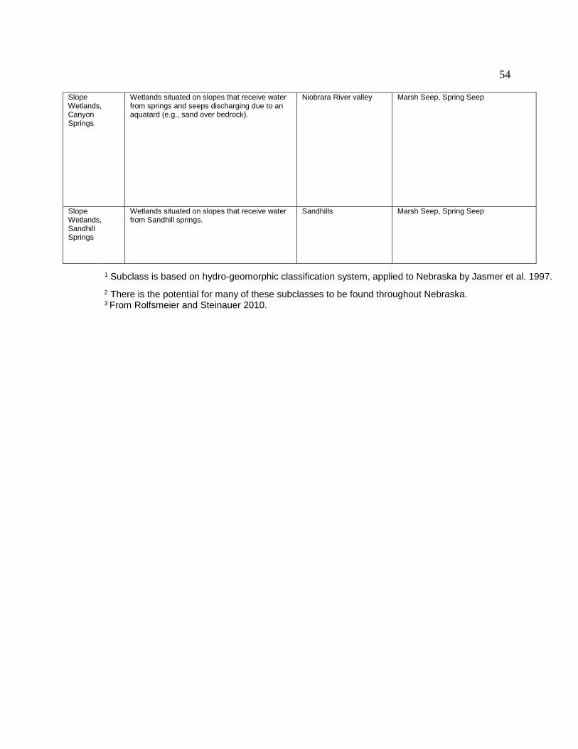
54
Slope Wetlands, Canyon Springs
Wetlands situated on slopes that receive water from springs and seeps discharging due to an aquatard (e.g., sand over bedrock).
Niobrara River valley Marsh Seep, Spring Seep
Slope Wetlands, Sandhill Springs
Wetlands situated on slopes that receive water from Sandhill springs.
Sandhills Marsh Seep, Spring Seep
1 Subclass is based on hydro-geomorphic classification system, applied to Nebraska by Jasmer et al. 1997. 2 There is the potential for many of these subclasses to be found throughout Nebraska. 3 From Rolfsmeier and Steinauer 2010.

55
Appendix B- NWI Priorities National Wetland Inventory re-mapping priorities for Nebraska1 Prepared by: Ted LaGrange and Randy Stutheit July 5, 2007 Wetland Complex Biologically
Unique Landscape (BUL)
NWI re-mapping priority- entire landscape
NWI re-mapping priority- trends only
Rationale
Lower North Platte River
Platte Confluence
1 3 Small BUL with lots of wetlands likely impacted by reduced river flow.
Missouri River Verdigre-Bazile Creek Watershed
2 NA Need better inventory of Niobrara silt delta.
Missouri River (entire)
3 1 Wetlands likely impacted by silt delta and dams. Need to compare trends in delta vs. unchannelized river.
Platte River (entire)
4 4 Important to obtain updated inventory and trends in Platte River reaches outside of Big Bend Reach.
Sandhills Borders Willow Creek Prairies
5 8 Lots of saturated meadows, with much drainage activity.
Sandhills Elkhorn Headwaters
6 NA Eastern Sandhills seem most impacted by stream down cutting. Existing Sandhills NWI seems to underestimate wetlands, especially meadows.
Sandhills Cherry County Wetlands
7 NA Existing Sandhills NWI seems to underestimate wetlands, especially meadows.
Sandhills Dismal Headwaters
8 NA Existing Sandhills NWI seems to underestimate wetlands, especially meadows.
Sandhills Borders Elkhorn Confluence
9 9 Eastern Sandhills seem most impacted by stream down cutting. Existing Sandhills NWI seems

56
Wetland Complex Biologically Unique Landscape (BUL)
NWI re-mapping priority- entire landscape
NWI re-mapping priority- trends only
Rationale
to underestimate wetlands, especially meadows.
Sandhills Sandhills Alkaline Lakes
10 NA Existing Sandhills NWI seems to underestimate wetlands, especially meadows.
Sandhills (entire) 11 7 Existing Sandhills NWI seems to underestimate wetlands, especially meadows.
Central Table Playas
Central Loess Hills
12 NA Existing NWI and soils data seem to adequately describe where the playas are.
Central Table Playas (entire)
13 2 These playa wetlands have likely been impacted by sedimentation and pit construction. Updated trend data would help to quantify this.
Southwest Playas (entire)
14 6 Only a very small portion of this complex is w/in the RWBJV admin. Boundary.
Todd Valley Playas
15 5 Only a small portion of this complex is w/in the RWBJV admin. Boundary. Existing NWI and soils data seem to adequately describe where the playas are.
Elkhorn River (entire)
16 10 Wetlands along the river appear to not have changed greatly over the years.
Sandhills Borders Keya Paha Watershed
17 15 Not very familiar with the wetlands and trends in this area.
Niobrara River Middle Niobrara River Valley
18 18 Wetlands along the river appear to not have changed greatly over the years.
Niobrara River (entire)
Niobrara River
19 19 Wetlands along the river appear to not have changed greatly over the years.
Lower Loup River
20 12 Wetlands along the river appear to not have changed greatly over the years.
Calamus 21 13 Wetlands along the

57
Wetland Complex Biologically Unique Landscape (BUL)
NWI re-mapping priority- entire landscape
NWI re-mapping priority- trends only
Rationale
River river appear to not have changed greatly over the years.
Middle Loup River
22 14 Wetlands along the river appear to not have changed greatly over the years.
North Loup River
23 16 Wetlands along the river appear to not have changed greatly over the years.
Snake River 24 17 Wetlands along the river appear to not have changed greatly over the years.
Republican River 25 11 River does not have a lot of wetlands and is not in a formal complex or BUL. With flow issues, some trend data would be useful. Prioritize upstream from Swanson Res.
Sandstone Prairies
26 20 Few wetlands in area.
Sandhills Borders (entire)
27 21 Few wetlands in area, outside of BULS covered above.
Loess Canyons
28 22 Few wetlands in area.
1 Excludes the Rainwater Basin and Central Platte wetland complexes since they were already re-mapped for NWI.

58
Appendix C- Restoration Practices The following are Wetland Priority Practices from the Nebraska Game and Parks Commission’s WILD Nebraska private lands program manual.
Priority 1—Wetland Restoration: 1a) Re-establishment (Full Hydrologic Restoration)—Activities that restore
hydrology to an area that historically was a wetland but has been drained to the extent that none of the area is currently a wetland.
1b) Rehabilitation (Partial Hydrologic Restoration)—Activities that restore hydrology to an area that historically was a wetland but has been partially drained to extent that only some of the area is currently a wetland.
1c) Rehabilitation (Vegetative Restoration)—Activities that restore natural plant communities on areas not hydrologically modified, but where the natural vegetation has been substantially altered.
Priority 2—Wetland Vegetation Management and Maintenance: Activities intended to improve or maintain existing desirable vegetation.
Priority 3—Wetland Enhancement (Alteration): Activities that alter the physical characteristics of an existing wetland to achieve specific social benefits without restoring the natural ecological functions (e.g., island construction, altering a seasonal wetland to make it a semi-permanent wetland).
Priority 4—Wetland Establishment (Creation): Activities that establish a wetland where one did not previously exist.
General The eight wetland activities listed in this document are generally organized by
Priority Practice Category, however, within a category no attempt has been made to prioritize. The following Activities are provided:
_ Drain Closure _ Irrigation Re-use Pit Closure _ Quick-Cycle Tailwater Recovery System Installation

59
_ Water-control Structure Installation _ Stream-weir Installation _ Silt and Fill Removal _ Vegetation Management _ Wetland Creation
DRAIN CLOSURE Priority Practice Category
_ Priority 1—Full or Partial Hydrologic Restoration.
Purpose _ To restore hydrology to wetlands that have been fully or partially drained.
General Concept Many wetlands have been fully or partly drained by ditches, culverts, head-
cutting gullies, and tiling. Closure of these drains will result in an increase of wetland acres and also restore, or partially restore, the natural hydrology to the wetland. The water-control activity will often be used in association with this activity.
The Seasonal Habitat Improvement Program (SHIP) of the Rainwater Basin Joint Venture is included as part of this activity. An existing cooperative agreement between the Commission, U.S. Fish and Wildlife Service, and the National Fish and Wildlife Foundation is in place to implement this activity in the Rainwater Basin. The main difference between SHIP and other drain closure projects is that SHIP closes the drainage only during the non-cropping season to provide water bird migration habitat. During the cropping season the cooperator is allowed to remove the water and crop the site. In some cases, this activity may be offered outside of the Rainwater Basin.
This activity works well when coupled with our partners' programs. An example is WRP and some CRP activities where those programs cover a portion of the cooperator's restoration costs and this activity under WILD Nebraska could pay the remaining cost-share.
Requirements and Technical Specifications Commission approved seeding of construction areas will be used as prescribed
to provide wildlife habitat and to prevent erosion.
IRRIGATION RE-USE PIT CLOSURE Priority Practice Category
_ Priority 1—Full or Partial Hydrologic Restoration.
Purposes _ Improve hydrology within a wetland and/or wetland watershed
General Concept Irrigation re-use pits have two major negative impacts on wetlands. When located
within the hydric soil footprint of a wetland, pits "concentrate" water and partially drain the surrounding wetland. This is especially damaging to small, temporary and seasonal

60
wetlands. The wetland surrounding the pit dries much more frequently, disrupting the natural wet/dry cycle and allowing for the conversion of the wetland. Pits located in the watershed of a wetland, although primarily designed to capture irrigation runoff, will also capture precipitation runoff. Intercepting natural runoff and preventing it from reaching the wetland also causes the wetland to dry more frequently than normal.
Irrigation re-use pit closure aids in the restoration of wetland hydrology. Should a cooperator determine that a pit is no longer necessary for farming activities, this activity can assist in filling the pit with soil back to original grade. An alternative would be the placement of a low-level earthen berm, with a control structure around the pit, to control water movement into it. The structure can be opened during irrigation season to capture tailwater, then closed the rest of the year to allow natural runoff to bypass the pit and reach the wetland. Quick-cycle tailwater recovery systems and Seasonal Habitat Improvement Projects are activities that can often be paired.
Requirements and Technical Specifications Excavations to obtain fill for the pit will need to be designed so they do not
puncture the clay seal of the wetland. Seeding of the construction area will usually not be necessary. However, if necessary, a Commission approved seeding will be used to provide wildlife habitat and to prevent erosion.
QUICK-CYCLE TAILWATER RECOVERY SYSTEM INSTALLATION Priority Practice Category
_ Priority 1—Partial Hydrologic Restoration.
Purpose _ To the fullest extent possible, restore and/or maintain the natural hydrology of
wetlands by encouraging the use of quick-cycle tailwater recovery systems.
General Concept In Nebraska's Rainwater Basin and elsewhere, pits have been dug in and near
wetlands to make these areas more suitable for cropping. Because most pits capture water during the entire year, the natural hydrology of the wetland is usually interrupted. By providing financial incentives to install quick-cycle tailwater recovery systems, cooperators may be able to fill-in existing pits or eliminate the need to excavate a new pit.
The quick-cycle works like a sump pump. Excess water from irrigation is directed into a small earthen pit or tank. A pump, switched on by a float returns the tailwater to the irrigation system resulting in increased efficiency. In the absence of a larger volume pit, runoff from precipitation reaches the wetland at a higher rate. Quick cycle systems can also benefit wetlands by directing irrigation tailwater away from a wetland to facilitate natural drawdown processes. Pit closure or pit filling or some other type of hydrologic modification must accompany this activity.
Requirements and Technical Specifications The system should be designed to capture irrigation tailwater and allow most
precipitation runoff to enter the wetland. Cost of return lines is not eligible for cost-share through the Commission.

61
WATER CONTROL STRUCTURE INSTALLATION Priority Practice Category
_ Priority 1—Partial Hydrologic Restoration, Vegetation Restoration
_ Priority 2—Vegetation Management and Maintenance
_ Priority 3—Alteration
Purpose _ To facilitate wetland restoration
_ To maintain the productivity of the wetland by effectively managing water levels
General Concept Wetland plant and animal communities are well adapted to the wet and dry
cycles that wetlands undergo. However, the hydrology of many wetlands has been altered to the point that the natural wet and dry cycles no longer occur. When this is the case, it is often necessary to provide for water control to restore the wetland or to maintain the productivity of the wetland. This activity will usually be paired with the Drain Closure activity.
Requirements and Technical Specifications This activity is only applicable for development of shallow water wetlands
(average depth of < 2.5 ft). This activity will not be used to cost-share on deep-water projects (e.g., lakes, and fish ponds), except in unique cases where the District staff design the project to benefit wetlands and wetland wildlife.
STREAM WEIR INSTALLATION Priority Practice Category
_ Priority 1—Full or Partial Hydrologic Restoration
Purposes _ To stop or reverse streambed degradation that negatively impacts wetlands.
General Concept Many streambeds in Nebraska have become severely degraded. Degradation
occurs when a stream cuts at an unnaturally accelerated rate, forming an incised channel with steep banks. A highly degraded stream affects wetlands by isolating them from over-bank flood flows, by potentially lowering ground water levels across the floodplain, and by allowing the development of erosive gullies that drain adjacent wetlands. Stopping degradation ensures that the wetlands on the floodplain will not become further isolated from ground water or over-bank water sources. Reversing degradation helps to restore wetlands by reconnecting them with ground water and over-bank water sources. This activity will often be paired with the Drain Closure activity where floodplain headcuts (erosive gullies draining wetlands) are plugged.

62
Requirements and Technical Specifications Approval of final plans by a registered professional engineer is needed for these
projects. Natural Heritage Program and Fisheries Division staff at the Game and Parks Commission will review these projects to ensure that the movement of aquatic life is not impaired.
STREAM RESTORATION Priority Practice Category
_ Priority 1—Full or Partial Hydrologic Restoration
Purposes _ To restore streams that have been altered by straightening or bank stabilization.
General Concept The functions of many streams in Nebraska have been altered by straightening
(channelization) and bank stabilization. These alterations have often resulted in a loss of fish and wildlife habitat because the natural dynamic processes of the stream are reduced or eliminated. This can result in a loss of total channel length, decreased structural diversity in the streambed, elimination of fringe wetlands, loss of adjacent grasslands and woodlands, altered nutrient dynamics in the stream, and reduced frequency of out-of-bank flows. This activity will be used to restore meanders to straightened streams and allow the stream bank to function naturally. This activity will often be paired with Stream Weir Installation.
Requirements and Technical Specifications Approval of final plans by a registered professional engineer is needed for these
projects. Natural Heritage Program and Fisheries Division staff at the Game and Parks Commission will review these projects to ensure that the movement of aquatic life is not impaired.
SILT AND FILL REMOVAL Priority Practice Category
_ Priority 1—Full and partial hydrologic restoration, Vegetation Restoration,
_ Priority 3—Alteration
Purposes _ To restore wetlands in areas that were filled and leveled.
_ To remove silt and sediment washed into wetlands in order to restore original basin profile, depths, and hydrology.
_ To remove invasive plant species and expose native plant seed banks.
_ To create varying water depths within the wetland and provide habitat diversity.
General Concept Many wetlands throughout the state have been filled (with soil, etc.) and leveled.
Other wetlands have been severely impacted by removal of perennial vegetation from the watershed leading to the deposition of silt into the wetland. The highly accelerated

63
rate of silt deposition leads to an alteration of wetland hydrology and can result in the establishment of invasive plants such as hybrid cattail, reed canary grass, and river bulrush, all of which out-compete more desirable plants. Also, silt buries the seed bank of desirable plant species preventing germination, acts as a "sponge"—absorbing water and making it unavailable to wildlife, and has a leveling effect—creating a wetland with a nearly flat bottom eliminating the micro-topography that provides habitat diversity.
This activity must be accompanied by a prescribed vegetative buffer and/or silt trap.
Requirements and Technical Specifications Wetlands that have been filled and leveled, as well as wetlands from which silt is
to be removed will need to have a depth-of-fill/silt and a topographic survey conducted to determine how much material should be excavated. Care must be taken when excavating in "perched" wetlands (such as Rainwater Basins and other playa wetlands) so that the clay seal underlying the area is not breached allowing water to seep away. A vegetated buffer and/or silt trap will almost always accompany this activity.
WETLAND CREATION Priority Practice Category
_ Priority 4—Creation
Purpose _ To create wetlands for the benefit of wildlife.
General Concept Although wetland creation is not a priority of this program, there are instances in
which creations can replace wetlands that have been drained or to complement the functions of existing wetlands. Creation, most often, is accomplished through excavation or by construction of a dam. This activity will generally be paired with one of the other wetland activities.
Requirements and Technical Specifications A wetland will not be created in an area where it will degrade existing wetlands or other unique natural communities. This activity is intended to emphasize shallow water habitat for wildlife; it is not intended for development of fisheries habitats. Creation of fish ponds will not be allowed under this activity, except in unique cases where the District staff design the project to benefit wetlands and wetland wildlife.

64
Appendix D- Wetland Management Information The information below is an excerpt from the Nebraska Game and Parks Commission document entitled Wetland Management Guidelines for Nebraska’s Wildlife Management Areas, authored by Ted LaGrange and Randy Stutheit in 2011. Management Philosophy
Management philosophy can be just as critical to sound wetland management as choosing the proper technique(s). The management philosophy on WMAs should include the following considerations:
1) Management is a Long-Term Process - Wetland management is usually a long-term process. However, some management objectives, such as modifying vegetation structure, can be accomplished in the short term. Managers should choose strategies that will accomplish both short-term and long-term objectives. Management regimes should be designed to mimic the natural processes that originally formed and maintained the wetlands. Particular emphasis should be placed on integration of burning and grazing to achieve long-term objectives.
2) Set Management Objectives - Management progress and effectiveness can only be measured if objectives have been set. These objectives should be quantifiable and timed-based, such as reduce reed canary grass by 50% in five years, or raise the wetland to Grade B quality in 10 years.
3) Use Adaptive Management - Adaptive management is simply the process of setting objectives, taking action through experimentation, measuring progress, and then adjusting strategies. Once management plans are implemented, they need to be evaluated yearly to see if management objectives are being met.
4) Be Flexible and Use Diverse Management - Flexibility is the key to sound management. Managers should be willing to use a diversity of techniques and change management methods, timing, and intensity on any given wetland to mimic natural disturbance regimes and help meet objectives. Also, management techniques don’t have to be applied over the entire wetland, but can be targeted to the portions of the wetlands in need. The primary tools to be used are water level management, invasive species control, fire, and grazing. Diverse management promotes both species and structural diversity. Simplified management, for example, use of only prescribed fire in the spring, can simplify diversity. External factors may also require managers to be flexible. Wetlands are resilient systems so it is often better to take action and learn from it as opposed to taking no management action at all.
5) Be Familiar With Native Plants - Knowledge of wetland plants is vital to sound management. Native plants, as well as exotic and invasive species, are indicators of condition and management needs. Changes in condition, both good and bad, will be reflected in the plant species composition. Many wetland plant species are good for wildlife and the ability to identify these species is valuable to wildlife managers. At-risk plant species may also be a management priority and managers should be able to identify these in the field.

65
6) Make High Quality Wetlands a Management Priority - Many high quality wetlands occur on WMAs. These wetlands are uncommon and need proper management to preserve them into the future. However, management resources and staff are limited and because of this, it is possible that not all wetland habitats on WMAs will receive proper management. It is essential that the high quality sites be given priority.
7) Management can be complex and challenging to implement and evaluate – Due to the complexities of natural systems, it can be difficult to know how to best manage a given site and to evaluate your results. When unsure what the best course of action is, seek counsel from other managers and people with wetland expertise and the most up-to-date information. Such a team approach may be very helpful in deciding on a course of action.
Guiding Principles
Guiding principles are general rules to direct management of wetlands on WMAs. Individual guiding principles may not apply to all situations. For example, it may not be feasible to provide structural diversity, or do large-scale management on a small wetland. Managers are encouraged to follow these guidelines where applicable:
1) Manage for native species diversity. 2) Mimic natural disturbance regimes. 3) Strive for structural diversity. 4) Decrease fragmentation. 5) Restore natural communities. 6) Emphasize large-scale management. 7) Control invasive species. 8) Manage for at-risk species where present.
CHAPTER 4 – MANAGEMENT Need for Management As noted earlier, Nebraska’s wetlands evolved with, and are dependent on natural disturbances such as fire and grazing. Lack of periodic disturbance (management) has severe consequences for wetlands. In previous decades, land managers sometimes assumed that little or no management was good for wildlife. Research has shown that in nearly all cases this assumption is false. In wetlands, a major consequence of little or no management is a dense and often monotypic stand of vegetation.
Another consequence of no management is uniform vegetative structure that is not conducive to use by a diverse suite of wildlife. Lack of management in wetlands can also lead to woody species encroachment resulting in habitat fragmentation and loss. Wetlands lacking proper management will move toward a state of dense, perennial vegetation such as cattails or reed canary grass. Active management not only

66
maintains and enhances habitat quality, but also is necessary to sustain healthy populations of wildlife.
The lack of management can lead to long-term damage to wetlands and can result in the need for a more expensive and time consuming restoration or enhancement project to be completed before proper management can begin.
Management Options 1) Grazing
Bison and elk were the primary pre-settlement large ungulate grazer of
Nebraska’s landscape. Today, under several management scenarios cattle can be used as a substitute for native grazers to attain management goals. Species other than cattle (e.g., goats, horses, hogs) may also be able to be used for management, but we currently have little experience with these species. When properly applied, cattle grazing can be used to alter wetland species composition, diversify vegetative structure, increase the amount of bare ground, reduce invasive species, increase the productivity of selected species, and increase the nutritive quality of the forage. Grazing is a tool that allows managers’ flexibility with regard to timing, frequency, and intensity of plant defoliation and trampling.
There are two basic methods of using grazing as a management tool in wetlands. One is to use cattle infrequently and for a limited period of time to address a particular management issue. The other scenario is to use cattle as part of a permanent grazing system such as rotational grazing. Which grazing system is best for a specific wetland depends on the land management objectives, existing plant composition, wetland size and condition, existing grazing infrastructure, and other factors.
The most critical issue when planning livestock grazing for wildlife management is determining the goals and objectives of the property you manage. How wetlands are managed varies across the state, according to the wildlife species desired, stocking rates, season of use, availability of livestock, and soil conditions. For example, the Rainwater Basin wetland complex is critical for spring and fall migration of waterfowl and shorebirds, thus early succession habitat conditions, and some exposed shoreline, in the spring and fall would be desirable. This could be accomplished by periodic heavy grazing in the spring and early summer. In the Sandhills, wetlands are part of the normal ranching operation and interspersed in upland rangeland, fenced in large pastures, and grazed in planned grazing systems. The waterfowl focus of the region is generally for waterfowl production rather than migratory habitat.
Season of grazing is critical to consider. Depending on management objectives, determining the desired plant(s) growing dates will dictate when grazing will be most effective. Invasive plant species will often require season-long grazing to hinder plant development. In wetlands with severe invasive plant problems, grazing should begin as soon as the plants start to develop as this is the time when the plants are most palatable. In wetlands that have a combination of native species and invasive species, such as reed canary grass, it may be necessary to graze two times, resting the site during annual plant growth, and then resuming grazing during the second growing phase. In wetlands where the goal is to provide more open water/bare ground and

67
annual plants, spring and early summer grazing may be sufficient. In these cases, cessation of grazing by mid-summer will allow for annual plant seed production that is an important source of wildlife food. Wetlands can be grazed annually in the Sandhills under conservative stocking rates, but the season of use should vary when planned grazing rotations are applied.
The stocking rate (animal unit months per acre) influences the overall intensity of herbivory and the physical impacts to wetlands. Light stocking rates allow cattle to select favored grazing species or areas. Heavy stocking rates force cattle to consume more plant species, including undesirable plants, and the hoof action can help to compact wetland soils, shred stems and tubers, and promote more bare ground. In the Rainwater Basin, you may desire a moderate to heavy stocking rate for a short duration while in the Sandhills, you may strive for conservative stocking rates to meet rangeland objectives and sustain good or excellent range condition. Wetlands in the Sandhills may be choked with cattails or bulrush whereby some temporary fencing with high stocking rates may be desirable to create open water habitat.
Conservation land managers sometimes avoid using high stocking rates in fear of damaging native wetland plant communities and wildlife habitat. Nebraska’s wetlands are adapted to severe periodic disturbances such as heavy grazing, fire, and drought. Wetlands will recover quickly from high-intensity, short-duration grazing. In some circumstances it may be necessary to conduct intense short-duration grazing for consecutive years. There are several grazing methods and systems that can be used on WMAs to benefit wetlands, biodiversity, and wildlife and that are acceptable to tenants. Some traditional grazing systems designed for livestock production, such as deferred rotational grazing and high intensity/short duration grazing, generally promote uniform disturbance through even distribution of grazing animals within a year. However, uniform disturbance generally does not promote the plant community heterogeneity desired by ecologists and wildlife biologist. In addition, deferred rotational grazing and high intensity/short duration grazing systems often require extensive grazing infrastructure and management and are not recommended for use on WMAs. On the other hand, if a WMA is adjacent to a private grazing operation, fitting the WMA grazing need into the private operation would be desirable with little infrastructure needed to meet wetland management objectives. Some grazing systems, such as fire-driven rotational grazing or patch-burn grazing, offer an alternative, heterogeneity-based approach to traditional grazing systems. The heterogeneity associated with patch-burn grazing and some other grazing systems may be critical for conservation of many wetland species.
There are even reasons to promote grazing systems that use intensive season-long grazing (up to 2-3 times the traditional stocking rate) in wetlands while other areas are rested for an extended period (1 to 2 years in some cases). Such systems promote heterogeneity of vegetation structure with both short and tall vegetation and open water/bare ground, within wetlands, which is important to wildlife. Native plant species may also be more adapted to such disturbance regimes than exotic species. In addition, many wetland species when rested for one or two years, then burned, are highly nutritious and palatable for large ungulates and other wildlife. For tenants, the increase in forage quality and quantity should make up for any perceived loss in forage due to the extended rest period.

68
2) Prescribed Burning
Lightning and Native American set fires were a primary disturbance in pre-settlement Nebraska prairies and wetlands. The pre-settlement fire return interval was estimated to be 3 to 5 years for tallgrass prairie (including the wetlands contained within the larger prairie landscape), 5 to 10 years for moist mixed-grass prairie, and 25 years for dry mixed-grass prairie (Samson and Knopf 1996). Native American set fires occurred primarily in two periods: March through May with a peak in April, and July through early November with a peak in October. Fires caused by lightning occurred generally during summer and early fall with most in July and August (Higgins 1986).
Managers need not exactly mimic pre-settlement fire return intervals as more frequent or infrequent fire return intervals may be needed to manage native habitats in today’s altered ecosystems. Also, present day season-of-fire need not follow historic season-of-fire as invasive species, limited resources, and burn windows require that prescribed fire be used during all seasons of the year when management objectives can be achieved. Burning can be justified for any season of the year as long as management objectives are met. For example, late spring fires can be used to control exotic cool-season grasses such as reed canary grass, late-summer fires can be used to reduce bulrush and cattail stands in wetlands, and winter or early spring fires can be used to open up wetlands for the spring migration.
3) Grazing and Fire Interaction
The fire-grazing model (patch-burn grazing system) is based on information that on Great Plains prairies, fire and grazing interacted through a series of positive and negative feedbacks to cause a shifting mosaic of vegetation patterns across the landscape (Fuhlendorf and Engle 2004). This same interaction likely also occurred in wetlands. The interruption of landscape scale processes, such as the fire-grazing interaction, may be the primary mechanism for loss of biodiversity in the Great Plains. Recently burned areas are typically preferred grazing sites for large ungulates and the combination of burning and grazing impacts vegetation composition and diversity to a greater extent than each action operating alone (Collins and Steinauer 1996). 4) Haying, Shredding, or Mowing
Haying, shredding, or mowing of wetlands is often less effective than grazing or burning for managing wildlife habitat. Like burning, these methods are nonselective management practices that cut and/or remove all vegetation. From a vegetative standpoint, haying, shredding, or mowing stress actively growing desirable and undesirable plants species equally. Though, if properly timed, these methods can place more stress on the undesirable species you are targeting. For example, summer haying can be effective in controlling some woody species and late spring haying or mowing can stress reed canary grass.
Timing of haying is often dictated by the forage quality of the hay. Producers prefer to hay when forage quality is high. Many Nebraska producers prefer to hay in

69
July to compromise between forage quality and quantity. Many nesting birds don’t complete hatching until late June, and others nest until mid-July. Early- to mid-summer haying can destroy nests or kill nestlings. In addition, annual, mid-summer haying stresses native warm-season plants and promotes exotic cool-season species, such as reed canary grass. Another option is to mow reed canary grass in late spring before it goes to seed. Allowing the mowed reed canary grass to dry, and then burning the mowed area can produce a hotter fire that may damage the roots and the unwanted seed bank. Most plants are low in below-ground energy (i.e. carbohydrate) reserves just prior to and during flowering, so mowing them at that time is the best way to stress them and over time possibly reduce their abundance.
Resting portions of wetlands, and then haying, shredding, or mowing on alternative years is a management option. Rest periods will allow native plants to restore root reserves and complete reproductive cycles. Rest from haying, shredding, or mowing should also increase forage production. Rested wetlands can also be spring burned to remove thatch and allow for easier hay removal later in the year.
In addition to the grazing-fire interaction that was discussed earlier, there can also be a grazing-mowing interaction. An early spring mowing can result in a rapid re-growth of vegetation that grazing animals will find very palatable. 5) Herbicide Application Herbicide application is not always a preferred management technique, but unfortunately, due to the difficulties that can be encountered in wetland management, it has become a necessary method of controlling some of the more aggressive species such as river bulrush, common reed, cattails, or reed canary grass. There are several strategies for using herbicide application:
1) Broadcast Application Using a Floater - Because temporary and seasonal wetlands dry more frequently during the year, it is often possible to utilize a float applicator to apply the herbicide.
2) Broadcast Application Using a Spray Plane - On larger and/or semi-permanent or permanent wetlands (e.g. reservoir or pond edge), it is often necessary and more economical to hire a spray plane for aerial application of the herbicide.
3) Spot Treatment Using a Pickup, Boat, or ATV - Wetlands that have scattered populations of the vegetation you are wanting to control do not need to be broadcast sprayed but should instead be spot treated with application of the herbicide directly to the target plants.
New herbicides are put on the market and labels are subject to change, so it is
best to keep current with the latest developments and not to rely solely on recommendations in this guide. There are several commercially available herbicides such as Rodeo® and other glyphosates labeled for use over water. Two other herbicides that are reportedly grass specific are Vantage® and Poast®. However, Vantage® and other herbicides not labeled for over water use (e.g. Roundup) must be applied only when the wetland site is dry. Spraying bulrush, cattail, or reed canary

70
grass in late August and early September with glyphosate controls these plants and has less effect on your other desirable wetland plants. 6) Mechanical (Disking, Roto-tilling) Using a heavy construction disk or roto-tiller to mechanically disturb the soil can be effective in reducing the population of unwanted vegetation on a site. Experience has shown that for disking alone to be effective, especially on species such as reed canary grass, a minimum of 3-4 passes with a heavy disk must be made. Roto-tilling is more effective because the tiller blades bring the roots, rhizomes, and tubers to the soil surface where they die more quickly by drying in the heat of summer, or freezing during the winter. However, most roto-tillers are narrow and require the tractor operator to go very slow which greatly limits the number of acres that can be effectively treated in a day. Roto-tilling is a good technique to use for smaller stands of undesirable vegetation or to create small openings. A more effective means of vegetation control utilizing a disk is the spray-disk-spray combination of treatments, especially for reed canary grass. Applying an herbicide in the summer when the reed canary grass is flowering and root reserves are at their lowest will usually kill most of the mature plants. Disking 10-14 days later will further destroy the vegetation and open the seedbed for new plants to sprout from the seed bank. Once the seedlings have reached a sufficient size, treating with the herbicide again will kill the new vegetation. It should be remembered that mechanical methods can destroy desirable vegetation along with the invasive species, so care should be applied when using this technique. The positive aspect of mechanical control is that it opens the wetland up for annual vegetation to quickly grow and establish. 7) Water Level Manipulation Water level manipulation has limited application on most of our Wildlife Management Areas. Many areas lack water control structures or groundwater wells to supplement and manipulate hydrology. Plus, many of our wetlands are shallow and it is difficult to flood the undesirable vegetation deep enough for a long enough period of time to eliminate it. An exception to this is managing the wetland fringe on ponds and reservoirs where this technique can actually be very successful. If this is a management technique available to you, preparing the site for flooding beforehand can increase success. Cut or burn the site prior to flooding. Next, flood the vegetation with a minimum of 6-18 inches of water over the top of the vegetation for at least 3 months during the growing season. After 3 months drain the site, if possible, or allow it to dry up naturally. Then, cut or burn the re-growth again in late fall, winter, or early spring and submerge once more during the next growing season. It is important that no stems or leaves be allowed to emerge from the water during the growing season as they will supply the plant they are originating from with oxygen thus preventing it from drowning. This requires close monitoring of the wetland and the water level during the 3-month period to ensure the vegetation remains submerged.

71
Water level manipulation can also be used to encourage desirable plant species. For detail on this, please refer to Chapter 5. 8) Mechanical Woody Vegetation Removal As used here, the term mechanical means cutting, sawing, clipping, mowing, and uprooting to remove woody vegetation. A variety of tools and equipment can be used to cut back or remove the vegetation, depending on the size of the wetland as well as the size and density of the woody vegetation to be removed. Tools used can range from limb loppers to chain saws to tractor driven shredders to dozers and backhoes. The amount of time required for different techniques is also an important consideration. If there are a significant number of trees, and/or they are of a large size, it may be necessary to hire a contractor to do the job for you. In most cases, all woody debris generated by this type of work should be cleaned up and hauled to an upland site where it can be burned and the residue buried. It may be acceptable in some eastern Nebraska wooded wetlands and riverine sites to leave a few logs and tree limbs in the wetland as would naturally occur in these situations. Many hardwood species such as willow, green ash, or cottonwood will re-sprout if simply cut off at ground level. Stumps of these species should be chemically treated within 5 minutes of cutting to prevent this from occurring. Note that the mechanical removal of wood vegetation may trigger Swampbuster and 404 permit compliance issues and if you are in doubt the appropriate agency should be contacted. Also, woody vegetation removal, including the timing, needs to be done in compliance with the Migratory Bird Treaty Act. 9) Wetland Management Considerations and Recommendations for Ponds and Reservoirs
Ponds and reservoirs are artificially created deepwater habitats with fringe
wetlands generally found within the littoral zone. They were constructed for the primary purposes of flood control and livestock watering. These water bodies can also provide important fish, wildlife, and water-based recreation opportunities on some Wildlife Management Areas. However, as the ponds and reservoirs have aged, these opportunities have been reduced due to a decline in the quality of the water and the fish and wildlife habitat. The Nebraska Game and Parks Commission has produced a Guide to help managers to improve wetlands associated with ponds and reservoirs, and this should be consulted for detailed information.

72
Appendix E- Table of Information Needs Wetland conservation information needs for Nebraska. Category Project/Actions to address information needs Region or complex Fauna Evaluate wildlife use and selection Central Table
Playas Fauna Survey the breeding and/or migrating birds Eastern Saline Fauna Measure the diversity and abundance of the
invertebrate community Eastern Saline
Fauna Survey the breeding and/or migrating birds Missouri River Fauna Survey the breeding bird community Rainwater Basin Fauna Measure the diversity and abundance of the
invertebrate community Rainwater Basin
Fauna Conduct a spring migration shorebird study Rainwater Basin Fauna Evaluate methods to allow fish passage around
structures used to address head-cutting streams Sandhills
Fauna Evaluate wildlife use and selection Southwest Playas Fauna Study the ecology of muskrats, esp. their
response to sedimentation making wetlands shallower
Statewide
Fauna Study reptile/amphibian use Statewide Fauna Evaluate wildlife use and selection Todd Valley Fauna Evaluate wildlife use and selection Western Alkaline Fauna Evaluate factors affecting amphibian community
composition Sandhills
Fauna Evaluate pollinator use of wetlands Statewide Fauna Monitor the health of cold water streams and
their associated wetlands Statewide
Fauna Develop population estimates for focal species using bird population survey by BCR, BUL, or other logical ecoregion, to track population change
Statewide
Fauna Determine if focal species are limited during the annual cycle by habitat quantity or quality
Statewide
Flora Conduct vegetation monitoring Eastern Saline Flora Evaluate vegetation management actions Rainwater Basin Flora Evaluate techniques to control cattail and reed
canary grass Statewide
Flora Evaluate moist-soil management techniques Statewide Flora/Fauna Evaluate the plant and animal community
response to wetland restorations Statewide
Flora/Fauna Evaluate Platte River slough restoration response by plants and wildlife
Platte River

73
Flora/Fauna Evaluate Sandhills grazing systems on wetland plants and wildlife
Sandhills
Flora/Fauna Evaluate grazing in wetlands: Influence of timing, stocking rate, and type of livestock
Statewide
Flora/Fauna Evaluate the response of wetland flora and fauna to the removal of invasive carp from Sandhills lakes/wetlands
Sandhills
Functions Evaluate Missouri River habitat improvement and mitigation projects
Missouri River
Functions Quantify historic and current playa numbers and assess function
Southwest Playas
Functions Evaluate overall changes in wetland distribution and condition
Statewide
Functions Evaluate the change in wetland size in relation to precipitation
Statewide
Functions Evaluate management practices (burning, grazing, disking, spraying, etc.)
Statewide
Functions Quantify greenhouse gas mass balance in Great Plains wetlands
Statewide
Functions Develop Hydrogeomorphic Models (HGM) for wetland subclasses
Statewide
Functions Evaluate the role of Great Plains wetlands in sequestering carbon
Statewide
Functions Evaluate the role of Great Plains wetlands in providing pollinator habitat
Statewide
Functions Develop and validate models quantifying wetland functions and services
Statewide
Functions Evaluate and model the effects of climate change on the condition of wetlands
Statewide
Functions Deploy webcams to evaluate wildlife use, and change in wetlands over time
Statewide
Functions Compare the amount of wetland wildlife foods produced among various wetland types
Statewide
Functions Evaluate importance the public places on various ecological goods and services (e.g., water filtration, hunting/viewing, etc.) provided by wetlands important to birds and other wildlife
Statewide
Hydrology Evaluate the hydrology of Eastern Saline wetlands, including supplementing the wetlands with saline groundwater
Eastern Saline
Hydrology Quantify the role of Southwest Playas and/or Central Table Playas in groundwater recharge
Playas
Hydrology Conduct a hydrology study to determine water budgets
Rainwater Basin
Hydrology Evaluate the relationship between wetlands and groundwater recharge
Rainwater Basin

74
Hydrology Evaluate the relationship between wetlands and water quality, esp. nitrates and pesticides
Rainwater Basin
Hydrology Evaluate the influence of culturally-accelerated sedimentation on groundwater recharge
Playas
Hydrology Evaluate the influence of various hydrology drivers on plant and wildlife communities
Sandhills
Hydrology Study the hydrology of Western Alkaline wetlands
Western Alkaline
Landuse Evaluate the effects of urban encroachment and disturbance
Eastern Saline
Landuse Evaluate conservation efforts on privately-owned wetlands
Statewide
Planning Prioritize Missouri River wetlands for restoration Missouri River Planning Conduct the aerial Annual Habitat Survey to
quantify wetlands and evaluate functions Rainwater Basin
Planning Develop a GIS/waterfowl model to evaluate and rank wetland restoration and acquisition
Rainwater Basin
Planning Develop BMPs for playas related to bird communities
Playas
Planning Evaluate wetland buffer needs and effectiveness Statewide Planning Categorize and evaluate of publicly owned
wetlands Statewide
Planning Determine the frequency of farming of wetlands Statewide Planning Develop a restorable wetlands database for
private lands and public lands Statewide
Planning Develop a mitigation monitoring system Statewide Planning Establish a cooperative tracking system between
Partners for Fish and Wildlife and WIP Statewide
Planning Establish a water-level monitoring program on WMA's
Statewide
Planning Track the extent and rate of tree encroachment in wetlands
Statewide
Planning Implement Structured Decision Making to evaluate wetland management actions
Statewide
Planning Evaluate wetland response to changing climate Statewide Planning Use techniques developed for the RWB Annual
Habitat survey to evaluate wetlands in other regions of the state
Statewide
Planning Track the presence and spread of invasive species and evaluate and implement methods to control these species
Statewide
Planning Conduct human dimensions surveys to better understand human perceptions of wetlands
Statewide
Planning Conduct studies to evaluate the economic benefits of wetlands
Statewide

75
Planning Develop GIS landscape design and decision support tools to help guide and prioritize wetland conservation
Statewide
Planning Use crowdsourcing data to understand human behaviors with wetland use
Statewide
Soils Determine sedimentation rates into playa wetlands, including the age of deposition
Playas
Soils Evaluate the effects of removing sediment, including on the wetland flora and fauna
Rainwater Basin
Soils Evaluate soil health of wetlands Statewide Soils Evaluate the relationship between hydric soil
indicators and hydrology Statewide