Embed Size (px)
Citation preview
EUROSION Case Study
1
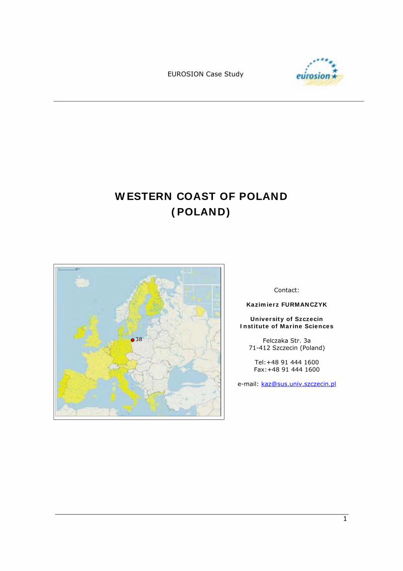
WESTERN COAST OF POLAND (POLAND)
Contact:
Kazimierz FURMANCZYK
University of Szczecin Institute of Marine Sciences
Felczaka Str. 3a
71-412 Szczecin (Poland)
Tel:+48 91 444 1600 Fax:+48 91 444 1600
e-mail: [email protected]
38

EUROSION Case Study
2
1. GENERAL DESCRIPTION OF THE AREA The study area is located at the West end of the Polish coast, near the Odra River mouth and extends westwards to the border with Germany. It is situated at the eastern part of the Pomeranian Bay (Figure 1).
Fig. 1: Location map of the studied area (Perry-Castañeda, 2002).
EUROSION Case Study
3
1.1. Physical process level
1.1.1 Classification
! General: Soft rock coasts, sedimentary plains with dune coasts and lagoons ! CORINE: beaches, rocky coast ! Coastal guide: coastal plain, cliffs
1.1.2 Geology
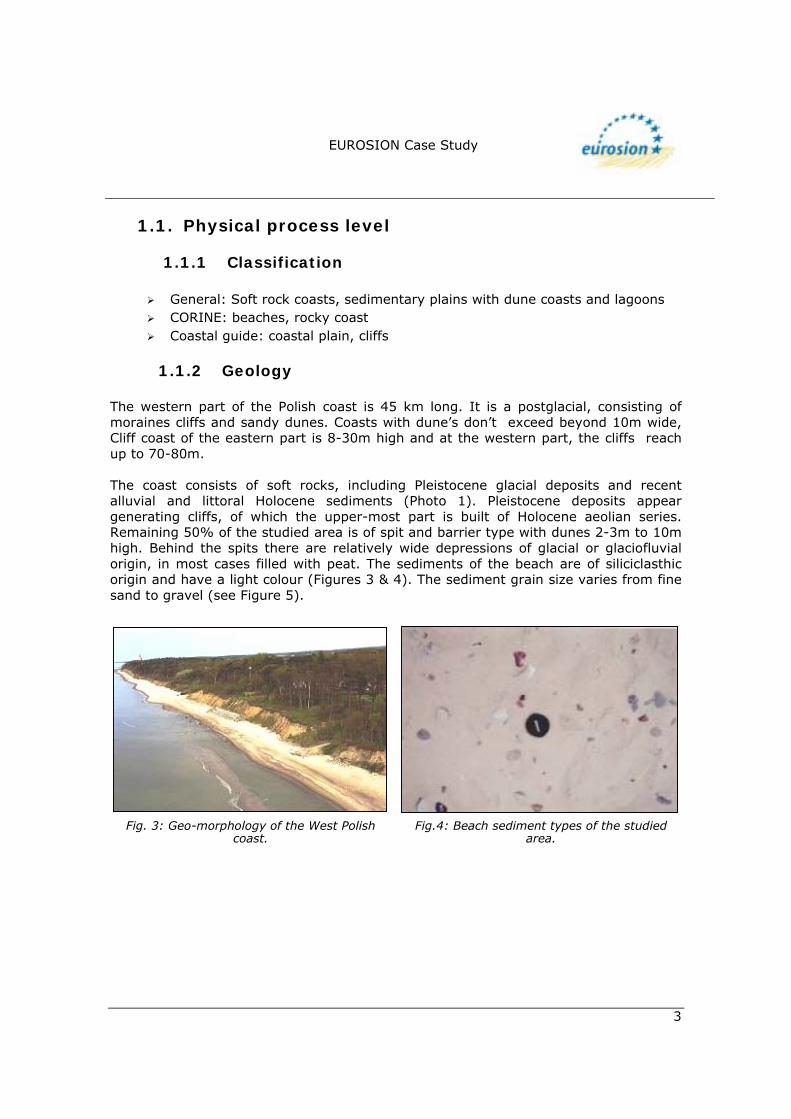
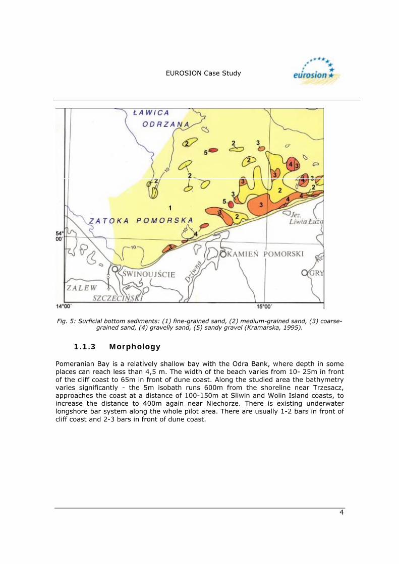
The western part of the Polish coast is 45 km long. It is a postglacial, consisting of moraines cliffs and sandy dunes. Coasts with dune�s don�t exceed beyond 10m wide, Cliff coast of the eastern part is 8-30m high and at the western part, the cliffs reach up to 70-80m. The coast consists of soft rocks, including Pleistocene glacial deposits and recent alluvial and littoral Holocene sediments (Photo 1). Pleistocene deposits appear generating cliffs, of which the upper-most part is built of Holocene aeolian series. Remaining 50% of the studied area is of spit and barrier type with dunes 2-3m to 10m high. Behind the spits there are relatively wide depressions of glacial or glaciofluvial origin, in most cases filled with peat. The sediments of the beach are of siliciclasthic origin and have a light colour (Figures 3 & 4). The sediment grain size varies from fine sand to gravel (see Figure 5).
Fig. 3: Geo-morphology of the West Polish coast.
Fig.4: Beach sediment types of the studied area.
EUROSION Case Study
4
Fig. 5: Surficial bottom sediments: (1) fine-grained sand, (2) medium-grained sand, (3) coarse-
grained sand, (4) gravelly sand, (5) sandy gravel (Kramarska, 1995).
1.1.3 Morphology
Pomeranian Bay is a relatively shallow bay with the Odra Bank, where depth in some places can reach less than 4,5 m. The width of the beach varies from 10- 25m in front of the cliff coast to 65m in front of dune coast. Along the studied area the bathymetry varies significantly - the 5m isobath runs 600m from the shoreline near Trzesacz, approaches the coast at a distance of 100-150m at Sliwin and Wolin Island coasts, to increase the distance to 400m again near Niechorze. There is existing underwater longshore bar system along the whole pilot area. There are usually 1-2 bars in front of cliff coast and 2-3 bars in front of dune coast.
EUROSION Case Study
5
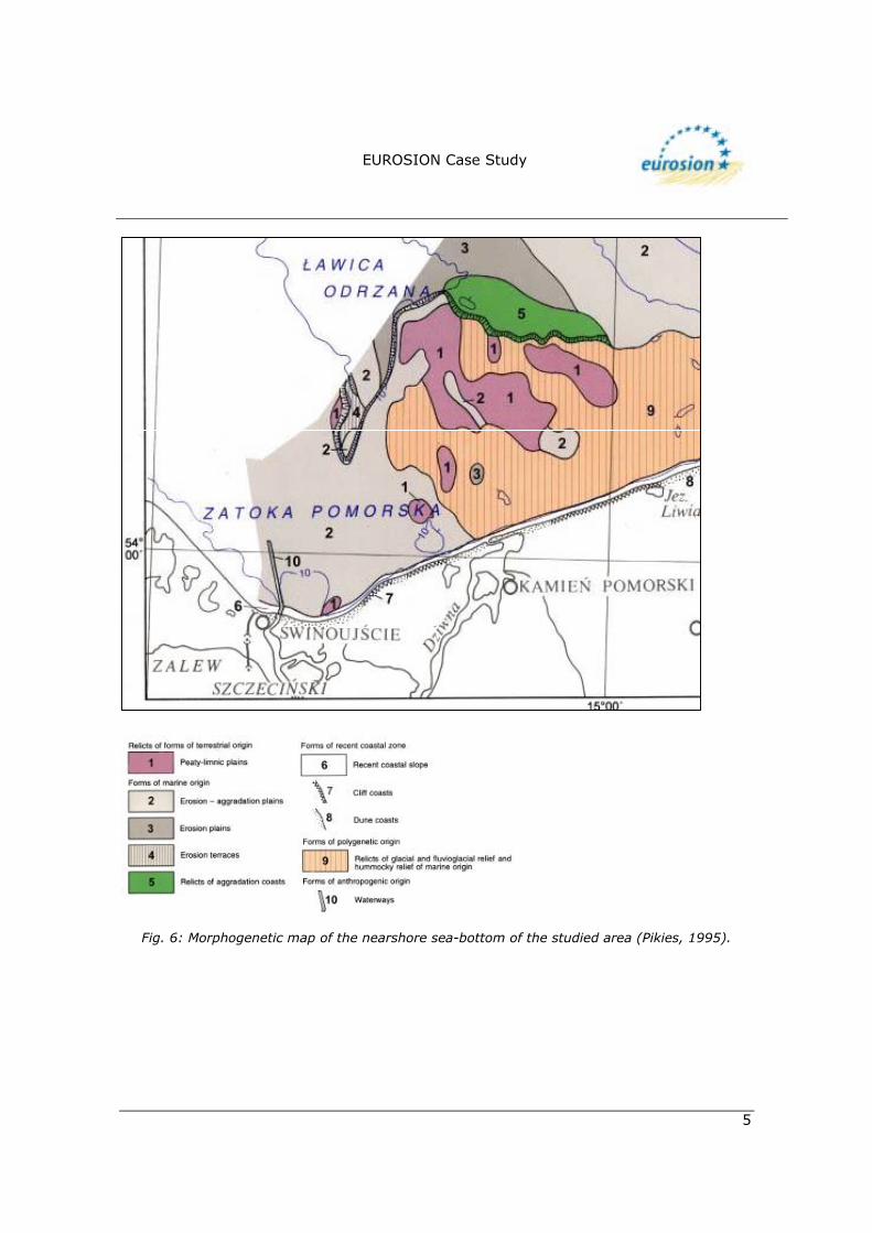
Fig. 6: Morphogenetic map of the nearshore sea-bottom of the studied area (Pikies, 1995).
EUROSION Case Study
6
1.1.4 Physical processes
Winds In this area there is a predominance of SW and W winds, throughout the year. Over the open sea the mean annual wind speed exceeds 6m/s. In the coastal zone, the highest mean monthly wind speeds (5-7m/s) are characteristic of the autumn-winter months. These seasons also contain the greatest number of days with strong winds. The frequency of stormy weather (above 8 Beaufort) can vary from 2 to 5%, depending on the month and area.
Waves The wave climate in Poland is diverse because of the wealth number of fetches and wind speeds occurring throughout the year. In the design for coastal protection, management and other maritime activities, one should take into account exceptional conditions causing extraordinary damage to the coast structures. With its N-NNW exposure, the study area is subjected to the most violent and most frequent storm surges. However, the maximum wave parameters are not so high as along other areas of the Polish coast. Tides The average tidal range in the Baltic Sea is small and it is estimated to be about 10 cm. Surface waves are the most important factor of the Baltic hydrodynamics.
Nearshore currents In the study area there are nearshore rip currents every 120m along the coast. Occurrence of irregular 2nd and 3rd underwater longshore bars serve as indicators of greater circulation systems. Crosshore output �gates� are identified in the coastal zone. They are visible as very wide system of channels of greater water mass movement towards the open sea.
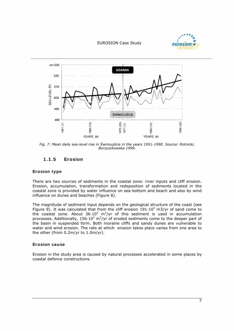
Sea level rise Recent examination of trends and statistical analysis of sea level datasets for the Polish coast, has partly confirmed some earlier conclusions drawn for mean sea level (and exposed new findings for extreme sea levels). The trends are shown in Figure 7.
EUROSION Case Study
7
Fig. 7: Mean daily sea-level rise in Świnoujście in the years 1951-1990. Source: Rotnicki,
Borzyszkowska 1999.
1.1.5 Erosion
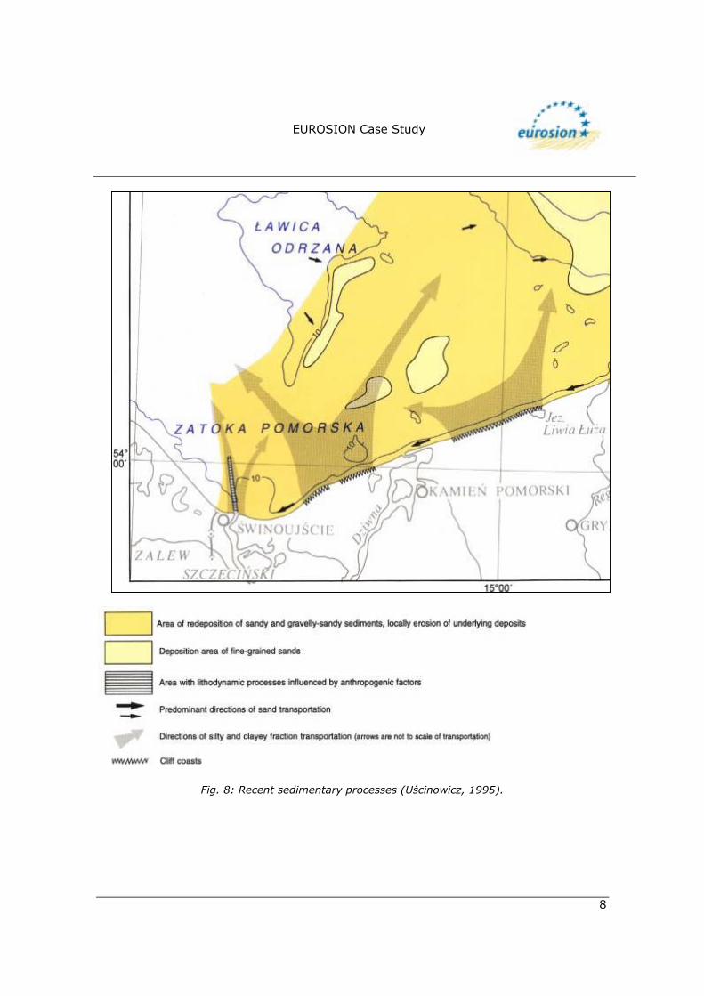
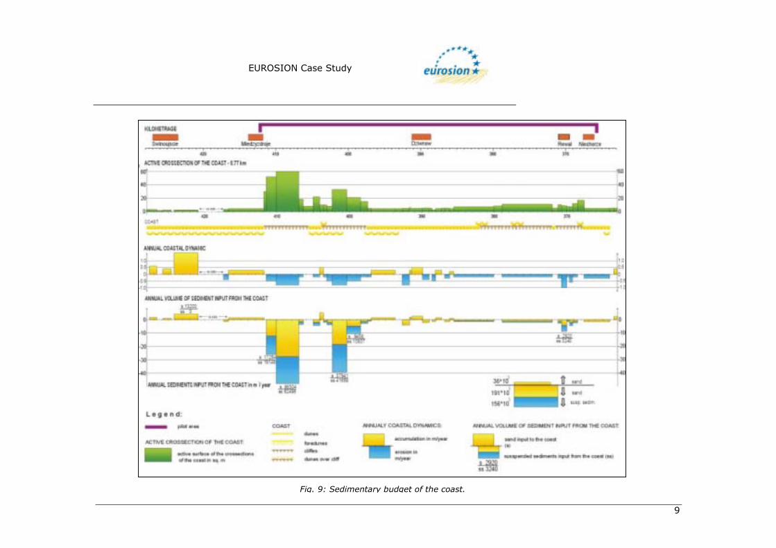
Erosion type There are two sources of sediments in the coastal zone: river inputs and cliff erosion. Erosion, accumulation, transformation and redeposition of sediments located in the coastal zone is provided by water influence on sea-bottom and beach and also by wind influence on dunes and beaches (Figure 8). The magnitude of sediment input depends on the geological structure of the coast (see Figure 9). It was calculated that from the cliff erosion 191·103 m3/yr of sand come to the coastal zone. About 36·103 m3/yr of this sediment is used in accumulation processes. Additionally, 156·103 m3/yr of eroded sediments come to the deeper part of the basin in suspended form. Both moraine cliffs and sandy dunes are vulnerable to water and wind erosion. The rate at which erosion takes place varies from one area to the other (from 0.2m/yr to 1.0m/yr).
Erosion cause Erosion in the study area is caused by natural processes accelerated in some places by coastal defence constructions.
EUROSION Case Study
8
Fig. 8: Recent sedimentary processes (Uścinowicz, 1995).
EUROSION Case Study
9
Fig. 9: Sedimentary budget of the coast.
WP 4.1 D.3. Report of UAB Pilot Sites EUROSION – Draft v.3
(February/2003)
10
1.2. Socio-economic aspects
1.2.1 Population rate
The population density is 116 inh/km2.
1.2.2 Major functions of the coastal zone
! Agriculture and forestry: the study area is divided into two rural communities, Dziwnów and Rewal. Agriculture and forestry play a secondary role in both communities. There are only 800ha of arable land in the Rewal community whilst and 200ha of arable land is found in the Dziwnów community. The forests occupy more then 2,000ha (in both communities).????
! Fisheries and aquaculture: the coastal and Baltic Sea fishery suffers severe
damages because of unfavourable economic circumstances. The lack of public financial support has also influenced the fisheries in this region.
! Urbanisation: In both communities, about 7500 sq. m of new flats are being yearly
constructed. Most of the houses constructed are second houses, pensions or private lodgings.
! Transport: there is only one good road connection with the main road network of
Szczecin. The road leading to the network is frequently congested and dangerous in the summertime. Road connection with the hinterland form the study area is bad.
! Tourism and recreation: this is the leading economic activity in both communities.
It is expected that the demand for health services and (water) sports services will grow after joining the EU by Poland.
! Ships and ports: the only harbour in the area is Dziwnów. There is also a small
marina for twenty yachts runned privately by Polmax.
1.2.3 Land use The main land use of the coastal strip in the study area is forestry and agricultural land. An important distribution of wetlands and meadows and few lagoons are still present in the area.
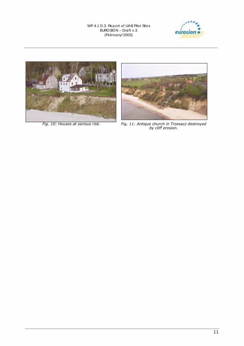
1.2.4 Assessment of capital at risk Expanding settlements is faced with the problem of erosion (Photos 10&11). Some of this settlements are at high risk (historical buildings too), so the owners and local government support every technical measures which can provide a long lasting protection of the coast.
WP 4.1 D.3. Report of UAB Pilot Sites EUROSION – Draft v.3
(February/2003)
11
Fig. 10: Houses at serious risk.
Fig. 11: Antique church in Trzesacz destroyed by cliff erosion.
WP 4.1 D.3. Report of UAB Pilot Sites EUROSION – Draft v.3
(February/2003)
12
2. PROBLEM DESCRIPTION
2.1. Eroding sites The cliff coast in the study area hasnumerous deep niches and abrasion undercut. Near-vertical slope, till slumps at the cliff crown, less frequently earth-flows and blockslides in the zone of ephemeral springs are also common. Destruction rate of the cliff is 30-80cm/ yr, with a tendency to increase. There are big accumulation areas near the mouth of Swina with a rate over 1.5m/yr whilst the area around the Wolin�s cliffs has a rate of about 0.7m/yr. In Śliwin coast rapid increase in landslides occurs in areas with a glacial raft of claystone (structural landslides). The landslide is facilitated by the nature of the coastal material. Cohesive ground is made made plastic and is joined by infiltrating rain water or leaks in drainage pipes and sewerage systems. Destruction rate: 80-150cm/yr, and up to 300cm/yr in periods of more intensive landslides. On the coast of the Rewal community, less intensive abrasion of low till cliff with aeolian- sand cover reinforced by vegetation is found. Broad beach (30-35m) with distinct fore-dune and earth falls form the cliff crown often stabilise the accumulation of colluvium at the foot of the cliff. Stable rate of retreat is observed up to 20cm/yr. On the coast of Trzęsacz steep cliff with shallow abrasion niches are found. Landslides, earth falls and mudflows and very narrow bars of beach (10-20m) are common. The disappearance of longshore bars and intensive transport of coarse-grained sand are observable. The present rate of destruction ranges between 20-80cm/yr (almost 2,400m over 630 years).
2.2. Impacts The study area faces severe erosion. The coastal protection practices are not found in all parts of the coast line. Opposite the hard seawalls, the beaches are observbed to be periodically disappearing (Niechorze, Rewal) or appearing by beach nourishment (Dziwnow). These municipalities have potential high risk of short term coastal erosion. The buildings are in danger of being destroyed within the time perspective of from 30 to 50 years. The exact number of years involved depends on the coastal protection methods used, the climate and the rise of the sea level. Alternative methods of combating erosion in the study area could be by both protecting the coast by beach nurishment and refusing the construction of buildings in areas that have high risk of erosion. Municipalities with less risk of erosion are located far from the coast. These areas are without protection measures against erosion. In these municipalities, the buildings closer to the coast can be destroyed between the periods of 30 � 50 years.

WP 4.1 D.3. Report of UAB Pilot Sites EUROSION – Draft v.3
(February/2003)
13
3. SOLUTIONS/MEASURES
3.1. Policy options Hold the line - Do nothing
Fig. 12: Coastal defence structures map and erosion rates in West Polish coast.
3.2. Strategy
3.2.1 Approach related to the problem
Protection of the buildings is a duty of the Maritime Office. Due to limited funds, coastal protection is often done in two fases. Firstly, the structures that are damaged are repaired and then protection measures are taken for properties that are found in areas that have high risks of eroding. The basic strategy for the later is the selection and protection of high risk areas on the coast. The rest of the coast is virtually left unattended until they are destroyed by natural coastal processes like erosion or accumulation of sediments. Among the suggested methods for coastal protection the frequently used method is beach nourishment supported by construction work and revegetation.
WP 4.1 D.3. Report of UAB Pilot Sites EUROSION – Draft v.3
(February/2003)
14
3.3. Technical measures
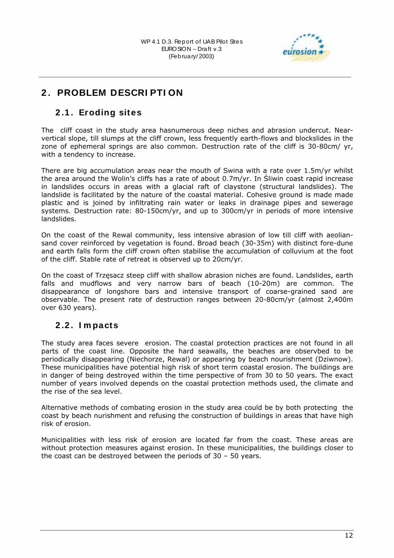
3.3.1. Historic measures Table 1: Historic coastal defence measures in West Polish coast.
Dziwnow Groins 1918 1979 Seawalls 1956-60 Hard seawalls 1984 Beach nourishment 1996-2000 Rewal-Niechorze area Groins 1874 1914-1929 1971 Seawalls 1900 1955 1984-1986 1996-1998
3.3.2. Type
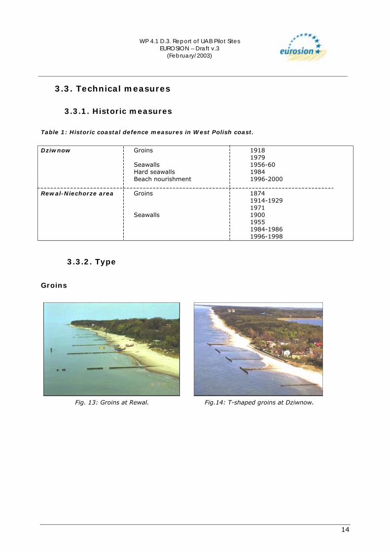
Groins
Fig. 13: Groins at Rewal.
Fig.14: T-shaped groins at Dziwnow.
WP 4.1 D.3. Report of UAB Pilot Sites EUROSION – Draft v.3
(February/2003)
15
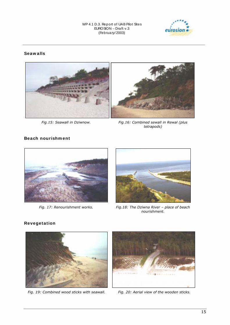
Seawalls
Fig.15: Seawall in Dziwnow.
Fig.16: Combined sewall in Rewal (plus tetrapods)
Beach nourishment
Fig. 17: Renourishment works.
Fig.18: The Dziwna River � place of beach nourishment.
Revegetation
Fig. 19: Combined wood sticks with seawall.
Fig. 20: Aerial view of the wooden sticks.
WP 4.1 D.3. Report of UAB Pilot Sites EUROSION – Draft v.3
(February/2003)
16
3.3.3. Technical details In the past different kinds of groins were constructed in the areas higly vulnerable to erosion. Groins constructed include single groins, double groins, double groins with concrete plates and T�shaped groins. Along the West of the Polish coast, different kinds of seawalls are cosntructed:
! Light seawall: built from concrete blocks. The blocks have different shapes and are arranged in rows along the coast. This method of wall construction is old and is no longer used. Remnants of this type of wall is found on the seawall in Trzesacz.
! Medium seawall: Remnants of this type of wall is found in Dziwnow and Wolin
National Park. ! Hard seawall: This method of construction has been used in different places at
different times and for various purposes. In Niechorze this measure was performed in 1900 in order to reinforce the lighthouse. In Dziwnow this construction was done in order to protect the buildings which are located on the very narrow Dziwnow Split. In Trzesacz this type of wall is constructedin order to protect the remaining wall of a historical church which was constructed in the 15th century. The church is constructed at 2.5km from the sea.
! Combined seawall: This type of wall is considered to be the target for seawall
constructors because of its advantages over the other sea walls. The method involved in the construction is flexible and can be used to improve or rebuild other types of seawalls.
Beach nourishment was done in Dziwnow in 1996. It consisted of a sand filling of about 67,000m3 dredged from shipping route to the Dziwnow harbor. The sand was deposited about 300m along the beach. The nourishment was repeated after 4 years (in 2000). The locations of all the seawalls in the study area are presented in Figure 12 above.
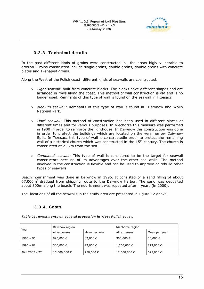
3.3.4. Costs Table 2: Investments on coastal protection in West Polish coast.
Dziwnow region Niechorze region
Year All expenses Mean per year All expenses Mean per year
1985 � 95 820,000 � 82,000 � 300,000 � 30,000 �
1995 � 02 300,000 � 43,000 � 1,250,000 � 179,000 �
Plan 2003 - 22 15,000,000 � 750,000 � 12,500,000 � 625,000 �

WP 4.1 D.3. Report of UAB Pilot Sites EUROSION – Draft v.3
(February/2003)
17
4. EFFECTS AND LESSONS LEARNT
4.1. Effects related to erosion Results of works geard towards protecting the coasts are not always the predicted results but the experiences gained from past projects have proved to be usefulin most of the new projects. The only places where cliff erosion was stopped are the areas along the coast where hard seawalls were constructed. In these same places it can be observed that the beaches either totally disappear or they become narrower. During the construction of seawalls and groins, applying the method of beach nourishment increases the concentration of suspended matter. Side effects of this method include intensive coastal erosion around the protected area of the coast.
4.2. Effects related to socio-economic aspects Coastal protection using hard seawalls causes erosion of other areas of the coast that are unprotected. Beaches situated in front of the seawall often disappear. As a result, tourist activities in such areas are reduced.
4.3. Relations with ICZM Recent techniques used in Integrated Coastal Zone Management does not exist in Poland. Recently two ICZM projects have been launched in Poland as a means of introducing the new techniques of ICZM. These projects are still in their initial phases of implimentation and they include: ICZM for Szczeciński Lagoon and ICZM for Wiślany Lagoon. Both projects are bilateral. They are being implemented by both the Polish and the German governments. The Guidelines for the ICZM project in Szczeciński Lagoon� is prepared in 2000. Agenda 21 is locally applied for Szczeciński Lagoon� This has lead into the involvement of the Polish�German cooperation at the very beginning of the project. Besides the ICZM projects, only the national project called �Strategy for coastal protection� is expected to have effect on the area covered by this study.
4.4. Conclusions
4.4.1 Effectiveness
From the evolutionary point of coastal protection along the West of the Polish Coast,only hard seawalls have ever stopped the process of coastal erosion. The hard seawall is found to be effective in Niechorze, Rewal�Sliwin and Dziwnow.
! These seawalls require expensive conservation activities. Damages on the walls need constant repairs. The oldest of the walls (in Niechorze) is already rebuilt.
! Around the seawalls, coastal erosion is often increased. This requires an extra
effort for extending the coastal protection.

WP 4.1 D.3. Report of UAB Pilot Sites EUROSION – Draft v.3
(February/2003)
18
! In front of the seawalls the beach is intensively eroded; in Niechorze the beach disappeared completely; in Dziwnow, RewalSliwin the beach is gradually disappearing. The width of the beaches is ever becoming narrower.
The soft seawalls are less effective. The soft sea walls built in the 50�s did not last for long.. The concrete blocks from the walls are buried in sand and the remains of the wooden or concrete piles are found sticking out in either the beach area or in the water and are a danger for the people. It is very often that the groins do not yield the expected result of returning to the original situation before the construction. Because of this, theofficers from the Maritime Office prefer removing the damaged groins completely.
4.4.2 Gaps in information The published scientific works from this region show insufficient knowledge about coastal processes and coastal change regularities. This knowledge is is essential for prognosing the changes and to develop coastal protection strategy. There is lack of social participation in decision making processes geared towards the management of the coastal zones.
WP 4.1 D.3. Report of UAB Pilot Sites EUROSION – Draft v.3
(February/2003)
19
5. REFERENCES Basinski, T.; Pruszak, Z.; Tarnowska, M.; Zeidler, R. (1993). Ochrona brzegów morskich, IBW PAN, Gdańsk. Dobracka, E.; Dobracki, R. (1995). Geology and geodynamic of the cliff coast between Niechorze- Trzęsacz. In: Polish Coast- Past, Present and Future. Ed. Rotnicki K. Sp. Is. Journal of Coastal Research, p. 283- 286. Furmanczyk, K.; Musielak, S. (1999). Circulation systems of the coastal zone and their role in South Baltic morphodynamic of the coast. Quaternary Studies in Poland. Sp.Is., p.91-94. Kramarska, R. (1995). Surficial bottom sediments. Geological Atlas of the Southern Baltic, Table XXIV, Polish Geological Institute. Musielak, S.; Furmanczyk, K. (1994). Remote sensing analysis at the Pomeranian Bay coast line variations, Proceedings at 5th German-Polish Seminar 93 on Coastal and Estuary Dynamics, Vilm Oct. 1993, 141 � 145 Musielak, S.; Stolarczuk, A. (1994). Longshore bars morphodynamics. Marine Sciences no. 2, p. 37- 60 (in Polish). Pikies, R. (1995). Morphogenesis sea bottom. Geological Atlas of the Southern Baltic, Table XXV, Polish Geological Institute. Rotnicki, K.; Borzyszkowska, W. (1999). Accelerated sea-level rise and its components at the Polish Baltic coast in the years 1951- 1990. In: Ewolucja geosystemów nadmorskich południowego Bałtyku. Szczecin, p. 141- 160 (in Polish). Tomczak, A. (1995). Geological structure and Holocene evolution of the Polish Coastal Zone. In: Polish Coast- Past, Present and Future. Ed. Rotnicki K. Sp. Is. Journal of Coastal Research, p. 15- 32. Tomczak, A. (1995). Geological structure of the coastal zone (I). Geological Atlas of the Southern Baltic, Table XXXIII, Polish Geological Institute. Uscinowicz, S. (1995). Recent sedimentary processes. Geological Atlas of the Southern Baltic, Table XXVIII, Polish Geological Institute. Zeidler, R.B. et al. (1995). Wind, wave and storm surge regime at the Polish Baltic Coast. In: Polish Coast- Past, Present and Future. Ed. Rotnicki K. Sp. Is. Journal of Coastal Research, p. 33- 56
Internet: Ministry of Environment www.mos.gov.pl Ministry of Infrastructure www.mi.gov.pl Maritime Institute www.im.gda.pl
WP 4.1 D.3. Report of UAB Pilot Sites EUROSION – Draft v.3
(February/2003)
20
Meteorology and Water Management Institute www.imgw.pl Polish Geological Institute www.pgi.waw.pl Institute of Hydroengineering of the Polish Academy of Sciences www.ibwpan.gda.pl Oceanological Institute of the Polish Academy of Sciences in Sopot www.iopan.gda.pl Institute of the Environmental Protection in Gdynia www.ios.edu.pl Hydrographic Office of the Polish Navy in Gdynia www.mw.mil.pl/hydro Maritime Office in Szczecin www.ums.gov.pl Maritime Office in Slupsk www.umsl.gov.pl Maritime Office in Gdynia www.umgdy.gov.pl University of Szczecin www.univ.szczecin.pl University of Poznan www.amu.edu.pl University of Gdansk www.univ.gda.pl Technical University of Szczecin www.tuniv.szczecin.pl Technical University of Gdansk www.pg.gda.pl Central Center of the Geodesy Documentation and Cartography in Warszawa www.codgik.waw.pl European Union for Coastal Conservation EUCC (www.eucc.szc.pl/EUCC.htm website of Integrated Coastal Zone Management Project www.sus.univ.szczecin.pl/~studzzop website of CoastLearn Project www.netcoast.nl/coastlearn/website/index.htm Perry-Castañeda Library Map Collection: http://www.lib.utexas.edu/maps