Embed Size (px)
Citation preview

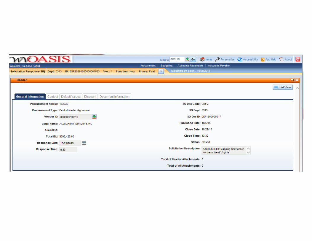
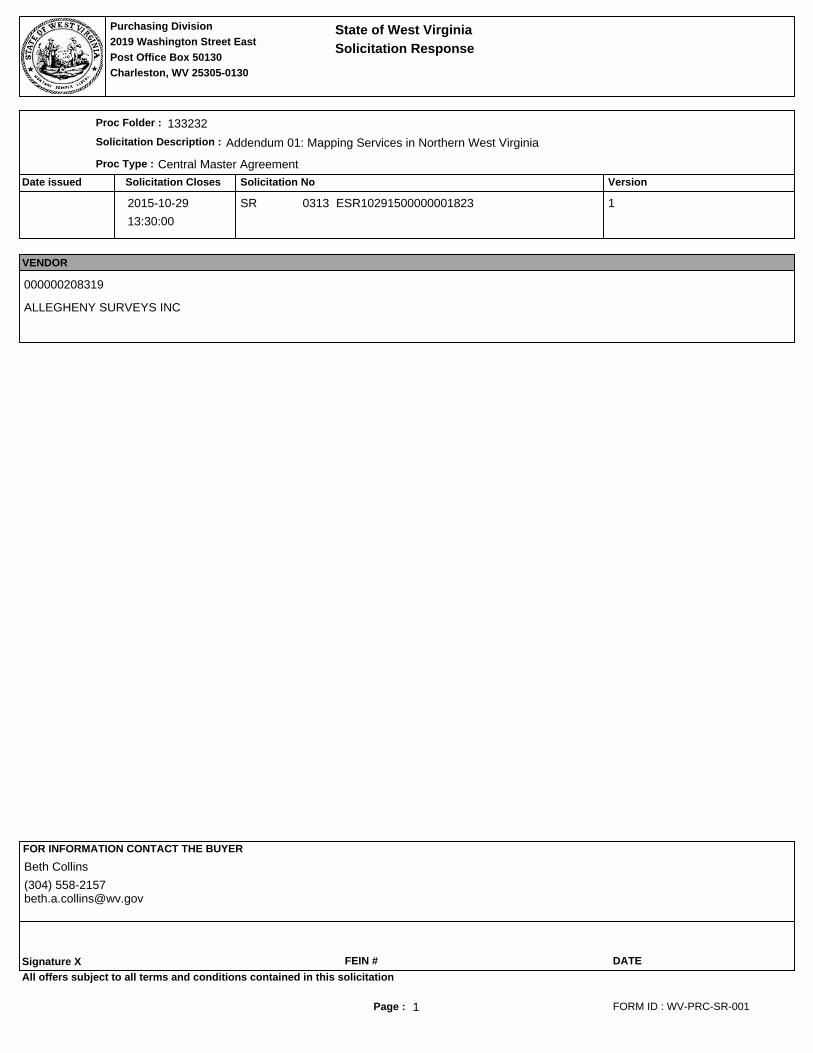
The following documentation is an electronically‐submitted vendor response to an advertised solicitation from the West Virginia Purchasing Bulletin within the Vendor Self‐Service portal at wvOASIS.gov. As part of the State of West Virginia’s procurement process, and to maintain the transparency of the bid‐opening process, this documentation submitted online is publicly posted by the West Virginia Purchasing Division at WVPurchasing.gov with any other vendor responses to this solicitation submitted to the Purchasing Division in hard copy format.
Page : 1
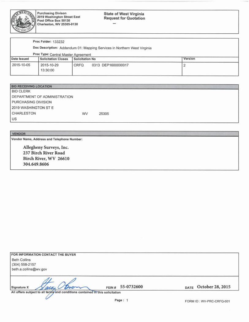
VersionSolicitation NoSolicitation ClosesDate issued
Proc Folder :
Solicitation Description :
Proc Type :
Solicitation Response
Purchasing Division2019 Washington Street East
Charleston, WV 25305-0130Post Office Box 50130
State of West Virginia
133232
Addendum 01: Mapping Services in Northern West Virginia
Central Master Agreement
2015-10-29
13:30:00
SR 0313 ESR10291500000001823 1
VENDOR
000000208319
ALLEGHENY SURVEYS INC
FOR INFORMATION CONTACT THE BUYER
Signature X FEIN # DATE
All offers subject to all terms and conditions contained in this solicitation
FORM ID : WV-PRC-SR-001
Beth Collins
(304) [email protected]
Page : 2
Line Comm Ln Desc Qty Unit Issue Unit Price Ln Total Or Contract Amount
Comm Code Manufacturer Specification Model #
Extended Description :
1 Control Surveying 600.00000 HOUR $130.000000 $78,000.00
81151601
Control Surveying
Line Comm Ln Desc Qty Unit Issue Unit Price Ln Total Or Contract Amount
Comm Code Manufacturer Specification Model #
Extended Description :
2 Topographic, Planimetric and CheckSurveying
1800.00000 HOUR $90.000000 $162,000.00
81151601
Topographic, Planimetric and Check Surveying
Line Comm Ln Desc Qty Unit Issue Unit Price Ln Total Or Contract Amount
Comm Code Manufacturer Specification Model #
Extended Description :
3 Terrestrial LIDAR Collection 600.00000 HOUR $120.000000 $72,000.00
81151601
Terrestrial LIDAR Collection
Line Comm Ln Desc Qty Unit Issue Unit Price Ln Total Or Contract Amount
Comm Code Manufacturer Specification Model #
Extended Description :
5 Topographic Mapping - AerialPhotography (0-25 Acres)
15.00000 ACRE $200.000000 $3,000.00
81151601
(including LIDAR Collections)
List only one rate for each category.
Page : 3
Line Comm Ln Desc Qty Unit Issue Unit Price Ln Total Or Contract Amount
Comm Code Manufacturer Specification Model #
Extended Description :
6 Topographic Mapping - AerialPhotography (25-50 Acres)
30.00000 ACRE $110.000000 $3,300.00
81151601
(including LIDAR Collections)
List only one rate for each category.
Line Comm Ln Desc Qty Unit Issue Unit Price Ln Total Or Contract Amount
Comm Code Manufacturer Specification Model #
Extended Description :
7 Topographic Mapping - AerialPhotography (50-100 Acres)
75.00000 ACRE $50.000000 $3,750.00
81151601
(including LIDAR Collections)
List only one rate for each category.
Line Comm Ln Desc Qty Unit Issue Unit Price Ln Total Or Contract Amount
Comm Code Manufacturer Specification Model #
Extended Description :
8 Topographic Mapping - AerialPhotography (Over 100 Acres)
125.00000 ACRE $35.000000 $4,375.00
81151601
(including LIDAR Collections)
List only one rate for each category.
Line Comm Ln Desc Qty Unit Issue Unit Price Ln Total Or Contract Amount
Comm Code Manufacturer Specification Model #
Extended Description :
9 Licensed Land Surveyor 600.00000 HOUR $95.000000 $57,000.00
81151601
Professional Rates (Listed Disciplines Only)
Page : 4
Line Comm Ln Desc Qty Unit Issue Unit Price Ln Total Or Contract Amount
Comm Code Manufacturer Specification Model #
Extended Description :
10 Survey Manager 1200.00000 HOUR $65.000000 $78,000.00
81151601
Professional Rates (Listed Disciplines Only)
Line Comm Ln Desc Qty Unit Issue Unit Price Ln Total Or Contract Amount
Comm Code Manufacturer Specification Model #
Extended Description :
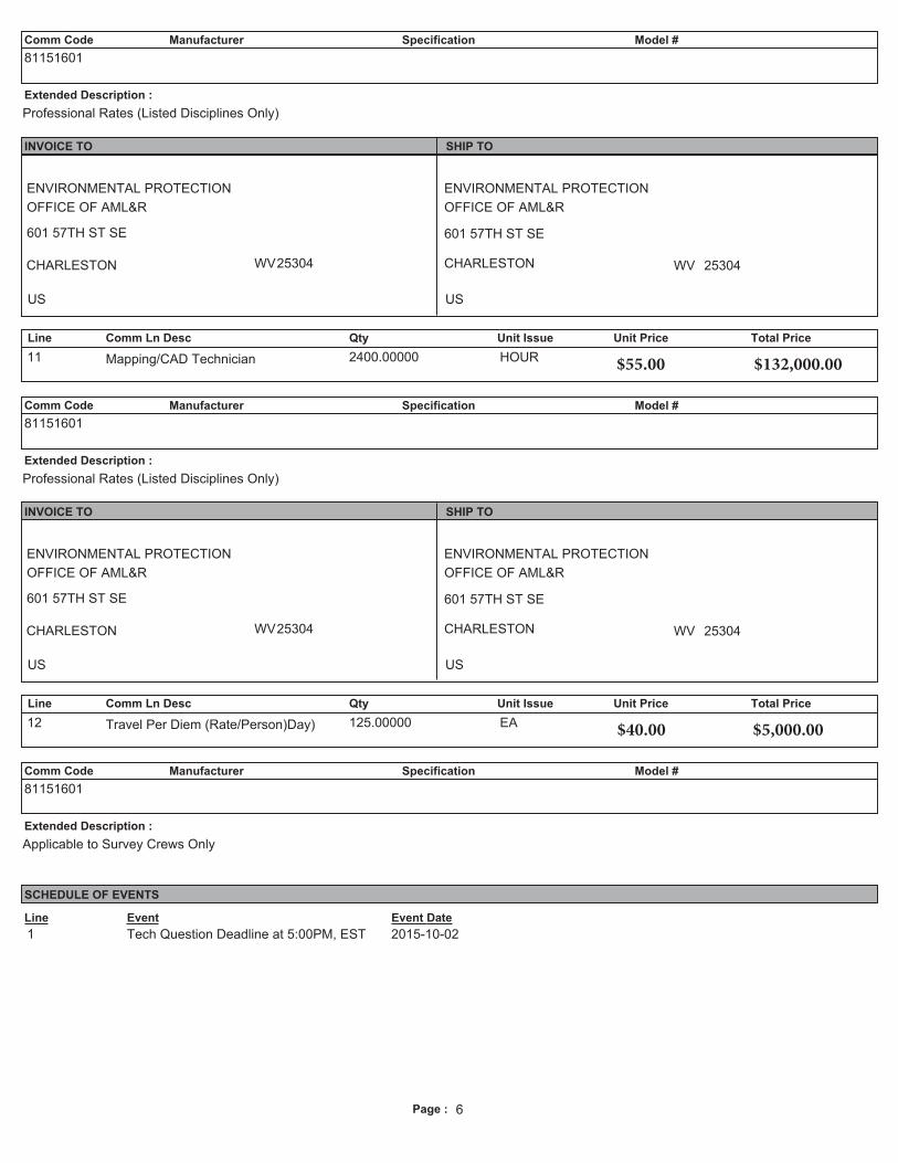
11 Mapping/CAD Technician 2400.00000 HOUR $55.000000 $132,000.00
81151601
Professional Rates (Listed Disciplines Only)
Line Comm Ln Desc Qty Unit Issue Unit Price Ln Total Or Contract Amount
Comm Code Manufacturer Specification Model #
Extended Description :
12 Travel Per Diem (Rate/Person)Day) 125.00000 EA $40.000000 $5,000.00
81151601
Applicable to Survey Crews Only
SEALED BID
Buyer: Beth A. Collins RFQ No.: DEP1600000017 (Version 2) Bid Opening Date: October 29, 2015 Bid Opening Time: 1:30 PM, EST
West Virginia Department of Environmental Protection Office of AML&R 601 57th Street SE
Charleston, WV 25304
C/O Department of Administration, Purchasing Division
2019 Washington Street, East Charleston, WV 25305
October 28, 2015 West Virginia Department of Environmental Protection Office of AML&R 601 57th Street SE Charleston, WV 25304 c/o Beth A. Collins Department of Administration, Purchasing Division 2019 Washington Street, East Charleston, WV 25305 Re: Solicitation No. CRFQ 0313 DEP1600000017 Version 2 Dear Ms. Collins: Allegheny Surveys, Inc. appreciates the opportunity to provide this response to your CRFQ for “Mapping Services in Northern West Virginia (Open-End)”. Allegheny Surveys, Inc., established in 1988, is a full service surveying firm with four (4) offices throughout West Virginia, located in Alum Creek, Birch River, Bridgeport and Ranson. Our firm currently has sixty (60) employees, in the four offices, and the capacity to field thirteen (13) survey crews. It employs thirteen (13) Professional Surveyors and one Professional Engineer, all licensed in West Virginia. Our firm is highly qualified and experienced in performing the services you require, and meets all requirements listed in the Specifications for the “Request for Quotation – Mapping Services in Northern WV”. Following are responses to the line items in the Specifications: 3.3 Mapping Consultant Qualifications Requirements 3.3.1 Professional capabilities and staff Professional Surveyors
Birch River Office
Stacey O. Brown - WV PS #2180 Marshall W. Robinson – WV PS #835 Ben R. Singleton – WV PS #2092 Damon L. Wilkewitz – WV PS #2123 Roger D. Tomlin – WV PS #2071 Dwayne A. Hall – WV PS #2089SU

2
Alum Creek Office David W. King - WV PS #2004
Bridgeport Office Bradley D. Miller – WV PS #2167 Dwayne D. Matheny – WV PS #2070 Kenneth J. Plum – WV PS #2216 William G. Yetzer – WV PS #2213
Ranson Office Karen K. Brill – WV PS #908 Matthew R. Jones – WV PS #2128
Field Staff and Survey Crew Birch River Office
Rick Bloir – Senior Party Chief Johnathan McKinney – Rodman Sam Gibson – Rodman
Alum Creek Office David Fisher – Party Chief Matthew Lenox – Rodman Thomas Johnson – Rodman
Bridgeport Office Josh Smith – Party Chief Phillip Harper - Rodman Zackary Lyons - Rodman
Ranson Office Matthew Jones – Party Chief Casey Stollings – Rodman
CAD Technicians (AutoCAD Version 2016) Birch River Office
Scott Brown Tim Rutledge
Alum Creek Office Tony Jeffery
Bridgeport Office Christopher Renneman Derek Rader Zackary Lyons
Ranson Office Matthew Jones
Capacity to process and complete multiple projects within the designated time frames
With the ability to field thirteen (13) survey crews and seven (7) CAD Technicians available to perform the mapping, Allegheny Surveys, Inc. has the capacity to process and complete multiple projects in the timeframe required by the WV DEP.
3
Mapping Consultant must submit the following at the time of bid:
Names of individuals performing work including registration/licensing numbers. Stacey O. Brown, Professional Surveyor – WV PS #2180 Damon L. Wilkewitz, Professional Surveyor – WV PS #2123 David W. King, Professional Surveyor – WV PS #2004 Bradley D. Miller, Professional Surveyor – WV PS #2167 Karen K. Brill, Professional Surveyor – WV PS #908
List of similar work completed by your firm (include five (5) recent examples).
US Army Corps of Engineers, Huntington District – Mohawk Dam – Coshocton County, OH – perform site survey and mapping of large earthen dam, concrete inlet and outlet structures, 18 acre spillway, campground area and residential structures using Terrestrial LiDAR Scanning, 110 acres
Eastern Arrow Corp., Inc. - Garden Ground Highwalls - Phase I - Fayette County, WV - establish horizontal and vertical control, topographic survey and construction stakeout, prepare cross-sections, site plans and volume calculations for as-built for a large AML project at the Summit Bechtel Reserve Boy Scout Camp, 147.1 acres total
Green Mountain Company - Zebb’s Creek Highwall #2 – Barbour, WV - topographic survey and construction stakeout for AML project, prepare as-built information for submittal, 8.6 acres
Cowgirl Up, Inc. – Saul’s Run Carpenter Landslide – Lewis County, WV – original ground topographic survey, construction stakeout, prepare cross-sections, site plans and volume calculations for as-built, 8.6 acres
Eastern Arrow Corp., Inc. - Barker Portals & Strip - Barbour County, WV - establish horizontal and vertical control, topographic survey and construction stakeout, prepare as-built mapping and reports, 17.6 acres
Cowgirl Up, Inc. - Blackwater Doser - Phase II – Tucker County, WV - survey & mapping for AML project located between Davis & Blackwater Falls State Park
List of similar work currently under contract. US Army Corps of Engineers, Huntington District – Sutton Dam Horizontal/Vertical
Control Survey and Terrestrial LiDAR Scanning/Mapping JM Smith Engineering - topo and as built of a 10 acre site at the Martinsburg
Veterans Administration Hospital WV Bunrootis LLC - topographic survey of Indian Creek near Pullman, WV for the
purposes of a stream mitigation project L & W Enterprises – topographic survey of slide area and storm sewer asbuilt survey
at Department of Labor campus in Charleston, WV
Name of Project Manager anticipated for this work. Stacey O. Brown – WV PS #2180
Number of years your company has performed this type of work.
Allegheny Surveys, Inc. has performed topographic field surveys and the mapping thereof, for numerous projects of various sizes over the last twenty-five (25) years.
Page : 2
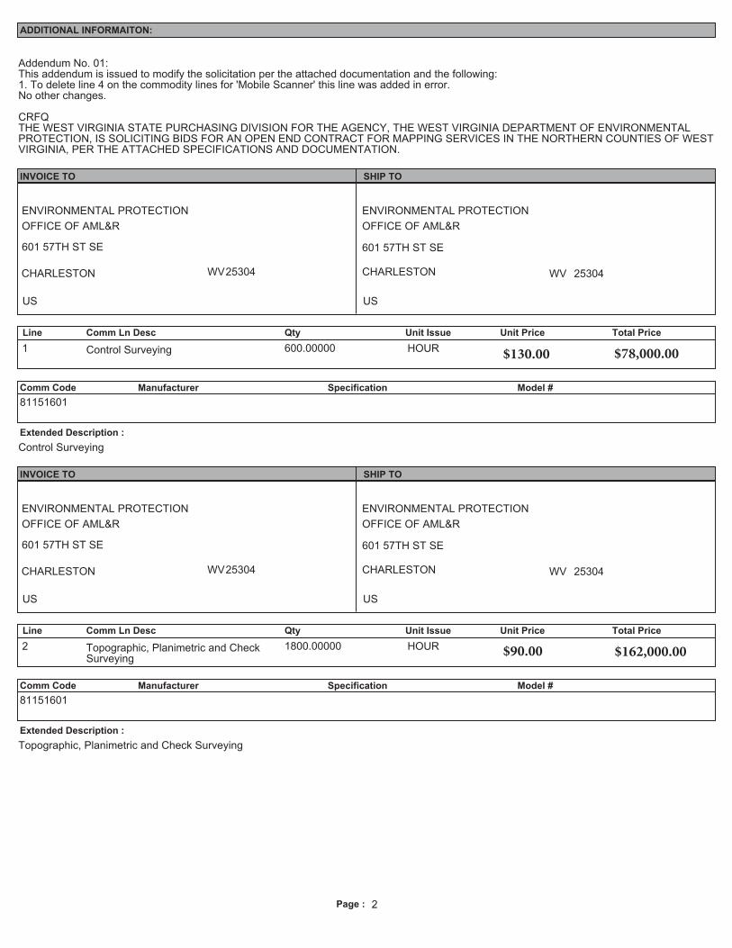
ADDITIONAL INFORMAITON:
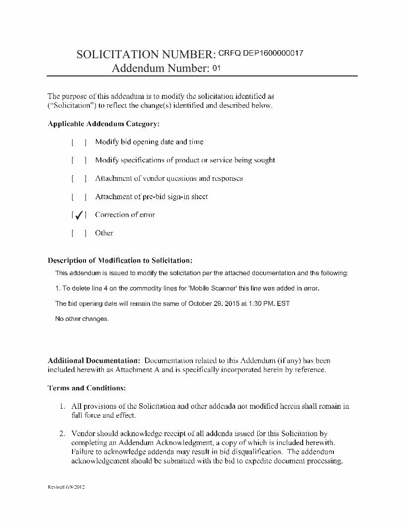
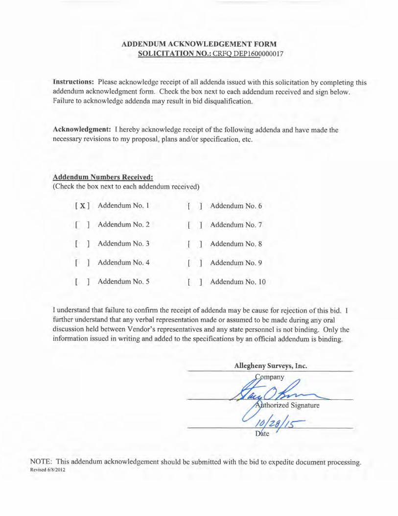
Addendum No. 01:This addendum is issued to modify the solicitation per the attached documentation and the following:1. To delete line 4 on the commodity lines for 'Mobile Scanner' this line was added in error.No other changes.
CRFQTHE WEST VIRGINIA STATE PURCHASING DIVISION FOR THE AGENCY, THE WEST VIRGINIA DEPARTMENT OF ENVIRONMENTALPROTECTION, IS SOLICITING BIDS FOR AN OPEN END CONTRACT FOR MAPPING SERVICES IN THE NORTHERN COUNTIES OF WESTVIRGINIA, PER THE ATTACHED SPECIFICATIONS AND DOCUMENTATION.
INVOICE TO SHIP TO
ENVIRONMENTAL PROTECTION
OFFICE OF AML&R
601 57TH ST SE
CHARLESTON WV25304
US
ENVIRONMENTAL PROTECTION
OFFICE OF AML&R
601 57TH ST SE
CHARLESTON WV 25304
US
Line Comm Ln Desc Qty Unit Issue Unit Price Total Price
1 Control Surveying 600.00000 HOUR
Comm Code Manufacturer Specification Model #
Extended Description :
81151601
Control Surveying
INVOICE TO SHIP TO
ENVIRONMENTAL PROTECTION
OFFICE OF AML&R
601 57TH ST SE
CHARLESTON WV25304
US
ENVIRONMENTAL PROTECTION
OFFICE OF AML&R
601 57TH ST SE
CHARLESTON WV 25304
US
Line Comm Ln Desc Qty Unit Issue Unit Price Total Price
2 Topographic, Planimetric and CheckSurveying
1800.00000 HOUR
Comm Code Manufacturer Specification Model #
Extended Description :
81151601
Topographic, Planimetric and Check Surveying
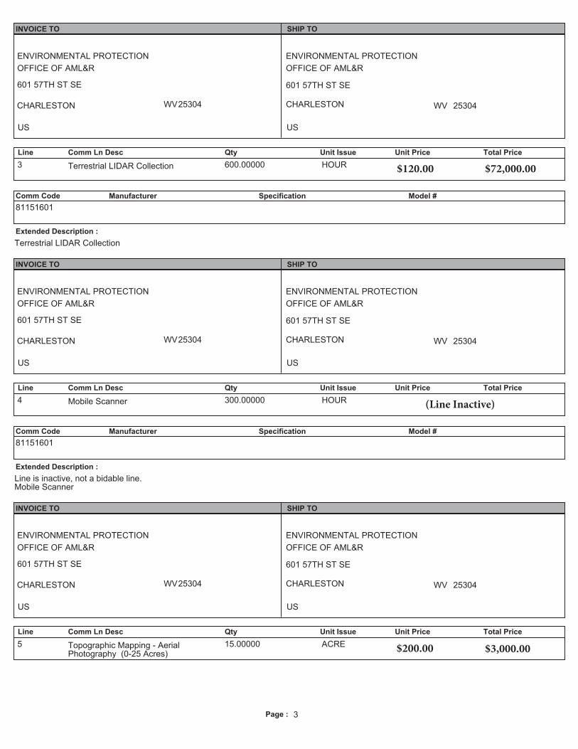
Page : 3
INVOICE TO SHIP TO
ENVIRONMENTAL PROTECTION
OFFICE OF AML&R
601 57TH ST SE
CHARLESTON WV25304
US
ENVIRONMENTAL PROTECTION
OFFICE OF AML&R
601 57TH ST SE
CHARLESTON WV 25304
US
Line Comm Ln Desc Qty Unit Issue Unit Price Total Price
3 Terrestrial LIDAR Collection 600.00000 HOUR
Comm Code Manufacturer Specification Model #
Extended Description :
81151601
Terrestrial LIDAR Collection
INVOICE TO SHIP TO
ENVIRONMENTAL PROTECTION
OFFICE OF AML&R
601 57TH ST SE
CHARLESTON WV25304
US
ENVIRONMENTAL PROTECTION
OFFICE OF AML&R
601 57TH ST SE
CHARLESTON WV 25304
US
Line Comm Ln Desc Qty Unit Issue Unit Price Total Price
4 Mobile Scanner 300.00000 HOUR
Comm Code Manufacturer Specification Model #
Extended Description :
81151601
Line is inactive, not a bidable line.Mobile Scanner
INVOICE TO SHIP TO
ENVIRONMENTAL PROTECTION
OFFICE OF AML&R
601 57TH ST SE
CHARLESTON WV25304
US
ENVIRONMENTAL PROTECTION
OFFICE OF AML&R
601 57TH ST SE
CHARLESTON WV 25304
US
Line Comm Ln Desc Qty Unit Issue Unit Price Total Price
5 Topographic Mapping - AerialPhotography (0-25 Acres)
15.00000 ACRE 200 3,000
Page : 4
Comm Code Manufacturer Specification Model #
Extended Description :
81151601
(including LIDAR Collections)
List only one rate for each category.
INVOICE TO SHIP TO
ENVIRONMENTAL PROTECTION
OFFICE OF AML&R
601 57TH ST SE
CHARLESTON WV25304
US
ENVIRONMENTAL PROTECTION
OFFICE OF AML&R
601 57TH ST SE
CHARLESTON WV 25304
US
Line Comm Ln Desc Qty Unit Issue Unit Price Total Price
6 Topographic Mapping - AerialPhotography (25-50 Acres)
30.00000 ACRE
Comm Code Manufacturer Specification Model #
Extended Description :
81151601
(including LIDAR Collections)
List only one rate for each category.
INVOICE TO SHIP TO
ENVIRONMENTAL PROTECTION
OFFICE OF AML&R
601 57TH ST SE
CHARLESTON WV25304
US
ENVIRONMENTAL PROTECTION
OFFICE OF AML&R
601 57TH ST SE
CHARLESTON WV 25304
US
Line Comm Ln Desc Qty Unit Issue Unit Price Total Price
7 Topographic Mapping - AerialPhotography (50-100 Acres)
75.00000 ACRE
Comm Code Manufacturer Specification Model #
Extended Description :
81151601
(including LIDAR Collections)
List only one rate for each category.
10 300
50 750
Page : 5
INVOICE TO SHIP TO
ENVIRONMENTAL PROTECTION
OFFICE OF AML&R
601 57TH ST SE
CHARLESTON WV25304
US
ENVIRONMENTAL PROTECTION
OFFICE OF AML&R
601 57TH ST SE
CHARLESTON WV 25304
US
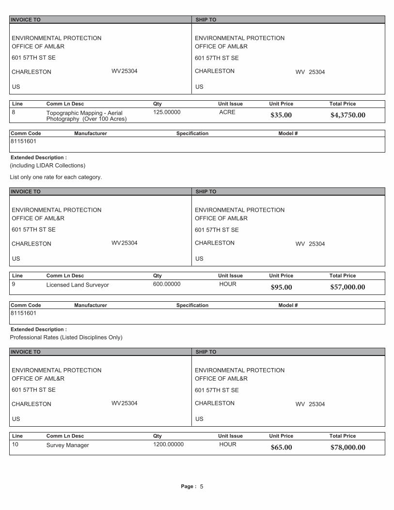
Line Comm Ln Desc Qty Unit Issue Unit Price Total Price
8 Topographic Mapping - AerialPhotography (Over 100 Acres)
125.00000 ACRE
Comm Code Manufacturer Specification Model #
Extended Description :
81151601
(including LIDAR Collections)
List only one rate for each category.
INVOICE TO SHIP TO
ENVIRONMENTAL PROTECTION
OFFICE OF AML&R
601 57TH ST SE
CHARLESTON WV25304
US
ENVIRONMENTAL PROTECTION
OFFICE OF AML&R
601 57TH ST SE
CHARLESTON WV 25304
US
Line Comm Ln Desc Qty Unit Issue Unit Price Total Price
9 Licensed Land Surveyor 600.00000 HOUR
Comm Code Manufacturer Specification Model #
Extended Description :
81151601
Professional Rates (Listed Disciplines Only)
INVOICE TO SHIP TO
ENVIRONMENTAL PROTECTION
OFFICE OF AML&R
601 57TH ST SE
CHARLESTON WV25304
US
ENVIRONMENTAL PROTECTION
OFFICE OF AML&R
601 57TH ST SE
CHARLESTON WV 25304
US
Line Comm Ln Desc Qty Unit Issue Unit Price Total Price
10 Survey Manager 1200.00000 HOUR
5 4,
Page : 6
Comm Code Manufacturer Specification Model #
Extended Description :
81151601
Professional Rates (Listed Disciplines Only)
INVOICE TO SHIP TO
ENVIRONMENTAL PROTECTION
OFFICE OF AML&R
601 57TH ST SE
CHARLESTON WV25304
US
ENVIRONMENTAL PROTECTION
OFFICE OF AML&R
601 57TH ST SE
CHARLESTON WV 25304
US
Line Comm Ln Desc Qty Unit Issue Unit Price Total Price
11 Mapping/CAD Technician 2400.00000 HOUR
Comm Code Manufacturer Specification Model #
Extended Description :
81151601
Professional Rates (Listed Disciplines Only)
INVOICE TO SHIP TO
ENVIRONMENTAL PROTECTION
OFFICE OF AML&R
601 57TH ST SE
CHARLESTON WV25304
US
ENVIRONMENTAL PROTECTION
OFFICE OF AML&R
601 57TH ST SE
CHARLESTON WV 25304
US
Line Comm Ln Desc Qty Unit Issue Unit Price Total Price
12 Travel Per Diem (Rate/Person)Day) 125.00000 EA
Comm Code Manufacturer Specification Model #
Extended Description :
81151601
Applicable to Survey Crews Only
SCHEDULE OF EVENTS
EventLine Event Date
1 Tech Question Deadline at 5:00PM, EST 2015-10-02

� � � � � � � � � � � �
� � � � � � � � � � � � � � � � � � � � � � � � � � � � � � � � � � � � � � � � � � � � � � � � � � � � � � � � � � � � � � � � � � ! " � # $ � % &' ( ) � � � � � � � � � � � * + � � � � � � � � � � � � � � , � ' � + � � � � � � � � � � � � � � � � � � � - � � - � � � . %/ 0 0 1 2 3 4 5 1 6 / 7 7 6 8 7 9 : ; 4 < 6 = > ? @ A� & B � � � � � - � � � � � � � � , � � � � � � � � � � �� & B � � � � � � � � � � � � � � � � � � � � � � � � � � � � � � � � � C � � � - � � � , � � � , �� & D � � � � � � � � � � C � � � � � E � � � � � � � � � � � � � � � � � � � �� & D � � � � � � � � � � � � � F - � � � � , � F � � � � � �� & G � � � � � � � � � � � � � � � �� & H � � �I 6 J 3 ? 2 0 < 2 > 8 > K L > 7 2 K 2 3 4 < 2 > 8 < > M > 1 2 3 2 < 4 < 2 > 8 A/ 7 7 2 < 2 > 8 4 1 I > 3 9 : 6 8 < 4 < 2 > 8 A N � � � � � � � � � � � � � � � � � � � � � � � � D � � � � � � � ' � � � � � + � � - � � �� � � � � � � � � � � . � � � � D � � � � � � � � D � � � � � � � � � � � � � � � � � � � � � � � � � � � � � � � � � � - � � � � � � � � � � %O 6 ? : J 4 8 7 ; > 8 7 2 < 2 > 8 J AP % D � � � � � C � � � � � � � � � � ) � � � � � � � � � � � � � � � � � � � � � � � � � � � � � � � � � � � � � � � � � � � � � � � � � � � � �� � � � � � � � � � � � � � � � � � %Q % R � � � � � � � � � � � � S � � . � � � , � � � � � � � � � � � � � � � � � � � � � � � � � � � � � � � � ) � � � � � � � � � � � - �� � � � � � � � � , � � D � � � � � � � D � S � � . � � � , � � � � " � � � � � � � . � � � � � � � � � � � � � � � . � � % � � � � � � � � � � S � � . � � � , � � � � � � � � � � � � � � � � � � � - � � � � � E � � � � � � � � � � � � % � � � � � � � � � �� � S � � . � � � , � � � � � � � � � � - � � � - � � � � � � . � � � � - � � � � � T � � � � � � � � � � � � � � � � � � � � � � � , %
U V W X Y Z [ \ ] ^ ^ ^ ^ ^ ^ \ _^ \
✔
` a b c d e e f g e h i b c b c c h f e j k i k e b l m j a f c k n b o b j d j b k g p f q j a f d j j d o a f e e k o h i f g j d j b k g d g e j a f l k n n k r b g s tu v ` k e f n f j f n b g f w k g j a f o k i i k e b j m n b g f c l k q x y k z b n f { o d g g f q x j a b c n b g f r d c d e e f e b g f q q k q v` a f z b e k p f g b g s e d j f r b n n q f i d b g j a f c d i f k l | o j k z f q } ~ � } � u � d j u t � � � y � � { `� k k j a f q o a d g s f c v
CERTIFICATE HOLDER
© 1988-2010 ACORD CORPORATION. All rights reserved.ACORD 25 (2010/05)
AUTHORIZED REPRESENTATIVE
CANCELLATION
DATE (MM/DD/YYYY)CERTIFICATE OF LIABILITY INSURANCE
LOCJECTPRO-POLICY
GEN'L AGGREGATE LIMIT APPLIES PER:
OCCURCLAIMS-MADE
COMMERCIAL GENERAL LIABILITY
GENERAL LIABILITY
PREMISES (Ea occurrence) $DAMAGE TO RENTEDEACH OCCURRENCE $
MED EXP (Any one person) $
PERSONAL & ADV INJURY $
GENERAL AGGREGATE $
PRODUCTS - COMP/OP AGG $
$RETENTIONDED
CLAIMS-MADE
OCCUR
$
AGGREGATE $
EACH OCCURRENCE $UMBRELLA LIAB
EXCESS LIAB
DESCRIPTION OF OPERATIONS / LOCATIONS / VEHICLES (Attach ACORD 101, Additional Remarks Schedule, if more space is required)
INSRLTR TYPE OF INSURANCE POLICY NUMBER
POLICY EFF(MM/DD/YYYY)
POLICY EXP(MM/DD/YYYY) LIMITS
WC STATU-TORY LIMITS
OTH-ER
E.L. EACH ACCIDENT
E.L. DISEASE - EA EMPLOYEE
E.L. DISEASE - POLICY LIMIT
$
$
$
ANY PROPRIETOR/PARTNER/EXECUTIVE
If yes, describe underDESCRIPTION OF OPERATIONS below
(Mandatory in NH)OFFICER/MEMBER EXCLUDED?
WORKERS COMPENSATIONAND EMPLOYERS' LIABILITY Y / N
AUTOMOBILE LIABILITY
ANY AUTOALL OWNED SCHEDULED
HIRED AUTOSNON-OWNED
AUTOS AUTOS
AUTOS
COMBINED SINGLE LIMIT
BODILY INJURY (Per person)
BODILY INJURY (Per accident)PROPERTY DAMAGE $
$
$$
THIS IS TO CERTIFY THAT THE POLICIES OF INSURANCE LISTED BELOW HAVE BEEN ISSUED TO THE INSURED NAMED ABOVE FOR THE POLICY PERIODINDICATED. NOTWITHSTANDING ANY REQUIREMENT, TERM OR CONDITION OF ANY CONTRACT OR OTHER DOCUMENT WITH RESPECT TO WHICH THISCERTIFICATE MAY BE ISSUED OR MAY PERTAIN, THE INSURANCE AFFORDED BY THE POLICIES DESCRIBED HEREIN IS SUBJECT TO ALL THE TERMS,EXCLUSIONS AND CONDITIONS OF SUCH POLICIES. LIMITS SHOWN MAY HAVE BEEN REDUCED BY PAID CLAIMS.
INSRADDL
WVDSUBR
N / A
$
$
(Ea accident)
(Per accident)
THIS CERTIFICATE IS ISSUED AS A MATTER OF INFORMATION ONLY AND CONFERS NO RIGHTS UPON THE CERTIFICATE HOLDER. THISCERTIFICATE DOES NOT AFFIRMATIVELY OR NEGATIVELY AMEND, EXTEND OR ALTER THE COVERAGE AFFORDED BY THE POLICIESBELOW. THIS CERTIFICATE OF INSURANCE DOES NOT CONSTITUTE A CONTRACT BETWEEN THE ISSUING INSURER(S), AUTHORIZEDREPRESENTATIVE OR PRODUCER, AND THE CERTIFICATE HOLDER.IMPORTANT: If the certificate holder is an ADDITIONAL INSURED, the policy(ies) must be endorsed. If SUBROGATION IS WAIVED, subject tothe terms and conditions of the policy, certain policies may require an endorsement. A statement on this certificate does not confer rights to thecertificate holder in lieu of such endorsement(s).
The ACORD name and logo are registered marks of ACORD
COVERAGES CERTIFICATE NUMBER: REVISION NUMBER:
INSURED
PHONE(A/C, No, Ext):
PRODUCER
ADDRESS:E-MAIL
FAX(A/C, No):
CONTACTNAME:
NAIC #
INSURER A :
INSURER B :
INSURER C :
INSURER D :
INSURER E :
INSURER F :
INSURER(S) AFFORDING COVERAGE
SHOULD ANY OF THE ABOVE DESCRIBED POLICIES BE CANCELLED BEFORETHE EXPIRATION DATE THEREOF, NOTICE WILL BE DELIVERED INACCORDANCE WITH THE POLICY PROVISIONS.
7/31/2015
The James B. Oswald Company1100 Superior Avenue, Suite 1500Cleveland OH 44114
Allegheny Surveys, Inc237 Birch River RdBirch River WV 26610-0438
Westfield National 24120
Vanetee Bayne216-839-2800 216-839-2815
TRANS-1
2058853631
A Y Y TRA1872479 8/5/2015 8/5/2016 1,000,000
1,000,000
5,000
1,000,000
2,000,000
2,000,000
X
X
X
X
AI Primary &
Non-Contributory
X XA Y Y
Y Y
X
X
X AI Primary
TRA1872479 8/5/2015 8/5/2016 1,000,000
A X
X
X
10,000
TRA1872479 8/5/2015 8/5/2016 4,000,000
4,000,000
Excludes Professional
Y Y
Additional Insured and Waiver of Subrogation as designated above is provided when required of the Named Insured by written contract oragreement.
SpecimenFor Purposes of EvidencingCoverage Only WV 26610-0438

CERTIFICATE HOLDER
© 1988-2010 ACORD CORPORATION. All rights reserved.ACORD 25 (2010/05)
AUTHORIZED REPRESENTATIVE
CANCELLATION
DATE (MM/DD/YYYY)CERTIFICATE OF LIABILITY INSURANCE
LOCJECTPRO-POLICY
GEN'L AGGREGATE LIMIT APPLIES PER:
OCCURCLAIMS-MADE
COMMERCIAL GENERAL LIABILITY
GENERAL LIABILITY
PREMISES (Ea occurrence) $DAMAGE TO RENTEDEACH OCCURRENCE $
MED EXP (Any one person) $
PERSONAL & ADV INJURY $
GENERAL AGGREGATE $
PRODUCTS - COMP/OP AGG $
$RETENTIONDED
CLAIMS-MADE
OCCUR
$
AGGREGATE $
EACH OCCURRENCE $UMBRELLA LIAB
EXCESS LIAB
DESCRIPTION OF OPERATIONS / LOCATIONS / VEHICLES (Attach ACORD 101, Additional Remarks Schedule, if more space is required)
INSRLTR TYPE OF INSURANCE POLICY NUMBER
POLICY EFF(MM/DD/YYYY)
POLICY EXP(MM/DD/YYYY) LIMITS
WC STATU-TORY LIMITS
OTH-ER
E.L. EACH ACCIDENT
E.L. DISEASE - EA EMPLOYEE
E.L. DISEASE - POLICY LIMIT
$
$
$
ANY PROPRIETOR/PARTNER/EXECUTIVE
If yes, describe underDESCRIPTION OF OPERATIONS below
(Mandatory in NH)OFFICER/MEMBER EXCLUDED?
WORKERS COMPENSATIONAND EMPLOYERS' LIABILITY Y / N
AUTOMOBILE LIABILITY
ANY AUTOALL OWNED SCHEDULED
HIRED AUTOSNON-OWNED
AUTOS AUTOS
AUTOS
COMBINED SINGLE LIMIT
BODILY INJURY (Per person)
BODILY INJURY (Per accident)PROPERTY DAMAGE $
$
$$
THIS IS TO CERTIFY THAT THE POLICIES OF INSURANCE LISTED BELOW HAVE BEEN ISSUED TO THE INSURED NAMED ABOVE FOR THE POLICY PERIODINDICATED. NOTWITHSTANDING ANY REQUIREMENT, TERM OR CONDITION OF ANY CONTRACT OR OTHER DOCUMENT WITH RESPECT TO WHICH THISCERTIFICATE MAY BE ISSUED OR MAY PERTAIN, THE INSURANCE AFFORDED BY THE POLICIES DESCRIBED HEREIN IS SUBJECT TO ALL THE TERMS,EXCLUSIONS AND CONDITIONS OF SUCH POLICIES. LIMITS SHOWN MAY HAVE BEEN REDUCED BY PAID CLAIMS.
INSRADDL
WVDSUBR
N / A
$
$
(Ea accident)
(Per accident)
THIS CERTIFICATE IS ISSUED AS A MATTER OF INFORMATION ONLY AND CONFERS NO RIGHTS UPON THE CERTIFICATE HOLDER. THISCERTIFICATE DOES NOT AFFIRMATIVELY OR NEGATIVELY AMEND, EXTEND OR ALTER THE COVERAGE AFFORDED BY THE POLICIESBELOW. THIS CERTIFICATE OF INSURANCE DOES NOT CONSTITUTE A CONTRACT BETWEEN THE ISSUING INSURER(S), AUTHORIZEDREPRESENTATIVE OR PRODUCER, AND THE CERTIFICATE HOLDER.IMPORTANT: If the certificate holder is an ADDITIONAL INSURED, the policy(ies) must be endorsed. If SUBROGATION IS WAIVED, subject tothe terms and conditions of the policy, certain policies may require an endorsement. A statement on this certificate does not confer rights to thecertificate holder in lieu of such endorsement(s).
The ACORD name and logo are registered marks of ACORD
COVERAGES CERTIFICATE NUMBER: REVISION NUMBER:
INSURED
PHONE(A/C, No, Ext):
PRODUCER
ADDRESS:E-MAIL
FAX(A/C, No):
CONTACTNAME:
NAIC #
INSURER A :
INSURER B :
INSURER C :
INSURER D :
INSURER E :
INSURER F :
INSURER(S) AFFORDING COVERAGE
SHOULD ANY OF THE ABOVE DESCRIBED POLICIES BE CANCELLED BEFORETHE EXPIRATION DATE THEREOF, NOTICE WILL BE DELIVERED INACCORDANCE WITH THE POLICY PROVISIONS.
7/31/2015
The James B. Oswald Company1100 Superior Avenue, Suite 1500Cleveland OH 44114
Allegheny Surveys, Inc237 Birch River RdBirch River WV 26610-0438
Beazley USA Services, Inc.
Vanetee Bayne216-839-2800 216-839-2815
TRANS-1
100134784
A Professional LiabilityClaims MadeRetro Date:08/05/03
V15V1T150801 8/5/2015 8/5/2016 Each ClaimAggregate
$1,000,000$1,000,000
N Y
Waiver of Subrogation as designated above is provided when required of the Named Insured by written contract or agreement.
SpecimenFor Purposes of EvidencingCoverage Only WV 26610-0438

CERTIFICATE OF LIABILITY INSURANCE
DATE (MM/DD/YYYY) 08/6/2015
THIS CERTIFICATE IS ISSUED AS A MATTER OF INFORMATION ONLY AND CONFERS NO RIGHTS UPON THE CERTIFICATE HOLDER. THIS CERTIFICATE DOES NOT AFFIRMATIVELY OR NEGATIVELY AMEND, EXTEND OR ALTER THE COVERAGE AFFORDED BY THE POLICIES BELOW. THIS CERTIFICATE OF INSURANCE DOES NOT CONSTITUTE A CONTRACT BETWEEN THE ISSUING INSURER(S), AUTHORIZED REPRESENTATIVE OR PRODUCER, AND THE CERTIFICATE HOLDER. IMPORTANT: If the certificate holder is an ADDITIONAL INSURED, the policy(ies) must be endorsed. If SUBROGATION IS WAIVED, subject to the terms and conditions of the policy, certain policies may require an endorsement. A statement on this certificate does not confer rigths to the certificate holder in lieu of such endorsement(s).
PRODUCER AmWINS Program Underwriters, Inc. 214 Senate Avenue Suite 201 Camp Hill, PA 17011
CONTACT NAME: Jodie Schock PHONE (A/C, No, Ext): 717.214.7583 FAX
(A/C, No): 717.214.2801 E-MAIL ADDRESS: [email protected]
INSURER(S) AFFORDING COVERAGE NAIC # INSURER A: Brickstreet Mutual Insurance Company 15762
INSURED Allegheny Surveys Inc 237 Birch River Road Birch River, WV 26610
INSURER B: INSURER C: INSURER D: INSURER E: INSURER F:
COVERAGES CERTIFICATE NUMBER: REVISION NUMBER: THIS IS TO CERTIFY THAT THE POLICIES OF INSURANCE LISTED BELOW HAVE BEEN ISSUED TO THE INSURED NAMED ABOVE FOR THE POLICY PERIOD INDICATED. NOTWITHSTANDING ANY REQUIREMENT, TERM OR CONDITION OF ANY CONTRACT OR OTHE DOCUMENT WITH RESPECT TO WHICH THIS CERTIFICATE MAY BE ISSUED OR MAY PERTAIN, THE INSURANCE AFFORDED BY THE POLICIES DESCRIBED HEREIN IS SUBJECT TO ALL THE TERMS, EXCLUSIONS AND CONDITIONS OF SUCH POLICIES. LIMITS SHOWN MAY HAVE BEEN REDUCED BY PAID CLAIMS. INSR LTR TYPE OF INSURANCE
ADDL INSR
SUBR WVD POLICY NUMBER
POLICY EFF (MM/DD/YYYY)
POLCIY EXP (MM/DD/YYYY) LIMITS
GENERAL LIABILITY EACH OCCURRENCE $ COMMERCIAL GENERAL LIABILITY
DAMAGE TO RENTED PREMISES (Ea occurrence) $
CLAIMS-MADE MED EXP (Any one person) $ PERSONAL & ADV INJURY $ GENERAL AGGREGATE $ GEN’L AGGREGATE LIMIT APPLIES PER: PRODUCTS - COMP/OP AGG $ POLICY PRO-
JECT $
AUTOMOBILE LIABILITY COMBINED SINGLE LIMIT (Ea accident) $
ANY AUTO BODILY INJURY (Per Person) $ ALL OWNED
AUTOS SCHEDULED AUTOS BODILY INJURY (Per accident) $
HIRED AUTOS NON-OWNED AUTOS
PROPERTY DAMAGE (Per accident) $
UMBRELLA LIAB OCCUR EACH OCCURRENCE $ EXCESS LIAB CLAIMS-MADE AGGREGATE $ DED RETENTION $ $
A WORKERS COMPENSATION AND EMPLOYERS’ LIABILITY ANY PROPRIETOR/PARTNER/EXECUTIVE OFFICE/MEMBER EXCLUDED? (Mandatory in NH) If yes, describe under DESCRIPTION OF OPERATION below
Y/N
WCB1021532 8/5/2015 8/5/2016 X WC STATU-TORY LIMITS X
OTH-ER
Y Y E.L. EACH ACCIDENT $1,000,000
E.L. DISEASE - EA EMPLOYEE $1,000,000 E.L. DISEASE - POLICY LIMIT $1,000,000
DESCRIPTION OF OPERATIONS / LOCATIONS / VEHICLES (Attach ACORD 101, Additional Remarks Schedule, if more space is required)
Blanket Waiver of Subrogation apples in the state of WV. Broad Form Employers’ Liability applies in the state of WV. Federal Black Lung coverage applies in the state of WV.
CERTIFICATE HOLDER CANCELLATION
Evidence of Workers’ Compensation coverage for Virginia, Kentucky, West Virginia, Tennessee and Pennsylvania.
SHOULD ANY OF THE ABOVE DESCRIBED POLICIES BE CANCELLED BEFORE THE EXPIRATION DATE THEREOF, NOTICE WILL BE DELIVERED IN ACCORDANCE WITH THE POLICY PROVISIONS.
AUTHORIZED REPRESENTATIVE
© 1988-2010 ACORD CORPORATION. All rights reserved. ACORD 25 (2010/05) The ACORD name and logo are registered marks of ACORD
land development & engineering design solutions
1 - 8 0 0 - 4 8 2 - 8 6 0 6 A L L E G H E N Y S U R V E Y S . C O M
Company Overview . . . . . . . . . . . . . . . . . . . . . . . . . . . . . . . Section 1
Construction Surveys. . . . . . . . . . . . . . . . . . . . . . . . . . . . . . Section 2
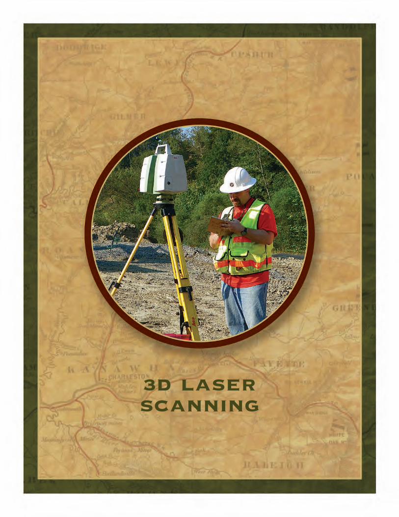
3D Laser Scanning. . . . . . . . . . . . . . . . . . . . . . . . . . . . . . . . Section 3
Real Estate Surveys . . . . . . . . . . . . . . . . . . . . . . . . . . . . . . . Section 4
Natural Resource Surveys . . . . . . . . . . . . . . . . . . . . . . . . . . Section 5
GIS Services . . . . . . . . . . . . . . . . . . . . . . . . . . . . . . . . . . . . . Section 6
GPS Surveys . . . . . . . . . . . . . . . . . . . . . . . . . . . . . . . . . . . . . Section 7
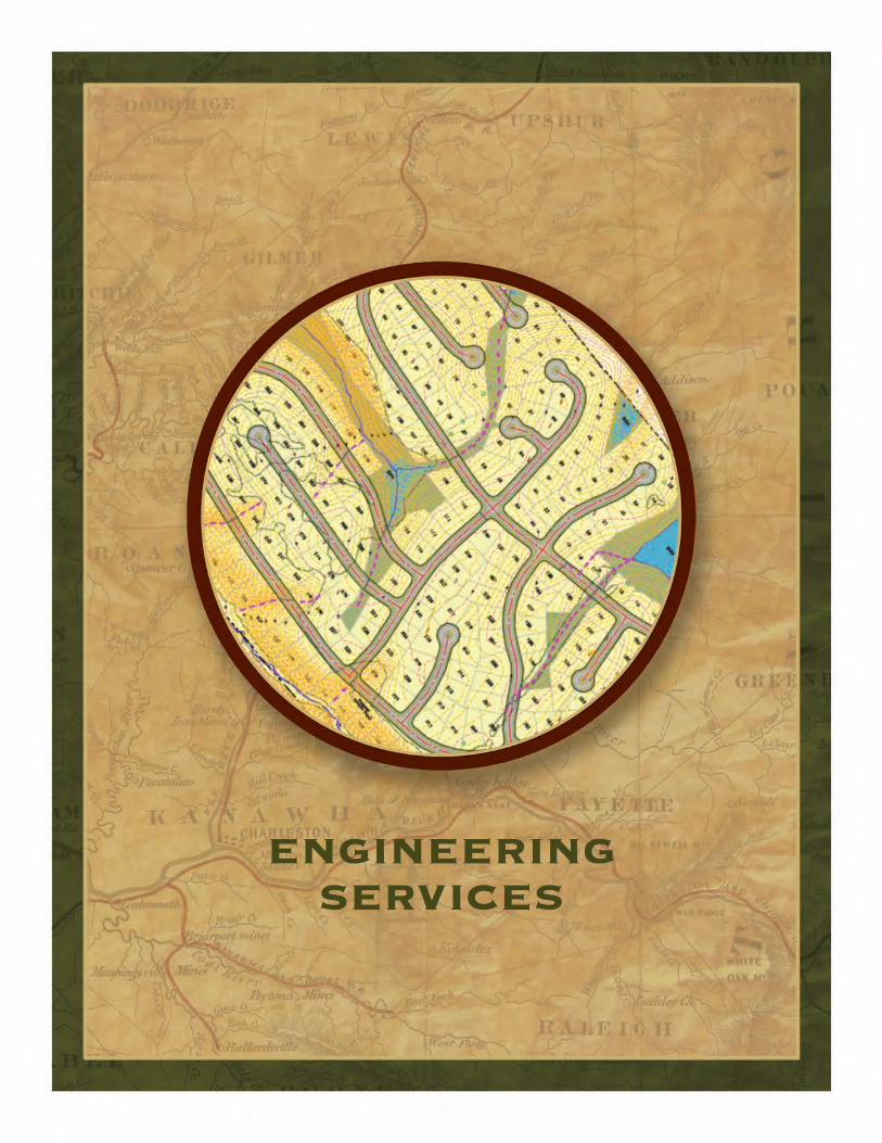
Engineering Services . . . . . . . . . . . . . . . . . . . . . . . . . . . . . . Section 8
Case Studies . . . . . . . . . . . . . . . . . . . . . . . . . . . . . . . . . . . . . Section 9
Our Team . . . . . . . . . . . . . . . . . . . . . . . . . . . . . . . . . . . . . . Section 10
Equipment and Software . . . . . . . . . . . . . . . . . . . . . . . . . . Section 11
table of contents
1 - 8 0 0 - 4 8 2 - 8 6 0 6 A L L E G H E N Y S U R V E Y S . C O M
S E C T I O N 1
company overview
Originally founded in 1988 in Birch River, West Virginia as Allegheny Land Surveying, Allegheny Surveys, Inc. (incorporated in 1994) is a land-surveying rm that for many years provided the coal and timber industries with their surveying and mapping needs.
�e rm specializes in large boundary surveys, often of several thousand acres, underground and surface mine surveys, construction surveys and topographic surveying. It has undertaken many large projects, including a 27,000 acre boundary survey, and a 45,000 acre boundary with numerous long-term clients who have remained faithful to it for years. In 1995, the rm undertook to learn to utilize GPS technology in its services, and has become a leader in that eld since that time. It has performed extensive GPS control surveys all over West Virginia and also in Kentucky, Indiana, Illinois and Maryland.
�e owner of the rm is Marshall Robinson, who has been a licensed professional surveyor in West Virginia since 1988, in Virginia, Kentucky and Ohio since 2005 and in Pennsylvania since 2009. Originally appointed by Governor Underwood to serve on the State Board of Examiners of Land Surveyors in 2000, he was re-appointed by Governor Wise in 2003 to serve a second three-year term. He is a former member of the Board of Directors of the West Virginia Association of Land
Surveyors and served as its president in 1993. He is currently President-elect and, will take o�ce as President in February, 2014. He has extensive experience in mining and construction surveys, GPS control surveys, well location surveys and, especially, boundary surveys. He has given numerous seminars on boundary con�ict and resolution, right-of-way and easement issues and GPS
applications to land surveying.
Allegheny Surveys currently has sixty employees,
in four o�ces, and the capacity to field thirteen
crews. It employs thirteen licensed Professional Surveyors and a GIS Analyst.
In 2003, the company expanded
by establishing an o�ce in Weston, in northern
West Virginia. In June of 2008, this o�ce was moved farther north, to
Bridgeport, to better accommodate its client base. In June of 2011, this o�ce moved into a new 2500 sq. ft. o�ce on �ompson Drive.
In May of 2008, Allegheny Surveys purchased the assets and hired all eleven employees of Lincoln Land Consultants, a surveying rm located near Alum Creek, just a few minutes southwest of the State Capitol in Charleston. �is became the Alum Creek O�ce of Allegheny Surveys. It was awarded, in the summer of 2011, a 5-year small business contract with the Corps of Engineers.

1 - 8 0 0 - 4 8 2 - 8 6 0 6 A L L E G H E N Y S U R V E Y S . C O M
S E C T I O N 1
company overview continued
On December 23 of 2011, Marshall W. Robinson, President and sole shareholder of Allegheny Surveys, Inc. formed Trans-Allegheny Holdings, LLC, and became its single member and transferred all of the stock of Allegheny Surveys, Inc. to it on December 31, 2011. On the same day, Trans-Allegheny Holdings, LLC purchased a majority of the stock in Hornor Brothers Engineering of Clarksburg. Trey and John Hornor, great-grandsons of one of the two brothers that founded the rm in 1902, retain substantial interest in the company, and retain their respective positions of President and Survey Manager.
On January 1, 2012, Trans-Allegheny Holdings, LLC conveyed 16% of the total stock of Allegheny Surveys, Inc. to six senior Professional Surveyors: Ben Singleton, PS, Dwayne Hall, PS, Stacey Brown, PS, Dwayne Matheny, PS, Damon Wilkewitz, PS and David King, PS.
From a corporate perspective, this is a lot of “high end” activity. From a personal perspective, the acquisition of Hornor Brothers brings a group of talented stable and highly regarded professionals under the same roof
as Allegheny Surveys. Trey, John and Marshall operate professionally from and are driven by the same values that have motivated Marshall and the Senior Professionals of Allegheny Surveys and brought that rm to its current position of prominence. We believe that the merging of professional talents and personalities will greatly enhance both rms and their service to our clients.
In May 2014, Allegheny Surveys opened a new o�ce at 401 South Fairfax Blvd., Ranson, WV. With theaddition of Karen K. Brill, PS, Lisa McCauley, PE, and R. Michael Shepp, PS we add over 35 years of engineering and surveying experience to our company.
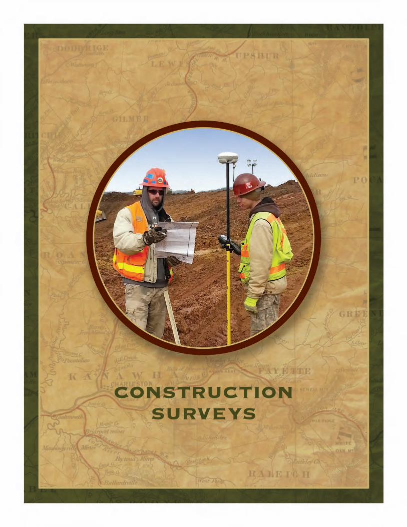
constructionsurveys
1 - 8 0 0 - 4 8 2 - 8 6 0 6 A L L E G H E N Y S U R V E Y S . C O M
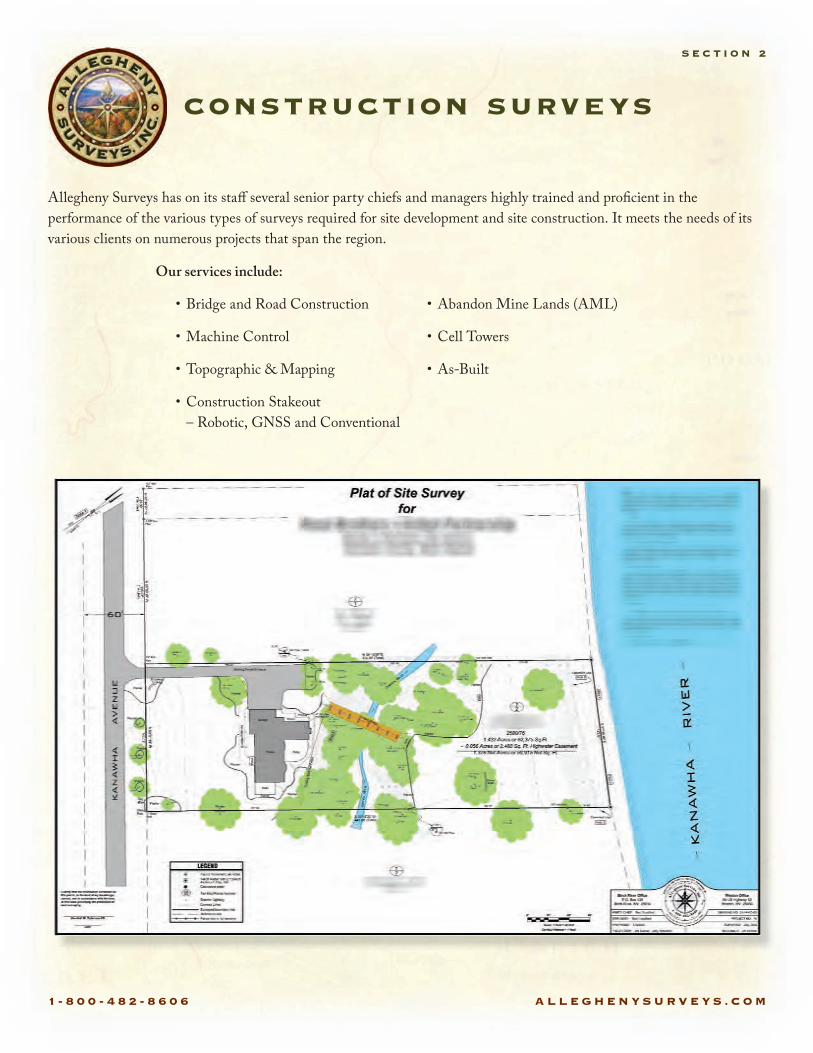
construction surveys
S E C T I O N 2
Allegheny Surveys has on its sta§ several senior party chiefs and managers highly trained and pro cient in the performance of the various types of surveys required for site development and site construction. It meets the needs of its various clients on numerous projects that span the region.
Our services include:
• Bridge and Road Construction
• Machine Control
• Topographic & Mapping
• Construction Stakeout – Robotic, GNSS and Conventional
• Abandon Mine Lands (AML)
• Cell Towers
• As-Built
3d laserscanning
1 - 8 0 0 - 4 8 2 - 8 6 0 6 A L L E G H E N Y S U R V E Y S . C O M
3d laser scanning
S E C T I O N 3
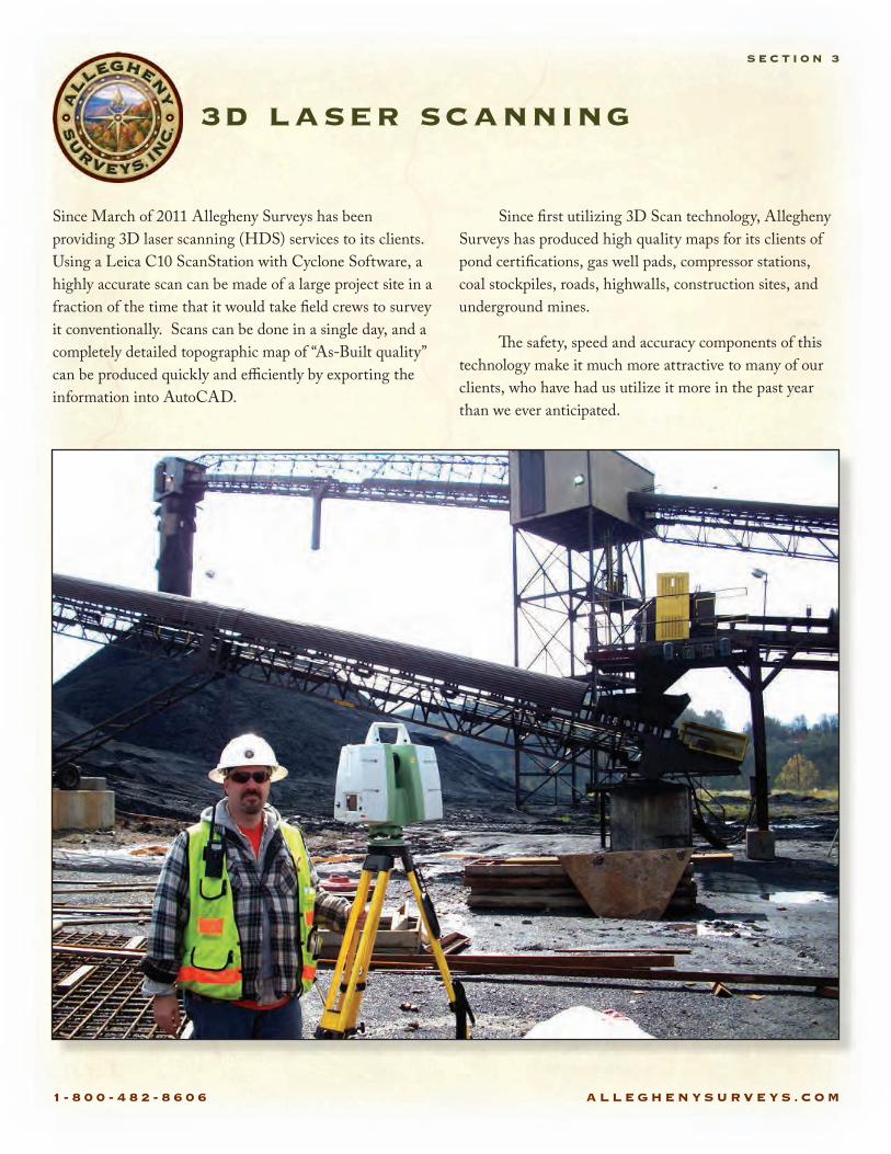
Since March of 2011 Allegheny Surveys has been providing 3D laser scanning (HDS) services to its clients. Using a Leica C10 ScanStation with Cyclone Software, a highly accurate scan can be made of a large project site in a fraction of the time that it would take eld crews to survey it conventionally. Scans can be done in a single day, and a completely detailed topographic map of “As-Built quality” can be produced quickly and e�ciently by exporting the information into AutoCAD.
Since rst utilizing 3D Scan technology, Allegheny Surveys has produced high quality maps for its clients of pond certi cations, gas well pads, compressor stations, coal stockpiles, roads, highwalls, construction sites, and underground mines.
�e safety, speed and accuracy components of this technology make it much more attractive to many of our clients, who have had us utilize it more in the past year than we ever anticipated.
1 - 8 0 0 - 4 8 2 - 8 6 0 6 A L L E G H E N Y S U R V E Y S . C O M
Site Survey using 3D Laser Scanning Technology
S E C T I O N 3
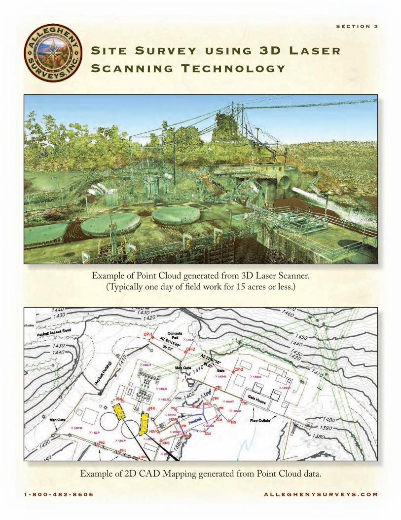
Example of Point Cloud generated from 3D Laser Scanner.(Typically one day of �eld work for 15 acres or less.)
Example of 2D CAD Mapping generated from Point Cloud data.

real estatesurveys
1 - 8 0 0 - 4 8 2 - 8 6 0 6 A L L E G H E N Y S U R V E Y S . C O M
real estate surveys
S E C T I O N 4
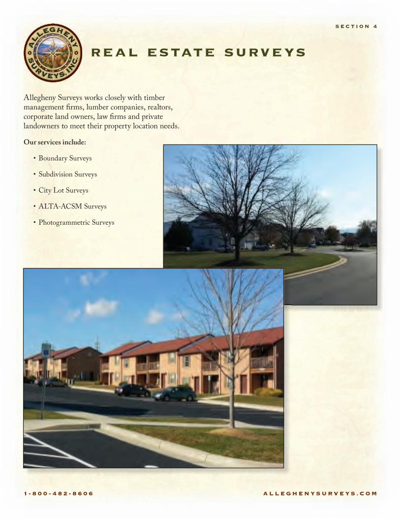
Allegheny Surveys works closely with timber management rms, lumber companies, realtors, corporate land owners, law rms and private landowners to meet their property location needs.
Our services include:
• Boundary Surveys
• Subdivision Surveys
• City Lot Surveys
• ALTA-ACSM Surveys
• Photogrammetric Surveys

natural resourcesurveys
1 - 8 0 0 - 4 8 2 - 8 6 0 6 A L L E G H E N Y S U R V E Y S . C O M
natural resource surveys
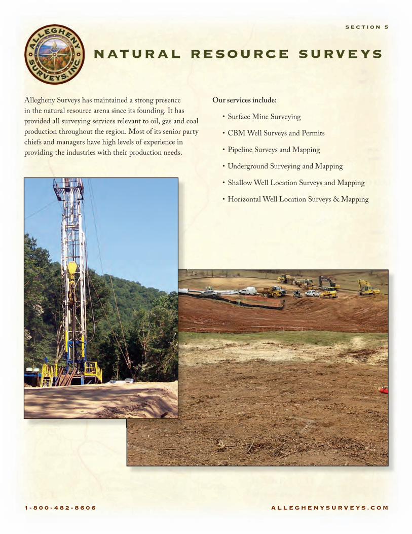
S E C T I O N 5
Allegheny Surveys has maintained a strong presence in the natural resource arena since its founding. It has provided all surveying services relevant to oil, gas and coal production throughout the region. Most of its senior party chiefs and managers have high levels of experience in providing the industries with their production needs.
Our services include:
• Surface Mine Surveying
• CBM Well Surveys and Permits
• Pipeline Surveys and Mapping
• Underground Surveying and Mapping
• Shallow Well Location Surveys and Mapping
• Horizontal Well Location Surveys & Mapping
gis services

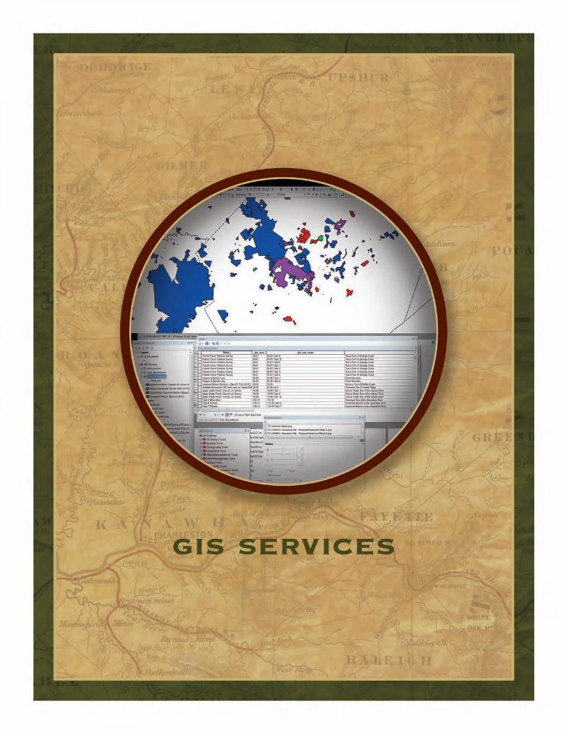
1 - 8 0 0 - 4 8 2 - 8 6 0 6 A L L E G H E N Y S U R V E Y S . C O M
gis services
S E C T I O N 6
From data management to full scale GIS analysis we can o§er multiple GIS (Geographic Information Systems) services. We utilize the power of ArcGIS, AutoCAD, and other applicable software to build and manage scalable spatial information systems. Using up-to-date
reference material such as high resolution aerial imagery, in conjunction with unequalled survey grade data, we are able to provide custom GIS solutions to our clients. �ese services are o§ered as a standalone service or they can be incorporated into our forestry and surveying services.
gps surveys
1 - 8 0 0 - 4 8 2 - 8 6 0 6 A L L E G H E N Y S U R V E Y S . C O M
gps surveys
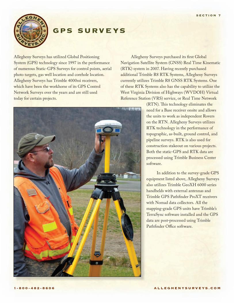
S E C T I O N 7
Allegheny Surveys has utilized Global Positioning System (GPS) technology since 1997 in the performance of numerous Static-GPS Surveys for control points, aerial photo targets, gas well location and corehole location. Allegheny Surveys has Trimble 4000ssi receivers, which have been the workhorse of its GPS Control Network Surveys over the years and are still used today for certain projects.
Allegheny Surveys purchased its rst Global Navigation Satellite System (GNSS) Real Time Kinematic (RTK) system in 2007. Having recently purchased additional Trimble R8 RTK Systems, Allegheny Surveys currently utilizes Trimble R8 GNSS RTK Systems. One of these RTK Systems also has the capability to utilize the West Virginia Division of Highways (WVDOH) Virtual Reference Station (VRS) service, or Real Time Network
(RTN). �is technology eliminates the need for a Base receiver onsite and allows the units to work as independent Rovers on the RTN. Allegheny Surveys utilizes RTK technology in the performance of topographic, as-built, ground control, and pipeline surveys. RTK is also used for construction stakeout on various projects. Both the static-GPS and RTK data are processed using Trimble Business Center software.
In addition to the survey-grade GPS equipment listed above, Allegheny Surveys also utilizes Trimble GeoXH 6000 series handhelds with external antennas and Trimble GPS Path nder ProXT receivers with Nomad data collectors. All the mapping-grade GPS units have Trimble’s TerraSync software installed and the GPS data are post-processed using Trimble Path nder O�ce software.
1 - 8 0 0 - 4 8 2 - 8 6 0 6 A L L E G H E N Y S U R V E Y S . C O M
engineering services
1 - 8 0 0 - 4 8 2 - 8 6 0 6 A L L E G H E N Y S U R V E Y S . C O M
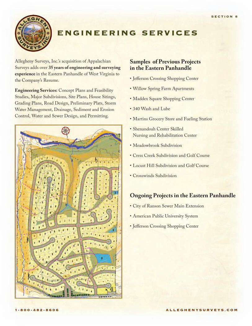
Allegheny Surveys, Inc.’s acquisition of Appalachian Surveys adds over 35 years of engineering and surveying experience in the Eastern Panhandle of West Virginia to the Company’s Resume.
Engineering Services: Concept Plans and Feasibility Studies, Major Subdivisions, Site Plans, House Sitings, Grading Plans, Road Design, Preliminary Plats, Storm Water Management, Drainage, Sediment and Erosion Control, Water and Sewer Design, and Permitting.
Samples of Previous Projects in the Eastern Panhandle
• Je§erson Crossing Shopping Center
• Willow Spring Farm Apartments
• Maddex Square Shopping Center
• 340 Wash and Lube
• Martins Grocery Store and Fueling Station
• Shenandoah Center Skilled Nursing and Rehabilitation Center
• Meadowbrook Subdivision
• Cress Creek Subdivision and Golf Course
• Locust Hill Subdivision and Golf Course
• Crosswinds Subdivision
Ongoing Projects in the Eastern Panhandle
• City of Ranson Sewer Main Extension
• American Public University System
• Je§erson Crossing Shopping Center
engineering services
S E C T I O N 8

1 - 8 0 0 - 4 8 2 - 8 6 0 6 A L L E G H E N Y S U R V E Y S . C O M
case studies
S E C T I O N 9
I. Beech Ridge Wind Farm
1. Client: Invenergy, LLC
2. Location: Beech Ridge, western Greenbrier County, West Virginia
3. Contract awarded: December 1, 2006
4. Project cost: $303,000
5. Project Description:
�e location by survey of a 27,000 acre lease area that included the delineation of 27 miles of interior and exterior conventionally surveyed boundary lines as well as the survey of a 15 mile long power line easement. �is easement was 100’ in width and required the de ning and certi cation of all boundaries that the power line crossed. It also required the staking of all powerline de�ections (PI’s) and the �agging of clearing limits. Both the Lease survey and the transmission line easement survey were performed as ALTA-ACSM land title surveys. �is
meant that the entire survey had to be performed to rigid positional tolerances and required the location of numerous features encountered during the survey.
A GPS network of 32 control points were placed along the perimeter of the lease and along the power line easement. �is network was tied to the National Geodetic Survey’s High Accuracy Reference Network (HARN) using four dual-frequency survey-grade GPS receivers.
�e eld work commenced on this project in December of 2006, was idled from mid-January until mid-March because of heavy snow throughout the project site, and was eld-completed in early May. Two crews worked on the project for a total of 3 ½ months. �e ALTA plats were submitted to the client and the title insurance company for review at the end of May, and were nalized and formally submitted in July of 2007.
Example plat on next page (Image quality reduced)

1-8
00
-4
82
-8
60
6
AL
LE
GH
EN
YS
UR
VE
YS
.CO
M
1 - 8 0 0 - 4 8 2 - 8 6 0 6 A L L E G H E N Y S U R V E Y S . C O M
II. Powellton 45,000 acre boundary survey
1. Client: Pardee and Curtin Realty, LLC
2. Location: Kanawha and Fayette Counties, West Virginia
3. Contract awarded: Fall, 2003
4. Project Cost: $663,000
5. Project Description:
�is survey was performed to monument, mark and paint and prepare survey documentation relevant to the boundaries of a 45,000 acre tract of fee property in some of the most rugged terrain that West Virginia has to o§er. �e coordinate base for this project was a project datum derived from the West Virginia Coordinate System of
1983 and tied to the National Geodetic Surveys HARN, as determined by a GPS network consisting 32 GPS control points that were observed in October of 2003. �e eld traverse was started the next month. �e work progressed in accordance with annual budgeted allocations for the project. A survey of this magnitude required careful coordination and the ability to move people in and out of the project as needed. Speci c needs of the client prompted the need to address speci c areas on the boundary at di§erent times. �e project was substantially completed in 2009 with smaller issues projecting the nal completion of the survey to the Spring of 2013.
Example Property Map on next page (Image quality reduced)
case studies continued
S E C T I O N 9

1 - 8 0 0 - 4 8 2 - 8 6 0 6 A L L E G H E N Y S U R V E Y S . C O M
1 - 8 0 0 - 4 8 2 - 8 6 0 6 A L L E G H E N Y S U R V E Y S . C O M
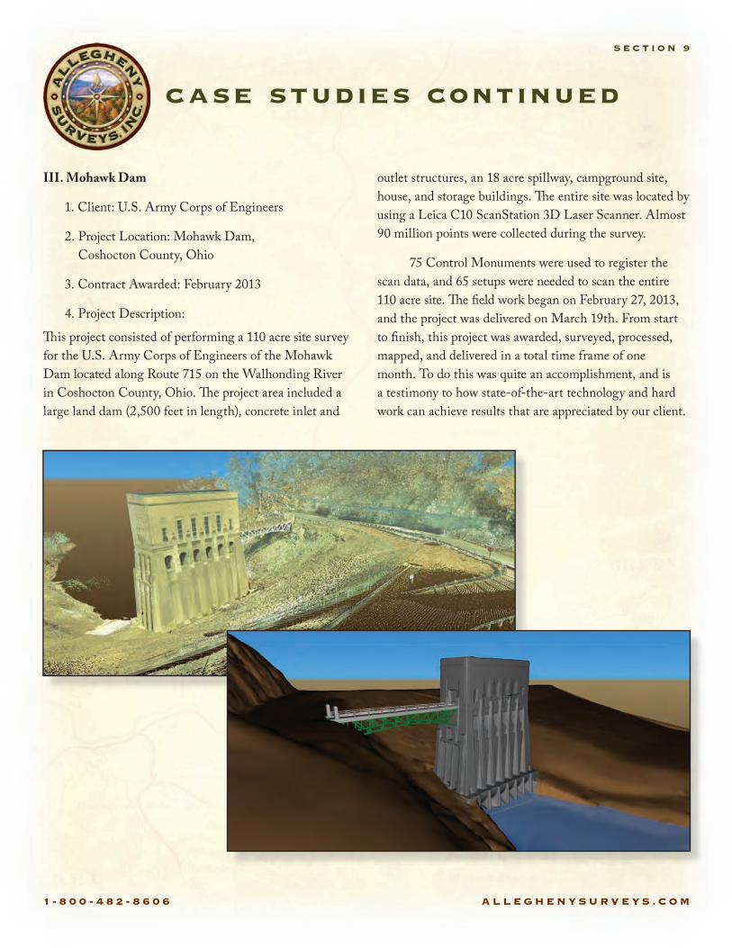
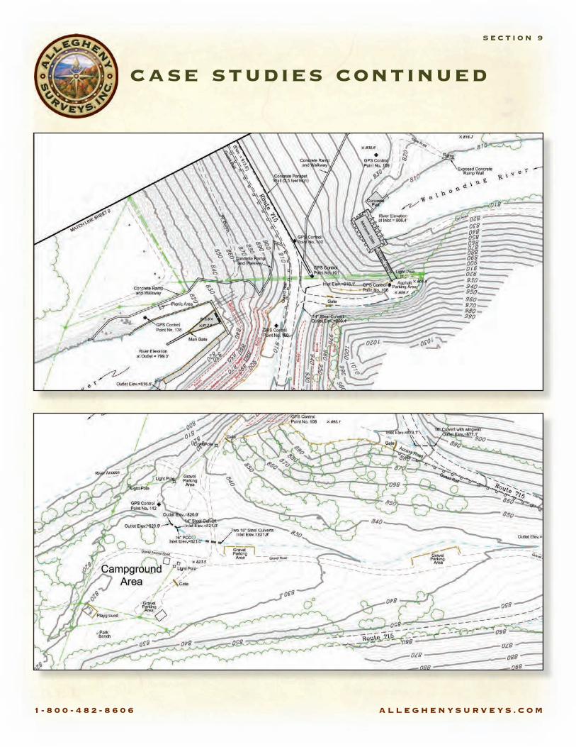
III. Mohawk Dam
1. Client: U.S. Army Corps of Engineers
2. Project Location: Mohawk Dam, Coshocton County, Ohio
3. Contract Awarded: February 2013
4. Project Description:
�is project consisted of performing a 110 acre site survey for the U.S. Army Corps of Engineers of the Mohawk Dam located along Route 715 on the Walhonding River in Coshocton County, Ohio. �e project area included a large land dam (2,500 feet in length), concrete inlet and
outlet structures, an 18 acre spillway, campground site, house, and storage buildings. �e entire site was located by using a Leica C10 ScanStation 3D Laser Scanner. Almost 90 million points were collected during the survey.
75 Control Monuments were used to register the scan data, and 65 setups were needed to scan the entire 110 acre site. �e eld work began on February 27, 2013, and the project was delivered on March 19th. From start to nish, this project was awarded, surveyed, processed, mapped, and delivered in a total time frame of one month. To do this was quite an accomplishment, and is a testimony to how state-of-the-art technology and hard work can achieve results that are appreciated by our client.
case studies continued
S E C T I O N 9
1 - 8 0 0 - 4 8 2 - 8 6 0 6 A L L E G H E N Y S U R V E Y S . C O M
case studies continued
S E C T I O N 9

1 - 8 0 0 - 4 8 2 - 8 6 0 6 A L L E G H E N Y S U R V E Y S . C O M
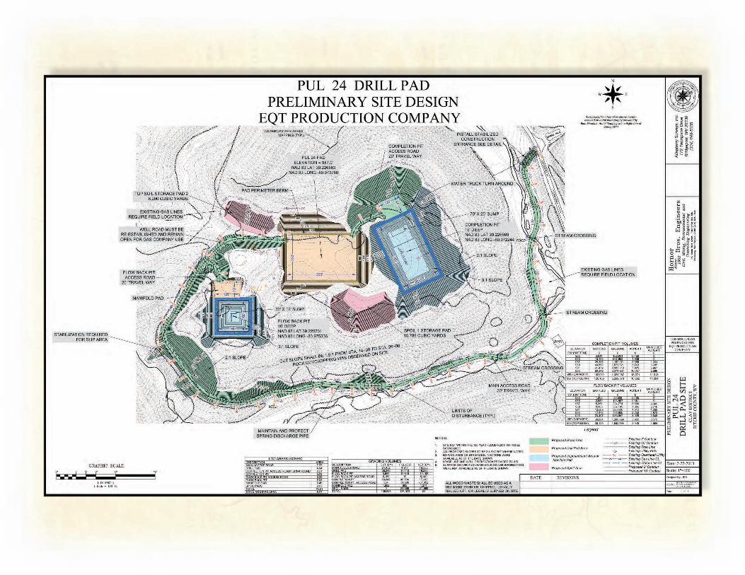
IV. Antero
1. Client: Antero Resources Corporation
2. Project Location: North Central West Virginia to Southeastern Ohio
3. Contract Awarded: January 2009
4. Project Description:
�is contract started in January 2009 which consisted of survey and mapping for proposed drill pad & frac pit locations, preparation of proposed horizontal well permit packages and the mapping of preconstruction and asbuilt pipeline surveys for Antero’s gathering system. Since 2009 we have surveyed and mapped approximately 230 horizontal well permit packages located in Harrison, Doddridge, Tyler and Ritchie Counties and approximately 150 miles of gathering pipelines.
In January 2012 we started o§ering engineering services for the construction of drill pad & freshwater impoundments through our sister company, Hornor Brothers Engineers, and our sub-consultants, L & W Enterprises. Over the past year and a half we have aided in the design of 100 pad/impoundment sites in North Central West Virginia and recently in Southeastern Ohio.
V. EQT
1. Client: EQT Production & EQT Midstream and Equitrans
2. Location: Northeastern West Virginia & Southwest Pennsylvania
3. Contract awarded: 2003
4. Project Description:
In 2003, Allegheny Surveys began locating and mapping hundreds of miles of existing pipeline for EQT Midstream and Equitrans to incorporate legacy networks into EQT’s database. It also performed pre-construction pipeline surveying and mapping on various lines in Northern West Virginia. In 2007, Allegheny Surveys began preparatory well “plugging” and well re-completion packages for EQT Production as well as roads and stream crossing permits. Shallow well permit packages soon followed, and in 2010 Allegheny Surveys began preparing Horizontal Well Permit packages for EQT in Wetzel County, WV. �is past year, its volume of work for EQT was expanded, and it currently provides more surveying and mapping services related to Marcellus development in West Virginia than any other surveying or engineering rm.
case studies continued
S E C T I O N 9

1 - 8 0 0 - 4 8 2 - 8 6 0 6 A L L E G H E N Y S U R V E Y S . C O M
1-8
00
-4
82
-8
60
6
AL
LE
GH
EN
YS
UR
VE
YS
.CO
M
1 - 8 0 0 - 4 8 2 - 8 6 0 6 A L L E G H E N Y S U R V E Y S . C O M
VI. US Army Corps of Engineers (USACE) – Great Lakes and Ohio River Division
1. Client: USACE
2. Project Location: Huntington District
3. Contract Awarded: March 2012
4: Project Cost: Not to exceed $2,500,000
5. Project Description:
Surveying and Engineering services which include horizontal and vertical control surveys, geodetic surveys, High De nition Scanning (HDS) surveys, real property surveys of Government-owned land tracts, such as levees, reservoirs, or dredge disposal areas, structural deformation studies, construction layout surveys, land surveys, surface mine and underground mine surveys, route surveys, quantity surveys, hydrographic surveys and Hazardous and Toxic Radioactive Waste (HTRW) surveys. �e project also includes establishing or re-establishing corners, monuments and boundary lines, or for the purpose of describing xed improvements, or platting or dividing parcels. �ese projects are being performed as necessary to support engineering studies to include design and construction, planning, operation and maintenance of navigation and �ood control projects, real estate and emergency management activities.
1) Deformation monitoring capabilities utilizing least squares adjustments to analyze survey measurements for accuracy and monitor movement of large structures.
2) Cadastral surveying capabilities to reestablish, monument and sub-divide parcels, easements and right-of- ways in accordance with state and local requirements.
3) Geodetic surveying utilizing least squares adjustments to establish horizontal and vertical control for various surveying projects.
4) Topographic surveying capabilities using real time GNSS, VRS GNSS surveys and conventional surveying techniques.
5) GNSS capabilities for geodetic, topographic and GIS data collection.
6) Hydrographic surveying capabilities using di�erential GPS, acoustic and conventional survey techniques.
7) Ability to collect digitaldata for planimetric and topographic features, DTM, DEM, data collection, a break down of the �rm’s �eld to fmish process, and manipulation of terrain data.
8) GIS-data development and system design compatible with the National Spatial Data Transfer Standards (SDTS).
9) Surface and Underground Mining Certi�cations and Experience in West Virginia, Kentucky, Ohio and Virginia.
10) 3-D Terrestrial Scanning.
11) HTRW capabilities to perform level B through level D HTRW surveys.
12) Route surveys.
13) Construction Surveys.
14) Documentation of geospatial and metadata contract deliverables that complies with the FGDC-STD- 001-1998 Content Standard for Digital Geospatial Metadata. B.
case studies continued
S E C T I O N 9
1 - 8 0 0 - 4 8 2 - 8 6 0 6 A L L E G H E N Y S U R V E Y S . C O M
VII. Tri-State Airport Runway Extension, near Kenova, West Virginia
1. Client: �e LPA Group for Tri-State Airport Authority
2. Project location: Ceredo, West Virginia, in the central, far-western part of the state.
3. Contract Awarded: August, 2005
4. Project Cost: $40,000
5. Project Description:
�is project is a topographic ground survey of 117 acres at the end of an existing runway to accommodate the design of an extension of the primary runway at Tri-State Airport. It was conducted to very rigid vertical and horizontal tolerances. �e terrain was extremely rugged and the brush and vegetation caused the survey to be extremely labor intensive. �e survey included a detailed site survey of the end of the runway area within the airport security fence. �e project required a fulltime eld crew nearly every day from November, 2005 through February, 2006.
Example plat on next page (Image quality reduced)
case studies continued
S E C T I O N 9

1-8
00
-4
82
-8
60
6
AL
LE
GH
EN
YS
UR
VE
YS
.CO
M
1 - 8 0 0 - 4 8 2 - 8 6 0 6 A L L E G H E N Y S U R V E Y S . C O M
VIII. Garden Ground Highwalls
1. Client: Eastern Arrow Corporation
2. Project Location: Summit Bechtel Reserve, Mt. Hope, West Virginia
3. Contract Awarded: August 2010
4. Project Description:
�is project consisted of surveying and mapping services to facilitate the reclamation of approximately 36,000 lineal feet of abandoned highwalls on four sites located at the Summit Bechtel Reserve in Fayette County, WV. �e project began by �agging the clearing limits of the project areas for clearing. Once the project areas were cleared, horizontal and vertical control was established for the project. A topographic survey was performed of roughly 147 acres to map the existing ground as a base for volume calculations and to prepare cross-sections to compare to the construction plans. Allegheny Surveys, Inc. also provided construction stakeout throughout the project. Once construction was completed, an as-built survey of the nal grade was performed. In addition to the eld work performed on this project, cross-sections, as-built site plans, volume calculations and site details were prepared for this project. �is project was completed in July 2011.
IX. EarthMark WV Mitigation, LLC Conservation Surveys
1. Client: EarthMark WV Mitigation, LLC
2. Project Location: Raleigh, Jackson and Wayne Counties, West Virginia
3. Contract Awarded: 2007 and 2009
4. Project Cost: $72,100
5. Project Description:
Davis Branch, Raleigh County - Topographic and easement survey for stream restoration and stream preservation. �e stream restoration area consisted of 16 acres and the stream preservation area consisted of 12,500 feet of stream channel. �e project site included Davis Branch and tributaries thereof.
Mud Run, Jackson County - Boundary survey to establish a 25 acre Conservation Easement along Mud Run in Jackson County, WV. �e boundaries of several adjoining tracts had to be identi ed during the course of this survey. Right-of-way limits of roads and utilities also a§ected the limits of this survey.
Trace Fork, Wayne County - Topographic survey of 8.5 acres a§ected by the project. A boundary survey was also performed and Easements established across 5 separate tracts of land. �e easements for this project ranged from less than an acre to 2.5 acres.
case studies continued
S E C T I O N 9
1 - 8 0 0 - 4 8 2 - 8 6 0 6 A L L E G H E N Y S U R V E Y S . C O M
Marshall W. Robinson, PS Licensed in WV, VA, KY, OH & PA
President and Chief Executive O¥cer
Ben R. Singleton, PSVice President and Senior Survey ManagerBirch River O�ce
Dwayne D. Matheny, PS Licensed in WV & KY
Chief Operations O¥cerBridgeport O�ce
David W. King, PS Senior Survey ManagerAlum Creek O�ce
Bradley D. Miller, PS Licensed in WV & PA
Survey ManagerBridgeport O�ce
Karen K. Brill, PS Operations ManagerRanson O�ce
Lisa McCauley, PEEngineering ManagerRanson O�ce
Dwayne A. Hall, PSUnderground Survey ManagerBirch River O�ce
Stacey O. Brown, PS Licensed in WV & KY
Mapping ManagerBirch River O�ce
Damon L. Wilkewitz, PSHDS ManagerBirch River O�ce
William D. Yetzer, PS, EI Licensed in WV, CO & UT
Survey ManagerBridgeport O�ce
Kenneth L. Plum, PSSurvey ManagerBridgeport O�ce
Mary Ann Kiser, PHRHuman Resource & Safety ManagerBirch River O�ce
Jason P. GravleyIT Manager & GIS AnalystBirch River O�ce
Teresa A. Hughart, CPAChief Financial O¥cerBirch River O�ce
Drema DodrillCorporate AdministratorBirch River O�ce
chief personnel
S E C T I O N 10
1 - 8 0 0 - 4 8 2 - 8 6 0 6 A L L E G H E N Y S U R V E Y S . C O M
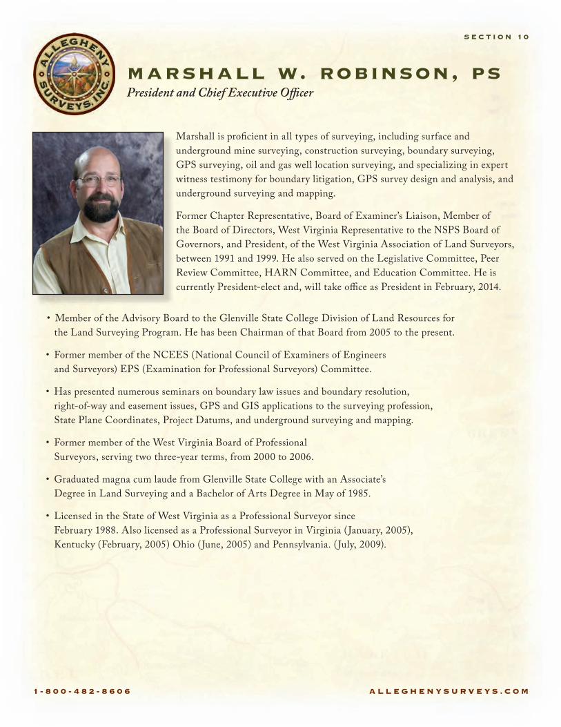
Marshall is pro cient in all types of surveying, including surface and underground mine surveying, construction surveying, boundary surveying, GPS surveying, oil and gas well location surveying, and specializing in expert witness testimony for boundary litigation, GPS survey design and analysis, and underground surveying and mapping.
Former Chapter Representative, Board of Examiner’s Liaison, Member of the Board of Directors, West Virginia Representative to the NSPS Board of Governors, and President, of the West Virginia Association of Land Surveyors, between 1991 and 1999. He also served on the Legislative Committee, Peer Review Committee, HARN Committee, and Education Committee. He is currently President-elect and, will take o�ce as President in February, 2014.
• Member of the Advisory Board to the Glenville State College Division of Land Resources for the Land Surveying Program. He has been Chairman of that Board from 2005 to the present.
• Former member of the NCEES (National Council of Examiners of Engineers and Surveyors) EPS (Examination for Professional Surveyors) Committee.
• Has presented numerous seminars on boundary law issues and boundary resolution, right-of-way and easement issues, GPS and GIS applications to the surveying profession, State Plane Coordinates, Project Datums, and underground surveying and mapping.
• Former member of the West Virginia Board of Professional Surveyors, serving two three-year terms, from 2000 to 2006.
• Graduated magna cum laude from Glenville State College with an Associate’s Degree in Land Surveying and a Bachelor of Arts Degree in May of 1985.
• Licensed in the State of West Virginia as a Professional Surveyor since February 1988. Also licensed as a Professional Surveyor in Virginia (January, 2005), Kentucky (February, 2005) Ohio (June, 2005) and Pennsylvania. (July, 2009).
marshall w. robinson, psPresident and Chief Executive O�cer
S E C T I O N 10
1 - 8 0 0 - 4 8 2 - 8 6 0 6 A L L E G H E N Y S U R V E Y S . C O M
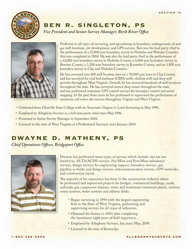
Pro cient in all types of surveying, and specializing in boundary, underground, oil and gas well locations, site development, and GPS surveys. Ben was the lead party chief in the performance of a 27,000 acre boundary survey in Nicholas and Webster Counties that was completed in 2004. He was also the lead party chief in the performance of a 12,000 acre boundary survey in Nicholas County, a 4,000 acre boundary survey in Braxton County, a 3,200 acre boundary survey in Kanawha County, and an 1,850 acre boundary survey in Clay and Nicholas Counties.He has surveyed over 100 well location sites on a 70,000 acre tract in Clay County, and has surveyed for coal bed methane (CBM) wells, shallow well and deep well permits throughout West Virginia. Overall, he has surveyed hundreds of well locations throughout the state. He has surveyed several deep mines throughout the state, and has performed numerous GPS control surveys for boundary control and aerial mapping. In the past three years he has performed or supervised the performance of numerous cell tower site surveys throughout Virginia and West Virginia.
• Graduated from Glenville State College with an Associate’s Degree in Land Surveying in May 1996.• Employed by Allegheny Surveys as a full time party chief since May 1996. • Promoted to Senior Survey Manager in September 2002. • Licensed in the state of West Virginia as a Professional Surveyor since January 2004.
ben r. singleton, psVice President and Senior Survey Manager, Birch River O�ce
S E C T I O N 10
Dwayne has performed many types of surveys which include, but are not limited to, ALTA/ACSM surveys, Pre-Mine and Post-Mine subsidence surveys, design surveys for engineering support, boundary surveys, gas pipeline as-builts and design surveys, telecommunication surveys, GPS networks, and construction layout.�e majority of his experience has been in the construction industry where he performed and supervised projects for bridges, commercial buildings, roads, railroads, gas compressor stations, water and wastewater treatment plants, sanitary sewer systems, water systems and athletic elds.
• Began surveying in 1994 with the largest engineering rm in the State of West Virginia, performing and supervising surveys for all types of industries.
• Obtained his license in 2003 after completing the mandatory eight years of eld experience.
• Employed by Allegheny Surveys, Inc since May, 2008.• Licensed in the state of Kentucky.
dwayne d. matheny, psChief Operations O�cer, Bridgeport O�ce
1 - 8 0 0 - 4 8 2 - 8 6 0 6 A L L E G H E N Y S U R V E Y S . C O M
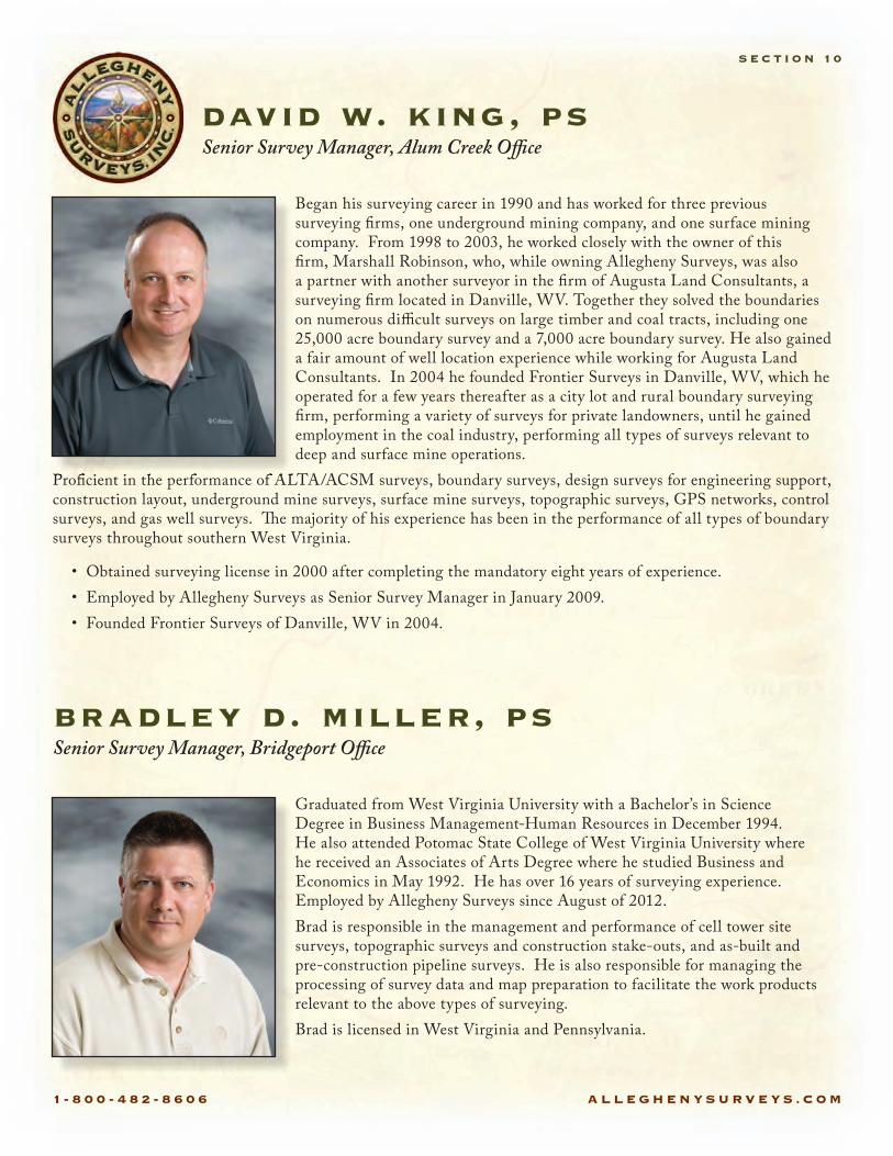
david w. king, ps Senior Survey Manager, Alum Creek O�ce
S E C T I O N 10
Began his surveying career in 1990 and has worked for three previous surveying rms, one underground mining company, and one surface mining company. From 1998 to 2003, he worked closely with the owner of this rm, Marshall Robinson, who, while owning Allegheny Surveys, was also a partner with another surveyor in the rm of Augusta Land Consultants, a surveying rm located in Danville, WV. Together they solved the boundaries on numerous di�cult surveys on large timber and coal tracts, including one 25,000 acre boundary survey and a 7,000 acre boundary survey. He also gained a fair amount of well location experience while working for Augusta Land Consultants. In 2004 he founded Frontier Surveys in Danville, WV, which he operated for a few years thereafter as a city lot and rural boundary surveying rm, performing a variety of surveys for private landowners, until he gained employment in the coal industry, performing all types of surveys relevant to deep and surface mine operations.
Pro cient in the performance of ALTA/ACSM surveys, boundary surveys, design surveys for engineering support, construction layout, underground mine surveys, surface mine surveys, topographic surveys, GPS networks, control surveys, and gas well surveys. �e majority of his experience has been in the performance of all types of boundary surveys throughout southern West Virginia.
Pro cient in the performance of ALTA/ACSM surveys, boundary surveys, design surveys for engineering support,
• Obtained surveying license in 2000 after completing the mandatory eight years of experience.• Employed by Allegheny Surveys as Senior Survey Manager in January 2009.• Founded Frontier Surveys of Danville, WV in 2004.
Graduated from West Virginia University with a Bachelor’s in Science Degree in Business Management-Human Resources in December 1994. He also attended Potomac State College of West Virginia University where he received an Associates of Arts Degree where he studied Business and Economics in May 1992. He has over 16 years of surveying experience. Employed by Allegheny Surveys since August of 2012.Brad is responsible in the management and performance of cell tower site surveys, topographic surveys and construction stake-outs, and as-built and pre-construction pipeline surveys. He is also responsible for managing the processing of survey data and map preparation to facilitate the work products relevant to the above types of surveying.Brad is licensed in West Virginia and Pennsylvania.
bradley d. miller, psSenior Survey Manager, Bridgeport O�ce
1 - 8 0 0 - 4 8 2 - 8 6 0 6 A L L E G H E N Y S U R V E Y S . C O M
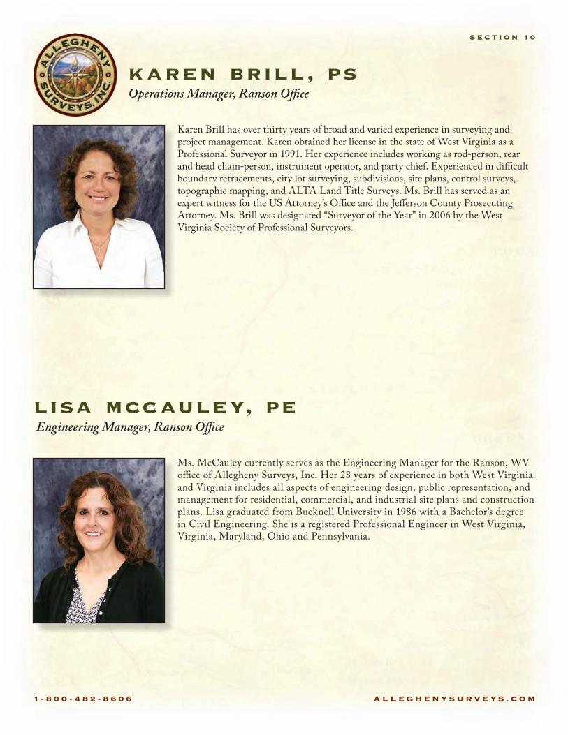
Karen Brill has over thirty years of broad and varied experience in surveying and project management. Karen obtained her license in the state of West Virginia as a Professional Surveyor in 1991. Her experience includes working as rod-person, rear and head chain-person, instrument operator, and party chief. Experienced in di�cult boundary retracements, city lot surveying, subdivisions, site plans, control surveys, topographic mapping, and ALTA Land Title Surveys. Ms. Brill has served as an expert witness for the US Attorney’s O�ce and the Je§erson County Prosecuting Attorney. Ms. Brill was designated “Surveyor of the Year” in 2006 by the West Virginia Society of Professional Surveyors.
karen brill, psOperations Manager, Ranson O�ce
Ms. McCauley currently serves as the Engineering Manager for the Ranson, WV o�ce of Allegheny Surveys, Inc. Her 28 years of experience in both West Virginia and Virginia includes all aspects of engineering design, public representation, and management for residential, commercial, and industrial site plans and construction plans. Lisa graduated from Bucknell University in 1986 with a Bachelor’s degree in Civil Engineering. She is a registered Professional Engineer in West Virginia, Virginia, Maryland, Ohio and Pennsylvania.
lisa mccauley, pe Engineering Manager, Ranson O�ce
S E C T I O N 10
1 - 8 0 0 - 4 8 2 - 8 6 0 6 A L L E G H E N Y S U R V E Y S . C O M
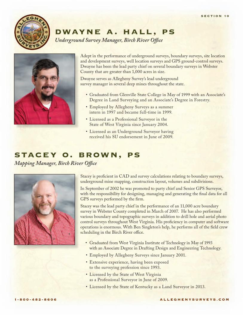
Adept in the performance of underground surveys, boundary surveys, site location and development surveys, well location surveys and GPS ground-control surveys. Dwayne has been the lead party chief on several boundary surveys in Webster County that are greater than 1,000 acres in size. Dwayne serves as Allegheny Survey’s lead underground survey manager in several deep mines throughout the state.
• Graduated from Glenville State College in May of 1999 with an Associate’s Degree in Land Surveying and an Associate’s Degree in Forestry.
• Employed by Allegheny Surveys as a summer intern in 1997 and became full-time in 1999.
• Licensed as a Professional Surveyor in the State of West Virginia since January 2004.
• Licensed as an Underground Surveyor having received his SU endorsement in June of 2009.
dwayne a. hall, psUnderground Survey Manager, Birch River O�ce
S E C T I O N 10
Stacey is pro cient in CAD and survey calculations relating to boundary surveys, underground mine mapping, construction layout, volumes and subdivisions. In September of 2002 he was promoted to party chief and Senior GPS Surveyor, with the responsibility for designing, managing and generating the nal data for all GPS surveys performed by the rm.Stacey was the lead party chief in the performance of an 11,000 acre boundary survey in Webster County completed in March of 2007. He has also performed various boundary and topographic surveys in addition to drill hole and aerial photo control surveys throughout West Virginia. His pro ciency in computer and software operations is enormous. With Ben Singleton’s help, he performs all of the eld crew scheduling in the Birch River o�ce.
• Graduated from West Virginia Institute of Technology in May of 1993 with an Associate Degree in Drafting Design and Engineering Technology.
• Employed by Allegheny Surveys since January 2001.• Extensive experience, having been exposed
to the surveying profession since 1993.• Licensed by the State of West Virginia
as a Professional Surveyor in June of 2009.• Licensed by the State of Kentucky as a Land Surveyor in 2013.
stacey o. brown, psMapping Manager, Birch River O�ce
1 - 8 0 0 - 4 8 2 - 8 6 0 6 A L L E G H E N Y S U R V E Y S . C O M
S E C T I O N 10
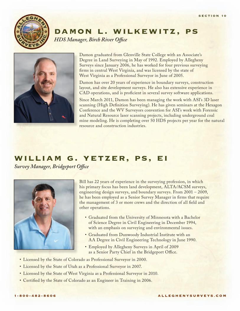
Damon graduated from Glenville State College with an Associate’s Degree in Land Surveying in May of 1992. Employed by Allegheny Surveys since January 2006, he has worked for four previous surveying rms in central West Virginia, and was licensed by the state of West Virginia as a Professional Surveyor in June of 2005.Damon has over 20 years of experience in boundary surveys, construction layout, and site development surveys. He also has extensive experience in CAD operations, and is pro cient in several survey software applications.Since March 2011, Damon has been managing the work with ASI’s 3D laser scanning (High De nition Surveying). He has given seminars at the Hexagon Conference and the WV Surveyors convention for ASI’s work with Forensic and Natural Resource laser scanning projects, including underground coal mine modeling. He is completing over 50 HDS projects per year for the natural resource and construction industries.
• Graduated from the University of Minnesota with a Bachelor of Science Degree in Civil Engineering in December 1994, with an emphasis on surveying and environmental issues.
• Graduated from Dunwoody Industrial Institute with an AA Degree in Civil Engineering Technology in June 1990.
• Employed by Allegheny Surveys in April of 2009 as a Senior Party Chief in the Bridgeport O�ce.
damon l. wilkewitz, psHDS Manager, Birch River O�ce
Bill has 22 years of experience in the surveying profession, in which his primary focus has been land development, ALTA/ACSM surveys, engineering design surveys, and boundary surveys. From 2001 – 2009, he has been employed as a Senior Survey Manager in rms that require the management of 3 or more crews and the direction of all eld and other operations.
• Licensed by the State of Colorado as Professional Surveyor in 2000.• Licensed by the State of Utah as a Professional Surveyor in 2007.• Licensed by the State of West Virginia as a Professional Surveyor in 2010.• Certi ed by the State of Colorado as an Engineer in Training in 2006.
william g. yetzer, ps, eiSurvey Manager, Bridgeport O�ce
1 - 8 0 0 - 4 8 2 - 8 6 0 6 A L L E G H E N Y S U R V E Y S . C O M
S E C T I O N 10
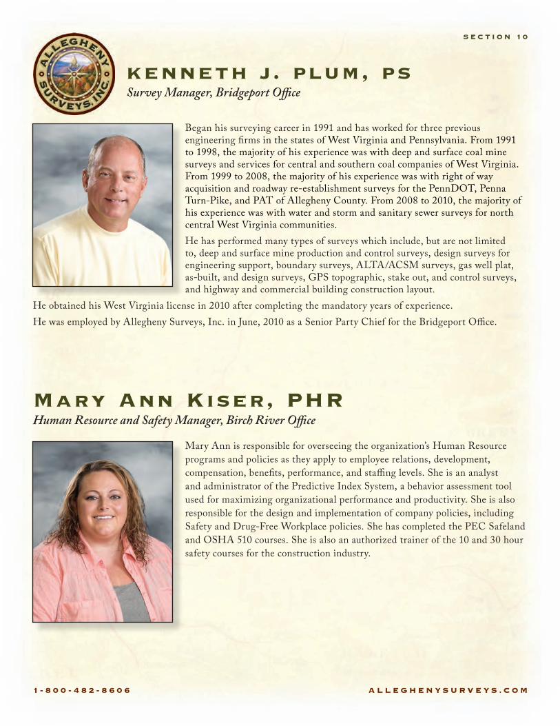
Began his surveying career in 1991 and has worked for three previous engineering rms in the states of West Virginia and Pennsylvania. From 1991 to 1998, the majority of his experience was with deep and surface coal mine surveys and services for central and southern coal companies of West Virginia. From 1999 to 2008, the majority of his experience was with right of way acquisition and roadway re-establishment surveys for the PennDOT, Penna Turn-Pike, and PAT of Allegheny County. From 2008 to 2010, the majority of his experience was with water and storm and sanitary sewer surveys for north central West Virginia communities.He has performed many types of surveys which include, but are not limited to, deep and surface mine production and control surveys, design surveys for engineering support, boundary surveys, ALTA/ACSM surveys, gas well plat, as-built, and design surveys, GPS topographic, stake out, and control surveys, and highway and commercial building construction layout.
He obtained his West Virginia license in 2010 after completing the mandatory years of experience.He was employed by Allegheny Surveys, Inc. in June, 2010 as a Senior Party Chief for the Bridgeport O�ce.
kenneth j. plum, ps Survey Manager, Bridgeport O�ce
Mary Ann is responsible for overseeing the organization’s Human Resource programs and policies as they apply to employee relations, development, compensation, bene ts, performance, and sta�ng levels. She is an analyst and administrator of the Predictive Index System, a behavior assessment tool used for maximizing organizational performance and productivity. She is also responsible for the design and implementation of company policies, including Safety and Drug-Free Workplace policies. She has completed the PEC Safeland and OSHA 510 courses. She is also an authorized trainer of the 10 and 30 hour safety courses for the construction industry.
Mary Ann Kiser, PHRHuman Resource and Safety Manager, Birch River O�ce

1 - 8 0 0 - 4 8 2 - 8 6 0 6 A L L E G H E N Y S U R V E Y S . C O M
jason p. gravleyIT Manager & GIS Analyst, Birch River O�ce
S E C T I O N 10
Graduated from Concord University in Athens, West Virginia with a Bachelor’s of Art Degree in Geography with an emphasis in GIS and Cartography in 2009. Jason was awarded Concord University’s 2009-2010 Outstanding Scholar in Geography and the NCGE/AAG 2010 Excellence Scholarship Award in Geography. He also attended Marshall University where he studied Geography/Meteorology from May 2005 - May 2008. He has over 5 years of GIS experience. Employed by Allegheny Surveys since April of 2011.
Jason is responsible for implementing, monitoring, and maintaining the company’s geodatabase. He is also responsible for providing GIS services to the U.S. Army Corp of Engineers by utilizing data collected by the rm and/or provided by the USARCE. He is pro cient with ESRI software as well as AutoCAD. He performs a variety of tasks for the company that range from geodatabase work and analysis to drawings and other tasks that are relevant to the rm’s activities.
Terri is responsible for the oversight and management of all nancial matters, including nancial reporting, taxation, internal controls and budgeting for Allegheny Surveys.
Prior to joining Allegheny Surveys, Terri worked for nineteen years in various industries gaining experience in auditing, accounts payable, budgeting and forecasting, capital asset management and project analysis. Her experience includes three years for state government where she used her accounting knowledge to train and support the nance o�ces of local boards of education and fteen years in the manufacturing industry where she served in numerous nancial capacities.
She passed the Certi ed Public Accountant exam in 1995 and obtained her CPA license in 1998 after satisfying the minimum experience requirements.
• Graduated with High Honors from Guilford College in Greensboro, NC, earning a Bachelor of Science Degree, with a major in Accounting and a minor in Management in 1992.
• Licensed in the State of West Virginia as a Certi ed Public Accountant since 1998.
• Employed for nearly 15 years in various accounting and nance positions for an OSB manufacturing facility in central West Virginia, the latest position being Financial Analyst.
• Employed by Allegheny Surveys as Financial Manager in January of 2011.
teresa a. hughart, cpa Chief Financial O�cer, Birch River O�ce

1 - 8 0 0 - 4 8 2 - 8 6 0 6 A L L E G H E N Y S U R V E Y S . C O M
Drema brings to Allegheny Surveys a successful history as a community leader in Birch River. She began her employment with Allegheny Surveys in January 2007 as administrative assistant. She is the secretary of the Board of Directors and was recently elected to a second term. She was promoted to the position of Corporate Administrator in 2013. Drema is responsible for the company payroll and oversees various projects for the company.
drema dodrill Corporate Administrator, Birch River O�ce
S E C T I O N 10

1 - 8 0 0 - 4 8 2 - 8 6 0 6 A L L E G H E N Y S U R V E Y S . C O M
Equipment• Trimble S6 2 DR Plus Robotic Total Station• Trimble R8 GNSS Base and
Rover RTK GPS System (six)• Trimble R8 GNSS/VRS Base and
Rover RTK GPS System• Trimble R8 GNSS Base and Trimble R10
GNSS Rover RTK GPS Systems (three)• Trimble S6 (two)• Trimble 4000 SSI Static Dual Frequency
GPS Receiver (four)• Trimble 6000 GeoXH Handheld GNSS
Unit with External Tornado Antenna (three)• Trimble GeoXH mapping grade
GPS Receiver (two)• Trimble ProXT mapping grade GPS Receiver
with Nomad Data Collector (three)• Nikon Nivo 2M Total Stations (six)• Nikon Nivo 5M Total Stations (two)• Leica 403 Total Station (two)• Leica 305 Total Station• Topcon GTS and 223 Total Stations• Topcon GPT 2005 Total Station• Nomad Data Collectors with Survey Pro (�ve)• Leica C10 Scan Station• Leica P20 Scan Station• Metro Tech 850 Pipeline Locator• Metro Tech 810 DX Pipeline Locator
Software• AutoCAD• AutoCAD Map 3D• AutoCAD Cloud Worx• Carlson Survey• Trimble Business Center• Trimble Geomatics O�ce• Trimble GPS Path�nder O�ce• Terra Sync Survey Pro• Trimble Access• Trimble Survey Controller• ESRI ArcGIS 10.2• Microsoft O�ce• Adobe Acrobat Professional• Leica Cyclone 9• 3D Reshaper
equipment & software
S E C T I O N 11