Embed Size (px)
Citation preview

Environmental Infrastructure
Primary School
Playing Pitches
Landscape and BufferingWoodland & Substantial Hedgerow
Green Linkages (pedestrian, cycle & equestrian route)
Bus/Pedestrian/Cyclist/Equestrian/Emergency Vehicle Link
Emergency Vehicle AccessPedestrian/ Cyclist/ Equestrian Link
1. Introduction1. Introduction
About Crest Nicholson
Our aim is to improve the quality of life for individuals and communities, both now and in the future, by providing better homes, work places, retail and leisure spaces and by addressing the needs of the people who will live in and around our developments with supporting facilities and services.
Crest Nicholson is a highly respected developer of sustainable communities.
Our mission is to lead the market in the design and delivery of thriving places in which people want to live and work.
Crest Nicholson’s contribution to the built environment has been recognised with a string of awards, reaching a pinnacle in 2007 with The Queens Award for Enterprise in Sustainable Development. This award is testament to our continued emphasis on producing high quality developments
that champion the very best principles in sustainability and design. It marks a tangible milestone in our mission to deliver communities where people genuinely want to live, work and play - places with a real heart and soul.
Joint Area Action Plan (JAAP) Horsham District Council and Crawley Borough Council have been through a lengthy and thorough search for a site for a new neighbourhood West of Crawley. Crest Nicholson’s site West of Bewbush was selected as the most suitable location and will provide around 2,500 homes including affordable housing to meet local needs over approximately 132 hectares.
Following this, the West of Bewbush Joint Area Action Plan (JAAP) was produced to inform and guide development of the site. This was adopted in July 2009 by both Horsham District Council and Crawley Borough Council.
Development will be guided by the principles set out in the JAAP and will provide:
2,500 dwellings of a variety of sizes to • meet housing need with a target of 40% being provided as affordable housing
A neighbourhood centre providing retail, • healthcare services, a community centre and library
A network of formal and informal open • space linking the site with the provision of cycle ways, footpaths and a high quality bus service linking the neighbourhood to the town centre
Education facilities including a new • primary school
Employment space for small, start up and • micro businesses
Land allocated for a new railway station • pending a defi nitive decision by Network Rail to provide such a service
The new neighbourhood will be delivered over a number of core phases with key services, facilities and infrastructure provided to support development.
...the Vision... to create a sustainable new neighbourhood, a neighbourhood in which residents can become involved in their community and share the benefits of a high quality of life...
Emerging Concept Plan
Joint Area Action Plan
Policy WB1Road Infrastructure
Neighbourhood Centres (res, comm & emp uses)Highway Infrastructure Safeguarding
Railway Station
Railway Station Parking
ResidentialInformal Open Space
Public Rights of Way
AONB
Strategic GapAncient WoodlandSSSI
SNCIHorsham/ Crawley BoundaryCrawley BUAB
Crawley Strategic Housing DevelopmentCrawley Neighbourhood Centre Renewal
Scheduled Ancient Monument
Land at Risk of Flooding - Sept 2007
Site Boundary
Residential (includes non strategic open space)
Mixed Use (including serviced employment land)
Environmental Infrastructure Area
Signifi cant Existing Vegetation Retained
Retained Vegetation to include Leisure Uses
Local and Neighbourhood Parks
Open Space including Linear Open Spaces
3FE Primary School
Primary School Land which would revert to residential if a 2FE Primary School is required
Car Park Locations
Approximate Alignment of Public Transport Corridors
Main Site Access
Bus Only Sections
Strategic and Leisure Routes
Existing Bridleway Routes
Possible Station
Possible Alignment for Watercourse
Possible Bridge Locations
Landscape and Buffering

2. The Site Today2. The Site Today
Viewpoint 1: The Knoll Panorama
Viewpoint 2 & 3: The Brook and Access Road Panorama
...mature trees and woodland represent significant features
within the landscape...
Constraints and Opportunities Plan
Viewpoint 1
Viewpoint 2
Viewpoint 3
(1a)
(1b)
(1c)
(1d)
(2a)
(2b)
(3)
Site Boundary
Railway
Public Right of Way
Possible Site Access
Possible Pedestrian/ Cyclist/ Equestrian Link
Possible Bus/ Pedestrian/ Cyclist/ Equestrian LinkPossible Emergency Vehicle Access
Possible Railway Crossing Points
Water Bodies
Built Up Area
Open Space
Landfi ll Area
Existing Planting
Hedgerows
Root Protection Zones
AONB
Daytime Noise Level Above 63dB
Flood Plain 2 - Medium Probability of Flooding
SNCI
Ancient Woodland
SSSI
Scheduled Monuments
Noise Issue
Indicative Culverts
Railway Signals
Boundary to License No: WSX/L1/0174
Existing BT Line
Existing Water Main
Access
Land Uses
Environmental
Services

3. Landform and Greenspace3. Landform and Greenspace
LandformThe major benefi t of the West of Bewbush site is that the inert fi ll • can be re-shaped to create the landform which is most suitable for the development.
The proposed landform introduces diversity in gradient and • aspect to create visual interest and variety in character. Gradients vary between 1:4 and 1:60 for the school and shops.
The landform minimises the amount of earth moving by retaining • as many existing slopes as possible, and thus reduces the potential for environmental impacts on surrounding areas. In particular, the proposed landform allows the retention of virgin land to the west of Bewbush.
The landform has been carefully designed so as to produce • an almost perfect cut and fi ll balance. We estimate that there could be up to 50,000 cu m of methanogenic material on site. This would be removed off-site and all other materials would be retained on site.
Bewbush Brook would be partially realigned in order to provide a • broader, more gently sloping development platform south of the railway line.
Public Open SpaceThe public realm has been designed to exploit the existing • landform, views and surrounding landscape character retaining much of the existing woodlands and mature hedgerows.
The landscape infrastructure has been designed to provide areas • of varying character, scale, and setting. The landscape will provide a network of formal and informal green spaces suitable for a wide range of uses including opportunities for a village green, town park, community gardens, allotments, play areas, sports pitches and multi use games courts.
The landscape setting has been carefully designed to provide • a network of safe pedestrian, cycle and bridleways throughout the site which are free from vehicular traffi c to offer both clear and direct routes to community facilities and a range of circular recreational routes.
LEVEL ABOVE ORDNANCE DATUM (metres)
...the landform has been carefully designed so as to produce an almost perfect cut and fill balance...
Existing Landform
Proposed Landform
Public Open Space Concept Diagram
Illustrative Perspective of Realigned Brook
Primary Streetscape
Leisure Routes
Railway
SUDs; Primary Swales and Attenuation Ponds
Recreational Greenways (to provide: safe routes; vistas to north and south ridgeways; trim trail activities; play areas; resting areas; social areas; habitat areas)
Primary Civic Spaces
Primary Green Spaces (to provide playing fi elds; pocket parks and gardens; tranquil spaces; social spaces; festival and event spaces; allotments)
Vertical Features

Integrating Sustainable Development Principles
The proposals at West of Bewbush are seeking to implement best practice approaches to create a community achieving exemplary levels of sustainability. The development is being designed with the over-arching aim of enabling sustainable lifestyles for its residents.
Options for West of Bewbush are being investigated and opportunities explored in relation to the following themes:
Sustainable Lifestyles Many aspects of the new community proposals for West of Bewbush will enable residents to live a more sustainable lifestyle, including options such as:
Green routes and open spaces with cycle • paths and pedestrian/cycle priority routes, encouraging walking and cycling as an alternative to travelling by car
A train station and site-wide bus routes • promoting use of public transport, and minimising transport carbon emissions
Energy effi cient homes and low-carbon • infrastructure enabling reduction in resident’s carbon footprint
Energy Effi ciencyEffi cient building design will be incorporated into homes throughout the West of Bewbush development. Homes will be signifi cantly more energy effi cient than typical existing homes, helping to keep energy bills low.
Renewable and Low Carbon Energy GenerationA range of low-carbon energy options and renewable energy sources are being considered to provide on-site ‘green’ energy, leading to reduced carbon emissions including:
Biomass fuel technologies.•
Building integrated renewable energy • systems, such as solar power and solar heat generation.
Water ManagementReducing water consumption and managing it effectively is being considered as part of enabling sustainable living.
Waste ManagementThe West of Bewbush development proposals will incorporate best practice approaches to waste management.
Neighbourhood CentreA Neighbourhood Centre will form the heart of the new community at West of Bewbush. It will refl ect the Crawley neighbourhood principle and act as the focus for services, facilities, community activity and integration. Key facilities are prescribed in the JAAP and the composition of the Centre could include the following uses:
2/3 Form of Entry Primary School •
Nursery •
Serviced Employment Land •
Retail •
Residential •
Sheltered Housing •
Library •
Health Centre •
Community Centre •
Public House•
4. Sustainability and Facilities4. Sustainability and Facilities
...to create a community achieving exemplary levels of sustainability...
...a range of low-carbon energy options and renewable energy sources are being considered to provide on-site ‘green’ energy...
Illustrative Perspective of Neighbourhood Centre
5. Access and Movement5. Access and Movement
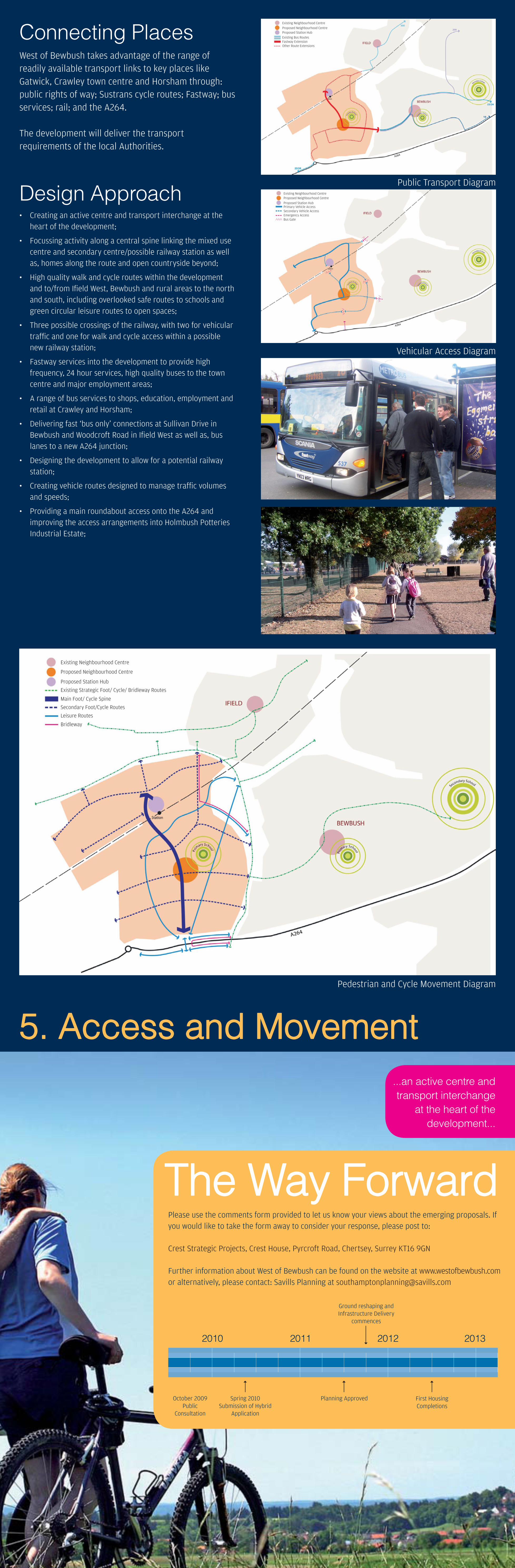
Connecting PlacesWest of Bewbush takes advantage of the range of readily available transport links to key places like Gatwick, Crawley town centre and Horsham through: public rights of way; Sustrans cycle routes; Fastway; bus services; rail; and the A264.
The development will deliver the transport requirements of the local Authorities.
Design ApproachCreating an active centre and transport interchange at the • heart of the development;
Focussing activity along a central spine linking the mixed use • centre and secondary centre/possible railway station as well as, homes along the route and open countryside beyond;
High quality walk and cycle routes within the development • and to/from Ifi eld West, Bewbush and rural areas to the north and south, including overlooked safe routes to schools and green circular leisure routes to open spaces;
Three possible crossings of the railway, with two for vehicular • traffi c and one for walk and cycle access within a possible new railway station;
Fastway services into the development to provide high • frequency, 24 hour services, high quality buses to the town centre and major employment areas;
A range of bus services to shops, education, employment and • retail at Crawley and Horsham;
Delivering fast ‘bus only’ connections at Sullivan Drive in • Bewbush and Woodcroft Road in Ifi eld West as well as, bus lanes to a new A264 junction;
Designing the development to allow for a potential railway • station;
Creating vehicle routes designed to manage traffi c volumes • and speeds;
Providing a main roundabout access onto the A264 and • improving the access arrangements into Holmbush Potteries Industrial Estate;
Please use the comments form provided to let us know your views about the emerging proposals. If you would like to take the form away to consider your response, please post to:
Crest Strategic Projects, Crest House, Pyrcroft Road, Chertsey, Surrey KT16 9GN
Further information about West of Bewbush can be found on the website at www.westofbewbush.com or alternatively, please contact: Savills Planning at [email protected]
2010 2011 2012 2013
Spring 2010Submission of Hybrid
Application
October 2009 Public
Consultation
Planning Approved First Housing Completions
Ground reshaping and Infrastructure Delivery
commences
The Way ForwardThe Way Forward
...an active centre and transport interchange
at the heart of the development...
Pedestrian and Cycle Movement Diagram
Public Transport Diagram
Vehicular Access Diagram
Existing Neighbourhood CentreProposed Neighbourhood CentreProposed Station HubExisting Bus RoutesFastway ExtensionOther Route Extensions
Existing Neighbourhood CentreProposed Neighbourhood CentreProposed Station HubPrimary Vehicle AccessSecondary Vehicle AccessEmergency AccessBus Gate
Existing Neighbourhood Centre
Proposed Neighbourhood Centre
Proposed Station Hub
Existing Strategic Foot/ Cycle/ Bridleway Routes
Main Foot/ Cycle Spine
Secondary Foot/Cycle Routes
Leisure Routes
Bridleway