Embed Size (px)
Citation preview

ASSESSMENT OF OFFSHORE SAND RESOURCES FOR BEACH NOURISHMENT ALONG THE SOUTHWEST COAST OF FLORIDA
Charles W. Finkl;† Jeffrey L. Andrews,†, and Lindino Benedet, L.†,‡
†Coastal Geology & Geomatics, Coastal Planning & Engineering, Inc., 2481 NW Boca Raton Boulevard, Boca Raton, Florida; [email protected]; 561-391-8102
‡Delft University of Technology, 2600 GA Delft, The Netherlands
Regional sand resource investigations along the west coast of Florida (from Pinellas County
to Collier County) identify types of primary depositional settings that are commonly explored for beach nourishment projects and indicate future availability of sand for beach restoration. Because the nature of sedimentary deposits determines sand quality and its potential use for beach nourishment, it is necessary to understand the occurrence and evolution of depositional environments on the continental shelf. The distribution of beach-quality sands on the seabed is not random, but spatially well defined in terms of stratigraphy, grain size and composition, age of materials, and erosional-depositional events. Offshore sand resources along the West Florida Shelf (WFS) fall into three broad categories: (1) sand ridges; (2) ebb-tidal shoals, and (3) shoreface sands. Sand ridges generally occur in water depths from 4 to 30 m and are associated with modern shelf processes and relict geological and geomorphological controls (e.g. bedrock slope). Ebb-tidal shoals have been exploited for decades as sand sources (borrows) for beach nourishment projects in the region. Shoreface sands, which occur at relatively shallow depths (i.e. 2 to 6 m), are generally thin and discontinuous along this coast.
Proper assessment of sand resources requires definition of reserves and resources within the
purview of uncertainty analysis in the USMinval Code. Quantification of uncertainty in marine substrate mapping should become a crucial step in the classification of resources and reserves in the development of potential borrow areas. This procedure is necessary because of natural variability in sedimentary deposits and increasing specificity of requirements for beach fill.
INTRODUCTION A range of sedimentary deposits occurs on the inner continental shelf along the
southwest coast of Florida. Description of the geologic setting is central to comprehension of sedimentary distribution patterns, particularly as they relate to the presence of bedrock seafloor surfaces and the nature of sediments sitting on them. The nature of sedimentary deposits determines sand quality and its potential use for beach nourishment. It is thus helpful to understand generalized depositional settings of shelf environments because the distribution of beach-quality sands on the seabed is not random, but spatially well defined in terms of stratigraphy, grain size and composition, age of materials, and erosional-depositional events. Shelf sediments off southwest Florida are part of a larger continuum that lies at the center of an ancient carbonate platform that faces an enormous ramp. This ancient carbonate platform forms the proximal portion of the west Florida shelf-slope system and exerts large-scale control on coastal geomorphology, the availability of sediments, and wave energy (Hine et al., 2001, 2003). Although this region is relatively sediment-starved, ebb-tidal deltas and offshore sand ridges provide a ready-made source of sand for beach nourishment (Hine et al., 1986, 2003). Salient characteristics of this geologic environment, particularly the occurrence of
sand ridge fields, are briefly summarized here as they relate to marine aggregates as resources for beach nourishment.
Crucial to discussion of sedimentary environments is application of appropriate
terminology that identifies analyses, measurements, and reasonableness of geologic inferences as they pertain to marine aggregates. Although not commonly applied to offshore sand searches, the extent to which deposit attributes are known should be identified as part of the process that discriminates sedimentary bodies into borrows. Standard terminology already developed by the mineral industry is relevant in this regard viz. reserves, resources, and assurance of assessment. These concepts are related to offshore sand searches for aggregate mining on the inner continental shelf.
MINERAL RESERVES, RESOURCES AND
CERTAINTY OF ASSESSMENT Definitions of mineral reserves, resources, and certainty of assessment, as adopted
by the U.S. Bureau of Mines and U.S. Geological Survey in 1980 (SME, 2005), foster a basis for uniform terminological identification and more accurate communication (e.g. Abbott and Guamera, 2003). McKelvey’s (1972) terminology, as modified by Brobst and Pratt (1973), applies to the mineral endowment (quantity and quality of a material) of an area. Resource assessment studies evaluate the likelihood of the occurrence of mineral deposits (resources) in terms of levels of mineral resource potential and the certainty of assessment (Goudarzi, 1984). Likelihood of occurrence is not a measure of the resources themselves but a probabilistic statement within a specified range of error.
The total mineral endowment of an area is divided into two major parts: identified
resources and undiscovered resources. These are in turn subdivided on the basis of the adequacy of knowledge about the deposits. A resource is a concentration of naturally occurring material in or on the Earth’s crust in such form that economic extraction is now feasible or at some time in the future. The existence of undiscovered resources is surmised from broad (regional) knowledge and theory. A reserve is that portion of an identified resource that can be economically and legally extracted at the time of determination. According to the USMinval Code, measured or proven reserves are geologically well known sites for which quantity and quality are known within a 20% margin of error (Abbott and Guamera, 2003).
The level of certainty applied to a rating of resource potential indicates the degree
of confidence with which the rating was assigned. The level of certainty in the USMinval Code reflects: (1) the adequacy of geologic data available at the time of determination and (2) how well the specific deposit is understood. The following levels of certainty are thus recognized. Level A – available information is not adequate to determine the level of resource potential. Level B – the geologic environment is known but key evidence is lacking on rock units, structure, activity of resource-forming processes, etc. Level C – geologic environments are clearly defined but specific evidence is inadequate to evaluate past activity of resource-forming processes. Level D – geologic environments are clearly defined, activity of resource-forming processes can be ascertained, and data on deposit types are well understood. As part of the aggregate mining process in the marine
environment, offshore sand searches operate at uncertainty Level A for preliminary or reconnaissance surveys. Detailed sand searches initially operate at Level B uncertainty but culminate with uncertainty in Level C when a borrow area is “proven out.” Uncertainties may be narrowed at Level D, but this is rarely achieved in normal sand searches.
SAND RESOURCES ON THE INNER CONTINENTAL SHELF
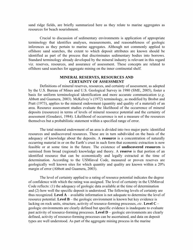
Sand resources along the southwest coast of Florida (southeastern part of the West Florida Shelf, WFS) (Figure 1) fall within three broad categories: (1) sand ridges; (2) ebb-tidal shoals, and (3) shoreface sands. These categories may be further subdivided based on origin (provenance), chemical composition, granulometry, and hydrodynamics. Sand ridges generally occur in water depths from 4 to 30 m and are associated with modern shelf processes and relict geological and geomorphological controls (e.g. bedrock slope). The ridges off the southwest coast may be associated with cuspate forelands and sedimentary headlands, or with reworked paleo ebb-tidal shoals and barriers. The ridges are obliquely oriented to the coast although shore-parallel and shore-transverse ridges occur in restricted locations.
Figure 1. Location diagram showing color-ramped bathymetry along the west coast of Florida. The shallow-water NOAA-derived imagery extends about 25 km offshore on the West Florida Shelf (WFS). Sand resources occurring off the southwest coast of the Florida Peninsula are morphologically differentiated by the bathymetry in terms of ebb-tidal shoals, sand ridges, and shoreface attached deposits.

Ebb-tidal shoals are large reservoirs of sand along the southwest coast. For decades, ebb-tidal shoals and associated sandy deposits have been exploited for beach nourishment projects in the region. These shoals exhibit a range of shapes and forms that are morphodynamic responses to balances between wave and tidal forcing. Shoreface sands, which occur at relatively shallow depths (i.e. 2 to 6 m), are generally thin and discontinuous along the coast. They have been exploited for beach nourishment projects.
Additional deposits that have been previously investigated as potentially beach-
compatible sediments include infilled karst depressions on Miocene and Pleistocene bedrock surfaces (hardgrounds) (e.g. Finkl et al., 2003a,b). Some of these infilled solution holes were investigated offshore Collier County (e.g. Coastal Engineering Consultants-Alpine, 2000) but vibracore samples contained fine-grained sediments with rubble fragments (silts and clays and rock) that are unsuitable for beach nourishment. Sand Ridges
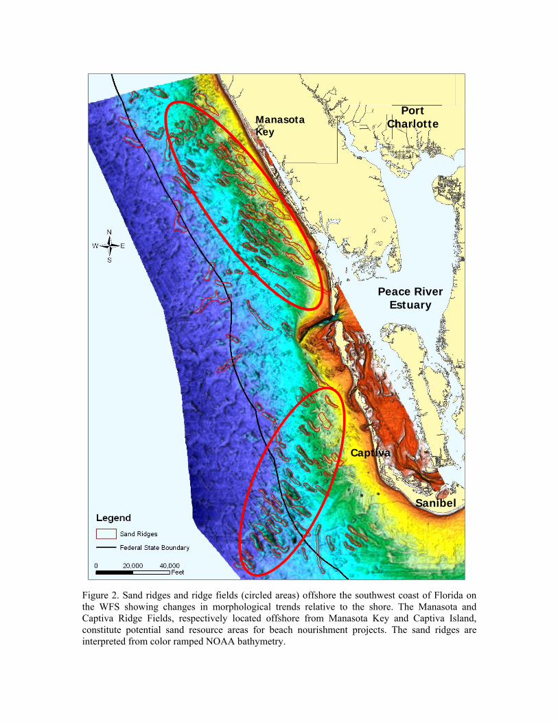
The presence of sand ridges on the shelf has been appreciated as singularities for some time, but new studies emphasize the widespread occurrence of sand ridge fields that greatly enhances the potential for locating multiple good-quality borrow sites on ridges (e.g. Gelfenbaum et al., 1995; Dyer and Huntley, 1999; Locker, 2003; Benedet et al., 2004; van der Meer et al., 2005; Jones et al., 2005). Multiple sand ridge fields occupy different parts of the WFS and although the sand ridges display similarities, there are notable differences in orientation, morphology, and composition (Figure 2). Due to limited thickness (1 to 2 m) of some ridges first explored, it was initially thought that sand ridges offshore the southwest coast could not provide sufficient volumes to support projected beach nourishment requirements. Today, however, exploitation of thinner ridges is feasible using hopper dredges that are designed to dredge long shallow cuts.
The shoreline-oblique (30-50º) inner shelf sand ridges offshore Sand Key, for
example, unconformably overlie Miocene limestones of the Arcadia Formation that in turn is also partly overlain by a thin veneer of mixed carbonate and siliciclastic sands and gravels (Edwards et al., 2003; Locker et al., 2003). These sand ridges have been investigated previously as sources of sand for beach nourishment (Gelfenbaum et al., 1995). Ridge orientation, spacing and alignment, which seem to be less well-defined offshore from major ebb-shoal systems (e.g. ridges near the Egmont ebb-tidal shoal), tend to be shore parallel to slightly shore oblique in wave dominated areas and offshore from sedimentary headlands. Shore transverse ridges occur exclusively offshore Anna Maria Island and Longboat Island. Generally, the troughs between successive sand ridges are hardgrounds comprised by Miocene to Pliocene limestones or very thin (less than 1 m) layers of coarse shell fragments mixed with siliciclastic sands. Ridge relief tends to be subdued in shallow waters, attributed to waves that tend to flatten the ridges according to Jones et al. (2005). Ridge orientation seems to be controlled by interactions between wave and tide-induced currents when ridge fields occur offshore from major tidal inlets and changes in shoreline orientations at sedimentary headlands.
Grain-size and compositional variations along this portion of the WFS show a cross-
shelf gradation between beach and nearshore siliciclastic sand and the carbonate shelf
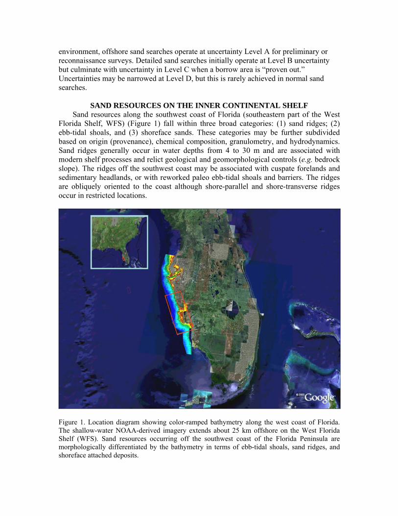
sediment. In general terms, carbonate percentage increase with distance offshore but the facies transition is irregular in shape and closely linked to the morphology of the inner shelf (Gelfenbaum et al., 1995; Brooks et al., 2003; Locker et al., 2003). Most of the unconsolidated sediments on the inner shelf are concentrated in low-relief ridges with older strata exposed in intervening troughs (Locker et al., 2003). The sand ridges unconformably overlie the underlying Miocene and Pliocene bedrock (hardbottoms). The series of low-relief ridges along this coast are smaller in length and width to ridges found on continental shelves of the eastern United States (e.g. Duane et al., 1972), eastern Canada (e.g. Hoogendorn and Dalrymple, 1986), and Europe (e.g. Dyer and Huntley, 1999).
Sand Ridge Stratigraphy and Age Stratigraphically, the sand ridges are separated from the underlying Tertiary
carbonate strata by a Holocene ravinement surface (Twichell et al., 2003). The top of the oldest unit, the present hard rock seafloor, is Miocene to early Pliocene Hawthorn Group (Arcadia, Peace River and Tamiani formations). Depressions in these bedrock (hardbottom) units, which are related to karst topography, contain some Pleistocene strata immediately below the ravinement surface cut during the Holocene marine transgression. The youngest units are ridge sediments which are generally late Holocene in age (Twichell et al., 2003). The ravinement surface separating ridge sands from older deposits is flat lying with a thin discontinuous veneer of sediments in troughs between ridges. The flatness of the surface suggests that there has been minimal erosion of trough floors during the Holocene rise in sea level.
The sand ridges are generally shoreface-detached (except for transverse ridges
offshore Anna Maria Island) and sediment starved. They are mostly part of an active seafloor environment, although there may be truncated remnants that are now buired. Evidences suggesting that these are active sand bodies includes: (1) relatively young AMS 14C dates (< 1600 YBP) from foraminifera in the shallow subsurface (1.6 m below seafloor), (2) sediment textural boundaries and development of small bedforms in an area of constant and extensive bioturbation, (3) morphological asymmetry of sand ridges, and (4) exceedance of critical threshold velocity of sediment transport (based on current meter data) (Harrison et al., 2003) by storm-induced bottom flow. Compositionally, the sand ridges contain a mixed siliciclastic - carbonate sand facies that dominates the surface and shallow subsurface (to -1.6 m) (Edwards et al., 2003). The carbonate content ranges from 7.1% to 51.8%, with the remainder being quartz. Mean grain size ranges from 0.09 mm to 0.8 mm. Composition of sand ridge sediments is variable and the decision to exploit one ridge over another generally determines the composition of renourished beaches.
Finkl et al. (2003b) and Benedet et al. (2004) verified a distinct differentiation in
composition and stratigraphic sequence between the ridges offshore Sanibel Island and ridges offshore Naples Beach in Collier County. Vibracore samples from the ridges offshore Sanibel Island indicated that they contain sediments that are very similar to those occurring in the present beach-surf zones viz. siliciclastic sands with 10 to 30% carbonate content, 0.25 to 0.35 mm grain size with extremely low silt contents and a few

scattered shell fragments. The Captiva-Sanibel ridges also exhibit greater relief (e.g. 3 to 9 m) and lateral extent (3 to 6 km) (Figure 2).
On the other hand, the ridges located offshore from the City of Naples have lower relief (1-3 m) and limited lateral extent (generally less than 3 km) with generally fining upward sequences that include thin intercalations of mixed fines (clay-silt) plus whole shells. Basal sequences on the Naples ridges consist of shells and rock fragments mixed with silty sands, whereas upper layers consist of mostly finer-grained siliciclastic-carbonate sand mixtures. These different origins and compositions infer different evolutionary mechanisms of these ridge systems, as discussed by Benedet et al. (2004) and Finkl et al. (2003a,b; 2005).
Evolution of Ridges and Reworking by Modern Shelf Processes The shoreline-oblique (30º-50º), inner shelf sand ridges offshore southwest Florida
occur in an environment that is underlain by limestone and covered by a thin veneer of mixed carbonate and siliciclastic sands and gravels (Edwards et al., 2003; Locker et al., 2003). The ridges tend to be thicker and more widely spaced with increasing water depth. This is similar to observations along the New Jersey coast (e.g. Stubblefield et al., 1984).
Theories accounting for the modern formation of seabed sand ridges consider
interacting systems of waves, currents and sediments and differential feedback mechanisms between them (termed morphodynamics). Numerous theories have been posited to explain ridge formation offshore from sedimentary headlands (e.g. Duane et al., 1972) and shoreline re-orientations such as Sand Key and Sanibel Island (cf. Figure 2). Huntley and Dyer (1999) classified these types of features as “headland banks” or “en echelon banks” that formed along the retreat paths of headlands and spit growth. These researchers describe this type of bank formation in terms of spit growth and subsequent spit detachment from the headland as the coastline retreats. The effects of currents and wave gradients can subsequently reshape and fragment these features to form multiple ridge systems.
On the European shelf of the North Sea, sand banks that occur offshore from
headlands have been linked to residual gyres, a process that invokes Coriolis forces to explain preferential accretion on one side of a headland (Pingree and Maddock, 1979). Jones et al. (2005), using 3D hydrodynamic models, verified that the location of sand banks did not necessarily coincide with the location of residual gyres. They instead linked the location of sand banks offshore of coastal headlands with flow patterns. That is, when flow speed is directed offshore with greater velocity near the headland area, these currents disperse and decrease in velocity just offshore of the headland where the banks are formed. Although these are attractive process-based hypotheses, more research is needed to ascertain whether the shoreline retreat model or the current vorticity model, or combinations of both, are responsible for the generation and maintenance of the sand ridges offshore sedimentary headlands (e.g. Sand Key and Sanibel Island) along the WFS. These hypotheses need to be verified in the field and in numerical modeling studies to ascertain their applicability to the WFS.
Peace River Estuary
Port Charlotte Manasota
Key
Sanibel
Captiva
Figure 2. Sand ridges and ridge fields (circled areas) offshore the southwest coast of Florida on the WFS showing changes in morphological trends relative to the shore. The Manasota and Captiva Ridge Fields, respectively located offshore from Manasota Key and Captiva Island, constitute potential sand resource areas for beach nourishment projects. The sand ridges are interpreted from color ramped NOAA bathymetry.
Independent from evolutionary mechanisms, once a bed disturbance (sand ridge) is formed, the stability theories of Huthnance (1982) may help explain growth and maintenance even if the forces that originally generated the banks are no longer operative. Huthnance (1982) explained the growth and realignment of ridges by combining effects of cross-bank and along-bank flows (current refraction and bed friction). According to his theory, the along-crest component of currents will be reduced by the influence of friction-refraction turning the current vectors toward the ridge crest. In a cross-bank scheme, the flow speed is reduced on the downstream side of the bank due to friction over the ridge, thus inducing sediment to fall on the ridge area. For the WFS ridges, recent current meter data indicates that the critical threshold velocity of sediment transport is frequently exceeded (Harrison et al., 2003), so that these sand ridges and bedforms are influenced by modern storm-induced bottom flows. The same authors (Harrison et al., 2003) also invoked the stability principles of Huthnance to explain sand ridge growth.
Other sedimentary ridges, occurring offshore straight shorelines may have different
genesis and control mechanisms as indicated by their different geomorphology and stratigraphy. The ridges offshore Collier County, for example, exhibit stratigraphic sequences that resemble paleo inlet ebb-tidal shoal environments. This is, their genesis may be linked to the inlet retreat path model described by McBride and Moslow (1991). Because ebb-shoals along this coast are relatively small and sediment supply is meager, the ridges are thinner and have less lateral extent than those described by McBride and Moslow (1991). They do, however, contain a sedimentary package that describes a succession of bay-shoal sediments rich in shells and silt overlain by relatively clean, re-worked beach-marine sands on the top sequences.
Ebb Tidal Shoals
There are thirty-four inlets along the west coast of Florida (e.g. Dean and O’Brien, 1987; Finkl, 1994). Sand volumes stored in west coast inlets constitute an important source of clean sand for beach nourishment. Because ebb-tidal shoals accumulate sediments that are transported by alongshore currents in the surf zone, they are generally composed of beach-compatible sediments. Due to high energy conditions of their natural environment, which is subject to the constant action of currents and tides, ebb-tidal shoals generally contain sands that are useful (devoid of fines and organic materials) for beach nourishment.
Most of these inlets have been modified by engineering works including
maintenance dredging to promote navigation conditions, sand extraction for beach restoration, and stabilization by coastal structures, inlet opening and closure, etc. Even though tide range is relatively small (less than 100 cm), low wave energy and large back bay (lagoonal) areas contribute to the opening and maintenance of tidal inlets. Additionally, low wave energy facilitates build up and maintenance of large ebb-tidal shoals that store large volumes of sand (Hine et al., 1986).
Many of the large ebb-tidal shoals in the area (e.g. those offshore Tampa Bay) mouth
and the entrance of Charlotte Harbor) are tide-dominated and store large volumes of sand

that is not significantly influenced by waves. Due to the nature of these large tide-dominated sand bodies, they are poor sediment bypassers and constitute permanent sinks of littoral drift sediments. On the other hand, shoals offshore small tidal inlets with smaller tidal prisms are predominantly wave-influenced and are better sediment bypassers (e.g. Johns Pass, Midnight Pass, and Blind Pass - the two last are currently closed). These inlets have well-developed flood-tidal shoals and relatively unstable cross-sectional areas when compared to their counterparts (large tide-dominated inlets).
Approximate sand volumes stored in ebb shoals of these 34 tidal inlets were
quantified by Hine et al. (1986) and Dean and O'Brien (1987), who also estimated the impacts of inlets on coastal sediment budgets. This work was updated with site-specific inlet management plans and consulting reports by Balsillie and Clark (2001). Their methodologies to estimate ebb-tidal shoal volumes included interpretation of aerial photographs, inspection of historical maps, analysis of documents, field investigations (bathymetric data), and literature reviews. Nearshore Sand Bodies
Nearshore sand bodies include blanket sand deposits that extend from the surf zone to offshore exposure of bedrock (hardground) or the beginning of sand ridge fields. They are of limited extent on the WFS because this coast is sediment starved and there are extensive nearshore hardgrounds (bedrock exposures). Although rare, there are some sand deposits that blanket shallow (3 to 10 m) waters that may be explored for coastal restoration. Nearshore sedimentary covers are, however, more common offshore from barrier islands that lie adjacent to major tide-dominated inlet systems. Shelf cross-sections by Locker et al. (2003) show, for example, that nearshore sand blankets 1 to 4 m thick occur offshore Anclote Key, Mullet Key, Treasure Island, and Anna Maria Island (interpreted as remnants of the Tampa Bay ebb-tidal delta). Based on their interpretations, it is reasonable to assume that these kinds of nearshore sand bodies may also occur offshore from Gasparilla Island and Cayo Costa (remnants of the Boca Grande - Charlotte Harbor ebb-tidal shoal).
SAND RIDGES AS POTENTIAL RESOURCES FOR BEACH NOURISHMENT
Seafloor image patterns were obtained from NOAA bathymetric data that were compiled from 1970-1980s soundings and re-gridded at 100 m resolution to produce digital color-ramped charts. The bathymetric image constructed for the inner WFS (Figure 2) covers about 3686 km2. Of this total area, sand ridges account for about 204 km2 or about 5.5%. Although percent coverage of the seafloor by ridges is small and patchy, the collective volumes are large (187 x 106 m3) assuming an average 1 m thickness. The larger sand ridges individually cover 4 to 8 km2 while many of the smaller ridges average less than one square kilometer in area. Perusal of Figure 2 shows that the sand ridges tend to occur in distinct clusters with the same general NW-SE geographic orientation, which are referred to here for simplicity as the Manasota Ridge Field and the Captiva Ridge Field. The ridges often occur in an en echelon pattern with lateral spacing ranging from 1,000 to 2,000 m. Both ridge fields constitute offshore sand resources where the Manasota ridges collectively make up 91 x 106 m3 for 1-m thickness (182 x 106

m3 for 2-m thickness) over 192-km2 ridge area and where the Captiva ridges comprise 68 x 106 m3 for 1-m thickness (136 x 106 m3 for 2-m thickness) over 75-km2 ridge area.
The rating of resource potential for the two ridge fields is Level B. Both fields require further investigation to better define the geologic environment and acquire key evidence on lithologic units, sedimentary architecture, and activity (timing and evolutionary sequence) of the resource-forming processes. With detailed investigation of individual ridges as possible borrow sites, the level of certainty applied to the resource potential increases to Level C. At this point, a ridge or portion thereof can be identified as a reserve, as per the USMinval Code (Abbott and Guamera, 2003), for aggregate mining. Proven reserve volumes are much less than sand resource volumes, but the proportions (resource vs. reserve volumes) will change over time as renourishment needs dictate standards for what is acceptable to place on the beach.
DISCUSSION
Updated bathymetric surveys of the WFS are needed to better asses the sand resource potential for beach nourishment. Inasmuch as the regional bathymetric data used in this study is two to three decades old, modern digital bathymetric data will no doubt show somewhat different relief patterns of the seabed. More accurate definition of sand resources on the WFS will provide target areas for more detailed studies that are required for determination of reserves that can actually be used on beaches. The present Level B certainty rating of sand resource potential on the WFS indicates a need for more comprehensive and detailed studies, as is presently being met in part by continued development of the ROSS database. According to the USMinval Code, quantity and quality of sand in proven reserves in geologically well-known sites should be known within a 20% margin of error. This large variability is due to the fact that in shallow coastal waters there tends to be heterogeneous distribution of sediments over localized areas (e.g. Godfriaux, 1973). Most marine geological data have measurement variabilities (1σ) on the order of 2-8% (Jenkins, 2005). Variability of sedimentary properties in vibracores, for example, is normally within 5%.
Due to natural seabed variability, ranges of sedimentary properties in borrow areas should be given in terms of probabilities (e.g., ±1σ ) that reflect a degree of confidence (a statistical range of variation). Certainty rating of seabed deposits for containing beach-quality sands depends on the density of sampling (e.g. number of vibracores per unit area) and the accuracy and precision of physico-chemical analyses. With increasingly strict standards for the quality of sediments placed on the beach, it behooves the sand exploration industry to better describe variability of ‘native beach’ sediments as well as those in potential borrows. Under present guidelines for onshore sample collection and density of vibracores in deposit target areas, delineation of all possible sedimentary properties that might occur in the deposit can be problematic. The likelihood of sedimentary properties occurring outside of described compositional averages or grain-size composites should be indicated in terms of probabilities (coefficients of variation) that account for natural variation in seabed properties. The reason for a probabilistic approach to borrow area description lies in the fact that it is impossible to guarantee uniform sedimentary properties of seabed sediments based on
vibracores spaced 300 m apart. More closely spaced vibracores, i.e. increased sampling intervals, will increase the certainty of deposit description and reduce the potential for unwanted materials being placed on renourished beaches. There will always be, however, a natural variability of sedimentary properties on the order of 2-8%. Variability of sedimentary properties in vibracores occurs within ± 5% and thus the properties of borrows (e.g. grain size, composition) cannot be further refined on this basis.
CONCLUSIONS Seabed deposits occurring on the WFS are comprised by a wide range of
materials, some of which are suitable for beach nourishment. For decades, ebb-tidal shoals and some shoreface deposits containing beach-quality sands have been mined as aggregates. Sand ridges, occurring in clusters referred to here as the Manasota and Captiva Ridge Fields, are active sand bodies that contain mixed siliciclastic – carbonate (7 to 50% carbonate content) sand facies. Some ridges range up to 9 m in thickness and stretch continuously along the seafloor for 6 km or more. The Manasota ridges collectively make up about 91 x 106 m3 of sediments whereas the Captiva ridges contain about 68 x 106 m3, based on a conservative estimate of ridges averaging 1-m in thickness. The certainty rating of sand resource potential for these two ridge fields is Level B (the geologic environment is known but key evidence is lacking on depositional units, sedimentary architecture, activity of ridge-forming processes, etc.). As these deposits become more carefully studied, their certainty rating increases from a general resource status to more specific reserve status, but according to the USMinval Code, quantity and quality of sand in proven reserves in geologically well-known sites should be known within a 20% margin of error. Natural variability of seabed sediments have measurement variabilities on the order of 2-8%. Due to natural seabed variability, ranges of sedimentary properties in borrow areas should be given in terms of probabilities that reflect a degree of confidence (a statistical range of variation). Increased density of sampling is required to increase the certainty of deposit description and reduce the potential for unwanted materials being placed on renourished beaches. The Manasota and Captiva Ridge Fields are examples of sand resource areas that require further investigation and certainty assessment to prove reserves in individual ridges.
REFERENCES
Abbott, D. and Guamera, B., 2003. The USMinval Code, Seventh Working Draft. (http://www.mmsa.net/pdfs/USMinvaldraft7.pdf)
Balsillie, J.H. and Clark, R.R., 2001. Marine Subaqueous Sand Resources of Florida’s Gulf of Mexico. Tallahassee, Florida: Florida Geological Survey, Special Publication No. 48.
Benedet, L.; Andrews, J.; Finkl, C.W.; Kaub, F., and Andrews, M., 2004. Prospecting for sand offshore Collier County: Lessons learned form the analysis of historical datasets in a geospatial framework and application of geological models. Proceedings of the 17th Annual National Conference on Beach Preservation Technology (11-13 February 2004, Lake Buena Vista, Florida). Tallahassee, Florida: Florida Shore & Beach Preservation Association, CD-ROM, 16p.
Brobst, D.A. and Pratt, W.P., (eds.), 1973. United States Mineral Resources. Washington, DC: U.S. Geological Survey Professional Paper 820, 722p.
Brooks, G.R.; Doyle, L.J.; Davis, R.A.; DeWitt, N., and Suthard, B.C., 2003. Patterns and Controls of Surface Sediment Distribution: West-Central Florida Inner Shelf. Marine Geology, 200 (2003), 307-324.
Bureau of Mines (U.S.) and Geological Survey (U.S.), 1980. Principles of a Resource/Reserve Classification for Minerals. Reston, Virginia: U.S. Geological Survey, Circular 831. (USGS Library Call Number: (200) Ci no. 831; ISBN 0607723629)
Coastal Engineering Consultants and Alpine Ocean Seismic Survey, 2000. Collier County Regional Sand Search, Executive Summary. Naples, Florida: Coastal Engineering Consultants. (Prepared for Collier County Board of Commissioners, Collier County, Florida).
Dean, R.G. and O'Brien, M.P. 1987. Florida's West Coast Inlets: Shoreline Effects and Recommended Action. Gainesville, Florida: University of Florida Coastal & Oceanographic Engineering Department, UFL/COEL-87/018.
Duane, D.B.; Field, M.E.; Meisburger, E.P.; Swift, D.J.P., and Williams, 1972. Linear shoals on the Atlantic inner continental shelf, Florida to Long Island. In: Swift, D.J.P.; Duane, D.B., and Pilkey, O.H. (eds.), Shelf Sediment Transport: Process and Pattern. Stroudsburg, Pennsylvania: Dowden, Hutchinson and Ross, pp. 447-498.
Dyer, K.R. and Huntley, D.A., 1999. The origin, classification, and modeling of sand banks and ridges. Continental Shelf Research, 19, 1285-1330.
Edwards, J.H.; Harrison, S.E.; Locker, S.D.; Hine, A.C., and Twichell, D.C., 2003. Stratigrpahic framework of sediment-starved sand ridges on a mixed siliciclastics/carbonate inner shelf; west-central Florida. Marine Geology, 200 (2003), 195-217.
Finkl C.W., 1994. Tidal inlets in Florida: Their morphodynamics and role in coastal sand management. Proceedings Hornafjörđur International Coastal Symposium (Höfn, Iceland), pp. 67-86.
Finkl, C.W.; Andrews, J.A., and Benedet, L, 2003a. Town of Longboat Key, Phase III: Offshore Borrow Area Delineation of “White Sand” Sources for Beach Renourishment of Longboat Key. Boca Raton, Florida: Coastal Planning & Engineering. Report prepared for Town of Longboat Key and Florida Department of Environmental Protection (March, 2002), 40p.
Finkl, C.W.; Andrews; Andrews, M.; Benedet, L., and Keehn, S., 2003b. Phase III Sand Search: Detailed Geotechnical (Vibracores) and Geophysical (Seismic and Sidescan) Investigations offshore Collier County. Boca Raton, Florida: Coastal Planning and Engineering, v.p. (Prepared for Collier County).
Finkl, C.W.; Andrews, J.L. Kaub, F., and Benedet, F., 2005. Town of Siesta Key Marine Sand Search Investigations to Locate Offshore Sand Sources for Beach Nourishment. Boca Raton, Florida: Coastal Planning & Engineering, Inc. 36p. (Prepared for Sarasota County).
Gelfenbaum, G.; Locker, S.D., and Brooks, G.R., 1995. Sand resource survey offshore Sand Key, Pinellas County, Florida. U.S. Geological Survey Open File Report 95-547.

Godfriaux, B.L., 1973. Sediment variability in offshore sampling areas. N.Z. Journal of Marine and Freshwater Research, 7(4), 323-329.
Goudarzi, G.H. (Compiler), 1984. Guide to preparation of mineral survey reports on public lands. U.S. Geological Survey Open-File Report 84-787, 42p.
Harrison, S.F.; Locker, S.D.; Hine, A.C.; Edwards,J.H.; Naar D.F.; Twichell, D.C., and Mallinson, D.J., 2003. Sediment-starved sand ridges on a mixed carbonate-siliciclastic inner shelf off west-central Florida. Marine Geology, 200, 171-194.
Hine, A.C.; Mearns, D.L.; Davis, R.A., and Bland, M., 1986. Impact of Florida Gulf Coast Inlets on the Coastal Sand Budget. Tampa: Department of Marine Science and Geology, University of South Florida, 128p. Prepared for the Florida Department of Environmental Protection, Division of Beaches and Shores.
Hine, A. C.; Brooks, G. R.; Davis, R. A., Jr.; Doyle, L. J.; Gelfenbaum, G.; Locker, S. D.; Twichell, D. C., and Weisberg, R., 2001. A summary of findings of the West-Central Florida Coastal Studies Project. U.S. Geological Survey, Open-File Report 01-303, 58p.
Hine, A.C.; Brooks, G.R.; Davis, R.A.; Duncan, D.S.; Locker, S.D.; Twichell, D.C., and Gelfenbaum, G., 2003. The west-central Florida inner shelf and coastal system: a geologic conceptual overview and introduction to the special issue. Marine Geology, 200(2003), 1-17.
Hoogendorn, E.L. and Dalrymple, R.W., 1986. Morphology, lateral migration, and internal structures of shoreface-connected ridges, Sable Island Bank, Nova Scotia, Canada. Geology, 14, 400-403.
Huthnance, J.M., 1982. On one mechanism forming linear sandbanks. Estuarine and Coastal Marine Science, 14, 19-99.
Jenkins, C., 2005. Personal communication. [Institute of Arctic and Alpine Research (INSTAAR), University of Colorado, Boulder]
Jones, O.P.; Somons, R.R., and Harris, J.M., 2005. The Influence of Coastal Slopes on Sandbank Morphodynamics. Book of Abstracts, Coastal Dynamics 2005, (Barcelona, Spain), pp. 405-406.
Locker, S.D.; Hine, A.C.; Brooks, G.R.; 2003. Regional stratigraphic framework linking continental shelf and coastal sedimentary deposits of west-central Florida. Marine Geology, 200(2003), 351-378.
McBride, R.A. and Moslow, T.F., 1991. Origin, evolution, and distribution of shoreface sand rides, Atlantic inner shelf, U.S.A. Marine Geology, 97, 57-85.
McKelvey, V.E., 1972. Mineral resource estimates and public policy. American Scientist, 60(1), 32-40. (Reprinted in Brobst and Pratt, 1973, pp. 9-19).
Pingree, R.D. and Maddock, L., 1979. The tidal physics of headland flows and offshore tidal bank formation. Marine Geology, 32, 269-289.
SME (Society of Mining Engineers), 2005. The SME Guide for Reporting Exploration Results, Mineral Resources, and Mineral Reserves (The 2005 SME Guide). New York: SEC Reserves Working Group, Resources and Reserves Committee. (Submitted to the Society for Mining, Metallurgy and Exploration, Littleton, Colorado).
Stubblefield, W.L.; McGrail, D.W., and Kersey, D.G., 1984. Recognition of transgressive and post-transgressive sand ridges on the New Jersey continental shelf: reply. In:
Tillman, R.W. and Seimers, C.T. (eds.), Siliciclastic Shelf Sediments. Tulsa, Oklahoma: SEPM Special Publication No. 34.
Twichell, D.; Brooks, G.; Gelfenbaum, G.; Paskevich, V., and Donahue, B., 2003. Sand ridges off Sarasota, Florida: A complex facies boundary on a low-energy inner shelf environment. Marine Geology, 200(2003), 243-262.
van der Meer, F.M.; Nemeth, A.A., and Hulscher, S.J.M.H., 2005. Modelling sand wave evolution using various sediment transport mechanisms. Book of Abstracts, Coastal Dynamics 2005 (Barcelona, Spain), pp. 404-405.