Embed Size (px)
Citation preview

WEST BRIGHTON BROWNFIELD OPPORTUNITY AREA
MARCH 2016
WBCLDCWEST BRIGHTON COMMUNITYLOCAL DEVELOPMENT CORPORATION
K I L LV A N K U L L

This document and supporting materials were created and prepared for West Brighton Community Local Development Corporation and the New York State Department of State with funds under the Brownfield Opportunities Areas Program.
Prepared by: The New York City Department of City Planning120 Broadway 31st FloorNew York, NY 10271

ACKNOWLEDGEMENTS
West Brighton Community Local Development CorporationLoretta Cauldwell, Executive DirectorRoy A. Rucci, President
Steering Committee MembersAlan Benimoff, College of Staten Island Engineering Science and Physics DepartmentBeryl Thurman, North Shore Waterfront ConservancyCouncil Member Debi Rose’s OfficeLynn Kelly, Snug Harbor Cultural Center and Botanical GardensJohn Pitera, Cassandra RealtyKathleen Bielsa, Northfield LDCNew York City Department of Parks and Recreation (DPR)Lee Ilan, Mayor’s Office of Environmental RemediationLynn Rodgers, Friends of the Abandoned Cemeteries of Staten IslandOle Olson, Staten Island Community Board 1 Waterfront CommitteeRobert Englert, Staten Island Borough President’s OfficeRoy A. Rucci, President, West Brighton Community Local Development Corporation
Transportation Workshop ParticipantsAtlantic Salt Co.Snug Harbor Cultural Center and Botanical GardensCadell Dry Dock and RepairLoretta Cauldwell, Executive Director, West Brighton Community Local Development CorporationMetropolitan Transportation Authority - New York City Transit AuthorityNew York City Department of Design and Construction (DDC)New York City Department of Environmental Protection (DEP)New York City Economic Development Corporation (NYCEDC)New York City Department of Parks and Recreation (DPR)
Venues for Interactive Community WorkshopsMarkham GardensWest New Brighton Branch of the New York Public Library
New York State Department of State RepresentativesDave Ashton

ACKNOWLEDGEMENTS
New York City Department of City Planning Consultant TeamCharles Dillard, Project ManagerDaniel Vieira, Project ManagerLen Garcia-Duran, Director, Staten Island Borough OfficeBarry Dinerstein, Deputy Director, Housing, Economic and Infrastructure PlanningSamantha Carter, PlannerMax Stemper-Young, Planner
Additional New York City Department of City Planning StaffEric Kober, Director, Housing, Economic and Infrastructure PlanningJennifer Gravel, Director of Industry Studies, Housing, Economic and Infrastructure PlanningNicole Campo, Deputy Director, Staten Island Borough OfficeJack Schmidt, Transportation DivisionJessica Fain, Waterfront and Open Space Division Sagi Golan, Urban Design DivisionAlan Zhuang, Intern

New Brighton

ExEcutivE Summary..........................................................................................................................................................................................................
Background..........................................................................................................................................................................................................
PuBlic ParticiPation StratEgy..............................................................................................................................................................................
BrownfiEld analySiS............................................................................................................................................................................................
StratEgic SitE SElEction......................................................................................................................................................................................
rEcommEndationS....................................................................................................................................................................................................
1 | ProjEct dEScriPtion and Boundary............................................................................................................................................................................
1.1 lEad ProjEct SPonSorS..................................................................................................................................................................................
1.2 ProjEct ovErviEw and dEScriPtion...............................................................................................................................................................
1.3 BrownfiEld oPPortunity arEa Boundary dEScriPtion and juStification....................................................................................................
1.4 community viSion and goalS and oBjEctivES...............................................................................................................................................
2 | PuBlic ParticiPation Plan and tEchniquES to EnliSt PartnErS..................................................................................................................................
2.1 PuBlic ParticiPation Plan..............................................................................................................................................................................
StEEring committEE..................................................................................................................................................................................
StakEholdEr outrEach and mEEtingS.....................................................................................................................................................
tranSPortation workShoPS.....................................................................................................................................................................
PuBlic mEEtingS.......................................................................................................................................................................................
intEractivE community workShoPS........................................................................................................................................................
intEractivE community Portal...............................................................................................................................................................
outrEach StratEgiES...............................................................................................................................................................................
3 | Analysis of the Brownfield Opportunity Area............................................................................................................................................................
1
1
3
7
7
7
16
16
16
21
24
26
26
26
26
27
29
30
31
31
32
Table of Contents

introduction.......................................................................................................................................................................................................
3.1 community and rEgional SEtting................................................................................................................................................................
hiStorical SEttlEmEntS..........................................................................................................................................................................
dEmograPhicS and SocioEconomicS........................................................................................................................................................
Economic and EmPloymEnt indicatorS...................................................................................................................................................
houSing trEndS.......................................................................................................................................................................................
3.2 invEntory and analySiS...............................................................................................................................................................................
ExiSting land uSE..................................................................................................................................................................................
land uSE controlS.................................................................................................................................................................................
land ownErShiP......................................................................................................................................................................................
tranSPortation.......................................................................................................................................................................................
ParkS and oPEn SPacE............................................................................................................................................................................
natural rESourcES and EnvironmEntal fEaturES.................................................................................................................................
flood rESiliEncy.....................................................................................................................................................................................
Building invEntory.................................................................................................................................................................................
hiStoric or archaEologically Significant arEaS.................................................................................................................................
infraStructurE........................................................................................................................................................................................
Economic and markEt trEndS analySiS................................................................................................................................................
3.3 BrownfiEld, aBandonEd, and vacant SitES................................................................................................................................................
3.4 StratEgic SitES..............................................................................................................................................................................................
StratEgic SitE 1: 561, 565 richmond tErracE........................................................................................................................................
StratEgic SitE 2: richmond tErracE (unknown addrESS)....................................................................................................................
StratEgic SitE 3: 1149 richmond tErracE.............................................................................................................................................
32
36
36
39
43
44
45
45
50
56
57
63
67
72
73
76
77
84
87
89
97
99
103

StratEgic SitE 4: 1115 richmond tErracE.............................................................................................................................................
StratEgic SitE 5: 1125 richmond tErracE.............................................................................................................................................
StratEgic SitE 6: richmond tErracE (unknown addrESS).....................................................................................................................
StratEgic SitE 7: 100 Brook StrEEt.......................................................................................................................................................
StratEgic SitE 8: 105 jErSEy StrEEt.......................................................................................................................................................
StratEgic SitE 9: 33 van StrEEt.............................................................................................................................................................
StratEgic SitE 10: 1641 richmond tErracE............................................................................................................................................
4 | rEcommEndationS........................................................................................................................................................................................................
4.1 SuPPort and crEatE nEighBorhood cEntErS.................................................................................................................................................
4.2 crEatE quality joBS and workPlacES..........................................................................................................................................................
4.3 imProvE accESS to watErfront, ParkS, and oPEn SPacE..............................................................................................................................
4.4 imProvE connEctionS and moBility..............................................................................................................................................................
4.5 addrESS EnvironmEntal challEngES............................................................................................................................................................
aPPEndix a: liSt of figurES, imagES, maPS, and taBlES ...............................................................................................................................................
aPPEndix B: liSt of BrownfiEld SitES.............................................................................................................................................................................
aPPEndix c: tranSPortation workShoP concEPtual dESignS.........................................................................................................................................
105
106
107
108
110
111
112
113
114
120
122
125
128
134
139
142

| 1 Executive Summary
Background
The West Brighton Brownfield Opportunity Area (BOA) encompasses North Shore neighborhoods whose identities were shaped by their relationship to the New York Harbor waterfront and its maritime history. During the 1800s and early 1900s, the West Brighton BOA two-mile wide waterfront attracted industrial uses that relied on waterways for their operations. The expansion of industry and transportation infrastructure on the North Shore brought residents to the area and created new neighborhood centers. Today, the historical development of this area presents both environmental and economic
challenges to the community. The BOA study represents the next step in a community-driven planning process to re-imagine West Brighton as a waterfront community where thriving and healthy communities coexist harmoniously with a truly 21st century maritime and industrial economy.The industrialization of the West Brighton BOA began in 1819 with the establishment of the New York Dyeing and Printing Establishment’s cloth dyeing factory. Other industries also sought to capitalize on the North Shore’s expansive waterfront by starting operations in Factoryville, which is now known as the West Brighton neighborhood. With the expansion of
industry in the area, the North Shore began to experience a construction of new infrastructure to support the new industries. By the 1880s, Baltimore and Ohio (B&O) Railroad Company’s North Shore Railroad opened passenger and freight service for the growing industrial and residential development occurring throughout the North Shore at the time. The industrialization of the North Shore continued into the twentieth century with the establishment of Caddell Dry Dock and Repair in 1916 and U.S. Gypsum in 1926 and the growth of the shipbuilding industry during the World Wars. The post-war maritime decline and the advent of the automobile, however,
0 10.5Miles [
BOA Boundary
Executive Summary
Map ES.1 West Brighton BOA Boundaries

2 | Executive Summary
0 10.5Miles [
BOA Boundary
West Brighton
New Brighton
Jersey Street
Map ES.2 West Brighton BOA Subareas

| 3 Executive Summary
significantly altered the fortunes of the communities in the West Brighton BOA. Wartime shipbuilding and associated operations ceased on the waterfront, causing a domino effect that would leave swaths of vacant land and numerous struggling maritime businesses. Additionally, competition with large, auto-oriented shopping centers resulted in the North Shore’s decreased role as the commercial hub of Staten Island and a decline in public transit use. The last SIRT North Shore streetcar ran in 1953, and ferry service from Port Richmond to New Brunswick, New Jersey, and Manhattan ended in 1962. While most of the industry of this nature
has moved from the North Shore, the legacy of these activities remains in the built environment and the contamination left behind. Shipments of coal, gasoline, and other sources of fuel were delivered to the North Shore and stored locally for distribution, and remnants from this period could contribute to a brownfields designation. A brownfield is a vacant or underutilized property where contamination or perceived contamination has deterred investment and redevelopment. Such potentially contaminated area can have severe adverse effects on the surrounding communities.
Through the Brownfield Opportunity Areas (BOA) Program, the New York State Department of State (DOS) provides financial and technical assistance to municipalities and community-based organizations to complete revitalization plans and implementation strategies for areas affected by the presence of brownfield sites, as well as site assessments for strategic sites.
Since initiating the West Brighton BOA project in 2012, the NYC Department of City Planning (DCP) and the West Brighton Community Local Development Corporation (WBCLDC) has worked with the community and stakeholders to craft a strategic plan for revitalizing areas affected by the presence of brownfield sites. The planning process included an extensive outreach strategy that brought residents, business owners, community leaders, and elected officials into the discussion about the area’s future; conducting an existing and historical analysis of contaminated or potentially contaminated sites; identifying a set of strategic sites for redevelopment that could revitalize the surrounding community; and composing a set of recommendations for achieving the community vision for the BOA.
PuBlic ParticiPation Strategy
In order to guarantee that the BOA planning process culminated in community-wide consensus, the DCP and WBCLDC developed an outreach strategy that brought residents, business owners, community leaders, and elected officials into the discussion about the area’s future. Our
Image ES. 1 Snug Harbor Waterfront

4 | Executive Summary
NassauCounty
New Jersey
Westchester County
Newark
Bayonne
Elizabeth
Jersey CityQueens
Brooklyn
Bronx
Staten Island
Manhattan
[
West Brighton BOA
New York City
Atlantic Ocean
Lower New York
Bay
UpperNew York
Bay
Long IslandSound
Hud
son
Rive
r
Newar
k Bay
East River
JFK International Airport
LaGuardia Airport
Newark Liberty International Airport
0 5 10 15 20Miles
Map ES.3 West Brighton BOA Municipal Context
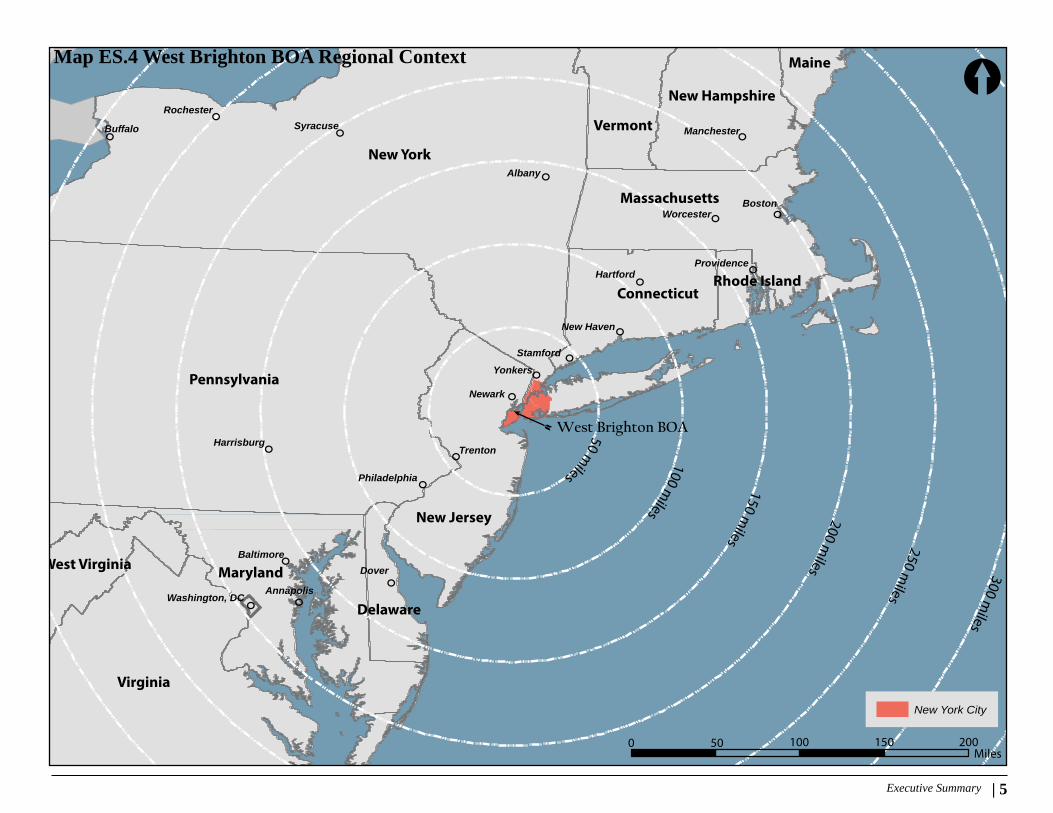
| 5 Executive Summary
New York
Pennsylvania
Virginia
Maryland
New Jersey
Massachusetts
Vermont
New Hampshire
Maine
Connecticut
West Virginia
Delaware
Rhode Island
100 miles 200 m
iles
250 miles
150 miles
50 miles
300 miles
Dover
Newark
Boston
Albany
Yonkers
Trenton
Buffalo
Hartford
Stamford
Syracuse
New Haven
Annapolis
Baltimore
Worcester
Rochester
Providence
Washington, DC
Harrisburg
Manchester
Philadelphia
West Brighton BOA
New York City
[
0 50 100 150 200Miles
Map ES.4 West Brighton BOA Regional Context

6 | Executive Summary
multi-pronged public participation strategy consisted of:
Regular and targeted meetings with the BOA Steering Committee
The role of the BOA Steering Committee was to provide community input, review and comment on presentation materials prior to public meetings and to assist in public outreach in order to develop consensus regarding the final recommendations. WBCLDC hosted a series of Steering Committee meetings and individual discussions with members throughout the BOA planning process.
Stakeholder Outreach and Meetings
As part of the BOA planning process, the BOA team identified a wide range of stakeholders within the study area. The BOA team held ongoing meetings with these stakeholders to engage in discussions about critical planning issues within the BOA and build consensus on a vision for the future of West Brighton.
Transportation Workshops
In 2014, DCP hosted a series of workshops with a number of agencies and property owners to identify alternative scenarios that would provide a wider/straighter Richmond Terrace, pedestrian and bicycle connections, and protected BRT lanes/station areas that would also allow waterfront businesses to invest in job creation. Three workshops were held, with each focused on a major property along the waterfront through which the North Shore ROW is located.
Through these workshops, DCP was able to reach consensus with property owners and city agencies on a number of preferred alignment options for the BOA’s future transportation infrastructure.
Public Meetings
A series of public meetings were held through-out the BOA planning process. The first public meeting, an Open House, was held in April 2013. The purpose of this meeting was to intro-duce the NYS BOA program to the public and to present a comprehensive analysis of exist-ing conditions in the BOA. The second public meeting, a Visioning Workshop, was held in November 2014. The Visioning Workshop was intended to build consensus on a number of focused, preliminary planning and urban design recommendations.
Interactive Community Workshops
In addition to the Visioning Workshops, the BOA team led a series of small, pop-up interactive workshops at public gathering spaces over summer 2015, which allowed the team to bring planning directly to the community and include more West Brighton residents in the planning process. The workshop exercises were designed to gather specific insight to existing land use and infrastructure challenges of the West Brighton neighborhood and assist in building consensus for potential future rezoning efforts in West Brighton.
Conducting focused outreach for the three subareas within the BOA—West Brighton, New Brighton, and Jersey—Street provided the BOA team with insight to the local stakeholders’ vision for their neighborhood.
Image ES. 2 Transportation Workshop

| 7 Executive Summary
Conducting focused outreach for the three subareas within the BOA—West Brighton, New Brighton, and Jersey—Street provided the BOA team with insight to the local stakeholders’ vision for their neighborhood. The vision for New Brighton is a mixed-use corridor (residential and commercial) that features mid-rise buildings and connects the destinations at St. George and Snug Harbor, while preserving the waterfront views of the upland residential neighborhood. The community envisions Jersey Street as a walkable and safe corridor that features a diverse set of local retail uses and expanded community facilities, such as health, education, recreational, and job training
centers. The community vision for West Brighton includes new commercial spaces along Richmond Terrace for franchises and small businesses. The new retail spaces would support the surrounding industrial businesses and an expanded open space network that features both active and passive uses and new commercial uses that help reconnect the neighborhood with the waterfront.
Brownfield analySiS
The West Brighton BOA report includes an analysis of existing and historical land uses in the study area. This analysis has
identified 41 sites within the study area as having potential environmental issues (Map ES.4). Twenty-four lots within the BOA area classified as a New York State Open Petroleum Spill Location, New York State Petroleum Bulk Storage Site, and/or a New York State Chemical Bulk Storage Sites, and fourteen lots within the study area present an historical use that could have potentially caused contamination on the site. Two lots in the study area have a New York City Environmental (E) designation (Appendix B). Properties with an NYC Environmental designation need to satisfy environmental requirements pertaining to potential hazardous materials contamination, high ambient noise levels, or air emission concerns.
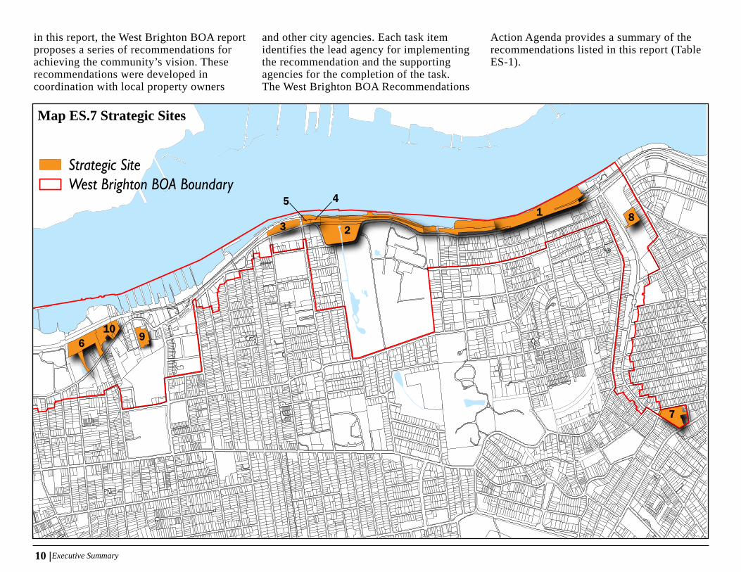
Strategic Site Selection
By using the selection criteria listed in the New York State Department of State’s Guidance for Brownfield Opportunity Area Applicant, the West Brighton BOA team identified 10 brownfield, underutilized, or vacant sites whose strategic redevelopment presents a unique opportunity to achieve the community’s vision and revitalization of the area (Map ES.5). The criteria used for the strategic sites include the following: size, location, community support, owner willingness, capacity for redevelopment, catalyst for the revitalization of the surrounding community, and potential to improve quality of life or public amenities.
recommendationS
As a result of the extensive public outreach and existing conditions analysis conducted
Image ES. 3 Public Meeting

8 | Executive Summary
RICHMOND TERRACE
BROADWAY
BARD
AVENUE
HOYT
AVENUE
ALASKA
STREET
CLOVE
ROAD
RICHMOND
TERRACE
BEMENT AVENUE
TAYLOR
STREET
SNUG HARBOR
ROAD
WAYNESTREET
BARKER STREET
ARLINGTON
COURT
KISSEL
AVENUE
WEST
STREET
DAVIS
AVENUE
LINDENSTREET
STATE
STREET
WALNUTSTREET
PELTON AVENUE
TAYLOR
COURT
HENDERSON AVENUE
NORTH MADA
AVENUE
NORTH
BURGHER
AVENUE
REGAN
AVENUE
OAKLAND AVENUE
MARKETSTREET
CAMPBELL
AVENUE
BARD
AVENUE
CASTLETON AVENUE
TRINITY PLACE
DONGAN
STREET
BRITTON STRE
ET
AMELIA COURT
DONALD PLACE
DELAFIELD PLACE
LIVINGSTON C
OURT
STEBBINS AVE
NUE
MOODY PLACE
ROKEBY PLACE
ELM STREET
West Brighton BOA BoundaryPotential BrownfieldVacant Land
0 0.50.25Miles [
Map ES.5 Potential Brownfield Sites - West Brighton Subarea

| 9 Executive Summary
Map ES.6 Potential Brownfield Sites - New Brighton and Jersey Street Subareas
ST
PETERS
PLACE
EAST BUC
HANAN
STREET
BUTLER
TERRACE
RICHMONDTERRACE
PORTLAND
PLACE
ARNOLD
STREET
CASSIDY PLACE
JERSEYSTREET
H
IGHVIEW
AVENUE
AVONPLACE
WEBSTER
AVENUE
FTHILL
PARK
FORT
PLACE
TOMPKINS
CIRCLE
VICTORY
BOULEVARDN
ORTH
RANDALL
AVENUE
HENDERSON AVENUE
FT
HILL
CIRCLE
BROOKSTREE
T
PENDLE
TON
PLAC
E
PROSPECT
AVENUE
PROSPECT AVENUE
BRIGHTONAVENUE
PENBROKE AVENUE
DANIELLOW
TER
RACE
FIEDLERAVENUE
EADIE
PLACE
KIRBY COURT
DUANE
COURT
CORSON AVE
NUE
ST MARKSPLACE
CARROLLPLACE
PHELPS
PLACE
WESTERVELT
AVENUE
ROBERT LANE
TYSEN
STREET
BENZIGER
AVENUE
FILLMORE STREETCRESCENT
AVENUE
RICHMONDTERRACE
PARKPLACE
EGMONT
PLACE
BISMARK
AVENUE
FREMONT
STREET
LAYTON AVENU
E
LAFAYETTE
AVENUE
FRANKLIN
AVENUE
ASTLETON
AVENUE
SHERMAN
AVENUE
TRUMBULL
PLACE
CORTELYO
U
PLACE
SNUG HARBORGREENWAY
ALDEN
PLACE
FTHILL
CIRCLE
BRENTWOOD
AVENUE
PIKE
STREET
Y
H
ARVARD
A
VENUE
NASSAU
STREET
CHESTNUT
PLACE
WARD
AVENUE
LOIS
PLACE
BEECHWOOD
AVENUE
DEVON
PLACE
SUMNER PLACE
PLACE
CALDERA PLACE
TAFTAVENU
E
CLINTON
AVENUE
CURTIS PLACE
HENDRICKS
AVENUE
EDGAR TERRACE
WILLIS
AVENUE
WESTBUCH
ANAN
STREET
BENZIGER A
VENUE
VAN BUREN
STREET
SCRIBNER AVENU
E
WINTER AVENU
E
VALENCIA AVENUE
West Brighton BOA BoundaryPotential BrownfieldVacant Land
0 0.50.25Miles [
10 |Executive Summary
in this report, the West Brighton BOA report proposes a series of recommendations for achieving the community’s vision. These recommendations were developed in coordination with local property owners
and other city agencies. Each task item identifies the lead agency for implementing the recommendation and the supporting agencies for the completion of the task. The West Brighton BOA Recommendations
Action Agenda provides a summary of the recommendations listed in this report (Table ES-1).
1 8
7
3
5 4
2
6 910
Strategic SiteWest Brighton BOA Boundary
Map ES.7 Strategic Sites

| 11 Executive Summary
Recommendation Implementation Lead Agency Supporting Agencies and Stakeholders
Explore a zoning proposal to promote mixed-use development of medium- to high-density with market-rate and affordable housing along the south side of Richmond Terrace between Jersey St. and Snug Harbor
DCP DOT, SCA, DEP, DPR
Assist with conducting Environmental Site Assessments for strategic brownfield sites to advance remediation efforts and future redevelopment opportunities
OER DCP, NYSDOS
Investigate potential street improvements on Richmond Terrace between Jersey Street and Lafayette Avenue to improve access to and through the corridor
DOT DCP, NYCEDC, DEP
Recommendation Implementation Lead Agency Supporting Agencies and StakeholdersExplore land swap proposal with property owners to facilitate development, improve mobility, and provide safe access to area parks and open spaces
NYCEDC MTA/NYCT, DOT, DCP, FTA, Property Owners
Advance the environmental review and design process for the North Shore Bus Rapid Transit (BRT) proposal MTA/NYCT DOT, DCP, NYCEDC, FTA, DPR, Property Owners
Recommendation Implementation Lead Agency Supporting Agencies and Stakeholders
Advance relocation and construction of new site for DSNY Garage DSNY DPR, NYCEDC, DCP
Advance redevelopment plans for DSNY Garage site that encourages a diversity of uses, including residential, commercial, and community facilities
NYCEDC DCP, DSNY, DPR, HPD
Explore zoning proposal with property owners, community stakeholders, and related city agencies for strategic development sites that support existing public and private affordable housing sites
DCP NYCHA, NYCEDC
Assist with conducting Environmental Site Assessments for strategic brownfield sites to advance remediation efforts and future redevelopment opportunities
OER OER, NYSDOS
Encourage redevelopment of existing private sites to provide additional housing, retail, and services by fully utilizing the existing zoning on Jersey Street
DCP HPD, NYCHA, SBS, NYCEDC
Recommendation Implementation Lead Agency Supporting Agencies and StakeholdersExplore zoning proposal to promote the expansion or creation of new commercial uses along Richmond Terrace DCP DOT, DEP, SBS, NYCEDC
Encourage use of FRESH zoning incentives to attract fresh food stores to underserved areas DCP
Supp
ort a
nd C
reat
e N
eigh
borh
ood
Cen
ters
West Brighton BOA Recommendations1. Create a mixed-use corridor along Richmond Terrace in New Brighton
2. Relocate Segments of the former North Shore Railroad Right-of-Way to improve transit to North Shore Neighborhoods
3. Support a mixed-use corridor on Jersey Street
4. Encourage commercial uses along Richmond Terrace in West Brighton
Table ES.1 West Brighton BOA Recommendations Action Agenda

12 |Executive Summary
Recommendation Implementation Lead Agency Supporting Agencies and Stakeholders
Explore a zoning proposal to promote mixed-use development of medium- to high-density with market-rate and affordable housing along the south side of Richmond Terrace between Jersey St. and Snug Harbor
DCP DOT, SCA, DEP, DPR
Assist with conducting Environmental Site Assessments for strategic brownfield sites to advance remediation efforts and future redevelopment opportunities
OER DCP, NYSDOS
Investigate potential street improvements on Richmond Terrace between Jersey Street and Lafayette Avenue to improve access to and through the corridor
DOT DCP, NYCEDC, DEP
Recommendation Implementation Lead Agency Supporting Agencies and StakeholdersExplore land swap proposal with property owners to facilitate development, improve mobility, and provide safe access to area parks and open spaces
NYCEDC MTA/NYCT, DOT, DCP, FTA, Property Owners
Advance the environmental review and design process for the North Shore Bus Rapid Transit (BRT) proposal MTA/NYCT DOT, DCP, NYCEDC, FTA, DPR, Property Owners
Recommendation Implementation Lead Agency Supporting Agencies and Stakeholders
Advance relocation and construction of new site for DSNY Garage DSNY DPR, NYCEDC, DCP
Advance redevelopment plans for DSNY Garage site that encourages a diversity of uses, including residential, commercial, and community facilities
NYCEDC DCP, DSNY, DPR, HPD
Explore zoning proposal with property owners, community stakeholders, and related city agencies for strategic development sites that support existing public and private affordable housing sites
DCP NYCHA, NYCEDC
Assist with conducting Environmental Site Assessments for strategic brownfield sites to advance remediation efforts and future redevelopment opportunities
OER OER, NYSDOS
Encourage redevelopment of existing private sites to provide additional housing, retail, and services by fully utilizing the existing zoning on Jersey Street
DCP HPD, NYCHA, SBS, NYCEDC
Recommendation Implementation Lead Agency Supporting Agencies and StakeholdersExplore zoning proposal to promote the expansion or creation of new commercial uses along Richmond Terrace DCP DOT, DEP, SBS, NYCEDC
Encourage use of FRESH zoning incentives to attract fresh food stores to underserved areas DCP
Supp
ort a
nd C
reat
e N
eigh
borh
ood
Cen
ters
West Brighton BOA Recommendations1. Create a mixed-use corridor along Richmond Terrace in New Brighton
2. Relocate Segments of the former North Shore Railroad Right-of-Way to improve transit to North Shore Neighborhoods
3. Support a mixed-use corridor on Jersey Street
4. Encourage commercial uses along Richmond Terrace in West Brighton
Recommendation Implementation Lead Agency Supporting Agencies and StakeholdersEncourage the expansion of commercial uses to support maritime jobs and businesses DCP NYCEDC
Advance strategies of DCP’s Resilient Industry study to reduce flood hazards for businesses, identify emergency preparedness guidelines, and identify regulatory and financial tools that encourage shoreline improvements and flood mitigation measures
DCP NYCEDC
Explore a potential expansion of available mooring space for maritime businesses at off-shore areas of city-owned properties SBS DCAS, DPR
Explore creation of a maritime training facility NYCEDC DCP, DOE
Recommendation Implementation Lead Agency Supporting Agencies and Stakeholders
Explore land swap proposal with property owners to remove RR ROW from maritime property to allow for business expansion and job creation NYCEDC MTA/NYCT, DOT, DCP, FTA, Maritime Property Owners
Evaluate transit improvement alternatives, including the proposed MTA Bus Rapid Transit Plan, expanded bus service and others MTA/NYCT DOT, DCP, NYCEDC, FTA, DPR, and Maritime Property Owners
Recommendation Implementation Lead Agency Supporting Agencies and StakeholdersDependent upon MTA’s advancing of their BRT proposal, explore zoning proposal with property owners, local stakeholders, and related city agencies to expand commercial opportunities near a proposed BRT station
DCP MTA/NYCT, DOT, NYCEDC, SIEDC, WBCLDC
Cre
ate
Qua
lity
Jobs
and
Wor
kpla
ces
1. Support maritime industry
2. Relocate the former North Shore Railroad ROW to support job creation
3. Expand commercial uses near the MTA-proposed BRT station in West Brighton

| 13 Executive Summary
Recommendation Implementation Lead Agency Supporting Agencies and StakeholdersImprove public waterfront access at Snug Harbor waterfront DPR DCP, DCA, DOT, MTA/NYCTEnsure future North Shore Greenway development provides access to Snug Harbor and Heritage Park DOT DPR, MTA/NYCT, DCP
Explore potential bicycle and pedestrian connections from upland neighborhoods to Heritage Park, including dedicated crosswalks on Richmond Terrace
DOT DCP, DPR
Investigate options for expanding Heritage Park using publically-owned land DPR DCP, DOT, MTA/NYCT
Coordinate the potential reconstruction Snug Harbor ferry dock to generate revenue for and increase access to Snug Harbor and surrounding sites in the BOA
NYCEDC Snug Harbor, DOT, DCA, NYCEDC, SBS
Investigate options for closure of Bard Avenue street end to provide public open space under DOT plaza program DOT DCP, MTA/NYCT
Recommendation Implementation Lead Agency Supporting Agencies and StakeholdersExplore appropriate alignment for proposed Greenway to facilitate land swaps with property owners affected by present location of North Shore RR ROW
DOT NYCEDC, MTA/NYCT, DPR, DCP, FTA, Maritime Property Owners
Ensure planned Bank Street bicycle and pedestrian path (North Shore Greenway Phase 1) provides connection to Richmond Terrace and points beyond
DOT DOT, DPR, DCP, NYCEDC, Property Owners
Explore potential street improvements, including bicycle and pedestrian infrastructure, on Richmond Terrace from Jersey Street to Lafayette Avenue to accommodate traffic connections and future rezonings
DOT MTA/NYCT, DCP
Explore pedestrian and bicycle improvements along the Snug Harbor waterfront as part of the North Shore Greenway proposal DOT MTA/NYCT, DPR, Snug Harbor
Identify appropriate location for the proposed North Shore Greenway from Snug Harbor to Heritage Park DOT MTA/NYCT, NYCEDC, DCP, DPR
Recommendation Implementation Lead Agency Supporting Agencies and Stakeholders
Explore zoning tools that permit transparent fencing at appropriate locations while maintaining secure facilities to ensure community awareness of industrial activities in their neighborhood
DCP NYCEDC, Maritime businesses
At street ends, coordinate with maritime businesses to encourage the installation transparent fencing to allow views of maritime activity and maintain on-site security
DCP NYCEDC, Maritime businesses
Explore public/private partnerships to maintain city-owned and vacant waterfront properties and to preserve waterfront view corridors NYCEDC DPR, MTA/NYCT, DCAS, DOT
Impr
ove
acce
ss to
wat
erfr
ont,
park
s, an
d op
en sp
ace
1. Create publicly accessible waterfront parks and destinations
2. Advance planning for a North Shore Greenway
3. Promote and protect working waterfront views and maritime overlooks

14 |Executive Summary
Recommendation Implementation Lead Agency Supporting Agencies and StakeholdersExplore potential land swap proposals with property owners to create a transitway running contiguous to Richmond Terrace NYCEDC MTA/NYCT, DOT, DCP, FTA, DPR, Property Owners
Advance environmental review and engineering study for proposed Bus Rapid Transit system MTA/NYCT DOT, NYCEDC, DPR, DCP
Identify appropriate BRT station locations MTA/NYCT DOT, NYCEDC, DPR, DCP
Recommendation Implementation Lead Agency Supporting Agencies and StakeholdersImplement recommendations of North Shore Transportation Improvement Strategy DOT MTA/NYCT, NYCEDC, DCP
Explore land swap proposals to allow straightening of hazardous curves on Richmond Terrace at Bement Avenue and Broadway intersections DOT NYCEDC, DCAS, Property Owners
Explore potential designs for the construction of street improvements on city-owned portion of Richmond Terrace between Jersey Street and Lafayette Avenue to improve traffic flow and safety
DOT MTA/NYCT, DCP
Investigate the potential of implementing the proposed North Shore Greenway - Pedestrian and Bicycle amenities on Richmond Terrace from Jersey Street to Snug Harbor
DOT MTA/NYCT, DPR, Snug Harbor
Investigate the potential of implementing the proposed North Shore Greenway - Pedestrian and Bicycle path along Snug Harbor waterfront DOT MTA/NYCT, NYCEDC, DCP, DPR, Snug Harbor
Recommendation Implementation Lead Agency Supporting Agencies and Stakeholders
Explore locations for additional signalized intersections on Richmond Terrace to promote safe driving speeds and pedestrian safety DOT MTA/NYCT
Implement sidewalk improvements along Richmond Terrace to create safe pedestrian routes that would also support existing businesses and future redevelopment
DOT MTA/NYCT, NYCEDC
Explore wayfinding options for improved visibility of area destinations, including Snug Harbor and Heritage Park DOT Snug Harbor, DPR, NYCEDC
Provide bicycle lanes from upland neighborhoods to Richmond Terrace and waterfront destinations and open spaces DOT DPR
Limit curb cuts on Richmond Terrace at new development sites in New Brighton to limit traffic congestion and conflicts between pedestrian, bicyclists and drivers
DOT DCP
Impr
ove
Con
nect
ions
and
Mob
ility
1. Support the implementation of the MTA North Shore Bus Rapid Transit Proposal
2. Coordinate MTA North Shore BRT planning with transportation and streetscape improvements on the North Shore
3. Improve safety for pedestrians, bicyclists and drivers

| 15 Executive Summary
Recommendation Implementation Lead Agency Supporting Agencies and StakeholdersAdvance DCP’s Resilient Industries strategies for reducing flood risks to industrial uses DCP ORR, OEM
Advance the expansion of the Bluebelt to Snug Harbor to reduce flooding concerns DEP DPR, Snug Harbor
Recommendation Implementation Lead Agency Supporting Agencies and Stakeholders
Identify contamination issues on brownfield and strategic sites by working with property owners and matching them to funding sources for Environmental Site Assessments to determine if cleanup is necessary
OER NYCEDC, ORR
Explore a zoning proposal to promote redevelopment and the construction of new mixed-use resilient buildings on strategic brownfields in New Brighton
DCP OER, ORR, NYCEDC
Explore zoning and redevelopment proposals for Jersey Street DCP NYCHA, NYCEDC, HPD, OER
Advance relocation of DSNY Garage at Jersey Street DSNY NYCEDC, OER
Add
ress
Env
iron
men
tal C
halle
nges
1. Improve climate resilience in flood-prone areas
2. Clean up brownfield sites

16 |1: Project Description and Boundary
tant in community outreach and to complete all phases of the Nomination Report.
1.2 Project overview and descriPtion
The West Brighton BOA encompasses North Shore neighborhoods whose identities were shaped by their relationship to the New York Harbor waterfront and its maritime history. From its early days as a fishing site for local Native American tribes, to the Victorian-era when it welcomed ferries carrying wealthy Manhattanites seeking respite from the summer heat, to finally, its development into a major maritime and industrial center, the waterfront has shaped the local economy and quality of life. However, the departure of maritime uses and the challenge of maintaining waterfront infrastructure have left the community with limited public access to the waterfront and un-inviting public areas. In addition, environmental concerns and a changing economic landscape threaten the livelihood of those who live, work and play in West Brighton, and a new communi-ty vision for the area is needed. The BOA study represents the next step in a community-driven planning process to re-imagine West Brighton as a waterfront community where thriving and healthy communities coexist harmoniously with a truly 21st century maritime and industrial economy.
The West Brighton BOA encompasses only a two-mile portion of Staten Island’s five-mile North Shore waterfront. The North Shore,
1.1 Lead Project sPonsors
The New York State Department of State (DOS) develops and maintains the statewide Brown-field Opportunities Area (BOA) Program in order to help communities affected by the pres-ence of contaminated sites, or the perception thereof, to develop consensus-driven revitaliza-tion strategies. The West Brighton Community Local Development Corporation (WBCLDC), representing the eastern half of Staten Island’s North Shore, initiated the BOA work program in 2005. Following the successful completion of a Phase 1 BOA Pre-Nomination Report in 2009, WBCLDC secured funding from the DOS to begin work on a Phase 2 Nomination Re-port in 2011. In 2012, WBCLDC selected and contracted with the New York City Department of City Planning (DCP) to be the lead consul-
1 | Project Description and Boundary
Image 1.1 Caddell Dry Dock and Repair

| 17 1: Project Description and Boundary
stretching from St. George in the east to How-land Hook in the west, and extending inland one mile, is defined by its waterfront. At its eastern edge, the North Shore is bounded by the Narrows, a tidal strait that connects the Up-per and Lower New York Bays and separates Staten Island from the borough of Brooklyn. The Narrows form the entry point to the ports of New York and New Jersey and has guaran-teed the North Shore a prominent place in the region’s strong maritime industry. The bulk of that maritime industry is located along the Kill Van Kull, a tidal strait that connects the Nar-rows with the vast port infrastructure of Staten Island’s West Shore and New Jersey, the largest on the American East Coast. The entire West Brighton BOA waterfront is located on the Kill Van Kull, making this heavily trafficked water-
way the area’s defining physiological, maritime and industrial characteristic. To the west of the BOA study area are the North Shore communi-ties of Port Richmond, Arlington and Mariner’s Harbor, which are the subject of a separate DOS BOA Study. Both BOA study areas are being coordinated to ensure that common goals can be obtained through consistent recommendations. To the south, the study area sweeps upland toward a long ridgeline that stretches from St. George inland to Todt Hill, the highest point in New York City.
The geographical profile of the BOA study area – sloping upland communities and an extensive shoreline – has made it an important location throughout the history of the region and New York City. Artifacts found on Staten Island sug-
gest that Pre-European communities occupied the North Shore since 10,000 BC and relied heavily upon the abundant wildlife and sea-food, particularly shellfish found along the Kill Van Kull shoreline. European explorers and settlers took advantage of the North Shore’s water resources by establishing trade outposts in what is now Tompkinsville, one mile south-east of the BOA study area. As European settlement of Staten Island and the surrounding region expanded, farmsteaders were attracted to the North Shore by the area’s good soil as well as opportunities for regional trade that the Kill Van Kull afforded. This early maritime industry – the transporting of farm goods to the surrounding region – remained through the eighteenth century. However, as New York City grew to be a major economic center in ear-ly America, the North Shore, with its sweeping waterfront vistas and proximity to Manhattan, became a desired location for country homes of the city’s wealthy classes. In the first two decades of the nineteenth century, a number of large summer homes were built directly on the Kill Van Kull shoreline. Sailors’ Snug Harbor, a home for retired sailors that would eventually become the wealthiest charitable organization in the United States, was built one mile west of St. George.
With the advent of the industrial revolution in the United States, however, the North Shore began its transformation into a major industrial and maritime center. The extent of industrial development in the nineteenth century was so robust that West Brighton became known as “Factoryville.” Both manufacturing and mar-itime businesses came to dominate the North Shore waterfront. Along with the prosperity of industrial operations on the North Shore came a railroad, ferry terminals, and other urban
Image 1.2 Industrial East and North Shore, 1930 (From the Collection of the Staten Island Museum)