Embed Size (px)
Citation preview
Welcome to “On the Hudson”

• What is the source of water for your school? Your home? Do you know the name of the watershed you live in?
• Name some common “uses” of water for you personally? Commercially in your town?
• What would you guess about your water quality? Is it good? Bad? Somewhere in between?
• Name one major threat to your water quality in your town?
http://landresources.montana.edu/watershed/images/Streampainting.jpg
What is your watershed address?

…a region of land that contributes water to a stream, river, pond, or other body of water.
www.riversofalabama.org
A Watershed is…

Q1: What is the largest source of pollution in watersheds?
15%
25%
60%
0% 1. Oil spills from vessels and ports
2. Storm water runoff
3. Industrial outfalls
4. Atmospheric deposition
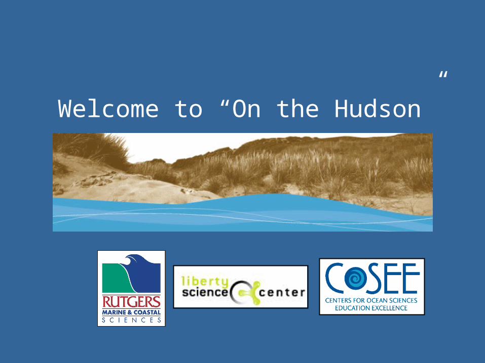
http://www.co.shasta.ca.us/Departments/PublicWorks/Watershed%20Model.jpg
Activity 1Watershed Model

Each watershed can be classified based on its:
• Geography
• Climate
• Vegetation
No two watersheds are exactly alike

The Hudson River Watershed
http://ny.water.usgs.gov/projects/hdsn/
• Comprises about 13,400 mi2. That’s Almost twice the size of NJ.
• 93% lies within NY state• Includes parts of 35 counties
Divided into three major sub-basins:
• Upper Hudson (4,600)• Mohawk river (3,500)• Lower Hudson (5,200)

The Hudson River
http://ny.water.usgs.gov/projects/hdsn/
• Flows 315 miles from Mt. Marcy to the southern tip of Manhattan where it empties into the Atlantic Ocean
• Tributaries to the Hudson include 6,077 stream miles

Upper Hudson Geography
• The Hudson starts at Lake Tear of the Clouds in the Adirondack Mountains, 4,322 feet above sea level
• The northern half of the river is freshwater fed by snowmelt, groundwater and rain
• From Hudson Falls to Albany the river depth is maintained at 12 feet for commercial traffic

Q2: How much of the Hudson river, which is 315 miles in length, is tidal?
http://ny.water.usgs.gov/pubs/wri/wri994024/wrir99-4024.pdf
47%
16%
26%
11%
0% 1. To the Battery (0 miles)
2. To the Tappan Zee Bridge (27 miles)
3. To West Point (52 miles)
4. To Poughkeepsie (77 Miles)
5. To Troy (154 miles)

The Hudson Tidal Estuary
• The Hudson tidal estuary makes up the lower half of the Hudson River, spanning 154 miles from the tip of the Battery to the Federal Dam north of Troy.
• The lower Hudson can undergo a reversal in the direction of flow 4 times a day.
• This section of the river experiences dramatic changes in salinity, circulation patterns, tidal ranges, river width and water depth, fish species, macro-invertebrate communities, and plant communities.
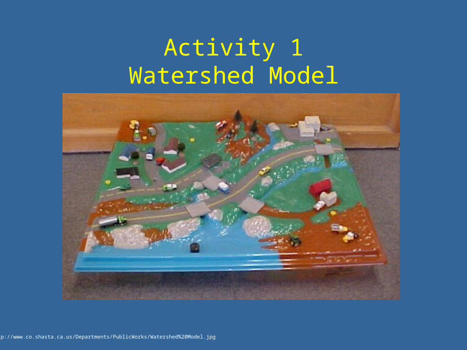
• The southern estuary section is a tidal mix of salty seawater and freshwater
• This stretch has been said to "flow both ways" because of tidal influence
• Mean water elevation at Albany is 4 feet above sea level
• Widens to 3.5 miles near Haverstraw, but narrows again as it passes the Palisades
• The river is kept at at least 32 feet, but is as deep as 200 feet in some places
Lower Hudson Geography
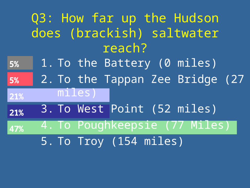
Q3: How far up the Hudson does (brackish) saltwater reach?
47%
21%
21%
5%
5% 1. To the Battery (0 miles)
2. To the Tappan Zee Bridge (27 miles)
3. To West Point (52 miles)
4. To Poughkeepsie (77 Miles)
5. To Troy (154 miles)

The Hudson Salt Front• The salt front is the location of brackish
water (>1% salt)• Its position varies greatly with stream flow• During high flows in the spring (>50,000
ft3/s) the front is pushed south of the Tappan Zee Bridge
• In the summer when the discharge is minimum (~1,500 ft3/s) the salinity intrusion extends to the vicinity of Newburgh or higher
• Poughkeepsie relies on fresh water from the river and is severely affected when flows are extremely low and salt water reaches their pumping stations
7,000
3,500
70,000
35,000
140,000
18,000
Stream flow at TroyIn ft3/s
Poughkeepsie
Newburgh
Peekskill
Tarrytown
Yonkers
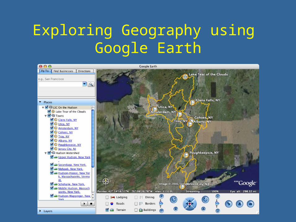
Exploring Geography using Google Earth
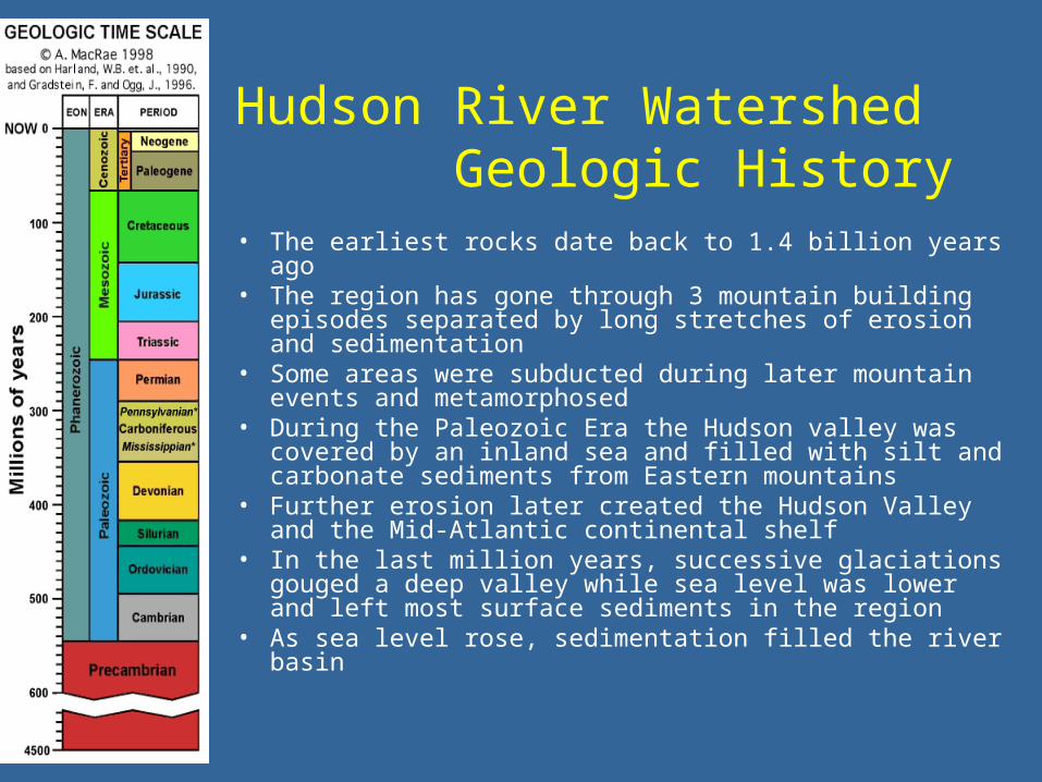
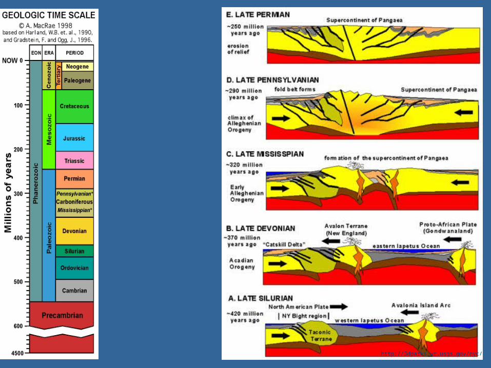
Hudson River Watershed Geologic History
• The earliest rocks date back to 1.4 billion years ago• The region has gone through 3 mountain building
episodes separated by long stretches of erosion and sedimentation
• Some areas were subducted during later mountain events and metamorphosed
• During the Paleozoic Era the Hudson valley was covered by an inland sea and filled with silt and carbonate sediments from Eastern mountains
• Further erosion later created the Hudson Valley and the Mid-Atlantic continental shelf
• In the last million years, successive glaciations gouged a deep valley while sea level was lower and left most surface sediments in the region
• As sea level rose, sedimentation filled the river basin

http://3dparks.wr.usgs.gov/nyc/
http://3dparks.wr.usgs.gov/nyc/

http://3dparks.wr.usgs.gov/nyc/

http://3dparks.wr.usgs.gov/nyc/
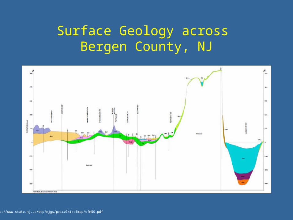
Surface Geology across Bergen County, NJ
http://www.state.nj.us/dep/njgs/pricelst/ofmap/ofm50.pdf
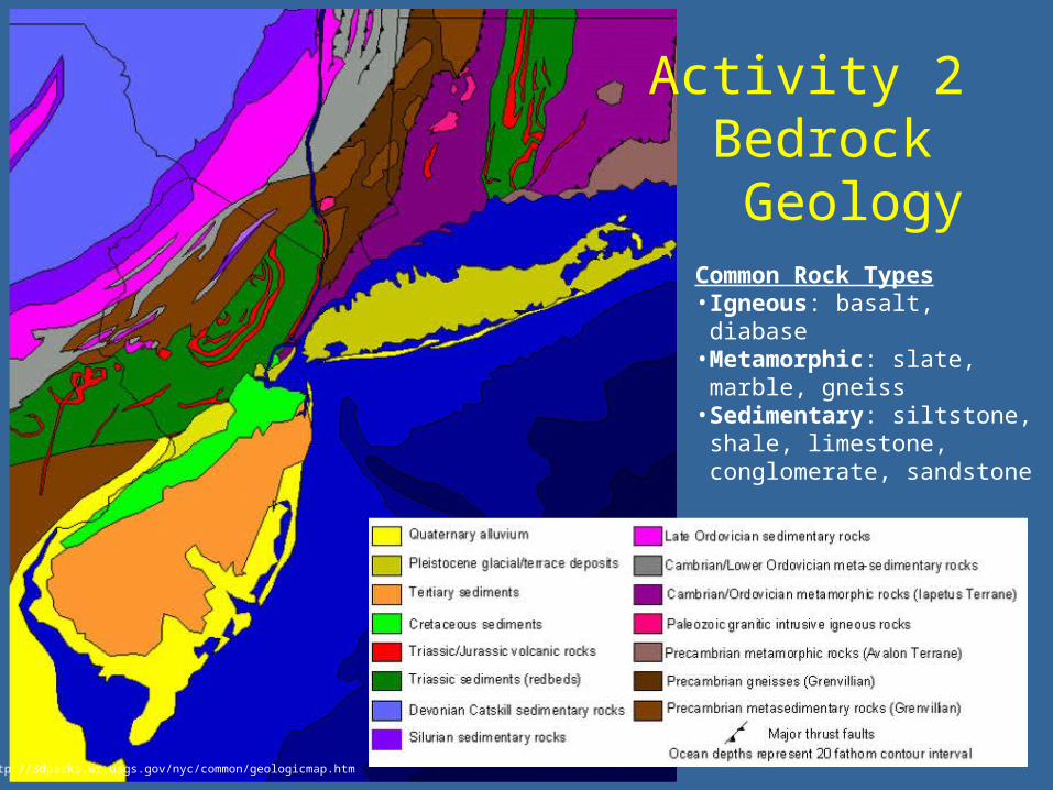
Activity 2Bedrock Geology
http://3dparks.wr.usgs.gov/nyc/common/geologicmap.htm
Common Rock Types• Igneous: basalt, diabase • Metamorphic: slate, marble,
gneiss• Sedimentary: siltstone, shale,
limestone, conglomerate, sandstone

Q4: What type of rock is most commonly found in the Hudson River
watershed?
76%
0%
24% 1. Basalt, Diabase & Gneiss (crystalline)
2. Limestone & Marble (carbonates)
3. Sandstone & Shale (clastic)

Hudson Valley Rock Types
Clastic or sedimentary rocks (I.e. sandstone and shale) are most common, though a thick layer of glacial sediments rests on the surface.
Water-Quality Assessment of the Hudson River Basin in New York and Adjacent States - Analysis of available nutrient, pesticide, volatile organic compound and suspended-sediment data, 1970-90: Phillips, P. J., and Hanchar, D. W., 1996, U.S. Geological Survey Water-Resources Investigations Report 96-4065, 76 p.
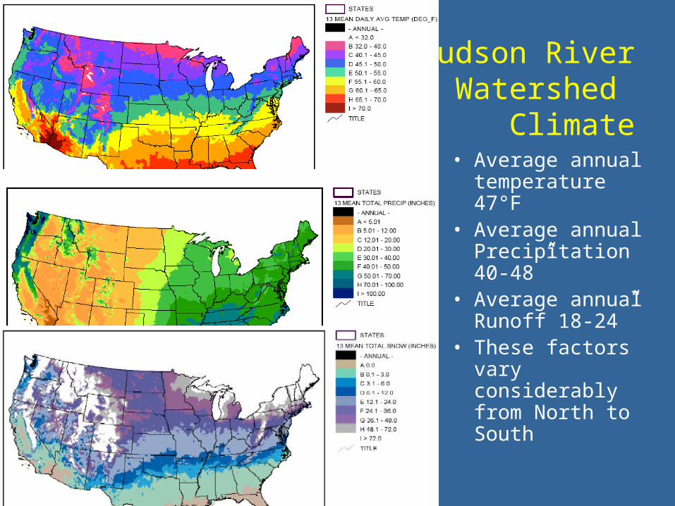
Hudson RiverWatershed
Climate• Average annual
temperature 47°F• Average annual
Precipitation 40-48”
• Average annual Runoff 18-24”
• These factors vary considerably from North to South
http://hurricane.ncdc.noaa.gov/cgi-bin/climaps/climaps.pl

Annual Climate in Troy, NY
http://www.city-data.com/city/Troy-New-York.html

Hudson River WatershedClimate
• Average stream flow at Federal Dam is 13,600 ft3/s, which includes 5,670 ft3/s from the Mohawk River
• But it can range from 1,500 ft3/s in the summer to over 70,000 ft3/s during the spring
http://ny.water.usgs.gov/projects/hdsn/fctsht/su.html#HDR0

Discharge and Precipitation in Poughkeepsie, NY
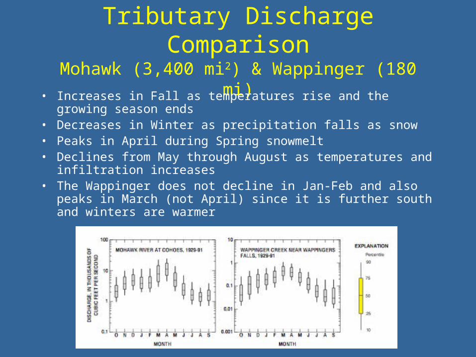
Tributary Discharge ComparisonMohawk (3,400 mi2) & Wappinger (180 mi)
• Increases in Fall as temperatures rise and the growing season ends
• Decreases in Winter as precipitation falls as snow• Peaks in April during Spring snowmelt• Declines from May through August as temperatures and
infiltration increases• The Wappinger does not decline in Jan-Feb and also peaks in
March (not April) since it is further south and winters are warmer

• Submerged Aquatic Vegetation - These rooted plants grow below the low tide level and provide a variety of benefits
• Marsh Communities - These plants range from being fully submerged during parts of the tidal cycle (low marsh) to growing just above the mean tidal line zone (high marsh). The tidal action brings in a constant influx of nutrients, suspending and resuspending them through tidal motion.
Hudson River WatershedPlants

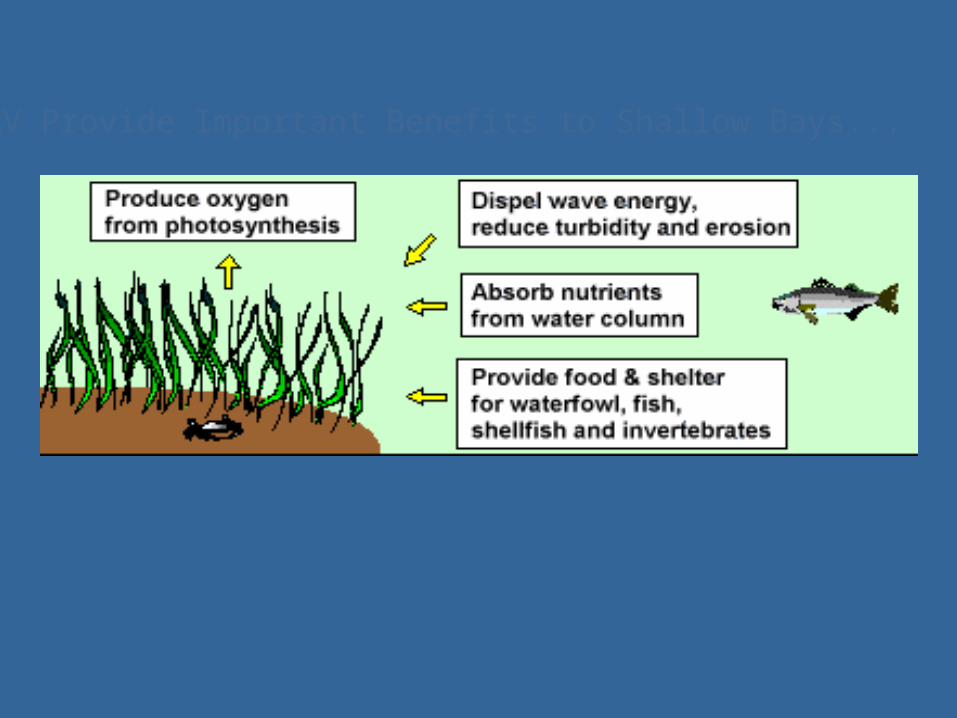
SAV Provide Important Benefits to Shallow Bays...

SAV Make Good Habitat!
•They provide food & shelter for waterfowl, fish, shellfish, and invertebrates.
Spider crab
Sea urchin
Young glass eels
Blue Crab
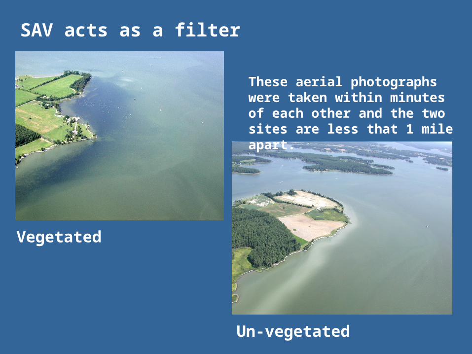
SAV acts as a filter
Vegetated
Un-vegetated
These aerial photographs were taken within minutes of each other and the two sites are less that 1 mile apart.

The Hudson River is full of a wide variety of fish and macroinvertebrates.
Hudson River Watershed
Animals

About 200 fish have been documented to live in the Hudson estuary for some or all portions of their lives throughout the year millions of fish, both marine and freshwater species, utilize the lower Hudson as a spawning, nursery and feeding ground.
Hudson River Watershed
Fish
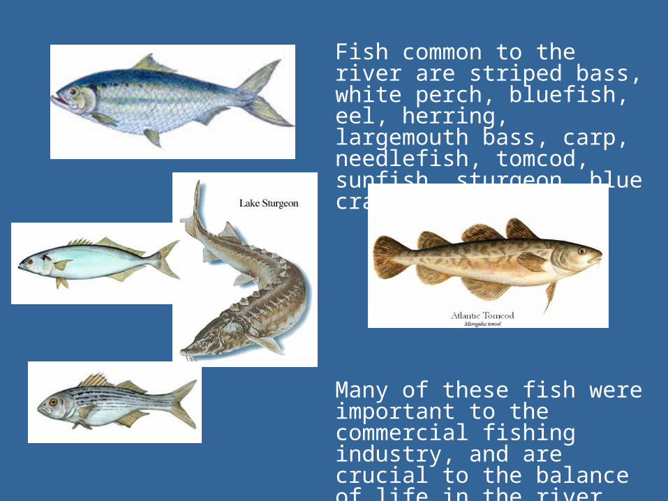
Fish common to the river are striped bass, white perch, bluefish, eel, herring, largemouth bass, carp, needlefish, tomcod, sunfish, sturgeon, blue crab and shad.
Many of these fish were important to the commercial fishing industry, and are crucial to the balance of life in the river.

Classifying Land Usein New York City
http://earthobservatory.nasa.gov/Newsroom/NewImages/images.php3?img_id=15368
From the TERRA satellite
• Vegetation is Green
• Water is Blue
• Manmade structures are gray

Q5: How much land in the Hudson watershed do you think can be
classified as Urban?1. 2%
2. 8%
3. 16%
4. 24%
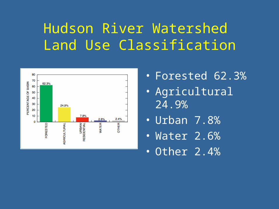
Hudson River Watershed Land Use Classification
• Forested 62.3%• Agricultural 24.9%• Urban 7.8%• Water 2.6%• Other 2.4%
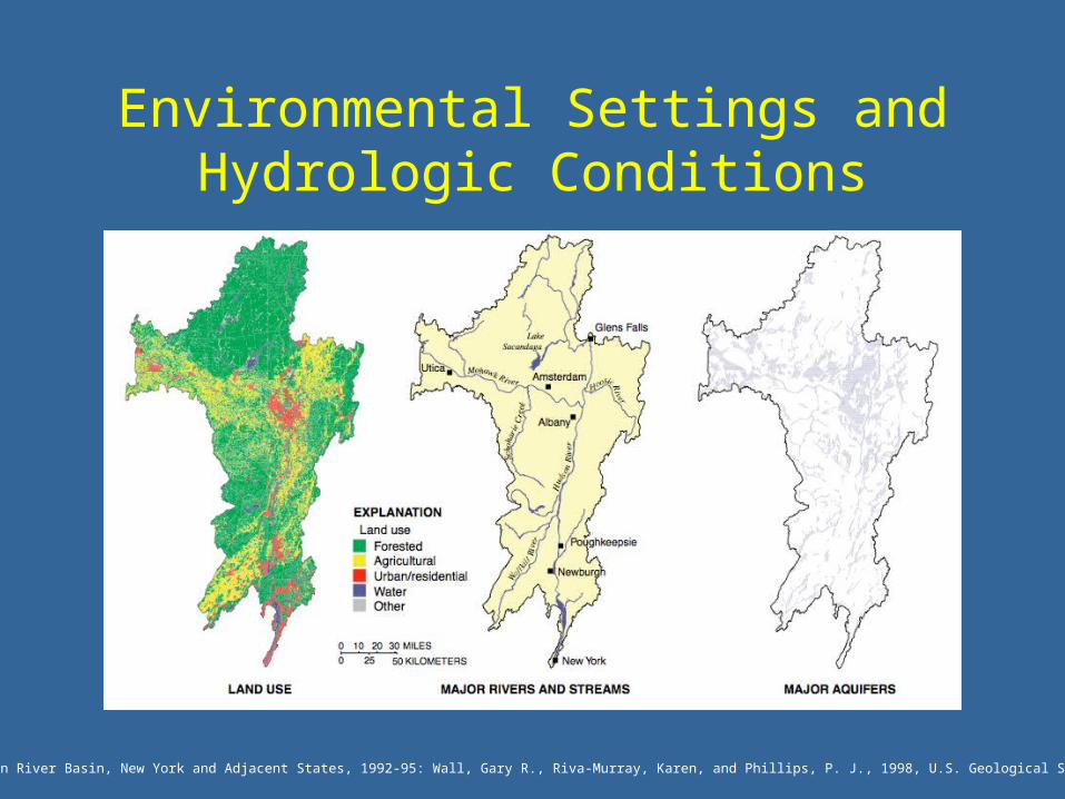
Environmental Settings and Hydrologic Conditions
Water Quality in the Hudson River Basin, New York and Adjacent States, 1992-95: Wall, Gary R., Riva-Murray, Karen, and Phillips, P. J., 1998, U.S. Geological Survey Circular 1165, 32 p.
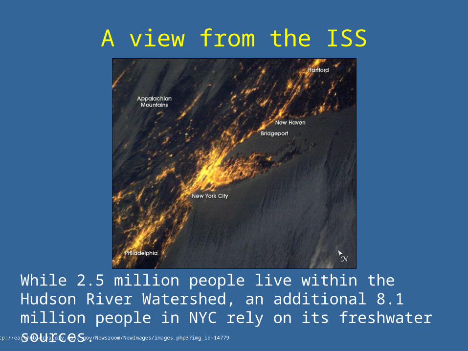
A view from the ISS
http://earthobservatory.nasa.gov/Newsroom/NewImages/images.php3?img_id=14779
While 2.5 million people live within the Hudson River Watershed, an additional 8.1 million people in NYC rely on its freshwater sources.
Q6: Why do scientists care about classifying land use?
1. Water quality assessment
2. Municipal planning (development)
3. Aquifer storage and recovery
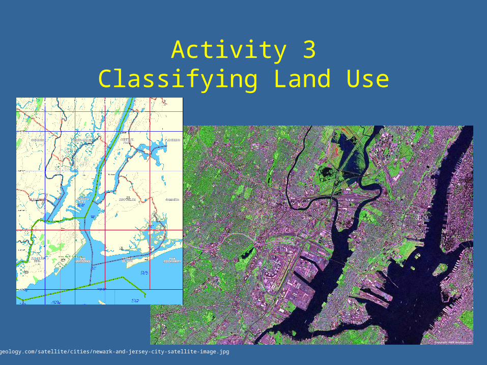
Activity 3Classifying Land Use
http://geology.com/satellite/cities/newark-and-jersey-city-satellite-image.jpg


Water-Quality Assessment of the Hudson River Basin in New York and Adjacent States - Analysis of available nutrient, pesticide, volatile organic compound and suspended-sediment data, 1970-90: Phillips, P. J., and Hanchar, D. W., 1996, U.S. Geological Survey Water-Resources Investigations Report 96-4065, 76 p.
Relation between Precipitation and Runoff