Embed Size (px)
Citation preview

Weiss, Rich, & Launer: Stream Temperature Characterization
Appendix 1. Hemispherical Photography Acquisition Protocol
Overview: When acquiring hemispherical canopy photographs in the field, the basic goal is to obtain high quality photographs. Good quality photographs result when sufficient care is taken to position, level, and orient the camera correctly, when the exposure is correct, when the sky lighting is very even, and when there are no bright reflections. High contrast images with even sky lighting are best obtained on days with evenly overcast skies, or, if this is not possible, early in the morning or late in the afternoon. Direct sunlight in the photograph is extremely undesirable. Supplies: Digital camera, hemispherical lens, self-leveling camera mount, monopod, data notebook, and pens or pencils. Protocol: 1. Set up the camera on the self-leveling mount, which will automatically cause it to point
directly upward. 2. Adjust the camera settings:
a. Set the aperture – it should be shut down as far as possible. b. Set the shutter speed – the default should be 125s (1/125 s). In a pinch 60 may be
used, although the difficulty of holding the camera steady for a long enough period of time will make it hard to obtain high-quality photographs.
c. Make sure the focus is set to infinity. 3. Although a digital camera will automatically record the photo number, date, and time you
should carry a notebook and note the photograph number and relevant data, such as location, height above ground, exposure settings, weather/sky conditions, and any problems.
4. Attach the camera/mount assembly to the monopod and set it to the appropriate horizontal position and height.
5. Using a compass, orient the camera so that magnetic north is located directly toward the top of the image.
6. Set the shutter release timer and get out of the field of vision (below lens). If the camera is close to the ground it may be necessary to crouch or lie down. The camera should have several minutes between the time when the timer is set and the time when the photograph is taken – this is to allow the camera to level itself completely.
7. Repeat steps 1-6.
A-1

Weiss, Rich, & Launer: Stream Temperature Characterization
Appendix 2. Water temperature over time during September 2006.
A-2

Weiss, Rich, & Launer: Stream Temperature Characterization
Appendix 2 (cont). Water temperature over time during September 2006.
A-3
Weiss, Rich, & Launer: Stream Temperature Characterization
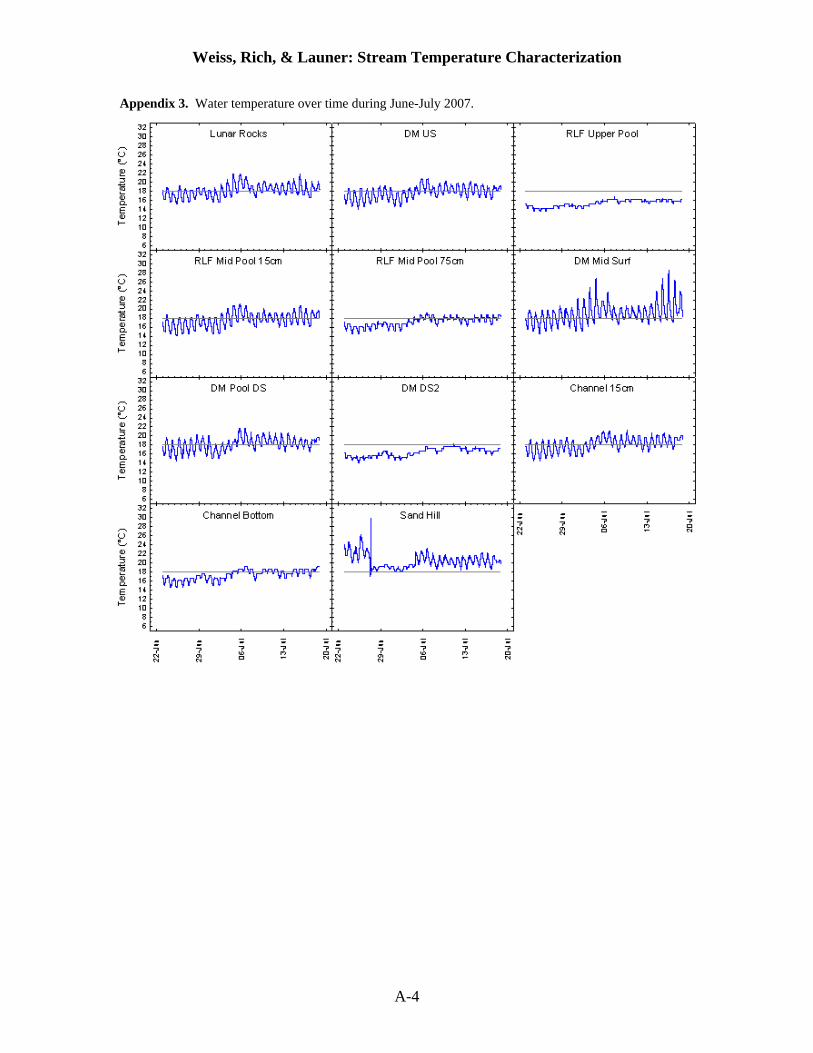
Appendix 3. Water temperature over time during June-July 2007.
A-4

Weiss, Rich, & Launer: Stream Temperature Characterization
Appendix 4. Water temperature over time during August 2007.
A-5

Weiss, Rich, & Launer: Stream Temperature Characterization
Appendix 4 (cont). Water temperature over time during August 2007.
A-6

Weiss, Rich, & Launer: Stream Temperature Characterization
Appendix 5. Daily water temperature regimes during September 2006.
A-7

Weiss, Rich, & Launer: Stream Temperature Characterization
Appendix 5 (cont). Daily water temperature regimes during September 2006.
A-8

Weiss, Rich, & Launer: Stream Temperature Characterization
Appendix 6. Daily water temperature regimes during June-July 2007.
A-9

Weiss, Rich, & Launer: Stream Temperature Characterization
Appendix 7. Daily water temperature regimes during August 2007.
A-10

Weiss, Rich, & Launer: Stream Temperature Characterization
Appendix 7 (cont). Daily water temperature regimes during August 2007.
A-11

Weiss, Rich, & Launer: Stream Temperature Characterization
Appendix 8. A) Locations of temperature sensors during June-July 2007. B) Maximum, mean, and minimum water temperature during June-July 2007. C) Locations of temperature sensors during August 2007. D) Maximum, mean, and minimum water temperature during August 2007.
A)
B)
A-12

Weiss, Rich, & Launer: Stream Temperature Characterization
C)
D)
A-13

Weiss, Rich, & Launer: Stream Temperature Characterization
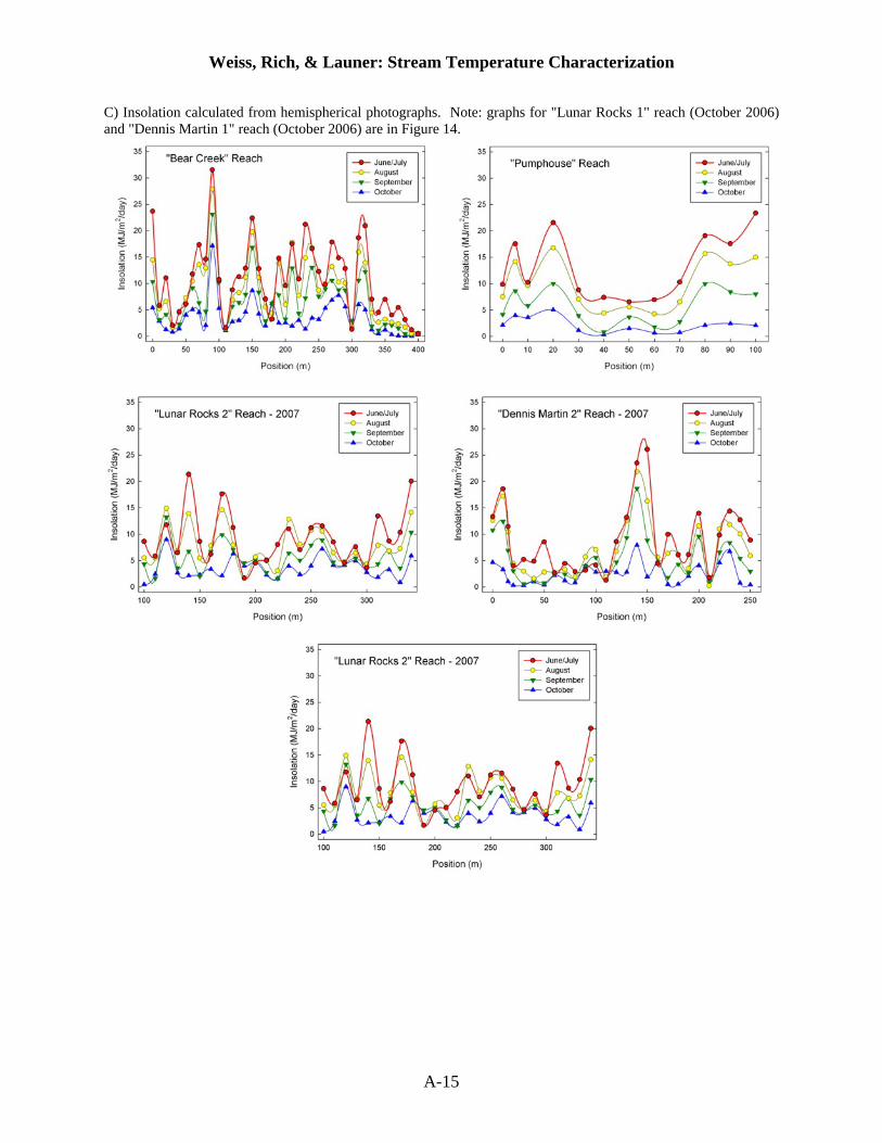
Appendix 9. San Francisquito Creek hemispherical photography A) transect locations, B) sampling details, and C) graphs of insolation.
A) Hemispherical photography transect locations.
B) Hemispherical photography transect sampling details.
Transect Sampling Date
Transect Length
(m)
Begin Point (m)
End Point (m)
Photo Spacing
(m)
Number of Photos
Photo Numbers
Bear Creek August 2007 400 0 400 10 41 345-385
Lunar Rocks 1 October 2006 100 0 100 2.5 42 (incl. 1 at 5 m
interval)
045-086
Lunar Rocks 2 August 2007 250 100 350 10 25 387-414; 388, 390,
396 missing
Dennis Martin 1 October 2006 100 -100 0* 2.5 41 003-044; 024
missing Dennis Martin 2 August 2007 250 0* 250 10 27 (incl. 1
at 5 m interval)
306-332
Pumphouse August 2007 100 0 100 10 12 (incl. 1 at 5 m
interval)
333-344
Los Trancos 1 October 2006 25 ** ** 2.5 11 087-097
* The beginning of the “Dennis Martin” 2007 transect is located approximately 30 m downstream of the end of the “Lunar Rocks” transect at 350 m. ** The “Los Trancos” transect begins immediately downstream of Ladera Bridge and continues for 100m downstream.
A-14
Weiss, Rich, & Launer: Stream Temperature Characterization
C) Insolation calculated from hemispherical photographs. Note: graphs for "Lunar Rocks 1" reach (October 2006) and "Dennis Martin 1" reach (October 2006) are in Figure 14.
A-15
Weiss, Rich, & Launer: Stream Temperature Characterization
Appendix 10. References concerning stream water temperature and related topics. Stream Organisms of Conservation Concern Crisp, D.T. 1990. Water temperature in a stream gravel bed and implications for salmonid
incubation. Freshwater Biology 23 (3):601-612. Ebersole, J.L., W.J. Liss, and C.A. Frissell. 2003. Thermal heterogeneity, stream channel
morphology, and salmonid abundance in northeastern Oregon streams. Canadian Journal of Fisheries and Aquatic Sciences 60:1266-1280.
Fellers, G.M., A.E. Launer, G. Rathbun, S. Bobzien, J. Alvarez, D. Sterner, R.B. Seymour, and M. Westphal. 2001. Overwintering tadpoles in the California Red-Legged Frog (Rana aurora draytonii). Herpetological Review 32 (3):156-157.
Halverson, M.A., D.K. Skelly, J.M. Kiesecker, and L.K. Freidenburg. 2003. Forest mediated light regime linked to amphibian distribution and performance. Oecologia 134 (3):360-364.
Hetrick, N.J., M.A. Brusven, W.R. Meehan, and T.C. Bjornn. 1998. Changes in solar input, water temperature, periphyton accumulation, and allochthonous input and storage after canopy removal along two small salmon streams in southeast Alaska. Transactions of the American Fisheries Society 127 (6):859-875.
Hostetler, S.W. 1991. Analysis and modeling of long-term stream temperatures on the Streamboat Creek basin, Oregon – implications for land-use and fish habitat. Water Resources Bulletin 27 (4):637-647.
Huff, D.D., S.L. Hubler, and A.N. Borisenko. 2005. Using field data to estimate the realized thermal niche of aquatic vertebrates. North American Journal of Fisheries Management 25:346-360.
Matthews, K.R., and N.H. Berg. 1997. Rainbow trout responses to water temperature and dissolved oxygen stress in two southern California stream pools. Journal of Fish Biology 50 (1):50-67.
McCullough, D.A. 1999. A review and synthesis of effects of alterations to the water temperature regime on freshwater life stages of salmonids, with special reference to Chinook salmon, edited by U. S. E. P. A. W. R. Assessment.
Mohseni, O., H.G. Stefan, and J.G. Eaton. 2003. Global warming and potential changes in fish habitat in U.S. streams. Climatic Change 59:389-409.
Nielson, J.L., T.E. Lisle, and V. Ozaki. 1994. Thermally stratified pools and their use by steelhead in Northern California streams. Transactions of the American Fisheries Society 123:613-626.
Ringler, N.H., and J.D. Hall. 1975. Effects of logging on water temperature, and dissolved oxygen in spawning beds. Transactions of the American Fisheries Society 104 (1):111-121.
Tait, C.K., J.L. Li, G.A. Lamberti, T.N. Pearsons, and H.W. Li. 1994. Relationships between riparian cover and the community structure of high desert streams. Journal of the North American Benthological Society 13 (1):45-56.
Taylor, E.B. 1988. Water temperature and velocity as determinants of microhabitats of juvenile Chinook and Coho salmon in a laboratory stream channel. Transactions of the American Fisheries Society 117 (1):22-28.
Tung, C.P., T.Y. Lee, and Y.C. Yang. 2006. Modeling climate-change impacts on stream temperature of Formosan landlocked salmon habitat. Hydrological Processes 20 (7):1629-1649.
A-16
Weiss, Rich, & Launer: Stream Temperature Characterization
Energy Balance in Streams Allen, M., and L. Dent. 2001. Shade conditions over forested streams in the Blue Mountain and
Coast Range georegions of Oregon., edited by O. D. o. Forestry. Amaranthus, M., H. Jubas, and D. Arthur. 1989. Stream shading, summer stream flow and
maximum water temperature following intense wildfire in headwater streams edited by U. F. Service.
Anderson, P.D., D.J. Larson, and S.S. Chan. 2007. Riparian buffer and density management influences on microclimate of young headwater forests of western Oregon. Forest Science 53 (2):254-269.
Anderson, R. 2003. Little Klickitat River watershed temperature total maximum daily load. , edited by W. S. D. o. Ecology.
Beschta, R.L., and R.L. Taylor. 1988. Stream temperature increases and land use in a forested Oregon watershed. Journal of the American Water Resources Association 24 (1):19-25.
Bourque, C.P., and J.H. Pomeroy. 2001. Effects of forest harvesting on summer stream temperatures in New Brunswick, Canada: an inter-catchment, multiple-year comparison. Hydrology and Earth System Sciences 5 (4):599-613.
Bristow, K.L., and G.S. Campbell. 1983. On the relationship between incoming solar radiation and daily maximum and minimum temperature. Agricultural and Forest Meteorology 31:159-166.
Brosofske, K.D., J. Chen, R.J. Naiman, and J.F. Franklin. 1997. Harvesting effects on microclimatic gradients from small streams to uplands in western Washington. Ecological Applications 7 (4):1188-1200.
Chen, Y.D., R.F. Carsel, S.C. McCutcheon, and W.L. Nutter. 1998. Stream temperature simulation of forested riparian areas: I. Watershed-scale model development. Journal of Environmental Engineering 124 (4):304-315.
Chen, Y.D., S.C. McCutcheon, D.J. Norton, and W.L. Nutter. 1998. Stream temperature simulation of forested riparian areas: II. Model application. Journal of Environmental Engineering 124 (4):316-328.
Cluis, D.A. 1972. Relationship between stream water temperature and ambient air temperature. Nordic Hydrology 3 (2):65-71.
Crisp, D.T. 1990. Water temperature in a stream gravel bed and implications for salmonid incubation. Freshwater Biology 23 (3):601-612.
Crisp, D.T., and G. Howson. 1982. Effect of air temperature upon mean water temperature in streams in the North Pennines and English Lake District. Freshwater Biology 12 (4):359-367.
Danehy, R.J., C.G. Colson, K.B. Parrett, and S.D. Duke. 2005. Patterns and sources of thermal heterogeneity in small mountain streams within a forested setting. Forest Ecology and Management 208 (1-3):287-302.
Davies, P., B. Cook, K. Rutherford, and T. Walshe. 2004. Managing high in-stream temperatures using riparian vegetation. River and Riparian Land Management
Day-Lewis, F.D., and J.W. Lane. 2006. Watershed-scale temperature monitoring of hydrologic processes. Abstract in Proceedings of Society of Exploration Geophysics, Hydrogeophysics Workshop, Vancouver, BC, July 31-August 2, 2006.
DeNicola, M., K.D. Hoagland, and S.C. Roemer. 1992. Influences of canopy cover on spectral irradiance and periphyton assemblages in a prairie stream. Journal of the North American Benthological Society 11 (4):391-404.
A-17

Weiss, Rich, & Launer: Stream Temperature Characterization
Dignan, P., and L. Bren. 2003. A study of the effect of logging on the understorey light environment in riparian buffer strips in a south-east Australian forest. Forest Ecology and Management 172 (2-3):161-172.
Ebersole, J.L., W.J. Liss, and C.A. Frissell. 2003. Thermal heterogeneity, stream channel morphology, and salmonid abundance in northeastern Oregon streams. Canadian Journal of Fisheries and Aquatic Sciences 60:1266-1280.
Flint, L.E., and A.L. Flint. 2008. A basin-scale approach to estimating stream temperatures of tributaries to the lower Klamath River, California. Journal of Environmental Quality 37:57-68.
Foley, D.H. , E.P. Torres, and I. Mueller. 2002. Stream-bank shade and larval distribution of the Philippine malaria vector Anopheles flavirostris. Medical and Veterinary Entomology 16 (4):347-355.
Gomi, T., R.D. Moore, and A.S. Dhakal. 2006. Headwater stream temperature response to clear-cut harvesting with different riparian treatments, coastal British Columbia, Canada. Water Resources Research 42 (8):1-11.
Gooseff, M.N., K. Strzepek, and S.C. Chapra. 2005. Modeling the potential effects of climate change on water temperature downstream of a shallow reservoir, Lower Madison River, MT. Climatic Change 68 (3):331-353.
Gu, R., S.C. McCutcheon, and C.J. Chen. 1999. Development of weather-dependent flow requirements for river temperature control. Environmental Management 24:529-540.
Halverson, M.A., D.K. Skelly, J.M. Kiesecker, and L.K. Freidenburg. 2003. Forest mediated light regime linked to amphibian distribution and performance. Oecologia 134 (3):360-364.
Hawkins, C.P., J.N. Hogue, L.M. Decker, and J.W. Feminella. 1997. Channel morphology, water temperature, and assemblage structure of stream insects. Journal of the North American Benthological Society 16 (4):728-749.
Hetrick, N.J., M.A. Brusven, W.R. Meehan, and T.C. Bjornn. 1998. Changes in solar input, water temperature, periphyton accumulation, and allochthonous input and storage after canopy removal along two small salmon streams in southeast Alaska. Transactions of the American Fisheries Society 127 (6):859-875.
Hewlett, J.D., and J.C. Fortson. 1982. Stream temperature under an inadequate buffer strip in the southeast Piedmont. Water Resources Bulletin 18 (6):983-988.
Hostetler, S.W. 1991. Analysis and modeling of long-term stream temperatures on the Streamboat Creek basin, Oregon – implications for land-use and fish habitat. Water Resources Bulletin 27 (4):637-647.
Huff, D.D., S.L. Hubler, and A.N. Borisenko. 2005. Using field data to estimate the realized thermal niche of aquatic vertebrates. North American Journal of Fisheries Management 25:346-360.
Johnson, S.L. 2004. Factors influencing stream temperatures in small streams: substrate effects and a shading experiment. Canadian Journal of Fisheries and Aquatic Sciences 61 (6):913-923.
Johnson, S.L., and J.A. Jones. 2000. Stream temperature responses to forest harvest and debris flows in western Cascades, Oregon. . Canadian Journal of Fisheries and Aquatic Sciences 57:30-39.
Kelly, D.J., M.L. Bothwell, and D.W. Schindler. 2003. Effects of solar ultraviolet radiation on stream benthic communities: an intersite comparison. Ecology 84 (10):2724-2740.
A-18

Weiss, Rich, & Launer: Stream Temperature Characterization
Kiffney, P.M., J.S. Richardson, and J.P. Bull. 2004. Establishing light as a causal mechanism structuring stream communities in response to experimental manipulation of riparian buffer width. Journal of the North American Benthological Society 23 (3):542-555.
Klein, R.D. 1979. Urbanization and stream quality impairment. Journal of the American Water Resources Association 15 (4):948-963.
Leblanc, R.T., R.D. Brown, and J.E. FitzGibbon. 1997. Modeling the effects of land use change on the water temperature in unregulated urban streams. Journal of Environmental Management 49 (4):445-469.
Malcolm, I.A., D.M. Hannah, M.J. Donaghy, C. Soulsby, and A.F. Youngson. 2004. The influence of riparian woodland on the spatial and temporal variability of stream water temperatures in an upland salmon stream. Hydrology and Earth System Sciences 8 (3):449-459.
Matthews, K.R., and N.H. Berg. 1997. Rainbow trout responses to water temperature and dissolved oxygen stress in two southern California stream pools. Journal of Fish Biology 50 (1):50-67.
McCullough, D.A. 1999. A review and synthesis of effects of alterations to the water temperature regime on freshwater life stages of salmonids, with special reference to Chinook salmon, edited by U. S. E. P. A. W. R. Assessment.
Mohseni, O., and H.G. Stefan. 1999. Stream temperature/air temperature relationship: a physical interpretation. Journal of Hydrology 218 (3-4):128-141.
Mohseni, O., H.G. Stefan, and J.G. Eaton. 2003. Global warming and potential changes in fish habitat in U.S. streams. Climatic Change 59:389-409.
Moore, R.D., D.L. Spittlehouse, and A. Story. 2005. Riparian microclimate and stream temperature response to forest harvesting: A review. Journal of the American Water Resources Association 41 (4):813-834.
Moore, R.D., P. Sutherland, T. Gomi, and A. Dhakal. 2005. Thermal regime of a headwater stream within a clear-cut, coastal British Columbia, Canada. Hydrological Processes 19 (13):2591-2608.
Nagler, P.L., E.P. Glenn, T.L. Thompson, and A. Huete. 2004. Leaf area index and normalized difference vegetation index as predictors of canopy characteristics and light interception by riparian species on the Lower Colorado River. Agricultural and Forest Meteorology 125 (1-2):1-17.
Nielson, J.L., T.E. Lisle, and V. Ozaki. 1994. Thermally stratified pools and their use by steelhead in Northern California streams. Transactions of the American Fisheries Society 123:613-626.
Poole, G.C., and C.H. Berman. 2001. An ecological perspective on in-stream temperature: natural heat dynamics and mechanisms of human-caused thermal degradation. Environmental Management 27 (6):787-802.
Ringler, N.H., and J.D. Hall. 1975. Effects of logging on water temperature, and dissolved oxygen in spawning beds. Transactions of the American Fisheries Society 104 (1):111-121.
Rowe, L.K., and C.H. Taylor. 1994. Hydrology and related changes after harvesting native forest catchments and establishing Pinus radiata plantations: Stream temperatures. Hydrological Processes 8 (4):299-310.
Royer, S.T., and G.W. Minshall. 1997. Temperature patterns in small streams following wildfire. Archiv fuer Hydrobiologie 140 (2):237-242.
A-19

Weiss, Rich, & Launer: Stream Temperature Characterization
Rutherford, J.C., S. Blackett, C. Blackett, L. Saito, and R.J. Davies-Colley. 1997. Predicting the effects of shade on water temperature in small streams. New Zealand Journal of Marine and Freshwater Research 31 (5):707-721.
Sinokrot, B.A., and H.G. Stefan. 1993. Stream temperature dynamics – measurements and modeling. Water Resources Research 29 (7):2299-2312.
Sinokrot, B.A., and H.G. Stefan. 1994. Stream water temperature sensitivity to weather and bed parameters. Journal of Hydraulic Engineering 120 (6):722-736.
Smith, K., and M.E. Lavis. 1975. Environmental influences on the temperature of a small upland stream. Oikos 26 (2):228-236.
Sridhar, V., A.L. Sansone, J. LaMarche, T. Dubin, and D.P. Lettenmaier. 2004. Prediction of stream temperature in forested watersheds. Journal of the American Water Resources Association 40 (1):197-213.
Stefan, H.G., and E.B. Preud’Homme. 1993. Stream temperature estimation from water temperature. Water Resources Bulletin 29 (1):27-45.
Stefan, H.G., and B.A. Sinokrot. 1993. Projected global climate-change impact on water temperatures in 5 north central United States streams. Climatic Change 24 (4):353-381.
Sugimoto, S., F. Nakamura, and A. Ito. 1997. Heat budget and statistical analysis of the relationship between stream temperature and riparian forest in the Toikanbetsu River basin, northern Japan. Journal of Forest Research 2 (2):103-107.
Tait, C.K., J.L. Li, G.A. Lamberti, T.N. Pearsons, and H.W. Li. 1994. Relationships between riparian cover and the community structure of high desert streams. Journal of the North American Benthological Society 13 (1):45-56.
Taylor, E.B. 1988. Water temperature and velocity as determinants of microhabitats of juvenile Chinook and Coho salmon in a laboratory stream channel. Transactions of the American Fisheries Society 117 (1):22-28.
Torgersen, C.E., R.N. Faux, B.A. McIntosh, N.J. Poage, and D.J. Norton. 2001. Airborne thermal remote sensing for water temperature assessment in rivers and streams. Remote Sensing of Environment 76 (3):386-398.
Tung, C.P., T.Y. Lee, and Y.C. Yang. 2006. Modeling climate-change impacts on stream temperature of Formosan landlocked salmon habitat. Hydrological Processes 20 (7):1629-1649.
Webb, B.W., P.D. Clack, and D.E. Walling. 2003. Water-air temperature relationships in a Devon river system and the role of flow. Hydrological Processes 17 (15):3069-3084.
Webb, B.W., and D.T. Crisp. 2006. Afforestation and stream temperature in a temperate maritime environment. Hydrological Processes 20 (1):51-66.
Webb, B.W., and F. Nobilis. 2007. Long-term changes in river temperature and the influence of climatic and hydrological factors. Hydrological Sciences Journal 52 (1):74-85.
Webb, B.W., and D. E. Walling. 1993. Longer-term water temperature behaviour in an upland stream. Hydrological Processes 7 (1):19-32.
Webb, B.W., and Y. Zhang. 2004. Intra-annual variability in the non-advective heat energy budget of Devon streams and rivers. Hydrological Processes 18 (11):2117-2146.
Williams, D.D. 1990. Field study of the effects of water temperature, discharge and trout odour on the drift of stream invertebrates. Archiv fuer Hydrobiologie 119 (2):167-181.
A-20

Weiss, Rich, & Launer: Stream Temperature Characterization
Distributed Sensor Networks (DSNs) Akyildiz, I.F., W. Su, Y. Sankarasubramaniam, and E. Cayirci. 2002. Survey on Sensor
Networks. IEEE Communications Magazine 4 (8):102-114. Dubayah, R.O., and P.M. Rich. 1995. Topographic solar radiation models for GIS. International
Journal of Geographical Information Science 9 (4):405 - 419. Dubayah, R.O., and P.M. Rich. 1996. GIS-Based Solar Radiation Modeling. In GIS and
environmental modeling: progress and research issues, edited by M. F. Goodchild, L. T. Steyaert, B. O. Parks, C. Johnston, D. Maidment, M. Crane and S. Glendinning. Fort Collins, CO: GIS World Books.
Lane, J.W. 2007. Using fiber-optic distributed sensors to monitor groundwater and surface-water processes and interaction. Abstract in Proceedings of National Ground Water Association, Ground Water Summit, Albuquerque, NM, April 29-May 30, 2007
Lundquist, J.D., D.R. Cayan, and M.D. Dettinger. 2003. Meteorology and hydrology in Yosemite National Park: a sensor network application.
Mainwaring, A., J. Polastre, R. Szewczyk, D. Culler, and J. Anderson. 2002. Wireless sensor networks for habitat monitoring. Proceedings of the 1st ACM international workshop on Wireless sensor networks and applications, Atlanta, GA.
Malcolm, I.A., D.M. Hannah, M.J. Donaghy, C. Soulsby, and A.F. Youngson. 2004. The influence of riparian woodland on the spatial and temporal variability of stream water temperatures in an upland salmon stream. Hydrology and Earth System Sciences 8 (3):449-459.
Martinez, K., J.K. Hart, and R. Ong. 2004. Environmental sensor networks. Computer 37 (8):50-56.
NSF. 2003. Environmental cyberinfrastructure needs for distributed networks. Report from a National Science Foundation sponsored workshop, 12-14 August 2003, Scripps Institute of Oceanography.
Polastre, J. 2003. Design and implementation of wireless sensor networks for habitat monitoring. Masters Thesis, University of California at Berkeley, 75 p.
Szewczyk, R., E. Osterweil, J. Polastre, M. Hamilton, A. Mainwaring, and D. Estrin. 2004. Habitat monitoring with sensor networks. Communications of the ACM 47 (6):34-40.
Szewczyk, R., J. Polastre, A. Mainwaring, and D. Culler. 2004. Lessons from a sensor network expedition. Proceedings of the First European Workshop on Sensor Networks (EWSN).
Vasilescu, I., K. Kotay, D. Rus, M. Dunbabin, and P. Corke. 2005. Data collection, storage, and retrieval with an underwater sensor network. Proceedings of the 3rd international conference on embedded networked sensor systems, San Diego, CA.
Yang, X., K.G. Ong, W.R. Dreschel, K. Zeng, C.S. Mungle, and C.A. Grimes. 2002. Design of a wireless sensor network for long-term, in-situ monitoring of an aqueous environment. Sensors 2:455-472.
Hemispherical Photography – General Anderson, M.C. 1964. Studies of the woodland light climate: I. the photographic computation of
light conditions. The Journal of Ecology 52 (1):27-41. Baret, F., B. Andrieu, and M.D. Steven. 1993. Gap frequency and canopy architecture of sugar
beet and wheat crops. Agricultural and Forest Meteorology 65 (3-4):261-279.
A-21

Weiss, Rich, & Launer: Stream Temperature Characterization
Breshears, D.D., P.M. Rich, F.J. Barnes, and K. Campbell. 1997. Overstory-imposed heterogeneity in solar radiation and soil moisture in a semiarid woodland. Ecological Applications 7 (4):1201-1215.
Chazdon, R.L., and C.B. Field. 1987. Photographic estimation of photosynthetically active radiation: evaluation of a computerized technique. Oecologia 73 (4):525-532.
Chen, Jing M., Paul M. Rich, Stith T. Gower, John M. Norman, and Steven Plummer. 1997. Leaf area index of boreal forests: Theory, techniques, and measurements. Journal of Geophysical Research 102 (D24):29429-29444.
Clark, D.B., D.A. Clark, and P.M. Rich. 1993. Comparative analysis of microhabitat utilization by saplings of nine tree species in neotropical rain forest. Biotropica 25 (4):397-407.
Clark, D.B., D.A. Clark, P.M. Rich, S.B. Weiss, and S.F. Oberbauer. 1996. Landscape–scale evaluation of understory light and canopy structure: methods and application in a neotropical lowland rain forest. Canadian Journal of Forest Research 26:747–757.
Clearwater, M.J., T. Nifinluri, and P.R. van Gardingen. 1999. Forest fire smoke and a test of hemispherical photography for predicting understorey light in Bornean tropical rain forest. Agricultural and Forest Meteorology 97 (2):129-139.
Davies-Colley, R.J., and G.W. Payne. 1998. Measuring stream shade. Journal of the North American Benthological Society 17 (2):250-260.
Dubayah, Ralph, and Paul M. Rich. 1995. Topographic solar radiation models for GIS. International Journal of Geographical Information Science 9 (4):405 - 419.
Dubayah, Ralph, and P.M. Rich. 1996. GIS-Based Solar Radiation Modeling. In GIS and environmental modeling: progress and research issues, edited by M. F. Goodchild, L. T. Steyaert, B. O. Parks, C. Johnston, D. Maidment, M. Crane and S. Glendinning. Fort Collins, CO: GIS World Books.
Easter, M.J., and T.A. Spies. 1994. Using hemispherical photography for estimating photosynthetic photon flux density under canopies and in gaps in Douglas-fir forests of the Pacific Northwest. Canadian Journal of Forest Research 24 (10):2050–2058.
Englund, S.R., J.J. O'Brien, and D.B. Clark. 2000. Evaluation of digital and film hemispherical photography and spherical densiometry for measuring forest light environments. Canadian Journal of Forest Research 30:1999-2005.
Evans, G.C., and D.E. Coombe. 1959. Hemisperical and woodland canopy photography and the light climate. Journal of Ecology 47 (1):103-113.
Fiala, C.S., S.L. Garman, and A.N. Gray. 2006. Comparison of five canopy cover estimation techniques in the western Oregon Cascades. Forest Ecology and Management 232 (1-3):188-197.
Fournier, R.A., R. Landry, N.M. August, G. Fedosejevs, and R.P. Gauthier. 1996. Modelling light obstruction in three conifer forests using hemispherical photography and fine tree architecture. Agricultural and Forest Meteorology 82 (1):47-72.
Frazer, Gordon W., Richard A. Fournier, J. A. Trofymow, and Ronald J. Hall. 2001. A comparison of digital and film fisheye photography for analysis of forest canopy structure and gap light transmission. Agricultural and Forest Meteorology 109 (4):249-263.
Fu, P., and P.M. Rich. 2002. A geometric solar radiation model with applications in agriculture and forestry. Computers and Electronics in Agriculture 37:25-35.
Greatorex-Davies, J.N., T.H. Sparks, M.L. Hall, and R.H. Marrs. 1993. The influence of shade on butterflies in rides of coniferised lowland woods in southern England and implications for conservation management. Biological Conservation 63 (1):31-41.
A-22

Weiss, Rich, & Launer: Stream Temperature Characterization
Griscom, H.P., P.M. Ashton, and G.P. Berlyn. 2005. Seedling survival and growth of native tree species in pastures: implications for dry tropical forest rehabilitation in central Panama. Forest Ecology and Management 218 (1-3):306-318.
Hale, S. E. 2003. The effect of thinning intensity on the below-canopy light environment in a Sitka spruce plantation. Forest Ecology and Management 179 (1-3):341-349.
Hale, S.E., and C. Edwards. 2002. Comparison of film and digital hemispherical photography across a wide range of canopy densities. Agricultural and forest meteorology 112 (1):51-56.
Hardy, J.P., R. Melloh, G. Koenig, D. Marks, A. Winstral, J.W. Pomeroy, and T. Link. 2004. Solar radiation transmission through conifer canopies Agricultural and Forest Meteorology 126 (3-4):257-270.
Inoue, A., K. Yamamoto, N. Mizoue, and Y Kawahara. 2004. Effects of image quality, size and camera type on forest light environment estimates using digital hemispherical photography. Agricultural and Forest Meteorology 126 (1-2):89-97.
Ishida, Megumi. 2004. Automatic thresholding for digital hemispherical photography. Canadian Journal of Forest Research 34 (11):2208–2216.
Jonckheere, I., K. Nackaerts, B. Muys, and P Coppin. 2005. Assessment of automatic gap fraction estimation of forests from digital hemispherical photography. Agricultural and Forest Meteorology 132 (1-2):96-114.
King, R.T. 2003. Succession and micro-elevation effects on seedling establishment of Calophyllum brasiliense Camb. (Clusiaceae) in an Amazonian River meander forest. Biotropica 35 (4):462-471.
Leblanc, Sylvain G., Jing M. Chen, Richard Fernandes, Donald W. Deering, and Alexis Conley. 2005. Methodology comparison for canopy structure parameters extraction from digital hemispherical photography in boreal forests. Agricultural and forest meteorology 129 (3-4):187-207.
Levy, P.E., and P.G Jarvis. 1999. Direct and indirect measurements of LAI in millet and fallow vegetation in HAPEX-Sahel. Agricultural and Forest Meteorology 97 (3):199-212.
Lin, T.C., J.H. Jung, H.M. Hsiao, and S.P. Hamburg. 2006. Understory light at the Fushan Experimental Forest in northeastern Taiwan: watershed and landscape perspectives. Taiwan Journal of Forest Science 21 (2):131-145.
Machado, José-Luis, and Peter B. Reich. 1999. Evaluation of several measures of canopy openness as predictors of photosynthetic photon flux density in deeply shaded conifer-dominated forest understory. Canadian Journal of Forest Research 29 (9):1438–1444.
Nakayama, S.I., and G.P. Buckley. 2004. Effects of previous land-use on plant species diversity in semi-natural and plantation forests in a warm-temperate region in southeastern Kyushu, Japan. Forest Ecology and Management 196 (2-3):213-225.
Nicotra, A.B., R.L. Chazdon, and S.V. Iriarte. 1999. Spatial heterogeneity of light and woody seedling regeneration in tropical wet forests. Ecology 80 (6):1908-1926.
Nobis, M, and U. Hunziker. 2005. Automatic thresholding for hemispherical canopy-photographs based on edge detection. Agricultural and Forest Meteorology 128:243-250.
Oberbauer, S.F., D.B. Clark, D.A. Clark, P.M. Rich, and G. Vega. 1993. Light environment, gas exchange, and annual growth of saplings of three species of rain forest trees in Costa Rica. Journal of Tropical Ecology 9 (4):511-523.
Quilchano, C., T. Maranon, I.M. Perez-Ramos, L. Noejovich, F. Valladares, and M.A. Zavala. 2007. Patterns and ecological consequences of abiotic heterogeneity in managed cork oak forests of Southern Spain. Ecological Research.
A-23

Weiss, Rich, & Launer: Stream Temperature Characterization
Rich, P.M. 1989. A manual for analysis of hemispherical canopy photography. Los Alamos National Laboratory Report LA-11733-M.
Rich, P.M. 1990. Characterizing plant canopies with hemispherical photography. Remote Sensing Reviews 5:13-29.
Rich, P.M., J. Wood, D.A. Vieglais, K. Burek, and N. Webb. 1999. Guide to HemiView: software for analysis of hemispherical photography.
Robison, S.A., and B.C. McCarthy. 1999. Potential factors affecting the estimation of light availability using hemispherical photography in oak forest understories. Journal of the Torrey Botanical Society 126 (4):344-349.
Roxburgh, J.R., and D. Kelly. 1995. Uses and limitations of hemispherical photography for estimating forest light environments. New Zealand Journal of Ecology 19 (2):213-217.
Sarr, D.A., and D.E. Hibbs. 2007. Multiscale controls on woody plant diversity in western Oregon riparian forests. Ecological Monographs 77 (2):179-201.
Silbernagel, J., and M. Moeur. 2001. Modeling canopy openness and understory gap patterns based on image analysis and mapped tree data. Forest Ecology and Management 149 (1):217-233.
Strachan, I. B., and J. H. McCaughey. 1996. Spatial and vertical leaf area index of a deciduous forest resolved using the LAI-2000 plant canopy analyzer Forest Science 42 (2):176-181.
Sturtevant, B.R., and S.W. Seagle. 2004. Comparing estimates of forest site quality in old second-growth oak forests. Forest Ecology and Management 191 (1-3):311-328.
Terborgh, John, and Jeffrey Mathews. 1999. Partitioning of the understorey light environment by two Amazonian treelets. Journal of Tropical Ecology 15:751-763.
van Gardingen, P.R., G.E. Jackson, S. Hernandez-Daumas, G. Russell, and L. Sharp. 1999. Leaf area index estimates obtained for clumped canopies using hemispherical photography. Agricultural and Forest Meteorology 94 (3):243-257.
Wagner, S. 2001. Relative radiance measurements and zenith angle dependent segmentation in hemispherical photography. Agricultural and Forest Meteorology 107 (2):103-115.
Weiss, S.B. 2000. Vertical and temporal patterns of insolation in an old-growth forest. Canadian Journal of Forest Research 30:1953-1964.
Weiss, Stuart B. 2005. Topoclimate and microclimate in the Monarch Butterfly Biosphere Reserve (Mexico): World Wildlife Fund.
Weiss, S.B., D.C. Luth, and B. Guerra. 2003. Potential solar radiation in a VSP trellis at 38°N latitude. Practical Winery and Vineyard 25:16-27.
Weiss, S.B., P.M. Rich, D.D. Murphy, W.H. Calvert, and P.R. Ehrlich. 1991. Forest canopy structure at overwintering monarch butterfly sites: measurements with hemispherical photography. Conservation Biology 5:165–175.
Welles, Jon M., and Shabtai Cohen. 1996. Canopy structure measurement by gap fraction analysis using commercial instrumentation. Journal of Experimental Botany 47 (302):1335-1342.
Whitford, K.R., I.J. Colquhoun, A.R.G Lang, and B.M. Harper. 1995. Measuring leaf area index in a sparse eucalypt forest: a comparison of estimates from direct measurement, hemispherical photography, sunlight transmittance and allometric regression. Agricultural and Forest Meteorology 74 (3):237-249.
Whitmore, T.C., N.D. Brown, M.D. Swaine, D. Kennedy, C.I. Goodwin-Bailey, and W.K. Gong. 1993. Use of hemispherical photographs in forest ecology: measurement of gap size
A-24

Weiss, Rich, & Launer: Stream Temperature Characterization
and radiation totals in a Bornean tropical rain forest. Journal of Tropical Ecology 9 (2):131-151.
Zancola, B.J., C. Wild, and J.M. Hero. 2000. Inhibition of Ageratina riparia (Asteraceae) by native Australian flora and fauna. Austral Ecology 25 (5):563-569.
Hemispherical Photography to Measure Riparian Canopy Cover Allen, M., and L. Dent. 2001. Shade conditions over forested streams in the Blue Mountain and
Coast Range georegions of Oregon., edited by O. D. o. Forestry. Anderson, P.D., D.J. Larson, and S.S. Chan. 2007. Riparian buffer and density management
influences on microclimate of young headwater forests of western Oregon. Forest Science 53 (2):254-269.
DeNicola, M., K.D. Hoagland, and S.C. Roemer. 1992. Influences of canopy cover on spectral irradiance and periphyton assemblages in a prairie stream. Journal of the North American Benthological Society 11 (4):391-404.
Dignan, P., and L. Bren. 2003. A study of the effect of logging on the understorey light environment in riparian buffer strips in a south-east Australian forest. Forest Ecology and Management 172 (2-3):161-172.
Foley, D.H. , E.P. Torres, and I. Mueller. 2002. Stream-bank shade and larval distribution of the Philippine malaria vector Anopheles flavirostris. Medical and Veterinary Entomology 16 (4):347-355.
Forest Science Project. 2000. A fish-eye view of riparian canopy. Forest Science Project Technical Notes 3 (4):1-4.
Halverson, M.A., D.K. Skelly, J.M. Kiesecker, and L.K. Freidenburg. 2003. Forest mediated light regime linked to amphibian distribution and performance. Oecologia 134 (3):360-364.
Kelley, C.E., and W.C. Krueger. 2005. Canopy cover and shade determinations in riparian zones. Journal of the American Water Resources Association 41 (1):37-46.
Lhotka, J.M., and E.F. Loewenstein. 2006. Indirect measures for characterizing light along a gradient of mixed-hardwood riparian forest canopy structures. Forest Ecology and Management 226 (1-3):310-318.
Oregon Plan for Salmon and Watersheds Monitoring Team. 2000. Stream shade and canopy cover monitoring methods. In Water Quality Monitoring: Technical Guide Book.
Rich, P.M. 1990. Characterizing plant canopies with hemispherical photography. Remote Sensing Reviews 5:13-29.
Ringold, P.L, J. Van Sickle, K. Rasar, and J. Schacher. 2003. Use of hemispheric imagery for estimating stream solar exposure. Journal of the American Water Resources Association 39 (6):1373–1384.
Stovall, J.P., W.S. Keeton, and C.E. Kraft. 2007. Old-growth riparian forest structure, the understory light environment, and periphyton production in low-order streams, Adirondack Mountains, NY.
Teti, P.A., and R.G. Pike. 2005. Selecting and testing an instrument for surveying stream shade. British Canadian Journal of Ecosystems and Management 6 (1):1-17.
A-25

Weiss, Rich, & Launer: Stream Temperature Characterization
Geographic Information Systems (GIS): General Clarke, K.C., B.O. Parks, and M.P. Crane, eds. 2002. Geographic Information Systems and
Environmental Modeling. Prentice Hall: Upper Saddle River, NJ. Clarke, K.C. 2003. Getting Started with Geographic Information Systems, Fourth Edition.
Prentice Hall: Upper Saddle River. de Smith, M.J., M.F. Goodchild, and P.A. Longley. 2006. Geospatial Analysis: A
Comprehensive Guide to Principles, Techniques and Software Tools. Winchelsea Press : Winchelsea, UK.
Goodchild, M.F., R. Haining, and S. Wise. 1992. Integrating GIS and spatial data analysis: problems and possibilities. International Journal of Geographical Information Systems 6 (5):407-423.
Goodchild, M.F., B.O. Parks, and L.T. Steyaert. 1993. Environmental Modeling with GIS. New York, NY: Oxford University Press.
Maguire, D.J., M.F. Goodchild, and D.W. Rhind. (eds) 1999. Geographic Information Systems: Principles, Applications, and Management. Wiley: New York.
Parks, B.O., Clarke, K.C. and Crane, M.P. 2003. Problems, prospects, and needs for research. Proceedings of the 4th International Conference on Integrating Geographic Information Systems and Environmental Modeling. Banff, Canada., September 2-8, 2003.
Quattrochi, D.A., and M.F. Goodchild, eds. 1997. Scale in remote sensing and GIS. Boca Raton, FL: CRC Lewis Publishers.
GIS: Analysis of Stream Systems Delong, M.D., and M.A. Brusven. 1994. Classification and spatial mapping of riparian habitat
with applications toward management of streams impacted by nonpoint source pollution. Environmental Management 15 (4):565-571.
Iverson, L.R., D.L. Szafoni, S.E. Baum, and E.A. Cook. 2001. A riparian wildlife habitat evaluation scheme developed using GIS Environmental Management 28 (5):639-54.
Richards, C., and G. Host. 1994. Examining land use influences on stream habitats and macroinvertebrates: a GIS approach. Water Resources Bulletin 30 (4):729-738.
Russell, G.D., C.P. Hawkins, and M.P.O. O'Neill. 1997. The role of GIS in selecting sites for riparian restoration based on hydrology and land use. Restoration Ecology 5 (4):56-68.
Schuft, M.J., T.J. Moser, P.J. Wigington, D.L. Stevens, L.S. McAllister, S.S. Chapman, and T.L. Ernst. 1999. Development of Landscape Metrics for Characterizing Riparian-Stream Networks Photogrammetric Engineering and Remote Sensing 65 (10):1157-1167.
Smart, R.P., C. Soulsby, M.S. Cressera, A.J. Wade, J. Townend, M.F. Billett, and S. Langan. 2001. Riparian zone influence on stream water chemistry at different spatial scales: a GIS-based modelling approach, an example for the Dee, NE Scotland The Science of The Total Environment 280 (1-3):173-193.
Xiang, W.N. 1996. GIS-based riparian buffer analysis: injecting geographic information into landscape planning Landscape and Urban Planning 34 (1):1-10.
Light Detection and Ranging (LIDAR) of Plant Canopies Anderson, J., M.E. Martin, M.L. Smith, R.O. Dubayah, M.A. Hofton, P. Hyde, B.E. Peterson,
J.B. Blair, and R.G. Knox. 2006. The use of waveform LIDAR to measure northern
A-26
Weiss, Rich, & Launer: Stream Temperature Characterization
temperate mixed conifer and deciduous forest structure in New Hampshire Remote Sensing of Environment 105 (3):248-261.
Drake, J.B., R.O. Dubayah, R.G. Knox, D.B. Clark, and J.B. Blair. 2002. Sensitivity of large-footprint LIDAR to canopy structure and biomass in a neotropical rainforest. Remote Sensing of Environment 81:378-392.
Dubayah, R.O., and J.B. Drake. 2000. LIDAR remote sensing for forestry. Journal of Forestry 98 (6):44-46.
Dubayah, R.O., S.D. Prince, J.B. Blair, R.G. Knox, D.B. Clark, and J.F. Weishampel. 1998. The Vegetation Canopy Lidar Mission: canopy structure from La Selva, Costa Rica. . Abstract in Global perspectives, Forest Canopies Conference, Sarasota, FL, November 4-November 8, 1998.
Genc, L., B. Dewitt, and S. Smith. 2004. Determination of wetland vegetation height with LIDAR. Turkish Journal of Agricultural Forestry 28:63-71.
Hyde, P., R.O. Dubayah, B. Peterson, J.B. Blair, M.A. Hofton, C. Hunsaker, R.G. Knox, and W. Walker. 2005. Mapping forest structure for wildlife habitat analysis using waveform LIDAR: Validation of montane ecosystems Remote Sensing of Environment 96 (3-4):427-437.
Lefsky, M.A., W.B. Cohen, S.A. Acker, G.G. Parker, T.A. Spies, and D. Harding. 1999. LIDAR remote sensing of the canopy structure and biophysical properties of Douglas-Fir western hemlock forests Remote Sensing of Environment 70 (3):339-361.
Lefsky, M.A., W.B. Cohen, G.G. Parker, and D.J. Harding. 2002. LIDAR remote sensing for ecosystem studies. Bioscience 52 (1):19-30.
Lim, K., P. Treitz, M. Wulder, B. St-Onge, and M. Flood. 2003. LIDAR remote sensing of forest structure. Progress in Physical Geography 27 (1):88-106.
Lovell, J.L., D.L.B. Jupp, D.S. Culvenor, and N.C. Coops. 2003. Using airborne and ground-based ranging LIDAR to measure canopy structure in Australian forests. Canadian Journal of Remote Sensing 29 (5):607-622.
Ni-Meister, W., D.L.B. Jupp, and R.O. Dubayah. 2001. Modeling LIDAR waveforms in heterogeneous and discrete canopies. IEEE Transactions on Geoscience and Remote Sensing 39 (9):1943-1958.
Reutebuch, S.E., H.E. Andersen, and R.J. McGaughey. 2005. Light detection and ranging (LIDAR): an emerging tool for multiple resource inventory. Journal of Forestry 103:286-292.
Sun, G., and K.J. Ranson. 2000. Modeling LIDAR returns from forest canopies. Geoscience and Remote Sensing 38 (6):2617-2626.
Weishampel, J.F., J.B. Blair, R.G. Knox, R.O. Dubayah, and D.B. Clark. 2000. Volumetric LIDAR return patterns from an old-growth tropical rainforest canopy. International Journal of Remote Sensing 21 (2):409-415.
A-27

Weiss, Rich, & Launer: Stream Temperature Characterization
Appendix 11. Metadata: San Francisquito Creek temperature characterization data filenames and descriptions.
File Name File Type Description agu_poster_references.doc
MS Word References used in poster presented to AGU in December 2007
agu_rich_et_al_sfcreek_poster_07.ppt
MS PowerPoint
Poster presented at the American Geophysical Union (AGU) annual meeting in December 2007.
esa_stream.ppt MS PowerPoint
Presentation given at the Ecological Society of America (ESA) annual meeting on August 8, 2007.
gis_sampling_locations ArcGIS Directory
GIS layers of thermochron locations (corrected to remove dry/malfunctioning sensors), uncorrected thermochron layers, hemiphoto transects, tags placed by Launer, JRBP boundary, Searsville Lake, SF Bay, major drainages (copied from USGS data)
ibutton_purchase.xls MS Excel Prices and quantities of ibutton thermochrons purchased jrbp_2006_182_304.csv Comma
Separated Values
Original meteorological data from JRBP for days 182-304 in 2006; data include air temperature, relative humidity, vapor pressure, wind velocity, and precipitation; please contact JRBP for data access
jrbp_2007_152_243.csv Comma Separated Values
Original meteorological data from JRBP for days 152-243 in 2007; data include air temperature, relative humidity, vapor pressure, wind velocity, and precipitation; please contact JRBP for data access
jrbp_2007_244_273.csv Comma Separated Values
Original meteorological data from JRBP for days 244-273 in 2007; data include air temperature, relative humidity, vapor pressure, wind velocity, and precipitation; please contact JRBP for data access
jrbp_cceo_data_agreement.pdf
Portable Document Format
Agreement made between JRBP and CCEO on November 20, 2007 for use and access to meteorological data and GIS layers
jrbp_contours ArcGIS Directory
GIS layer of 2-ft contours; please contact JRBP for data access
jrbp_parameter_list.doc MS Word Metadata for JRBP meteorological data; please contact JRBP for data access
jrbp_permit_application.doc
MS Word Online application for access to JRBP data and premises
jrbp_solar.mdb MS Access Meteorological and other data from JRBP, including solar radiation and air temperature; please contact JRBP for data access
jrbp_solar_metadata.txt Text Metadata for jrsolar.mdb; please contact JRBP for data access jrbp_water_quality_2000-2001.xls
MS Excel Water quality records from JRBP for 2000-2001, including records of air and water temperature, dissolved oxygen, pH, conductivity, turbidity, depth, and precipitation; please contact JRBP for data access
jrbp_weather_1997.xls MS Excel Daily meteorological data from JRBP for 1997, including maximum, minimum, and average water temperature, vapor pressure, relative humidity, wind velocity, and precipitation; please contact JRBP for data access
jrbp_weather_1998.xls MS Excel Daily meteorological data from JRBP for 1998, including maximum, minimum, and average water temperature, vapor pressure, relative humidity, wind velocity, and precipitation; please contact JRBP for data access
A-28

Weiss, Rich, & Launer: Stream Temperature Characterization
File Name File Type Description jrbp_weather_1999.xls MS Excel Daily meteorological data from JRBP for 1999, including
maximum, minimum, and average water temperature, vapor pressure, relative humidity, wind velocity, and precipitation; please contact JRBP for data access
jrbp_weather_2000.xls MS Excel Daily meteorological data from JRBP for 2000, including maximum, minimum, and average water temperature, vapor pressure, relative humidity, wind velocity, and precipitation; please contact JRBP for data access
jrbp_weather_2001.xls MS Excel Daily meteorological data from JRBP for 2001, including maximum, minimum, and average water temperature, vapor pressure, relative humidity, wind velocity, and precipitation; please contact JRBP for data access
jrbp_weather_2002.xls MS Excel Daily meteorological data from JRBP for 2002, including maximum, minimum, and average water temperature, vapor pressure, relative humidity, wind velocity, and precipitation; please contact JRBP for data access
jrbp_weather_2003.xls MS Excel Daily meteorological data from JRBP for 2003, including maximum, minimum, and average water temperature, vapor pressure, relative humidity, wind velocity, and precipitation; please contact JRBP for data access
jrbp_weather_2004.xls MS Excel Daily meteorological data from JRBP for 2004, including maximum, minimum, and average water temperature, vapor pressure, relative humidity, wind velocity, and precipitation; please contact JRBP for data access
jrbp_weather_2005.xls MS Excel Daily meteorological data from JRBP for 2005, including maximum, minimum, and average water temperature, vapor pressure, relative humidity, wind velocity, and precipitation; please contact JRBP for data access
jrbp_weather_2006.xls MS Excel Daily meteorological data from JRBP for 2006, including maximum, minimum, and average water temperature, vapor pressure, relative humidity, wind velocity, and precipitation; please contact JRBP for data access
jrbp_weather_2007.xls MS Excel Daily meteorological data from JRBP for 2007, including maximum, minimum, and average water temperature, vapor pressure, relative humidity, wind velocity, and precipitation; please contact JRBP for data access
jrbp_weather_metadata.txt
Text Metadata for JRBP weather records; please contact JRBP for data access
jrdata_share ArcGIS Directory
GIS layers of 2-ft DEM, DTM, JRBP boundary, geological features, historic sites, watershed drainages, Searsville lake/marsh, streams within JRBP, 2-ft contours, JRBP buildings, Searsville Dam, JRBP gates, trails, and roads, UTM map grid; Access file of meteorological data; please contact JRBP for data access
launer_gis_data_corrected
ArcGIS Directory
GIS layers of tags placed by Launer, streams (2001), and thermochrons; coordinate system corrected and layers combined by Weiss from Launer’s originals
rTemp.zip WinZip Original rTemp model (compressed) rTemp_test_east_aug07.xls
MS Excel rTemp simulation performed on average hourly data from August 2007 (solar radiation values from east sensor)
rTemp_test_east_jul06.xls
MS Excel rTemp simulation performed on average hourly data from July 2006 (solar radiation values from east sensor)
rTemp_test_east_junjul07.xls
MS Excel rTemp simulation performed on average hourly data from June-July 2007 (solar radiation values from east sensor)
A-29

Weiss, Rich, & Launer: Stream Temperature Characterization
File Name File Type Description rTemp_test_east_sep06.xls
MS Excel rTemp simulation performed on average hourly data from September 2006 (solar radiation values from east sensor)
rTemp_test_full_east_aug07.xls
MS Excel rTemp simulation performed on continuous data from August 2007 (solar radiation values from east sensor)
rTemp_test_full_east_jul06.xls
MS Excel rTemp simulation performed on continuous data from July 2006 (solar radiation values from east sensor)
rTemp_test_full_east_junjul07.xls
MS Excel rTemp simulation performed on continuous data from June-July 2007 (solar radiation values from east sensor)
rTemp_test_full_east_sep06.xls
MS Excel rTemp simulation performed on continuous data from September 2006 (solar radiation values from east sensor)
rTemp_test_full_west_aug07.xls
MS Excel rTemp simulation performed on continuous data from August 2007 (solar radiation values from west sensor)
rTemp_test_full_west_jul06.xls
MS Excel rTemp simulation performed on continuous data from July 2006 (solar radiation values from west sensor)
rTemp_test_full_west_junjul07.xls
MS Excel rTemp simulation performed on continuous data from June-July 2007 (solar radiation values from west sensor)
rTemp_test_full_west_sep06.xls
MS Excel rTemp simulation performed on continuous data from September 2006 (solar radiation values from west sensor)
rTemp_test_west_aug07.xls
MS Excel rTemp simulation performed on average hourly data from August 2007 (solar radiation values from west sensor)
rTemp_test_west_jul06.xls
MS Excel rTemp simulation performed on average hourly data from July 2006 (solar radiation values from west sensor)
rTemp_test_west_junjul07.xls
MS Excel rTemp simulation performed on average hourly data from June-July 2007 (solar radiation values from west sensor)
rTemp_test_west_sep06.xls
MS Excel rTemp simulation performed on average hourly data from September 2006 (solar radiation values from west sensor)
rTemp_ver25.xls MS Excel Original rTemp model (uncompressed) rtemp_wa_models.doc MS Word Descriptions of temperature models (including rTemp) available
for download from the State of Washington Department of Ecology
sfc_ap6.mxd ESRI ArcMap Document
Map of labeled hemispherical photography transects
sfc_ap8_aug07.mxd ESRI ArcMap Document
Map of labeled thermochron locations for August 2007
sfc_ap8_junjul07.mxd ESRI ArcMap Document
Map of labeled thermochron locations for June-July 2007
sfc_ap8_locator.mxd ESRI ArcMap Document
Map of all thermochron locations and hemiphoto transects, at larger map extent for constructing locator maps
sfc_ap8_sep06.mxd ESRI ArcMap Document
Map of labeled thermochron locations for September 2006
sfc_ap9_hp.mxd ESRI ArcMap Document
Map of labeled hemispherical photography transects
sfc_bc_analysis.xls MS Excel Analyses of flow and water temperature in Bear Creek in September 2006
sfc_bridge_proposal.doc MS Word Proposal for "bridge" funding submitted on June 14, 2007 sfc_budget.doc MS Word Summary of budget for Phases 1-3 and supplies and materials
for San Francisquito Creek Habitat Monitoring Project
A-30
Weiss, Rich, & Launer: Stream Temperature Characterization
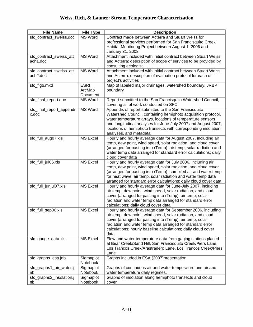
File Name File Type Description sfc_contract_sweiss.doc MS Word Contract made between Acterra and Stuart Weiss for
professional services performed for San Francisquito Creek Habitat Monitoring Project between August 1, 2006 and January 31, 2008
sfc_contract_sweiss_attach1.doc
MS Word Attachment included with initial contract between Stuart Weiss and Acterra: description of scope of services to be provided by consulting ecologist
sfc_contract_sweiss_attach2.doc
MS Word Attachment included with initial contract between Stuart Weiss and Acterra: description of evaluation protocol for each of project's activities
sfc_fig6.mxd ESRI ArcMap Document
Map of labeled major drainages, watershed boundary, JRBP boundary
sfc_final_report.doc MS Word Report submitted to the San Francisquito Watershed Council, covering all of work conducted on SFC
sfc_final_report_appendix.doc
MS Word Appendix of report submitted to the San Francisquito Watershed Council, containing hemiphoto acquisition protocol, water temperature arrays, locations of temperature sensors and longitudinal analyses for June-July 2007 and August 2007, locations of hemiphoto transects with corresponding insolation analyses, and metadata.
sfc_full_aug07.xls MS Excel Hourly and hourly average data for August 2007, including air temp, dew point, wind speed, solar radiation, and cloud cover (arranged for pasting into rTemp); air temp, solar radiation and water temp data arranged for standard error calculations; daily cloud cover data
sfc_full_jul06.xls MS Excel Hourly and hourly average data for July 2006, including air temp, dew point, wind speed, solar radiation, and cloud cover (arranged for pasting into rTemp); compiled air and water temp for heat wave; air temp, solar radiation and water temp data arranged for standard error calculations; daily cloud cover data
sfc_full_junjul07.xls MS Excel Hourly and hourly average data for June-July 2007, including air temp, dew point, wind speed, solar radiation, and cloud cover (arranged for pasting into rTemp); air temp, solar radiation and water temp data arranged for standard error calculations; daily cloud cover data
sfc_full_sep06.xls MS Excel Hourly and hourly average data for September 2006, including air temp, dew point, wind speed, solar radiation, and cloud cover (arranged for pasting into rTemp); air temp, solar radiation and water temp data arranged for standard error calculations; hourly baseline calculations; daily cloud cover data
sfc_gauge_data.xls MS Excel Flow and water temperature data from gaging stations placed at Bear Creek/Sand Hill, San Francisquito Creek/Piers Lane, Los Trancos Creek/Arastradero Lane, Los Trancos Creek/Piers Lane
sfc_graphs_esa.jnb Sigmaplot Notebook
Graphs included in ESA (2007)presentation
sfc_graphs1_air_water.jnb
Sigmaplot Notebook
Graphs of continuous air and water temperature and air and water temperature daily regimes,
sfc_graphs2_insolation.jnb
Sigmaplot Notebook
Graphs of insolation along hemiphoto transects and cloud cover
A-31

Weiss, Rich, & Launer: Stream Temperature Characterization
File Name File Type Description sfc_graphs3_initial.jnb Sigmaplot
Notebook Graphs of tree removal, semivariograms, old versions of DM subsurface flow, conceptual model (rTemp), open vs. closed canopy temperature
sfc_graphs4_longitudinal.jnb
Sigmaplot Notebook
Graphs of mean, average minimum and average maximum water temperature for each sensor along the length of the stream
sfc_graphs5_misc.jnb Sigmaplot Notebook
Graphs of heat wave, depth, red-legged frog habitat, and subsurface flow,
sfc_hp_06.xls MS Excel HemiView analysis of “Dennis Martin 1” (October 2006, hemiphotos #003-044, missing 024), “Lunar Rocks 1” (October 2006, hemiphotos #045-086), and “Los Trancos 1” transects (October 2006, hemiphotos #087-097)
sfc_hp_bc.xls MS Excel HemiView analysis of “Bear Creek” transect (August 2007, hemiphotos #345-385)
sfc_hp_bc_analyzed_aug07
Folder Edited and analyzed hemispherical photographs (JPG images and HemiView Settings files) taken in August 2007 in Bear Creek (#345-385)
sfc_hp_bc_aug07 Folder Original hemispherical photographs taken in August 2007 in Bear Creek (#345-385)
sfc_hp_dm1_analyzed_oct06
Folder Edited and analyzed hemispherical photographs (JPG images and HemiView Settings files) taken in October 2006 in “Dennis Martin 1” reach (#003-044, missing 024)
sfc_hp_dm1_oct06 Folder Original hemispherical photographs taken in October 2006 in “Dennis Martin 1” reach (#003-044, missing 024)
sfc_hp_dm2.xls MS Excel HemiView analysis of “Dennis Martin 2” transect (August 2007, hemiphotos #306-332)
sfc_hp_dm2_analyzed_aug07
Folder Edited and analyzed hemispherical photographs (JPG images and HemiView Settings files) taken in August 2007 in “Dennis Martin 2” reach (#306-332)
sfc_hp_dm2_aug07 Folder Original hemispherical photographs taken in August 2007 in “Dennis Martin 2” reach (#306-332)
sfc_hp_insolation MS Excel Daily insolation along the length of each hemiphoto transect
sfc_hp_log MS Excel Log of photo number, position, and field notes for hemispherical photographs
sfc_hp_lr1_analyzed_oct06
Folder Edited and analyzed hemispherical photographs (JPG images and HemiView Settings files) taken in October 2006 in “Lunar Rocks 1” reach (#045-086); includes virtual tree removal
sfc_hp_lr1_oct06 Folder Original hemispherical photographs taken in October 2006 in “Lunar Rocks 1” reach (#045-086)
sfc_hp_lr2.xls MS Excel HemiView analysis of “Lunar Rocks 2” transect (August 2007, hemiphotos #387-414, missing 388, 390, 396)
sfc_hp_lr2_analyzed_aug07
Folder Edited and analyzed hemispherical photographs (JPG images and HemiView Settings files) taken in August 2007 in “Lunar Rocks 2” reach (#387-414; missing 388, 390, 396)
sfc_hp_lr2_aug07 Folder Original hemispherical photographs taken in August 2007 in “Lunar Rocks 2” reach (#387-414; missing 388, 390, 396)
sfc_hp_lt1_analyzed_oct06
Folder Edited and analyzed hemispherical photographs (JPG images and HemiView Settings files) taken in October 2006 in “Los Trancos 1” reach (#87-97)
sfc_hp_lt1_oct06 Folder Original hemispherical photographs taken in October 2006 in “Los Trancos 1” reach (#87-97)
A-32

Weiss, Rich, & Launer: Stream Temperature Characterization
File Name File Type Description sfc_hp_lt2_analyzed_sep07
Folder Edited and analyzed hemispherical photographs (JPG images and HemiView Settings files) taken in September 2007 in “Los Trancos 2” reach (#39-49) for purposes of tree removal analysis
sfc_hp_lt2_removal_final.xls
MS Excel HemiView analysis of “Los Trancos 2” transect (September 2007, hemiphotos #39-49) after virtual tree removal
sfc_hp_lt2_removal_raw.xls
MS Excel HemiView analysis of “Los Trancos 2” transect (September 2007, hemiphotos #39-49) before virtual tree removal
sfc_hp_lt2_sep07 Folder Original hemispherical photographs taken in September 2007 in “Los Trancos 2” reach (#39-49) for purposes of tree removal analysis
sfc_hp_no_tree_final MS Excel HemiView analysis of “Lunar Rocks 1” transect (October 2006, hemiphotos #045-086), after virtual tree removal
sfc_hp_ph.xls MS Excel HemiView analysis of “Pumphouse” transect (August 2007, hemiphotos #333-344)
sfc_hp_ph_analyzed_aug07
Folder Edited and analyzed hemispherical photographs (JPG images and HemiView Settings files) taken in August 2007 in “Pumphouse” reach (#333-344)
sfc_hp_ph_aug07 Folder Original hemispherical photographs taken in August 2007 in “Pumphouse” reach (#333-344)
sfc_hp_protocol.doc MS Word Protocol for hemispherical photography acquisition
sfc_hp_spatialanalysis.xls
MS Excel Semivariogram and solar insolation calculations for hemiphoto transects Dennis Martin (Oct 06) and Lunar Rocks (Oct 06)
sfc_longitudinal.xls MS Excel Longitudinal analysis of thermochron data: mean, average maximum, and average minimum temperatures for each temperature sensor, in order along the stream, for each time period.
sfc_phase1_report.doc MS Word Report submitted 27 July 2007 to the San Francisquito Watershed Council, covering Phase 1 of research
sfc_phase2_report.doc MS Word Report submitted 21 September 2007 to the San Francisquito Watershed Council, covering Phase 2 of research
sfc_presentation.ppt MS PowerPoint
Updated version of ESA (2007) presentation.
sfc_rtemp_aug07.jnb Sigmaplot Notebook
Various graphs of air temperature, solar radiation, and observed and predicted water temperature for August 2007
sfc_rtemp_jul06.jnb Sigmaplot Notebook
Various graphs of air temperature, solar radiation, and observed and predicted water temperature for July 2006
sfc_rtemp_junjul07.jnb Sigmaplot Notebook
Various graphs of air temperature, solar radiation, and observed and predicted water temperature for June-July 2007
sfc_rtemp_poster.jnb Sigmaplot Notebook
Graphs of air temperature, solar radiation, and observed and predicted water temperature, made for 2007 AGU poster
sfc_rtemp_sep06.jnb Sigmaplot Notebook
Various graphs of air temperature, solar radiation, and observed and predicted water temperature for September 2006
sfc_temp_aug07.jnb Sigmaplot Notebook
Arrays of continuous and hourly water temperature graphs for August 2007.
sfc_temp_aug07.xls MS Excel Thermochron log and hourly/average hourly water temperature data for August 2007
sfc_temp_aug07_comparison.jnb
Sigmaplot Notebook
Graphs of various thermochron data sets from August 2007, grouped together for comparison
sfc_temp_junjul07.jnb Sigmaplot Notebook
Arrays of continuous and hourly water temperature graphs for June-July 2007
sfc_temp_junjul07.xls MS Excel Thermochron log and hourly/average hourly water temperature data for June-July 2007
A-33

Weiss, Rich, & Launer: Stream Temperature Characterization
A-34
File Name File Type Description sfc_temp_junjul07_comparison.jnb
Sigmaplot Notebook
Graphs of various thermochron data sets from June-July 2007, grouped together for comparison
sfc_temp_sep06.jnb Sigmaplot Notebook
Arrays of continuous and hourly water temperature graphs for September 2006
sfc_temp_sep06.xls MS Excel Thermochron log and hourly/average hourly water temperature data for September 2006
sfc_temp_sep06_comparison.jnb
Sigmaplot Notebook
Graphs of various thermochron data sets from September 2006, grouped together for comparison
sff_2005_encouraged_proposal_24mar05.doc
MS Word Encouraged Proposal form submitted in 2005 to the San Francisco Foundation
sff_2005_intent_to_apply_24mar05.doc
MS Word Intent to Apply form submitted March 24, 2005 to the San Francisco Foundation
sff_bay_fund_announcement_07.pdf
Portable Document Format
Announcement by the San Francisco Foundation of the availability of Bay Fund Grants in 2007
sff_diversity_policy.pdf Portable Document Format
San Francisco Foundation's policy on diversity
sff_encouraged_proposal_guidelines_06.pdf
Portable Document Format
San Francisco Foundation guidelines for submission of an Encouraged Proposal in 2006
sff_final_report_form.doc MS Word San Francisco Foundation cover sheet and guidelines for submission of final report
sff_intent_to_apply_guidelines_07v_final.pdf
Portable Document Format
San Francisco Foundation guidelines for submission of an Intent to Apply in 2006
sff_intent_to_apply_staff_list.pdf
Portable Document Format
San Francisco Foundation contact list for submission of an Intent to Apply in 2006
sff_intent_to_apply_v0306.doc
MS Word 2007 Intent to Apply form for the San Francisco Foundation
sff_progress_report_form_05.doc
MS Word San Francisco Foundation cover sheet and guidelines for submission of progress report
sfwc_2005_stream_budget2.xls
MS Word Work plan and detailed budget for first year of SFWC tree canopy monitoring project
stream_prospectus.doc MS Word Prospectus describing stream habitat conservation and restoration
stream_prospectus.pdf Portable Document Format
Prospectus describing stream habitat conservation and restoration
usgs_sfcproject ArcGIS Directory
GIS layers of cities in the watershed area, DEM, DOQ (1993), DRG (100k), DRG (24k), Bear Gulch Creek, Corte Madera Creek, Los Trancos Creek, San Francisquito Creek, major drainages, all streams/drainages in the area, lakes, Bear Gulch watershed, Corte Madera watershed, Los Trancos watershed, San Francisquito Creek watershed, San Francisquito watershed, watershed defined by SCVWD, countyline, parks, schools, churches, golf courses, libraries, municipalities, major and minor roads