Embed Size (px)
Citation preview
draft
Weather-Responsive Traffic Management Concept of Operations
prepared for
Federal Highway Administration
prepared by
Cambridge Systematics, Inc. 4445 Willard Avenue, Suite 300 Chevy Chase, Maryland 20815
January 10, 2003

Weather-Responsive Traffic Management Concept of Operations
Cambridge Systematics, Inc. 1-1
1.0 Concept of Operations
The purpose of this paper is to provide a concise summary of a concept of operation and associated research needs pertaining to weather-responsive transportation management. The primary focus of this paper is on the needs and activities of freeway and arterial transportation managers, and how these needs change or differ during adverse weather. However, the concept of operations also involves transportation-related activities of oth-ers including public transportation managers, public safety personnel, highway mainte-nance personnel, and emergency response personnel.
This paper focuses on weather events that: 1) can be predicted with reasonable notice; and 2) have a serious impact on the mobility and safety of transportation system users, but do not involve catastrophic events requiring major evacuations. Events included are major snowstorms, ice and freezing rain, low-visibility events such as fog, high winds, and thunderstorms or tropical storms.
The scope and responsibilities of transportation managers include two general areas: 1) operation of the transportation system through actions such as signal control, ramp meter operation, and implementation of roadway closures and detours; and 2) information on transportation system conditions delivered through dynamic message signs (DMS), commercial media, 511, the Internet, and Highway Advisory Radio. The term “response” is used in this paper to describe the activities of transportation managers. Response includes:
• Proactive planning for the event based on weather forecasts and impact assessment;
• Activities undertaken in response to system conditions during the event; and
• Activities undertaken after the event to help restore the system to normal.
This paper is intended to develop a general concept of operation for transportation man-agers. The issues being addressed include:
1. How can transportation managers respond to weather-related events and provide information to both internal users and the public?
2. How can transportation managers best utilize their resources to respond to weather-related events?
3. What procedures and processes are needed by transportation managers to support weather-related activities?
Weather-Responsive Traffic Management Concept of Operations
1-2 Cambridge Systematics, Inc.
4. How should these procedures and processes be integrated with other transportation management activities?
5. What additional resources are needed by transportation managers to support weather-related activities?
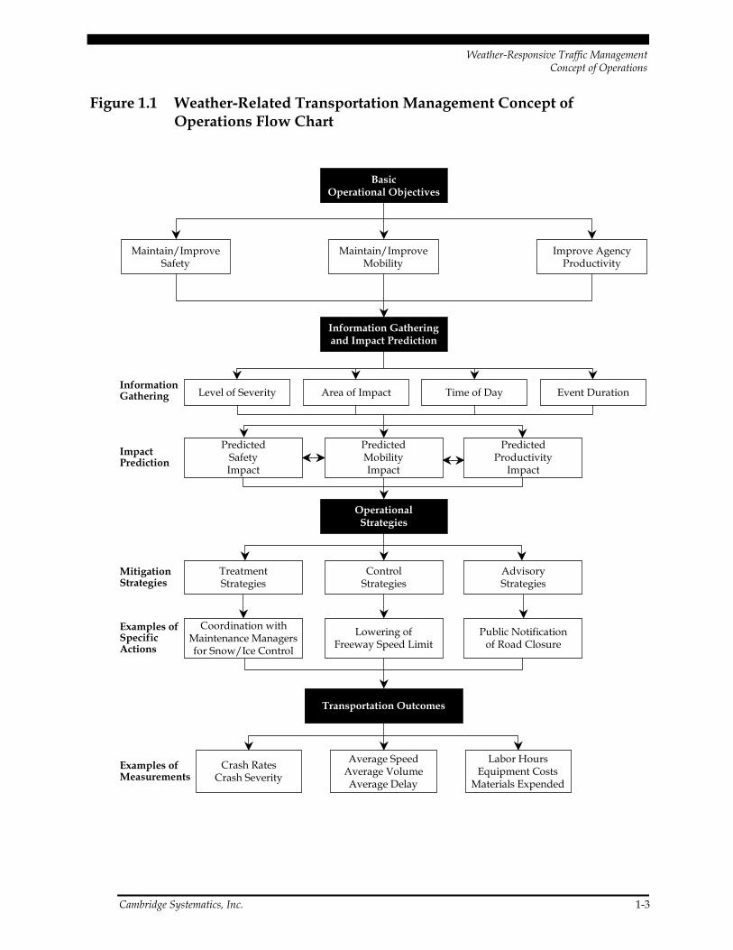
The flow chart provided in Figure 1.1 provides an overview of the transportation man-agement concept of operations as it relates to weather events. This paper will present sev-eral scenarios for the concept of operations. The proposed concept of operations follows the flow of activity as shown in the chart. The critical elements of this flow are:
1. Basic operational objectives – Transportation managers operate under a set of basic operational objectives, whether implicit or explicit. These objectives drive the activities and specific responses of the traffic management center (TMC) on a day-to-day basis. Three basic operational objectives have been identified to help guide the concept of operations: 1) improve safety; 2) improve mobility; and 3) improve agency productiv-ity. More specific objectives such as maintenance of traffic flow and rapid incident removal fall under these broad categories.
2. Information gathering and impact assessment – When weather occur or are predicted to occur, the traffic managers need to gather information on the event and assess its impacts. As transportation managers prepare for, or respond to, an event that may be very dynamic, they must understand its scope, severity, and impacts on the transpor-tation system. One of the important capabilities required to do this is predictive mod-eling. Response to weather-related events could be improved by the use of both historic and real-time data to predict traffic conditions over the period of the weather event. While both the data and the processing capabilities exist to do this, implemen-tation in most transportation management centers has been limited because of lack of resources.
3. Operational strategies – During a significant weather event, the traffic managers implement a series of specific operational strategies that are designed to meet the basic operational objectives identified above. Operational strategies consist of specific actions required to meet basic transportation objectives, and fall into three general categories: advisory, control, and treatment. Examples of specific operational strategies, or actions, that fall under these categories include public advisories through dynamic message signs, interactive telephone systems, and web sites; speed management in dangerous areas; and coordination with maintenance managers for snow and ice con-trol activities. New technologies can be applied to improve coordination between operations and maintenance personnel, improving the overall efficiency of the system. For example, operations personnel can operate automated deicing systems remotely, thus reducing labor requirements for maintenance personnel.
4. Transportation outcomes – Operational strategies are designed to achieve specific transportation outcomes that can be clearly identified and measured. These measures address the basic operational objectives by improving safety through crash reductions, improving traffic flow by decreasing weather-related delay, and improving agency productivity by minimizing operating and maintenance costs.
Weather-Responsive Traffic Management Concept of Operations
Cambridge Systematics, Inc. 1-3
Figure 1.1 Weather-Related Transportation Management Concept of Operations Flow Chart
Transportation Outcomes
Information Gatheringand Impact Prediction
Level of Severity Area of Impact Time of Day Event Duration
PredictedSafetyImpact
PredictedMobilityImpact
PredictedProductivity
Impact
OperationalStrategies
AdvisoryStrategies
TreatmentStrategies
ControlStrategies
BasicOperational Objectives
Maintain/ImproveSafety
Crash RatesCrash Severity
Labor HoursEquipment Costs
Materials Expended
Average SpeedAverage VolumeAverage Delay
Maintain/ImproveMobility
Improve AgencyProductivity
Public Notificationof Road Closure
Coordination withMaintenance Managersfor Snow/Ice Control
Lowering ofFreeway Speed Limit
InformationGathering
ImpactPrediction
MitigationStrategies
Examples ofSpecificActions
Examples ofMeasurements
Weather-Responsive Traffic Management Concept of Operations
1-4 Cambridge Systematics, Inc.
Each of these four elements is described below with a focus on the information required and the resources needed to successfully develop and implement the concept of opera-tions. There are elements, particularly those related to weather and traffic prediction, that will require additional research and development before they can be applied in the field.
1.1 Basic Operational Objectives
Transportation managers operate under a basic set of objectives that may be either explic-itly stated through mission statements or goals, or implied through the conduct of daily activities. “Basic” objectives drive the day-to-day activities of traffic managers and con-stitute their core mission. These objectives may vary from center to center but fall into three general categories that are listed below with some examples. It should be noted that many of the specific activities undertaken by traffic managers address more than one of these broad objectives:
Improve or Maintain Safety
• Use of traffic signal control systems, lane use signals, dynamic message signs, and other technologies to provide for safe operations and to clear roadways for emergency response vehicles and maintenance vehicles.
• Reduce the time required to detect, verify, and clear roadway incidents. These activi-ties benefit the safety of those involved in the incidents, the response crews, and the traveling public.
• Help to maintain safe speeds on the roadway. Speeds may be limited to protect work-ers on the roadway or to provide safer operating conditions in bad weather. Dynamic message signs and variable speed limit signs (VSLS) are among the tools that are used to accomplish this.
Improve or Maintain Mobility (or Traffic Flow)
• Help to maintain traffic flow by using detection and surveillance techniques to iden-tify congested areas and incidents, and allocate resources for quick removal of inci-dents from the roadway.
• Use coordinated arterial signal control plans and ramp meters to smooth the flow of traffic between freeways and arterials and help to optimize the network.
• Use information technologies, including advanced traveler information systems, to inform the public of adverse weather conditions on the transportation system, specific incidents, and heavy areas of congestion that may cause significant delays.

Weather-Responsive Traffic Management Concept of Operations
Cambridge Systematics, Inc. 1-5
Improve Productivity
• Use GPS-based technology for automated vehicle location to provide opportunities for more cost-effective use of snowplows and other maintenance vehicles during weather events.
• Use forecasts of severe weather to assist scheduling personnel in both transportation management centers and maintenance operations.
• Provide route-specific information to commercial vehicles in order to enhance safety and improve productivity.
In many cases, the transportation managers’ responses to weather events fit very well within the context of basic management objectives. In other cases, objectives may have to be modified to address the transportation system impacts of a weather event. These deci-sions will be based largely on the type and severity of the event.
1.2 Information Gathering and Impact Prediction
Information gathering and prediction of the impacts of weather events are important in the development and implementation of operational strategies and response plans. Information gathering capabilities related to both weather and traffic conditions are in place and improving rapidly. Improved predictive capabilities are critical to effective operations as described in this paper. One element includes tailored weather forecasts that enable transportation managers to identify weather impacts on specific facilities. The second element includes the application of models that predict short-term traffic flow impacts using historical data and real-time traffic information. The system performance data produced by traffic management centers on a day-to-day basis provides great poten-tial in this area, but the resources required to analyze the data and develop the necessary decision support tools have generally not been available.
The type of weather event that is occurring will influence decisions of traffic managers. Weather events can range from relatively localized phenomena (thunderstorms, fog, and tornadoes) to major events that may require evacuation over a wide area (hurricanes, floods). Specific weather may vary over different parts of a region (rain, ice, snow) resulting in a need for different responses. Transportation managers need the ability to gather and process information on the location, characteristics, and duration of weather events, as well as the ability to predict their impacts.
When responding to weather events, transportation managers have limited time and resources to make decisions and implement them. It is important that critical information be of high quality, be specific to the roadside conditions, and is delivered to the traffic management center in a format that is easily understood and acted upon. Weather infor-mation that is too technical and requires too much interpretation may be of limited use.
Weather-Responsive Traffic Management Concept of Operations
1-6 Cambridge Systematics, Inc.
Ideally, weather information should be integrated into the same software systems that transportation managers use to receive, process, and interpret traffic data.
Effective response requires that transportation managers be able to gather and process information on key characteristics of a weather event. Operational strategies should reflect the best understanding possible of such weather event characteristics including:
• Severity – Precipitation type and amount, temperature, visibility, and wind speed are among the specific measures that will describe the severity of the weather event. The degree of potential risk to life and property will vary greatly and influence the response.
• Area of Impact – The size and characteristics of the geographic area impacted by the event will have a major influence on operational strategies. Weather events may influence an area beyond the range of individual jurisdictions, requiring additional coordination activities. A common terminology and clear understanding of weather events and their impacts are needed to define the area of impact.
• Time of Day – The operational strategies implemented will vary based on time of day. Events occurring during peak hours will require different, and more complex, strate-gies than those required during periods of light travel. Events occurring during morning peak will require a different response than those occurring during evening peak.
• Lead Time – The lead time prior to the weather event will influence the response of the transportation managers. Transportation managers need an understanding of forecast accuracy and risk factors in order to deploy the appropriate level of resources.
• Event Duration – The anticipated duration of the weather event, as well as the start and stop times, will also influence operational strategies. Contingency plans must be part of the strategy in case the event is either longer or shorter than anticipated. Events starting just prior to or during peak periods will require different response plans than those events that start during periods of light travel.
Operational strategies should reflect the best available estimate of the impacts of the weather event. Both historical data and predictive tools can be helpful in identifying these impacts. Some of the specific impacts include:
• Safety Impact – Tools are also needed to estimate safety impacts of both weather events and response strategies. These tools would use historical data, traffic flow information and weather forecast data to determine what areas are most vulnerable to incidents. Response priorities, public information messages, deployment strategies for service patrols, lowered speed limits, and road closures/detours are among the strate-gies that may be evaluated and deployed as the result of a safety analysis.
• Mobility Impact – Weather can impact mobility and traffic flow by reducing pave-ment friction, obstructing travel lanes, reducing capacity, reducing speeds, increasing speed variability, and increasing delay. Tools to predict traffic flow conditions are
Weather-Responsive Traffic Management Concept of Operations
Cambridge Systematics, Inc. 1-7
important in helping to identify where and how weather events will impact travel conditions. This information can be used to modify speed limits, set priorities and policies for roadway clearance, and implement detour routes and other operational policies. Service patrols are another tool used by transportation managers to clear incidents more quickly, thus minimizing the impact on traffic flow. Predictive tools should incorporate both historical and real-time data.
• Maintenance/Operational (Productivity) Impact – Improved weather forecasts and improved techniques for predicting the impact of weather on roadways and trans-portation facilities are important to improve operating efficiency. Forecasts can help to efficiently schedule staff required to address a weather event. Improved communi-cations and coordination between transportation operations and management person-nel can stretch resources for both.
1.3 Operational Strategies
When a significant weather event occurs, transportation managers implement strategies in order to maintain safety and mobility. Strategies may be codified through formal or informal “response plans” or may be based on the experience of key personnel and operators. Implementation of operational strategies may require tradeoffs between competing objectives. An objective of smooth traffic flow, for example, might be sacrificed for purposes of safety and/or operating efficiency (priority movement of maintenance and emergency vehicles). Improved procedures for forecasting both weather and traffic impacts, combined with decision-support systems, will help transportation managers to more quickly approach the optimal balance among competing objectives.
Operational strategies can be divided into three categories:
• Advisory Strategies – These strategies provide information on weather and traffic to the public and transportation managers. Methods may include information dissemi-nation through dynamic message signs, Highway Advisory Radio, the Internet, and commercial media. The 511 call number for transportation information provides an excellent resource for disseminating weather-related transportation information because it will be standard across the United States. Both pre-trip and en-route sources of information are provided. In less severe weather events, advisories may give travelers advanced warning of adverse road weather and/or traffic conditions ahead. In more severe conditions, advisories may be used to discourage travel or pro-vide advance notice of closures on certain facilities.
• Control Strategies – These strategies alter the state of roadway devices to regulate traffic flow and roadway capacity during a weather event. Strategies include lowering of freeway speed limits through use of dynamic message signs or variable speed limit signs, modification of ramp metering rates or signal timing to slow the flow of traffic, and use of flashing beacons and Highway Advisory Radio to issue warnings. In some
Weather-Responsive Traffic Management Concept of Operations
1-8 Cambridge Systematics, Inc.
rural areas, traffic managers use gates in extreme conditions to close dangerous por-tions of roadway.
• Treatment Strategies – Treatment strategies include road maintenance resources sup-plied directly to roads to mitigate the impact of the weather event on transportation facilities. Many treatment strategies involve coordination of traffic, maintenance, and emergency management agencies. For the traffic management center, treatment strategies may involve supporting maintenance activities by clearing lanes for plowing or providing information on weather and roadway conditions obtained from surveil-lance cameras to field personnel.
Operational strategies are implemented through specific actions. These actions may address more than one strategy. Some examples are listed below:
• Access Control (control) – Transportation managers may take actions to clear specific facilities for safety, maintenance, and emergency response activities. Examples include road, bridge, and ramp closures; tire controls; lane use controls; and vehicle type restrictions. Both traveler information and physical actions (road closures, lane closures) may be used to accomplish this. Increased availability of electronic field equipment and information services improves the ability of transportation managers to implement these actions.
• Incident Management (control) – Incident management is documented to have a major impact on both the safety and the mobility of the transportation system. Rapid removal of incidents enhances safety by providing faster medical care to those who need it and preventing secondary crashes. Only a few minutes improvement in response time can have significant positive impacts on traffic flow. Freeway service patrols, sharing of center space with police, and good communications with public safety agencies and maintenance personnel all contribute to effective incident man-agement. Pre-planned responses that address closures/detours and public messages are also helpful in improving incident response times.
• Demand Management (control, advisory) – Under certain weather-related conditions, it may be essential to reduce the overall volume of traffic on specific facilities or on the entire system. Demand management strategies used are now primarily advisory in nature. Advisories are issued to the public asking that travelers either stay where they are or use alternate modes until conditions improve. Under extreme conditions, how-ever, more proactive strategies may be implemented. Restrictions implemented on single-occupancy vehicles in lower Manhattan in the post September 11th period are an example. Advances in technology and expansion of ITS systems may eventually per-mit similar strategies to be used in severe weather conditions.
• Public Advisories (advisory) – Transportation managers use a variety of techniques to warn travelers of adverse conditions, and in some cases, request that non-essential travel be avoided. Traffic managers directly control dynamic message signs, Highway Advisory Radio, and web sites. 511 interactive telephone services are coming into operation around the United States and will play an increasingly important role in
Weather-Responsive Traffic Management Concept of Operations
Cambridge Systematics, Inc. 1-9
disseminating traveler information. Information is also provided to commercial media for dissemination. An emerging area of interest is in-vehicle technology, which could also serve to disseminate specifically targeted information on adverse travel conditions.
• Speed Management (control, treatment) – Speed reduction may also be necessary for the safety of maintenance/operations personnel and the general public. Variable speed limits are currently in use on some facilities for this purpose. Speed manage-ment strategies require determination of safe travel speeds under prevailing conditions.
• System Maintenance and Preservation (treatment) – This strategy deals directly with the impact of weather on the roadway or on other transportation infrastructure, and is often undertaken by maintenance personnel. Treatment strategies include debris removal, snow and ice removal, and fog dispersion. This strategy also includes relo-cating devices or equipment to prevent damage by weather events.
In order to effectively implement operational strategies, it is important to identify key agencies and personnel and methods of communication. Specific protocols and messages may be required to assure clear understanding of events and responsibilities.
The operational concept requires the deployment of resources to carry out strategies and meet operational objectives. Critical resources include:
• Operations personnel including transportation managers and technicians, traffic operators, police dispatch personnel, maintenance dispatch personnel, and weather specialists.
• Field personnel include maintenance workers, snowplow operators, law enforcement personnel, service patrol operators, and first responders.
• Processing capabilities are needed to forecast the impacts of weather events on the transportation systems. Most development efforts focus on traffic flow models, but estimates of incidents and safety factors could be developed as well.
• Information services (both private and public) for dissemination of weather and traffic information to managers and the public on weather-related roadway conditions, and actions being taken to address the situation.
• Field devices including dynamic message signs, variable speed limit signs, lane use signals, special warning systems, signal systems, and Highway Advisory Radio systems.
Specific scenarios are proposed in this paper to initiate discussion on how a comprehen-sive approach can help to improve transportation operations and safety during weather events. This approach will also help to identify “gaps” that need to be filled through new approaches, new products, or additional research. An important objective is to identify what is currently being done, what can be done, and how best to implement desired
Weather-Responsive Traffic Management Concept of Operations
1-10 Cambridge Systematics, Inc.
practices. The approach of this paper presents the state-of-the-art, or what could be achieved using existing technologies. The existing state-of-the-practice generally does not yet follow this concept, due primarily to resource limitations.
1.4 Transportation Outcomes
Finally, the effectiveness of operational strategies should be measured in order to determine:
• Whether the strategies met their objectives;
• How strategies can be changed to better meet operational objectives;
• Whether the objectives are realistic, or should be modified; and
• Additional resources and tools that are needed in order to meet the objectives.
The ability of transportation managers to archive information on traffic volumes, speeds, incidents, and responses has been steadily improving. FHWA’s Mobility Monitoring pro-gram has demonstrated how archived information from traffic management centers can be used to measure metropolitan area congestion in a variety of different ways. This information has great potential for local use in evaluating and improving operational strategies and then calculating the benefits of this activity. However, the resources required to realize the benefits from this information have not been available to most traf-fic managers.
Weather-Responsive Traffic Management Concept of Operations
Cambridge Systematics, Inc. 2-1
2.0 Weather Scenarios
A series of scenarios are presented in this section to demonstrate the concept of operations under adverse weather conditions. These scenarios focus on the activities of freeway traf-fic managers, but involve other transportation managers as well. The following sections include background on the scenarios and a set of basic assumptions related to traffic man-agement capabilities available. These assumptions remain constant through the weather scenarios that are presented.
2.1 Weather-Responsive Traffic Management
Regardless of the local climate, all traffic managers will need to address the challenges created by adverse weather conditions. The concept of operations for weather-related events should be based on the operational objectives and strategies of the traffic manage-ment center. While specific response plans must be defined in order to maximize safety and respond effectively to weather events, these plans should reflect the overall priorities and objectives of the traffic management center.
The type and severity of weather events varies widely by region. Moreover, not all loca-tions with similar weather conditions have the same capability to collect and process data on weather conditions and the impact of weather events on traffic. Incident response capabilities will also vary between different metropolitan areas. Cities in warmer regions that receive an occasional ice storm or snowstorm will have fewer maintenance vehicles and trained personnel available than cities in colder climates. Therefore, their response plans may emphasize a different mix of operational strategies; for example, demand man-agement may be emphasized over freeway/traffic management. Traffic management centers need to develop appropriate response policies and procedures that align with their available resources. This process will also help agencies to set funding priorities by identi-fying the missing resources that are most needed.
Weather-Responsive Traffic Management Concept of Operations
2-2 Cambridge Systematics, Inc.
2.2 Definition of Weather Scenario
The weather scenario is defined through the information gathering process. This process will focus initially on the characteristics of the predicted event, including:
• Event type;
• Geographic area impacted;
• Lead time to event;
• Characteristics of event (forecasted possible range of accumulation, wind speed, visibility, etc.);
• Projected start time;
• Projected stop time;
• Minimum/maximum duration times; and
• Concurrent weather.
One of the resources that would be helpful to traffic management centers is the ability to estimate the impact of this weather scenario on:
• Traffic flow/mobility;
• Safety; and
• Productivity, measured primarily by agency operating costs.
There are ongoing efforts in the road maintenance area to improve forecasts of weather impacts on specific transportation facilities. However, traffic managers generally do not have the capability to quantitatively estimate the impact of weather on roadway capacity and crash rates. The large amount of historical data generated by most traffic manage-ment centers provides good opportunity to estimate these impacts.
2.3 Operational Strategies
The next step is to identify operational strategies to counter the impacts of the weather event on traffic flow, safety, and productivity. Major categories of operational strategies include those related to treatment, traffic control, and information advisories. The focus of the TMC is on the latter two, control and advisory strategies. Some of the specific actions that traffic managers may either implement or support include:

Weather-Responsive Traffic Management Concept of Operations
Cambridge Systematics, Inc. 2-3
• Access Control;
• Incident Management;
• Demand Management;
• Public Advisories;
• Lane Use Control;
• Speed Management; and
• System Maintenance and Preservation.
Interagency coordination and communication represent a critical element that overlays all of the strategies identified above. A close working relationship between transportation operations and maintenance personnel, and between transportation and public safety agencies, will greatly improve response to weather-related events. Regular meetings for review and development of response plans, effective radio communication, and linkages between agency computer systems are some of the products of interagency coordination that enhance response capabilities.
Once these specific actions have been selected and prioritized, more detailed operational plans can be finalized and implemented. These plans assign responsibilities for action, identify coordination requirements, specify informational or advisory messages, and identify additional resource requirements. Specific, desired outcomes should also be identified.
Finally, a record of events and all actions taken in response to the weather events should be documented as they occur. These reports can be used to track progress and measure performance. Appropriate measures of effectiveness should be identified as well.
2.4 Weather Scenario Assumptions
A set of common assumptions regarding transportation system and operational capabili-ties are applied to all scenarios. While the regional freeway traffic management system is the focus of these assumptions, other transportation managers, as well as public safety and emergency response agencies, are included. The assumptions are listed below:
• Area experiences high levels of congestion on freeway and arterial systems.
• A traffic management center covers the entire freeway system and is collocated with state police. The TMC does not have jurisdiction or coverage on major arterials.
• The freeway management system has full detection capabilities, closed-circuit televi-sion (CCTV) surveillance coverage is not 100 percent but it is available on the most heavily traveled freeway sections, and dynamic message signs are in place at most major decision points.
Weather-Responsive Traffic Management Concept of Operations
2-4 Cambridge Systematics, Inc.
• Ramp metering system is in place on freeways in most heavily traveled portions of region.
• The TMC is able to provide a limited number of CCTV camera images to the main DOT maintenance center in the region.
• The TMC has limited capability to share computer images with arterial signal control centers and with the regional transit authority. There are “hot lines” between these agencies for communications in emergencies.
• The TMC has a web site that can display route-specific information on freeways only. Roadway condition information can be displayed on a map. A limited number of camera feeds are available to television stations that have signed up for the service.
• Arterial alternate routes are available for most major freeways except for several major bridge crossings.
• Arterial signal control is under multiple jurisdictions. Some corridors have advanced signal control while others do not.
Major operational objectives of the traffic management center include the three basic objectives of improving safety, mobility, and productivity. Specific objectives include maintaining traffic flow and avoiding bottlenecks on the regional bridge crossings, as well as the routes from those crossings to the major medical complex in the region. These crossings serve as key routes for emergency vehicles and backups have major impacts for traffic flow on other facilities near the bridge crossings. In addition, the bridge crossings and several of the approach roads are subject to icing when temperatures near freezing in wet conditions. Environmental Sensor Stations (ESS) are located on the bridges but are otherwise very limited in number.
Weather-Responsive Traffic Management Concept of Operations
Cambridge Systematics, Inc. 3-1
3.0 Weather Scenario Examples
3.1 Weather Scenario #1
The following scenario highlights the mitigation strategies that could be used to improve the safety and efficiency of the transportation system. Scenario #1 involves an occurrence of ice and/or freezing rain in a metropolitan area with a moderate climate such as St. Louis, Missouri; Washington, D.C.; Philadelphia, Pennsylvania; or New York, New York.
3.1.1 Description of Weather Event
A significant winter storm will produce widespread freezing rain across the metropolitan area. Depending on the track of its associated low-pressure system, portions of the area may see the freezing rain occasionally mix with or change to rain or snow. However, freezing rain will be the predominant threat with ice accumulations ranging from a tenth to a quarter of an inch. The event is expected to last from three to six hours beginning at 5:00 a.m., just before the Monday morning rush.
The occurrence of freezing rain is relatively rare for this metropolitan area. A thin coating of ice can be expected once every couple of years with a major ice storm about every five years.
Ice and/or freezing rain are forecast to occur across the entire metropolitan area. Accu-mulation is expected to range from a minimum of 0.25 inches to a maximum of 0.5 inches. The storm duration is projected to range between three and six hours, beginning at 5:00 a.m. on Monday. Meteorologists have reported that depending on the storm path, snow or rain is possible in some parts of the metropolitan area. Freezing precipitation occurs only occasionally in this area and this type of event will stretch available public safety and maintenance personnel. Safety concerns are judged to be a very high priority.
Weather-Responsive Traffic Management Concept of Operations
3-2 Cambridge Systematics, Inc.
3.1.2 Weather Impacts
Traffic managers use National Weather Service (NWS) forecasts and Environmental Sensor Station (ESS) observations to obtain information on weather threats and predict roadway impacts. The storm is anticipated to significantly impact traffic flow, safety and the productivity of transportation, public safety, emergency management and mainte-nance management and public works agencies in the area. Because freezing precipitation occurs only occasionally in this area, this type of event will stretch available public safety and maintenance personnel. Safety concerns are judged to be a very high priority. It is anticipated that the forecasted event will have the following impacts on the transportation system:
• Reduction in pavement friction impacting vehicle performance, including traction and maneuverability, pavement friction resulting in loss of control and skidding;
• Reduction in roadway capacity because of slower speeds, particularly on grades and horizontal and vertical curves, and at intersections;
• Reduction in visibility because of precipitation and windshield obstruction;
• Overall significant reduction in travel speed with greater speed variability resulting from differing driving tendencies and differences in vehicle ability to handle adverse weather;
• Periodic lane obstruction because of ice accumulation, closures for roadway treatment; and
• Disruption to public transportation schedules because of roadway conditions and likelihood of additional riders.
From similar circumstances in the past, it can be assumed that freeway and arterial capac-ity will be greatly reduced and that tree damage to the power supply infrastructure will cause traffic control device failures. Signal outages because of power failure are possible. Freeway capacity reductions are anticipated in this storm. Because of lowered speeds and possible lane closures for clearance, capacity reductions of 25 percent in off-peak to 50 percent in the peak are anticipated. Past experience has shown that some travelers will stay home, some will switch to transit, and others will shift to arterials because they feel more comfortable with the lower speeds. These shifts, however, will not compensate for the loss of capacity; therefore severe congestion is anticipated.
The expected safety impact will likely appear in the form of additional personal injury accidents and property damage crashes. Multi-vehicle accidents are of great concern and provide strong incentive for lowered speed limits or urging drivers to stay home.
Past experience has shown that a significant number of additional property damage acci-dents may occur during the peak period during this type of weather event and that 10 percent to 20 percent of these will involve injuries.
Weather-Responsive Traffic Management Concept of Operations
Cambridge Systematics, Inc. 3-3
It is also anticipated that additional costs will be incurred in terms of overtime for TMC transportation management and maintenance personnel. Transportation managers will call in additional operators to provide additional surveillance capabilities and improved interagency coordination. Additional funds will also be needed to pay contract resources for road treatment.
3.1.3 Operational Strategies
Mitigation strategies will focus on reducing the level of traffic on the roadways, limiting the speed of traffic, providing public advisories, including advanced warning of danger-ous conditions, and institutional coordination with emergency and maintenance manag-ers. Appropriate actions must be taken to mitigate the impact of weather scenarios. The TMC will call in additional operators to provide additional surveillance and extra help in making the required interagency contacts. It is anticipated that the RWIS equipment on the bridges, combined with the additional surveillance capability, will help assure that maintenance support and emergency medical support are available when needed. In this scenario, potential mitigation strategies have been identified under the major categories and are described below.
Advisory Strategies
• Issue public advisories via dynamic message signs to reinforce reduced freeway speed limit and to encourage safe following distance;
• Disseminate warnings via the Internet, commercial media, and interactive telephone system, and provide route-specific advisories over Internet and through commercial media; and
• Use commercial radio and dynamic message signs to discourage unnecessary traffic over bridge crossings.
Control Strategies
• Lower freeway speed limit;
• Adjust signal timing on parallel arterial corridors;
• Adjust ramp meter algorithms to minimize freeway congestion;
• Institutional coordination with law enforcement, including police presence at critical locations to enforce reduced speed limits and access controls;
Weather-Responsive Traffic Management Concept of Operations
3-4 Cambridge Systematics, Inc.
• Station emergency vehicles near critical locations to provide faster response to inci-dents; and
• Control access where necessary by closing roadways and detouring traffic.
Treatment Strategies
• Support access for emergency and maintenance vehicles to critical areas;
• Use RWIS data to identify how quickly ice will bond to road surfaces and what chemi-cals/abrasives can be used to improve the level of service; and
• General institutional coordination with maintenance managers for snow/ice control activities.
Cutting across the three strategies is the need to implement all available mechanisms to assure institutional coordination. In addition to the continuing coordination between state police and the DOT operators who share the TMC, additional communications links will be put in place to the for maintenance personnel, key arterial signal control centers in the region, and emergency medical services.
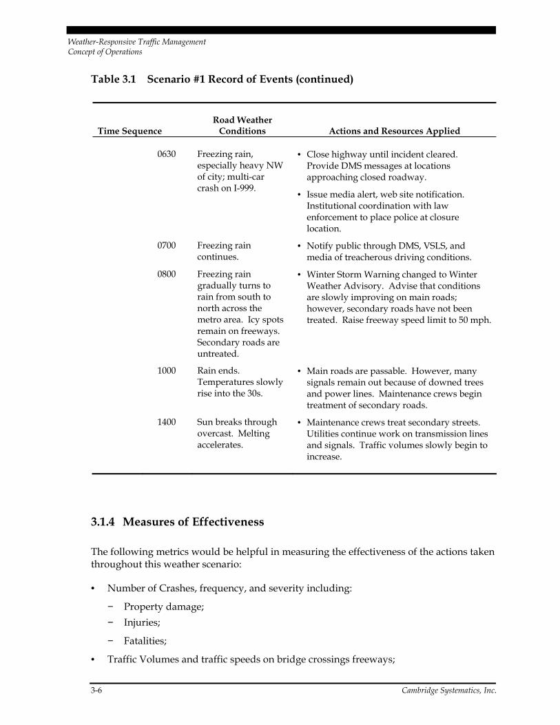
Weather Scenario #1 Record of Events
Table 3.1 contains the sequence of events throughout this weather scenario, including weather conditions, corresponding response actions taken, and resources used.

Weather-Responsive Traffic Management Concept of Operations
Cambridge Systematics, Inc. 3-5
Table 3.1 Scenario #1 Record of Events
Time Sequence Road Weather
Conditions Actions and Resources Applied
Sunday 1000 Cloudy. • NWS issues Winter Storm Watch for significant icing across the metro area. Conference calls made for institutional coordination with transportation managers in neighboring jurisdictions, maintenance managers, and emergency managers.
1800 Cloudy. Pavement temperature near freezing.
• Winter Storm Warning issued for entire metro area. Information gathering and impact prediction is taking place. Contact traffic management personnel for mobilization at 0200, prior to the onset of freezing precipitation.
Monday 0400 Light freezing rain begins across the entire metro area.
• Public notification; media and web site advisory; ask non-essential personnel to delay departure. Anticipated congestion.
• Display reduced limit (50 mph) on DMS and VSLS signs.
0430 Freezing rain begins to accumulate on pavement.
• Area schools close. First reports of crashes come in. All maintenance vehicles treat main roads.
0530 Moderate freezing rain and fog.
• Lift HOV restrictions; restrict high-profile vehicles to right lane.
• Notification of access restrictions through media alert, web site, and DMS.
• Additional service patrols in place.
0600 Freezing rain. • Scattered power outages cause traffic signal, DMS, and alternate lane signs to fail.
• Institutional coordination with emergency and maintenance managers, including stationing police, emergency vehicles, tow trucks, and other maintenance vehicles at critical locations.
Weather-Responsive Traffic Management Concept of Operations
3-6 Cambridge Systematics, Inc.
Table 3.1 Scenario #1 Record of Events (continued)
Time Sequence Road Weather
Conditions Actions and Resources Applied
0630 Freezing rain, especially heavy NW of city; multi-car crash on I-999.
• Close highway until incident cleared. Provide DMS messages at locations approaching closed roadway.
• Issue media alert, web site notification. Institutional coordination with law enforcement to place police at closure location.
0700 Freezing rain continues.
• Notify public through DMS, VSLS, and media of treacherous driving conditions.
0800 Freezing rain gradually turns to rain from south to north across the metro area. Icy spots remain on freeways. Secondary roads are untreated.
• Winter Storm Warning changed to Winter Weather Advisory. Advise that conditions are slowly improving on main roads; however, secondary roads have not been treated. Raise freeway speed limit to 50 mph.
1000 Rain ends. Temperatures slowly rise into the 30s.
• Main roads are passable. However, many signals remain out because of downed trees and power lines. Maintenance crews begin treatment of secondary roads.
1400 Sun breaks through overcast. Melting accelerates.
• Maintenance crews treat secondary streets. Utilities continue work on transmission lines and signals. Traffic volumes slowly begin to increase.
3.1.4 Measures of Effectiveness
The following metrics would be helpful in measuring the effectiveness of the actions taken throughout this weather scenario:
• Number of Crashes, frequency, and severity including:
− Property damage; − Injuries;
− Fatalities;
• Traffic Volumes and traffic speeds on bridge crossings freeways;
Weather-Responsive Traffic Management Concept of Operations
Cambridge Systematics, Inc. 3-7
• Traffic Volumes and traffic speeds on other major arterials facilities;
• Hours of delay; and
• Additional TMC operating and maintenance cost.
3.2 Weather Scenario #2
The following scenario highlights the mitigation strategies that could be used to improve the safety and efficiency of the transportation system. Scenario #2 involves an occurrence of a major snowstorm in a metropolitan area with a severe winter climate such as Minneapolis-St. Paul, Minnesota; Buffalo, New York; or Grand Rapids, Michigan.
3.2.1 Description of Weather Event
A major snowstorm is forecast across the metropolitan area with greater accumulations in the northern and western portions of the region. Accumulation is expected to range from a minimum of 14 inches to the south and east to a maximum of 22 inches to the north and west. The storm duration is projected to range between 18 and 24 hours, beginning around 3:00 p.m. on Tuesday afternoon. High winds with gusts up to 30 to 40 mph are anticipated during the early hours of the second half of the storm, resulting in blowing and drifting snow and significantly limited visibility.
Driving conditions will be particularly hazardous overnight because of the heavy snow and limited visibility. Because the accumulation of snow will take place over a long period of time, adequate resources should be available for clearance. However, safety concerns are judged to be a very high priority.
3.2.2 Weather Impacts
The storm is anticipated to significantly impact traffic, safety, and the productivity of transportation, public safety, and public works agencies in the area. Driving conditions will be particularly hazardous overnight because of the combination of heavy snow, gusty winds, and, at times, near zero visibility. Because the accumulation of snow will take place over a long period of time, adequate resources should be available for clearance. However, blowing and drifting could cause previously cleared roads to again become rapidly snow covered. Safety concerns are judged to be a very high priority. It is antici-pated that the forecast event will have the following impacts on the system:
• Very poor visibility on major highways – motorists will have difficulty locating lane markings, guide signs and freeway exits, particularly where drifting occurs;
• Loss of roadway capacity because of sudden slowdowns caused by reduced visibility;
Weather-Responsive Traffic Management Concept of Operations
3-8 Cambridge Systematics, Inc.
• Some loss of friction traction and skidding may be anticipated in some areas, although moisture content of snow will be relatively low;
• Loss of roadway capacity because of overall reduction in speed, greater speed variabil-ity will result from differing driving tendencies and differences in vehicle performance including traction, stability, and maneuverability, and ability to handle adverse weather;
• Periodic lane closures for roadway treatment;
• Lane obstruction from wind-blown debris on roadway from high winds blowing and drifting will also impact roads in open areas;
• Possible loss of power impacting traffic signals on major arterial corridors;
• Closure of some roadway segments using dynamic message signs and automatic gates; and
• Disruption to public transportation schedules because of roadway conditions and likelihood of additional riders.
From similar circumstances in the past, it can be assumed that freeway capacity will be reduced and signal outages because of power failures from gusty winds are possible. Freeway capacity reductions are anticipated in this storm. Because of drifting, lowered speeds, reduced visibility, and possible lane closures for snow removal, capacity reduc-tions of about 50 percent are anticipated. As winds diminish toward Wednesday morning, the end of the event, this situation will improve but roadway capacities will still be reduced. Past experience has shown that some travelers will stay home, some will switch to transit, and others will shift to arterials because they feel more comfortable with the lower speeds. These shifts, however, will not compensate for the loss of capacity; therefore severe congestion is anticipated. Roadway and wind conditions will be evalu-ated at 6:00 a.m. Wednesday to determine whether an advisory should be issued discour-aging non-essential travel.
The expected safety impact will likely appear in the form of additional personal injury accidents and property damage. Multi-vehicle accidents are of great concern in areas of high winds and drifting, and provide strong incentive for lowered speeds.
Past experience has shown that additional property damage accidents may occur during the peak period during this type of weather event. It is anticipated that 10 to 15 percent of these will involve injuries.
It is also anticipated that additional costs will be incurred in terms of overtime for TMC transportation management and maintenance personnel. Additional funds will also be needed to pay contract resources for road treatment. The TMC will call in additional operators to provide additional surveillance and extra help in making the required inter-agency contacts. It is anticipated that the RWIS equipment, combined with the additional
Weather-Responsive Traffic Management Concept of Operations
Cambridge Systematics, Inc. 3-9
surveillance capability, will help assure that maintenance support and emergency medical support are available when needed.
3.2.3 Operational Strategies
Mitigation strategies will focus initially on reducing the level of traffic on the roadways during the overnight hours. Depending on conditions Wednesday morning, additional advisories may be issued that discourage non-essential travel. At a minimum, mitigation will include limiting the speed of traffic, providing advanced warning of dangerous con-ditions, and providing access for emergency and maintenance vehicles. High priority will be given to keeping key interchanges and roadway segments open and operating. Advi-sory messages reinforcing lower speed limits and encouraging safe following distances will be placed on dynamic message signs. DMSs will also be used to provide advance warning of low-visibility areas or closed roadway segments. There are a limited number of variable speed limit signs that can also be used to help lower speeds.
The TMC will call in additional operators to provide additional surveillance and extra help in making the required interagency contacts. It is anticipated that the RWIS equip-ment, combined with the additional surveillance capability, will provide information needed to deploy maintenance support and emergency medical support where they are most needed.
Appropriate actions must be taken to mitigate the impact of weather scenarios. In this scenario, potential mitigation strategies have been identified under the three major catego-ries discussed in Section 1.0:
Advisory Strategies
• Use dynamic message signs to reinforce lower freeway speed limit and encourage safe following distance;
• Use dynamic message signs to provide warnings of closed freeway segments, to pro-vide information on detour routes, and to warn of lane closures for clearance;
• Disseminate warnings via the Internet, commercial media, or interactive telephone system;
• Provide route-specific advisories over Internet and through commercial media; and
• Use commercial radio and dynamic message signs to discourage unnecessary traffic.
Weather-Responsive Traffic Management Concept of Operations
3-10 Cambridge Systematics, Inc.
Control Strategies
• Lower freeway speed limit;
• Close key freeway segments with automatic gates where high winds and drifting reduce visibility to zero;
• Implement key preplanned detours in case of roadway closure;
• Adjust signal timing on parallel arterial corridors to relieve freeways;
• Adjust ramp meter algorithms to minimize freeway congestion;
• Lift HOV-lane restrictions; and
• Station emergency vehicles near critical locations to provide faster response to incidents.
Treatment Strategies
• Support access for emergency and maintenance vehicles to critical areas;
• Institutional coordination utilizing surveillance capabilities and communications with maintenance personnel to obtain early warning of areas with low visibility and drifting snow;
• Use RWIS data to identify locations for early treatment; and
• Station maintenance vehicles at critical locations to expedite treatment.
Cutting across the three strategies is the need to implement all available mechanisms to assure institutional coordination. In addition to the continuing coordination between state police and the DOT operators who share the TMC, additional communications links will be put in place to the for maintenance personnel, key arterial signal control centers in the region, and emergency medical services.
Weather Scenario #2 Record of Events
Table 3.2 contains the sequence of events throughout this weather scenario, including weather conditions, corresponding response actions taken, and resources used.

Weather-Responsive Traffic Management Concept of Operations
Cambridge Systematics, Inc. 3-11
Table 3.2 Scenario #2 Record of Events
Time Sequence Conditions Actions and Resources Applied
Monday 2100 Increasing clouds. Temperatures in the 30s.
• NWS issues a Winter Storm Warning for significant accumulating snow. Place conference call to all TMC managers. Begin staff planning.
Tuesday 0400 Cloudy. Temperatures near freezing.
• NWS issues a Blizzard Warning for one to two feet of snow with blowing/ drifting/winds of 30 to 40 mph.
1200 Cloudy. Scattered flurries.
• Provide advisory to media and web site of snow forecast during p.m. peak rush hour. Place advisory “Heavy snow forecast – plan accordingly” on DMS.
1500 Light snow begins. • Additional freeway patrols are put in place to prepare for peak period. Businesses begin early dismissal.
1600 Moderate snow. • Lower freeway speed limit to 50 mph using DMS and VSLS.
• Prohibit high-profile vehicles from left lane using DMS and media advisory.
1700 Heavy snow. • Provide additional media and Internet advisories. Encourage all who have reached home to stay in.
2000 Report from maintenance: visibility reduced to zero on two freeway segments. Winds increasing.
• Provide DMS and media warning of closure and specify detour route.
• Use automatic gate to close freeway segments.
• Send police patrols to gates to guide motorists off highway.
• Modify arterial signal timing along detour route.
Tuesday
Wednesday
Overnight Heavy snow. Gusty winds. Significant blowing and drifting.
• Lane closures put in place to expedite snow removal with DMS and police patrols used to clear lanes.
• Media and web advisories issued encouraging commuters to delay a.m. departure. Also provides notice of lower speed limit.
• Modify arterial signal timing to improve peak-period flow on major routes parallel to freeways.
Weather-Responsive Traffic Management Concept of Operations
3-12 Cambridge Systematics, Inc.
Table 3.2 Scenario #2 Record of Events (continued)
Time Sequence Conditions Actions and Resources Applied
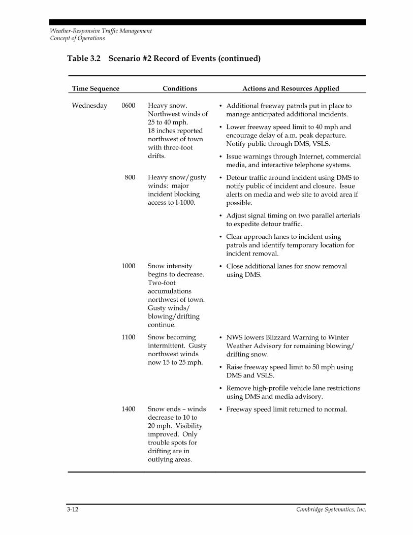
Wednesday 0600 Heavy snow. Northwest winds of 25 to 40 mph. 18 inches reported northwest of town with three-foot drifts.
• Additional freeway patrols put in place to manage anticipated additional incidents.
• Lower freeway speed limit to 40 mph and encourage delay of a.m. peak departure. Notify public through DMS, VSLS.
• Issue warnings through Internet, commercial media, and interactive telephone systems.
800 Heavy snow/gusty winds: major incident blocking access to I-1000.
• Detour traffic around incident using DMS to notify public of incident and closure. Issue alerts on media and web site to avoid area if possible.
• Adjust signal timing on two parallel arterials to expedite detour traffic.
• Clear approach lanes to incident using patrols and identify temporary location for incident removal.
1000 Snow intensity begins to decrease. Two-foot accumulations northwest of town. Gusty winds/ blowing/drifting continue.
• Close additional lanes for snow removal using DMS.
1100 Snow becoming intermittent. Gusty northwest winds now 15 to 25 mph.
• NWS lowers Blizzard Warning to Winter Weather Advisory for remaining blowing/ drifting snow.
• Raise freeway speed limit to 50 mph using DMS and VSLS.
• Remove high-profile vehicle lane restrictions using DMS and media advisory.
1400 Snow ends – winds decrease to 10 to 20 mph. Visibility improved. Only trouble spots for drifting are in outlying areas.
• Freeway speed limit returned to normal.
Weather-Responsive Traffic Management Concept of Operations
Cambridge Systematics, Inc. 3-13
3.2.4 Measures of Effectiveness
The following metrics would be helpful in measuring the effectiveness of the actions taken throughout this weather scenario:
• Crash frequency and severity including:
− Property damage; − Injuries; and
− Fatalities.
• Number of Accidents:
− Property damage; and − Injuries/Fatalities.
• Hours of Delay; and
• Additional TMC operating and maintenance cost.
3.3 Weather Scenario #3
The following scenario highlights the mitigation strategies that could be used to improve the safety and efficiency of the transportation system. Scenario #3 involves an occurrence of dense fog in a major metropolitan area with high levels of congestion and limited alter-native routes because of geographic constraints. The San Francisco-Oakland-San Jose region, New York – New Jersey, and Boston, Massachusetts, are examples of this type of region.
3.3.1 Description of Weather Event
A possibility of dense fog is projected along some of the major freeways in the area prior to and during the morning peak period. The fog may be accompanied by light drizzle that will further hinder visibility and create slippery conditions on roadways. Mitigation strategies will focus on pre-trip and en-route information warning of dangerous condi-tions. Depending on the severity of the fog condition, additional advisories may be issued that encourage travelers to avoid the area. At a minimum, mitigation will include advance warning of conditions, limiting the speed of traffic, and maintaining access for emergency and maintenance vehicles.

Weather-Responsive Traffic Management Concept of Operations
3-14 Cambridge Systematics, Inc.
3.3.2 Weather Impacts
The fog is anticipated to significantly impact traffic and safety on several of the area’s major freeways. It is anticipated that the event will have the following impacts on the system:
• Poor visibility on several major freeways with pockets of sudden, near-zero visibility regions, very dense fog appearing quickly, light drizzle may further impact visibility, motorists will have limited ability to see vehicles ahead;
• Loss of roadway capacity because of sudden slowdowns caused by reduced visibility;
• Some loss of friction and skidding because of road wetness from drizzle; may be anticipated if light rain or drizzle occurs;
• Loss of roadway capacity because of greatly reduced speeds and variability in visibil-ity, overall reduction in speed; and
• There is some concern about minor property damage accidents but major concern is potential for chain reaction accidents.
From similar circumstances in the past, it can be assumed that freeway capacity will be reduced by about 25 percent in impacted areas, with major slowdowns and congestion occurring in areas where visibility is very limited.
A slight increase in minor property damage accidents is anticipated. However, the great-est concern is about the possibility of multi-vehicle accidents. It is anticipated that existing TMC staff can handle this situation because it is forecast to be relatively short in duration. However, additional maintenance personnel, service patrols, and police presence are being called in so that a major incident can be quickly addressed.
3.3.3 Operational Strategies
Mitigation strategies will focus on pre-trip and en-route information warning of danger-ous conditions. Depending on the severity of the fog condition, additional advisories may be issued that encourage travelers to avoid the area. At a minimum mitigation will include advance warning of conditions and limits on the speed of traffic. Public advisory messages reinforcing lower speed limits and encouraging safe following distances will be placed on dynamic message signs. DMSs will also be used to provide advance warning of low-visibility areas. There is a limited number of variable speed limit signs s that can also be applied to lower speeds.
It is anticipated that existing transportation operations staff can handle this situation because it is forecast to be relatively short in duration. However, additional maintenance personnel, service patrols, and police presence are being called in so that a major incident can be quickly addressed.
Weather-Responsive Traffic Management Concept of Operations
Cambridge Systematics, Inc. 3-15
Appropriate actions must be taken to mitigate the impact of weather scenarios. In this scenario, potential mitigation strategies have been identified under the three major catego-ries discussed in Section 1.0:
Advisory Strategies
• Use dynamic message signs to encourage lower freeway speeds and encourage safe following distance;
• Disseminate warnings via the Internet, commercial media, or interactive telephone system;
• Provide route-specific advisories over Internet and through commercial media; and
• Use commercial radio and dynamic message signs to discourage unnecessary traffic.
Control Strategies
• Encourage lower freeway speeds;
• Implement key preplanned detours in case of major incident;
• Modify arterial signal timing on alternate routes in case of major incident;
• Adjust ramp meter algorithms to limit freeway access to areas experiencing dense fog;
• Lift HOV-lane restrictions; and
• Institutional coordination with maintenance and emergency management agencies including stationing additional maintenance vehicles, service patrols, and police pres-ence near impacted freeways to provide rapid incident response.
Treatment Strategies
• Institutional coordination with maintenance and police personnel utilizing communications to obtain early warning of areas with low visibility;
• Use RWIS data to identify locations with dense fog; and
• Encourage use of alternate routes.
Cutting across the three strategies is the need to implement all available mechanisms to assure institutional coordination. In addition to the continuing coordination between state police and the DOT operators who share the TMC, additional communications links will be put in place to the for maintenance personnel, key arterial signal control centers in the region, and emergency medical services.
Weather-Responsive Traffic Management Concept of Operations
3-16 Cambridge Systematics, Inc.
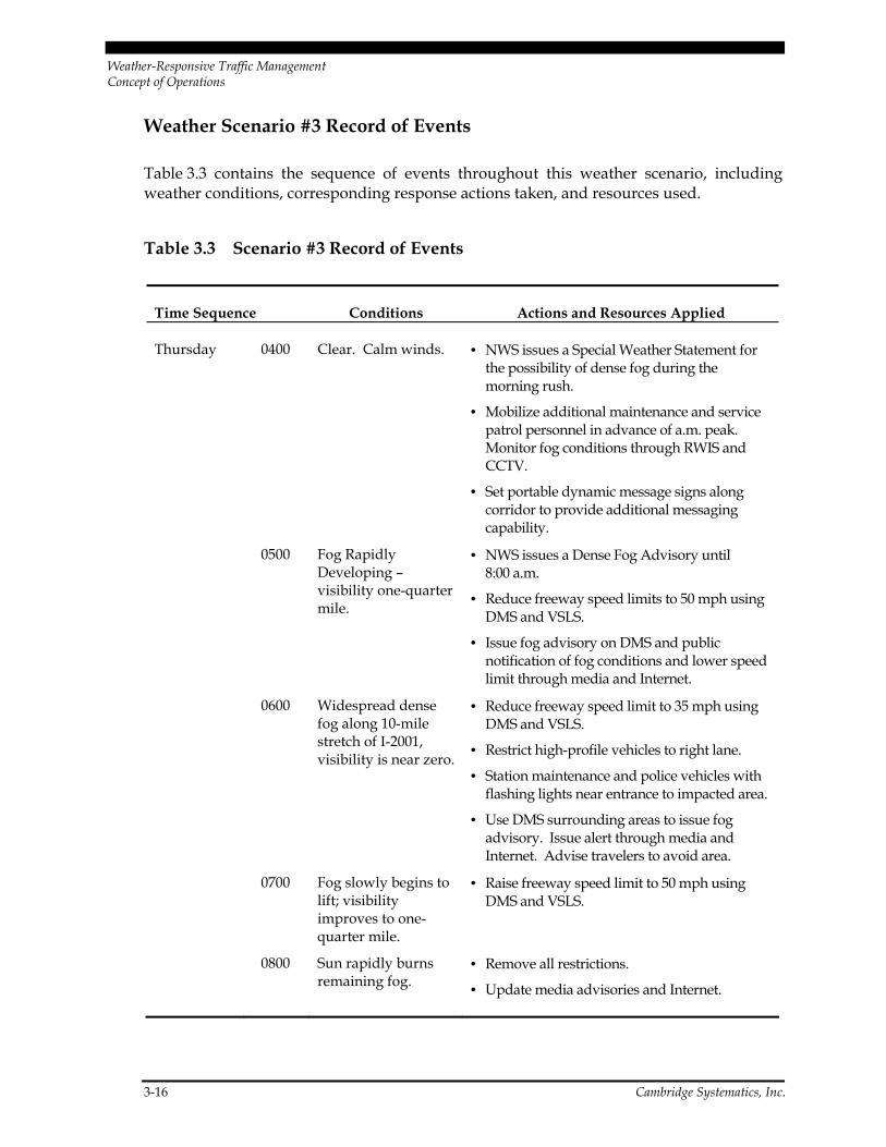
Weather Scenario #3 Record of Events
Table 3.3 contains the sequence of events throughout this weather scenario, including weather conditions, corresponding response actions taken, and resources used.
Table 3.3 Scenario #3 Record of Events
Time Sequence Conditions Actions and Resources Applied
Thursday 0400 Clear. Calm winds. • NWS issues a Special Weather Statement for the possibility of dense fog during the morning rush.
• Mobilize additional maintenance and service patrol personnel in advance of a.m. peak. Monitor fog conditions through RWIS and CCTV.
• Set portable dynamic message signs along corridor to provide additional messaging capability.
0500 Fog Rapidly Developing – visibility one-quarter mile.
• NWS issues a Dense Fog Advisory until 8:00 a.m.
• Reduce freeway speed limits to 50 mph using DMS and VSLS.
• Issue fog advisory on DMS and public notification of fog conditions and lower speed limit through media and Internet.
0600 Widespread dense fog along 10-mile stretch of I-2001, visibility is near zero.
• Reduce freeway speed limit to 35 mph using DMS and VSLS.
• Restrict high-profile vehicles to right lane.
• Station maintenance and police vehicles with flashing lights near entrance to impacted area.
• Use DMS surrounding areas to issue fog advisory. Issue alert through media and Internet. Advise travelers to avoid area.
0700 Fog slowly begins to lift; visibility improves to one-quarter mile.
• Raise freeway speed limit to 50 mph using DMS and VSLS.
0800 Sun rapidly burns remaining fog.
• Remove all restrictions.
• Update media advisories and Internet.

Weather-Responsive Traffic Management Concept of Operations
Cambridge Systematics, Inc. 3-17
3.3.4 Measures of Effectiveness
The following metrics would be helpful in measuring the effectiveness of the actions taken throughout this weather scenario:
• Number of Crashes, frequency, and severity:
− Property damage; − Injuries; and
− Fatalities.
• Volume of traffic volumes through impacted area; and
• Traffic speeds through impacted area during weather event.
3.4 Weather Scenario #4
The following scenario highlights the mitigation strategies that could be used to improve the safety and efficiency of the transportation system. Scenario #4 involves an occurrence of a major tropical storm in a large warm-weather, low-elevation metropolitan area such as Houston, Texas; Miami, Florida; Tampa-St. Petersburg, Florida; or New Orleans, Louisiana.
3.4.1 Description of Weather Event
A major tropical storm with anticipated flooding and some wind damage is forecast for the metropolitan area. Rainfall of up to one two inches an hour is anticipated in much of the region, with some areas receiving heavier rain for short periods of time during tropical squalls. Rain is forecast to start by mid-afternoon on Friday and will have a major impact on traffic in during the evening peak period. Tropical storm force high winds are antici-pated during later stages of the storm as the center approaches the coast, which could result in decreased visibility, wind damage, and power outages. Low-lying areas can anticipate flooding and certain roadways may be closed. Driving conditions will be impacted by heavy rain, flooding, and reduced visibility. Safety concerns are judged to be a very high priority.
3.4.2 Weather Impacts
The tropical storm is anticipated to significantly impact traffic, safety, and the productiv-ity of transportation, public safety, and public works agencies in the area. The rain and high winds will result in decreased visibility, some wind damage, and power outages. Areas prone to flooding can expect some roadway closures. Driving conditions will be
Weather-Responsive Traffic Management Concept of Operations
3-18 Cambridge Systematics, Inc.
impacted by torrential rain, greatly reduced visibility, and buffeting winds in squalls. Safety concerns are judged to be a very high priority. It is anticipated that the forecast event will have the following impacts on the transportation system:
• Very poor visibility on major highways – motorists will have difficulty locating lane markings, guide signs, and freeway exits during periods of heavy rain.
• Stalled vehicles and vehicles stopped on the shoulder will present additional hazards for moving traffic.
• Loss of roadway capacity because of high water and sudden slowdowns caused by reduced visibility. Capacity will also be reduced because of overall reduction in speed; greater speed differential; and differences in vehicle ability performance including traction, stability, and maneuverability.
• Loss of friction and skidding will occur in areas with high water.
• Debris on roadway from high winds including dangerous conditions from downed trees and/or power lines.
• Possible loss of power impacting traffic signals on major arterial corridors.
• Closure of flooded roadway segments using dynamic message signs and automatic gates.
• Possible need to provide detours and emergency services to support evacuation of flooded, low-lying areas.
• Disruption to public transportation schedules because of roadway conditions and likelihood of additional riders.
From similar circumstances in the past, it can be assumed that freeway capacity will be reduced and signal outages because of power failure are likely possible. Early in the storm, a capacity loss of about 20 to 25 percent is anticipated on the freeway system, because of reduced visibility and poor road conditions. As low-lying areas start to flood, several key stretches of freeway will probably need to be closed, resulting additional loss of capacity in the system. During the second half of the storm event, toward the end of the storm, high winds may result in additional capacity loss because of blown debris and downed trees and power lines. Past experience has shown that some many travelers will leave in advance of the storm because of overwhelming media coverage and others will shift to arterials because they feel more comfortable with the lower speeds. These shifts, however, will not compensate for the loss of capacity; therefore severe peak-period con-gestion is anticipated. Some evacuation from coastal and/or low-lying areas may be con-sidered in advance of the storm.
Weather-Responsive Traffic Management Concept of Operations
Cambridge Systematics, Inc. 3-19
The expected safety impact will likely appear in the form of additional personal injury accidents and property damage resulting from poor visibility and from wind buffeting on high-profile vehicles. Vehicles stalled in flooded areas present a major hazard to both the occupants of the vehicle and passing drivers.
It is also anticipated that additional costs will be incurred in terms of overtime for TMC and maintenance personnel, additional police presence, and service patrols. Maintenance personnel, police, and service patrols will be stationed near areas that traditionally flood first in a tropical storm and to assist in evacuations of vulnerable areas. Additional efforts will be made to keep key access/egress routes open for both emergency medical needs and evacuation. The TMC will call in additional operators to provide additional surveil-lance and extra help in making the required interagency contacts.
3.4.3 Operational Strategies
Mitigation strategies will focus initially on reducing the level of traffic on the roadways during the peak period. Priorities will also include placement of maintenance and service patrol vehicles for rapid response to stalled vehicles and other incidents, and rapid implementation of closures and detours in case of flooding. Advisory messages reinforcing lower speed limits and encouraging safe following distances will be placed on dynamic message signs. DMSs will also be used to provide advance warning of closed roadway segments. There are a limited number of variable speed limit signs that can also be used to help lower speeds. Additional efforts will be made to keep key access/egress routes open for both emergency medical needs and evacuation. Traffic managers will call in additional operators to provide additional surveillance and extra help in coordinating response efforts with those of other agencies.
Appropriate actions must be taken to mitigate the impact of weather scenarios. In this scenario, potential mitigation strategies have been identified under the major categories:
Advisory Strategies
• Use dynamic message signs to reinforce lower freeway speed limit and encourage safe following distance;
• Use media, Internet, and DMS to advise avoidance of flooded areas;
• Use dynamic message signs to provide warnings of closed freeway segments, to pro-vide information on detour routes, and to warn of lane closures for incident clearance;
• Disseminate warnings via the Internet, commercial media, or interactive telephone system, particularly to encourage avoidance of flooded areas;
Weather-Responsive Traffic Management Concept of Operations
3-20 Cambridge Systematics, Inc.
• Provide route-specific advisories over Internet and through commercial media; and
• Use commercial radio and dynamic message signs to discourage unnecessary traffic.
Control Strategies
• Lower freeway speed limit;
• Implement key preplanned detours in case of roadway closure;
• Support closure of flooded areas using media alerts, DMS, and police presence;
• Monitor key evacuation routes and use DMS signs to guide travelers;
• Modify signal timing on parallel arterial corridors to relieve freeway congestion resulting from closures;
• Close lanes to facilitate removal of incidents and stalled vehicles as well as removal of debris; and
• Remove HOV-lane restrictions.
Treatment Strategies
• Institutional coordination with maintenance and police personnel to expedite incident management and debris removal;
• Utilize surveillance capabilities and communications with maintenance personnel to obtain early warning of flooded areas;
• Use RWIS data to identify rainfall accumulation and peak gusts; and
• Station maintenance vehicles near areas most likely to flood.
Cutting across the three strategies is the need to implement all available mechanisms to assure institutional coordination. In addition to the continuing coordination between state police and the DOT operators who share the TMC, additional communications links will be put in place to the for maintenance personnel, key arterial signal control centers in the region, and emergency medical services.
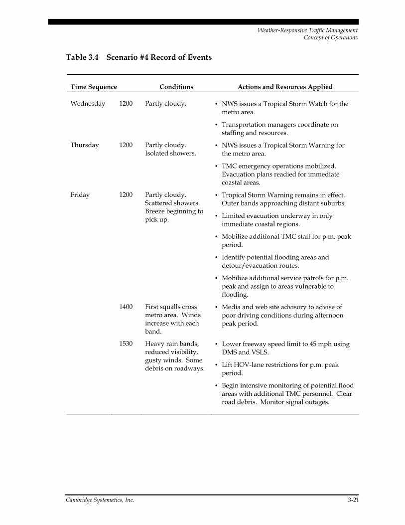
Weather Scenario #4 Record of Events
Table 3.4 contains the sequence of events throughout this weather scenario, including weather conditions, corresponding response actions taken, and resources used.
Weather-Responsive Traffic Management Concept of Operations
Cambridge Systematics, Inc. 3-21
Table 3.4 Scenario #4 Record of Events
Time Sequence Conditions Actions and Resources Applied
Wednesday 1200 Partly cloudy. • NWS issues a Tropical Storm Watch for the metro area.
• Transportation managers coordinate on staffing and resources.
Thursday 1200 Partly cloudy. Isolated showers.
• NWS issues a Tropical Storm Warning for the metro area.
• TMC emergency operations mobilized. Evacuation plans readied for immediate coastal areas.
Friday 1200 Partly cloudy. Scattered showers. Breeze beginning to pick up.
• Tropical Storm Warning remains in effect. Outer bands approaching distant suburbs.
• Limited evacuation underway in only immediate coastal regions.
• Mobilize additional TMC staff for p.m. peak period.
• Identify potential flooding areas and detour/evacuation routes.
• Mobilize additional service patrols for p.m. peak and assign to areas vulnerable to flooding.
1400 First squalls cross metro area. Winds increase with each band.
• Media and web site advisory to advise of poor driving conditions during afternoon peak period.
1530 Heavy rain bands, reduced visibility, gusty winds. Some debris on roadways.
• Lower freeway speed limit to 45 mph using DMS and VSLS.
• Lift HOV-lane restrictions for p.m. peak period.
• Begin intensive monitoring of potential flood areas with additional TMC personnel. Clear road debris. Monitor signal outages.
Weather-Responsive Traffic Management Concept of Operations
3-22 Cambridge Systematics, Inc.
Table 3.4 Scenario #4 Record of Events (continued)
Time Sequence Conditions Actions and Resources Applied
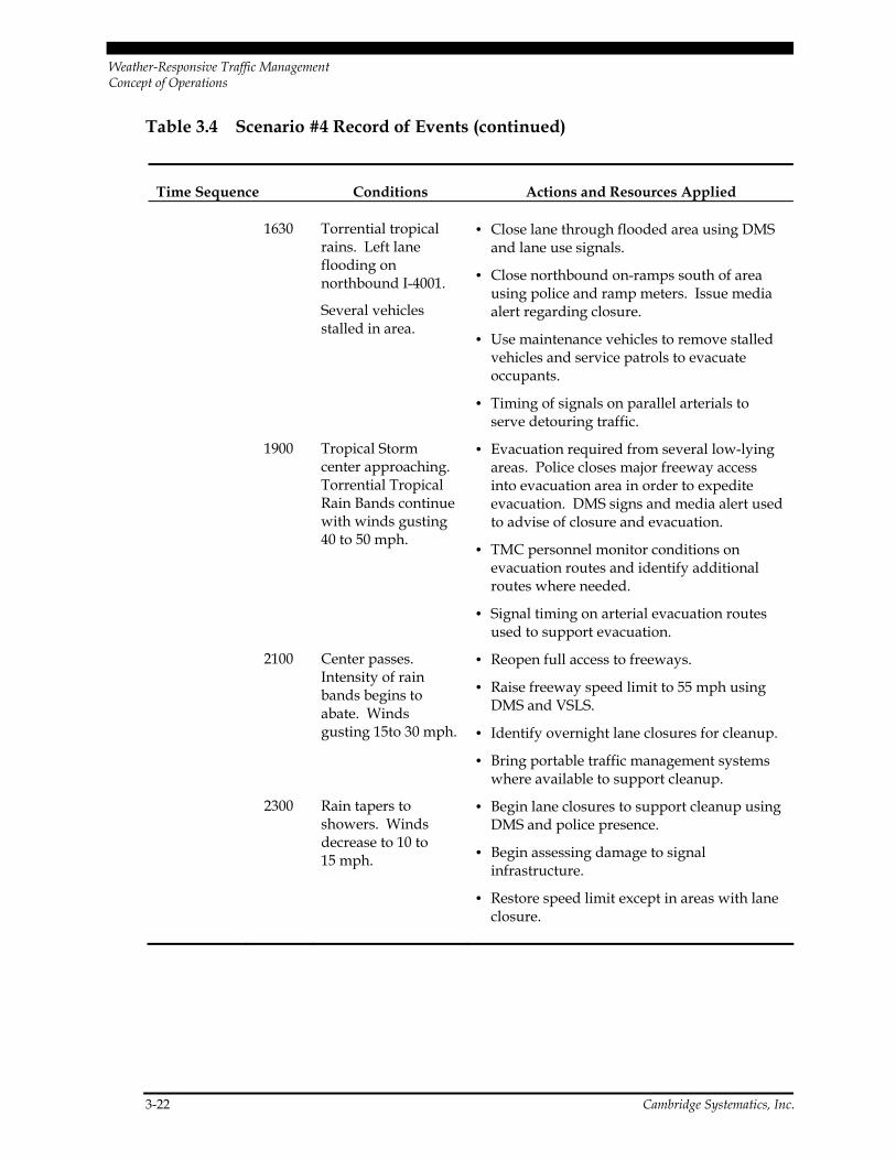
1630 Torrential tropical rains. Left lane flooding on northbound I-4001.
Several vehicles stalled in area.
• Close lane through flooded area using DMS and lane use signals.
• Close northbound on-ramps south of area using police and ramp meters. Issue media alert regarding closure.
• Use maintenance vehicles to remove stalled vehicles and service patrols to evacuate occupants.
• Timing of signals on parallel arterials to serve detouring traffic.
1900 Tropical Storm center approaching. Torrential Tropical Rain Bands continue with winds gusting 40 to 50 mph.
• Evacuation required from several low-lying areas. Police closes major freeway access into evacuation area in order to expedite evacuation. DMS signs and media alert used to advise of closure and evacuation.
• TMC personnel monitor conditions on evacuation routes and identify additional routes where needed.
• Signal timing on arterial evacuation routes used to support evacuation.
2100 Center passes. Intensity of rain bands begins to abate. Winds gusting 15to 30 mph.
• Reopen full access to freeways.
• Raise freeway speed limit to 55 mph using DMS and VSLS.
• Identify overnight lane closures for cleanup.
• Bring portable traffic management systems where available to support cleanup.
2300 Rain tapers to showers. Winds decrease to 10 to 15 mph.
• Begin lane closures to support cleanup using DMS and police presence.
• Begin assessing damage to signal infrastructure.
• Restore speed limit except in areas with lane closure.

Weather-Responsive Traffic Management Concept of Operations
Cambridge Systematics, Inc. 3-23
3.4.4 Measures of Effectiveness
The following metrics would be helpful in measuring the effectiveness of the actions taken throughout this weather scenario:
• Number of Crashes, frequency, and severity including:
− Property damage; − Injuries; and
− Fatalities.
• Number of stalled vehicles removed and time required;
• Time required for evacuation of flood-prone or coastal areas;
• Hours of delay; and
• Additional TMC operations and maintenance cost.
3.5 Weather Scenario #5
The following scenario highlights the mitigation strategies that could be used to improve the safety and efficiency of the transportation system. Scenario #5 involves an occurrence of thunderstorms in a major metropolitan area that experiences storms frequently during the summer and/or fall months. A large number of metropolitan areas throughout the United States experience this type of weather.
3.5.1 Description of Weather Event
After an extended stretch of very hot and humid weather, a cold front is forecast to cross the region during the Thursday afternoon rush hour. Along and ahead of the front, thun-derstorms are forecast to develop. The thunderstorms will be accompanied by high winds gusting up to 60 mph, lightning, and locally heavy rain. The storms will begin to affect the western suburbs around 3:00 p.m., clearing the region to the east during the early evening.
3.5.2 Weather Impacts
Torrential rainfall will produce greatly reduced visibility, the rapid ponding of water on roadways, and reduced traction. The gusty winds may produce some wind damage. Scattered power outages may impact arterial signal systems. Transportation managers and public safety personnel will need to plan for an increase in incidents throughout the region. It is anticipated that the forecast event will have the following impacts on the transportation system:
Weather-Responsive Traffic Management Concept of Operations
3-24 Cambridge Systematics, Inc.
• As motorists drive suddenly into heavy rain, braking and rapid speed reductions will create high potential for rear-end accidents. In areas that experience flooding, stalled and stopped vehicles will cause additional hazard.
• Motorists will pull off on the shoulder because of poor visibility, presenting additional hazards for moving traffic.
• Because of very poor visibility on major highways motorists will have difficulty locating lane markings, guide signs, and freeway exits during periods of heavy rain.
• Loss of friction and skidding will occur in areas with high water.
• Potential shift of some freeway traffic to arterials, where motorists are more comfort-able with slower speeds.
• Potential for debris on roadway from high winds including downed trees and/or power lines.
• Possible loss of power impacting traffic signals on major arterial corridors.
• Disruption to public transportation schedules because of roadway conditions, poor visibility, and heavy conditions, and likelihood of additional riders.
The expected safety impact will likely appear in the form of additional personal injury accidents and property damage resulting from poor visibility and from wind buffeting on high-profile vehicles. Vehicles stopped or traveling at very slow speed, as well as vehicles stalled in flooded areas, will present major hazards to both the occupants of the vehicle and passing drivers. It is also anticipated that additional costs will be incurred in terms of overtime for TMC and maintenance personnel, additional police presence, and service patrols.
3.5.3 Operational Strategies
While transportation managers will provide warnings of thunderstorms during peak hour, the frequency of these events makes it unlikely that many travelers will modify their schedules. As a result, transportation managers will focus their efforts on warnings to reduce speed and drive cautiously. Advisory messages reinforcing lower speeds and encouraging safe following distances will be placed on dynamic message signs. DMSs will also be used to provide advance warning of roadway incidents.
TMC operators will provide maintenance personnel with information on locations of debris on roadways and help service patrols identify stranded motorists. The TMC will call in additional operators to provide additional surveillance and extra help in making the required interagency contacts.
Appropriate actions must be taken to mitigate the impact of weather scenarios. In this scenario, potential mitigation strategies have been identified under the major categories:
Weather-Responsive Traffic Management Concept of Operations
Cambridge Systematics, Inc. 3-25
Advisory Strategies
• Use dynamic message signs to reinforce lower freeway speeds and encourage safe fol-lowing distance;
• Use media and Internet to provide warnings of severe weather impacts and potential flooding problems including route-specific advisories;
• Use dynamic message signs to provide warnings of flooded roadways and to provide advance warning of lane closures for incident clearance; and
• Use commercial radio and dynamic message signs to discourage unnecessary traffic.
Control Strategies
• Provide support for temporary closure of flooded areas where necessary, using media alerts, DMS, and police presence;
• Modify signal timing on parallel arterial corridors to accommodate additional traffic and provide relief to congested or flooded freeway segments; and
• Close lanes to facilitate removal of incidents and stalled vehicles as well as removal of debris.
Treatment Strategies
• Institutional coordination with maintenance and police personnel to expedite incident management and debris removal;
• Utilize surveillance capabilities and communications to support maintenance person-nel by obtaining early warning of incidents and flooded areas;
• Use RWIS data to identify rainfall accumulation and peak gusts; and
• Provide additional maintenance vehicles and service patrols to support rapid incident removal.
Cutting across the three strategies is the need to implement all available mechanisms to assure institutional coordination. In addition to the continuing coordination between state police and the DOT operators who share the TMC, additional communications links will be put in place to the for maintenance personnel, key arterial signal control centers in the region, and emergency medical services.
Weather-Responsive Traffic Management Concept of Operations
3-26 Cambridge Systematics, Inc.
Weather Scenario #5 Record of Events
Table 3.5 contains the sequence of events throughout this weather scenario, including weather conditions, corresponding response actions taken, and resources used.
Table 3.5 Scenario #5 Record of Events
Time Sequence Conditions Actions and Resources Applied
Thursday 1000 Mostly sunny. • NWS issues a hazardous weather potential statement highlighting the potential for thunderstorms during the afternoon and evening.
• Transportation managers note the potential.
1300 Partly cloudy. • NWS issues a thunderstorm watch for the metro area for late afternoon/early evening.
• Transportation managers coordinate on staffing and resources.
1500 Increasing clouds. Clouds begin to increase to the west.
• NWS issues a severe weather statement for the metro area. Thunderstorm development is imminent beginning in the west.
• Additional TMC operators called in. Additional service patrols and maintenance personnel mobilized for p.m. peak travel period.
1530 Lightning spotted to the west moving east.
• NWS issues first thunderstorm warning for the western counties in the metro area.
• Warning placed on DMS urging cautious driving.
• Media and web site advisory to advise of poor driving conditions during afternoon peak period.
1600 Thunderstorms reported in western suburbs. Wind gusts to 50 mph. Storms moving rapidly east.
• Thunderstorm warning remains in effect over western counties. New warnings issued for downtown region.
• Several DMS signs on westbound freeways warn of dangerous driving conditions ahead.

Weather-Responsive Traffic Management Concept of Operations
Cambridge Systematics, Inc. 3-27
Table 3.5 Scenario #5 Record of Events (continued)
Time Sequence Conditions Actions and Resources Applied
1630 Thunderstorms reported throughout the western suburbs and approaching downtown with widespread reduced visibility, gusty winds, torrential rains.
Multi-car incident reported on major north-south freeway I-5000.
• DMS messages used to encourage reduced speed – 40 mph – and drive cautiously.
• Monitor areas experiencing flooding.
• Use DMS to reroute traffic around major incident on I-5000. Adjust signal timing on parallel arterials.
1700 Thunderstorms move through downtown and approach eastern suburbs accompanied by torrential rains and high winds.
Because of poor visibility, many vehicles pulled off onto shoulder on I-6001. Stalled vehicles in area also.
• NWS issues thunderstorm warnings for eastern suburbs. Flash flood warnings are issued for downtown because of rapid ponding of water and rising creeks. Warnings expire in the western sections.
• Recommend deployment of additional maintenance and/or police vehicles to remove stalled vehicles and use flashing lights to protect vehicles on shoulder.
1730 Thunderstorms move over the eastern suburbs. Conditions improve over downtown.
Debris and ponding of water reported causing delays and dangerous conditions on I-5500.
• Thunderstorm warnings continue for the eastern suburbs. Flash flood statement issued for downtown as runoff continues from torrential rains.
• DMS signs used to warn traffic of debris and flooding in roadways.
• Maintenance crews notified of need to remove debris.

Weather-Responsive Traffic Management Concept of Operations
3-28 Cambridge Systematics, Inc.
Table 3.5 Scenario #5 Record of Events (continued)
Time Sequence Conditions Actions and Resources Applied
1800 Thunderstorms depart the eastern suburbs. Scattered reports of signal outages.
• All thunderstorm warnings discontinued for the metro area. Area creeks will remain high from runoff for several hours. Low-lying areas will take time to drain.
• Use web site, commercial media to warn public of areas with signal outages, debris in roadway, and freeways experiencing congestion.
3.5.4 Measures of Effectiveness
The following metrics would be helpful in measuring the effectiveness of the actions taken throughout this weather scenario:
• Number of Crashes, frequency, and severity including:
− Property damage; − Injuries; and
− Fatalities.
• Number of stalled vehicles removed and time required;
• Hours of delay; and
• Additional TMC operations and maintenance cost.
Weather-Responsive Traffic Management Concept of Operations
Cambridge Systematics, Inc. 4-1
4.0 Weather Information Research Needs
A concept of operations for weather-responsive traffic management appears to have great value for transportation managers. Advancement of this concept will be enhanced by:
• Establishment of mechanisms for improved coordination within transportation agency divisions and between transportation agencies and other key response agencies such as law enforcement, emergency management, and public works.
• Additional research that documents the best practices related to weather-responsive traffic management and quantifies their benefits.
4.1 Institutional Issues
Some of the issues that must be addressed to improve interagency coordination include:
• Co-location of activities within the traffic management center can improve the ability of transportation managers to coordinate their activities with other agencies. Many TMCs share space with state police. Providing a “seat” for personnel from DOT maintenance, emergency response agencies, and key local agencies can help to improve overall coordination during weather events. The availability of CCTV images throughout a region is a major “hook” to accomplish this.
• The role of transportation managers in new homeland security initiatives is still being defined but has important implications for response to other events such as weather. Homeland security will provide incentives for improved interagency cooperation and sharing of information and resources.
• In some areas of the country, additional agencies have been brought into the process of planning for weather emergencies. In many areas, however, transportation man-agement centers still not fully “at the table.” TMCs can bring both a knowledge of how the transportation system operates, as well as a significant amount of data that can be used to improve the effectiveness of winter maintenance and transportation operations. Traffic simulation capabilities, which reside in both transportation opera-tions and regional planning agencies, could be brought into the process to help evalu-ate response strategies and improve them.

Weather-Responsive Traffic Management Concept of Operations
4-2 Cambridge Systematics, Inc.
• Application of technical standards will also help to improve the effectiveness of weather-responsive traffic management. These standards, including those for com-munications equipment, protocols, and message content, will help to establish confi-dence in voice and data communications between agencies. Traffic managers, maintenance personnel, and emergency response personnel could all benefit from sharing the data available to them. The Regional ITS architecture process provides a good forum to identify these linkages and establish both the technical and institutional activities needed to make them a reality.
4.2 Research Needs
The control strategies described in this paper are being used, at least in part, by most traf-fic managers. The categorization of strategies into advisory, control, and treatment pro-vides a helpful framework for developing the concept of operations. However, additional research is needed to determine the effectiveness of current responses and to identify ways in which strategies can be enhanced and combined to meet performance objectives.
Capture of data from TMCs permits quantifiable measures of system effectiveness to be calculated and used in the development and refinement of operational strategies. FHWA has been sponsoring ongoing monitoring of traffic conditions in major metropolitan areas around the country. During the past year, data were collected from 17 TMCs by Texas Transportation Institute and Cambridge Systematics, Inc. and documented in the report, Monitoring Urban Roadways: Using Archived Data for Reliability and Mobility, submitted to FHWA Operations Core Business Unit, May 2001. Some of the indicators developed for this effort are listed below and could be applied over a period of time to assess the effec-tiveness of weather response strategies:
• Travel Time Index – A ratio of the peak-period to free-flow travel rate. A similar index could be developed for weather-related events.
• Delay Per Capita – This measure includes an estimate of the annual hours of delay (in hours) per person in the urban area. System data could be utilized to determine what portion of delay occurs during weather events.
• Percent Congested Travel – This is the percentage of travel occurring at less than 60 mph. Further breakdown of data in the future could permit an analysis of the causes of slower travel, including weather, construction, incidents, and volume-related congestion. This will vary significantly by region.
More complex measures that attempt to calculate the impact of system congestion on travelers and their behavior include:
• Buffer Index – The percentage of time above the average necessary to allow travelers to arrive on time for 95 percent of trips. The difference between the 95th and average travel rate divided by the average travel rate.
Weather-Responsive Traffic Management Concept of Operations
Cambridge Systematics, Inc. 4-3
• Misery Index – The length of delay for the most congested 20 percent of the trips. The average travel rate is subtracted from the average rate for the slowest 20 percent of the trips. That value is divided by the average. Therefore the Misery Index is a percent-age of extra time needed by the slowest 20 percent of trips.
• Percent Variation – The amount of extra time needed to be on time for 85 percent of the trips. This is calculated as the standard deviation divided by the average travel time.
System data could be used to further evaluate these measures and determine the impact of weather events on delays.
As system data is used to gain a better understanding of the impact of weather on the transportation system, other analytical techniques such as simulation models, can be used to estimate the benefits of different response strategies. This analysis will help transpor-tation managers in a number of areas including: 1) development and implementation of more effective response strategies; 2) improved coordination and information exchange with other agencies; and 3) more cost-effective short-term and long-term investment strategies.
4.3 Testbed Concept
Most transportation managers do not have staff or financial resources available to conduct the types of analysis described in Section 4.2. Given current budget constraints, and the fact that many operators lack a stable source of funding for basic operations, opportunities to conduct this type of analysis will continue to be limited. The testbed concept provides the opportunity to develop and test the weather management concept of operations in a comprehensive fashion in one or more locations that already generate traffic management data on a continuous basis. Key element of the testbed concept would include:
• Continuous collection of data on system performance over an extended period with intensive monitoring of weather event impacts on the system;
• Analysis of system performance during weather events;
• Monitoring of control strategies and evaluation of effectiveness;
• Use of analytical results and simulation techniques to refine response strategies and develop new ones where appropriate; and
• Monitoring of response strategies and measurement of change in system performance.
It is critical that a testbed strategy incorporate the institutional concerns discussed in Section 4.1. Participants from DOT maintenance, emergency response agencies, law enforcement, other first response agencies, regional planning, local road agencies, and
Weather-Responsive Traffic Management Concept of Operations
4-4 Cambridge Systematics, Inc.
public transportation need to be involved the process. Representatives from the mete-orological community need to be involved in all stages as well. The participation of these representatives should be formalized through a task force. Specific activities would include:
• Developing the testbed program and parameters;
• Providing data on baseline conditions and operating strategies;
• Incorporating advances in weather forecasting techniques;
• Reviewing results of the analysis;
• Developing new/refined operating strategies; and
• Developing conclusions and recommendations for the weather management concept of operations.
FWHA will soon be deciding which state will be selected for the Surface Transportation Security and Reliability Information System Model Deployment project. Because that project includes a weather component, it may be desirable to either incorporate the test-bed project into that effort or, at a minimum, to assure close coordination between the testbed and Model Deployment project.