Embed Size (px)
Citation preview

1 1
Connecticut Avenue NWReversible Lane Operations and Safety Study
Public Meeting No. 1
Welcome! Thank you for joining us. We will be getting started shortly…
April 1, 2021

22
WEBEX LOGISTICS

33
Welcome to our Virtual Public Meeting!
• We’re all learning how to conduct virtual public meetings in this format, so please be patient with us.
• To begin, we will review some basic controls to help you participate on this platform.
Please Note: This is an open meeting and as required by DC Code 2-578, this meeting is being recorded, and the recording will be made available to the public.
– The video file (with both audio and video) will be shared on the project team’s website at https://ddot.dc.gov/page/connecticut-avenue-nw-reversible-lane-safety-and-operations-studywithin 14 business days after the final meeting has ended.
– If you do not wish to have your voice recorded, please do not ask to speak. You may enter any questions or comments in the Q&A, which we will review in the next few slides.
If you need technical support during this meeting, please call 202-705-7859.
WEBEX LOGISTICS

44
Using Webex – Audio & Video
Audio/Muting– Everyone is on mute. You cannot unmute yourself. We can unmute you during the Q&A and
Comment period. This helps ensure the meeting runs smoothly and there are no auditory disruptions during the presentation.
– To request to speak, you will need to use the Raise Hand feature, which we will cover shortly.
Video– Your video camera is off by default and you will not be able to share video. To reduce the bandwidth
of the meeting, only the Project Team will be sharing video to improve the overall meeting quality for all participants.
WEBEX LOGISTICS

55
Using Webex – Q&A via BrowserIf you have a question during the presentation, send it via the Q&A feature. Note: If you have called in by telephone, you cannot access the Q&A.
To Send a Question:• Click the “question mark icon” from the controls at
the bottom of the browser window.• A new panel will appear. In the ”Ask” field, select All
Panelists.• Click the text box to type your question and press
the Enter key to send it.
WEBEX LOGISTICS

66
Using Webex – Raise Hand via BrowserIf you have called in and you have a question/comment, please use the Raise Hand option on your phone. This indicates to the Project Team that you would like to speak.
• Dial *3 to use the Raise Hand function.
• To virtually raise your hand, click the "three dot icon" from the controls at the bottom of the browser window. Select the Raise Hand option.
WEBEX LOGISTICS

77
Using Webex – ASL InterpretationWe recommend changing your view from the Stack view to the Side-by-side view.
To Change your View:• Click the Layout icon located on the upper right side of the main window.• The default view is Stack, and the second view is Side-by-side view, which moves the video to the
right panel next to the shared content. The ASL Interpreter will be in the larger box on the panel.
WEBEX LOGISTICS

88
INTRODUCTION 1.

99
Project Team Introduction INTRODUCTION
• Ed Stollof: DDOT Project Manager
• Cynthia Lin: DDOT Deputy Project Manager
• Michael Glickman: AMT, Consultant Project Manager
• Charlotte Ducksworth/Ian Swain: Public Involvement Consultant, Commun-ET
• Anne-Marie Turner: Safety, Sam Schwartz Engineering
• DDOT Subject Matter Experts:– Traffic Engineering: Zu-xuan Deng, Yi Zhao (TESD)– Active Transportation: George Branyan, Mike Goodno, Will Handsfield– Parking: David Lipscomb (PGTD)– Loading/Freight: Laura MacNeil– Transit Priority: Megan Kanagy and Yohannes Bennehoff (TDD)– Ward 3 Planning and Sustainability Representative: Ted VanHouten

10
Meeting Agenda INTRODUCTION
10.
1. Introduction
2. Project Overview
3. Public Outreach
4. Project Background
5. Existing Conditions
6. Alternatives Development
7. First-Level Evaluation: All Concepts
8. Second-Level Evaluation: Concepts B & C a. Safety and Mobilityb. Parking and Loadingc. Modelingd. Traffic Diversionse. Traffic Levels of Service
9. Questions and Answers
Closing

1111
Meeting Objectives
• Identify study goals and potential concepts that may fulfill the goals• Understand why the study is being completed• Illustrate multimodal conditions• Identify tradeoffs, benefits and technical issues associated with each Concept
– Show why Concepts B and C have "risen to the top"• Understand the traffic and parking impacts of each Concept
Are there feasible design alternatives/solutions that you believe DDOT may not have considered given the goals and guiding principles of the study? Please let us know.
INTRODUCTION

1212
Project Goals
Reduce vehicle crashes; improve safety for all modes Consider a Protected Bicycle Lane Assess the feasibility of removing
reversible lane operation
“The District Department of Transportation is studying the feasibility of removing the reversible lane system as part of the District of Columbia’s Vision Zero initiative, which aims to eliminate traffic deaths and serious injuries by 2024. The purpose of the Connecticut Avenue NW Reversible Lane Safety and Operations Study is to assess the multimodal (vehicular, transit, bicycle, and pedestrian) operational and safety impacts associated with removing or maintaining/ improving the existing reversible lane system.”
CONNECTICUT AVENUE NW
INTRODUCTION

1313
PROJECT OVERVIEW 2.

14
Primary and Secondary Study AreasREGIONAL CONTEXTSTUDY AREA INTERSECTIONS
PROJECT OVERVIEW

1515
Existing Conditions
Data Collection Analysis
Initial Concept
Development
Round 1Stakeholder
Meetings
ModelingTraffic
Analysis
Concept Evaluation
Round 2 Stakeholder
Meetings
Project Elements
Summer 2020 Winter 2021Spring/Summer 2020 Winter 2021Fall 2020 Winter/
Spring 2020
PROJECT OVERVIEW

1616
Public Meeting
No. 1
Public Meeting #1Comment
Period
Collate Comments
Recommend Preferred
Alternative
10% Concept Design
Environmental Documentation
Public Meeting
No. 2
Project Elements
Summer 2021 Fall 2021
Community Advisory Committee, Stakeholder Meetings, Interagency Meetings
June 15, 2021 Summer 2021
PROJECT OVERVIEW
March 30, 2021 & April 1, 2021
April 1, 2021 to May 1, 2021

1717
PUBLIC OUTREACH: COMMUNITY, STAKEHOLDER AND AGENCY ENGAGEMENT
3.

1818
Community, Stakeholder and Agency Engagement
COMMUNITY ADVISORY COMMITTEE (CAC) MEMBERS
• David Cristeal, ANC 3F01• Robert Deyling, Chair, ANC 3F
Streets and Sidewalks Committee• Beau Finley, ANC 3C04• Chris Fromboluti, ANC 3G07• Eileen McCarthy, Chair, Pedestrian
Advisory Council (PAC)• Lee Brian Reba, ANC 3C01• Josh Rising, W3BA• Randy Speck, ANC 3G03• Tom Quinn, ANC 3E04
Community Advisory Committee (CAC) & Advisory Neighborhood
Commissions (ANCs)
Stakeholder Meetings
Interagency Meetings
Public Meetings
Website
PUBLIC OUTREACH

1919
Stakeholder Meetings HeldORGANIZATION DATEMontgomery County, MD Meeting 03-05-2020CAC Meeting No.1 04-30-2020CAC Meeting No. 2 06-11-2020 Ward 3 Vision 06-22-2020Cleveland Park Main Street 06-25-2020W3BA 06-29-2020ANC 3/4G 07-13-2020ANC 3E 07-16-2020Van Ness Main Street 07-17-2020ANC 3C 07-20-2020ANC 3F 07-21-2020Interagency Meeting 07-22-2020Woodley Park Community Association 07-23-2020Cleveland Park Citizens Association 07-29-2020D.C. Office of Planning & DOEE 07-29-2020HSEMA, MOCRs 07-30-2020Curbside Survey Meeting-Main Streets 08-21-2020Smithsonian Zoo 09-02-2020Howard University School of Law 09-03-2020
ORGANIZATION DATECurbside Survey Update- Main Streets 09-17-2020DPW 09-19-2020Cleveland Park Smart Growth (Alt E) 09-28-2020 CAC Meeting No. 3 10-01-2020Woodley Park Main Street 11-12-2020Van Ness Main Street 11-18-2020WABA (ALT D-2) Meeting 12-02-2020WABA and W3BA (Joint Meeting) 12-08-2020CFA 01-08-2021CAC Meeting #4 01-13-2021Smithsonian Zoo 01-21-2021UDC 02-03-2021ANC 3E 02-11-2021Combined Main Streets Presentation 02-16-2021SHPO/Andrew Lewis 02-17-2021ANC 3-4G 02-22-2021ANC 3C, Woodland-Normanstone, CPSG, CPCA 02-23-2021Residential/Property Management 02-23-2021ANC 3F 02-24-2021Woodley Park Citizens Association 02-25-2021
PUBLIC OUTREACH

20
Contact Information
Ed Stollof, Project ManagerManager, Project Planning BranchPlanning and Sustainability DivisionEmail: [email protected]
Cynthia Lin, Deputy Project ManagerProject Planning BranchPlanning and Sustainability DivisionEmail: [email protected]
Donise Jackson, DDOT Ward 3 Community Engagement SpecialistOffice of the DirectorEmail: [email protected]
Charlotte Ducksworth, Community Engagement SpecialistPartner and Vice President of Business Affairs, Commun-ET, LLCEmail: [email protected]
Ian Swain, Community Engagement SpecialistManaging Partner, Commun-ET, LLCEmail: [email protected]
Project [email protected]
Project Website https://ddot.dc.gov/page/connecticut-avenue-nw-reversible-lane-safety-and-operations-study
PUBLIC OUTREACH

2121
PROJECT BACKGROUND 4.

2222
Background: Prior Studies
• 2003 Connecticut Avenue/Cleveland Park Traffic Operations’ study
• 2011 Institute of Transportation Engineers Study
• Connecticut Avenue Pedestrian Action (CAPA) Pedestrian Safety Audit (February 2011)
Background

2323
Background: Prior Studies
• 2014 moveDC and 2021 moveDC Update
– Connecticut Avenue identified as a Bike Priority Corridor in moveDC
• Connecticut Avenue, NW Corridor Crosswalk Safety Project, (February 2015), ANC 3/4 G
• Cleveland Park Bicycle Analysis (2016)• 2018 ANC Resolutions for Reversible Lane Study
– ANC 3C (May 21, 2018)– ANC 3F (March 20, 2018)– ANC 3 /4 G (October 22, 2018)
• Community involvement in shaping RFQ
Background
Funding designation is as of January 2021 from the FY 2021 STIP and funding is subject to change

24
Cleveland Park Streetscape/Drainage Improvement Project Background
• Overview of Project– Scope: Streetscape, Drainage, Roadway and Pedestrian Safety – Design: Completed 2020– Schedule: Advertisement Planned for FY 2021
• Status of Service Lane:– Includes One (1) Parking/Loading Lane and One (1) Travel Lane– Four (4) of the 26 existing spaces to be removed for new connection to Connecticut Avenue
(with dedicated traffic signals for exiting vehicles) • Connecticut Avenue Reversible Lane Project would not impact to the Cleveland Park Project –
Projects are independent.

2525
EXISTING CONDITIONS 5.

2626
Connecticut Avenue NW – Existing Characteristics
• Roadway Classification: Principal Arterial
• Speed Limit: 30 mph
• Right-of-Way: Varies from 100’ to 140’
• Curb-to-Curb: 60’ Width includes Six (6) 10’ lanes
• Daily Volumes: 23,600 (~ Calvert St) – 31,800 (~ Porter St)
• AM and PM Peak Period Traffic Operations (Pre-COVID)– 2.7 Mile Two (2) Lane Reversible Lane System
– Four (4) Peak and Two (2) Off-Peak Direction Traffic Lanes
– Lane Usage: Approx. 70% of motorists use two (2) of the four (4) peak direction lanes.
Existing Conditions
Connecticut Avenue NW Reversible Lanes – Circa 1970
Connecticut Avenue NW Reversible Lanes – 2021

27
Parking Regulations and Supply• Unregulated Parking - most of the parking along the Connecticut
Avenue NW corridor is unregulated parking.
• Time Limited Parking - scattered throughout the corridor within and outside of the primary commercial activity centers.
• Metered Parking - predominantly located near commercial activity centers such as Cleveland Park, Van Ness, and Woodley Park.
• Loading - primarily located near the three Corridor commercial activity centers.
Parking Regulation Description Supply
Unregulated Parking
Parking allowed at all times and days.No parking during AM and/or PM peak hours
274 spaces
2-Hour Parking2 Hour time limited parking (9:30 am-4:00 pm). No parking
during AM and PM peak hours150 spaces
2-Hour & 3 ½ Hour Metered Parking
Time limited paid parking ($2.30/hr.), No parking during AM and PM peak hours
185 spaces
Loading ZoneSigned, on street metered zones exclusively for commercial
vehicles for up to two hours at a time during off peak periods577’/24 spaces
Existing Conditions

28
Pedestrians
3 7 49 5 1 2 8 610
Top 10 intersections with pedestrian activity
Existing Conditions
• Continuous network of sidewalks, crosswalks and streetscape elements
• Consider impacts to access in design alternatives• Top five AM/Midday/PM Pedestrian Intersections
– Windom Place NW, Veazey Terrace NW, Woodley Road NW/ Calvert Street NW/ Yuma Street NW
• Key Issues– Cyclists/Scooters/Pedestrian conflicts on sidewalks– Pedestrian conflicts at bus stops– Slower walkers need more time to cross the street– Long pedestrian wait times– Vehicles not following pedestrian laws

29
Bicycles
• Connecticut Avenue NW is designated as a Protected Bicycle Facility in moveDC
• Bicycle level of stress (BLOS) along the corridor ranges from fair to poor conditions
• Intersections with greatest bicycle volumes are between Porter Street NW to Calvert Street NW
4 8 5 7 129 610
Top 10 intersections with bicycle activity
Existing Conditions

30
Transit• WMATA Metrorail Red Line, DC
Circulator, WMATA Metrobus Routes L1 and L2
• Average Daily Ridership: 4,300 boardings
• L1: 791; L2: 3,462
• Approximately 50 bus stops along the corridor
• High-frequency in the peak hour/ peak direction
– AM Peak SB: 8 minutes – PM Peak NB: 4 to 5 minutes
• WMATA fall 2019 boarding and alightings
– Veazey Terrace/Connecticut Avenue: highest transit activity (1,200 boardings/ alightings
Existing Conditions
WMATA METROBUS L1/L2

3131
Origins and Destinations - Connecticut Avenue NW
TripsFrom/to Study Area 4412From Study Area to Region 9716From Region to Study Area 9617Through Study Area (to/from Region) 16034Total 39779
% 6.0%
20.6% 22.8%
50.6%100.0%
North of Military
TripsFrom/to Study Area 4412From Study Area to Region 9716From Region to Study Area 9617Through Study Area (to/from Region) 16034Total 39779
% 11.1%
24.4% 24.2%
40.3%100.0%
TripsFrom/to Study Area 2892From Study Area to Region 11971From Region to Study Area 11570Through Study Area (to/from Region) 16411Total 42844
% 6.8%
27.9% 27.0%
38.3%100.0%
Van Ness to Upton
South of Calvert Street
Van Ness to Upton
South of Calvert Street
North of Military
Source: Connecticut Avenue Streetlight Analysis
Existing Conditions

32
Existing (2019) Average Daily Traffic (ADT) Volumes Existing Conditions
Pre-COVID Conditions
• Connecticut Avenue NW ADTs:
– Western Avenue to Tilden Street: 30,000 to 32,000 vehicles per day (VPD)
– Cathedral Avenue to Calvert Street: 23,600 VPD
• Secondary Study Area ADTs:
– Wisconsin Avenue: 23,600 to 28,100 VPD
– Reno Road: 12,100 VPD
– Massachusetts Avenue: 28,400 VPD
– Broad Branch Road: 3,200 VPD
– Beach Drive: 19,900 VPD

3333
0
500
1000
1500
2000
2500
3000
350012
AM
1 AM
2 AM
3 AM
4 AM
5 AM
6 AM
7 AM
8 AM
9 AM
10 A
M11
AM
12 P
M1
PM2
PM3
PM4
PM5
PM6
PM7
PM8
PM9
PM10
PM
11 P
M12
AM
1 AM
2 AM
3 AM
4 AM
5 AM
6 AM
7 AM
8 AM
9 AM
10 A
M11
AM
12 P
M1
PM2
PM3
PM4
PM5
PM6
PM7
PM8
PM9
PM10
PM
11 P
M
Feb-20 (Pre-COVID) Dec-20
December 2020/COVID-19 Sample Traffic Counts Connecticut Avenue NW 48-Hour Volume Comparison - Dec 2020 vs. Feb 2020 (Pre-COVID)
Existing Conditions
Overall, 45-49% Reduction in daily traffic volumes between Pre-COVID and COVID conditions.
Segment: Van Ness Street NW to Tilden Street NW

3434
Safety and Crash Analysis
• 1,507 police-reported crashes occurred during the five-year study period (2015-2019):
– 401 Vehicle Crashes Resulted in Injury (177 during reversible lane hours)
– 64 Involved Pedestrians (20 during reversible lane hours)
– 39 Involved Bicycles (11 during reversible lanes hours)
Existing Conditions
Connecticut Avenue Injury Crashes 2015-2019

35
Safety and Crash Analysis
• 46% of the total crashes occur during reversible lane hours (in effect only 15% of the week):
– 36% of these peak hour crashes may be directly attributed to the reversible lane operation (e.g., driver confusion, left turns/U-turns from incorrect lane)
• 17% of the overall crashes may be attributed to the reversible lane operations.
• Average Annual Crash Rate – Higher than two comparison corridors
(Massachusetts Avenue and Wisconsin Avenue) – Lower than two other comparison corridors
(Georgia Avenue and Rhode Island Avenue)
Existing Conditions
Reversible Lanes46%
Normal Operation
54%
Percent Crashes Reversible Lanes in Effect
2015, 2016, 2017, 2018, 2019
Reversible Lanes15%
Normal Operation
85%
Percent TimeReversible Lanes in Effect
Typical Week (No Holidays)
4.02
8.32 9.58 11.04
16.33
0.002.004.006.008.00
10.0012.0014.0016.0018.00
Annual Average Crash Rates per Million Vehicle Miles-Connecticut Avenue NW and Comparison Corridors

36
Safety and Crash Analysis Existing Conditions
Three (3) crash types accounted almost 77% of all crashes:
• Left Turn Hit Vehicle (32%)• Side Swiped (24%)• Rear End (21%)
Connecticut Avenue NW Crashes by Crash Type
Backing Hit Veh.1%
Bicycle3% Fixed Object
1%
Head On0.6%
Left Turn Hit Veh.32%
Other1%
Parked Related
8%
Pedestrian5%
Rear End20%
Right Angle3%
Right Turn Hit Veh.4%
Side Swiped22%
0 03 2 4
1 1 2 2 2 37 6 7
22
384143
56
31
16
29
191920
13
211816
30
17
27
105
777674
96
41
2025
151614
8
15
6 6 8
0
20
40
60
80
100
120
Cras
hes
Total Crashes - Days Reversible Lanes are in Effect
Connecticut Avenue NW Crashes by Time of Day

3737
ALTERNATIVES DEVELOPMENT 6.

3838
Guiding Principles • Accommodate the needs of people who
live, work, and recreate within the Connecticut Avenue corridor.
• Prioritize the needs of corridor residents/businesses.
• Provide sustainable, resilient, and equitable transportation options for all modes.
Quality of Life
• Reduce the number of crashes and fatalities.
• Incorporate Complete Streets principles to reduce vehicle speeds along the corridor.
Safety and Vision Zero
• Mitigate significant traffic impacts, to the extent feasible, when considering alternative concepts.
• Understand diversion impacts and mitigate, where possible.
Traffic Operations
• Retain some parking and loading in Commercial areas.
Parking and Loading
• Integrate pedestrian improvements into each alternative concept.
Pedestrians
• Include protected bicycle lane concept(s). Bicycles
• Include bus transit operational improvements.Transit
• The alternative must be constructed within the 60-foot curb-to-curb cross-section.
ROW/ Construction
Alternatives Development

3939
Alternatives Development Overview Alternatives Development
Started with four (4) DDOT Build Concepts (A, B, C and D-0) plus No-Build Concept.
Received potential concepts from Public/CAC (Concepts D-1, D-2 and Concept E).
No-Build, Concept A, and Concept D-0 would require MUTCD-compliant overhead signage and signals; not supported by CFA and SHPO.
Alternatives B and C “rising to the top” in terms of potential viability.
Alternative B removes the Reversible Lanes; no Protected Bicycle Facilities.
Alternative C includes One-Way Protected Bicycle Lanes and removes reversible lanes.
All Alternatives:- Include elements to improve safety and mobility including far-side bus stop relocations. - Posted speed limit reduction along Connecticut Avenue from 30 mph to 25 mph

40
Alternative Development Findings
Difficult to meet full Purpose and Need.
If we remove the reversible lanes, accommodate some parking/loading, and accommodate PBLs, PBL widths/buffers have reduced dimensions.
If we provide for only removal of the reversible lanes (Concept B), we are not accommodating multimodal safety and accessibility goals.
No-Build Management Option:- Does not appear to meet Purpose and Need- Does not reduce crashes- Retains the Reversible Lanes- Does not meet the multimodal safety and accessibility goals- Requires overhead signage/signals to be MUTCD-compliant; not supported by CFA.
First-Level EvaluationAlternatives Development

4141
FIRST-LEVEL EVALUATION: ALL CONCEPTS 7.

42
First-Level Evaluation
Off-Peak PeriodsAM Peak Period PM Peak Period
• Retains two (2) lane Reversible Lane System• No upgrades to overhead signs/signals as required by MUTCD (not supported by CFA)• Peak Period/Non-Peak Period Lane Operations- no change from Pre-COVID conditions
– AM four (4) lanes inbound; two (2) lanes outbound; reverse in PM– Off-Peak Periods: two (2) travel lanes each direction; parking lane on the east and west
sides of Connecticut Avenue • May include intersection improvements to enhance pedestrian accessibility and safety• Traffic Forecasts for No-Build Option developed as a baseline to measure the impacts of
concepts that change Corridor number of lanes.
No-Build Management Option

43
Concept AOff-Peak PeriodsAM Peak Period PM Peak Period
• Retains 2-lane Reversible Lane System.• Requires upgrade of Reversible Lane System to include overhead lane-use signs and signals.• Peak Hour Lane Operations:
o Three (3) peak direction travel lanes/One (1) off-peak direction travel lane.• Off-Peak Period Traffic Operations:
o Two (2) northbound and two (2) southbound lanes.• One-way Protected Bicycle Lanes:
– Located on east and west sides of Connecticut Avenue.– Includes 5’ bike lane and 4’ buffers.– All parking along Connecticut Avenue to be removed.
First-Level Evaluation

44
Concept B
• Removes Reversible Lane System• Peak Hour Traffic Operations:
– Three (3) northbound lanes and three (3) southbound lanes during peak hours • Off-Peak Period Traffic Operations:
– Two (2) northbound and two (2) southbound lanes– Parking/loading provided on the northbound and southbound sides of Connecticut Avenue
• No Protected Bicycle Lanes• Parking /Loading
– No Parking removed in this Concept– As in Pre-COVID conditions, parking would not be permitted during peak hours.
AM Peak & PM Peak Periods Off-Peak Periods
First-Level Evaluation

4545
Second-Level EvaluationConcept B – Illustrative Rendering
Concept B – Illustrative Rendering Example 6-Lane Section

46
Concept C
• Removes Reversible Lane System
• Peak Period/Off-Peak Period Traffic Operations:– Two (2) northbound travel lanes
– Two (2) southbound travel lanes
• One-way Protected Bicycle Lanes:– Located on east and west sides of Connecticut Avenue
– Reduced buffers for options that include left turn lane or parking/loading lane
Mainline: All Periods With Left-turn Pocket: All Periods Option #1: NB or SB Parking & Loading Lane
First-Level Evaluation

4747
Concept C – Illustrative Rendering
Concept C – Illustrative Rendering Example of Protected Bike Lane
Second-Level Evaluation

4848
Concept C – Typical Layout Second-Level Evaluation
Section with LT Lane Parking/Loading Lane
Section (All Day)
Mainline Section

49
Concept D-0
• Retains one (1) lane Reversible Lane• Requires upgrade of Reversible Lane System per MUTCD Standard (CFA and SHPO do not support)• Peak Hour Traffic Operations
– Three (3) peak direction/ two (2) off-peak direction travel lanes• Off-Peak Period Traffic Operations
– Two (2) NB and two (2) SB travel lanes with NB Parking/Loading lane• Two-way protected cycle track:
– Two (2) 4-foot bike lanes and a 2-foot buffer.• Left-turn pockets with “protected only” phasing, as required by DDOT’s Bicycle Facility Design Guide
– Not constructible due to Reversible Lanes.
AM Peak Period PM Peak Period Off-Peak Period
First-Level Evaluation

50
Concept D-1 (by others)
• Removes Reversible Lane System• Traffic Operations, All Day:
– Two (2) northbound and two (2) southbound lanes• Two options (based on locational needs within Corridor):
– Northbound (NB) parking/loading lane, or NB/SB left-turn pocket • Two-way protected cycle track:
– Two (2) 4-foot bike lanes and a 2-foot buffer• Left-turn pockets with “protected only” phasing required for all intersections per DDOT’s Bicycle
Facility Design Guide.– NB/SB left turns may block left lane leaving only one lane for through movement. – Left-turn pockets required for two-way cycle track preclude parking.
All Periods Option: Based on need for NB/SB Left-turn pockets
First-Level Evaluation

51
Concept D-2 (by others)
• Removes Reversible Lane System• Peak Period Traffic Operations:
– Two (2) northbound and two (2) southbound lanes; two-way center left-turn lane• Off-Peak Period Traffic Operations:
– One (1) northbound and two (2) southbound lanes; Two-way center left-turn lane– Northbound parking/loading lane
• Two-way protected cycle track: – Two (2) 4-foot bike lanes and a 2-foot buffer
• Left-turn pockets with “protected only” phasing required for all intersections per DDOT’s Bicycle Facility Design Guide.– NB/SB left turns may block left lane leaving only one lane for through movement. – Left-turn pockets required for two-way cycle track preclude parking.
AM and PM Peak Periods Off-Peak Period
First-Level Evaluation

52
Concept E (by others)
• Removes Reversible Lane System• Peak Period/Off-Peak Period Traffic Operations:
– Two (2) northbound and two (2) southbound lanes– Northbound and southbound Connecticut Avenue Parking/Loading Lanes
• Two-way Protected Cycle Track on the west side of Connecticut Avenue:– Two (2) 5’ bike lanes and a 3’ buffer
• ROW/Construction required to accommodate 67’ cross-section (60-foot existing curb-to-curb). Does not conform to DDOT Guiding Principles
• Cleveland Park Streetscape Project design impact.
All Periods
First-Level Evaluation

5353
Concept Evaluation Criteria
• Traffic Safety
• Traffic Operations
• Bicycle Accessibility and Comfort
• Pedestrian Accessibility and Comfort
• Transit Accessibility and Operations
• Parking, Loading and Pick-Up/Drop-Off
• Constructability/Implementation
Embedded within the Evaluation Criteria -Consistency with District of Columbia Plans: – moveDC– Bicycle Master Plan– Vision Zero– Sustainable DC 2.0 Plan– Bicycle and Pedestrian Safety
Amendment Act of 2016
First-Level Evaluation

54
PROJECT PURPOSE Improve Safety and Operations along the
Corridor Improve Multi-modal Accessibility
No-BuildOption
Concept A Concept B Concept C Concept D0
Provided by Others *
Concept D1 Concept D2 Concept E
Scre
en 1
FATAL FLAW ANALYSIS
Requires Additional ROW (existing 60’ curb-to-curb width)
NO NO NO NO NO NO NO YES
Scre
en 2 EVALUATION
CRITERIAASSESSMENT
1. Traffic Safety -2 -2 +1 +2 -2 +2 +2
2. Traffic Operations +2 -1 +1 +1 -1 -1 -2
3. Bicycle Accessibility & Comfort -2 +2 -2 +1 +1 +1 +1
4. Pedestrian Accessibility & Comfort 0 +1 0 +1 0 0 0
5. Transit Accessibility & Operations +1 -1 +1 0 0 0 -1
6. Parking, Loading & Pick-up/Drop-off (PUDO) +2 -2 +2 -1 +1 -1 +1
7. Constructability & Implementation -2 -2 +1 0 -2 -2 -2
Scoring -1 -5 +4 +4 -3 -1 -1 N/A
KEY
Not Desirable
LessDesirable
NeutralMore
DesirableDesirable
-2 -1 0 +1 +2
Concept Evaluation Matrix First-Level Evaluation

5555
SAFETY AND MOBILITY
SECOND-LEVEL EVALUATION: CONCEPTS B & C 8a.

5656
Remove Reversible Lanes - Estimated 36% reduction of crashes during peak hours (17% overall) (Concept B, C)
Pedestrian Refuge Island – Estimated 26% reduction of crashes at intersections with refuge islands
Add Protected Bicycle Lanes –Expected decrease in vehicular crashes, protects cyclists mid-block (Concept C)
Add Turn Lanes at selected intersections – Estimated 27% reduction of crashes at intersections with turn lanes (Concept C)
Remove Parking for 25’ Corner Visibility – Estimated up to 20% reduction of crashes
Potential Safety Benefits of Concepts B & C
Left-Turn Calming Treatments – Slows left turning vehicles, reducing conflicts with pedestrians (Concept B)
Second-Level Evaluation

5757
Concept B - Potential Safety and Mobility Improvements
Left Turn Calming HAWK Signal (requires additional study)
No Right Turn on Red (requires additional study)Analyze intersection for approach realignment(Simplify approach or shorten side street crossing distance) Parking Clearance
Second-Level Evaluation

5858
Concept C - Potential Safety and Mobility Improvements
Left Turn Lane Pedestrian Refuge IslandHAWK Signal (requires additional study)No Right Turn on RedRight Turn Lane
Protected Bike Lanes – Corridor Wide
Analyze intersection for approach realignment(Simplify approach or shorten side street crossing distance)
q Parking Clearance
Second-Level Evaluation

5959
Illustrative Bus Stop Relocations and Elimination
Far Side Bus Stops• Increase pedestrian visibility and situate pedestrians to cross behind the bus. • They reduce conflicts with right-turning vehicles, which may try to pass a stopped bus. • Far-side bus stop times may be faster for transit service as compared to near-side locations.
Second-Level Evaluation

6060
PARKING & LOADING
SECOND-LEVEL EVALUATION: CONCEPTS B & C 8b.

6161
Parking & Loading EvaluationConnecticut Avenue NW: Legation Street NW to Calvert Street NW
• Concept B: - Removes minimal parking - 21 spaces to achieve 25’ visibility at crosswalks.
• Concept C:- Parking/loading on one side of Connecticut Avenue would be removed;
May alternate between northbound and southbound sides to maximize use – to be finalized during next phase of design.
- Illustrative scenario - 288 parking spaces retained; 321 parking spaces removed.- 447’ (~18 spaces) of loading retained; 130’ (~6 spaces) of loading would be removed
Second-Level Evaluation

6262
Parking & Loading EvaluationPossible Solutions for Concept C to Increase Parking & Loading
• Parking and Loading spaces would be signed for “All Day” use.– Provides a “gain” of 17.5% in weekly availability of parking space hours where there are currently
parking restrictions.
• Modify the existing mix of parking spaces, pick-up/drop-off (PUDO) spaces and loading spaces by time-of-day.
– Converting Residential Parking Permit (RPP) spaces to short-term PUDO or loading spaces.
– Converting 2-hour metered parking spaces to short-term PUDO or loading spaces.
– Utilization of midblock spaces on either side of mid-block crosswalks for loading.
• Understanding current alley access and loading opportunities and constraints.
Second-Level Evaluation

6363
5
13
2 3 8 9PSam’s Park &
Shop Surface Lot
7 49ft 16
COMMERCIAL ZONE
Cleveland ParkConnecticut Ave NW
(3614-3327 CONNECTICUT AVE. NW) ILLUSTRATIVE EXAMPLE * SUBJECT TO CHANGE BASED ON NEXT PHASE OF DESIGN
# of Parking SpacesLoading Zone Length
Metered ParkingNon-Metered Parking
LoadingTaxicab
Diplomat ParkingXX FT
XX
Proposed Turn Lane
Corridor Segment 7: Porter St to Newark StCr
oss S
tree
t
Lega
tion
St
Mili
tary
Rd
Kana
wha
St
Joce
lyn
St
Jeni
fer S
t
Ingo
mar
St
Hunt
ingt
on S
t
Chev
y Ch
ase
Pkw
y
Neb
rask
a Av
enue
Fess
ende
n St
Ever
ett S
t/36
th S
t
Ellic
ott S
t
Dave
npor
t St
Cum
berla
nd S
t
Ches
apea
ke S
t
Bran
dyw
ine
St
Appl
eton
St
Albe
mar
le St
Yum
a St
Win
dom
Pla
ce
Veaz
ey T
erra
ce
Van
Nes
s St
Upt
on S
t
Tild
en S
t
Sedg
wic
k St
Rodm
an S
t
Port
er S
t
Ord
way
St
New
ark
St
Mac
omb
St
Devo
nshi
re P
lace
Nor
th D
rivew
ay
Nor
th R
d
Haw
thor
ne S
t
Cath
edra
l Ave
nue
Garf
ield
St
Woo
dley
Rd
24th
St
Calv
ert S
t
3
Concept C Only25’ Visibility Clearance
Potential Parking Space Removal
Concept C:* Spaces Removed: 38Spaces Retained: 28Loading Removed: 49’Loading Retained: 113’
Second-Level Evaluation
Potential Conversion to Loading

6464
Potential Parking Scenario – Concepts B & CConnecticut Avenue NW
Parking & Loading Potential Scenario for Concepts B and C *
Concept B Concept C
Total Potential Parking Spaces Removed along the Corridor ** 21 321
Total Potential Parking Spaces Removed by Connecticut Avenue NW Roadway Segment
1) Legation St to Jennifer St 2 30
2) Jennifer St to Fessenden St 5 41
3) Fessenden St to Chesapeake St 5 35
4) Chesapeake St to Yuma St 5 27
5) Yuma St to Upton St 1 45
6) Upton St to Rodman St 2 43
7) Rodman St to Newark St 0 38
8) Newark St to North Rd 0 10
9) North Rd to Woodley Rd 1 46
10) Woodley Rd to Calvert St 0 6
Total Potential Parking Spaces Retained 588 288
Total Potential Loading Area Retained along the Corridor577 feet
(~24 Spaces)447’
(~18 spaces)
** Includes removal of 21 spaces to achieve 25’ visibility clearance required at Intersections.
Connecticut Avenue NW Parking & LoadingExisting Conditions
Total Available
Total Parking Spaces 609
Total Parking Spaces by Roadway Segment
1) Legation St to Jennifer St 61
2) Jennifer St to Fessenden St 65
3) Fessenden St to Chesapeake St 56
4) Chesapeake St to Yuma St 66
5) Yuma St to Upton St 78
6) Upton St to Rodman St 73
7) Rodman St to Newark St 66
8) Newark St to North Rd 33
9) North Rd to Woodley Rd 87
10) Woodley Rd to Calvert St 24
Total Loading Area577 feet
(~24 Spaces)
* Subject To Change Based On Next Phase Of Design
Second-Level Evaluation

6565
MODELING
SECOND-LEVEL EVALUATION: CONCEPTS B & C 8c.

66
Travel Demand Forecasting
Pre-Covid Existing Traffic Counts
Calibrate Model to Existing
Conditions
Use 2045 MWCOG Land
Use/Population data to prepare No-Build Traffic
Volumes
Modify Number of
Lanes in Network
Prepare 2045 Build Forecasts
Conduct Evaluation-Diversion, Level of Service
Travel Time
Second-Level Evaluation
• Traffic modeling and analysis consisted of the following:– Preparing 2045 traffic volume forecasts consistent with land use,
employment and population estimates from DC, MWCOG– Modifying the number of lanes – Estimating traffic diversions – Conducting level of service/capacity analyses– Comparing relative travel time differences between Concepts

6767
Limitations/Assumptions in Traffic Model
• Focus on Concepts B and C since traffic model is sensitive to changes in number of lanes.
• Models are good at forecasting traffic on higher volume roads than on lower volume roads.
• Model does not consider potential mode shifts that may occur in the study area such as additional transit or Metro ridership.
• Model does not consider potential changes such as more people working from home as a direct result of dynamics created by pandemic conditions.
• The study considers a Year 2045 Planning horizon and does not consider changes in traffic volumes on a year-to-year basis.
Second-Level Evaluation

6868
TRAFFIC DIVERSIONS
SECOND-LEVEL EVALUATION: CONCEPTS B & C 8d.

6969
Traffic Diversion: General Principles • Modeled Traffic Diversions for No-Build and Concepts B and C.
• Developed a Daily (24-Hour) Diversion volume.
• Some diversions will occur within our Secondary Study Area and on Regional Roadways.
• Model only considers potential mode shifts at the regional level and is not sensitive to local changes that may occur in the study area such as additional transit or Metro ridership.
• Distributed Daily Diversion volumes to Secondary Study Area over five (5) hours in the AM Peak Period and five (5) hours in the PM Peak Period.
• Diversions are not expected to occur during 14 of 24 hours of the day (i.e., during the off-peak periods).
Second-Level Evaluation

70
Secondary Study Area and Regional Diversions • 55-60% of traffic diversions will occur
within the secondary study area, while 40-45% of people will travel on regional roadways
• Regional “diversion” roadways include Georgia Ave, Clara Barton Pkwy/ Canal Road, I-495, MacArthur Blvd, and George Washington Pkwy.
• Concept B– Total Daily Diversions: 3,160– Secondary Study Area Daily Diversions: 1,920– Regional Diversions: 1,240
• Concept C– Total Daily Diversions: 7,020– Secondary Study Area Daily Diversions: 3,890– Regional Daily Diversions: 3,130
Second-Level Evaluation
Total Daily 3,160/7,020
Secondary Study Area (Daily) 1,920/3,890
Secondary Study Area (Max. Hour)
260/460
Mass Avenue70/170
Wisconsin Avenue100/140
Reno Road
50/50
Broad Branch40/100
Regional Daily Diversion
1,240/3,130
Numbers show diversion during highest AM or PM Peak Hour.
Diversions would occur during five AM and five PM hours each day with similar or lower volumes.
Concept B/Concept C

71
Concepts B and C Traffic Diversions
GREEN shows relative decreases in peak hour traffic volumes compared to 2045 No-Build condition.
BLUE shows relative increases in peak hour traffic volumes compared to 2045 No-Build condition.
Second-Level Evaluation

7272
Connecticut Avenue NW - Multimodal Volumes
61%
1%
8%
30%
No-Build
Cars – 31,350 Metrorail – 15,500Bicycles – 300Buses – 4,300
58%
1%
9%
32%
Concept B
Cars – 28,250 Metrorail – 15,500Bicycles – 300 Buses – 4,300
Second-Level Evaluation
Concept C
51%
7%9%
33%
Cars – 24,610 Metrorail – 15,800*Bicycles – 3,200 Buses – 4,400*
*Includes 2% Modal Shift
7373
TRAFFIC LEVELS OF SERVICE & DELAY
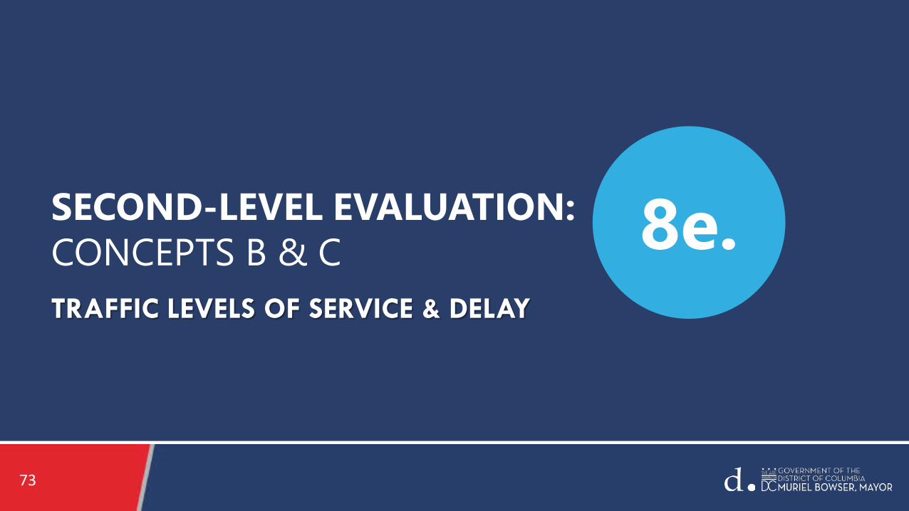
SECOND-LEVEL EVALUATION: CONCEPTS B & C 8e.

7474
Intersection Level of Service and Delay
• Level of Service (LOS) and Delay, were reported and assessed at each of the study area intersections.
• LOS and Delay– See Grading System, LOS “A” to LOS “F” – Overall signalized LOS: Average total vehicle delay of all
movements through an intersection
• LOS and Delay reported is for the highest one peak hour in the morning and the highest one peak hour in the evening.
• An intersection will likely operate better than what is reported during the balance of the day (approximately 20-22 hours).
LOSControl Delay per
vehicle(seconds per vehicle)
A ≤ 10
B > 10-20
C > 20-35
D > 35-55
E > 55-80
F > 80
Second-Level Evaluation

75
AM PEAK HOURPRIMARY & SECONDARY STUDY AREAS
NO-BUILD CONCEPT B CONCEPT C*
# of Intersections with Overall LOS “F” (Total # of Study Area Intersections)
3(44)
3(44)
4(44)
Intersections Operating at LOS “F” under 2045 No-Build, Concept B or Concept C conditions:
Primary• Nebraska Ave & Connecticut Ave (All Conditions)
Secondary Study Area• Nebraska Ave & Broad Branch Rd (All Conditions) • Beach Dr & Park Rd/Tilden St (All Conditions) • Nebraska Ave & Ward Circle N. (“E” to “F” - Concept C)
Second-Level EvaluationAM Peak Hour Level of Service (LOS) Results
Primary & Secondary Study Areas - No-Build, Concepts B & C
*Traffic demands are different under Concepts B and C due to capacity constraints along Connecticut Avenue

76
PM PEAK HOURPRIMARY & SECONDARY STUDY AREAS
NO-BUILD CONCEPT B CONCEPT C*
# of Intersections with Overall LOS “F” (Total # of Study Area Intersections)
5(44)
5(44)
4(44)
Second-Level EvaluationPM Peak Hour Level of Service (LOS) Results
Primary & Secondary Study Areas - No-Build, Concepts B & C
Intersections Operating at LOS “F” under 2045 No-Build, Concept B or Concept C conditions:
Primary• Nebraska Avenue & Connecticut Avenue (All Conditions)• Cathedral Ave & Connecticut Ave (“F” to “E” - Concept C)
Secondary Study Area• Western Ave & River Rd (All Conditions) • Reno Rd & Military Rd (All Conditions) • Nebraska Ave & Ward Circle N. (All Conditions)
*Traffic demands are different under Concepts B and C due to capacity constraints along Connecticut Avenue

77
Traffic Analysis Conclusions
• Levels of service (i.e., capacity and delay) for Concepts B and C include diversions to secondary study area and regional roadways.
• Concept C diverts more traffic than Concept B due to one (1) less travel lane.
• Study Area intersections with LOS “F” during highest AM and PM Peak hours:– 2045 No-Build: AM/[PM]: 3/[5] of 44 – Concept B: AM/[PM]: 3/[5] of 44 – Concept C: AM/[PM]: 4/[4] of 44
• Delays would result for the overall intersection as well as for individual intersection approaches.
• Modeled diversions must occur for traffic operations to operate at acceptable levels of service for some intersections along Connecticut Avenue.
Second-Level Evaluation

78
Traffic Analysis Conclusions: Travel Time
• Estimated Travel Times along Connecticut Avenue (i.e., Peak Direction/Peak Hour) – AM Peak Hour (Southbound)
Concept B/ [C]: +3 minutes/[+7 minutes] compared to 2045 No-Build– PM Peak Hour (Northbound)
Concept B/ [C]: +4 minutes/[+8 minutes] compared to 2045 No-Build
Second-Level Evaluation

7979
Traffic Analysis – “What-if” Assessment
• What-if the magnitude of AM and PM Peak Period diversions are less then modeled?– Intersection delay would increase; Level of Service (LOS) “F” conditions may not be mitigated by
signal timing adjustments.– Corridor travel times would be longer.– Modal shifts and behavioral changes (e.g., more teleworking) would need to occur.
• What-if Concept B and C (Year 2045) traffic volumes are 10-20% lower than modeled due to modal shifts or behavioral changes such as increased teleworking?– Intersections LOS would improve.– Corridor travel times would improve.– Less diversion would occur.
Second-Level Evaluation

8080
QUESTIONS AND COMMENTS
9.

8181
Closing 10.
8282
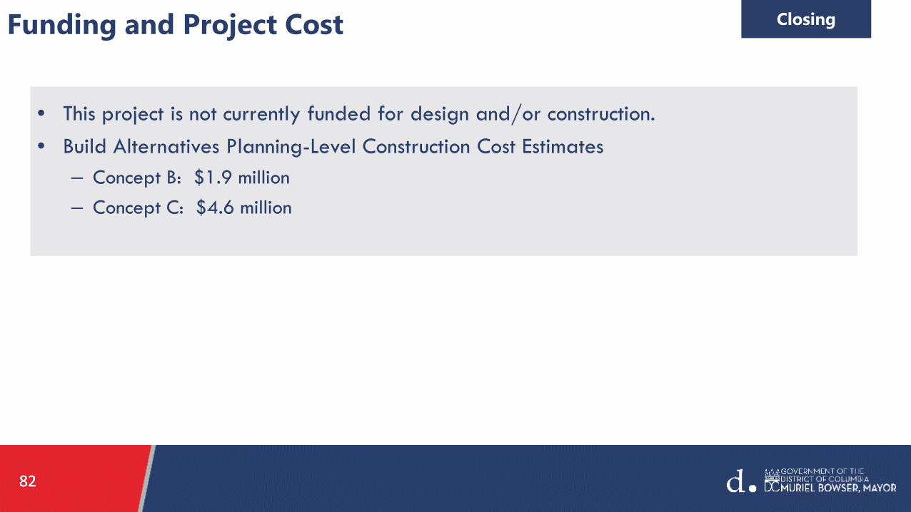
Funding and Project Cost Closing
• This project is not currently funded for design and/or construction. • Build Alternatives Planning-Level Construction Cost Estimates
– Concept B: $1.9 million– Concept C: $4.6 million

8383
Your Comments Closing
• 30 Day Comment Period: We will collect your formal comments over the next 30 days.
• Please send your comments through the Title VI Form for documentation. This form is one of the key avenues through which DDOT documents your formal comments.
– The Title VI form will be automatically provided when you exit the WebEx General Public Meeting.– Please Click "continue" at the close of the meeting when the pop-up window appears, it will take you to
the Title VI Form.– DDOT will also email the Title VI Form after the meeting; You can also access the Title VI form
at rebrand.ly/ctave-titlevi
• Q&A during this Meeting: We will keep a record of the Questions & Answers noted during the Public Meeting and will publish them to the project website.

84
Title VI Survey – rebrand.ly/CtAve-TitleVIAs a recipient of Federal assistance, DDOT must ensure that all of its programs, activities and public meetings are conducted in compliance with Title VI of the Civil Rights Act of 1964. This Act ensures nondiscrimination based on race, color or national origin. The Title VI Public Meeting Participant Questionnaire is used to help DDOT ensure that we are informing the public and conducting our meetings in a nondiscriminatory manner, in compliance with Title VI.
Project comments and/or concerns should be submitted through this form after the Public Meeting for documentation. We appreciate anyone who is willing to complete the form.
Thank you for your participation.
Closing

8585
What Happens Next? Closing
• Thank you for your attendance at the General Public Meeting and Learning Rooms today.
• We will collect your comments and prepare a recommendation for DDOT Management to consider.– May 1st through June 15th
• DDOT Management Recommendation by June 30th.
• If a Build Alternative is selected, Staff will proceed with developing a 10% Design, followed by Environmental Documentation.
• We anticipate holding Public Meeting #2 at the end of the project study period (Fall 2021).

8686
We will have telephone hours for those persons who wish to gain further information after Public Meeting #1.
Virtual Office Hours will occur every Tuesday & Thursday from 2-4 p.m. during the 30-day public comment period.
Virtual office hours will begin on April 6th and conclude on April 29th.
Please call: 1-888-484-8424
Virtual Office Hours Closing

87
Contact Information
Ed Stollof, Project ManagerManager, Project Planning BranchPlanning and Sustainability DivisionEmail: [email protected]
Cynthia Lin, Deputy Project ManagerProject Planning BranchPlanning and Sustainability DivisionEmail: [email protected]
Donise Jackson, DDOT Ward 3 Community Engagement SpecialistOffice of the DirectorEmail: [email protected]
Charlotte Ducksworth, Community Engagement SpecialistPartner and Vice President of Business Affairs, Commun-ET, LLCEmail: [email protected]
Ian Swain, Community Engagement SpecialistManaging Partner, Commun-ET, LLCEmail: [email protected]
Project [email protected]
Project Website https://ddot.dc.gov/page/connecticut-avenue-nw-reversible-lane-safety-and-operations-study
PUBLIC OUTREACH

8888
Thank You!
Title VI Questionnaire to Follow


![Skaffold - storage.googleapis.com · [getting-started getting-started] Hello world! [getting-started getting-started] Hello world! [getting-started getting-started] Hello world! 5](https://img.dokumen.tips/doc/110x75/5ec939f2a76a033f091c5ac7/skaffold-getting-started-getting-started-hello-world-getting-started-getting-started.jpg)