Embed Size (px)
Citation preview

Watershed Monitoring Data Management Protocols, version 6
Division of Environmental Assessment and Restoration Florida Department of Environmental Protection
July 2016
2600 Blair Stone Road, MS 3525 Tallahassee, Florida 32399-2400
www.dep.state.fl.us
Data Management Protocols Version 6, updated 07/26/2016 Z:\datamgmt\Manuals, Instructions\WMS-DataManagementSOP.docx
2
Table of Contents
Introduction ...................................................................................................................................... 3 Project Preparation ......................................................................................................................... 4
Definition of Project ....................................................................................................................... 4 Current Project Types ................................................................................................................. 5 Historic Project Types ................................................................................................................. 5
LIMS Scheduling ............................................................................................................................ 5 List of Stations ................................................................................................................................ 5 Project Paperwork .......................................................................................................................... 5
Site Reconnaissance and Stations Maintenance ............................................................................ 6 Site Reconnaissance ....................................................................................................................... 6 Site/Station Data Maintenance ....................................................................................................... 6
Status Network Stations .............................................................................................................. 6 Minimum Data Requirements for Stations ..................................................................................... 7 Updating Existing Station Data ...................................................................................................... 8 Batch Station Updates to Existing Data ......................................................................................... 9
Data Transfer ................................................................................................................................... 9 Status Network Field Data Transfer ............................................................................................... 9 Trend Field Data Transfer .............................................................................................................. 9
Acceptable Transfer Formats for Trend Field Data .................................................................. 12 Field Data Submittal Deadlines .................................................................................................... 13 Field Data Paperwork (Status and Trend) .................................................................................... 13
Lab Data Submittal ................................................................................................................... 13 Project Processing .......................................................................................................................... 13
Provisional Data Review .............................................................................................................. 13 Data Correction ............................................................................................................................ 15 Project Data Release ..................................................................................................................... 15
Certification of Data for Release ............................................................................................... 15 General Release Databases ....................................................................................................... 16 Deletion of Data from Release Database .................................................................................. 16
Data Notifications........................................................................................................................... 16 Data Security .................................................................................................................................. 17
Oracle Database ............................................................................................................................ 17 Data Management Deadlines ........................................................................................................ 18 Data Availability ............................................................................................................................ 18

Data Management Protocols Version 6, updated 07/26/2016 Z:\datamgmt\Manuals, Instructions\WMS-DataManagementSOP.docx
3
Introduction The Watershed Monitoring Section (WMS) of the Florida Department of Environmental
Protection (DEP) oversees data flow through the use of several platforms, including an Oracle®
database, internet applications, Microsoft® (MS) Access applications, and standard data transfer
formats in dBASE and MS Excel. Collectively, these platforms are referred to as the Oracle
Generalized Water Information System (OGWIS).
This document outlines the normal data management protocols to be used for any project
scheduled by the WMS. The protocols follow the progress of the project to its conclusion, marked
by the final release of data to the general public. These protocols are, for the most part, managed
by Internet applications known as ADM (Automated Data Management), and GWIS Database
Utilities, which allow contractors/staff to edit, update, and export data generated by the WMS.
ADM, developed by WMS staff, is an Oracle forms application used to retrieve and update data
within the WMS’ Oracle database. ADM may be used to track the progress of individual projects
(from preparation through release of the data), to review data, and to generate reports from the
data. A Users’ Manual for ADM is found
at http://publicfiles.dep.state.fl.us/dear/watershed%20monitoring/documents/WMS-
ADMManual.pdf.
GWIS Database Utilities is an online Active Server Page (ASP) application, which interacts with
the WMS’ Oracle database. It is used to enter site reconnaissance (recon) information and for
updating station information. A Users’ Manual for the Database Utilities is found
at http://publicfiles.dep.state.fl.us/dear/watershed%20monitoring/documents/WMS-
GWISManual.pdf.
Data Management Protocols Version 6, updated 07/26/2016 Z:\datamgmt\Manuals, Instructions\WMS-DataManagementSOP.docx
4
Project Preparation Definition of Project
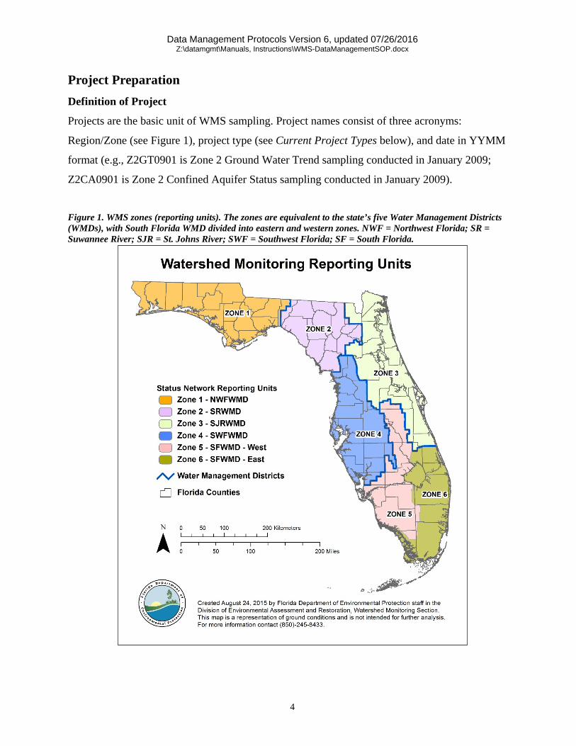
Projects are the basic unit of WMS sampling. Project names consist of three acronyms:
Region/Zone (see Figure 1), project type (see Current Project Types below), and date in YYMM
format (e.g., Z2GT0901 is Zone 2 Ground Water Trend sampling conducted in January 2009;
Z2CA0901 is Zone 2 Confined Aquifer Status sampling conducted in January 2009).
Figure 1. WMS zones (reporting units). The zones are equivalent to the state’s five Water Management Districts (WMDs), with South Florida WMD divided into eastern and western zones. NWF = Northwest Florida; SR = Suwannee River; SJR = St. Johns River; SWF = Southwest Florida; SF = South Florida.

Data Management Protocols Version 6, updated 07/26/2016 Z:\datamgmt\Manuals, Instructions\WMS-DataManagementSOP.docx
5
Current Project Types
GT - Ground Water Trend ST - Surface Water Trend UA - Status Unconfined Aquifer CA - Status Confined Aquifer CN - Status Canals SS - Status Streams LR - Status Rivers SL - Status Small Lakes LL - Status Large Lakes SP - Special Projects
Historic Project Types
B - Background M - Ground Water Temporal Variability, Monthly/Quarterly T - Surface Water Temporal Variability, Monthly V - VISA (Very Intense Study Areas for ground water protection) LS - Status Low Order Stream HS - Status High Order Stream
LIMS Scheduling
For each project, the samplers estimate the number of samples to be collected during each week of
the sampling period. This information is given to the WMS Project Managers (PMs) and Quality
Assurance Officer (QAO). The QAO schedules the sampling on the DEP Laboratory Information
Management System (LIMS). The WMS Data Manager (DM) then enters the Lab Requisition
(RQ) numbers and ancillary data into the table T_RQ_LIST in the Oracle database. This
information is used to create RQ labels for the custody sheets.
List of Stations
Periodically, the stations and blanks to be sampled per project are loaded into the table
T_PENDING in the Oracle Database. This information is used to create the bar code labels for the
sample containers and custody sheets.
Project Paperwork
Two weeks prior to a project begin date, either a PM or the DM will generate the necessary
project paperwork. Please refer to the WMS Sampling Manual

Data Management Protocols Version 6, updated 07/26/2016 Z:\datamgmt\Manuals, Instructions\WMS-DataManagementSOP.docx
6
(http://publicfiles.dep.state.fl.us/dear/watershed%20monitoring/documents/WMS-
SamplingManual.pdf) for further details on project paperwork.
Site Reconnaissance and Stations Maintenance The site and stations tables reside on the department’s Oracle server as part of the section’s Oracle
database. The database is normally accessed via Internet Explorer (version 6.0 or greater). The
URL for the GWIS Database Utilities Internet application is https://fldep.dep.state.fl.us/gwis.
Please refer to the User’s Manual
(http://publicfiles.dep.state.fl.us/dear/watershed%20monitoring/documents/WMS-
GWISManual.pdf) for instructions concerning site reconnaissance and station maintenance.
Site Reconnaissance
The sampling agency, PMs, and/or other DEP staff perform all site reconnaissance activities
(see http://publicfiles.dep.state.fl.us/dear/watershed%20monitoring/documents/WMS-
ReconManual.pdf for a detailed Reconnaissance Manual). After field/office reconnaissance has
been performed, reconnaissance information is stored in Oracle, using the Recon Tracking Utility
in GWIS Database Utilities.
Site/Station Data Maintenance
Responsibility for site/station data maintenance, such as updates to owner information, is
addressed by the appropriate PM. Typically, individual updates and additions are done by the PM
or sampling staff via GWIS Database Utilities. The DM initiates batch additions and updates at
the request of the PM. The DM or PMs add all new stations to the database.
Status Network Stations
1. The WMS Data Analyst (DA) works with the US Environmental Protection Agency (EPA)
to generate all new Status Network random site selections for surface water (SW) and
ground water (GW) resources (for further details, see the WMS Monitoring Design
Document, http://publicfiles.dep.state.fl.us/dear/watershed%20monitoring/documents/WM
S-MonitoringDesignDocument.pdf).
2. The site locations are assigned site identifiers by the DA. The DM adds project-specific
data elements.

Data Management Protocols Version 6, updated 07/26/2016 Z:\datamgmt\Manuals, Instructions\WMS-DataManagementSOP.docx
7
3. The SW site data are then loaded into the table T_RANDOM_SAMPLE_LOCATION, and
the GW site data are loaded into the table T_WELL_LISTFRAME in the GWIS schema of
the Production Oracle database.
4. All Status Network SW sites are considered potential new stations. These sites are used to
create new stations in the T_STATION table if they are sampled and locational data
received. Each site in T_RANDOM_SAMPLE_LOCATION which is sampled is updated
with the primary identifier found in T_STATION for the station which relates to the site.
5. Occasionally, a site must be resampled due to issues with the samples being received in a
timely manner in the laboratory or issues with the laboratory analyses after the samples are
received. In these cases, the data will be stored as different samples.
a. If the original site and resample site have a different latitude and longitude, two
different stations with unique PK_STATION numbers will be created and
associated with the two sets of data. The original site’s STATION_NAME and
FK_RANDOM_SAMPLE_LOCATION (if applicable) will be appended with the
letter “B”. The resample site will have the same STATION_NAME and
FK_RANDOM_SAMPLE_LOCATION (if applicable) as the original site but
without the appended letter “B”.
b. If the original site and resample site have the same latitude and longitude, only one
station will be created for the two sets of data.
6. Once GW wells are sampled for a project their site and physical well information is used to
either 1) update an existing well in T_STATION, if the well/station is currently in
T_STATION, or 2) create a new well/station record if the well/station does not exist in
T_STATION. A package on the database, GWIS_ADMIN.pkg_process_status_station, is
run to accomplish this. This procedure also updates the Random_Sample_Location
identifier in T_STATION, and the station’s primary identifier in T_WELL_LISTRAME.
7. Note: the PM or sampling staff must check/enter the minimum data required whenever a
new station is added to the Station table.
Minimum Data Requirements for Stations
• For a GW well to be included into the database the following information is required, as
defined in the current GWIS Database Data Dictionary (found
at \\FLDEP1\SOL_Z\datamgmt\Manuals, Instructions\GWIS DATABASE DATA

Data Management Protocols Version 6, updated 07/26/2016 Z:\datamgmt\Manuals, Instructions\WMS-DataManagementSOP.docx
8
DICTIONARY 1.5.pdf): STATION NAME, WATERBODY NAME, WATER
RESOURCE, LATITUDE, LONGITUDE, LOCATION METHOD, LOCATIONAL
DATUM, CASING DIAMETER, CASING MATERIAL, CASING DEPTH, TOTAL
DEPTH, CONTACT INFORMATION, and DATA SOURCE. A statement describing why
the well was selected for inclusion should be supplied with the electronic data in the
comment column for the well(s).
• For a SW station to be included into the database the following information is required, as
defined in the current GWIS Database Data Dictionary (found
at \\FLDEP1\SOL_Z\datamgmt\Manuals, Instructions\GWIS DATABASE DATA
DICTIONARY 1.5.pdf): STATION NAME, USGS HYDROLOGIC UNIT,
WATERBODY TYPE, WATERBODY NAME, WATER RESOURCE, LATITUDE,
LONGITUDE, LOCATION METHOD, LOCATIONAL DATUM, CONTACT
INFORMATION, and DATA SOURCE. A statement describing why the station was
selected for inclusion should be supplied with the electronic data in the comment column
for the station(s).
• In addition to the above mentioned data elements, the samplers and/or PMs should make
every effort to fill in as much information for the station as appropriate and possible via
GWIS Database Utilities (see below for station updates).
Updating Existing Station Data
Periodically, some of the data for a station (either GW or SW site) may change (e.g., ownership of
a well may change). Updates to reflect these changes should be made in a timely manner by either
the WMS PM or the contracted sampling staff. Existing station data can be updated in the
following manner.
1. Select Existing Station from the main menu of GWIS Database Utilities.
2. Retrieve the station by entering the station name or typing in the first few characters of the
name, and then clicking Submit.
3. From the list of retrieved stations, locate the station of interest, and click on the
hyperlinked station ID.
4. Using the tabs, locate the form page that contains the data element in need of updating.
5. Make updates as necessary, and click Save.
Data Management Protocols Version 6, updated 07/26/2016 Z:\datamgmt\Manuals, Instructions\WMS-DataManagementSOP.docx
9
Batch Station Updates to Existing Data
Requests for large-scale updates to T_STATION should be made to the DM.
Data Transfer Status Network Field Data Transfer
Status Network field data transfer is made via a field data entry program installed on the samplers’
Trimble® Global Positioning System (GPS) data loggers. The resultant files are then forwarded to
the WMS PM via Internet, diskette, or other mutually acceptable electronic media. Details of the
management of these data are found in the “Status Monitoring Network GPS Data Management
Procedures” Appendix in the Design Document.
Trend Field Data Transfer
Trend Network field data transfer is made via an online data entry page, or in a standardized
format that has been approved by the DM. To use the online application:
1. Open Internet Explorer 6.0 or higher (do not use Google Chrome), and go
to https://fldeploc.dep.state.fl.us/ambient/field.
2. Click Surface Water, Springs, or Ground Water, depending on the type of data to be
entered.
3. Then, select the zone/agency you are entering data for from the table provided. This will
take you to the actual field data entry form.
4. Select a Trend station from the Station dropdown list.
5. Select the month and year of the sampling project from the Trend Project dropdown lists.
6. Enter the date on which samples were taken using the Sample Date dropdown lists.
7. Select the Sample Time in the boxes provided (note that Primary and Bottom samples
coming from the same station must have different sample times, and that the time is in 24-
hour format).
8. Select a Sample Type (Primary(Surface) or Bottom) from the dropdown list
9. Enter the name of the person(s) collecting samples in the Sampler’s Name(s) box. Do not
use initials. Names should be spelled out. There is a 50-character limit.
10. Enter Your Name into the box provided. You must enter a name, or else submission of the
form will be rejected. Do not use initials. Your name should be spelled out.
11. Enter the field data in the appropriate fields of the form:
Data Management Protocols Version 6, updated 07/26/2016 Z:\datamgmt\Manuals, Instructions\WMS-DataManagementSOP.docx
10
a. Starting at the top of the Parameter list, type in the Value measured in the field. If
no measurement was made, leave the Value null, add an ‘O’ in the Value Qualifier
field and make the appropriate Comments.
b. Select any pertinent Value Qualifiers associated with each measurement. A list of
acceptable value qualifiers is available by clicking on the provided link.
c. Type in any comments pertaining to that particular measurement into the Comment
box. There is an 80-character limit.
d. Follow this procedure until all of the field measurements are entered.
12. Any comment pertinent to the station as a whole may be entered into the Comments field
at the bottom of the form. Again, there is an 80-character limit.
13. If data entry is complete, review the entries on the screen for accuracy, and click Submit.
14. To clear the form and start over, click Reset.
15. Once you click Submit, you will get a confirmation screen. To enter data for another
station click the “Return to Form” link, and follow the preceding steps for the next station.
16. When you have completed entering all the data, be sure to e-mail a notification back to
DEP WMS to let us know the data are waiting. An e-mail link, which is already addressed,
is provided via the application.
Within 30 days of receipt, DEP will download the submitted data from the web server. These data
are then loaded into the table T_FIELD_DATA in OGWIS, and the column
DATE_FIELD_DATA in T_PROJECT is updated.
For sampling staff who do not have Internet access, Trend Network field data transfer shall be via
one of the two standard file formats described on page 12 in the section, Acceptable Transfer
Formats for Trend Field Data. The file will be forwarded to the WMS PM via Internet, diskette, or
other mutually acceptable electronic media.

Data Management Protocols Version 6, updated 07/26/2016 Z:\datamgmt\Manuals, Instructions\WMS-DataManagementSOP.docx
11
Required Field Measurements - Ground Water This is a three-column table. Column 1 lists the measurement, column 2 lists the unit, and column 3 lists the parameter
code. Note: °C = degrees Celsius; umhos/cm = micromhos per centimeter; mg/L = milligrams per liter; NTU = Nephelometric Turbidity Unit; NGVD = National Geodetic Vertical Datum; N/A = not applicable
MEASUREMENT1 UNITS PARAMETER CODE Water Temperature, field °C 00010 Specific Conductance at 25° C, field umho/cm at 25°C 00094 Dissolved Oxygen, field mg/L 00299 Dissolved Oxygen Percent Saturation, field
Percent 00301
pH, field standard units 00406 Depth to Water from Measuring Point
feet 72109
Turbidity, field2 NTU 82078 Elevation of Measuring Pt., above or below NGVD
feet 82514
Microlanduse3 N/A 84147 1 = Measurements that were required, but were not taken, should be listed as null (empty) values along with an ‘O’ value qualifier and a comment indicating why the measurement was not performed. 2 = Required by DEP SOP as of 8/06/2002, however this is subject to change. 3 = Once per year at Trend sites, and at each Status Site.
Required Field Measurements – Surface Water This is a three-column table. Column 1 lists the measurement, column 2 lists the unit, and column 3 lists the parameter
code. Note: °C = degrees Celsius; umhos/cm = micromhos per centimeter; mg/L = milligrams per liter; NTU = Nephelometric Turbidity Unit; NGVD = National Geodetic Vertical Datum; N/A = not applicable
MEASUREMENT1 UNITS PARAMETER CODE Water Temperature, field °C 00010 Specific Conductance at 25° C, field umhos/cm at 25°C 00094 Dissolved Oxygen, field mg/L 00299 Dissolved Oxygen Percent Saturation, field
Percent 00301
pH, field standard units 00406 Secchi Depth (transparency)2 meters 00078 Total Depth at Sampling Site3 meters 82903 Stream Stage4 feet 00065 Sample Depth meters 90068
1 = Measurements that were required, but were not taken, should be listed as null (empty) values along with an ‘O’ value qualifier and a comment indicating why the measurement was not performed. 2 = If disc is visible on bottom of water body, the ‘S’ value qualifier must be used. 3 = If sampling done from a fixed point. 4 = Surface Water Trend sites only, where available.

Data Management Protocols Version 6, updated 07/26/2016 Z:\datamgmt\Manuals, Instructions\WMS-DataManagementSOP.docx
12
Acceptable Transfer Formats for Trend Field Data
DBF (dBASE® File) Format: This is a four-column table. Column 1 lists the parameter name, column 2 lists the parameter type, column 3 lists the
total number of characters or digits, and column 4 lists the number of decimal digits.
NAME TYPE TOTAL CHARACTERS OR
DIGITS
DECIMAL DIGITS
STATION CHARACTER 25 N/A PARAM_CODE NUMERIC 5 0 PARAM_NAME CHARACTER 40 N/A TEXT_VALUE CHARACTER 11 N/A
VAL_QUAL CHARACTER 5 N/A SAMP_DATE CHARACTER 8 N/A SAMP_TIME CHARACTER 4 N/A SAMP_SEQ CHARACTER 2 N/A
SAMP_TYPE CHARACTER 1 N/A PROJECT CHARACTER 30 N/A
COMMENT CHARACTER 80 N/A SAMPLER CHARACTER 50 N/A
Microsoft® Excel Format:
This is a four-column table. Column 1 lists the parameter name, column 2 lists the parameter type, column 3 lists the total number of characters or digits, and column 4 lists the number of decimal digits.
NAME TYPE TOTAL
CHARACTERS OR DIGITS
DECIMAL DIGITS
STATION TEXT* 25 N/A PARAM_CODE NUMERIC 5 0 PARAM_NAME TEXT 40 N/A TEXT_VALUE TEXT 11 N/A
VAL_QUAL TEXT 5 N/A SAMP_DATE TEXT 8 N/A SAMP_TIME TEXT 4 N/A SAMP_SEQ TEXT 2 N/A PROJECT TEXT 30 N/A
COMMENT TEXT 80 N/A SAMPLER TEXT 50 N/A
* = All text columns to be left justified
Please refer to the WMS’ Field Database Data Dictionary Version 2.6
at \\FLDEP1\SOL_Z\datamgmt\Manuals, Instructions\FIELD_V2.6.doc for data element
definitions.

Data Management Protocols Version 6, updated 07/26/2016 Z:\datamgmt\Manuals, Instructions\WMS-DataManagementSOP.docx
13
Field Data Submittal Deadlines
Deadline for Trend and Status field data submittal is 30 days from project end date (the day that
the last sample was collected for the project).
Field Data Paperwork (Status and Trend)
Copies of all relevant paperwork for the project, including sample custody records and the list of
stations actually sampled, should be mailed to the WMS PM within 30 days from the project end
date.
Lab Data Submittal
Once all analyses for a project are completed, the DEP lab transfers the receipt, result, and QA/QC
records to AMBIENT holding tables on its Oracle database in the schema VGSM. Then these data
are transferred directly to the WMS Oracle database via PL/SQL procedures that are scheduled to
run weekly every Monday night at 7pm.
Project Processing 1. Once all lab and field data for a project are loaded into the WMS Oracle database, the DM
runs a series of PL/SQL procedures to normalize the data. During this process, each sample
is spot checked for missing analytes. Furthermore, the DM checks for missing stations. The
resultant data are held in temporary tables in the WMS Oracle database
(T_PROVIS_SAMPLE and T_PROVIS_RESULT).
2. Once all of the data have been accounted for and any necessary edits made, they are
transferred to the tables T_SAMPLE and T_RESULT, and the column
DATE_PROVISIONAL in T_PROJECT is updated.
Provisional Data Review
After the DM has normalized the files, the appropriate staff are notified that the data are ready for
review using ADM. Detailed instructions are given below.
1. Open ADM, enter the project of interest and click -Search to load the project data.
Select the Review tab. If the data for the project have been normalized, there should be a
date listed beside ‘Provisional’. If this is the case, the operator may run the Database
Checks by clicking Run Checks.

Data Management Protocols Version 6, updated 07/26/2016 Z:\datamgmt\Manuals, Instructions\WMS-DataManagementSOP.docx
14
2. A PDF file will be created and opened in the internet browser. The document contains the
name of the project, the date the checks were run, a count of the stations sampled and
blanks collected, the number of analytes per station and sample type, missing analytes per
station, detections coming from associated blanks, measurement range checks,
measurements reporting negative values, and samples with excessive turbidity.
3. The purpose of this file (commonly referred to as the project’s documentation file or
metadata file) is to document the life history of the project’s data. Comments documenting
any changes made to the data, or referring to any unusual results, should be included in the
Comments section of the file using the text entry box under Project Comments.
4. Run Checks must be performed before project data can be released (see below).
Once the documentation file is created and reviewed by the WMS PM, it may be forwarded to the
sampling contractor and/or sampler for review. MS Excel exports of the project data and the
project’s blank data should be submitted for review at the same time. These exports are created
within ADM by navigating to the Reports tab, and selecting Result Data and Blank Data from
the Open Data View window. These files are opened in the internet browser, where they are saved
as text (.txt) files and then converted to MS Excel files by the WMS PM. The PM also has the
option to retrieve project data in one of two pivot formats. Pivot Table Value (Number) retrieves
T_RESULT.VALUE whereas Pivot Table Value (Text) retrieves T_RESULT.VALUE_TEXT. In
order to review results that are only stored as text (e.g. Water Sample Collection Device), the PM
should use Pivot Table Value (Text). The Metadata button will open an existing documentation
file for the selected project if the Run Checks button on the Review tab has been used (discussed
in Provisional Data Review above). Data exports from ADM do not include all data associated
with the project from T_SAMPLE and T_STATION.
The data exports from ADM mentioned above are not for permanent storage and they should not
be re-used to fill data requests. If a data request is made, the PM should generate a new
spreadsheet to send at that time. The procedure for regenerating spreadsheets does not vary from
the initial creation procedure. In addition, corrections by PMs or samplers should not be made to
these spreadsheets, as they will never make it to the database (see Data Correction below).

Data Management Protocols Version 6, updated 07/26/2016 Z:\datamgmt\Manuals, Instructions\WMS-DataManagementSOP.docx
15
Data Correction
Updates and additions to the Stations table are made through the GWIS Database Utilities
application as described in the Site/Station Data Maintenance section above. PMs are granted
access, and changes/additions are made at their discretion.
Sample data corrections are made through a form review process. PMs send requests for sample
data correction to the WMS DM for review and update of the appropriate Oracle tables. Data
reviewers at contracted sampling agencies can also submit requests for data correction through
their PM.
Requested data corrections are submitted on a copy of the Sample Data Correction Request Form
at \\Fldep1\sol_z\datamgmt\GWIS Sample Data Corrections. More extensive, systematic changes
can be requested by e-mail, as long as all pertinent data are included. Correction requests are dated
upon receipt, annotated with action taken and date action taken, copied, and the original returned
to the PM.
Any editing changes made to a database are documented in the project's documentation file (see
project’s documentation file, under the section Provisional Data Review above). Furthermore, the
DM updates the comment columns of the sample and/or results table to reflect any editing changes
made to either of these two tables.
Project Data Release
Certification of Data for Release
1. Certification for public release can come only after the review of the project data and the
metadata file (see Provisional Data Review above), and after any needed editing has been
completed and reviewed.
2. The WMS Project Manager and, if applicable, the contracted sampling agency’s data
reviewer must approve the data before it is certified for release. The only exception occurs
if the data review time period (see Data Management Deadlines below) has expired, and
DEP deems it necessary to release the data so that data analysis may proceed.
3. Project status is upgraded to Release in ADM, via the Review tab’s Release button. A note
adding the date the data were deemed released and who approved the data for release

Data Management Protocols Version 6, updated 07/26/2016 Z:\datamgmt\Manuals, Instructions\WMS-DataManagementSOP.docx
16
should be added to the project’s documentation file (refer to ‘project’s documentation file’,
under the section Provisional Data Review above).
4. In rare instances data may be unreleased via the Review tab’s Revert Release button. This
should only occur when egregious errors are noted in released data. If data are ‘unreleased’
any noted errors causing this action must be corrected and the data must be reviewed again
before they are released. The PM should obtain approval from the DM and, if applicable,
the contracted sampling agency’s Project Manager before unreleasing any data.
A report that contains target dates for each project and whether or not they have been met can be
generated using the Project Status Report button in the ADM Review tab. This report is
generated as a PDF file in the web browser.
General Release Databases
1. Once provisional data have been reviewed, edited, and certified as being ready for general
release, exports of the data can be distributed for general use. It is important to use ADM to
create a current export of the data directly from the Oracle Database for each request,
because any changes made to the data will be reflected in the current export. There is no
guarantee that prior exports will be up to date with edits/changes that may have been made
to the database.
2. Newly released data will also be loaded to the Florida STORET database on a monthly
basis.
Deletion of Data from Release Database
To be physically deleted from the database, data must meet at least one of the following criteria:
data were collected in obvious violation of sampling agreement with station owner; data were not
collected for a WMS Monitoring Network.
Data Notifications Letters, data reports, and notifications for exceedances of water quality thresholds will be created
and forwarded to other programs within DEP, the Florida Department of Health, and property
owners, as referenced in the WMS Project Manager Manual
(http://publicfiles.dep.state.fl.us/dear/watershed%20monitoring/documents/WMS-

Data Management Protocols Version 6, updated 07/26/2016 Z:\datamgmt\Manuals, Instructions\WMS-DataManagementSOP.docx
17
ProjectManagerManual.pdf). When all required letters for each project have been sent, Project
Managers use the Record Date button in the ADM Reports tab to document that the notifications
are complete.
The Reports tab in ADM also contains information about each project’s notification status
(Notification Status Report button). This button generates a file in the web browser listing which
contacts/owners have requested letters and displays the date that the project’s letters are sent.
Data Security Oracle Database
The database is located on the department’s depdbprod.dep.state.fl.us server.
Once loaded to the WMS Oracle Database, each sample data record is locked and changes are
solely permitted by the WMS DM. However, updates to the Comment column of the Project Table
will be made available to the PMs and contractors via the ADM Application. Updates to the
STATIONS tables will be allowed via GWIS Database Utilities, https://fldep.dep.state.fl.us/gwis,
as indicated in the GWIS Database Utilities User's Manual.
The Agency for State Technology (AST) is responsible for data backups. Full Recovery Manager
(RMAN) is used to perform backups of the database, along with transaction logs, every Monday
through Saturday night. This allows for point in time recovery of the database. Oracle Export
backups are performed at the same time.
DEP Database Administrators (DBA’s) are responsible for performing Oracle schema exports.
These exports are available only for short term retention.

Data Management Protocols Version 6, updated 07/26/2016 Z:\datamgmt\Manuals, Instructions\WMS-DataManagementSOP.docx
18
Data Management Deadlines Note: due dates are from project end date, the day on which the final sample for the project was
taken.
Item Due Date Field Data Receipt 30 days Lab Data Receipt 90 days Provisional DBF Creation 120 days Project Review/Data Release 240 days Letter to Owner/contact Person 360 days Dept. of Health Notification 360 days
Data Availability Data are available from the DEP upon request; for availability and access please refer
to http://www.dep.state.fl.us/water/monitoring/data.htm.