Embed Size (px)
Citation preview
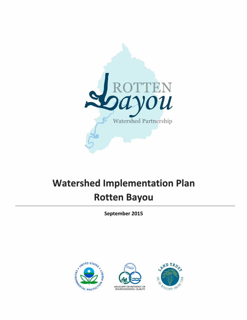
Watershed Implementation Plan
Rotten Bayou
September 2015
Prepared For:
Land Trust for the Mississippi Coastal Plain
P.O. Box 245 Biloxi, Mississippi 39533
228.435.9191 www.ltmpc.org
Prepared By:
Gulf Coast Community Design Studio
Mississippi State University, College of Architecture, Art + Design 769 Howard Avenue
Biloxi, Mississippi 39530 228.436.4661
www.gccds.org
With Acknowledgements for Contributions Made By:
City of Diamondhead 5000 Diamondhead Circle
Diamondhead, Mississippi 39525
Diamondhead Country Club and Property Owners Association 7600 Country Club Circle
Diamondhead, Mississippi 39525
Hancock County 854 Highway 90
Bay St Louis, Mississippi 39520
Harrison County 1801 23rd Ave
Gulfport, Mississippi 39501
Steering, Technical, and Education and Outreach Committees

Table of Contents
Section 1: Watershed Planning
1.1 Development of a WIP 1
1.1.1 What is a WIP? 1
1.1.2 Why create a WIP for Rotten Bayou? 2
1.1.3 Process and Acknowledgements 4
1.2 Looking Forward 5
1.2.1 Watershed Implementation Team 5
1.2.2 Assets, Concerns and Challenges 7
1.2.3 Vision 8
1.2.4 Goals and Objectives 8
1.3 Related Plans and Projects 9
Section 2: Watershed Assessment
2.1 History and Land Use 11
2.1.2 Historical Context 11
2.1.3 Current and Future Land Use 15
2.2 Human Resources 16
2.2.1 Demographics 16
2.2.2 Municipal 16
2.2.3 Civic Infrastructure 17
2.3 Physical Setting 18
2.3.1 Soils and Geology 18
2.3.2 Ecoregion 21
2.3.3 Wetlands 21
2.3.4 Climate and Climate Change 23
2.3.5 Conservation Mapping 26
2.4 Water Resources 27
2.4.1 Groundwater 27
2.4.2 Water Conservation 28

2.4.3 Access and Recreation 28
2.4.4 Wildlife and Fisheries 29
2.4.5 Designated Use Classifications and Water Quality Standards 29
2.4.6 Current Status of Water Bodies 31
2.4.7 Sources of Pollutions 38
2.5 Key Findings: Challenges and Opportunities 39
Section 3: Management and Monitoring Plans
3.1 Watershed Management Actions 41
3.1.1 Current Management Actions 41
3.1.2 Planned Management Actions 45
3.2 Education and Outreach Activities 56
3.2.1 Summary of Activities Conducted During the Planning Period 56
3.2.3 Future Outreach and Education Activities 58
3.3 Plan Evaluation and Revision 60
3.3.1 Monitoring Plan 60
3.3.2 Adaptive Management and Plan Revisions 62
Appendices:
A: Soil Survey
B: Mississippi National Heritage Inventory
C: Rotten Bayou Water Quality Assessment
D: Final Report: Rotten Bayou Watershed Agricultural Nonpoint Source Pollution Project
E: Diamondhead Cardinal Golf Course BMPs
F: Diamondhead Duck Pond Demonstration Project
G: Priority Projects
H: Management Actions
I: Recommended Ordinance Changes
J: Model Ordinance for Florida-Friendly Fertilizer Use on Urban Landscapes
K: Sample Boy Scout Projects for Rotten Bayou Watershed
L: Elementary Education for Rotten Bayou Watershed
Section 1: Watershed Planning
1.1 Development of a WIP
1.1.1 What is a WIP?
State and federal agencies and organizations have been moving toward a watershed approach to water resource management since the late 1980’s.1 The watershed approach offers a flexible framework to address water quality and other issues within a specific drainage area. Management actions taken within a specific watershed are usually pursuant to an approved watershed plan. A watershed implementation plan is a strategy that provides assessment and management information for a geographically defined watershed, including analyses, actions, participants and resources related to developing and implementing the plan.2 Watershed plans vary to a degree based on the specific water resource impairments identified for the watershed and the concerns and goals of stakeholders involved in the planning process. Most watershed plans, however, include a vision, goals, assessment of current pollutant loads, future load reductions expected from implementing best management practice, a strategy for educating the public and expectations for monitoring and adapting the plan. In addition, the U.S. Environmental Protection Agency (EPA) requires nine elements be included in any watershed plan funded with incremental Clean Water Act section 319 funds and strongly recommends they be included in all watershed plans intended to address water quality impairments (See Table 1).3
Table 1: Cross Walk for Required Elements for WIP
Required WIP Element for 319 Grant Location in WIP
Watershed Description and Background Section 2: Watershed Assessment
Implementation Section 3.1: Watershed Management Actions
Project Goals Section 1.2.4: Goals
Project Costs Appendix H: Management Actions
Education and Outreach Section 3.2: Education and Outreach Activities
Implementation Schedule Appendix H: Management Actions
Milestones Appendix H: Management Actions
Adaptations and Revisions Section 3.3.2: Adaptive Management and Plan Revision
Monitoring Section 3.3.1: Monitoring Plan
States are encouraged to develop statewide watershed planning frameworks to guide watershed plans in their jurisdictions. In 2008 the Mississippi Department of Environmental Quality’s (MDEQ) Basin Management Branch published “Guidance for Developing A Watershed
1
Implementation Plan.” This guide, including the nine elements defined by the EPA for watershed plans receiving section 319 funding, provides the framework for developing the Rotten Bayou Watershed Implementation Plan.
1.1.2 Why create a WIP for Rotten Bayou?
Developing a watershed plan for Rotten Bayou Watershed is a key step in implementing the Coastal Nutrient Reduction Strategy and improving water quality in the watershed.4 The Rotten Bayou Watershed (HUC 031700109-002) is 22,446 acres and lies in Hancock and Harrison Counties. See Figure 1. Rotten Bayou itself is a tributary of the Bay of St. Louis and was listed on the EPA’s 2006 Section 303(d) list of impaired waterbodies for organic enrichment, low dissolved oxygen, turbidity, and nutrient levels that did not meet water quality standards. The main contributors to these environmental stressors do not come from a single source and so require a holistic approach to develop solutions. Nonpoint source pollution can come from excess fertilizers, herbicides and insecticides from agricultural lands and residential areas; oil, grease and toxic chemicals from urban runoff; sediment from improperly managed construction sites, crop and forest lands, and eroding streambanks; and bacteria and nutrients from livestock, pet wastes and faulty septic systems. Addressing causes of nonpoint source pollution in Rotten Bayou Watershed is a primary benefit of creating a watershed plan.
2

Figure 1: Rotten Bayou Subwatershed
Source: Map by Gulf Coast Community Design Studio
In 2011, U.S. Department of Agriculture’s Natural Resources Conservation Services (NRCS) announced the availability of up to 50 million dollars to help rehabilitate sixteen priority watersheds in the five Gulf States over a three-year period. The initiative is part of the Gulf Coast Ecosystem Restoration Task Force, created by Executive Order by President Obama in response to degradation of watersheds within the region, intensified by the Deep Horizon oil
3

spill. Rotten Bayou Watershed and Bayou LaTerre Watershed in the Jourdan River Basin in Mississippi are among the sixteen priority watersheds.5 An approved Watershed Implementation Plan and organized partnership for Rotten Bayou Watershed will improve the chances of bringing funding to the area. A Rotten Bayou Watershed Implementation Plan will also help coordinate and build momentum around the many conservation activities already taking place in the watershed. Natural Resource Conservation Service (NRCS), Soil and Water Conservation District (SWCD), Soil and Water Conservation Commission (SWCC), U.S. Geological Survey (USGS) and Mississippi State University’s Water Resources Research Institute (WRRI) are actively working and funding activities within the Rotten Bayou Watershed as part of an innovative water and wildlife conservation effort along the Gulf Coast called the Gulf of Mexico Initiative (GoMI). Current activities and related plans are further discussed in Section 1.3.
1.1.3 Process and Acknowledgements
In 2012, MDEQ enlisted the Land Trust for the Mississippi Coastal Plain (LTMCP) to guide planning work, education efforts and the implementation of restoration actions in Rotten Bayou Watershed pursuant to an approved Watershed Implementation Plan. Since 2006, LMTCP has worked to develop partnerships and plans for six watersheds in southern Mississippi including Old Fort Bayou, Red Creek, Turkey Creek, Tuxachanie-Tchoutacabouffa, Upper Bay St. Louis and West Boley Creek. The larger Upper Bay St. Louis Watershed includes the Rotten Bayou subwatershed. The Rotten Bayou Watershed Project is funded partly through the EPA’s Non-point Source Grant C9994866-11-0 and partly through State and local match. LTMCP hired Mississippi State University’s Gulf Coast Community Design Studio in December 2013 to facilitate the development of the Watershed Implementation Plan and related outreach and design work. The first step in the planning process was to assemble a Watershed Implementation Team representing various stakeholders in Rotten Bayou Watershed. See Section 1.2.1. This team includes a Steering Committee made up primarily of local leadership and residents, a Technical Advisory Committee consisting of staff from various public agencies and private firms with expertise related to the watershed planning, and an Education and Outreach Committee to guide the public engagement portion of the work. The Steering Committee first discussed assets and concerns related to the watershed and water quality and determined a vision and goals for watershed planning in Rotten Bayou that would guide the committee and future work. See Sections 1.2.2 – 1.2.4. The Steering Committee and Technical Advisory Committee then set to work collecting and analyzing available data related to Rotten Bayou Watershed. This information is included in Section 2 and has informed the ongoing outreach and education efforts, as well as the management and monitoring plans included in Section 3. Natural Capital Development and Anchor QEA, LLC were hired as project consultants between June and December 2014 to analyze available draft water quality data for Rotten Bayou as compared to the TMDL and approved thresholds. See Appendix C: Rotten Bayou Water Quality Assessment. The Education and Outreach Subcommittee was critical to the implementation of public engagement activities carried out during the planning period and development of a plan for future activities. See Section 3.2.
4

1.2 Looking Forward
1.2.1 Watershed Implementation Team
Steering Committee
Adam Hootie Hancock County Emergency Management Agency
Bilbo Holly City of Diamondhead
Bonck Pat Harrison County Planning and Zoning
Chubb Patrick Mississippi Power
Collard Mike Diamondhead Water & Sewer District (through 2014)
Coyne Mary Devil’s Elbow POA/Diamondhead Resident
Depreo Nancy Seymour Engineering/Diamondhead Resident
Flores Karen Diamondhead Garden Club/Diamondhead Resident
Holcomb Hank Diamondhead Resident
Isaacs Mark Solar Boat Tours
Kinchen Darrell Diamondhead POA/Diamondhead Resident
Knobloch Ernie Diamondhead City Council/Diamondhead Resident
Koch David Hancock County Resident
Ladner Marcus Hancock County Resident
Ladner Tony-Wayne Hancock County, District 5 Supervisor
Ladner Marlin Harrison County, District 3 Supervisor
Ladner Robyn Harrison County Planning and Zoning
Lee Eddy Diamondhead Resident
Lopez Joseph Diamondhead City Council/Diamondhead Resident
Necaise Ty Harrison County Resident
Nolan Janell Coast Electric Power Association/Diamondhead Resident
Pyron Jason Diamondhead Resident
Reed Clovis City of Diamondhead/Diamondhead Resident
Rice Karen Keep Diamondhead Beautiful/Diamondhead Resident
Schafer Tommy Diamondhead City Council/Diamondhead Resident
Sentell Brook Diamondhead POA/Diamondhead Resident
Sheehy Ray Diamondhead Resident
Sites Karen Diamondhead Resident
Sloan Dan Diamondhead Resident
Steckler Judy Land Trust for the Mississippi Coastal Plain
Sullivan Richard City of Diamondhead
Thomas Scott Stetson Engineers/Diamondhead Water and Sewer District Commissioner/Diamondhead Resident
Yanez Tracy Mississippi Power/Diamondhead Resident
Technical Advisory Team
Alexander Constance US EPA Region 4
Baker Beth MSU REACH
5

Beard Russell NOAA Center for Coasts, Oceans, and Geophysics/Diamondhead Resident
Boos Jerry EPA Gulf of Mexico Program
Bray Leah Natural Capital
Caviness-Reardon Kim MS Department of Environmental Quality
Dahmash Zoffee MS Department of Environmental Quality
Darby Elaine Anchor QEA
Depreo Nancy Compton Engineering/Diamondhead Resident
Freiman Mike MS Department of Environmental Quality
Fulton Marty Natural Resources Conservation Service
Gallo Cory Mississippi State University
Harrington Tyree Natural Resources Conservation Service
Harris Jared MSU REACH (through 2014)
Hicks Matt US Geological Survey
Ingram Richard MS Water Resources Research Institute
Jackson Greg MS Department of Environmental Quality
Kotey Napolean US EPA Region 4
Lagasse Mickey Compton Engineering
Miller Christian Auburn, MASGC, Mobile Bay Estuary Program
Murphy Mike The Nature Conservancy
Perrott Coen MS Department of Environmental Quality
Pierce Troy EPA Gulf of Mexico Program
Ray Tim MSU Extension – Harrison County/Diamondhead Resident
Rose Kathryn NOAA National Coastal Data Development Center
Schenck-Gardner Betsy NOAA National Coastal Data Development Center
Segrest Natalie MS Department of Environmental Quality
Stephenson Christian MSU Extension – Hancock County Thomas Scott Stetson Engineers/Diamondhead Water and Sewer District
Commissioner/Diamondhead Resident
Upton Doug MS Department of Environmental Quality
Utroska Steven MS Department of Environmental Quality
Viskup Barbara MS Department of Environmental Quality
Vowell Patrick MS Soil & Water Conservation Commission
Wilkerson Wayne MS Water Resources Research Institute (through 2013)
Williams Darryl US EPA Region 4
Education and Outreach Subcommittee
Allen Jeanne EPA Gulf of Mexico Program
Beiser Laura MS Department of Environmental Quality
Chapman Janet MS Department of Environmental Quality
D’Aquilla Beth Harrison County Soil and Water Conservation District
Dore Norma Hancock County Soil and Water Conservation District
6

Estapa Tammy East Hancock Elementary
Foster Jim Heritage Trails Partnership
Graham Larissa Grand Bay NERR
Inabinet Margaret La Terre Bioregional Center/Harrison County Resident
Schadler Cherie Bayou Town Productions/Harrison County Resident
Steckler Judy Land Trust for the Mississippi Coastal Plain
Veeder Debra Mississippi Wildlife Federation
Walrod Melanie Pass Christian Library
1.2.2 Assets, concerns and challenges
The assets, concerns and challenges noted below were documented at the December 2013 meeting of the Rotten Bayou Steering Committee.
Assets:
Habitat/Wildlife
People/community
Recreation
Local support for Nature Tourism
Water Quality
Connection to Bay of St. Louis
Limited Farmland
Good Stormwater Management
Supportive Government
Funding
Monitoring Plan in Place
Concurrent Work
GIS Database of Drainage
Proactive Golf Course Management
Concerns/Challenges:
Erosion/Sedimentation
Pollution
Stormwater Drainage
Plan Implementation
Water Quality
Plan Content
Wildlife
Stakeholder Participation
Access/Boating
Development
Failing Septic Tanks
Coordination with other Work/Plans
7

1.2.3 Vision
The community envisions a clean bayou and watershed that exceeds water quality standards, provides habitat for native wildlife and creates meaningful recreational and stewardship opportunities for residents and visitors.
1.2.4 Goals and Objectives
This WIP will address the Total Maximum Daily Load (TMDL) for nutrients, organic enrichment and low dissolved oxygen for listed tributaries to St. Louis Bay including Rotten Bayou as approved by MDEQ in 2007. According to the TMDL, the model showed that no reductions in organic material are needed in Rotten Bayou in order to meet water quality standards. The model did show that reductions in nutrients, specifically total nitrogen (TN) are needed.6 The TMDL recommends a 9%-19% reduction of the TN loads entering the listed tributaries to meeting a target of 1.5 mg/l.7 This recommendation, however, is not specific to Rotten Bayou and an assessment of current conditions shows that Rotten Bayou and its tributaries are not currently exceeding TN loads of 1.5 mg/l. See Section 2.4.6 Current Status of Water Bodies. While this WIP does not recommend a specific reduction in TN or total phosphorus (TP), it does recommend taking measures to reduce nutrient loads coming from nonpoint sources in the watershed. The following goals were developed by the Steering Committee for the Rotten Bayou WIP.
1. Reduce erosion and sedimentation to improve water quality, wildlife habitat and navigability of Rotten Bayou
a. Identify and target key sources of erosion b. Protect and re-establish riparian buffers where possible c. Restore areas of Rotten Bayou and major tributaries that have experienced
extreme siltation that is impacting water quality, habitat and navigability
2. Reduce pollutants entering water system a. Reduce TN and TP levels in Rotten Bayou b. Reduce number of nonfunctioning septic systems in the watershed and other
sources of harmful bacteria c. Reduce litter entering the drainage system and waterways
3. Reduce stormwater runoff and improve drainage to decrease risk of flooding
a. Encourage policies and practices aimed at minimizing the creation of new impervious surfaces
b. Encourage conservation of critical wetlands and natural water holding areas c. Encourage designs and practices that increase on-site infiltration
4. Improve access to recreational opportunities on and around Rotten Bayou
a. Increase the number of access points to Rotten Bayou that are open to the public
b. Promote opportunities for the public to recreate on or near Rotten Bayou in environmentally sensitive ways
c. Facilitate designation of Rotten Bayou as a blueway
8

5. Increase stewardship and stakeholder participation within the watershed a. Plan for the longevity of the Rotten Bayou Watershed Partnership b. Develop and implement plan for continued education and outreach c. Create opportunities for citizen participation and stewardship
1.3 Related Plans and Projects
A significant amount of planning and plan implementation has been done that relates to watershed planning in Rotten Bayou watershed. Relevant plans and projects are described below. Data and recommendations from these plans and projects have also been incorporated into Section 2: Watershed Summary and Section 3: Management and Monitoring Plan.
Project Title: Gulf of Mexico Bay - Watershed Education and Training Program (B-WET) Funder: National Oceanic and Atmospheric Administration (NOAA) Awardee: Mississippi State University’s Gulf Coast Community Design Studio Description: Grant awarded to provide watershed-related education to fifth grade students at East Hancock Elementary School. Project partners include NOAA's Coastal Data Development Center, Land Trust for the Mississippi Coastal Plain, and Mississippi Wildlife Federation’s Adopt-a-Stream Program. Geographic Scope: East Hancock Elementary School, Hancock County. The school is located just outside of the western border of Rotten Bayou Watershed, but the majority of the students live within the watershed boundary. Deliverables: 4-day, in-class workshop; 2 field trips; exhibitions of student work; online photo documentation and mapping; water quality data for 2 locations in Rotten Bayou Watershed. End Date: June 2015 Project Title: Implementing LID Strategies in Diamondhead, Mississippi Funder: Mississippi Department of Environmental Quality Awardee: Mississippi State University’s Water Resources Research Institute Geographic Scope: City of Diamondhead Deliverables: Model Stormwater Ordinances & Schematic for Demonstration Project End Date: December 2014 Project Title: Rotten Bayou Watershed Agricultural Nonpoint Source Pollution Project Funder: Mississippi Department of Environmental Quality Project Partners: Hancock & Harrison County Soil and Water Conservation Districts Geographic Scope: Agricultural land in Rotten Bayou Watershed Deliverables: Installed Best Management Practices on agricultural land (fencing, nutrient management, water & sediment control basins, critical area planning, etc.) End Date: September 2014 Plan Title: Plan for Opportunity Funder: US Department of Housing and Urban Development Awardees: Gulf Regional Planning Commission, Gulf Coast Community Design Studio, South Mississippi Planning and Development District, Ohio State University, Kirwin Institute, Mississippi Center for Justice, Steps Coalition Geographic Scope: Hancock, Harrison and Jackson Counties
9

Deliverables: Regional 20 year plan addressing water, land use, transportation, housing, food and resiliency End Date: Completed December 2013; 20 year Plan Plan Title: Building a Plan for the Watersheds of the Upper Bay of St. Louis Funder: US Environmental Protection Agency, Region IV Awardee: Land Trust for the Mississippi Coastal Plain; Plan prepared by Eco-Logic Restoration Services, LLC. Geographic Scope: Upper Bay of St. Louis Watershed Deliverables: Action plan End Date: Completed Spring 2007; No timeline included Mississippi Gulf Region Water and Wastewater Plan Funder: US Department of Housing and Urban Development Awardee: Mississippi Department of Environmental Quality; planning assistance provided by Mississippi Engineering Group, Inc. (MSEG) Geographic Scope: Lower 6 Counties, Mississippi Deliverables: Regional plan to identify the most critical water, wastewater, and stormwater infrastructure needs within the Gulf Region and to prioritize those needs within the framework of an implementation plan for allocation of the funds designated by Governor Barbour. End Date: Completed April 2006; Plan through 2025
10

Section 2: Watershed Assessment
2.1 History and Land Use
2.1.2 Historical Context
Record of human activity and settlement in Rotten Bayou watershed dates back to the early 1700’s with the Choctaw Indians. While the largest Choctaw town in the area was about one half mile from Caesar (near present-day Picayune), there are reports of smaller settlements in the Diamondhead area. Rotten Bayou, or Banshawah meaning “decayed stream” as the Choctaw called it, got its name because of the odor that resulted from the Indians dressing their game on the shores of the Bayou.8 Over the years, Yellow Fever, war and colonial initiatives such as the Indian Removal Act of 1830 greatly reduced the native population in Hancock County.9 Early Spanish, French and English settlers, who called the area West Florida, lived primarily along the Pearl River. The early pioneers lived off the land as hunters and trappers with a few supplemental subsistence crops. A few raised cash crops such as tobacco, indigo, rice or cotton.10 Later, logging became a source of income. There was an abundance of timber along the banks of the rivers and creeks in the area that was hand-hewn and shipped along the Pearl River to New Orleans where residents used wood for building, heating and cooking. Lumber cut in Hancock County was also shipped as far away as Central and South America. Following a hurricane in the late 1700’s that leveled a good deal of trees in the area, residents began processing pine-tar. Both the pine-tar and byproduct, charcoal, were exported to New Orleans and other areas. Much of this activity, however, was occurring along the Pearl River in the Pearlington-Logtown area and not in the Rotten Bayou Watershed.11 By the 1840’s a small number of logs were being transported down the Jourdan and Wolf Rivers, but little commercial activity was reported along Rotten Bayou.12 The first mill in the watershed appears to have been established sometime in the mid to late 1800’s at the junction of Rotten Bayou and Bayou LaTerre in the old community of Fenton by a young Frenchman named Adolphe Kergosien.13 According to Nollie W. Hickman in Mississippi Harvest (as cited in Ellis, 2000), by 1840, 10 sawmills were operating in Hancock County and western Harrison County in what was known as the Three Rivers Mission area encompassing the Wolf River to the East, the Jourdan River in the middle and the Pearl River to the West.14
11
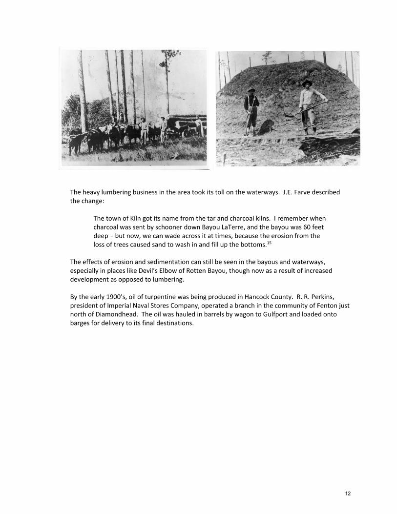
The heavy lumbering business in the area took its toll on the waterways. J.E. Farve described the change:
The town of Kiln got its name from the tar and charcoal kilns. I remember when charcoal was sent by schooner down Bayou LaTerre, and the bayou was 60 feet deep – but now, we can wade across it at times, because the erosion from the loss of trees caused sand to wash in and fill up the bottoms.15
The effects of erosion and sedimentation can still be seen in the bayous and waterways, especially in places like Devil’s Elbow of Rotten Bayou, though now as a result of increased development as opposed to lumbering. By the early 1900’s, oil of turpentine was being produced in Hancock County. R. R. Perkins, president of Imperial Naval Stores Company, operated a branch in the community of Fenton just north of Diamondhead. The oil was hauled in barrels by wagon to Gulfport and loaded onto barges for delivery to its final destinations.
12

The Great Depression saw the decline of the lumber industries in the area and the Prohibition spurred an easy transition to distilling alcohol. Father Henry McInerny stated:
With the proliferation of kilns for distilling turpentine and for curing lumber, it probably seemed fairly logical to experiment with distilling alcohol. In the days of prohibition, it made this option all the more lucrative. However, it seems that it was not until after the depression and the loss of the lumber and sawmill business here that, for many people, it was probably done out of necessity as much as anything. It has been told to me, by one who knows, that at the height of its popularity, there were probably up to 50 stills operating in these parts.16
Whiskey making was a big business in the area and saw large growth spurts after the Mississippi Prohibition Act was passed in 1908 and again after the National Prohibition Act was passed in 1918. Kiln liquor had a reputation for its quality and high alcohol content as far north as Milwaukee and there were tales of giant stills hidden under piles of sawdust from the area’s lumbering days.17
13

The Catholic church had a large presence in the Three Rivers Mission area and by the 1840’s there were three reported Catholic churches in the watershed. One was called St. Joseph and was located on Rotten Bayou and another was located on Kiln-Delisle Road between Kapalama Road and Fenton Road. A third church called St. Joseph Chapel was located on Fenton Road that remained until the 1980’s.18 St. Joseph’s Cemetery, also known as Rotten Bayou Cementary, is located just north of Diamondhead. The cemetery was said to be a burial place long before there were any marked graves. Early funeral processions came by boat through Jourdan River and Rotten Bayou before there were any roads in the area. The Moran (Morin) family owned the land in the early 1800’s before Francois Cuevas (descendent of Juan Cuevas of Cat Island) married Felicity Moran.19 The Cuevas’ later donated the 40-acre cemetery to Hancock County in 1893.20 By the mid-1960’s, Federal interstate highways were being constructed in stretches across the coast. Plans for Diamondhead, what was to be the largest residential/resort community in the south were announced in 1969. The project was named Diamondhead because it was on the highest ground on the Mississippi Gulf Coast and was to feature Hawaiian-style architecture and landscaping. The 6,500-acre property, formerly owned by the Gex family, was located north of St. Louis Bay with two miles of shoreline on the Bay and another nine miles on Rotten Bayou. The master plan, when fully completed, was expected to exceed $100,000,000 and include a shopping center, schools, churches and other amenities including a 36-hole golf course.21 As of the 2010 census, there were 8,425 people living in Diamondhead and on February 6, 2012, Diamondhead became Mississippi’s 111th city.
14

2.1.3 Current and Future Land Use
The watershed is primarily undeveloped (51.8%) and lower density, single family residential (43%). The remainder of the watershed is golf course (2.1%), agricultural (1.6%), commercial (1.4%) and multi-family residential (0.1%).22 See Figure 2. Only about 0.1% of land in Rotten Bayou Watershed is publically owned.
Figure 2: Current Land Use
Source: Land use data from Gulf Regional Planning Commission. Map by Gulf Coast Community Design Studio
15
In terms of opportunity for future development, there are currently 2,017 parcels considered “vacant and undeveloped,” though due to wetland and flood plain constraints not all of these parcels are likely to be suitable for development. There are some plans for additional commercial development in the City of Diamondhead and opportunities for more residential development, particularly single family, throughout the watershed that will likely impact stormwater runoff in the future. The increase in commercial land use could be about 4% in the watershed according to the jurisdictions’ comprehensive plans.23 Within Diamondhead there is approximately one square mile of remaining developable land.24 The planned increase in residential development is harder to determine because Harrison County does not distinguish between agriculture and rural single family residential in the future plan use component of their comprehensive plan.
2.2 Human Resources
2.2.1 Demographics
As of the 2010 Census, there were 25,619 people living in the watershed, of which 8,425 live in the city limits of Diamondhead. Of the total population, 90.3% are White, 4.5% are Black/African American, 2.5% are Hispanic/Latino(a), and 0.7% are Asian. According to the American Community Survey’s 2011-5 year estimates, 15.5% of the population is living below the poverty limit. This is fairly consistent with the national poverty rate (15.1%) and below the 20% threshold that is considered the rate of high poverty for rural areas and tipping point at which poverty will continue to grow in neighborhoods.252627 There are a total of 11,537 housing units within Rotten Bayou Watershed. Of the built housing units, 85.3% are occupied and 14.7% are vacant. This is a relatively high vacancy rate compared to the national vacancy rate (7.9%), but consistent with the vacancy rate for the three coastal counties (14.3%) and indicates that the population has still not recovered since Hurricane Katrina. The majority of the housing in the watershed is owner occupied (85.7%) which may be a positive factor in improving environmental stewardship in the watershed. 28
2.2.2 Municipal
Rotten Bayou Watershed is a multi-jurisdictional watershed. The watershed is almost perfectly divided in half between Hancock County to the west and Harrison County to the east. Mississippi’s newest city, Diamondhead, makes up the southwestern quadrant of the watershed. Further complicating bureaucracy in the watershed is the existence of the Diamondhead Country Club and Property Owners Association (DPOA) that maintains a level of control over platted residential property in Diamondhead. The DPOA is further discussed in Section 2.2.3.
Multiple water and sewer districts have jurisdiction in the area including Diamondhead Water and Sewer District, Hancock County Water and Sewer District, and the Harrison County Utility Authority. The complex and multi-jurisdictional nature of Rotten Bayou watershed presents a challenge for, but also a greater justification for planning and collaboration in the watershed around issues of water quality.
16

2.2.3 Civic Infrastructure
There are several civic organizations that are active in Rotten Bayou Watershed and important to current and future watershed protection strategies. These include, but are not limited to the Diamondhead Property Owners Association, Keep Diamondhead Beautiful, Diamondhead Garden Club, Rotary Club of Central Hancock County, Hancock and Harrison County Master Gardeners, Land Trust for the Mississippi Coastal Plain and the Mississippi State University Extension Service. Brief descriptions of each organization are included below.
Diamondhead Country Club and Property Owners Association
The Diamondhead Property Owners Association (DPOA) is a non-profit corporation tasked with managing and developing civic and recreational assets in the community of Diamondhead. The mission of the organization is to “protect and preserve the assets and amenities of the Diamondhead POA, to seek and implement programs for improvements that will enhance quality of life, and to provide sound competent governance and financial and operational management for all POA functions.” The POA is committed to serving all members and residents of the larger community. Currently, the POA owns and operates a country club with two restaurants and banquet services; two golf courses; three pools; tennis facilities; several parks and walking trails; a marina; and an airport. All amenities are open to and regularly used by the public at large though some require membership dues.
In addition to the main property owners association, the Devil's Elbow community within Diamondhead has a separate POA. Devil’s Elbow is a creole-designed, private community nestled along Rotten Bayou. Residents of Devil’s Elbow are strong advocates for preserving the natural habitat of Rotten Bayou and regularly enjoy boating, kayaking, fishing, and bird-watching.
Land Trust for the Mississippi Coastal Plain
The Land Trust for the Mississippi Coastal Plain (LTMCP) was founded in 2000 and works in the six coastal counties of Mississippi. The organization strives to conserve, promote and protect open spaces and green places of ecological, cultural or scenic significance in the counties of the Mississippi Coastal Plain. LTMCP is accredited by the Land Trust Accreditation Commission, an independent program of the Land Trust Alliance, and has worked with landowners and local authorities to protect over 8000 acres of valuable wetlands and environmentally significant land in the region.
Keep Diamondhead Beautiful
Keep Diamondhead Beautiful was established in December 2013 by resolution of the City of Diamondhead. The Keep Diamondhead Beautiful Committee focuses on beautifying the City of Diamondhead, involving the community in the beautification efforts, continuing to support the sense of pride that already exists in the City of Diamondhead by encouraging the citizens and the administration to provide a clean and litter free environment, by helping to develop landscaping and maintenance plans and projects for the safety and beauty of the City of Diamondhead.
Diamondhead Garden Club
The Diamondhead Garden Club has been an active community partner since 1972. Members have worked to landscape many areas of the community and hold monthly meetings featuring
17

speakers that cover topics ranging from birds and plants to conservation and best practices. The Garden Club sponsors an annual flower show that also features educational exhibits. These Educational Exhibits always focus on information that educates the public about the environmental and beautification goals of the National Garden Clubs, Inc.
Mississippi State University Extension Service
The Mississippi State University Extension Service provides research-based information, educational programs, and technology transfer focused on issues and needs of the people of Mississippi, enabling them to make informed decisions about their economic, social, and cultural well-being. Core programs include agriculture and natural resources, family and consumer education, enterprise and community resource development and 4-H youth development. The MSU Extension also coordinates the Master Gardener Volunteer program. Through this program, individuals are trained and certified in consumer horticulture and related areas. The program allows the local Extension Service to reach a larger gardening audience. Continuing education is offered to encourage long-term commitments and most certified Master Gardeners serve five to seven years. Master Gardener programs are active in both Hancock and Harrison Counties.
Rotary Club of Central Hancock County
Rotary is an organization of business and professional persons united worldwide who provide humanitarian service, encourage high ethical standards in all vocations, and help build goodwill and peace in the world. The Rotary Club of Central Hancock County has several key focus areas including clean water and participates with other civic organizations in the Mississippi Coastal Cleanup, watershed cleanup activities and community gardening.
2.3 Physical Setting
2.3.1 Soils and Geology
The soil and geology of a drainage area make up the hydrogeologic setting of a watershed. The type and distribution of the materials that affect the surface and substrate are important to understand in watershed planning because they greatly influence the response of surface water both to precipitation and contaminants. In addition, the hydrogeologic conditions influence which Best Management Practices are most suitable for a given area. A good understanding of the soil types and geologic characteristics of a watershed will both improve the effectiveness and efficiency of strategies recommended and implemented through a watershed implementation plan. The geological makeup of the Rotten Bayou Watershed, and most of the Mississippi Gulf Coast, is characterized by sedimentary formations of estuarine and deltaic origin ranging from the late Oligocene to the Holocene epochs.29 See Figure 3. According to MDEQ’s Office of Geology, there is still a lot of uncertainty around the geology in Gulf region extending from east Texas to the Florida line and the last published study was in 1944.30
18
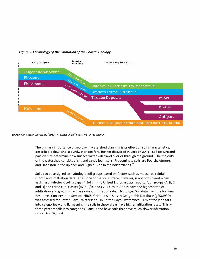
Figure 3: Chronology of the Formation of the Coastal Geology
Source: Ohio State University. (2012). Mississippi Gulf Coast Water Assessment.
The primary importance of geology in watershed planning is its effect on soil characteristics, described below, and groundwater aquifers, further discussed in Section 2.4.1. Soil texture and particle size determine how surface water will travel over or through the ground. The majority of the watershed consists of silt and sandy loam soils. Predominate soils are Poarch, Atmore, and Harleston in the uplands and Bigbee-Bibb in the bottomlands.31 Soils can be assigned to hydrologic soil groups based on factors such as measured rainfall, runoff, and infiltration data. The slope of the soil surface, however, is not considered when assigning hydrologic soil groups.32 Soils in the United States are assigned to four groups (A, B, C, and D) and three dual classes (A/D, B/D, and C/D). Group A soils have the highest rate of infiltration and group D has the slowest infiltration rate. Hydrologic Soil data from the National Resources Conservation Service (NRCS) Gridded Soil Survey Geographic Database (gSSURGO) was assessed for Rotten Bayou Watershed. In Rotten Bayou watershed, 56% of the land falls into categories A and B, meaning the soils in these areas have higher infiltration rates. Thirty-three percent falls into categories C and D and have soils that have much slower infiltration rates. See Figure 4.
19

Figure 4: Dominant Hydrologic Soil Groups Rotten Bayou Watershed
Source: Gridded Soil Survey Geographic (gSSURGO) Database for Mississippi. United States Department of Agriculture, Natural Resources Conservation Service. Available online at http://datagateway.nrcs.usda.gov/. [Accessed 11/25/2014]. Map by NOAA’s National Coastal Data Development Center.
The types and location of soils often determine what managerial, structural or vegetative activities are feasible. Areas that contain soils with high infiltration rates are directly responsible for infiltrating precipitation and feeding the upper reaches of the watershed with groundwater inflow that function to moderate flows and maintain a cool water temperature regime. Protection of these areas is extremely important to maintain existing high water quality. These areas are also are more suitable for the installation of BMPs that function to increase infiltration. On the other hand, areas that contain soils with slow infiltration rates tend to be more susceptible to erosion if not properly managed and vegetated. The areas with poor
20

drainage are also not well-suited for septic systems. Section 2.4.6 further explores the extent of nonfunctioning septic systems in Rotten Bayou Watershed. Several of the areas identified as having poor drainage do appear to coincide with some of the nonfunctioning septic systems identified, especially in Harrison County.
2.3.2 Ecoregion
Ecoregions are generally defined as an area with a relative homogeneous ecosystem. Geographic areas are assigned to different ecoregions based on biotic and abiotic characteristics including geology, physiography, vegetation, climate, soils, land use, wildlife and hydrology.33 Ecoregions are intended to provide a geographic area for ecosystem assessment, monitoring and management.34 Traditionally, ecoregions and watersheds have been treated as two separate frameworks for environmental assessment and management, but more recently are being used in coordination with one another:
Although ecoregions and watersheds are intended for different purposes, they can be complementary. Ecoregions provide the spatial framework within which the quality and quantity of environmental resources, and ecosystems in general, can be expected to exhibit a particular pattern. Where watersheds are relevant and can be defined, they are necessary for studying the relationships of natural and anthropogenic phenomena with water quality, as well as for providing the spatial unit for reference areas within ecoregions at all scales.35
Rotten Bayou Watershed extends into two ecoregions. The northern portion of the watershed is in the Southeastern Plains ecoregion and the southern portion of the watershed is in the Southern Coastal Plains ecoregion. While there is a distinct divide between the two ecoregions for mapping and analysis purposes, ecoregion boundaries rarely form abrupt edges.36 The Southeastern Plains are a mix of cropland, pasture, woodland, and forest. Natural vegetation consisted predominantly of longleaf pine, with smaller areas of oak-hickory-pine and Southern mixed forest. Elevations and relief are greater than in the Southern Coastal Plain, but generally less than in much of the Piedmont. Streams in this area are generally lower-gradient and have sandy bottoms.37
The Southern Coastal Plain consists of mostly flat plains, but also includes barrier islands, coastal lagoons, marshes, and swampy lowlands along the Gulf and Atlantic coasts. Forests historically consisted of longleaf pine, slash pine, pond pine, beech, sweetgum, southern magnolia, white oak, and laurel oak, but is now mostly slash and loblolly pine with oak-gum-cypress forest in some low lying areas, citrus groves in Florida, pasture for beef cattle, and urban areas.38
2.3.3 Wetlands
Wetlands are critical to protecting water quality and moderating water quantity. Some of these “wetland services” that protect water quality and quantity include providing erosion control, flood protection, filtration, critical habitat and carbon sequestration. Coastal wetland losses occur as a result of both human activity and natural processes. Human activities such as urban development can remove wetlands, harden shorelines and change overall hydrology. Natural processes such as erosion and inundation from sea level rise and storms can also affect
21

wetlands.39 Following the State’s passage of the Coastal Wetland Protection Act, wetland loss due to development fell dramatically while coastal erosion became the major contributor of wetland loss.40
Rotten Bayou watershed is comprised of a mix of wetland environments including estuarine, freshwater and riverine, the most common being freshwater forested/scrub wetlands that extend throughout the reaches of the watershed. Overall, about 20% of the land area in the watershed is classified as “wetlands” as defined by the Mississippi Department of Marine Resources (MDMR). See Figure 5. Figure 5: Wetlands in Rotten Bayou Watershed
Source: Map and analysis by the Mississippi Department of Marine Resources Coastal Preserves Program (2014).
Wetlands in Rotten Bayou watershed are under the jurisdiction of MDMR’s Coastal Program according to Section 57-15-6 of the Mississippi Code of 1972. Rotten Bayou watershed is part of
22

the Mississippi Coastal Zone which includes Hancock, Harrison and Jackson Counties. Implementation of the Coastal Program is the primary responsibility of the Office of Coastal Zone Management and includes administering the Coastal Preserves Program, Wetlands Permitting, and other special projects. Wetland activities that are regulated include:
Dredging, excavating or removing of soil, mud, sand, gravel, flora, fauna, or aggregate of any kind from any coastal wetlands; dumping, filling or depositing of any soil, stones, sand, gravel, mud aggregate or of any kind or garbage, either directly or indirectly, on or in any coastal wetlands; killing or materially damaging any flora or fauna on or in any coastal wetlands; and the erection on coastal wetlands of structures which materially affect the ebb and flow of the tide; and the erection of any structure on suitable sites for water dependent industry. The use of the term “indirectly” in this definition covers the possibility of activities located outside of coastal wetlands which cause dumping, filling, or depositing in coastal wetlands.41
Applications for wetlands activities in the Mississippi Coastal Zone are submitted through MDMR, but also reviewed by the U.S. Army Corps of Engineers (USACE) under the Memorandum of Agreement with the Mobile and Vicksburg Districts of the USACE.42
2.3.4 Climate and Climate Change
Rotten Bayou Watershed, and Mississippi, in general, are located in a humid subtropical climate region, characterized by temperate winters; long, hot summers; and rainfall that is fairly evenly distributed through the year. The region, however, is subject to periods of both drought and flood, and determining "average" conditions is challenging. Prevailing southerly winds provide moisture for high humidity and potential discomfort from May through September. Locally violent and destructive thunderstorms are a threat on an average of about 60 days each year. Eight hurricanes have struck Mississippi's coast since 1895, and tornadoes are a particular danger, especially during the spring season.43
Normal mean annual temperatures are 68F along the coast. Low temperatures have dropped to 16F below zero while high temperatures exceed 90F over 100 days each year. Temperatures routinely exceed 100F at many places in the state each year and drop to zero or lower an average of once in five years in the state. Normal precipitation ranges from about 50 to 65 inches across the state from north to south.44
Climate change is likely to affect several processes that will impact watershed dynamics in coastal Mississippi and Rotten Bayou watershed including sea level rise and frequency and duration of rainfall events. There are various estimates of sea level rise resulting from climate change, but even according to the most conservative predictions, substantial flooding of coastal area appears to be likely. There is also a limited amount of local and regional sea level rise data available for the Mississippi Gulf Coast. Based on available data, Mississippi expects a minimum sea level rise of approximately 10 inches by the year 2100. However, gaps in the data available and a lack of long term historical trends may affect the accuracy of this prediction.45 Sea level rise is likely to have a significant impact on wetlands in the area:
A rise in sea level inundates the coastal vegetated lands, converting them into areas of open water and resulting in a loss of wetland functions. Although new wetlands may be
23

created further towards the inland if the coastal topography is ideal (i.e., in the presence of gradually increasing slope), whether or not they can make up the loss due to sea level rise largely depends on the extent of land development on the newly flooded area, as well as the rate at which the replacing wetland ecosystem functions can be fully established.46
NOAA’s Digital Coast Sea Level Rise and Coastal Flooding Impacts Viewer is a tool for visualizing impacts of sea level rise from one foot to five feet. When comparing the impacts of sea level rise in Rotten Bayou Watershed (See Figure 6) to existing wetland habitat shown in Figure 5 it is apparent that a substantial amount of wetland habitat in the watershed could be compromised by sea level rise. This is important in terms of planning to protect inland wetlands and allowing for buffers around waterways wherever possible.
24
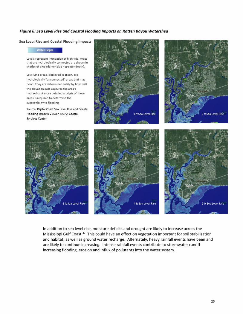
Figure 6: Sea Level Rise and Coastal Flooding Impacts on Rotten Bayou Watershed
In addition to sea level rise, moisture deficits and drought are likely to increase across the Mississippi Gulf Coast.47 This could have an effect on vegetation important for soil stabilization and habitat, as well as ground water recharge. Alternately, heavy rainfall events have been and are likely to continue increasing. Intense rainfall events contribute to stormwater runoff increasing flooding, erosion and influx of pollutants into the water system.
25

2.3.5 Conservation Mapping
In 2010 the Land Trust for the Mississippi Coastal Plain and consultant, CDM Smith, undertook a project known as Conservation Legacy to develop a toolkit for conserving land in a more strategic manner in the six coastal counties of Mississippi. One of the products was a Map of Potential Conservation Lands that is a model of the suitability of land for conservation based on ranked environmental and land use conditions including wetlands, hydrological soil groups, flood zones, elevation/slope, upland forest and important ecosystems.48
Areas that are in Rotten Bayou watershed and currently undeveloped were identified as being relatively high priority (6/7/8) areas in terms of conservation and should be considered in planning and management strategies for Rotten Bayou Watershed. See Figure 7.
Figure 7: Conservation Priority Areas in Rotten Bayou Watershed.
Source: Land Trust for the Mississippi Coastal Plain. Conservation Legacy: Potential Conservation Lands Map. <http://gis.co.harrison.ms.us/landtrust/>. Accessed 4 December 2014.
26

2.4 Water Resources
2.4.1 Groundwater
There are 16 major aquifers and various minor aquifers throughout Mississippi. The groundwater resources found in these aquifers supplies over 90% of Mississippi’s drinking water supply. In the coastal counties, drinking water and potable water is mainly supplied through the Grand Gulf Aquifer System which includes, in ascending order, the Catahoula, Hattiesburg, Pascagoula and Graham Ferry aquifers.49
There are four public wells located within Rotten Bayou Watershed (See Table 2). It is unclear how much of the population is supplied by private well, although it is estimated that 38% of the Gulf region’s population is serviced by private wells.50 The earliest record of a water well within the watershed is for a domestic well drilled in 1925. Through the 1980’s the number of wells drilled remained steady, but have since declined.51
Table 2: Public Wells in Rotten Bayou Watershed
PERMIT # OWNER_NAME AQUIFER DATE DRILLED MS-GW-12542 DIAMONDHEAD WATER AND SEWER DISTRICT UPPER PASCAGOULA 9/1/1971
MS-GW-14652 DIAMONDHEAD WATER AND SEWER DISTRICT LOWER GRAHAM FERRY 10/1/1993
MS-GW-16560 DIAMONDHEAD WATER AND SEWER DISTRICT LOWER PASCAGOULA 1/26/2009 MS-GW-16561 DIAMONDHEAD WATER AND SEWER DISTRICT LOWER PASCAGOULA 4/14/2009
Source: Mississippi Department of Environmental Quality, Office of Land and Water Resources. 2014
The wells in Rotten Bayou are supplied by the Graham Ferry and Pascagoula aquifers. There are relatively few notable concerns related to water quantity and quality associated with these aquifers. The Graham Ferry and Pascagoula aquifers tend to be higher in iron and manganese which can affect the flavor and color of the water.52 The Mississippi Department of Health monitors the water quality for the public water supply wells and all public wells are currently compliant for volatile organic chemicals, synthetic organic chemicals and nitrate concentration.53
The Graham Ferry and Pascagoula aquifers are almost entirely fresh water, but potentially have more contact with surface waters from the Gulf of Mexico or estuarine waters in coastal areas. The danger of saltwater intrusion into coastal aquifers is an important concern in the watershed. A study done by MDEQ in 2002 found that while salt concentrations in the well water in the area are naturally higher, they have not increased at a rate that would provide evidence of saltwater intrusion. The study also found that saltwater intrusion is unlikely due to extraction of groundwater in the deeper confined aquifers.54 The deeper sands of the aquifer system are recharged at their outcrop, significantly north of Rotten Bayou Watershed. The shallower areas of the system, however, can by impacted directly by actions or development within the watershed.55
27

2.4.2 Water Conservation
The main factor affecting groundwater quantity in the area is the amount of water being pumped from the aquifers. MDEQ’s Office of Land and Water Resources considers the population sparse and the groundwater abundant in Rotten Bayou Watershed. They also acknowledge the existence of many smaller aquifers that could be available for use, but have never been produced due to lack of demand.56 The Gulf Region Water and Wastewater Plan, however, notes that Hancock and Harrison counties all project “steady increases in water demands that cannot be met by current water supply, treatment, and distribution infrastructure.” The improved infrastructure is being planned and implemented based on the projected 2025 demand. 57
At the present time no effluent water is being utilized for irrigation purposes. There are, however, several opportunities to use effluent for irrigation especially in Diamondhead including on the existing golf courses and new ball fields being constructed by the Diamondhead Property Owners Association off Noma Drive.58
2.4.3 Access and Recreation
The coast and its upland waterways provide the opportunity for a wide range of recreational activities. In a public opinion survey conducted in the Southern Mississippi Planning and Development District on 65 outdoor recreational activities, nine out of the 45 most popular were water related. The most popular activities include fishing, canoeing, kayaking, rafting, and tubing.59 Rotten Bayou, however, has no designated public access sites where people can go to recreate on or near the bayou. Hancock County, in general has significantly fewer water-related access sites as compared to the other coastal counties in Mississippi (See Table 3). Lack of access to Rotten Bayou and its tributaries, is a likely contributor to an existing disconnect between residents of and visitors to Rotten Bayou Watershed and the health of the local waterways.
Table 3: Public Water Access Sites and Amenities of Mississippi Coastal Counties
Source: Ohio State University. (2012). Mississippi Gulf Coast Water Assessment. Water Assessment. Pg 41.
28

Currently the only way the public can access Rotten Bayou is via the boat launch at Diamondhead Marina and by traveling a considerable distance up the Jourdan River into Rotten Bayou. While there is fairly limited opportunity to offer public access sites along Rotten Bayou as it is primarily bordered by private, residential land, there are, however, several options that are being explored through this planning process. Increasing the number of water access points along Rotten Bayou and in Hancock County, in general, would be beneficial along several lines. First, when coupled with educational signage, these access sites could serve to connect people with their waterways and increase environmental stewardship. In addition, nature-based recreation is a growing market in south Mississippi and responding to this growing demand would likely prove beneficial both in terms of economic development and property values.
2.4.4 Wildlife and Fisheries
The Watersheds support a broad diversity of wildlife. Mississippi National Heritage Inventory keeps a database of critical species known as species of "special concern". Several of the species identified as being of “special concern” and possibly in Hancock and/or Harrison Counties are listed as threatened (See Appendix B: Mississippi National Heritage Inventory). After reviewing the list, the U.S. Fish and Wildlife Service office in Hancock County advised that the Gulf Sturgeon, listed “threatened” nationally and “endangered” statewide, is not present in Rotten Bayou. They added that there is a possibility that Gopher Tortoise, listed “threatened” nationally and “endangered” statewide, is present in the upland areas of the watershed and that the Pearl Darter, listed as a “candidate” nationally and “endangered” statewide, is present in Rotten Bayou, although there have not been any reported sightings.60
2.4.5 Designated Use Classifications and Water Quality Standards
Rotten Bayou’s beneficial use is designated as “Fish and Wildlife” and is intended for fishing and for maintaining waterways for the support of fish, aquatic life, and wildlife.61 Waters that meet the Fish and Wildlife Criteria are also considered suitable for secondary contact recreation defined as “incidental contact with the water during activities such as wading, fishing, and boating, that are not likely to result in full body immersion”.62
Applicable water quality standards included DO concentrations maintained at a daily average of not less than 5.0 milligrams per liter (mg/l) with an instantaneous minimum of not less than 4.0 mg/l.63 Water quality standard for nutrients for tributaries of the St. Louis Bay are further defined as follows:
Waters shall be free from materials attributable to municipal, industrial, agricultural or other discharges producing color, odor, taste, total suspended or dissolved solids, sediment, turbidity, or other conditions in such degree as to create a nuisance, render the waters injurious to public health, recreation or to aquatic life and wildlife or adversely affect the palatability of fish, aesthetic quality, or impair the water for any designated use.64
In addition to the thresholds adopted by MDEQ and directly applicable to the Rotten Bayou Watershed Implementation Plan, there are several other proposed thresholds that are considered in this planning work (See Table 4). The State of Mississippi, for example, has
29

developed draft numeric nutrient thresholds for non-tidal streams and rivers to protect aquatic life uses in Mississippi. The recommended thresholds for TN in southeast Mississippi rivers and streams ranges from 0.31 to 0.68 mg/l, depending on the approach. The proposed threshold for TP ranges from 0.01 to 0.05 mg/l, depending on the approach.65
In addition, the Gulf of Mexico Alliance (GOMA), under the direction of MDEQ, completed a study of sources and effects of nutrients as a basis for protection of estuarine and near-coastal waters for St. Louis Bay.66 Based on empirical and mechanistic modeling results, the preliminary annual geometric mean threshold recommendations are 0.6 to 0.8 mg/l for TN and 0.06 to 0.08 mg/l for TP.
Table 4: Various Targets and Thresholds for Tributaries to St. Louis Bay and for St. Louis Bay
Source: Anchor QEA, LLC. Prepared for Land Trust of the Mississippi Coastal Plain. (2014). Rotten Bayou Water Quality Assessment. Pg. 3.
It is important to note that monitoring and water quality standards for “Fish and Wildlife” are not intended to support contact recreation such as swimming and water skiing. While there are currently no public access sites on Rotten Bayou, there are private land owners that have docks directly on Rotten Bayou and report regularly engaging in what would be considered contact recreation in the waterway. While the number of residential lots on Rotten Bayou appears to be relatively few, anecdotal evidence purports that more people might actually be swimming in the bayou than suggested by the number of lots. In a survey of participants in the Watershed Harmony program through the Hancock County Library System’s Summer Reading Program, 10 out of 30 respondents reported that their family currently swims in Rotten Bayou and 19 said they would like to swim in Rotten Bayou if given the opportunity. Based on existing interest and concerns of residents around water quality suitability in Rotten Bayou for recreational activities such as swimming, MDEQ has been monitoring pathogens at two locations in Rotten Bayou as part of the Rotten Bayou watershed planning effort. Results are further discussed in Section 2.4.6.
30

2.4.6 Current Status of Water Bodies
Nutrients
USGS has been monitoring data the following four gauges within Rotten Bayou watershed since 2012. The first stage of monitoring was completed in 2014. Monitoring has since been suspended to allow for BMP installation. Once the grant-funded BMPs are installed, MDEQ and USGS will re-instate monitoring activities in an effort to show water quality improvements. See Figure 8.
• 02481661 – Tributary to Bayou LaSalle near Vidalia, Mississippi • 02481663 – Rotten Bayou near Fenton, Mississippi • 0248166310 – Mill Creek at Fenton, Mississippi • 0248166590 – Rotten Bayou Tributary No. 1 at Diamondhead, Mississippi
Figure 8: Location of USGS Gauges in Rotten Bayou Watershed
Source: Anchor QEA, LLC. Prepared for Land Trust of the Mississippi Coastal Plain. (2014). Rotten Bayou Water Quality Assessment. Figure 1.
31

Analysis of the data, however, is not projected to be completed until 2016. The Rotten Bayou Watershed Implantation Plan to address the TMDL in Rotten Bayou is being funded through September 2015. As a result of this mismatch in project timing, Land Trust for the Mississippi Coastal Plain procured the services of Anchor QEA to assess the draft and provisional data from USGS for use in the Watershed Implementation Plan.
As part of their assessment, Anchor QEA downloaded flow and TN/TP concentration data from the USGS website on September and October 2014 and compared the concentrations to all three thresholds discussed in Section 2.4.5. It is important to note that three of the gauges are freshwater (i.e. non-tidal), while the gauge in Diamondhead is tidally influenced. Because of this, it is impossible to discern the influence of Rotten Bayou Watershed from St. Louis Bay on nutrient concentrations detected at this gauge.67
Few TN and TP measurements from 2012 to 2014 exceeded the nutrient TMDL thresholds at the freshwater gauges (Figures 9 and 10). For TN, none of the measurements exceeded the nutrient TMDL threshold with the exception of one measurement on July 18, 2012, at 4:15 pm at 0248166310 Mill Creek at Fenton. For TP, 8% and 4% of samples at 02481661 Tributary to Bayou LaSalle near Vidalia and at 0248166310 Mill Creek at Fenton, respectively, exceeded the TMDL threshold; these exceedances appear to have been during storm events. Only one sample taken at 02481663 Rotten Bayou near Fenton exceeded the TP TMDL threshold; this sample was collected on July 12, 2012.68
Figure 9: Temporal of Total Nitrogen Concentration at Three Freshwater Gauges near Rotten Bayou
Source: Anchor QEA, LLC. Prepared for Land Trust of the Mississippi Coastal Plain. (2014). Rotten Bayou Water Quality Assessment. Figure 2.
32

Figure 10: Temporal of Total Phosphorus Concentration at Three Freshwater Gauges near Rotten Bayou
Source: Anchor QEA, LLC. Prepared for Land Trust of the Mississippi Coastal Plain. (2014). Rotten Bayou Water Quality Assessment. Figure 3.
Some TN and TP concentrations from the freshwater gauges were higher than the draft revised stream nutrient thresholds for southeast Mississippi. Thirteen percent and 7% of the samples exceeded the TN threshold at 02481661 Tributary to Bayou LaSalle near Vidalia and at 0248166310 Mill Creek at Fenton, respectively. These samples, however, appear to have been taken during storm events as multiple samples were taken on a single day. No TN measurement at 02481663 Rotten Bayou near Fenton exceeded the threshold. A similar pattern of exceedances is observed for TP data.69
The St. Louis Bay thresholds were developed based on tidally influenced monitoring data in St. Louis Bay. Table 5 summarizes annual geometric means of TN and TP for the tidal gauge near Rotten Bayou from 2012 to 2014. At this gauge, the annual geometric means exceeded the St. Louis Bay thresholds for both TN and TP in 2013 and 2014.70
33

Table 5: Annual Geometric Means at the Tidal Gauge at Diamondhead
Source: Anchor QEA, LLC. (2014). Rotten Bayou Water Quality Assessment.
Based on analysis of the best available data, it was concluded that the TN and TP concentrations measured at the three freshwater gauges in Rotten Bayou Watershed are generally below or near the various Mississippi nutrient threshold concentrations with the exception of data collected during a few storm events in 2012 and 2014. The TN and TP concentrations from the tidal gauge in Diamondhead exceeded the thresholds in two of the three monitoring years.71 Limitations of the data analyzed for the Rotten Bayou Watershed Implementation Plan are discussed in the full report. See Appendix C: Rotten Bayou Water Quality Assessment. Based on these preliminary findings the report recommended focusing BMPs for controlling runoff and stormwater in the drainage areas upland of the Diamondhead and Mill Creek gauges.72
Pathogens
At the request of the Rotten Bayou Watershed Partnership’s Steering Committee and learning that Rotten Bayou is being used for primary contact recreation including swimming and jet skiing, MDEQ began testing for pathogens including Fecal Coliform and E. Coli in the fall of 2014. Two locations were chosen for testing. The first location was the bridge at Rotten Bayou and Kiln-Delisle Road, just north of the confluence with Mill Creek. This site was chosen to give some indication of the impacts of nonfunctioning septic system concentrations in western Harrison County (See Figure 11). This section of Rotten Bayou is non-tidal. The second location was a private pier about three miles up Rotten Bayou. This section of the bayou is tidal, but is one of the main areas where residents are swimming.
The first set of testing was done between September 22 and October 8, 2014. This was during the “non-contact” recreational season when people are less likely to be coming in direct contact with the water. The second set of testing was done between March 18 and April 7, 2015; the “contact” recreational season when people are more likely to be in direct contact with the water. As described in Section 2.4.5, Rotten Bayou currently has a “Fish and Wildlife” classification. For this classification, the allowable concentrations of pathogens are a geomean of 200 colonies/100 ml for the contact season and 2000 colonies/100 ml for the non-contact
34
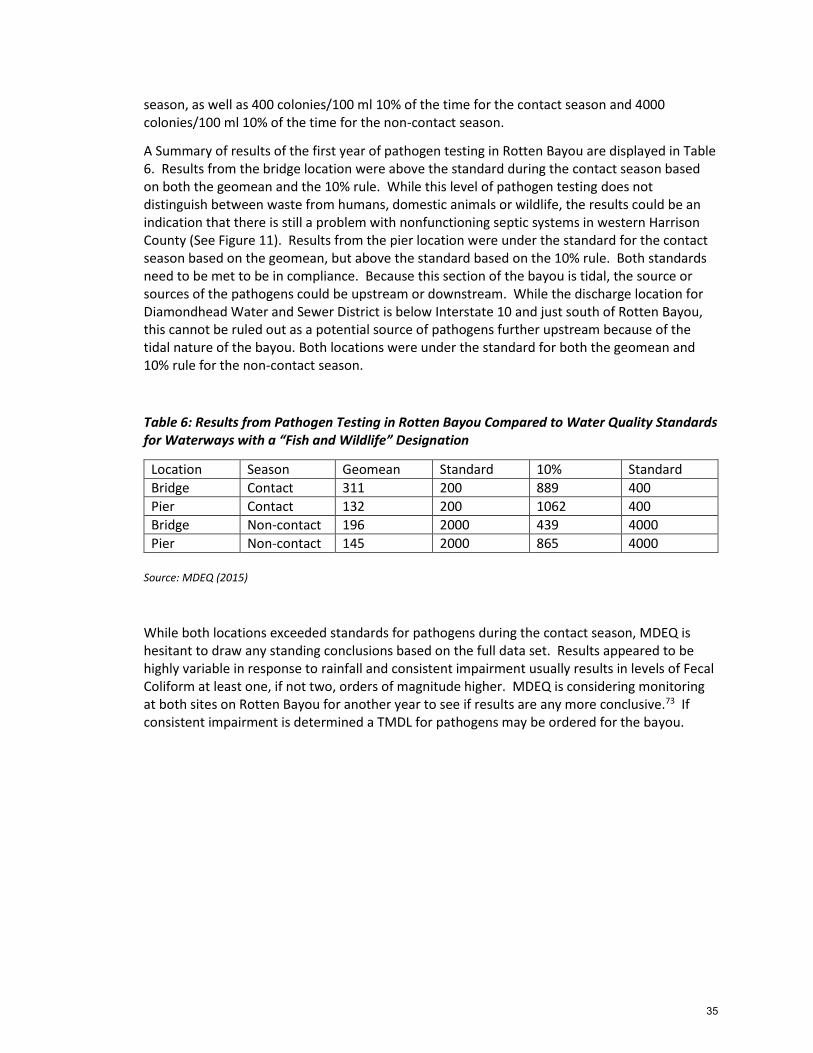
season, as well as 400 colonies/100 ml 10% of the time for the contact season and 4000 colonies/100 ml 10% of the time for the non-contact season.
A Summary of results of the first year of pathogen testing in Rotten Bayou are displayed in Table 6. Results from the bridge location were above the standard during the contact season based on both the geomean and the 10% rule. While this level of pathogen testing does not distinguish between waste from humans, domestic animals or wildlife, the results could be an indication that there is still a problem with nonfunctioning septic systems in western Harrison County (See Figure 11). Results from the pier location were under the standard for the contact season based on the geomean, but above the standard based on the 10% rule. Both standards need to be met to be in compliance. Because this section of the bayou is tidal, the source or sources of the pathogens could be upstream or downstream. While the discharge location for Diamondhead Water and Sewer District is below Interstate 10 and just south of Rotten Bayou, this cannot be ruled out as a potential source of pathogens further upstream because of the tidal nature of the bayou. Both locations were under the standard for both the geomean and 10% rule for the non-contact season.
Table 6: Results from Pathogen Testing in Rotten Bayou Compared to Water Quality Standards for Waterways with a “Fish and Wildlife” Designation
Location Season Geomean Standard 10% Standard
Bridge Contact 311 200 889 400
Pier Contact 132 200 1062 400
Bridge Non-contact 196 2000 439 4000
Pier Non-contact 145 2000 865 4000
Source: MDEQ (2015)
While both locations exceeded standards for pathogens during the contact season, MDEQ is hesitant to draw any standing conclusions based on the full data set. Results appeared to be highly variable in response to rainfall and consistent impairment usually results in levels of Fecal Coliform at least one, if not two, orders of magnitude higher. MDEQ is considering monitoring at both sites on Rotten Bayou for another year to see if results are any more conclusive.73 If consistent impairment is determined a TMDL for pathogens may be ordered for the bayou.
35

Figure 11: Nonfunctioning Septic Systems in Rotten Bayou Watershed
36

Erosion/sedimentation
Erosion and sedimentation appear to be major stressors affecting water quality in Rotten Bayou. While no streambank erosion rates are available for the watershed, several smaller engineering studies have been done that cite erosion and sedimentation as primary contributors to reductions in hydraulic capacity. Of particular significance is a study done by Compton Engineering in 2012 detailing erosion and sedimentation in the western portion of Diamondhead that drains into Devil’s Elbow, an oxbow feature of Rotten Bayou. The report notes that “In recent years Devil’s Elbow has filled with sediment downstream of the discharge point of the primary drainage ditch for western Diamondhead and investigation indicates that it was cleaning and clearing work conducted on this drainage ditch (post Hurricane Katrina) that caused erosion along the ditch and down-gradient deposition to occur.”74 The report documents specific source of erosion and suggestions for preventing, treating and controlling this type of nonpoint source pollution. In addition to areas immediately draining to Devil’s Elbow, many other areas through Diamondhead and Hancock and Harrison Counties are susceptible to erosion and contributing to sedimentation in the watershed. See Figure 12.
Figure 12: Erosion in Rotten Bayou Watershed
Source: Kelsey Johnson. Photos taken between March and November 2014
37

2.4.7 Sources of Pollutions
Currently there are no municipal or industrial facilities within the watershed that are permitted under the National Pollutant Discharge Elimination System. As such, most of the pollution noted above can be attributed to nonpoint sources. The Diamondhead Water and Sewer District does have a permitted discharge location downstream of Rotten Bayou and north of Interstate 10. Due to the tidal influence into Rotten Bayou the effects of this discharge should be more closely connected with planning in the watershed in the future.
Nutrients such as nitrogen and phosphorus often come from fertilizers and pesticides used in agriculture and on residential lawns and gardens. According to the Mississippi State University Extension Service, there are relatively few agriculture practices and no commercial row crop ventures that would require the most use of fertilizers and pesticides within the watershed.75 This seems to be supported by the relatively low TN and TP concentrations from the gauges near Vidalia and Fenton that respond to water draining from the upper and most rural parts of the watershed. TN and TP concentrations are higher at the Diamondhead and Mill Creek gauges that includes more dense residential and some commercial land uses, as well as two golf courses. Home pesticide and fertilizer use, as well as use for golf course maintenance are more likely to be significant contributors to nutrient loads in Rotten Bayou. Again, it is important to note that the Diamondhead gauge is tidally influenced and so it is currently not clear what nutrients are coming from development and the golf course versus the St. Louis Bay.
Pathogens such as Fecal Coliform and E. Coli can come from waste from humans from failing septic systems or discharge from sewer treatment plants, domestic animal waste such as from pets or livestock, or wildlife. Basic levels of testing do not provide enough data to determine the specific source, however additional testing can be done that will give a better indication of where the pathogens are coming from. If after further testing pathogens are determined to be a significant problem in Rotten Bayou, more fine-tuned testing to determine sources may be warranted. Regardless, potential sources such as concentrations of reported nonfunctioning septic in western Harrison County, discharge from Diamondhead Water and Sewer District and waste from pets and livestock that is not properly disposed of or controlled should be addressed.
Various activities throughout the watershed seem to be intensifying erosion and sedimentation. New residential and commercial construction that exposes soil without adequately managing for these changes both during and after construction can have a significant impact on the hydrology downstream. Most of the stormwater system in Rotten Bayou watershed utilizes swales and ditches as opposed to drains and pipes. Drainage swales can be much better for water quality when properly maintained because they allow for infiltration and can help slow the flow of water. However, when these ditches are cleared or cleaned in ways that remove vegetation and expose soils, they become sources of sediments that end up in the waterways. The use of recreational vehicles such as ATVs near waterways is a popular pasttime on the coast. When soils are disturbed near waterways and trails are not properly reinforced excess sediment can end up in the waterways hindering flow, navigability and critical habitat. An example of this is on the utility easement in Diamondhead that abuts Rotten Bayou off Bayou Drive just south of the confluence with Bayou La Terre.
38
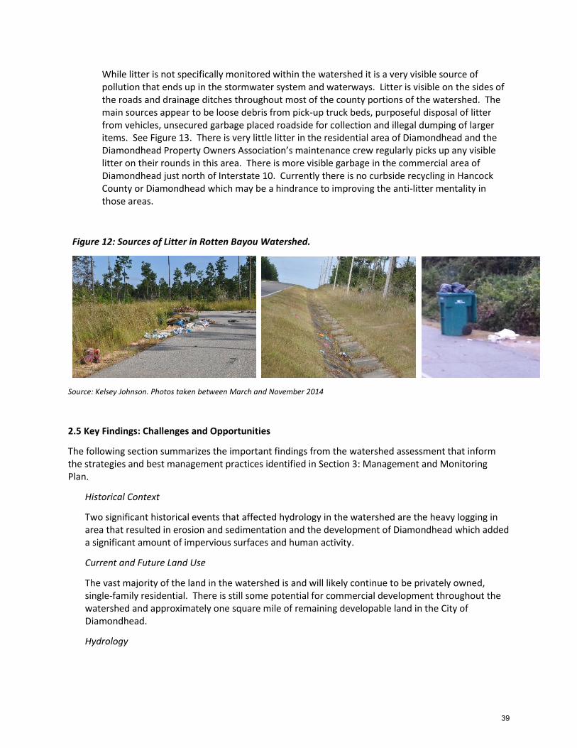
While litter is not specifically monitored within the watershed it is a very visible source of pollution that ends up in the stormwater system and waterways. Litter is visible on the sides of the roads and drainage ditches throughout most of the county portions of the watershed. The main sources appear to be loose debris from pick-up truck beds, purposeful disposal of litter from vehicles, unsecured garbage placed roadside for collection and illegal dumping of larger items. See Figure 13. There is very little litter in the residential area of Diamondhead and the Diamondhead Property Owners Association’s maintenance crew regularly picks up any visible litter on their rounds in this area. There is more visible garbage in the commercial area of Diamondhead just north of Interstate 10. Currently there is no curbside recycling in Hancock County or Diamondhead which may be a hindrance to improving the anti-litter mentality in those areas.
Figure 12: Sources of Litter in Rotten Bayou Watershed.
Source: Kelsey Johnson. Photos taken between March and November 2014
2.5 Key Findings: Challenges and Opportunities
The following section summarizes the important findings from the watershed assessment that inform the strategies and best management practices identified in Section 3: Management and Monitoring Plan.
Historical Context
Two significant historical events that affected hydrology in the watershed are the heavy logging in area that resulted in erosion and sedimentation and the development of Diamondhead which added a significant amount of impervious surfaces and human activity.
Current and Future Land Use
The vast majority of the land in the watershed is and will likely continue to be privately owned, single-family residential. There is still some potential for commercial development throughout the watershed and approximately one square mile of remaining developable land in the City of Diamondhead.
Hydrology
39

Tying Best Management Practices with soil suitability based on hydrology will improve the effectiveness and efficiency of watershed planning and management in Rotten Bayou Watershed.
Wetlands
Wetland protection, including upland wetlands, and the conservation of priority lands as advised by the Land Trust for the Mississippi Coastal Plain’s Conservation Mapping database will be critical to ensuring the long-term hydraulic functions of the watershed given the likelihood of future development and effects of climate change.
Access and Recreation
Lack of access to Rotten Bayou and its tributaries, is a likely contributor to an existing disconnect between residents and visitors of Rotten Bayou Watershed and the health of the local waterways.
Nutrients
TN and TP concentrations at the three freshwater gauges are generally below or near the various Mississippi nutrient threshold concentrations with the exception of data collected during a few storm events. The TN and TP concentrations from the tidal gauge in Diamondhead exceeded the thresholds in two of the three monitoring years. The report recommended focusing on preserving/restoring streamside buffers and installing BMPs for controlling runoff and stormwater in the drainage areas upland of the Diamondhead and Mill Creek gauges.
Pathogens
Concentrations of pathogens in Rotten Bayou appear to be a concern, although further testing is needed to make any real conclusions. Concentrations on the bayou at Kiln-Delisle Road, just north of the confluence with Mill Creek, appear to be of greater concern. Concentrations of reported nonfunctioning septic systems in western Harrison County may be a significant contributor to these higher concentrations. In addition, while the discharge location for Diamondhead Water and Sewer District is downstream from the second testing site and just outside the watershed, it cannot be ruled out as a contributor to spikes in concentrations of pathogens in this tidal section of the bayou.
Erosion and Sedimentation
Erosion and sedimentation appear to be major stressors affecting water quality. Main sources include cleaned/cleared drainage ditches, new construction and informal trails used by recreational vehicles such as ATVs.
Litter
Litter is a very visible problem throughout the watershed. The main sources appear to be loose debris from pick-up truck beds, purposeful disposal of litter from vehicles, unsecured garbage placed roadside for collection and illegal dumping of larger items.
40

Section 3: Management and Monitoring Plan
3.1 Watershed Management Actions
Best Management Practices (BMPs) are techniques used to manage and improve stormwater quantity and quality. The goal of BMPs is to reduce or eliminate contaminants collected by stormwater as it moves into streams and rivers. Best management practices can be structural (i.e. permeable paving, living shorelines or bioretention areas) or nonstructural (i.e. wetland conservation or policies and ordinances that require or incentivize individuals to implement measures to improve water quality or manage the quantity of water coming off their property). Section 3.1.1 gives a summary of best management practices that have been completed during the development of the WIP while Section 3.1.2 describes recommended best practices to be implemented in the future.
3.1.1 Current Management Actions
Agricultural Nonpoint Source Pollution Project
The agricultural nonpoint source pollution project in Rotten Bayou Watershed was the result of a partnership between the Mississippi Soil and Waters Conservation Commission, Mississippi Department of Environmental Quality, United States Environmental Protection Agency, United States Department of Agriculture Natural Resources Conservation Service, and the Hancock County Soil and Water Conservation District. The primary goals of the project were:
1. To improve water quality and protect high quality waters by demonstrating the economic benefits and effectiveness of selected BMPs in targeted areas,
2. To apply BMPs to agricultural land in the project area as to reach the desired outcome of reduced runoff, cattle access/nutrients to the stream and sedimentation, and
3. To inform and educate the public about BMPs that benefit water quality.
The project began in September 2011 and concluded in September 2014 and resulted in the installation of a significant number of BMPs within the rural area of the watershed (See Table 7 and Figure 14). Education and outreach included demonstration farms, educational field days, press releases and fact sheets. Total project cost was $496,814.01. Appendix D contains the final report for the Agricultural Nonpoint Source Pollution Project.
Table 7: Summary of Best Management Practices Installed
BMP Number of Practices
Number of Acres
Total Tons of Soil Saved Per Year
Critical Planting Area 6 10 51
Fencing 19 24,563 ft
Nutrient Management 12 250.5 762.7
Pasture and Hayland Planting 2 38 144
Heavy Use Area Protection 3
Tank/Trough 6
Pond (Alternative Water Source) 14
Water and Sediment Control Basin 4 4 118.2
Total 66 302.5 1,075.9
41

Diamondhead Cardinal Golf Course
Between June 2014 and December 2014 a partnership consisting of Land Trust for the
Mississippi Coastal Plain, Gulf Coast Community Design Studio (GCCDS), Diamondhead Country
Club and Property Owners Association (DPOA) and Mississippi Water Resources Research
Institute installed a series of BMPs on Diamondhead’s Cardinal Golf Course including a dry swale
on hole one, naturalized stream segment on hole two, and native planting area on hole six. Cory
Gallo, Associate Professor of Landscape Architecture at Mississippi State University, working
through the Mississippi Water Resources Research Institute, designed the dry swale at hole two
and suggested plantings for the native planting area on hole six. Diamondhead Country Club
and Property Owners Association was able to implement both of these BMPs with their own
staff and resources.
The stream naturalization at hole two was a more involved project and GCCDS worked closely
with Diamondhead Country Club and Property Owners Association staff on this project. In
December 2015, GCCDS staff worked alongside DPOA staff to not only do the stream
restoration, but to train the DPOA staff in techniques including terracing the streambank,
installing erosion control, and planting and maintaining the native vegetation. Educational
signage designed by GCCDS was installed at the tee box of each hole where a BMP was installed.
Project square footage for all three BMPs was 36,640 sq ft and is estimated to treat a runoff
volume of 19,125 cu ft for the 90th percentile rain event. Total project budget including design
work, materials and educational signage was $8,600. Maintenance costs are estimated to be
$550-$600 per month during the growing season (8-9 months of the year) and projected to
decrease significantly once vegetation is established. See Appendix E for design work and
before and after photographs.
Duck Pond
The steering committee for the Rotten Bayou Watershed Partnership selected the area adjacent
to the overflow of the duck pond at the front of Diamondhead as the site for a demonstration
project. The property is owned by the Diamondhead Property Owners Association and open to
the public.
The project includes a stream naturalization, native plantings and multiple levels of filtration
that will accomplish the following:
improve water quality and decrease sedimentation downstream;
decrease stormwater velocity and erosion of the stream and around the overflow;
provide habitat for butterflies and songbirds;
and provide a park atmosphere for the community to enjoy.
Landscaping will include native vegetation and educational signage at an existing deck overlook will inform community members how they might use similar species of plants at their own homes. Work on the project was be completed between July 20 and September 10, 2015. See Appendix F for project designs and details
42

Figure 14: Agricultural BMPs Installed During the Project Period
Source: Mississippi Soil and Water Conservation Commission (2015). Map by GCCDS.
43

Figure 15: Urban BMPs Installed During the Project Period
Source: GCCDS.
44

3.1.2 Planned Management Actions
Previous sections in the WIP have described challenges and opportunities facing Rotten Bayou Watershed (Section 2.4.7 Sources of Pollutions and Section 2.5 Key Findings: Challenges and Opportunities) and identified the goals and objectives for restoring the watershed (Section 1.2.4 Goals and Objectives). The following management strategies are organized around these challenges and opportunities and are recommended based on their ability to address the goals for restoring and enhancing Rotten Bayou Watershed. A full listing of potential management strategies recommended for Rotten Bayou Watershed including responsible parties, potential funders, estimated costs and a recommended implementation timeline is included in Appendix H: Management Actions.
Rotten Bayou Watershed Partnership
Continued support from Steering Committee members and the committee members’ ability to secure commitments of both time and resources from the stakeholders and/or entities they represent will be the difference between success and failure for the Rotten Bayou Watershed Partnership and Watershed Implementation Plan. The active participation of the Steering Committee, including the Technical Advisory Committee and Education and Outreach Committee, has contributed greatly to all that has been accomplished in Rotten Bayou Watershed to date. Up to this point, however, the meetings and activities of the committees have been coordinated by a paid facilitator. According to a study of watershed management organizations conducted at the University of Oregon, “many [watershed groups] were unable to sustain themselves once the sponsoring agency withdrew its provisional leadership” and that “volunteer coordinators, or part-time coordinators loaned from partner agencies, are inadequate to maintain effective group leadership.”76 In the short term, the Steering Committee will nominate a Rotten Bayou Watershed Coordinator to continue to facilitate regular meetings and activities of the Rotten Bayou Watershed Partnership and oversee progress on the Rotten Bayou Watershed Implementation Plan. The Steering Committee should also look into funding options for a paid leader for the Rotten Bayou Watershed Partnership. The Mississippi Department of Environmental Quality should consider funding a watershed coordinator grant program similar to what was done in California through the Department of Conservation.77
Data Gaps
Visual Survey
A thorough visual survey of the waterways in Rotten Bayou Watershed would help identify specific locations where streamside BMPs are most needed. A visual survey could include the following:
Number of Sites with Buffers Present
Number of Sites with Active Erosion
Number of Sites with Livestock Access
Number of Sites with Hardened Shorelines
Number of Sites with Visible Evidence of Eutrophication
45

Climb Community Development Corporation’s Restore Corps could be employed to conduct the survey. See Section 3.3.
Erosion and Sediment Delivery Rates
Based on visual surveys of the watershed and anecdotal information from longtime residents, sedimentation in Rotten Bayou appears to be a growing concern. Main sources appear to be cleaned/cleared drainage ditches, new construction and informal trails used by recreational vehicles such as ATVs. Methodologies such as semi-quantitative models developed for erosion and sediment yield assessments at the basin scale can be used to more narrowly define sources of erosion and sediment. After source and quantity are identified, a sediment delivery procedure can be used to determine how sediment is being naturally transported from the source of erosion to a specific location in the waterway. Employing such a model in Rotten Bayou Watershed could help identify where to target BMPs so that more significant results can be realized with fewer investment dollars.
Primary Source(s) of Pathogens
While it is speculated that some pathogen loading in Rotten Bayou may be a result of nonfunctioning septic systems (See Figure 11), current available data does not allow for identifying specific impacts due to septic systems. Additional bacteria monitoring may be helpful in delineating inputs from septic systems versus wildlife. In addition, the most recent survey of septic systems in Rotten Bayou Watershed was conducted by the Mississippi Department of Health in 2010. It would be beneficial to update the survey in coordination with outreach and education efforts to inform septic system owners of proper maintenance procedures.
Priority Projects
County Demonstration Project
Early in 2014, the Rotten Bayou Watershed Partnership began working with Sacred Heart Catholic Church located at the top of Rotten Bayou Watershed. The church is prominent in the community, draws its membership from the watershed, and was experiencing problems with stormwater runoff. The property on which the church is located is also home to the Cursillo center which caters to members of the Catholic faith throughout the region. The church was seen not only as a potential partner in conducting education and outreach related to Rotten Bayou Watershed, but also as a good location for a demonstration best management project that would be highly visible to residents in the more rural areas of Harrison and Hancock Counties.
Plans were made to install a rain barrel at the Cursillo center near one of the church gardens and to construct a rain garden at the church to address a specific area where flooding was routinely occurring. See Appendix G for preliminary rain garden designs. Due to recent changes with church leadership and poor timing related to other major church projects, the leadership at Sacred Heart Catholic Church felt they could not go ahead with the projects at that time. It is highly recommended that this or a similar,
46
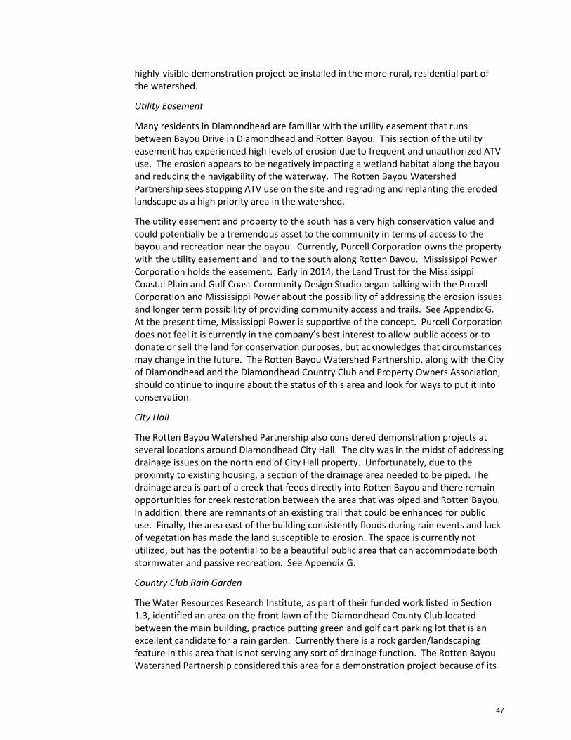
highly-visible demonstration project be installed in the more rural, residential part of the watershed.
Utility Easement
Many residents in Diamondhead are familiar with the utility easement that runs between Bayou Drive in Diamondhead and Rotten Bayou. This section of the utility easement has experienced high levels of erosion due to frequent and unauthorized ATV use. The erosion appears to be negatively impacting a wetland habitat along the bayou and reducing the navigability of the waterway. The Rotten Bayou Watershed Partnership sees stopping ATV use on the site and regrading and replanting the eroded landscape as a high priority area in the watershed.
The utility easement and property to the south has a very high conservation value and could potentially be a tremendous asset to the community in terms of access to the bayou and recreation near the bayou. Currently, Purcell Corporation owns the property with the utility easement and land to the south along Rotten Bayou. Mississippi Power Corporation holds the easement. Early in 2014, the Land Trust for the Mississippi Coastal Plain and Gulf Coast Community Design Studio began talking with the Purcell Corporation and Mississippi Power about the possibility of addressing the erosion issues and longer term possibility of providing community access and trails. See Appendix G. At the present time, Mississippi Power is supportive of the concept. Purcell Corporation does not feel it is currently in the company’s best interest to allow public access or to donate or sell the land for conservation purposes, but acknowledges that circumstances may change in the future. The Rotten Bayou Watershed Partnership, along with the City of Diamondhead and the Diamondhead Country Club and Property Owners Association, should continue to inquire about the status of this area and look for ways to put it into conservation.
City Hall
The Rotten Bayou Watershed Partnership also considered demonstration projects at several locations around Diamondhead City Hall. The city was in the midst of addressing drainage issues on the north end of City Hall property. Unfortunately, due to the proximity to existing housing, a section of the drainage area needed to be piped. The drainage area is part of a creek that feeds directly into Rotten Bayou and there remain opportunities for creek restoration between the area that was piped and Rotten Bayou. In addition, there are remnants of an existing trail that could be enhanced for public use. Finally, the area east of the building consistently floods during rain events and lack of vegetation has made the land susceptible to erosion. The space is currently not utilized, but has the potential to be a beautiful public area that can accommodate both stormwater and passive recreation. See Appendix G.
Country Club Rain Garden
The Water Resources Research Institute, as part of their funded work listed in Section 1.3, identified an area on the front lawn of the Diamondhead County Club located between the main building, practice putting green and golf cart parking lot that is an excellent candidate for a rain garden. Currently there is a rock garden/landscaping feature in this area that is not serving any sort of drainage function. The Rotten Bayou Watershed Partnership considered this area for a demonstration project because of its
47

visibility to the public; ability to filter water coming off the club roof, putting green and parking lot; and opportunity for educational signage that could also point towards other BMPs installed on the Cardinal Golf Course during the project period. While this project was not undertaken during the grant period, it remains a worthwhile and attainable project. See Appendix G.
Conservation and Restoration
Conservation
As part of the Conservation Legacy Project, the Land Trust for the Mississippi Coastal Plain has a map of Potential Conservation Lands that is a model of the suitability of land for conservation based on ranked environmental and land use conditions including wetlands, hydrological soil groups, flood zones, elevation/slope, upland forest and important ecosystems. Areas that are in Rotten Bayou watershed and currently undeveloped were identified as being relatively high priority areas (See Figure 7) in terms of conservation and should be considered in planning and management strategies for Rotten Bayou Watershed. See Section 2.3.5. The LTMCP should continue to work with the City of Diamondhead, the Diamondhead Country Club and Property Owners Association, Purcell Corporation and private landowners within the watershed to acquire property or easements that will protect critical land within the watershed.
Living Shorelines and Streamside Buffers
Streamside buffers and living shorelines are very effective in improving water quality and habitat along waterways. A living shoreline describes a natural approach to shoreline stabilization that reduces erosion while preserving or creating habitat along the shoreline. The recommended visual survey of the waterways in Rotten Bayou Watershed would give a clearer indication of the extent of existing streamside buffers and hardened shorelines. Depending on the results of this survey, outreach and education should be conducted targeting individual property owners. Results of these efforts would be further enhanced by some type of incentive program for homeowners who willingly implement BMPs along the shorelines.
Dredging and Beneficial Use
Currently there are several locations along Rotten Bayou where dredging is desired for increased navigability and/or necessary for habitat restoration. One location is Devil’s Elbow (See Section 2.4.6) and the other is where the utility easement off Bayou Drive in Diamondhead intersects the bayou. The Rotten Bayou Watershed Partnership should stay informed of any projects proposing dredging along Rotten Bayou and, where dredging is determined necessary, ensure that the dredge material is used for beneficial uses including development of wetland habitats.
48
Recreation and Ecotourism
Bayou Access
Rotten Bayou and its tributaries are almost entirely bordered by private property. With very few opportunities for the public to access or even view Rotten Bayou, it is difficult for watershed residents and visitors to understand their connection to this important waterway. There are a few remaining opportunities to provide access to the bayou or allow for recreation near the bayou. One such example is the utility easement running from Bayou Drive in Diamondhead, west to Rotten Bayou. See Priority Projects in Section 3.1.2 Planned Management Actions. The feasibility of this project is contingent on the willingness of current landowners. There are also several other residential properties along Rotten Bayou that are prone to flooding and either have not been developed or have not been redeveloped since Hurricane Katrina. These properties should be considered for conservation and as possible access points to the bayou.
Blueway
Rotten Bayou is navigable by kayak from the Jourdan River up to Kiln-Delisle Road; about 6 stream miles. It is a beautiful and often secluded waterway that would make an excellent addition to the Mississippi Gulf Coasts’ growing list of blueways. Rotten Bayou’s designation as a blueway would forward the goals of this WIP by increasing access to and awareness of Rotten Bayou. Increasing access and awareness is critical to improving water quality in Rotten Bayou because many people in the watershed currently do not feel a connection to the bayou because of lack of access due to private ownership along the bayou. Increasing access points as discussed above will be important to Rotten Bayou becoming a successful blueway. Currently, unless one owns property on the bayou, the only ways to access Rotten Bayou are from Jordan River launches, Diamondhead Marina or roadway overpasses.
Waste and Wastewater
Nonfunctioning Septic Systems
According to a survey done by the Mississippi Department of Health (MSDH) in 2010, pockets of nonfunctioning septic systems remain in Rotten Bayou Watershed. See Figure 11. The most significant clusters are in the western part of Harrison County. Following Hurricane Katrina, sewer and water districts across coastal Mississippi were able to tie-in many areas that were previously on septic systems, primarily using funds through the Coastal Impact Assistance Program (CIAP). Western Harrison County was able to tie in areas just north of Interstate 10, but currently does not have funding to connect any areas still reported as nonfunctioning.78 In the absence of funding to tie-in additional areas on septic systems, an educational campaign about the risks of nonfunctioning septic systems and proper maintenance should target areas in the watershed where high concentrations of septic systems remain.
Diamondhead Water and Sewer District
Diamondhead Water and Sewer District is in the process of relocating its discharge site and wastewater treatment plant. While the discharge point for Diamondhead Water
49

and Sewer District is south of the watershed, due to the tidal influence into Rotten Bayou the effects of this discharge should be more closely connected with planning in the watershed in the future. There is also an opportunity for the Diamondhead Water and Sewer District to work with the DPOA and City of Diamondhead so that effluent can be dispersed on land for irrigation of the Diamondhead Golf Courses and other appropriate sites.
Litter
Curbside recycling
Harrison County currently operates a curbside recycling program. Prior to Hurricane Katrina, Hancock County also had a curbside recycling program, but residents must now bring their recyclable materials to drop-off centers in order to have them recycled. This added inconvenience can be a deterrent to waste management best practices. The Hancock County Solid Waste Authority and local jurisdictions, in collaboration with the Mississippi Recycling Coalition, should work towards reinstating and promoting curbside recycling in Hancock County.
Trash Catches in Commercial Area
The majority of the drainage system in the watershed is made up of swales and ditches, but there are a few areas, especially in the commercial area of Diamondhead, that have curb and gutter. Litter in these areas can easily be washed down the storm drains and into waterways. Trash catches or drain guards installed at the catch basins would help prevent litter from entering the waterways.
Street sweeping
Roadway litter and debris are prominent throughout the watershed and easily make their way into waterways through the drainage system. Regular street sweeping should be coordinated through the county and city road maintenance departments.
Keep Diamondhead Beautiful Extension
Keep Diamondhead Beautiful (KDB) became a registered affiliate of Keep America Beautiful in 2014. The mission of the organization is focused on “beautifying the City of Diamondhead, involving the community in the beautification efforts, continuing to support the sense of pride that already exists in the City of Diamondhead by encouraging the citizens and the administration to provide a clean and litter free environment, by helping to develop landscaping and maintenance plans and projects for the safety and beauty of the City of Diamondhead.”
The City of Diamondhead is relatively litter-free, except for some litter around fast food locations and shopping centers. Roadway litter and illegal dumbing appear to be more of a concern outside of city limits, however, there are no Keep America Beautiful affiliates active in areas of the watershed outside of Diamondhead. Since Diamondhead has relatively few litter problems and the county areas surrounding Diamondhead are essentially a gateway to the city, it would be beneficial for KDB to extend its mission and reach to include other areas in Rotten Bayou Watershed outside of city limits.
50

Adopt-a-Roadway
Currently, adopt-a-highway programs are administered by the federal and state departments of transportation. Eligible roadways include federal and state highways. Through these programs, public and private organizations and individuals agree to clean a one to two mile segment of the highway a certain number of times per year. In exchange, dedication signage and clean-up materials are provided by the Department of Transportation. These programs not only serve to clean-up roadway litter, but also help deter litter in the first place. Drivers and pedestrians that see Adopt-a-Roadway signage and witness volunteers picking up garbage are more likely to think twice about littering in that area. While there are no eligible roadways in Rotten Bayou Watershed, a similar program modeled after the Adopt-a-Highway program could help reduce roadway litter in critical areas of the watershed.
Urban BMPs
Nonstructural
Permeable paving
Currently, the City of Diamondhead’s zoning ordinance does not allow for pervious paving options in commercial parking areas, loading facilities or access drives. By allowing and even encouraging the use of pervious paving options the city would be furthering the environmental goals established in the 25 Year Comprehensive Plan and taking necessary steps to protect water quality in Rotten Bayou and the watershed. See Appendix I: Recommended Ordinance Changes.
Stormwater ordinance
Diamondhead’s current stormwater ordinance is relatively vague and often not clear on where responsibility lies with the city or with the developer. Mississippi’s Water Resources Research Institute has reviewed the stormwater ordinance and made specific recommendations for language that should be modified to make the document more effective. See Appendix I.
Building code
Under current regulations, smaller residential lots in Diamondhead can be filled to elevate land which reduces the area water can be stored within the watershed and may increase flood risk downstream. A grading supplement should be added to the building code to minimize fill allowed on these lots. See Appendix I.
Coastal Technical Manual
Effective stormwater management requires connecting the dots from policy implementation to proper construction and installation of best management practices. Many of the jurisdictions on the coast are looking to implement policies that would allow, incentivize or require pre and post-construction best management practices addressing stormwater runoff, but are unfamiliar with
51

some of the technical aspects or unclear about the implications of certain policies. The State of Georgia addressed this concern and information gap by creating a Stormwater Management Manual. The Georgia Stormwater Management Manual has several volumes including a Policy Guidebook, Technical Handbook and Coastal Supplement. Jurisdictions in Georgia refer to these volumes in their policies and ordinances so that standards and guidelines are clear for all affected parties.
The Mississippi Department of Environmental Quality has developed a similar manual called Erosion Control, Sediment Control and Stormwater Management on Construction Sites and Urban Areas, however, it does not have as many technical details as the Georgia Manual, does not have a coastal supplement and is not used as effectively by jurisdictions in Mississippi as the Georgia Manual is in Georgia. MDEQ should consider adding a coastal supplement to their technical manual so it is more relevant to jurisdictions on the coast or adopting Georgia’s Coastal Stormwater Supplement to the Georgia Stormwater Management Manual. In addition, MDEQ should look to partner with the Mississippi Alabama Sea Grant Consortium, Grand Bay National Estuarine Research Reserve (NERR), or similar organizations and agencies to provide training to jurisdictions and engineers on how to use the manual.
Fertilizer Ordinance
Currently, higher levels of Total Nitrogen (TN) and Total Phosphorus (TP) are being recorded at the gage in Diamondhead indicating that more of the nutrients entering Rotten Bayou are coming from the more urban area of the watershed and most likely from fertilizer use. To address fertilizer use in urban areas many jurisdictions in Florida have adopted some form of a fertilizer ordinance based off of the Florida Department of Environmental Quality’s Model Ordinance for Florida-Friendly Fertilizer Use on Urban Landscapes. See Appendix J: Model Ordinance for Florida-Friendly Fertilizer Use on Urban Landscapes. The City of Diamondhead should consider adopting some form of fertilizer ordinance, in coordination with education and outreach to property owners about responsible fertilizer use, as a means of reducing nutrients entering Rotten Bayou.
Urban Wildlife Population Control
Wildlife populations within urban areas can reach unnatural levels that are not adequately supported by the environment and can negatively affect water quality. Common examples are deer, Canada geese, raccoons, and squirrels. Water quality at the pond off Gex Drive in Diamondhead is an example of a human altered environment that is inviting unnatural levels of geese that are negatively impacting the quality of water flowing into Rotten Bayou. To control populations of urban wildlife, the types, number and health of the populations in comparison to habitat availability should be regularly monitored. Methods of control may include habitat modification or animal relocation.
52

Structural
Pre and Post Construction
Any type of construction or earthwork exposes soil and makes areas more susceptible to erosion. Best management practices for controlling impacts from construction are extremely important, especially given the uptick in development following the recession. For most development, a Stormwater Pollution Prevention Plan is required in which the developer must show what best management practices they intend to implement to minimize impacts downstream.
In the City of Diamondhead, if the site is over five acres, the site is the jurisdiction of MDEQ. A Stormwater Pollution Prevention Plan (SWPPP), Large Construction Notice of Intent (LCNOI) and permit are required and must be filed with MDEQ and the city. Between 10,000 square feet and five acres is the city’s responsibility. The city requires that development in this size range have a permit, Small Construction Notice of Intent (SCNOI) and SWPPP. Under 10,000 square feet does not require a plan or permit.
In Hancock and Harrison Counties, if the site is over five acres, the site is the jurisdiction of the MDEQ. A SWPPP, LCNOI and permit are required. Between one and five acres are the Counties’ responsibility. The counties require that development in this size range have a permit, SCNOI and SWPPP. Under one acre does not require a plan or permit.
MDEQ has a technical guide to assist in the development of these plans titled Erosion Control, Sediment Control and Stormwater Management on Construction Sites and Urban Areas. Volume one, Erosion and Sediment Control Manual, covers BMPs through construction and volume two, Stormwater Runoff Management Manual, covers post construction BMPs. There does not appear to be a lack of regulation or guidance concerning pre and post construction BMPs, however, there are currently active construction sites that do not have adequate controls in place. See Figure 15. The issue appears to be more with lack of capacity to enforce the SWPPP’s. As development continues to increase in Rotten Bayou Watershed, MDEQ and the jurisdictions need to view erosion and stormwater control as a priority and increase their capacity to monitor and enforce SWPPP’s.
53

Figure 15: Active Construction Site in Rotten Bayou Watershed
Source: Kelsey Johnson. Photo taken April 2015
Drainage swale maintenance
The drainage systems in Rotten Bayou Watershed are primarily open, grassy swales. This is an excellent starting point in terms of stormwater management because there are theoretically more opportunities for infiltration than with piped, curb and gutter systems. In order to function at an optimal level, however, swales need to be properly maintained. Maintenance typically involves litter control and maintaining the grass or wetland plant cover. Sediment needs to be removed once it has exceeded 25 percent of the original design volume, but scouring ditches without revegetating only creates more problems downstream. Grass should be mowed to a height of 3-4 inches and alternate planting should be considered where appropriate or where grass has not been successfully established. In addition, during construction it is important to stabilize the embankment either with a temporary grass cover or with natural or synthetic erosion control products. General maintenance guidelines can be found online at http://water.epa.gov/polwaste/npdes/swbmp/Grassed-Swales.cfm
Small Scale Urban BMPs
Rain barrels and rain gardens are examples of smaller scale urban BMPs that can have a significant positive impact on water quality if implemented throughout a community. The Diamondhead Garden Club would be an excellent organization to educate and encourage the community in regards to these practices. In addition, specific species of native vegetation were incorporated in the Diamondhead Duck Pond Demonstration Project to provide residents with examples of plants that can be used in rain gardens or other wet areas of their yards.
54

Agricultural and Rural BMPs
Nonstructural
Logging BMPs
Forested areas within Rotten Bayou Watershed are routinely used for harvesting lumber. Some of these areas are fairly close to Rotten Bayou. An example is the area adjacent to Rotten Bayou Cemetery on the border of Diamondhead and Harrison County. The Mississippi Forestry Commission (MFC) encourages BMPs in regards to forestry and logging and has a guide called Best Management Practices for Forestry in Mississippi. MFC could go a step further, however, and incentivize implementation of these practices. In Missouri, the Missouri Department of Conservation implemented a cost-share program designed to be a partnership between the logger and property owner.79 The MDC pays loggers $10 to $20 per acre and landowners $5 for every acre in which they implement BMPs. Funding was provided through a Natural Resources Conservation Service Conservation Innovation Grant.
Ordinances can also help improve logging practices through regulation and/or incentives. An example of such an ordinance is from Carbon County, Utah, where County Commissioners passed a Timber Harvest Ordinance. Property owners are required to submit an application and obtain a permit to harvest timber when it will exceed a certain tonnage. The ordinance also called for the selection and appointment of a professional County Forester. This person administers the ordinance by reviewing permit applications, issuing permits to qualifying applicants, and inspecting logging jobs on private land. Other forest practices addressed include road maintenance, winter operations, site preparation, regeneration, revegetation, chemical management, and prescribed burns.80 Hancock and Harrison Counties should consider using a similar mechanism to increase the implementation of logging BMPs.
Structural
The following structural, agricultural BMPs were implemented as part of the Rotten Bayou Watershed Agricultural Nonpoint Source Pollution Project and are recommended for continued implementation.
Water and Sediment Control Basin
Water and sediment control basins are designed to trap sediment, reduce erosion, reform the land surface and improve water quality. The basins usually consist of a short embankment or combination ridge and channel generally constructed across the slope and minor watercourses.
Heavy Use Area Protection
Heavy use area protection methods reinforce locations that are frequented by livestock by establishing vegetative cover, surfacing with suitable materials, or
55
installing needed structures. Heavy use protection areas are often combined with tanks or troughs that hold drinking water for livestock.
Fencing
Fencing should be strategically placed to exclude livestock from areas that should be protected from grazing or access, such as waterways.
Pond (Alternative Water Source)
Ponds can be installed by constructing a dam or an embankment or by excavating a pit or dug out. Ponds can serve to catch and store runoff and act as a water source for livestock.
Critical Area Planting
Appropriate vegetation should be planted in areas that are critically eroded or likely to experience erosion. It is important for water quality for any eroded/erodible areas to be planted, it is emphasized here for rural and agricultural zones because these areas can easily go overlooked on larger plots of land.
3.2 Education and Outreach Activities
Education and outreach efforts were critical to developing the Rotten Bayou WIP and informing the community about challenges and opportunities that affect the water quality in Rotten Bayou Watershed. Outreach efforts began in the spring of 2014 and have continued through the duration of the project period. Activities included developing various materials and signage, hosting workshops, and coordinating activities with local schools. Section 3.2.1 gives a summary of education and outreach activities that have been completed during the development of the WIP while Section 3.2.2 describes recommended activities to be implemented in the future.
3.2.1 Summary of Activities Conducted During the Planning Period
Goals
1. Increase awareness of watershed and Rotten
Bayou Watershed Plan
2. Improve stakeholder knowledge of watershed
dynamics
3. Inspire residents and stakeholders to take action
4. Develop a plan for ongoing educational
opportunities and engagement
56
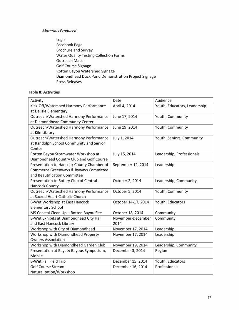
Materials Produced
Logo Facebook Page Brochure and Survey Water Quality Testing Collection Forms Outreach Maps Golf Course Signage Rotten Bayou Watershed Signage
Diamondhead Duck Pond Demonstration Project Signage Press Releases
Table 8: Activities
Activity Date Audience
Kick-Off/Watershed Harmony Performance at Delisle Elementary
April 4, 2014 Youth, Educators, Leadership
Outreach/Watershed Harmony Performance at Diamondhead Community Center
June 17, 2014 Youth, Community
Outreach/Watershed Harmony Performance at Kiln Library
June 19, 2014 Youth, Community
Outreach/Watershed Harmony Performance at Randolph School Community and Senior Center
July 1, 2014 Youth, Seniors, Community
Rotten Bayou Stormwater Workshop at Diamondhead Country Club and Golf Course
July 15, 2014 Leadership, Professionals
Presentation to Hancock County Chamber of Commerce Greenways & Byways Committee and Beautification Committee
September 12, 2014 Leadership
Presentation to Rotary Club of Central Hancock County
October 2, 2014 Leadership, Community
Outreach/Watershed Harmony Performance at Sacred Heart Catholic Church
October 5, 2014 Youth, Community
B-Wet Workshop at East Hancock Elementary School
October 14-17, 2014 Youth, Educators
MS Coastal Clean Up – Rotten Bayou Site October 18, 2014 Community
B-Wet Exhibits at Diamondhead City Hall and East Hancock Library
November-December 2014
Community
Workshop with City of Diamondhead November 17, 2014 Leadership
Workshop with Diamondhead Property Owners Association
November 17, 2014 Leadership
Workshop with Diamondhead Garden Club November 19, 2014 Leadership, Community
Presentation at Bays & Bayous Symposium, Mobile
December 3, 2014 Region
B-Wet Fall Field Trip December 15, 2014 Youth, Educators
Golf Course Stream Naturalization/Workshop
December 16, 2014 Professionals
57

From Policy to Practice: Lessons learned from Georgia's Stormwater Management Approach
March 26-27, 2015 Leadership, Professionals
Presentation at Mississippi Water Resources Conference, Jackson
April 7, 2015 State
Outreach at Celebrate the Gulf April 11, 2015 Community
B-Wet Spring Field Trip April 21, 2015 Youth, Educators
B-Wet In-class Wrap-up April 24, 2015 Youth, Educators
B-Wet Exhibition as Part of Diamondhead Spring Pilgrimage
April 22-24, 2015 Community
Demonstration Project and Educational Signage at Diamondhead Duck Pond
July-September 2015 Community
3.2.3 Future Outreach and Education Activities
A full listing of potential education and outreach activities recommended for Rotten Bayou Watershed including responsible parties, potential funders, estimated costs and a recommended implementation timeline is included in Appendix H: Management Action.
Facebook Page
The Rotten Bayou Watershed Partnership’s Facebook Page (www.facebook.com/rottenbayou) has been the primary means of communicating with interested residents. Facebook is free and allows the partnership to update residents on current happenings and gather feedback on pertinent issues. During the project period, staff at the Gulf Coast Community Design Studio created and maintained the Facebook page. As the project concludes, one to two people who plan to continue as members of the Rotten Bayou Watershed Partnership should be nominated by the Steering Committee to be administrators of the Facebook page.
MS Coastal Cleanup
Rotten Bayou is a registered site of the Mississippi Coastal Cleanup. In the past volunteers have met at the Diamondhead Marina to clean up trash in the immediate area. The Rotten Bayou Watershed Partnership became actively involved in the cleanup at this site in October 2014 and should continue to participate to encourage the cleanup efforts to extend further up Rotten Bayou.
Projects for Scout Troops
Many Boy and Girl Scout troops are active in Rotten Bayou Watershed. Often these young men and women are looking for volunteer projects to help complete requirements of their programs. Appendix K includes sample projects for Boy Scouts related to the Soil and Water Conservation Badge. As updates are made to the Rotten Bayou WIP more sample projects should be developed and disseminated to active troops.
Septic System Maintenance
In the absence of funding to tie-in additional areas on septic system, an educational campaign about the risks of nonfunctioning septic system and proper maintenance should target areas in the watershed where high concentrations of septic systems remain.
58

Signage
Strategically placed signage with an educational component can be a very cost-effective way to increase community members’ awareness of water quality challenges and best management practices. Currently, educational signage has been installed at the locations where BMPs were completed on Diamondhead’s Cardinal Golf Course and at the Duck Pond Demonstration Project located off Gex Drive in Diamondhead. See Appendices E and F. Similar signage should be installed where possible when publically accessible BMPs are installed. In addition, if publically accessible access point or trails are created on or near Rotten Bayou, signage with an educational component should be included in the plans.
Pet Waste
While the current level of pathogen testing does not distinguish between septic waste, domestic animal waste and wildlife, anecdotally, there appears to be an excessive amount of pet waste that is left on the ground. Bacteria in pet waste does break down naturally, however the ecosystem cannot handle the number of domestic dogs typically concentrated in a small area. The natural ecosystem can only handle two canines in a square mile. In urban areas, there are often as many as 125 dogs per square mile. Education around proper disposal of pet waste should be distributed by the local jurisdictions, the DPOA, and local pet-related businesses such as veterinary clinics. Signage and waste receptacles should also be provided in areas where people frequently walk pets.
Education in Schools
During the project period, Bayou Town Productions worked with the Rotten Bayou Watershed Partnership to schedule performances of their Watershed Harmony Puppet show at schools and libraries that are either in the watershed or cater to residents who live in the watershed (See Table 6: Activities). The Partnership should continue to work with Bayou Town Productions and other providers of educational programs to coordinate regular sessions in the schools, libraries and other community venues. The Mississippi Department of Transportation, for example, does an anti-litter presentation geared towards kindergarten through third grade.81 This program was not engaged during the project period, but would be an excellent partner to consider for future outreach and education efforts.
During the project period the Gulf Coast Community Design Studio secured funding from NOAA’s Gulf of Mexico Bay-Watershed Education and Training Program (Gulf B-WET) for the 2014-2015 school year to work with fifth graders at East Hancock Elementary School (See Appendix L: Elementary Education for Rotten Bayou Watershed). The grant funding not only allowed GCCDS staff to work with students during the 2014-2015 school year, but provided supplies and training to teachers to continue the program in future years. The Rotten Bayou Watershed Partnership should check in with East Hancock Elementary School at the beginning of each school year to encourage reuse of the program and materials and see if there is any way the Partnership can be of assistance. In addition, some of the children in the watershed go to Delisle Elementary School, part of the Pass Christian School District. There may be an opportunity for this program to be shared with Delisle Elementary School so that more children in the watershed are reached.
59

Promote Use of Native Plants
Use of native plants, especially in areas that tend to remain wet, are susceptible to erosion, or are near waterways, can have a positive and substantial effect on water quality. Many residents would likely be willing to use native plants in place of grass or invasive varieties if they knew what to plant and the benefits of doing so. The Diamondhead Garden Club and Pine Hills Nursery, the only nursery in Rotten Bayou Watershed, would be ideal promoters of the use of native plants. Both have been involved with the Rotten Bayou Watershed Project and the Rotten Bayou Watershed Partnership should continue to work with these and other potential partners to promote the use of native plants and other BMPs (See Section 3.1.2).
Establish More Connections with County Residents
Establishing connections with residents in rural areas can be a challenge given the dispersed nature of development. Often churches or civic organizations can be a good and efficient way to connect with county residents. During the funded project period, the Rotten Bayou Watershed Partnership was able to work with Sacred Heart Catholic Church, a church located at the top of the watershed that draws its membership from the Fenton/Dedeaux communities. The timing of the project, however, did not align well with changes in church leadership and all of the planned work and educational activities could not be completed. The Rotten Bayou Watershed Partnership should continue to work with Sacred Heart Catholic Church, other churches in the area, and organizations such as the Knights of Columbus to better engage county residents.
Workshops with Local Leadership
While several of the workshops conducted during the Rotten Bayou Watershed project period focused on educating local leadership on BMPs that would improve water quality in Rotten Bayou, continuing education with this particular stakeholder group is needed (See Table 6: Activities). In addition, while there was significant participation from leadership in Diamondhead at the workshops and some representation from both Hancock and Harrison Counties, more effort needs to be made to encourage leadership from the counties to attend future trainings. Two specific areas where more training is needed are swale maintenance and adopting and enforcing ordinances.
3.3 Plan Evaluation and Revision
3.3.1 Monitoring Plan
MDEQ
MDEQ, in conjunction with USGS, conducted water quality monitoring prior to the implementation of BMP activities. Monitoring was suspended to allow for BMP installation. Once BMP installation is completed, MDEQ and USGS will re-instate monitoring activities in an effort to show water quality improvements. The timeline and extent of future monitoring is still to be determined. MDEQ is also considering monitoring Rotten Bayou for pathogens including Fecal Coliform and E. Coli for an additional year.
60
Research and Education to Advance Conservation and Habitat (REACH)
REACH plans to collect storm runoff samples from the following locations just downstream of where BMPs have been installed in Rotten Bayou Watershed:
Dry Swale on hole one of Diamondhead’s Cardinal Golf Course.
Naturalized stream segment on hole two of Diamondhead’s Cardinal Golf Course.
Control Site at hole one of Diamondhead’s Cardinal Golf Course.
Stream naturalization adjacent to overflow at Diamondhead Duck Pond.
Diamondhead Country Club and Property Owners Association is also looking to implement BMPs on holes two and seven of the Pine Golf Course this summer. If these are installed, REACH plans to monitor these as well. All of the golf course samples are run through the MDEQ for TN, nitrate-nitrite, ammonia, ortho-phosphorus and suspended sediment.
Sample and discharge readings were taken at Diamondhead Duck Pond prior to the stream naturalization. One set of samples will be run for nutrients including nitrate-nitrite, ammonia, ortho-phosphorus, TP, TN, and total suspended solids. The other set will be sent to the USDA and run for fecal coliforms and e. coli. REACH plans to monitor these sites through October 2015.
Restore Corps
Climb Community Development Corporation (Climb CDC) is a nonprofit Mississippi community development agency whose mission is to promote strong communities by providing individuals access to opportunities that inspire self-reliance. As part of its workforce training program, CLIMB CDC formed a Gulf Coast Restore Corps that is part of the national Corps Network. The Restore Corps will participate in projects related to the restoration of the Gulf of Mexico from the effects of the 2010 Oil Spill. The team is able to provide services including monitoring water quality, conducting visual waterway assessments, and implementing or providing ongoing maintenance for restoration/recreation projects. Fees for services are relatively minimal and are determined at the time the services are requested. If state agencies such as MDEQ and USGS are not able to continue monitoring Rotten Bayou in the future, the Rotten Bayou Watershed Partnership should consider partnering with paid and semi-professional groups like the Gulf Coast Restore Corps for periodic monitoring and assessment.
Schools
As mentioned in sections 1.3 and 3.2, the Gulf Coast Community Design Studio secured funding from NOAA’s Gulf of Mexico Bay-Watershed Education and Training Program (Gulf B-WET) for the 2014-2015 school year to work with fifth graders at East Hancock Elementary School. See Appendix L: Elementary Education for Rotten Bayou Watershed. The grant funding not only allowed GCCDS staff to work with students during the 2014-2015 school year, but provided supplies and training to teachers to continue the program in future years. The Rotten Bayou Watershed Partnership should contact East Hancock Elementary School at the beginning of each school year to encourage continued monitoring of Rotten Bayou and information sharing between the school, Rotten Bayou Watershed Partnership and larger community.
61

Watchful Stewards Program
Much of the information about changes in Rotten Bayou over time was gathered anecdotally from people who either live or recreate on the bayou. Since there is currently no direct public access to Rotten Bayou, it will be important for the Rotten Bayou Watershed Partnership to maintain relationships with people who have constant visual or physical contact with the bayou. The partnership may want to consider instating a more formal Watchful Stewards Program where residents can regularly report on changes to the bayou environment or concerns or opportunities that should be addressed by the partnership.
3.3.2 Adaptive Management and Plan Revision
The goals, objectives and resulting strategies and recommendations included in the Rotten Bayou Watershed Implementation Plan have been determined based on an assessment conducted between 2012 and 2015. Environmental and socioeconomic conditions are ever changing. These conditions, as well as any implemented Best Management Practices, will likely have an impact on the watershed and water quality in Rotten Bayou. As such, the Rotten Bayou Watershed Partnership should plan to conduct an integrated assessment of Rotten Bayou Watershed on a routine basis and make adjustments or amendments to the Rotten Bayou Watershed Implementation Plan as justified by the results of the assessments. According to the Mississippi Coastal Nutrient Reduction Strategy, “five years is considered adequate for observing near-field changes in water quality from the implementation of various management practices in the watershed.”82 The Rotten Bayou Watershed Partnership should begin conducting its first assessment and plan revision in 2020.
62

1 U.S. Environmental Protection Agency. Handbook for Developing Watershed Plans to Restore and Protect Our Waters. (2008). Pg. 2-2. <http://www.epa.gov/owow/nps/watershed_handbook> 2 U.S. Environmental Protection Agency. Handbook for Developing Watershed Plans to Restore and Protect Our Waters. (2008). Pg. 2-2. <http://www.epa.gov/owow/nps/watershed_handbook> 3 U.S. Environmental Protection Agency. Handbook for Developing Watershed Plans to Restore and Protect Our Waters. (2008). Pg. 2-14. <http://www.epa.gov/owow/nps/watershed_handbook> 4 FTN Associates, Ltd. Prepared for Mississippi Department of Environmental Quality. Mississippi Coastal Nutrient Reduction Strategies. (2011). Pg. 1. <http://www.deq.state.ms.us/Mdeq.nsf/pdf/WMB_MSCoastalNutrientReductionStrategies/$File/Mississippi%20Coastal%20Nutrient%20Reduction%20Strategies.pdf?OpenElement> 5 U.S. Department of Agriculture. Press Release No. 0499.11. Agriculture Secretary Vilsack Announces $50 Million for Gulf Coast Restoration. (2011). <http://www.usda.gov/wps/portal/usda/usdahome?contentidonly=true&contentid=2011/12/0499.xml>. 6 Mississippi Department of Environmental Quality, Office of Pollution Control Standards, Modeling, and TMDL Branch. Total Maximum Daily Load For Nutrients and Organic Enrichment/Low DO In Listed Tributaries to St. Louis Bay Coastal Streams Basin. (2007). Pgs. 7-8. 7 Mississippi Department of Environmental Quality, Office of Pollution Control Standards, Modeling, and TMDL Branch. Total Maximum Daily Load For Nutrients and Organic Enrichment/Low DO In Listed Tributaries to St. Louis Bay Coastal Streams Basin. (2007). Pg. 35. 8 Scharff, Robert G. Louisiana’s Loss, Mississippi’s Gain: A History of Hancock County, Mississippi from the Stone Age to the Space Age. (1999). Lawrenceville, VA: Brunswick Publishing Corporation. Pg. 61. 9 Ellis, Dan. Kiln Kountry: Home of Brett Farve. (2000). Self Published. Pg. 4. 10 Scharff, Robert G. Louisiana’s Loss, Mississippi’s Gain: A History of Hancock County, Mississippi from the Stone Age to the Space Age. (1999). Lawrenceville, VA: Brunswick Publishing Corporation. Pg. 28. 11 Scharff, Robert G. Louisiana’s Loss, Mississippi’s Gain: A History of Hancock County, Mississippi from the Stone Age to the Space Age. (1999). Lawrenceville, VA: Brunswick Publishing Corporation. Pg. 75. 12 Scharff, Robert G. Louisiana’s Loss, Mississippi’s Gain: A History of Hancock County, Mississippi from the Stone Age to the Space Age. (1999). Lawrenceville, VA: Brunswick Publishing Corporation. Pg. 173. 13 Hancock County Historical Society. Website. Accessed January 2014. < http://www.hancockcountyhistoricalsociety.com/reference/alphabetfile.htm?page=194> 14 Hickman, Nollie W. Mississippi Harvest: Lumbering in the Longleaf Pine Belt, 1840-1915. (2009). Jackson, MS: University Press of Mississippi. 15 Ellis, Dan. Kiln Kountry: Home of Brett Farve. (2000). Self Published. Pg. 27. 16 Ellis, Dan. Kiln Kountry: Home of Brett Farve. (2000). Self Published. Pg. 24. 17 Ellis, Dan. Kiln Kountry: Home of Brett Farve. (2000). Self Published. Pg. 25. 18 Ellis, Dan. Kiln Kountry: Home of Brett Farve. (2000). Self Published. Pg. 29. 19 Scharff, Robert G. Louisiana’s Loss, Mississippi’s Gain: A History of Hancock County, Mississippi from the Stone Age to the Space Age. (1999). Lawrenceville, VA: Brunswick Publishing Corporation. Pg. 177-178. 20 Hancock County Historical Society. Website. Accessed January 2014. < http://www.hancockcountyhistoricalsociety.com/reference/cemetery.htm?cemetery=ROT>. 21 Scharff, Robert G. Louisiana’s Loss, Mississippi’s Gain: A History of Hancock County, Mississippi from the Stone Age to the Space Age. (1999). Lawrenceville, VA: Brunswick Publishing Corporation. Pg. 599-600. 22 Gulf Regional Planning Commission. Current Land Use Inventory GIS Database. (2013). Analysis by Gulf Coast Community Design Studio. 23 Gulf Regional Planning Commission. Future Land Use Inventory GIS Database. (2013). Analysis by Gulf Coast Community Design Studio. 24 Gallo, Cory. Mississippi State University, Water Resources Research Institute. Presentation for MDEQ and Rotten Bayou Watershed Implementation Team. 21 March 2013. 25 U.S. Census Bureau. Income, Poverty, and Health Insurance Coverage in the United States: 2010. (2011). <http://www.census.gov/prod/2011pubs/p60-239.pdf>.
63

26 U.S. Department of Agriculture. Geography of Poverty. <http://www.ers.usda.gov/topics/rural-economy-population/rural-poverty-well-being/geography-of-poverty.aspx#.Uwyu5IW5FO1>. Accessed 25 February 2014. 27 Glaster, George C. Consequences from the Redistribution of Urban Poverty during the 1990's: A Cautionary Tale. (2003). National Poverty Center Working Paper Series #03-9. <http://moodle.technion.ac.il/pluginfile.php/129000/mod_resource/content/0/Galster_A_Cautionary_Tale_consequences_from_the_redistribution_of_urban_poverty_during_the_1990s.pdf>. 28 U.S. Census Bureau. (2010). 1990-2010 Decennial Census. Table QT-H1. General Housing Characteristics. 29 Plan for Opportunity. Water Assessment. Pg 18. 30 Starnes, James. Mississippi Department of Environmental Quality. Office of Geology. Phone Conversation 1 December 2014. 31 United States Department of Agriculture. Natural Resource Conservation Service. Custom Soil Resource Report for Hancock County, Mississippi, and Harrison County, Mississippi: Soil Survey for Rotten Bayou Watershed. <http://websoilsurvey.sc.egov.usda.gov>. Accessed 20 August 2014. 32 United States Department of Agriculture. Natural Resource Conservation Service. (2007). National Engineering Handbook. Part 630 Hydrology. Pg. 7-1. 33 United States Environmental Protection Agency. Western Ecological Division. Ecoregion Maps and GIS Resources. <www.epa.gov/wed/pages/ecoregions/htm>. Accessed 21 November 2014. 34 Bailey, Robert G. and James M. Omernik. (1997). Distinguishing between Watersheds and Ecoregions. Journal of the American Water Resources Association. Vol. 33, No. 5. Pg. 937. 35 Bailey, Robert G. and James M. Omernik. (1997). Distinguishing between Watersheds and Ecoregions. Journal of
the American Water Resources Association. Vol. 33, No. 5. Pg. 937.Pgs 945-947 36 United States Environmental Protection Agency. Western Ecological Division. Ecoregion Maps and GIS Resources. <www.epa.gov/wed/pages/ecoregions/htm>. Accessed 21 November 2014. 37 United States Environmental Protection Agency. Western Ecological Division. Ecoregion Maps and GIS Resources. <www.epa.gov/wed/pages/ecoregions/htm>. Accessed 21 November 2014. 38 United States Environmental Protection Agency. Western Ecological Division. Ecoregion Maps and GIS Resources. <www.epa.gov/wed/pages/ecoregions/htm>. Accessed 21 November 2014. 39 United States Environmental Protection Agency. Coastal Wetlands. <http://water.epa.gov/type/wetlands/cwt.cfm>. Accessed 1 December 2014. 40 Plan for Opportunity. Water Assessment. Pg 68. 41 State of Mississippi. Mississippi Code of 1972. Section 57-15-6. Pg VIII-4. 42 Mississippi Department of Marine Resources. Coastal Zone Management < http://www.dmr.state.ms.us/index.php/coastal-zone-management/wetland-permitting>. Accessed 25 November 2014. 43 Mississippi State University. Department of Geosciences. <http://geosciences.msstate.edu/scClimate.htm>. Accessed 5 December 2014. 44 Mississippi State University. Department of Geosciences. <http://geosciences.msstate.edu/scClimate.htm>. Accessed 5 December 2014. 45 Ohio State University. (2012). Mississippi Gulf Coast Water Assessment. Pg 81. 46 Ohio State University. (2012). Mississippi Gulf Coast Water Assessment. Pg 68. 47 Ohio State University. (2012). Mississippi Gulf Coast Water Assessment. Pg 86. 48 CDM Smith, Inc. Prepared for Land Trust for the Mississippi Coastal Plain. Conservation Legacy: Conservation Mapping Report. (2011). Pg. 3. <http://www.ltmcp.org/links/conservation-legacy/>. 49 Ohio State University. (2012). Mississippi Gulf Coast Water Assessment. Pg 22. 50 Ohio State University. (2012). Mississippi Gulf Coast Water Assessment. Pg 44. 51 Phillips, Patrick. Mississippi Department of Environmental Quality, Office of Land and Water Resources. Email correspondence 15 October 2014. 52 Ohio State University. (2012). Mississippi Gulf Coast Water Assessment. Pg 23. 53 Ohio State University. (2012). Mississippi Gulf Coast Water Assessment. Pg 76. 54 Ohio State University. (2012). Mississippi Gulf Coast Water Assessment. Pg 23. 55 Phillips, Patrick. Mississippi Department of Environmental Quality, Office of Land and Water Resources. Email correspondence 5 December 2014.
64

56 Phillips, Patrick. Mississippi Department of Environmental Quality, Office of Land and Water Resources. Email correspondence 15 October 2014. 57 Ohio State University. (2012). Mississippi Gulf Coast Water Assessment. Pg 46. 58 Collard, Michael. Diamondhead Water and Sewer District. Email correspondence. 10 December 2012. 59 Mississippi Department of Wildlife, Fisheries and Parks (October 2008) 2009-2014 Statewide Comprehensive Outdoor Recreation Plan, table I. 60 Necaise, Paul. U.S Fish and Wildlife Service. Coastal Biologist, Hancock County. Personal Communication. 2 February 2015. 61 Mississippi Department of Environmental Quality, Office of Pollution Control. (2007). State of Mississippi Water Quality Criteria for Intrastate, Interstate, and Coastal Waters. Pg. 17. 62 Mississippi Department of Environmental Quality, Office of Pollution Control. (2007). State of Mississippi Water Quality Criteria for Intrastate, Interstate, and Coastal Waters. Pg. 17. 63 Anchor QEA, LLC. Prepared for Land Trust of the Mississippi Coastal Plain. (2014). Rotten Bayou Water Quality Assessment. Pg. 1. 64 Mississippi Department of Environmental Quality, Office of Pollution Control. (2007). Total Maximum Daily Load for Nutrients and Organic Enrichment/Low DO in Listed Tributaries to St. Louis Bay Coastal Streams Basin. Pg. 5. 65 Tetra Tech, Inc. Prepared for Mississippi Department of Environmental Quality, Office of Pollution Control. (2011). Revised Draft Nutrient Thresholds to Protect Aquatic Life Uses in Mississippi Non-Tidal Streams and Rivers. 66 Tetra Tech, Inc. Prepared for Gulf of Mexico Alliance. (2013). Sources, Fate, Transport, and Effects (SFTE) of Nutrients as a Basis for Protection Criteria in Estuarine and Near-Coastal Waters: Saint Louis Bay, Mississippi Pilot Study. 67 Anchor QEA, LLC. Prepared for Land Trust of the Mississippi Coastal Plain. (2014). Rotten Bayou Water Quality Assessment. Pg. 3. 68 Anchor QEA, LLC. Prepared for Land Trust of the Mississippi Coastal Plain. (2014). Rotten Bayou Water Quality Assessment. Pg. 6. 69 Anchor QEA, LLC. Prepared for Land Trust of the Mississippi Coastal Plain. (2014). Rotten Bayou Water Quality Assessment. Pg. 6. 70 Anchor QEA, LLC. Prepared for Land Trust of the Mississippi Coastal Plain. (2014). Rotten Bayou Water Quality Assessment. Pg. 6. 71 Anchor QEA, LLC. Prepared for Land Trust of the Mississippi Coastal Plain. (2014). Rotten Bayou Water Quality Assessment. Pg. 8. 72 Anchor QEA, LLC. Prepared for Land Trust of the Mississippi Coastal Plain. (2014). Rotten Bayou Water Quality Assessment. Pg. 8. 73 Alley, Valerie. Mississippi Department of Environmental Quality, Office of Pollution Control. Email communication 8 July 2015. 74 Compton Engineering, Inc. Prepared for Diamondhead Property Owners Association. (2012). Sedimentation and Erosion Remediation and Maintenance Plan for Drainage Ditches Discharging into Devil’s Elbow, Diamondhead, Hancock County, Mississippi, Project # 211-066. Pg 5. 75 Ray, Tim. Mississippi State University Extension Service, Harrison County. Email correspondence 14 January 2014. 76 University of Oregon. Ecosystem Workforce Program. (2009). Keys to Success for Watershed Management Organizations. Pg 6. 77 California Department of Conservation. Watershed Coordinator Grant Program. <http://www.conservation.ca.gov/dlrp/wp/grants/Pages/wcgp_intro.aspx>. Accessed 12 May 2015. 78 Harrison County Utility Authority. Virgil Gillespie, Board Director. Personal Communication. 4 May 2015. 79 Missouri Department of Conservation. BMP Cost-Share Funds Available for Loggers and Landowners. 30 January 2013. < http://mdc.mo.gov/newsroom/bmp-cost-share-funds-available-loggers-and-landowners>. Accessed 12 June 2015. 80 Utah State University Extension. Utah Forest News: Utah Forest Landowner Education Program Newsletter. Fall 2000. Volume 4, Number 4. <https://forestry.usu.edu/files/uploads/UFN/Fall00.pdf>. Accessed 12 June 2015 81 Mississippi Department of Transportation. Don’t Trash Mississippi. <http://sp.mdot.ms.gov/Maintenance/thinkgreen/Pages/home.aspx>. Accessed 15 June 2015.
65

82 Mississippi Department of Environmental Quality. 2011. Prepared by FTN Associates, Ltd. Mississippi Coastal Nutrient Reduction Strategies. Pg 44.
66