Embed Size (px)
Citation preview

THE REPUBLIC OFNAMIBIA
Ministry of AgricultureWater and RuralDevelopment
Department of WaterAffairs (DWA)Directorate ofRural Water Supply (DRWS)
THE REPUBLIC OFFINLAND
Ministry for ForeignAffairs
Finnish InternationalDevelopment AgencyFINNIDA
WATER SUPPLY AND SANITATION PROJECT
IN OHANGWENA REGION, NAMIBIA
r.
FINNCONSULT OY
Project No. 28103701-8
ENVIRONMENTAL IMPACT ASSESSMENT STUDY
OCTOBER 1994
DRAFT REPORT No. 1
824—NAOH—13207


WATER SUPPLY AND SANITATION PROJECT IN OHANGWENA REGION, NAMIBIA
ENVIRONMENTAL IMPACT ASSESSMENT STUDYOCTOBER 1994DRAFT REPORT NO. I
TABLE OF CONTENTS
LOCATION MAPS
EXECUTIVE SUMMARY
1 INTRODUCTION 1
2 OBJECTIVES OF THE STUDY 2
3 MATERIALS AND METHODOLOGY 3
4 DESCRIPTION OF ENVIRONMENTAL AND SOCIO-ECONOMICCONDITIONS 44.1 Location and General Area Description 44.2 Climatic Conditions 74.3 Geology and Soils 104.4 Surface Water Resources and Drainage System 124.5 Groundwater Resources 214.6 Vegetation and Wildlife 234.7 Population, Human Settlements and Infrastructure 294.8 Land-use Patterns and Farming Systems 314.9 An Overview of Environmental Degradation 414.10 Household Structure, Economy and Incomes 514.11 Social Conditions and Services 52
5 DESCRIPTION OF THE WATER SUPPLY AND SANITATION PROJECTIN WESTERN OHANGWENA REGION (WSSPOR) 55
6 INSTITUTIONAL FRAMEWORK FOR WATER SUPPLYDEVELOPMENT 59
7 ENVIRONMENTAL ISSUES IN WATER SUPPLY AND SANITATIONDEVELOPMENT 61
8 WATER SUPPLY DEVELOPMENT AND LAND-USE PLANNING 65
9 COMPARISON OF ENVIRONMENTAL CONSEQUENCES ANDOPPORTUNITIES OF ALTERNATIVE WATER SUPPLY OPTiONS 67
10 REQUIREMENTS FOR ENVIRONMENTAL MQNITORING 72
11 SUMMARY OF RECOMMENDATIONS 73
I~j ~ ...
2 ~4 W,1?O H ~‘LL~:______


ANNEXES:
1 Terms of Reference for EIA Study2 List of Persons and Organisations Consulted3 Literature and References4 Itinerary and Work Programme5 Photographs


LIST OF FIGURES, MAPS AND TABLES
Figures
Figure 1 Average Monthly Rainfall, and Maximum and Minimum Temperatures InOndangwa; Rainfall 1902-1975, Temperatures 1944-1975 9
Figure 2 Diagram of Water Balance (DWA) 9Figure 3 Schematic Layout of the Herringbone Water Supply System 20Figure 4 Diagram Showing Groundwater Aquifers and Recharge Systems and
Location of Wells and Omafima 22Figure 5 Layout of a typical Owambo farm 33Figure 6 Schematic Presentation of Agroforestry System . . 49Figure 7 Framework of Project Environment 57Figure 8 Project Organogram 58Figure 9 Risks Related to Improved Water Supply in Ecologically Fragile Areas
with Extensive Livestock Rearing 62
Maps
Map 1 General Location Map After Table of ContentsMap 2 Overall Map of Western Ohangwena Region After Table of ContentsMap 3 Administrative Boundaries 5Map 4 Simplified Population Density 5Map 5 Population Density in Owambo 1985 6Map 6 Major Groundwater Areas and Simplified Soil Distribution 13Map 7 The Cuvelai Drainage System in Southern Angola and Owambo 15Map 8 Existing and Proposed Canals and Pipelines in Owambo . . 18Map 9 Existing and Proposed Pipelines of the Herringbone System in Western
Ohangwena Region and Oshakati-Ondangwa Area 19Map 10 Vegetation Types 24Map 11 Settlement Pattern around Ondobe . . 34Map 12 Settlement Pattern around Egambo, southwest of Eenhana . . . 35Map 13 Location of Owambo Communities in the 1850’s . . 45Map 14 Deforestation of Dry Deciduous Forest in Owambo 47
Tables
Table 1 Longterm Monthly Mean Values Of Temperature, Relative Humidityand Rainfall at Ondangwa 8
Table 3 Owambo - General Geology and Stratigraphy 11Table 4 Principal Characteristics of Most Common Trees in the Study Area 28Table 5 Major Centres In and Around Ohangwena Region 30Table 6 Comparison of Livestock Numbers in Owambo in 1945, 1973 and 1992 .. 40Table 7 Numbers of Clinical Cases of Common And/Or Serious Diseases in
Owambo During 1989-92 52

- \ . ‘.,
Te~1W~
~
ll’~k b metres/ kiIometers/k~bometern
0 25 50 75 100 125-~
200
Savate’~\
C
150-~
100
I—-’
C
ct~u
~dOT
Ombaru
S
40 60 80rntles/ myl/ meile
-~ — ItI~(~/ ...~ J’v~F
1135
0
tl
tl0
‘-3H0
btjitoko ...~
- . ..,~ ‘~‘~c~c;h•
~ 1 ~ — —~, \ r ~ ~—~---—‘~: ~.,—_-_ ~ \~iril,t’j,zooAu / 7 i I — \\...DilDt ~~ Okatjuru -, ~‘7~ \SP(Ifl ~ ~ t..o~s’..-ha. :- ~ ~ ~ c ~
~ — / .~.•,•. ~. -.~ . . .. . .. .. . . . -. . - . — . —— —~ - — -
P a ii N1amu~tonT ? ~ ~
ETOSHAI~TIdNAL1PARK.~ ~ La Rochelie
~ Sprokieswoud ..‘ . . . . . -
Flaunted Forest~ Halali ‘1’ (J]’v\~~~‘
- * ~-~---—“ + .~
0Otjovasa Okaukuejo ~ Coma Iiji~~’i~ 1~umel
V (5’ ~ - Bobo— Hobetare “,.~ -
Tsobi


I~1~ ~ -
~ ~ ~ ~ •:r~• .~: L. ~. - - -
~.
~ ~ ~ . —.
—
N G
Maa IC
RegionConstituencYProlect area
— Main tarred road
— Main gravel road* Main town• Main growmng center• Growing point
MAP 2. OVERALL MAP OF WESTERNOH.ANGWENA REGIONAND WSSPORPROJECT AREA

WA TER.SUPPLYAND SAN/TAT/OW PRoJEcT IN OHANGWEA,A REGION, NAMIBIA DRAFT REPORTNo IENVIRONMENTALIMPACT ASSESSMENT Smiov OCTOBER 1994
EXECUTIVE SUMMARY
This Environmental Impact Assessment Study (EIA Study) has been prepared by Mr Kari
Silfverberg, Environmental Planner, as a component of the ongoing Water Supply and
Sanitation Project in Ohangwena Region (WSSPOR). The project is a part of the bilateral
development cooperation programme between Finland and Namibia, implemented by the
Department of Water Affairs (DWA) of the Ministry of Agriculture, Water and Rural
Development (MAWRD), with development assistance services provided by
Finnconsult Oy. Scheduled project duration is from March 1992 until the end of 1996.
The main purpose for the study has been to investigate environmental conditions in
Ohangwena Region and north-central Owambo, particularly issues related to water supply
and sanitation development and the activities of the project, and on the basis of these
investigations prepare recommendations concerning prevention and mitigation of adverse
environmental impacts as well as possibilities of environmental enhancement through
project activities. The findings and recommendations of the EIA Study will be taken into
consideration during preparation of-a Water Supply Development Plan for Ohangwena
Region, scheduled to be finalized dunng 1995.
Since the project is mainly concentrating on institutional development, training and
community mobilization, there are very limited adverse impacts on the biophysical
environment in the project area, arising from physical upgrading and construction activities
undertaken by the project. The most important environmental consequences of the
WSSPOR project are related to the Water Supply Development Plan, which is being
prepared by DWA with assistance from the project.
A summary of recommendations, altogether 12 main recommendations, is presented in
Chapter 11. The most important finding of the study is that water supply development is a
major factor determining settlement patterns and densities of human and livestock
populations within the region. Due to semi-arid climate and rather poor sandy soils, the
region is vulnerable to environmental degradation caused by overutiUzation of natural
resources by people and livestock. The process of land degradation and deforestation
F/NNCONSUL T 0V


WATER SUPPLYAND SANITATION PROJECT IN OHANGWENA REGION, NAMIBIA DRAFT REPORT No. 1ENVIRONMENTAL IMPACTASSESSMENT S ruov OCTOBER 1994
have already reached alarming dimensions in Ohangwena Region and many other densely
populated parts of Owambo.
Therefore it is of utmost importance that the numerous sectoral development activities
being implemented within the region, particularly improvements of water supply, should be
sufficiently coordinated with a strong emphasis on the carrying capacity of land, natural
vegetation and water resources. This need for coordination and consideration of
environmental sustainabihty calls for the preparation of an overall regional land-use plan to
guide future developments of water supply infrastructure as well as other development
efforts within the region. Although legal and institutional frameworks for land-use planning
and control are not yet sufficiently established at the central government level, there are no
major institutional constraints for the starting of the process to prepare an interim overall
land-use plan for Ohangwena region. The sooner this process can be started the better.
FINNCONSULrOy II


WA TER SuPPLYAND SANITA nON PROJECT IN OHANGWENA REcIcw, NAMIBIA DRAFT REPORTNo. IENVIRONMENTAL IMPACT ASSESSMENT STUDY OCTOBER 1994
I INTRODUCTION
The Water Supply and Sanitation Project in Ohangwena Region (WSSFOR) is a part of thebilateral development cooperation programme between Finland and Namibia. The project isimplemented by the Department of Water Affairs (DWA) within the Ministry of Agriculture,Water and Rural Development (MAWRD), and scheduled duration is from March 1992 untilthe end of 1996. Consultancy services for project implementation are provided byFinnconsult Dy
The project area, comprising totally about 3 880 km2 with a population of about 125 000,consists of the western and central parts of Ohangwena administrative region in thedensely populated northern parts of the country (former Owambo Region). The project areaextends in the north to the border between Namibia and Angola, and it is transected by themain northern trunk road from Ondangwa to Oshikango and Angola.
Climatically Ohangwena region is semi-arid, and its natural environment has generally arather low population carrying capacity. The majority of the rural population is practiciingtraditional subsistenace agriculture with livestoock husbandry as an important component.A major constraint to human life in the region is lack of perennal surface water resourcesand high salinity of many groundwater aquifers. Environmental degradation caused byunsustainable use of natural resources, mainly arable land, grazing land and naturalvegetation, has continued already for some decades, and it has reached alarmingproportions in the densely populated western and central parts of the region. Unless thisprocess of land degradation can be reserved in the near future, there is a danger that thenatural resource base of the rural population will be badly depleted already within 20 yearstime. The role of water supply development in influensing the pattern and density of humansettlement as well as size and distribution of livestock herds is very important. Thus thepreparation of a regional water supply development plan, which is an important componentof WSSPOR project activities in 1994-95, will have a significant effect on futureenvironmental and socio-economic conditions in the region.
This EIA Study is a component of the preparation of the water supply development plan.The study provides environmental base data to be used in plan formulation as well asrecommendations for environmental enhancement and prevention/mitigation of adverseenvironmental impacts. The study has been carried out in 3 periods during April-October1994 by Mr Kan Silfverberg, Environmental Planner, with the assistance of WSSFOR staff.Since this EIA Study has been carried out as a project component during projectimplementation, it does not fulfil the requirements of a standard EIA study and process,which normally is an integral part of project planning and preparation. This study has mainlya role as a component of the preparation of the Water Supply and Sanitation Plan forOhangwena Region
This study report (Draft 1) will be distributied for comments to FINNIDA, pertinent Namibianinstitutions and concerned professionals dealing with issues discussed in the report. A finalEIA Study Report will be compiled in November 1994 when comments have been received.
FINNCONSULT Dv I


WATER SuPPt Y AND SAN/TA TIONPROJECT IN OHANGV~NAREGI0Il, NAMIBIA D~.Fr REPORrNo IENVIRONMENTAL IMPACT ASSESSMENT Sruov OcToBER 1994
2 OBJECTIVES OF THE STUDY
According to the Terms of Reference the main objective of the study is to make it possibleto incorporate environmental issues into the Water Supply and Sanitation DevelopmentPlan and Annual Work Plans of the project. Thus the study has concentrated mainly on thefollowing issues:
* Investigation of existing environmental and socio-economic conditions in OhangwenaRegion with main emphasis on environmental issues related to water supply
* Companson of environmental consequences and opportunities of alternative watersupply options
* The need for land-use planning to guide the development of water supplyinfrastructure
These issues have been studied in depth, and on the basis of the findings 12 mainrecommendations have been formulated concerning incorporation of environmental issuesinto the WS development plan and operational plans of the project. Theserecommendations are presented in Chapter 11.
FINNCONSULT Ov 2


WATER SUPPLY AND SANITATION PROJECT IN OHANGWENA REGION, NAMIBIA Diwr REPORrNo IENVIRONMENTAL IMPACTASSESSMENT STuDY OCTOBER 1994
3 MATERIALS AND METHODOLOGY
The Study has been carried out on the basis of previously collected baseline data, whichhas been complemented with field observations and discussions with representatives ofrelevant institutions and projects both in Windhoek and Ohangwena region.
Field observations and discussions were carried out during 4-5 weeks time in 3 penods inApril-May and October 1994. Altogether 3 workshops (2 in Ongwediva and one inWindhoek) were arranged during the study period in order to receive a wide range of viewsand opinions concerning important issues and findings of the sutyd. A final workshop wasarranged in October in Windhoek to discuss findings and recommendations with high-leveldecision-makers of relevant government institutions.
Collected data and findings have also been compared with data about related issues andconditions in other African countries, e.g. Botswana, Zimbabwe, Tanzania, Kenya andSudan. A considerable part of collected data has been obtained from baseline studies andreports prepared by the WSSPOR project during its preparation and implementation stagesince early 1992, as well as from studies carried out by other projects and institutions inOhangwena and neighbouring regions.
These institutions and projects include the following:
- DWA and other departments of the Ministry of Agriculture, Water and RuralDevelopment
- Ministry of Environment and Tourism, including the Directorate of Forestry
- Ministry of Lands, Resettlement and Rehabilitation
- Ministry of Local Government and Housing
- Ministry of Health and Social Services and the Health Care Development Project inEngela Area
- Diocesan Water Project
- The Rural Development Centre in Ongwediva (RDC)
- The UNICEF-funded water supply and sanitation project in Owambo
- The SARDEP project for sustainable agriculture and rangeland management fundedby GTZ
- The Franco-Namibian Rural Development Project in Owambo
- The Integrated Area Based Programme (IABP) in Ukwalundhi
- Ogongo Agricultural College
- Oshakati Human Settlement Improvement Project (OHSIP)
FINNCONSULT Ov 3


WATER SUPPLYANO SANITATION PROJECT IN OHANG~ENAREGION, NAMIBIA DRAFT REPORTNo. IENVIRONMENTAL/MPACTASSESSMENTSTUDY OCTOBER 1994
4 DESCRIPTION OF ENViRONMENTAL AND SOCIO-ECONOMIC CONDITIONS
This section gives a summarized description of present conditions in Ohangwena region.
Further details can be found in specific technical and survey reports listed in Annex 5.
4.1 Location and General Area Description
Ohangwena region is located in northern Namibia, stretching along the Angolan borderfor about 220 km in a 25-60 km wide strip in west-east direction, lying approximatelybetween 15°30’ and 18°east and 17°20’ and 17°50’ south. It forms the north-central partof the former Owambo Region. Bordering regions are Omusati and Oshana in the west,Oshikoto in the south and Okavango in the east. (See maps 1,2 and 3).
The total area of the region is 10 582 km2 and regional population about 180 000. Thus theaverage population density is about 17 people/km2.
The WSSPOR project area, totally about 3 880 km2, comprises the western part ofOhangwena region, covering following constituencies: Ongenga, Endola, Ohangwena,Engela, Oshikango,.Ondobe and Eenhana. Total population in the project area is about125 000. Population densities are highest in the western parts, ranging from about 25 to100 people/km2, and lowest in the eastern parts, on average less than 5 people/km2. (Seemaps 4 and 5).
Main towns and growth points in the project area are Ongha, Engela, Ohangwena,Oshikango, Omungwelume and Eenhana. These population centers are located along thetwo main roads in the area: the connection from Ondangwa to Oshikango and Angola inthe north and the connection from Ondangwa via Oshigambo to Eenhana in the northeast.
The main northern trunk road from Tsumeb to Ruacana on the Angolan border passessouth of Ohangwena Region, and the road from Ondangwa to Oshikango and Angolatranssects the western part of the region. The most important growth area in the north, theOshakati-Ongwediva-Ondangwa axis lies close to the region on its southwestern side.
The topography of Ohangwena Region is characterized by an extremely flat plain between1090 and 1150 m above mean sea level. The gradient of the plain is approx. 1:2500decreasing from north to south.
There are no perennial natural surface water resources in Ohangwena, but the westernparts of the region belong to the drainage system of the Cuvelai delta, consisting of shallowephemeral drainage basins called oshanas. These oshanas cover about 35 % of theregion. Significant water flow occurs only during years of high rainfall i northern Namibiaand southern Angola.
FINNCONSULT Ov 4

///

f/lAP 3. Administrative boundaries
P ~ Simplified populationdensity
( — V.
0
~ E


WATER SUPPLY AND SANITATION PROJECT IN OHANGWENA REGION, NAMIBIA DRAFT REPORTNo IENVIRONMENTAL IMPACTASSESSMENT STUDY OCTOBER 1994
The nearest perennial rivers are Kunene river in the northwest, flowing from Angola alongthe border to the Atlantic ocean, and Okavango river in the northeast, flowing from Angolathrough Caprivi to Botswana. These two rivers are important sources of water for the wholeof northern and central Namibia.
Vegetation cover in the region corresponds with population densities. Sparsely populatedareas in the east have still some dense forests and woodlands, while the denselypopulated western parts are largely devoid of natural vegetation cover.
4.2 Climatic Conditions
Meteorological information gathered at the third order meteorological station at Ondangwais considered representative for most of Ohangwena Region. The climate of the region isclassified as tropical semi-arid with a dry season of 5-6 months. According to the modifiedKoppen system Ohangwena can be classified as a warm steppe region. Similaritiesbetween climatic conditions in northern Namibia and the Sahel region in northern Africa areobvious.
Mean annual rainfall in the region varies between 450 and 550 mm, increasing from westto east. The rains occur usually between October and May, concentrating mainly on theperiod January-March. Rainfall is highly variable from year to year and place to place.Recorded variations during the 50-year period 1940-1 990 in central Owambo range fromless than 200 mm to about 980 mm during a calendar year. A general trend of decreasingrainfall has been observed since early 1980s.
Most of the rain falling in the region has its origin from moisture transported by trade windsfrom the Indian Ocean. During their movement across southern Africa these winds losemuch of their humidity. Rainfall occurs often during convective thunderstorms and can bevery heavy during short periods.
Mean monthly temperatures at Ondangwa range from 17,5°C in July to 26°C inDecember. Average daily maximum temperatures during the hottest period in October-December can reach 35°C. Average daily minimum temperatures in the winter months ofJune and July can reach down to 6°C. Frost has very seldom been experienced. Absolutemaximum and minimum temperatures recorded at Ondangwa are 40,2 C (November 1972)and -3 C (June 1964).
Climate = BShgw
where B = Dry region with rainfall deficiencyS = Tropical semi-aridh = Annual mean temperature above 18°g = Month with maximum temperature in early summerw = Rainfall during summer
FINNCONSIJLT Ov 7

WATER SUPPLYAND SANITATION PROJECT IN OHANGVV~NAREGION, NAMIBIAENWRONMENTAL IMPACTASSESSMENT STUDY
DRAFT REPORTNO IOCTOBER 1994
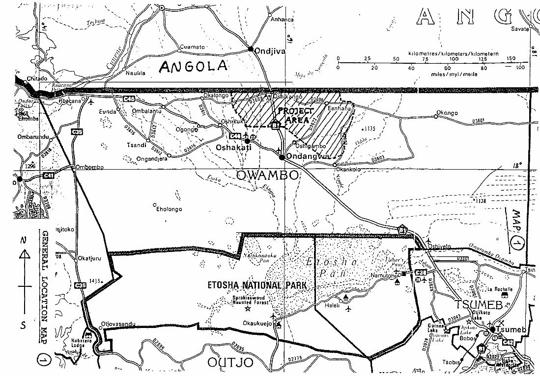
Wind conditions in Ohangwena region are rather calm for most of the year. Strong windsoccur usually only before and during thunderstroms in the rainy season. Easterly andnortheasterly winds are common during most of the year.
TABLE 1 Longterm Monthly Mean ValuesRainfall At Ondangwa
Of Temperature, Relative Humidity And
MONTFI MEAN MONThLYTEMPERATURES
CMAX. MIN. MEAN
RELATIVEHUMIDITY
AT 14 H
MEANMONThLYRAINFALL
MM
JulyAugustSeptemberOctoberNovemberDecemberJanuaryFebruaryMarchAprilMayJune
264 8.3 17.5277 10.3 20.033 3 13.8 23.534 4 17.4 25.933 1 18.7 25933. 1 19.0 26 131.5 19.3 25.430.6 19.1 24.830.1 18.8 24.530.2 16.3 23.3289 120 20.4266 89 17.7
23%19%17 %21 %32%34 %44%48%50%39 %26%24%
013
124376
1051129136
71
Mean annual rainfall is 487 mm.
Evaporation is very high due to strong solar radiation, low humidity and rather hightemperatures. Mean annual evaporation measured from an open water surface atOndangwa is as much as 2 485 mm, about 5 times as much as mean annual rainfall. Somerecent studies indicate that up to 83 % of all precipitation evaporates soon after it hasfallen. Since about 14 % of total precipitation is returned to the athmosphere by plantsthrough evapotranspiration and some water moves to ponds, pans and oshanas, onlyabout 1-2 % of rainfall recharges groundwater resources (Figure 2). Local variations mayhowever be significant, depending on topography, vegetation and soil sonditions.
Athmospheric humidity in Ohangwena is low most of the year. Mean monthly values ofrelative humidity range from about 17 % in September to about 50 % in March.
FINNCONSUL rOy 8


mm120
100
80
60
40
20
0
~ZoM: ~ ~
SIISI~oAJ6&’1 /fl7_
oc40
Fig. 1.Average monthlyrainfall, andmaximum andminimumtemperatures inOndaizgwa
Rainfall1902—1975,temperatures1944—1975
Jan Feb Mar Apr May Jun Jui Aug Sep Oct Nov Dec
:•:~-e±~:•
FIGURE 2~. D(AGRAII Op ~1vA1tR. 6ALAI’)C.E (D(A~iA)

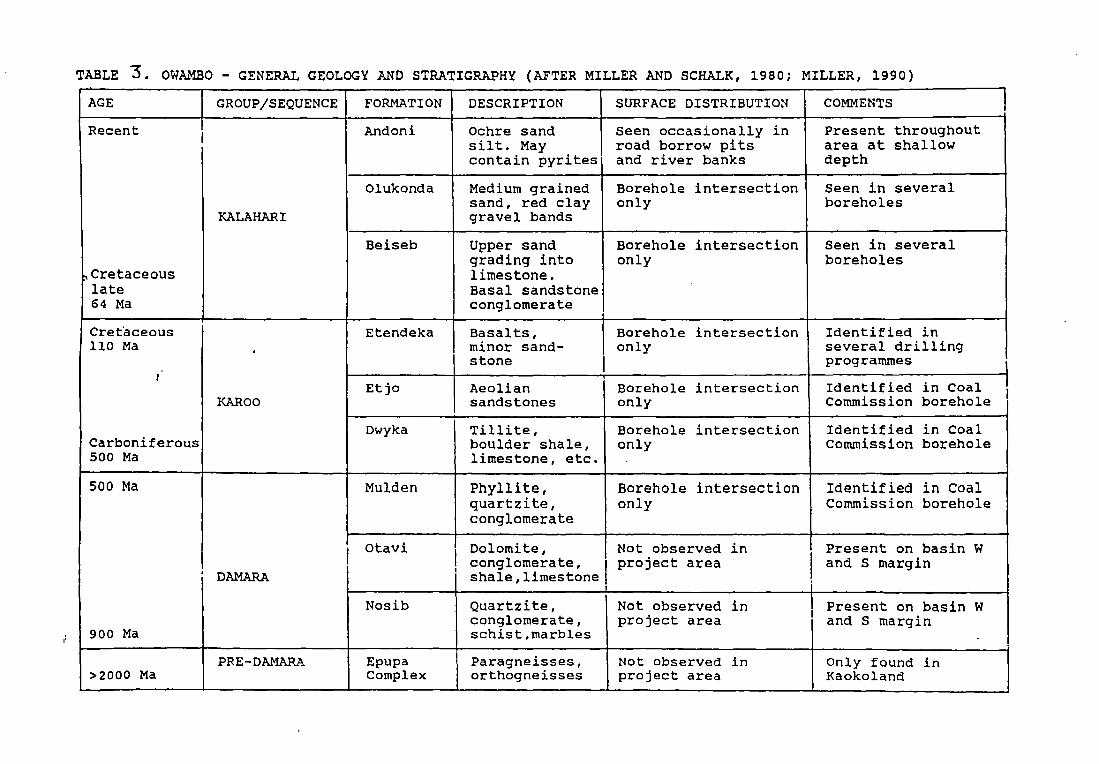
TABLE 3. OWAMBO - GENERALGEOLOGYAND STRATIGRAPHY (AFTER MILLER AND SCHALK, 1980; MILLER, 1990)
AGE GROUP/SEQUENCE FORMATION DESCRIPTION SURFACE DISTRIBUTION COMMENTS
Recent
Cretaceouslate64 Ma
KALAHAPI
Andoni Ochre sandsilt. Maycontain pyrites
Seen occasionally inroad borrow pitsand river banks
Present throughoutarea at shallowdepth
Olukonda Medium grainedsand, red claygravel bands
Borehole intersectiononly
Seen in severalboreholes
Beiseb Upper sandgrading intolimestone.Basal sandstoneconglomerate
Borehole intersectiononly
Seen in severalboreholes
Cretaceous110 Ma
,
Carboniferous500 Ma
•
KARO0
Etendeka Basalts,minor sand-stone
Borehole intersectiononly
Identified inseveral drillingprogrammes
Etjo Aeoliansandstones
Borehole intersectiononly
Identified in CoalCommission borehole
Dwyka Tillite,boulder shale,limestone, etc.
Borehole intersectiononly
Identified in CoalCommission borehole
500 Ma
900 Ma
DAMARA
Mulden Phyllite,quartzite,conglomerate
Borehole intersectiononly
Identified in CoalCommission borehole
Otavi Dolomite,conglomerate,shale,limestone
Not observed inproject area
Present on basin Wand S margin
Nosib Quartzite,conglomerate,schist,rnarbles
Not observed inproject area
Present on basin Wand S margin
>2000 MaPRE-DAMARA Epupa
ComplexParagneisses,orthogneisses
Not observed inproject area
Only found inKaokoland


WATER SUPPLY AND SANITA nON PROJECT IN OHANGVVENA REGION, NAMIBIA Diw T REPORT No 1ENVIRONMENTAL IMPACTASSESSMENT STUDY OCTOBER 1994
The Non-solonetz Soils occur in the western area bordering the Kunene Region and areassociated with calcrete. The soil is typically a brown sandy loam, non-saline, non-sodicand inherently fertile.
Black Clays occur in scattered locations all over Owambo and are associated with thefloors of oshanas and pans. The clays are highly expansive and usually non-saline andnon-sodic, but salinity may increase with depth.
Two-thirds of the Project Area is covered with aeolian sands. Solonetz soils occur in theremaining third as broad north-south striking strip in the central part of the area. Distributionof soil groups is shown on Map 6.
Agriculturally the soils in Ohangwena region are generally rather poor. The high sandcontent of the soils result in a low water retaining capacity and a low organic mattercontent. Other deficiencies include a low content of nitrogen, calcium, potassium andphosphorus. Micro-nutrients such as manganese, iron, and zinc are also in inadequatesupply, and it has been suggested that the lack of molybdenum in the region’s soils couldresult in a soil toxicity situation with excessive use of nitrate fertilizers
Low-lying ground in oshanas is generally too saline for crop production. The low relief ofthe region, coupled with a clay content in the oshanas, tends to slow down watermovement and increase its residence time. When the drainage of arid region soils isimpeded and the surface evaporation excessive, soluble salts accumulate on the surfacehorizon. These soluble salts, if in a high enough concentration, interfere with the growth ofmost plants by encouraging the plant to give off water from its own structure to the soil.
4.4 Surface Water Resources and Drainage System
Within Ohangwena Region there are no permanent nvers or lakes. The water resourcesavailable for the inhabitants and their livestock are the following:
a) Rainfall during the rainy season. Rainwater can be collected from roofs and surfacecatchment areas into reservoirs and ponds.
b) Surface water which flows during the rainy season in ephemeral rivers and oshanasand collects in natural pans. This water can be channelled and stored in ponds andreservoirs.
C) Groundwater in different types of aquifers. Many of the aquifers in Ohangwenaregion contain however saline water, which is unsuitable for human consumptionwithout removal of salts.
d) River water transported from Kunene river in Angola by means of canals andpipelines to major settlements in Omusati, Ohangwena, Oshana and Oshikotoregions.
FINNCONSULT Ov 12


lome Ires
LAKE AREA*EASTERN AREA4 I
-‘ ~ vs
- b4tr~
S.,
-—---1~--—-____________ .,~e”
_~
\ ‘~
/. .~~2.t”-”.
~ (55. r’• ~ - /
— .. Major groundwater areasin DamaraSequence
MAP 6. MAJORGROUNDWATER AREAS AND SIMPLIFIED SOILKalahari Sequence Aquifersnot plotted DiSTRIBUTION
DI LJflO
10S4
ib~
Legend [~]1 Acolian sands
2 Solonetz soils
[~]1 +2 Mixed aeolian sandsand solonetz soils
C. 3 1 U 10


Division of the major drainage systems in Owambo intodifferent zones. Eastern dormant drainages flowinfrequently and only under exceptional circumstances. Thewestern and central oshanas flow more frequently, but onlythe central oshanas have perennial headwaters in Angola.With sufficient rain, which falls only occasionally, waterflows into the Etosha Pan from the entire system.
MAP 7 THE CUVELAI DRAINAGE SYSTEM IN SOUT~!ERNANGOLAAND OWM~BO
From: Marsh & Seely (editors), 1992.
0.


WA TER SUPPL YAND SANITATION PROJECT IN OHANGWENA REGION, NAMIBIA D~FT REPORTNo. IENVIRONMENTAL IMPACTASSESSMENT STUDY OCTOBER 1994
The western part of Ohangwena region belongs to the Cuvelai floodplain or inland delta,a drainage system of seasonal rivers and oshanas, which originates from the SierraEncoco highlands in Southern Angola, where mean annual rainfall exceeds 1 000 mm. TheCuvelai drainage system is a part of Etosha basin and it ends up in the huge Etoshasaltpan some 80 km south of Ondangwa. At Etosha mean annual rainfall is about 430 mm.
The Cuvelai delta is about 70 km wide at the Angolan border, and then graduallyconverges towards the Etosha pan. The total catchment of the Cuvelai system coversapproximately 40 000 km2. (See map 7).
Oshanas are shallow, vegetated, interconnected channels and pans, lying in a valley ofvery low gradient, in which water accumulates, moves and/or stands depending on theamount ofwater present in any one season. There is no well-defined flood channel and thevelocity of water rarely exceed 0.5 m/s. The banks of oshanas are lined with trees andbushes.
The term efundja refers to floods in the oshana system that occur when good rains havefallen over the whole catchment area of the Cuvelai. From usage among the localpopulation it appears to refer only to large floods originating in Angola, and not to localisedrains and small-scale floods.
Water flow in the oshanas and seasonal rivers differs from year to year and place to place.When southern Angola receives abundant rainfall the central oshanas may flow strongly forseveral months, possible even as far as Etosha pan. It has been estimated that a once-in-fifty-years flood in the central oshana zone with perennial headwaters would have amagnitude of up to 1 490 m3 per second. The seasonal flood (efundja) does however notevery year spill over from Angola to Namibia.
Strong local rainfall over the western or central oshanas may also cause water flow withinthe oshana system, sometimes even moving in a northerly direction. Local rainfall appearsto be responsible for any water flow and ponding in the dormant eastern drainages. Theseold channels are nowfilled with sand, are vegetated and have only occasionally flowed thiscentury. It is expected that under present climatic conditions they would probably only flowduring an exceptionally high rainfall event Oshana water flow and direct rainfall bothcontribute to shallow groundwater recharge.
During 38 years of monitoring there have been 4 years with large floods, 20 years withvariable floods and 14 years with no flood at all. During March-April 1994 the flood in thecentral oshana system was rather strong.
1~.
FINNCONSULT OY 14


WATER SUPPLYAND SAN/TA TIGN PROJECT IN OHANG~NAREGION, NAMIBIA DRAFT REPORTNo. IENViRONMENTAL IMPACTASSESSMENT STUDY OCTOBER 1994
4.3 Geology and Soils
The whole project area is situated in the Kalahari group geological formation, which isfloored by mid-Proterozoic crustal rocks of the Congo craton. The formation containspossibly as much as 8 600 m of sedimentary rocks of the Proterozoic Damara sequence,some 360 m of Karoo rocks and about 130 m of cretaceous rocks overlain by a blanket ofunconsolidated Kalahari sequence sediments up to 600 m thick. The successive layers ofsands, sandy clay, sandstones and conglomerates of the Kalahan group are up to 500thick and of Tertiary to Quatemary age (30-40 million years). Kalahari sandstones can beseen everywhere in the bottoms of wells, borrow pits and water reservoirs.
The Andoni formation in the upper portion of the Kalahan sequence is the mostwidespread Kalahan formation comprising of interbedded white medium-grained semi-consolidated sand, light green clayey sand and green clay. The sand occurs in bands 10-200 m thick, and can be slightly pyntic or haematitic. Calcrete and dolcrete occur in nodularform, locally as mature consolidated sheets. The entire sequence is discontinuouslycovered in upper Kalahan windblown sand and alluviums, forming dunes to the east andpans and interfiuves to the west. General geology and stratigraphy is presented in table 3.
The common parent material of the alluvial plain in the region is a remarkably uniform,relatively unweathered, medium-textured sand. The soils of Ohangwena region can broadlybe classified into four groups:
1 Aeolian sands (arenosols)2 Solonetz soil3 Non-solonetz soils4 Black clays
The aeolian sands or arenosols are present on the fringe of the central alluvialdepression. The clay contents is relatively low, varying between 2 % and 8 %. These soilsare also generally non-saline. Although much more complex in distribution andclassification, it can generally be stated that grey sands cover the whole of the easternarea, while red and brown sands are characteristic in the gentle relief of the western areaof Owambo. There are also sands, enriched with locally derived material, in narrow lensesin the higher lying areas between the oshanas.
The solonetz soils are medium textured alcaline soils with an essentially sandy structure.They cover virtually the whole central alluvial plain and are charactenzed by a bleached(white) surface. There is also a definite transition between an upper and a lower, morecompacted, solonetz horizon having lower permeability and high sodium activity. Thisprofile is typical of soils in flat areas with saline parent material and poor drainage. Theupper layers of these soils are shallow, but cultivation is practiced on higher lying areasbetween the oshanas.
FINNCONSULT DY 10


WATER SUPPLY AND SANITA TION PROJECT IN OHANGWENA REGION, NAMIBIA DRAFT REPORT No IENVIRONMENTAL IMPACTASSESSMENT STUDY OCTOBER 1994
The most prominent oshanas of the Cuvelal are the Oshana Gwashuui which pasesOgongo, the Oshana Shalupumbu which runs past Okalongo, the Oshana Cuvelaipassing Oshakati and the Oshana Oshigambe at Oshigambo. Run-off in the OshanaEtaka mainly originates from local rainfall and its watershed lies just to the east of Eunda.The northerly course, known as the Oshana Olushandja, drains towards the KuneneRiver and the southeasterly course runs into Lake Oponono. From Lake Oponono thewater of the Cuvelal and the Etaka is carried by the Oshana Ekuma into the Etosha Pan.The most significant oshana in the northeast is the Oshana Odila. An extensive zone ofpermanent sand dunes is found in the southeastern area and dry water courses occur inthe roughs between the dunes. The raemaining part of this area is dotted with numeroussmall pans and little run off occurs, even after heavy rainfall.
The oshana system covers the western two thirds of the project area. The eastern portioncontains only one large oshana, the Oshigambe.
The seasonal flood in the Cuvelai system is very important for the rural economy inOhangwena region. Fresh surface water, naturally or artificially collected in pans andoshanas, provides high quality water for rural households until it evaporates. Thefloodwaters also recharge groundwater, bring in fish, which is an important source ofprotein for the inhabitants, and regenerate grazing for livestock.
Disturbances to the flow of water in the oshana system have since the 1970’s been createdby infrastructure developments both in southern Angola and northern Namibia. Especiallyconstruction of roads and canals with raised embankments across the oshana system hasto some extent changed and prevented the free flow of water in the oshanas.
Utilization of the run-off in the oshanas is done by constructing dams, ponds andpumped storage reservoirs. The depth of excavation dams is limited by local saline watertables, which in some areas may be as shaflow as 3 m below ground. Excessiveevaporation from large shallow reservoirs is a significant problem, which has in somecases been tackled by introducing pumped storage dams with high embankments whichincreases water depth in the reservoir. Most of these earlier structures have unfortunatelybecome unoperational due to siltation and lack of maintenance.
Many ponds and surface-water reservoirs have later been created from borrow-pitsexcavated during construction of roads in the 1970’s and 1980’s. These ponds are muchused for livestock watenng, but for human consumption well water or piped water ispreferred.
The natural condition of surface waters in the oshanas is usually rather good and does notpose either biological or bactenological problems. However, contamination of standingwater occurs due to inadequate human sanitation and by contamination from livestock.
FINNCONSULT OY 16

/
/

WATER SUPPLY AND SANITATION PROJECT IN OHANGWENA REGION, NAMIBIA DRAFT REPORTNo IENWRONMENTAL IMPACTASSESSMENT Sruoy OCTOBER 1994
Bulk water supply from Kunene river
The only perennial surface water source available for inhabitants in Ovambo is theKunene river, which flows from southern Angola to the Namibian border at Ruacana fallsand then along the border to the Atlantic Ocean. An agreement signed in 1926 between thegovernments of Portugal and South Africa allows the Namibian government to abstractfrom Kunene river a maximum of 6 m3 per second. Present pumping capability at Kuneneriver is far less than the agreed upper limit.
An extensive scheme of canals, pipelines, storage dams, pumping stations, waterpurification plants and reservoirs has been established since the 1960’s to supply majorsettlements in Owambo with perennial water from Kunene river. This bulk water supplynetwork is the largest water supply system in the country. At present it consists of 29pumpstations, 92 km of canals, 950 km of pipelines and 9 purification plants.
A part of this scheme is the Ondangwa-Oshikango State Water Scheme, also known asthe Herringbone Scheme, which is located within the WSSPOR project area. The lengthof the Herringbone Scheme is at present about 230 km, and it supplies about 43 000inhabitants (12 000 at growth points and 31 000 in rural areas) Its main bulk water supplyartery runs from Ondangwa in the south to Oshikango at the Angolan border. Branch linesreach to the western and eastern sides of this main artery. At present a new pipeline fromOmafo to Eenhana (48 km) is under construction with financial assistance from France,and the Omakango-Onambutu pipeline is under upgrading.
The availability of permanent water provided by the state water scheme has stronglyinfluenced the settlement and land-use patterns of the area. Concentration of people andlivestock to levels that exceed the carrying capacity of the land has taken place in manyareas along the scheme. Further land degradation can be prevented onlly if effective land-use planning and control as well as improved livestock management and control ofstocking rates is introduced A comprehensive overall land-use plan should form the basisfor future planning of extensions to the bulk water supply scheme.
FINNCONSUL TOY 17


Nkonqo
OmytwewontmaI• __
~Osl’uveIo _______
Map showing existing and proposedpipelines and canals.
Cclueque
CIflo
Oshikongo OdthoANGOLA
OWAMBO-o
In
—1
0
0
fri
1~
Oihgombo
~0cr1r
a0
0
Oniombo
N
Omuntele
NN
LEGEND
Exlstinq pipelines
— — — Canals—. Proposed pipelines untIl 1995
Pipeline under construction
0 PurIfication Works
-c-i


schematiclay-outof theHerringbonesystem
—I
(183001
(Z0000l . .1
IA’(z0000j I
~I3OoO) II
Ab00o01 I
A osIIIr_LJ,co. IiUcooj
I
I
IA(2.34001
.J
OKATANIi.
tilool
0~0A3ICvL
(10)
o~zowunj013001
OSIIICLUOO(Z3iooi
00100
0IwlcWo1~131300)
\(13163J\
Planning area’
1(601003
Symbol Capacity of DescriptionComponont and Unita
Am3/a
m3
rn3/a
rn3/h
m3
Consumer
Pumped storage dam
Pipeline
Pumping station
Clear waterreservoir
FIGOR~ 3. .SCH6MAT1C- j..,jyouT OF Th~ ~~gA1AJGSO~
w~-r~-SUPPLy SYSTCM
C’. -


WATER SUI’pL YAND SANITATION PROJECT IN OHANGWEN4 REGION, NAMIBIA DRAFTENVIRONMENTAL IMPACTASSESSMENT STUDY C
4.5 Groundwater Resources
The Cuvetal basin drainage system is underlain by a large deep aquifer (DA) with salinewater, the underground “Brine lake”, which has its origin in Lake Etosha, a large salinelake which existed still some 35 000 years ago. During its largest extent about 3 millionyears ago, lake Etosha covered an area of about 70 000 km2 (about the size of present-day Lake Victoria in east Africa), and reached up to the present 1 120 m countour line.Maximum depth of the lake was about 40 m. Since the lake did not have an outlet to thesea, evaporation caused gradually salinity to rise. Progressively also the sediments underthe lake floor became salinized.
The saline brine lake area is more or less confined to the Etosha depression, which coversthe western part of the project area. The deep saline aquifer occurs below a depth of 50 m,and generally salinity increases with depth. Salinity levels in excess of 10 000 mg TDSIIhave been measured from numerous boreholes. Such water cannot be used for humanand livestock consumption without desalination.
The borderline of the eastern area where fresh deep groundwater can be found runsapproximately from a point about 20 km east of Oshikango at the Angolan border insoutheasterly direction passing east of Ondobe and Okankolo. The majority of theinhabitants within the project area live within the brine lake area with saline deepgroundwater.
Two types of shallow aquifers lying above the saline brine lake aquifer have been identifiedin the western part of the project area:
a) Main shallow aquifer (MSA), and
b) Discontinuous perched aquifer (DPA).
These aquifers are the main sources of potable gorundwater in central Owambo. Bothdepend exclusively on annual recharge from rainfall and rainwater collecting in oshanasand pans. Figure 4 illustrates the location of different aquifers.
FINNCONSULT DY 21


u-.-3
0
k0
3~)a
03
II
U)
U-
0
—
‘If0
00
0
0
0
U,
U)
U)
-J
-J
“l
z
0
~ U)•- U)
F~oM M~&~H‘& ~eGL..~j (LI.) , (1’i’z~
02
2


WA TER SUPPLY AND SANITATION PROJECT IN QHANGWENA REGION, NAMI8IA DRAFT REPORTNo IENVIRONMENTAL IMPACTASSESSMENTSTUDY OCTOBER 1994
The MSA is located within the Kalahari sandstones at depths of 10-30 m. Water istraditionally tapped by hand-dug wells (ndungus) equipped with handpumps orwindlasses.MSA water quality vanes from drinkable to highly saline.
The DPA is an ephemeral or seasonal water source, located mainly in association withcalcrete layers in or close to oshanas and pans, at depths of less than 15 m. The depth ofthe potable water body seldom exceeds 40 cm. During the dry season water levels dropconsiderably, and many of the wells and waterholes tapping the DPA source dry up. Thetraditional waterholes are shallow hand-dug conical pits known as omafima, whichcommonly serve only one or a few families. New omafima are usually dug every year lfloshana beds and pans during the dry season. Fig trees are often indicators of thepresence of a shallow perched aquifer.
The Eastern area
In the sparsely populated eastern part of the project area, east of the brine lake area, freshgroundwater can be found at depths of 70 to 100 m. About 85 % of the boreholes that havebeen drilled in the area, have been successful. Due to the depth of the water table wellsand boreholes have to be equipped with windmills, diesel driven pumps or solar powerpumps, which Increases the cost of water significantly. Extensive geohydrologicalinvestigations and drilling tests are required before any conclusions can be made on theavailability of fresh groundwater to sustain large scale urban and/or rural development.
4.6 Vegetation and Wildlife
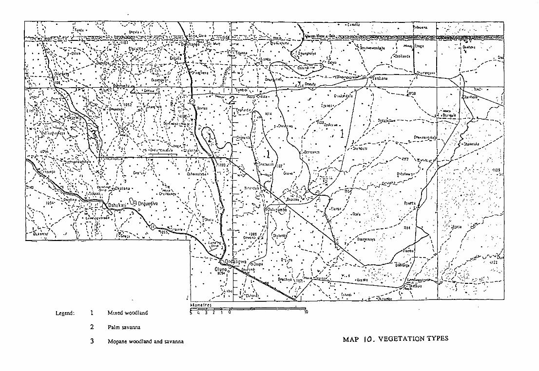
The types of natural vegetation found in Ohangwena region are associated with smallchanges in topography, rainfall, drainage pattern and soils. Common vegetation types canbe broadly classified into following 5 assemblages:
a) Mixed dry woodland and forest
b) Palm and marula savanna
c) Mopane woodland and savanna
d) Mopane-acacia shrub savanna
e) Open grassland
r.
FINNCONSULT OY 23

I— _:,I’ - --
• I. %~. • G~fe~c~r.~
•.‘. •~‘‘ ~:‘~:~• ~~•‘h
1 ~
IO~2 •
, . ‘. .‘./..\ ‘_. •
I \ ~ ~
.1 ç. . ~• .~~ *
‘I. ‘I
>.~*• -. ~.I ~,• .,— • CIIII~~•~. II~ C~, •~• .--“ ~- ‘-~-‘. I •~- . • I’
• l~ ‘,‘ ~\_• -, . • . .: •.‘ •~ ~ / . . •~~\ / ~ . .\
~- ~2’~ ~~~~Qk3lana • . • •
,On~ue~a:~ • •
i•~
Legend~ 1 Mtxed woodland S~L. 3 2 0
2 Palmsavanna
MAP tO. VEGETATION TYPES
I ~ ~‘
- •~t~d8~
— Yi~i~F
:;~“ I ‘N
~ I- ~
- (~J ~f ~ / ;2~-‘ - -‘
I ~ • - c~r-’rtIrf
~~1/ 1~-~’r~-- / \~. I,— - - ~~r-’~
TTT
I” I - :~.
~u~f
~ - - -
-, ~I?L.nth - ,___—~ (. \
i. Ct~uu~~- ________________
‘.~. I
— ~,_ 1 ,
- -r
-;•,--
-‘--c 7,,, ‘I
I ~-~c~-~~‘T-
- ,,~---.1. kf ~‘~~/*‘, :-~:- -
‘-1 -_.,,
k~ometres
3 Mopa.newoodlandand savanna


WATERSUPPLY AND SANITA ~7ONPROJECT IN OHmG~ENAREGION, NAMIB1A DRAFTREPORT No IENVIRONMENTAL IMPACTASSESSMENTSTUDV 0croo~R 1994
Mixed dry woodland and forest, associated with deep aeolian sands occupy the easternarea east of the Cuvelai drainage basin and extends into Okavango region. The trees growhigher and denser eastwards where rainfall slightly increases. The woodlands contain alarge variety of deciduous trees, with vaalboom, cameithom (Acacia erioloba) and wildseringa as the main species.
Also rather common species are kiaat or wild teak (Pterocarpus anpolensis), manketti tree(Ricinodendron rautanenil), Combretum species and Terminalia sericea. Other importantspecies include Zambezi teak (Bailcea plurijuga), copalwood (Guibourtia coleosperma) andtamboti (Spirostachus africana). Grass cover is moderate, but in the eastern area grassestend to be less palatable than elsewhere.
The eastern dry woodland and forest areas are still sparsely populated due to water supplydifficulties, and also because of insecurity and military activity in the area dunng theliberation war in the 1970’s and 1980’s. Increasing population pressure in the denselypopulated western areas has however recently created a migration into the eastern parts ofOhangwena, and the remaining woodlands are becoming seriously threatened. Alsoincreasing demand for fuelwood and poles for fencing and house construction has becomea threat to the woodlands. Especially endangered by increasing logging and woodcuttingare valuable construction and pole woods, such as Zambezi teak and kiaat. Much of thepresent logging activities are illegal. As long as effective control systems do not exist,illegal cutting will continue and increase.
The western parts of Ohangwena region, which belong to the Cuvelai drainage basin,are densely populated, and natural vegetation has been much altered by human activityand livestock. Some 30-40 years ago there were still many intact woodlands between thesettlements, but now almost the whole area has become a modified agricultural landscapewith clear signs of increasing environmental degradation. The topography is a mosaic oflarge flat grass-covered depressions (oshanas and pans) and slightly raised sandy groundwith farmland, farm compounds, grazing land and scattered trees.
The dominant type of natural vegetation in the western area is palm and marula savanna.Scattered fan palm trees (Hyphaene petersiana), which surround depressions anddrainage lines dominate the landscape visually. Large fruit trees, mainly marula(Scierocerva birrea), sycamore fig (Ficus sycamorus) and baobab (Adansonia digitata),can be seen scattered troughout the landscape. Big termite mounds (Macrotermesmichaelseni and M. natalensis) are often associated with fig and marula trees.
Secondary growth of mopane shrub (Colophospermum mo~ane)and cameithorn (Acaciaenoloba) may also be associated with palm and marula savanna. Grasses are importantcomponents of the sandy more elevated areas. When such land is left ungrazed it maygrow dense stands of tall grasses.
F-
FINNCONSULT Ov 25


WATER SUPPLY AND SANITATION PROJECT IN OHANGWENA REGION, NAMIB1A DRAFT REPORT No IENVIRONMENTAL IMPACTASSESSMENT STUDY OCTO8ER 1994
The mopane woodland and savanna vegetation group is associated with solonet.z soilsand is characteristic of the central and northwestern parts of the Cuvelai drainage basinextending across the Etaka. Marula, palms, baobab, and manketti trees commonly grow inisolated communities within mopane woodland. Sometimes also Acacia species, Africanebony (Diospyros mespiliformis), and Terminalia sericea may be found in mopane savannaand woodland.
These areas have to a large extent been denuded of natural vegetation, except importantfruit trees, due to extensive use of mopane timber and branches for palisades, fencing,house construction and firewood, and due to clearing of the land for cultivation and grazingland. Grass cover is moderate, consisting of vanous perennial and annual grasses. In well-developed mopane stands grass is usually scarce, which may be due to the very denseand shallow root system of mopane trees.
Mopane-acacia shrub savanna occurs in the south-central parts of Owambo on salineground close to the Etosha pan, but can also be found elsewhere on the fringes of oshanasand pans. Halophytic vegetation dominates and Acacia newbrownii sometimes forms thickstands.
Open grassland is abundant in the western parts of Ohangwena region, especially onseasonally flooded land on the edges of oshanas and pans. Flooding of these areas, fromlocal rainfall or more distant sources, contributes nutrients and water and thus stimulatesgrass growth. These areas are widely used as communal grazing lands and represent animportant element of the farming system. Towards the end of the dry season most of thegrass has been grazed and trampled down to very short stubble.
Most of the trees that grow scattered on farmland and grazing land are preserved due tocertain valuable products (fruits, pods, leaves, branches etc.) that are continuouslyharvested. This system is a kind of traditional agroforestry practice, although trees are notactively planted and regenerated. These trees and products include the following:
Baobab Fruit and leaves used as livestock fodder.Fruit and bark has also medicinal use. Fibers used for rope and mattingetc.
Bird plum or Fruits are edible and much valued.brown ivory (Omuye)
Cameithorn Pods are valuable livestock fodder. Branches used as firewood andimplements. Bark has medicinal use.
Fan palm Sap has been used for palm wine, but since(Makalani) sapping easily kills the tree, the practice has been forbidden.
Fronds used as fencing material, for basketry and as firewood.Natural regeneration of palms is rather strong.
Manketti Fruits and kernels are edible. Kernels are rich in protein and givehigh quality food oil. Leaves have medicinal use
F!NNCONSULT DY 26


WATER SUPPLYAND SANITATION PRO.JECr IN OHANGWENA REGION, NAMIBIA Dswr REPORTNo. IENVIRONMENTAL IMPAcTAsSEsSMENT Sruov Ocroa~R1994
Marula Fruits are highly valued. Used for food and brewery, kernels forfood oil. One mature tree can yield 0,4-1 ,6 tons of fruits annually.
Mopane Branches are used as fencing and house construction poles andfirewood. Leaves can be used as livestock fodder. Mopane hasgood coppicing vigour.
Sycamore fig Fruits are edible and good livestock fodder.
(Omukwiyu) Leaves, bark and roots have medicinal uses.
Some characteristics of most common trees in Ohangwena region are presented in table 4.
Wildlife
The eastern forests and woodlands are the main habitats for wildlife in Ohangwena region.Large wild mammals have become almost extinct during the last 40-50 years. This is dueboth to increased hunting as well as disturbances in the area during the liberation war inthe 1970’s and 1980’s. Small numbers of antelopes (e.g. bushbuck, eland, gemsbok,greater kudu and wildebeest), springbok, baboons, hyenas, jackals, leopards and warthogscan occasionaly be seen in remote locations in the woodlands, and sometimes alsooccasional wide-ranging elephants visiting from the woodlands of southern Angola, whichare more endowed with wildlife.
Many species of large mammals, which were common in Owambo still in the 1 950s, cannow be found only in the Etosha National Park, which is located some 80 km south ofOndangwa. Etosha is considered to be one of the most important game parks in SouthernAfrica. It covers about 22 270 km2, stretching about 280 km in a 60-100 km wide belt fromOtjovasandu in the west to Oshivelo in the east.
As much as 98 species of reptiles have been identified in Owambo as well as 16 species ofamphibians and 94 species of small mammats, including hares, honey badgers, mongoose,porcupines, hedgehogs, tree squirrels and ground squirrels, rats, mice, shrews, pangolinsetc. Hares and squirrels are commonly hunted, and frogs are an important component ofpeople’s diet during the wet season. Rodents and other vermin associated with humanhabitation are very common.
Totally as much as 411 species of birds have been recorded in Owambo. The Cuvelaibasin drainage system supports a rich diversity of birdlife, particularly wetland species.These include also rare or endangered species, e.g. Wattled crane. Some of the birdspecies are hunted by shepherd boys with slungs and arrows for food
FINNCONSULT OY 27


1A~LE ~1 PRINCIPAL CHARACTERISTICS OF MOST COMMON TREES IN THE STUDY AREA
Scientific name* Local name~ Family* Protected Growth~Drought~ Potential utilizations “and~~ Comments~and
Acacla erloloba - Mimosoldeae Y
.
S XXX
Firewood F~d~ërF6~5Z Medica[~Wood
Tolerates saline soilsXXX X XXX X XBaphia massalensis Ofufe Papillonoideae N - - - - - - On Kalahati sandsBaikiaea plunjuga Omupapa Caesalpinioideae Y • - - - - XXX Withstands abrasionBauhinia macrantha Omutwanghutu Caesalpinioideae N - - - • - X -
Berchernia discolor Omuve Rhamnacae y S XX X X X XX Resists termitesBoscia albitrunca Omunghudi Capparaceae V S XXX X XXX X X X Tolerates saline saltsBurkea africana Omutundungu Caesalpinioideae Y S XX XX X X Host for eadable wormsCQ~ophospermummopane Omufyati Caesatplnioideae Y S XXX XXX XXX X X Host for eadable wormsCbmbretum imberbe Omukuku Combretaceae Y S XX XXX X X Resists termitsCombretum mechowianum Omupupwaheke Combretaceae N - - - - - -
Commiphora africana - Burseraceae N • - X X)(X X X X Good InsectcideDichrostachys cinerea Ongete Mimosoldeae N S XX XXX XXX X)C< X X Resists termitesDiospyros lycioides Oshimumu Ebenaceae N S XXX X Tolerates saline soilsDiospycos mespiliformis Omwandi Ebenaceae N S X X X X X Resists termitesFicus sycomarus L. Omukuyu Moraceae V S X X X X X Resists termitesHyphaerle ventricosa Omulunga Arecaceae N - - - - XX -
Lonchocarpus nelsil Omupancia Papilionoideae V - - - XXX - •
Peltophorum africanum Omupalala Caesalpinioideae Y I XX XX X X XXPterocarpus angolensis Omuuva Papilionoideae V - S XX XX X XX Resists termitesRicinodendron rautanenii Omunghete Euphorbiaceae V • - X X X On Kalahari sandsSclerocarya birrea - Anacardiaceae V I XX XX XXX XXX X XX Highly nutritius fruitsTerminaliasericea Omwoolo Combretaceae N S XX XXX X X XX Resists termites
Y= YesN= NoS= Slow
I = tntermediate
DraughtX Somewhat susceptibleXX Moderatly resistant
XXX Very resistantBlanc: Susceptible
Utilizations (except medical):X ~-XXXIncreasing ImportanceBlanc: no utilization
Medical:Blanc: no utilizationX: used
When there is a -• it means that no data were available
• A. ERKKILA and H SIISKONEN (1992) P.J. LE ROUX (1971)-- K.C PALGRAVE (1983) “.“ B.H.C.TURVEY et at (1977)
R J. POYNTON (1973) ““D. ROCHELEAU et al. (1988)
r


WATER SUPI’I. Y AND SANITATION PROJECT IN OHANGWENA REGION, NAMIBIA DRAFT REPORT No IENViRONMENTAL IMPACTASSESSMENT STUDY 0cron~R1994
The fish life in seasonal oshanas and pans is similar to sump lakes in other parts ofsouthern Africa. It is dominated by 3 genera: Barbus, Clanas and Oreochromis. 17 fishspecies have been recorded in the permanent headwaters of Cuvelai river in Angola.Large amounts of fish enter the oshanas in those periods when strong efundjas spill overfrom Angola to Owambo. Fishing is an important activity during flood periods. Fish arecaught with nets and baskets arranged in openings of small earth and brushwood damsbuilt across flooding oshanas.
Development of small-scale fish farming in dams and ponds has much potential and shouldbe encouraged.
4.7 Population, Human Settlements and Infrastructure
Total population in Ohangwena region is at present about 180 000, and average populationin the project area is about 125 000. The western part, to the west of the Ondobe-Oshigambo line is densely populated, with population densities between 25 and 100persorislkm2. The highest density, around 100 persons/km2, is found along theOndangwa-Oshikango-Angola trunk road in a strip extending some 5 km on both sides ofthe road. This area includes the following growth centers: Omakango, Okatope,Ohangwena, Omafo, Engela and Oshikango Other growth centers in the western area areEndola. Omungwelume, Onganga and Ondobe. The eastern part of the project area ismuch more sparsely populated, with densities mainly below 10 persons/km2. Main growthcenters are Oshandi, Eenhana and Onambutu
(Density figures different in Prodoc and Draft Water Supply Development Plan.)
Most of the inhabitants in the project area live in rural areas (113 000), and only about11 % (11 700) in semi-urban centres. Population growth is at present fairly high, more than3 % annually. Estimated total population in year 2005 is between 164 300 and 184 500.The majority of the inhabitants of the project area belong to the Kwanyama languagegroup of Owambo people. Minority groups are Mbalantu, Kwambi, Ndonga and Kwaluudhi.
About 57 % of the population in Ohangwena are less than 19 years of age. Only about34 % are in the working age group from 20 to 59 years and about 9 % are above 60 years.Women are in the majority in all age groups (53 % of total population), but in the age-group20-59 they constitute as much as 64 %. This is explained by labour migration to other partsof Namibia. A considerable part of the male population in Ohangwena region travels tomining areas, commercial farming areas and industrial centres in order to look for cashincome.
FINNCONSULT 0V 29


WATER SUPPLYAND S~.ivITATION PROJECT IN OHANGV~NAREGION, NAMIBIAENVIRONMENTAL IMPACTASSESSMENT STUDY
D~FTREPORT No. IOCTOBER 1994
Infrastructure developments in Owambo during the 1970’s and 1980’s created aninternal migration towards those areas provided with roads, water supply, electricity andcommunity facilities. A rapid population growth started along the main development axisOshakati-Ongwediva-Ondangwa to the south of the project area and in the area ofOmakango-Ohengwena-Engela-Oshikango along the Ondangwa-Oshikango main road.The growth of these urban and semi-urban centres continues still. A further growth factorwas the repatriation of Namibians from abroad after independence in 1990. Although someamount of employment opportunities exist within government services as well as trade,small industries and workshops within the growth centres, the majority of inhabitants in theurban and semi-urban areas are also engaged in farming and livestock economy.
Major centres are listed below.
TABLE 5 Major Centres In And Around Ohangwena Region
Place or area Estimatedpopulationin 1990
Status
Oshakati-Ongwediva 65 000 TownOndangwa-Oluna 15 000 TownOniipa 7 000 TownOmafo-Engela * 4 000 Growth pointOhangwena * 3 500 Growth pointNkongo (Okongo) 3 000 Growth pointOshigambo 3 000 Growth pointEenhana * 3 000 TownOshikuku 2 000 Growth pointOkalongo 1 500 VillageOmungwelume * 1 500 VillageOkankolo 1 500 Growth point
Total
* Centres within the project area
109 500
Modem infrastructure in Ohangwena region and its surroundings is concentrated along the2 main roads: Ondangwa-Oshakati-Ogongo-Ombalantu-Ruacana (Route C 46) andOndangwa-Ohangwena-Oshikango (Route B 1). These roads, which were originally builtfor military purposes in the 1970’s and 1980’s are asphalted and in good condition. Goodquality gravel roads within the project area are the following:
- A connection from Ombalantu in the west via Okalongo and Ongenga to Engela and theOndangwa-oshikango main road. This road has also a connection via Endola toOshakati.
- A connection from Omafo eastwards via Oshandi to Eenhana and further to Okongo andOkavango region.
FINNCONSULT Ov 30


WA TER SUPPL V AND SANITATION PROJECT IN OHANGI~NAREGION, NAMIBIA DRAFT REPORT No 1ENVIRONMENTAL IMPACTASSESSMENTSTUDV OCTOBER 1994
- Another connection from Ondangwa-Oshikango main road via Okatope and Ondobe toEenhana.
- A southwestern connection from Eenhana to Oniipa and Ondangwa via Onambutu andOshigambo.
Further transport facilities are provided by airports in Ondangwa and Oshakati, with regularflights to Windhoek. Telephone services are within the project area provided in Oshikango,Engela, Eenhana and Ohangwena.
A main 330 Ky powerline runs from Ruacana Falls Hydropower Plant via Oshakati,Ondangwa and Oshivelo to the rest of the country. Plans exist to extend the network fromOndangwa to Omafo, Engela and Eenhana. At present the main centers within the projectarea have to rely on diesel generators for electricity supply.
Water infrastructure is briefly described in sections 4.4. and 4.5. More data can beobtained from the Regional Water Master Plan for Owambo Region (DWA 1990) andspecific reports listed in Annex 5. Plans and possibilities for future WS development arediscussed in chapters 5 and 6.
4.8 Land-use Patterns and Farming Systems
The agro-pastoralist people of Owambo lived in pre-colonial times on small farms indispersed settlements that formed local “kingdoms”, which were separated from each otherby vast woodlands. During the colonial period settlement patterns were divided by thepolitical border between Angola and Namibia, This border cut straight across the cultural,economical and physiographic units of the region. In recent times the settlement patternhas been rapidly changing due to population growth, rapid urbanization and warfare in the1970’s and 1980’s. The former vast woodlands extending between the different kingdomsand communities have now disappeared from almost the whole of the Cuvelal basin region.
Availability of potable water from ephemeral surface water sources (seasonal flyers,oshanas and pans) and underground aquifers has been the most important environmentalfactor determining settlement patterns and population densities in Owambo. Thus themajority of the people have settled in the Cuvelai basin area, and only few people in theeastern woodlands with deep Kalahari sands.
F!NNCONSULT Ov 31


WATER SUPPLY AND SANITATION PROJECT IN OHANGWENA REGION, NAMIBIA D~FTREPoI~rNo IENVIRONMENTAL IMPACTASSESSMENT STUDY OCTOBER 1994
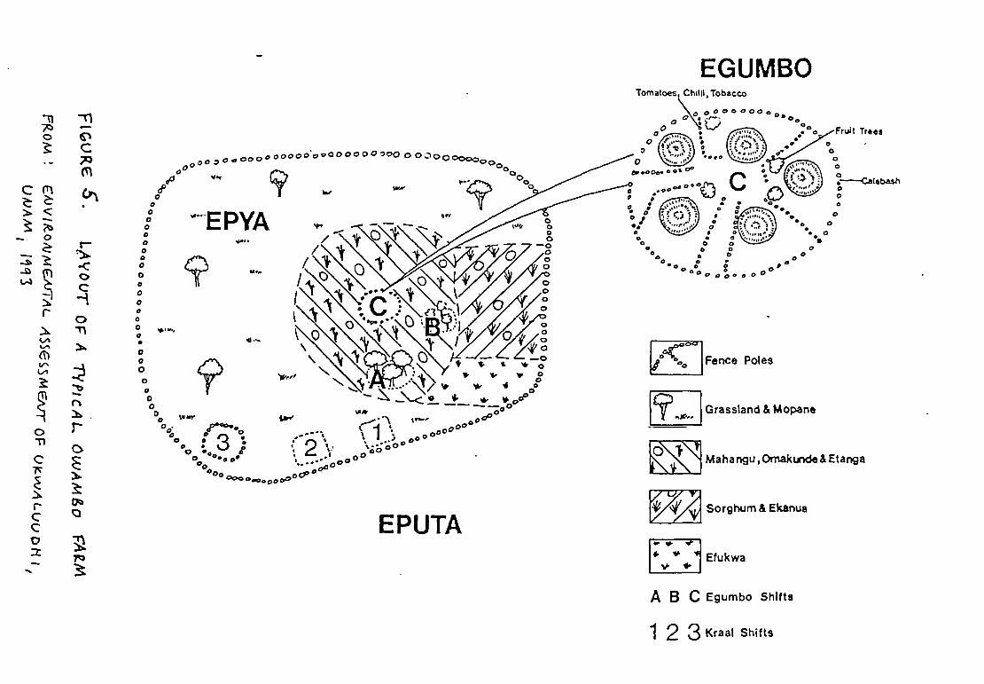
The farms in the Cuvelai area are usually 2-5 hectares in size, situated on higher groundsurrounded by grazing land, and often separated by oshanas and pans. Important fruittrees, such as marula, fan palm, manketti, baobab, sycamore fig etc. are scattered over thelandscape, growing on farmland and on the edges of oshanas and pans. Cultivated landsare usually surrounded by fences made from poles, branches, brushwood and sometimesfencing wire.
The fenced farmland is called the epya and the surrounding communal grazing land theeputa. Fencing of the whole farmland, not only the homestead, became common duringthe wartime, when South African military vehicles used to drive on cultivated fields.Owambo farmers tried to protect their fields by fencing, and this habit seems to continueeven after the re-establishment of peace.
Within the fenced epya farmland lies the family homestead, the egumbo. Traditionally theegumbo is surrounded by a high palisade of closely standing poles of mopane, terminaliaor kiaat. Internally the egumbo may be further divided by smaller palisades forming closedcourtyards around small round houses with thatched conical roofs and walls made of polesand branches plastered with clay. The traditional way of building fences and homesteadsconsumes enormous amounts of pole wood. A medium-size farm may consume more than7 000 poles of different sizes. The lifetime of good quality termite resistant poles (mainlymopane and terminalia) is usually 6-8 years. A typical layout of a farm in Owambo ispresented in Figure 5.
Introduction of wood-saving methods of fencing and viable substitutes to traditional fencingand construction materials is an urgent task if remaining forests and woodlands are to besaved from total destruction.
FINNCONSULT O~ 32

EGUMBO
00ø~eaeoo000000000O000O~0~~‘d.r
0I ‘EPYA0o
‘P000000•00000
00
Tre ee0000
-~ ~11-
o ~~ C
(~‘1
C,’
Chilli, Tobacco
0~O0 0 0 00 o000
‘VI
0
I
-c0C-4’
011
I.
•~~,,~
e00
• 0g000 00
I 0.0--I
I ~(° ‘Fence Poles
EPUTA
I~ Grasstand & Mopane
Mahangu,Omakunde&Etanga
Sorghum & Ekanue
~.
‘ ~ 1 Efukwa
A B C Egumbo ShIfts
1 2 3 Kraal Shifts


• • ~ ~ ‘~ •/• I — — ~ ~\ — • • ... ~ • ,.
• 006 e,S \. .- _~_.3~ • • ,
• ( S ~ I\~ . •
~ ~ . • • ~ •:. p~ ~ ~•_j~ • ~ •. :fr ~ ~
• ~ fl07~ ;ND0BE. • ~
/ ~6 I, ‘~ ~ • . •
6 • ‘\~ ~ . 5, ,
•~—~‘~k~ .~ ,f~..jI ~ ~
.5. ~~‘fl -~ J +‘~•‘~ ~ ;) •~ .
~
— I ~ fl
S — .~ — / ~,,,
• REFERENCE ~no6c
MAP 11.¶,~1TL..CME,trJ pA-rrEP..o’v
___ AROUND OA)D06C
. lflAI
• !UdJnqI
9
~11 II
~._—.— k,Jr, ~ O~O~
~ SMI ~
P~h.
Fcnc,
N,I_I,r.,OI.l W.,,
J~tpaIh,
MI~
Gr~w~t.r?rol P,6~A?P1&OX. 1/30 coo

•
/
I/
/
/
/
/
——-I
I/
/
a/
0. ‘.~
Cl
/
/
/
m3 ~
/
m3.0
1115
/ a
(1
01131
711) 0
+
7113 ~
Ill) 6(1
7113 6
0I~0
a
T1~r
Ill? 2
In’ i
/
01101 (1 ThI11
III) 1—4
tIll! I
I I
//
//
lInt I
a
REFERENCE
I——.—’
• 04,1,
• 11~.1d6~q0
9 w~O~
Cl. T,,., ~ 411611
/
F,,,.
—I,—
AL II~
Ill,.
______...— Indic ~ 500 fl.lr,41
1103.9 Sp16 .l,..Ie,
f,,IpIlho
S.~ond.~yRo.dl
I~llllRI~dI
£ G,,wi~Coi~Ir,IP,k~
•
1 ~~\\ I
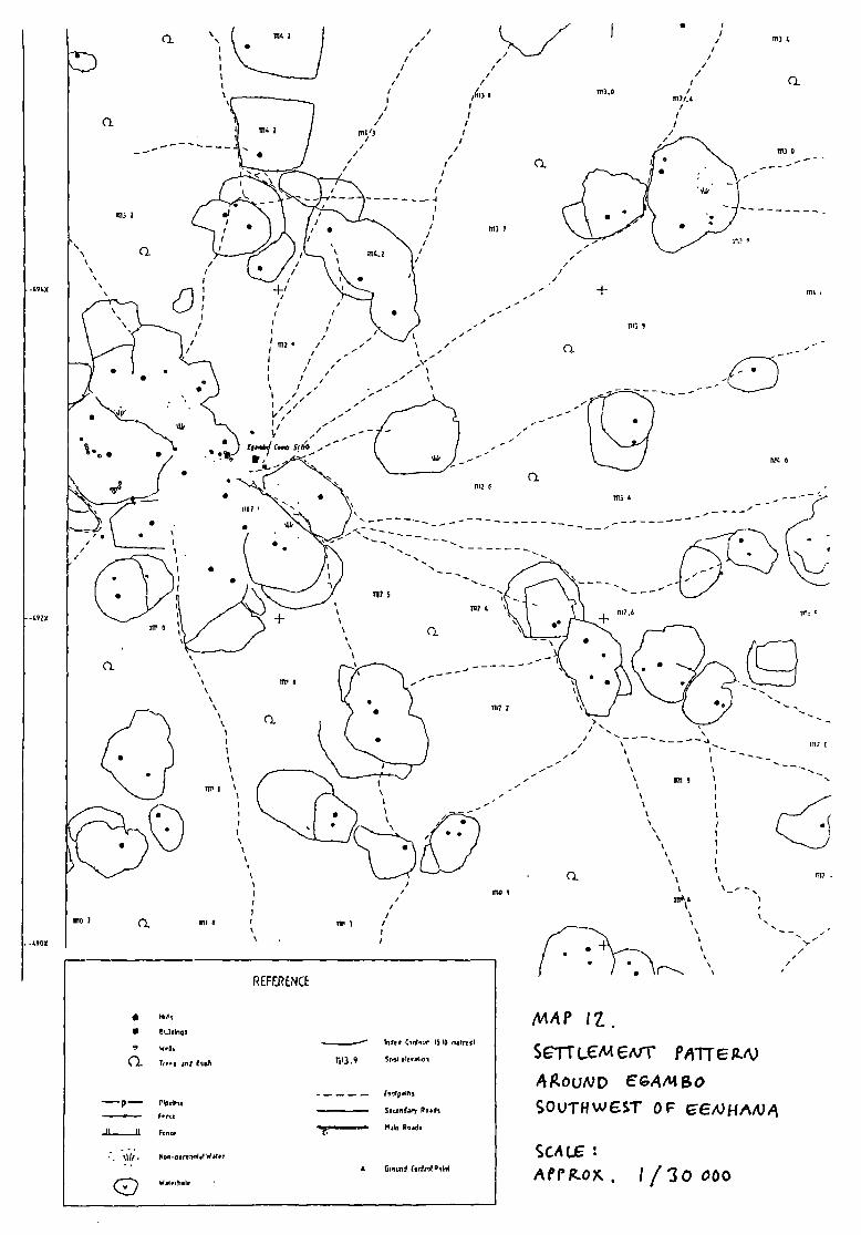
tt4’iP IZ.
S~TtLCMC~T P~’~TrEtz-’v4~.OUND E’GA,MBO
SOuTHwEST OF ~IVHAIij,~
SCALEAprg~o~,1/3oooo

WATER Suppt v AND SANITATION PROJECT IN OHANGVF~NAREGION, NAMIBIA DRAFT REPORTNo IENVIRONMENTAL IMPACTASSESSMENT STUDY OCTOBER 1994
Land and Resource Tenure
The land tenure system in Ohangwena region and northern Owambo in general is basedon a traditional communal system of land distribution and management. Modem privatelandownership and land markets exist only to a small extent in urban areas. However, agradual process of land pnvatization has already started in densely inhabited areas. Ruralland in Ohangwena region can generally be divided into following 3 categories:
1) Semi-private farmland (epya land), which is allocated to a farmer and his family forhis lifetime by the local chief or headman.
2) Communal land within the settled zone (eputa land). This land is mainly open grazingland and seasonally flooded oshana land between the individual farms.
3) Communal land outside the settled zone. This land includes distant grazing lands(land around cattle posts) as well as woodlands in eastern Ohangwena.
Land distribution and land-use control has traditionally been the responsibility of traditionalchiefs and headmen. The farmers have received land allocations for their lifetime by payinga land fee in cash or kind to the headman, who is supposed to administer the funds for thebenefit of the community. In some areas the land fee has however become private propertyof the headman
When the farmer dies, the land has to be reallocated to his widow or son, and a new feehas to be paid. A common land fee is nowadays 400-600 Namibian dollars, depending onthe size of the land. With increasing population pressure and demand for farmland, theland payments tend to increase rapidly.
Communal lands within the settled zone are unfenced and used on a free-access basisby community members for grazing and collection of fuelwood, building and fencing polesand wild fruits etc. Wells and waterholes within communal lands may be communal orprivate. Fishing in the oshanas during floods is free for all’ community members.
With growing population density the amount of communal land compared to semiprivatefarmland is rapidly decreasing, and in some areas the eputa is reduced to a series ofaccess corridors between epya farmlands. In such cases the value of the eputa as placefor free-access resources is negligible. The decrease of the amount of communal grazingland results in increasing pressure on limited grass resources unless cattle herds arereduced or livestock management practices adapted to growing scarcity of grazing land.
Communal lands outside the settled zone include forests and woodlands in the east aswell as distant grazing lands that are used as cattle posts, where cattle are moved whengrass resources in the farmlands and surrounding communal lands have been depleted. Atendency towards sedentarization of these grazing lands has been observed in manyplaces in Owambo. This means, that cattle and other livestock are maintained permanentlyat the cattle posts by employed herders while the owners live elsewhere.
FINNCONSULTOY 36


WATER SUPPLY AND SANITATION PROJECT 1w 01-lANG WENA REGION, NAMIBIA DRAFT REPORT No. 1ENVIRONMENTAL IMPACTASSESSMENT STUDY OcTOBER 1994
Another recent phenomenon is the fencing and privatization of communal grazing lands bywealthy cattle owners both within and outside the settled zone. Private access to theselands is usually acquired by paying rental fees to the local headmen. This practice is clearlyin contradiction both with traditional laws and with the land tenure policy of the government.Some of these illegally fenced grazing lands have subsequently been provided with wellsand/or boreholes for livestock watering.
The legal and administrative aspects of land use and tenure are presently rather unclear inOwambo, since the powers and responsibilities of traditional leaders versus governmentinstitutions have not yet been clearly defined. New legislation and policies regarding localgovernment, land-use control and land tenure is urgently needed to rectify the presentconfusing and unclear conditions. The ongoing legislative process concerning land tenureis at present dealing only with commercial farming areas to the south of Owambo. No newLand Bill for communal farming areas can be expected to be tabled in the near future
Farming Systems
The traditional farming and land-use system in Ohangwena region can be classified as anagro-silvo-pastoral system which combines crop cultivation, management of treesproviding edible fruits, fodder etc. and livestock rearing. All three components of thesystem are essential to maintain the productivity of the system
Climatical and soil conditions in northern Owambo can be considered to be rather marginalfor dryland crop cultivation. Small changes in the amount and timing of rainfall may easilyresult in crop failures over large areas. In these cases livestock products and fruits, nutsetc can to some degree compensate for the losses in crop production.
The crop cultivation component of the system consists primarily of omahangu (pearlmillet), which is the traditional staple food crop in Owambo. It is more drought tolerant thansorghum and maize and thus better suited for the semi-arid conditions of Owambo. Thecommon cropping pattern is mixed cropping with different crops growing on the same field.Additional crops besides omahangu can be sorghum, maize, watermelon, pumpkin,groundnuts, beans and cowpea. Maize and sorghum are usually grown only close tooshanas where soil moisture is higher. Due to rather low rainfall the yields of omahanguare fairly meager, on average only 400-500 kg per hectare annually. During dry yearsyields may drop down to less than 200 kg/ha.
In addition to field crops farmers also keep small vegetable gardens within the homestead(egumbo). These gardens usually include some fruit trees and provide tomatoes, calabash,cassava, sweet potatoes, spinach, chilli, tobacco etc. Handwatering of vegetable gardensin the dry season is common when water supply is sufficient, but large-scale irrigation isvery rare in Ohangwena region.
F!NNCONSULr Ov 37

WATER SUPPLY AND SANITATION PROJECT IN OHANGVVENA REGION, NAMIBIA DR.~rREPORT No. IENVIRONMENTAL IMPACTASSESSMENT STUDY OCTOBER 1994
Women are responsible for most of the crop cultivation activities. They do most of theplanting, weeding, harvesting and processing of field crops. Men are mainly responsible forthe ploughing of fields, management of livestock and construction of fences, buildings andgrain storage. Many farms are completely run by women when the husbands are stayingoutside Owambo looking for cash income.
Artificial fertilizer is very little used in Ohangwena region. The traditional method to maintainsoil fertility is the use of livestock manure, which is collected from the cattle-pens within theegumbo and epya. Livestock is also allowed to graze on omahangu stalks on the farmlandafter the harvest. The importance of livestock as a producer of organic fertilizer is widelyracognized.
Another method to maintain soil fertility is to shift the location of the egumbo within the epyawith regular intervals of 4-8 years. Since organic material, such as crop residues andmanure from poultry and small livestock is accumulating within the egumbo, this materialwill become part of the farmland when the egumbo is shifted. This system will not workanymore if construction of houses from permanent materials such as cement blocks andburnt bncks becomes more common.
The tree component of the system is important for maintaining some vegetation coverduring the long dry season and for the reduction of soil erosion and improvement ofrainwater infiltration into the soil. There is however and obvious need to diversify andimprove the practices of tree growing and management of trees on the farmlands andgrazing areas. Important trees are usually preserved on the farmland and harvested, butactive planting and propagation of trees is less common. Traditionally important treespecies are marula, makalani (fan palm), manketti, fig, baobab, birdplum and mopane (seesection 4.6).
The livestock component of the farming system provides many important products andservices, such as:
- meat, milk, hides and eggs- a means of wealth accumulation (investment fund)- insurance in case of crop failure- draught power and means of transport- manure for maintenance of soil fertility
Most of the cattle is of local sanga breed, which is well adapted to the semi-arid and harshconditions of Owambo. Goats and sheep are kept for meat and hides, and mules, donkeysand horses for animal traction and transport. Poultry is commonly kept within the egumbo,and sometimes also pigs.
FINNCONSULT OV 38

WATER SUPPLYANOSAWIrATION PROJECT IN OHANGWENA REGION, NAMIBIA DRAFT REPORTNo. IENVIRONMENTAL IMPACT ASSESSMENT STUDY OCTOBER 1994
Cattle rearing in Owambo is usually not based on commercial rationales, it can better beconsidered as a traditional way of life. Cattle ownership has a high social status, and alarge herd gives its owner economic security during difficult times. A sustainable take-offrate would be around 10 % annually, but in most years the actual take-off is much less. Asignificant constraint for commercial livestock production is lack of marketing outlets andfacilities.
Small livestock, calves and milking cows are usually kept continuously on and nearby thefarm, and sheltered in cattle pens or kraals within the epya during nights. Cattle are usuallyherded by young boys, but goats and donkeys are allowed to roam freely around.
Traditionally cattle movements and management follows seasonal changes in rainfall andvegetation. With the onset of main rains in January and February large and small stock isgrazed on new grass near the homestead. As grass becomes finished within the eputa,stock are moved into the epya where they feed on omahangu stalks and crop residuesafter the harvest, and fertilize the fields with manure. When fodder and grass is becomingeven scarcer during the dry season, part of the herd is taken to distant cattle posts inwestern and southwestern grasslands or eastern woodlands. Cattle herds are to someextent taken to the eastern woodlands also in the rainy season, when water is available inthe pans. This seasonal migration of livestock (transhumance), called ohambo, becomesmore and more important when competition for limited grazing land and fodder resources inthe densely settled areas increases with growing livestock numbers
The pattern of transhumance in Owambo has undergone considerable changes since the1970’s due to following reasons:
1) Fences erected along the Angolan border and around Etosha National Park havereduced availability of distant grazing areas.
2) Installation of boreholes and piped water supply in grazing areas has reduced cattlemovements during the dry season.
3) Availability of young boys for cattle herding has decreased with growing interest ineducation. The boys who attend school, can not spend long periods herding cattle.
Exact numbers of livestock are difficult to obtain due to the transhumance system, andsince people are reluctant to tell the size of their herds. Livestock numbers also fluctuatewith changing climatical conditions. Herds are decimated during droughts, and start to growagain during rainy years. A strong trend of increasing livestock numbers in Owambo canhowever be seen from livestock censuses and herd estimations during 40-50 years time.
FINNCONSULT OY 39


WA TER SUPPL YAND SAN! TA TION PROJECT IN OHANGVVENA REGIoN, NAMIBIA DRAFT RENVIRONMENTAL IMPACTASSESSMENT STUDY Oc
TABLE 6 Comparison of Livestock Numbers in Owambo in 1945, 1973 and 1992
Livestock 1945 1973 1992
Cattle 250 000 450 000 485 000Goats 120000 325000 500000Donkeys 6000 40000 120000Pigs .. 20 000 30 000Sheep .. 6 500 8 000
Sources: Analysis of Farming Systems, 1993 (Franco-Namibian Rural DevelopmentProject), Marsh & Seely, 1992Owambo Region Water Master Plan, 1990
Even though cattle herds have increased about 50 % over the 47-year period, the numberof cattle per family has decreased, since human population has increased almost fourfoldduring the same period.
Important to note is the tremendous increase of the number of donkeys, from 6 000 to120 000. It has been estimated, that only about one third of all donkeys are economicallyutilized. The rest are roaming freely around and exerting a heavy pressure on limited grassresources.
Average herd size per family in Ohangwena region is nowadays estimated to be about 12-15 heads of cattle and about the same amount of goats. Many families, however, own onlya few heads of cattle, while wealthier families may own several hundred heads, located indifferent cattle posts.
The main limiting factors for herd sizes are availability of water supply during the dryseason and availability of grazing land, palatable grass and other fodder resources, e.g.crop residues and mopane leaves etc. Improvements of water supply has in many areasresulted in increase of livestock numbers well above the long-term carrying capacity of theland, which in different parts of Ohangwena region has been estimated to be between 10and 15 hectares/livestock unit (LSU). One LSU represents one head of cattle or 4 heads ofsmall stock.
If present overstocking is allowed to continue, the long-term result will be completedegradation and finally destruction of grazing lands and grass resources. Possibilities toimprove the situation are e.g.. the following:
1) To increase offiake and to reduce stock numbers in accordance with the carrying
capacity of each area, and to introduce effective control of herd sizes.
2) To improve the system of transhumance and pasture rotation.
FINNCONSULTOv 40


WATER SUPPLY AND SANITATION PROJECT IN OHANGWENA REGION, NAMIBIA DRAFT REPORTNo IENVIRONMENTAL IMPACTASSESSMENTSTUDY OCTOBER 1994
3) To improve pasture management and to introduce cultivation of fodder trees andimproved varieties of grass and fodder as well as hay collection and storage.
Figure Farming calendar
AC TIVIT1ES Oct Nov. f Dec. Jan Feb. Mar. Apr. May Jun. Jul. J Aug Sep.Rain -‘
Vegetableproduction
Spreading of manurePreparation of soii l~.
SowingWeeding ~______________________________________Harvestinci -
Livestock
Gathering of fruit
TranshumanceResidual grazing
.
..
~Other
activitiesFishing I’ - -
Baskel-makinci /
~—_~[~j ~:~iIncrease in workload
4.9 An Overview of Environmental Degradation
Issues related to environmental degradation have been presented in different connectionsin previous sections. This section presents a summarized overview of these questions.
The different population groups of Ohangwena region have during a long historical perioddeveloped agro-silvo-pastoralist farming systems, that have been reasonably well adaptedto the semi-arid climatical conditions of the region. As long as the population density waslow and communities were surrounded by large forest and woodland areas, ways of livingand economic activities did not significantly conflict with sustainable use of naturalresources.
Alarmingly rapid growth of human and livestock populations since the 1 960s has howeverradically changed the picture. Today it is widely recognized, that ecological sustainabilityhas become seriously endangered in many parts of Ohangwena region, particularly incentral and western areas. It is now evident, that the natural resource base for human lifein Ohangwena as well as many other parts of former Owambo region will be seriouslydepleted already within the lifetime of one generation unless population pressure on theland can be reduced, more sustainable ways of crop production and livestock husbandryare developed, and the economic activities in urban and semi-urban areas are diversifiedand able to provide income opportunities for rural people suffenng of land scarcity
FINNCONSULT OY 41


WATER SUPPLY AND SAN! TA TIONPROJECT IN OHANGWENA REGIotI. NAMIBIAENVIRONMENTAL IMPACT ASSESSMENT STUDY
Before analyzing the problems of man-made environmental degradation, it .~ - -
sum up those main constraints and limiting factors of the natural environment inOhangwena region, which define the ultimate limits for human life in the region. Theseare:
* Lack of perennial surface water resources within the area.
* Relatively low and often erratic rainfall (on average 400-550 mm per annum, increasingfrom west to east)
* A very long (5-6 months) dry season
* High potential evaporation rate
* Most arable areas covered with sandy soils with low fertility, low water-retaining capacity,
low content of organic matter and deficiency in some important nutrients.
* High salinity of soils in many seasonally flooded oshanas and pans.
Limited resources of potable groundwater.
* High salinity of deep groundwater in the Cuvelai basin area.
Although Ohangwena region is a semi-arid area with agriculturally rather poor soils, thepopulation density in the western and central parts of the region is rather high, up to 100people/square km. This high density within the Cuvelai basin area is made possible by theoshana drainage system with periodic surface water flows, which recharge groundwater,renew grazing and bring fish into the area. Thus the sustainability of the oshana drainagesystem as a whole and the safeguarding of undisturbed flow within the system is a questionof life and death for the inhabitants of the region.
The most essential natural resources that people depend on are: fresh water (rainwater,ephemeral surface water and groundwater), grazing, suitable soils for crop cultivation andtrees, which provide edible fruits, palatable leaves, firewood and poles for fencing andhouse construction etc. At present there are numerous indications that these limited naturalresources are overexploited, and that future prospects for the inhabitants are bleak unlessstrong corrective measures are taken urgently on a broad front
The processes of man-made environmental degradation are cumulative results ofinterlinked activities causing over-exploitation of the natural resource base. Theseprocesses can be summarized under following 7 main headings:
1) Deforestation of existing forests and woodlands and decrease of tree biomass anddensity in the Cuvelai basin area (densely populated areas)
FINNCONSULT Ov 42

WATER SUPPL V AND SANITATION PROJECT IN OHANGII~ENAREGION, NAMIBIA DRAFT REPORTNo. IENVIRONMENTAL IMPACTASSESSMENT STUDY OCTOBER 1994
2) Accelerating deforestation due to agricultural expansion in the eastern less populated
areas
3) Extensive degradation and depletion of grazing land and grass resources
4) Soil erosion and declining soil fertility in cultivated croplands
5) Changes and disturbances to surface flows in oshanas due to infrastructuredevelopments
6) Unsustainable utilization of groundwater resources in some areas
7) Contamination of surface waters from human and animal waste
These environmental problems and degradation processes are presented and discussed
below:
Deforestation
The deforestation process has a rather long history in Owambo. Some early documentsfrom the late 19th century (Hugo Hahn in 1866 and Hans Schintz in 1886) describe vastforests and woodlands stretching out between the different kingdoms and communities,and give also indications of rapid deforestation in some localities. Government reports fromthe 1930’s and 1960’s paid attention to deforestation, and considered it to be one of thegreatest economic and environmental problems in the region. Many Owambo people whoreturned in 1990 from long periods of exile, have expressed their astonishment anddisappointment of the disappearance of vast forests and woodlands they had known beforeleaving for exile.
The main causes behind this massive and accelerating deforestation process are twofold:
a) Conversion of forests and woodlands into farmland, grazing land and settled area
b) Overexploitation of the resources combined with lack of management and
replacement planting
Population growth and resulting demand for more cropland and grazing land has alreadyfor many decades forced people to settle in the woodlands wherever they have managedsomehow to secure a minimum water supply. Thus the forest boundary in the eastern partof Cuvelai basin has continuously moved eastward. This has been clearly documentedfrom satellite images from the 1970’s and 1980’s. These images show also continuouslygrowing openings within the eastern forests and woodlands.
Today the demand for new agricultural land is growing faster than average populationincrease (about 3,1 % annually), due to declining fertility and productivity of older croplandsand due to agricultural mechanization on more affluent farms. This growing demand forfarmland can be limited only if job opportunities are created in urban areas for those ruralpeople willing to move into towns and give up agnculture in favour of urban employment.
FINNCONSULT OY 43


WA TER SuPPLY AND SANITA nON PROJECT IN OHANG~NAREGION, NAMIBIA DRAFr REPORT No. IENVIRONMENTAL IMPACTASSESSMENT STUDY OCTOBER 1994
Overexploitation of trees is caused both by wasteful use of fencing poles and firewood andthe present unclear and uncontrolled resource tenure systems.
Woodlands have traditionally been communal land and a free access resource for themembers of the community. This opportunity has been recently much utilised bycommercial loggers, who cut firewood and poles in communal woodlands free of chargeand take them to the towns for sale.
Especially endangered by increasing illegal logging and woodcutting are valuableconstruction and polewood trees, such as mopane, kiaat, Zambezi teak and Terminaliasencea. Mopane and Terminalia are also much used as firewood.
Officially commercial logging and woodcutting requires a permit issued by the Directorateof Forestry. Legal restrictions on cutting of trees do however not seem to have muchpractical effect as long as no effective control system exist. The present period is aninterim period when traditional local authorities are losing power and traditional controlmechanisms are breaking down, but no new mechanisms have been established to replacethem. The Directorate of Forestry is in principle responsible to control logging and treecutting, but the task is impossible to carry out effectively with present manpower resources.Close cooperation between the Directorate of Forestry and local communities is essential ifexcessive illegal logging and woodcutting is to be prevented.
FINNCONSUL rO~ 44


SCALE
(A)1~+~OUQAMgO
FP~OM & SI1Sk~-o~v~A)
MOSSAMEDES
‘I
r
ONGANDJERA
TSCHAMBOMBE-VL(i ~.
0
PERENNIAL RIVERSPERiODICAL RIVERSMAIN TRAVELLING ROUTESIMPORTANT WATER PLACESPROTESTANT MISSION STATION
105 0
OMAHEKE
50
/M1’ I~. L.oc..Ar?o’V OF
(~‘5O ~?S
TO TSUMEB
COMM UN/I)
lqqz


WATER SUPPLY AND SANITATION PROJECT IN OHANGWENA REGION, NAMIBIA DRAFT REPORTNo IENVIRONMENTAL IMPACTASSESSMENT STUDY OCTOBER 1994
In order to decrease the pressure on remaining natural forests it is also of utmostimportance to promote different forms of tree cultivation within the settled areas. Thetraditional tree management component within the farming system should be strengthenedby introducing modem agroforestry methods as well as farm and community forestryactivities to satisfy the needs for firewood, fencing and construction poles, edible fruits andlivestock fodder, material for household items, medicinal products etc. Particularlyimportant is introduction of leguminous nitrogen-fixing tree species, such as Acacia albida
,
Leucaena leucocephala, Ziziphus mauritania and Casuanna species, which can contributeto restoration of soil fertility on cropland
Research on agroforestry methods has already for some years been undertaken atOgongo Agricultural college with promising results. Small tree nurseries have beenestablished in some locations by government institutions and different NGO’s, e.g. theRural Development Centre, church organizations, Green Namibia project and DAPP.These organisations are also providing training and advice in agroforestry and gardeningpractices as well as trying to promote the use of fuelwood-saving stoves and cookers.However, in order to yield substantial results, these activities and services have to bemultiplied and introduced all over Owambo.
Water supply plays an important role in the establishment of tree nurseries and promotionof tree cultivation. These activities are possible only in places where sufficient water supplyis available. However, an important use of household waste water from washing and foodpreparation should be watering of tree seedlings and young trees within or nearby theegumbo.
The most important issues in the prevention of waste and overexploitation of trees is tointroduce wood saving methods of fencing and house construction. Especially use of livefences (f.ex. Euphorbia species) has in many cases proved to be a viable solution. Trialswith fuel-efficient stoves have been carried out in many parts of Namibia, and manydifferent stove types have been tested. However, in Ohangwena region these stoves havenot yet been widely accepted by housewives.
Antti Erkkila and Ham Siiskonen (1992) have studied the extent of deforestation inOhangwena and Oshikoto regions in the 1970s and 1980s by comparing recent Landsatsatellite images with topographical maps in scale 1:250 000 published in 1975. Their studyshows that the forest boundary has been steadily moving eastwards, and that openclearances within the woodland areas have grown considerably (See Map 14).
Fabnce Renaud and Hannu Pelkonen (1994) have recently studied deforestation in a 10-15 km broad corridor between Omafo and Eenhana south of the Angolan border along theOmafo-Eenhana water pipeline. They found that deforestation in the study area was ratherlimited in the 1970’s and 1980’s, since people were reluctant to settle there during thewartime due to safety reasons. After independence forest clearing in the area hasaccelerated, and it can be assumed, that settlement of people will rapidly increase whenthe new water pipeline (which at present is under construction) becomes operational.
Monitoring of changes in population density and settlement patterns in the study areashould be camed out after the new pipeline has been taken into use.
FINNCONSULT Ov 46

‘7

16° I 15’ 16°130’
/~4~/L/.
Deforestation ofdry deciduousforest in
Owambo
Source:Former forest border(solid line): South WestAfrica 1:250 000 topo-graphical sheet 1716Eenhana,secondedition1975.
Forests (black areas):LandsatMSS image of/939. Interpreted at rueUniversityofJoensizu
F~-0M iS(LV.~L~.~L.~ SI1SK~O4I1EA)( /~Z

WA TER SCJPPLv AND SANITATION PROJECT IN OHANGI~IENAREGION, NAMIBIA D~wTREPORT No. 1ENVIRONMENTAL IMPACTASSESSMENTSTUDV OCTOBER 1994
Degradation of arazlng land
The system of livestock husbandry and pasture management as well as causes foroverstocking and overgrazing is described in section 4.8. The problem of overgrazing isclearly visible all over the densely populated western parts of Ohangwena region,especially in the vicinity of livestock watering points (ponds, dams, wells, boreholes andpiped supplies). When overgrazing and extensive trampling goes on continuously for longperiods without sufficient recovery periods for grass growth, the result will be that lesspalatable annual grasses replace good quality perennial grasses and toxic and impalatabletypes of vegetation start to invade the land. The most destructive animals are the goatsand the donkeys. A recommended grazing land recovery period should according to theSARDEP project be 130-140 days annually.
Degradation of grazing land is further escalated if grasses are eaten before seeds have setand been dispersed. This leads in the long run to depletion of the seed banks in the soiland further increase of invasive plants instead of grasses
Irreversible degradation of the grazing lands will inevitably follow unless overstocking andovergrazing can be prevented. The main means to achieve this are the following:
1) Effective community control of herd sizes in each area2) Well managed transhumance and pasture rotation arrangements3) Promotion of fodder cultivation and planting of fodder trees4) Clearly defined user nghts and responsibilities for community members concerning
use of communal grazing lands5) Well planned siting of livestock watering points6) Community control of water use for livestock watering
Decline of soil fertility
Numerous studies have indicated a continuous decline of soil fertility on croplands indensely populated areas, with resulting decline of crop yields. The main reason to thisproblem is the shortening of fallow rotation periods due to increasing land scarcity andincrease of soil erosion due to lack of trees and other protective vegetation cover.Traditional methods of fertilising croplands with livestock manure and by periodical shifts ofthe egumbo compound within the epya land are not anymore sufficient methods to restoresoil fertility in the long run.
New methods of restoring soil fertility and protecting the land from soil erosion could bepromotion of intercropping with leguminous crops, e.g. beans and groundnuts, andpromotion of agroforestry methods using nitrogen-fixing tree species, e.g. Acacia albida
,
Leucaena leucoceDhala, Ziziphus mauritania and Casuarina species.
A previously unutilized source of fertiliser is fertile sediment, which is due to soil erosionfilling up dams and ponds used for livestock watering. Removal of this silt would increasethe water storage capacity of the reservoirs and provide natural fertiliser for cropland andvegetable gardens. High salinity of sediments may however in some cases be an obstacle.
FINNCONSIJLT Ov 48

V~1’
V
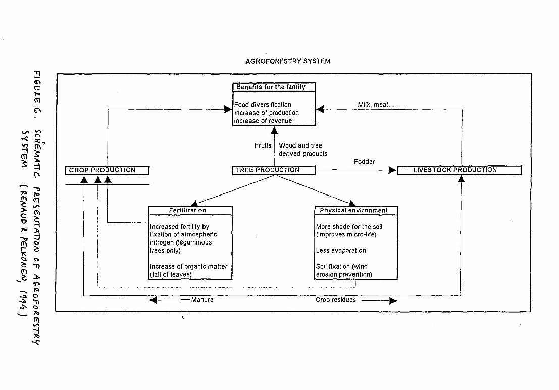
(Ti
(TiC”
I
~1
C
AGROFORES TRY SYSTEM
Food diversificationIncrease of productionIncrease of revenue
Milk, meat...
Benefits for the family
4h~
4
ICR0PPROPUCTION I 1~~DUC1ION
A
Fruits
Fertiiization
Increased fertility byfixation of atmosphericnitrogen (leguminous
trees only)
Increase of organic matter(fall of leaves)
Wood and treederived products
_________ Fodder
1 LIVESTOCK PRODUCTION
Physical environment
Crop residues
More shade for the soil(improves micro-life)
Less evaporation
Soil fixation (winderosion prevention)
..14 Manure

WATER SUPPLYAND SANITATION PROJECT IN OHANGWENA REGION, NAMIBIA D~wr REPORTNo. IENVIRONMENTAL IMPACTASSESSMENT STUDY OCTOBER 1994
Changes of surface flow in oshanas
Recent infrastructure developments in the Cuvelai basin area have to some extentchanged the conditions for surface flow in oshanas with detrimental effects on grazinglands and groundwater tables in the southern and southwestern parts of the basin area.Roads and water canals built in the area between Oshakati and Ruacana since the early1960’s have to a considerable degree prevented southward surface flow in the oshanasacross these infrastructure developments.
This is the case especially concerning older canals with raised embankments runningacross the oshana drainage system. Although the new asphalted main road has beenprovided with numerous bridges and culverts, it has still prevented oshana flows in someareas. The main indication for such effects is that oshanas to the south of theseinfrastructure lines dry up much earlier than the oshanas on the northern side. Thus thediversion of oshana flow has had adverse effects on the southern side, while people on thenorthern side may have had some benefit from accumulation of surface water.
The above described infrastructure developments are located outside the WSSPORproject area and do not affect oshana flows within the area. However, new developments inthe northern part of the WSSPOR area may affect oshana flows unless flow regimes arecarefully considered during planning and design of new developments. This appliesparticularly to road construction in east-west direction.
Unsustainable use of groundwater
Lowering of groundwater tables due to high pumping rates has become a common problemin many parts of Namibia. Since recharge of groundwater from rainfall and ephemeralfloods is very limited due to high evaporation rates, pumping of groundwater will easily leadto lowering of the groundwater table, with resulting adverse effects on vegetation and watersupply in the long run.
With the exception of discontinuous perched aquifers, which often dry up during the dryseason, problems with sinking groundwater tables due to excessive pumping have not yetbeen recorded in Ohangwena region. However, this risk should be taken intoconsideration, especially in connection with the planning of boreholes for deep groundwaterextraction in the eastern parts of the region. Monitoring of groundwater levels at boreholesis necessary in order to prevent over-pumping.
Surface water pollution
Floodwater in the oshanas has mostly a rather good hygienic quality, but standing watercollected in dams and ponds gets easily polluted from human and animal waste. The mainreasons are free access of livestock into the reservoirs and inadequate human sanitation.Domestic animals contaminate the water directly by wading and with droppings and urine,and contamination from human waste is transported during heavy rains with surface flowfrom nearby places used as open-air toilets.
FINNCONSULT OY 50


WATERSUPPLY AND SANITATION PROJECT IN OI-IANGWENAREGION, NAMIBIA DFWTREPORT No IENVIRONMENTAL IMPACT ASSESSMENT STUDY OCTOBER 1994
These problems can be solved by preventing direct livestock access to the reservoirs andby improving sanitation in surrounding homesteads, schools, clinics, cuca-shops etc. Allopen ponds and reservoirs should be provided with fences and separate livestock wateringtroughs. This will also improve the possibilities for the communities to control stockwateringat reservoirs.
4.10 Household Structure, Economy and Incomes
Traditionally the family structure among Owambo people is based on matrilineal principles,and descent is traced through the maternal side of the family.
Rural households are usually formed by extended families, which provides social andeconomic support to family members, and serves as a basis for child-rearing. Children areoften raised by family members other than their own parents while these are away.
The system of migrant labour was established during the colonial period, and it is still astrong component of life in Owambo. A considerable part of the male population in workingage spend part of their life working elsewhere in Namibia on commercial farms, in mines,industries, construction, transport etc. Accordingly the proportion of female-headedhouseholds is rather high. The average size of an extended family is 10-11 persons, butaverage sizes of households are around 7-8 members, since about 20 % of the membersare living elsewhere.
Financial transfers from family members working elsewhere in Namibia are importantcontributions to household incomes. They may constitute as much as 15-20 % of totalfamily incomes. Also pensions are an important source of cash income for many families.Reliable figures for the incomes of rural households are difficult to obtain. Surveysconducted in different parts of Owambo dunng 1990-93 give average household cashincomes between 900 and 3 000 Namibian Dollars (Rand) per annum. The main sources ofhousehold incomes in the western and central parts of the WSSFOR project have beenestimated to be the following:
- wage employment- informal sector work- remittances from relatives working elsewhere- pensions- home production sales (local beer, meat, vegetables, baskets etc)
Most of the farm produce is consumed within the household, and cattle is rarely sold forcash. When livestock is transferred it is often done by barter. For omahangu, the staplefood crop, there is no formal market, since most of the produce is consumed at home. Withaverage yields of 300-400 kglhectare, total omahangu production per family may be in therange of 700-1 000 kg annually.
Calculated return from farm labour is only about 5 ND per day while prospective salariesfrom off-farm labour may be between 10 and 20 ND per working day.
FINNCONSULT Ov 51


WATERSUPPL YAND SANITATION P~o./EcTIN OHANGWENA REGION, NAMIBIAENVIRONMENTAL IMPACT ASSESSMENT STUDY
DRAFTREPORTNO IOCTOBER1994
4.11 SocIal Conditions and Services
Development of social services (education, health services, water supply etc) was muchneglected in Owambo during the colonial period, and the level of services still remains low.
At present there are 135 primary and secondary schools within the WSSPOR project area.The number of registered students is about 58 000, which is about half of the totalpopulation in the area. Although most of the school-age children attend school today, veryfew people have received education beyond standard C, which means 8 years ofschooling.
Health problems in the region are often connected with poor sanitation, inadequate watersupply and contaminated drinking water as well as malnutrition. The most commondebilitating and frequently fatal diseases are malaria, measles, diarrhoea, dysentery,hepatitis, acute respiratory infections, plague, tuberculosis and sexually transmitteddiseases, including AIDS. Table 7 presents some statistics of clinical cases in the whole ofOwambo in 1989-92.
TABLE 7 Numbers of Clinical Cases of Common And/Or Serious Diseases inOwambo During 1989-92
Year/ 1989-90 1990-91 1991-92Diseases
Malaria 77 798 222 393 167 009Measles 2 788 926 719Plague 146 163 1 364Malnutrition 417 242 . 14 150Tuberculosis - - 1 500Hepatitis 149 249 264HIV - 66 232Other sexuallytransm. diseases 9 727 15 520 7169
Malnutrition is well above the national average, with over 30 % of pre-school childrensuffering from moderate to severe malnutrition. Occurrence of water-borne and water-related diseases follow a district seasonal cycle. The incidence of diarrhoea increases withincreasing salinity and contamination of water resources towards the end of the dryseason, while the number of malana cases grows in the latter part of the rainy season.
FINNCONSULT Ov 52


WATER Suppi. Y AND SANITATION PROJECT IN OI-4ANGWSNA REGION. NAMIBIA Da~T REPORTNo. IENVIRONMENTAL IMPACTASSESSMENT STUDY OCTOBER 1994
Malaria is at present the most serious health problem in the Cuvelai basin area. Thepresence of open standing water for long periods of time in oshanas and pans, omifima,wells, canals and dams, coupled with a long warm season, creates an ideal environmentfor malaria-carrying mosquitoes (Anopheles species). Furthermore, people exacerbate theproblem by the indiscnminate disposal of cans, bottles, car tires and plastic containerswhich become breeding sites for mosquitoes. Control measures to date have largelyfocused on treatment in hospitals and clinics and on reduction of adult mosquitoes throughan extensive homestead DDT spraying campaign that is carried out annually. Recently,authorities have started a comprehensive national malaria control programme and arepromoting the use of mosquito nets as one of the methods to further reduce the incidenceof malaria.
Careless disposal of bottles and cans along the roadsides and around settlements isalso a serious health hazard for people walking barefoot, especially children. Broken glassbottles can be observed in enormous quantities all over Owambo on roadsides and tracks,partly hidden by sand.
The common bad habit of throwing bottles and cans all around the landscape is of coursealso economically wasteful. This problem should be urgently tackled by organising effectiverecycling systems for glass and metal cans.
Poor sanitation is a serious environmental health problem in Ohangwena region. Thetraditional methods of using surrounding croplands and bush as open-air toilets results incontamination of surface waters during the rainy season and an effective distribution ofmany water and excreta-related diseases, such as amoebiasis, diarrhoea, dysentery,hepatitis, salmonellosis, ascariasis, hookworm etc. Schistosomiasis which is all over Africaa common water-related disease resulting from poor sanitation, is not common in Owambosince most of the surface waters are ephemeral, and the water snail which is a host to theschistosome parasite, does not survive in the oshanas. However, when dams and pondswith permanent water storage are constructed, there is a risk of schistosome contaminationunless sanitary conditions are improved.
Promotion of the construction of proper pit latrines and VIP’s (Ventilated improved pitlatrines) in schools, clinics, cuca-shops and homesteads has been since some years backundertaken by numerous projects and organizations including the WSSPOR project,UNICEF, Ministry of Health, church organisations, NGO’s etc., but still it can be observed,that properly built and well maintained latrines are very rare in the rural areas ofOhangwena region.
Health services are presently being improved in Ohangwena region with assistance fromFinland, France, UNICEF and various NGO’s and church organisations. New hospitals areunder construction in Engela and Eenhana and a health center in Odibo is being upgraded.Altogether there are at present 18 clinics in operation within the project area.
FINNCONSULT Ov 53


WATER Sup,’t. V AND SANITA TIONPROJECT IN OHANGWENA REGION, NAMIBIA Da.~Fr REPOR rNo. IENVIRONMENTAL IMPACTASSESSMENT STUDY OCTOBER 1994
Water supply in Ohangwena region is based on following water resources, as presentedin sections 4.4. and 4.5.:
1) Imported water from Kunene river in Angola, carried by an extensive systemof canals and pipelines into western and central parts of Owambo
2) Uti’ization of ephemeral surface water flowing into oshanas and pans duringfloods in the rainy season
3) Collection of rainwater from roofs and ground catchment areas into reservoirsand ponds
4) Utilization of shallow groundwater from either discontinuous perched aquifers(DPA) or the main shallow aquifer (MSA) by means of hand-dug wells andwater holes (ndungus and omafima)
5) Utilization of deep groundwater by means of borehole wells
All above mentioned sources and means of water-supply are connected with differentproblems related to e.g. seasonality, water quantities, water quality and costs of the supplysystem. Thus a safe and adequate system ofwater supply in Ohangwena region has torely on all relevant sources of water.The Water Master Plan for Owambo, prepared in 1990 by DWA proposes to develop the
following means of water supply to meet future needs of the growing population:
* Extension of the existing system of canals and pipelines to feed water fromthe Caleque Dam in Angola into the interior of Owambo.
* Continued construction of storage dams which could be fed with water from
local run-off or from the proposed water supply network.
* Drilling of additional boreholes in the eastern and western farming areas.
* Construction of improved wells and cisterns to serve rural schools and clinics.
The priorities determined by the Master Water Plan were to develop local water sourcesfirst, and then to import more water from the Kunene River. This principle still applies today.
FINNCONSULT Ov 54

WATER SUPPLY AND SANITATION PROJECT IN OHANGI.WNA REGION, NAMIBIA DRAFT REPORT No. IENVIRONMENTAL IMPACT ASSESSMENTSruo~ OCTOBER1994
5 DESCRIPTION OF THE WATER SUPPLY AND SANITATION PROJECT INWESTERN OHANGWENA REGION (WSSPOR)
The WSSPOR project is a part of the bilateral development cooperation programmebetween Finland and Namibia. The project commenced in March 1992 and will continueuntil the end of 1996. Total project budget is about FIM 39 million, out of which FIM34 630 000 will be financed by the Government of Finland.
The competent authorities are the National Planning Commission of Namibia (NPC) andthe Ministry for Foreign Affairs of Finland/Finnish International Development Agency(FINNIDA). The Namibian implementing agency is the Ministry of Agriculture, Water andRural DevelopmenVDepartment of Water Affairs (DWA). During 1992 and 1993 the projectwas implemented by the Directorate of Rural Development within the same ministry.Consultant for development assistance services is Finnconsult Oy from Finland. ASupervisory Board, with members from the competent authorities, is responsible for projectsupervision at policy level, and a Steering Committee, with members from relevant involvedinstitutions takes care of coordination and supervision at implementation level.
Tile objectives of the WSSPOR project are according to the final Project Document,approved in December 1993, the following
“The long term development objective of the project is tosupport the Namibian Government’s efforts to secure a safeand adequate water supply as well as proper sanitation for therural population of the project area. By achieving thisobjective the general health situation, standard of living andeconomic opportunities will be improved
The objectives of the Community Development sub-projectare to encourage, organize and train communities to initiate,construct and manage their water supply and sanitationsystems by giving technical assistance complemented bymaterial and financial support and by supporting the drillingprogramme in the area
The objectives of the Construction Capacity sub-project are todevelop local contracting capacity for water supply andsanitation construction and to encourage local production andsupply ofconsiruction materials complemented by localtransportation capacity.
The objectives of the PIannin~and Design sub-project are toprepare development plans for water supply and sanitation forthe project area and to establish a water supply and sanitationinformation system serving the needs of the Government andcommunities.”
FINNCONSULT OV 55


WATERSUPPLYAND SANITATION PROJECTIN OHANGV~ENAREdo,.,, NAMIBIA DRAFT REPoi~rNo. IENVIRONMENTAL IMPACT ASSESSMENT STUDY OCTOBER 1994
The ultimate target group of the project is the rural population of the project area. Specificattention in project implementation is given to women, who are responsible for water,hygiene and health issues in the households.
Additional specific target groups are staff of the Department of Water Affairs, working inOhangwena Region as well as local contractors and enterprises involved in physicalimprovement of water supply and sanitation.
Institutional frameworks and project organization is presented in Figures 7 and 8.
FINNCONSULT 0 v 56


THE FRAMEWORK OF TIlE PROJECT ENVIRONMENT
Ministry of
Health and~• educationIn
• h~g1ene• contamination• water use
• control of• water quality• sanitation
Ministry ofRegional andLocalGovernmentand housing
~stryof~ construction ofwater supply andEducation and sanitationCulture facWtles
[~~nlstry ofAgricuituro
- Water andRuralDevelopment
~appropriatetechnologyoperation andmaintenanceofcommunity schemes
• costs,costrecoverytraining
\17
Ministry ofWildlife,Conservationand Tourism
• encou~ragingandestablishingoflocal materialsupply andtransportation
PrivateEnterprisesandLocalContractors
5 procurementof materials,spareparts,provisionof
~1 transport1~ Construction of watersupply andsanitationcontracting
•11pC(TI
Ifsanitation
S coordinationwith communitydevelopment
1
• water master plan• monitoring of water
resourcesboreholes
P ft 0 J E CT
COMMUNiTY DEVELOPMENT• education- training- construction• management
.5 preparation ofthe EIA
PLANN11~G• water resourcesdevelopment- environmental sustalnabiUty
DEVELOPMENTOF LOCALCONTRACTORS
DEVELOPMENTOF LOGISTICS
[~~r NGOSandDonorsactivein
lItheWaterfi Supply andSenita tina
I
S
liaison in developmentof procedures andpractisesjoint training
training the • training thecommunitiesIn contractors inplanning, P construction ofmanagement, water supply aridoperation & sanitationmaintenance,constructing and
contracting1~.I
COMMUNITIES
I BENEFICIARIES I


F:I~ug~g• PROJECTORGANOGRAM
Sub-Project: Sub-Project:Community Development Construction Capacity
________________________ Building
Government of Finland Government of Namjbja
Supervisory_Board
MAWRD/FINNIDA
Steering Committee
DRWS, DEES, HBSS, NEC, DCD, RC,Embassy of Finland, EAIHP,Chamber of Commerce, CWC
Sub-Project:Planning and Design


WATER SUPPLYANO SANITATION PRoJEcT/N OHANGWENA REGION, NAMIBIA DRAFT REPORT No IENVIRONMENTAL IMPACTASSESSMENTSTUOY OCTOIIER 1994
6 INSTITUTIONAL FRAMEWORK FOR WATER SUPPLY DEVELOPMENT
Overall responsibility for water supply issues within the state administration belongs to theMinistry of Agriculture, Water and Rural Development, and within the ministry to theDepartment of Water Affairs (DWA).
At the beginning of 1993 the responsibility for rural water supply was transferred from theDirectorate of Rural Development (Department of Agriculture) to the Directorate of RuralWater Supply (DRWS) within the Department of Water Affairs. At present the Directorate ofRural Water Supply is responsible for planning, implementation, operation andmaintenance of the rural water supply network.
The organogram of the DRWS has been approved by the Cabinet and Public ServiceCommission, but due to lack of financial resources the actual start-up of full field operationswill require a period of 3-4 years. The new establishment will actually have little influence inOhangwena Region. Maybe only 2-3 water extension officers will be appointed for theOhangwena Region in order to facilitate and control the development of community basedrural water supplies. There are no further plans for office or other facilities in the region.Therefore the implementation, operation and maintenance of community based rural watersupplies will greatly depend on the activity and participation of the communities themselvesas well as of the local NGO’s and donors.
The Ministry of Regional and Local Government and I-lousing through the Directorate ofCommunity Development in liaison with Regional Councils and Local Authority Councilsand other ministries (MHSS, MEC, MAWRD) support self-help schemes and assistcommunities in organizing themselves. The Regional Council is responsible for planning ofthe development of the region with a view to:
* natural and other resources and the economic development potential
* existing and the planned infrastructure such as water, electricity, communication
networks and transport system
* sensitivity of the natural environment
The various Development Committees at Regional, Areal (Constituency) and Sub-Areal(area of one headman) levels as well as the Central Water Committee play leading roles ininitiating and prioritizing projects.
The Ministry of Health and Social Services (MHSS) in liaison with other ministries play themajor role in environmental health planning, development, training and promotion. PHCServices and especially Health Inspectors and Environmental Health Assistants at Districtlevel and Community Health Workers and Promoters at local level participate in theimplementation of sanitation, hygiene education and control of water quality in cooperationwith the WSSPOR project. Close coordination and joint pañicipation in establishment andtraining of health and water committees is required between the project and PHC Services.
FINNCONSULT Ov 59

WATER Suppi~vAND SANITATION PROJECT IN OHANGWENA REGION, NAMI8JA Diwr REPORT No. IENVIRONMENTAL IMPAcTAsSESsMENTSTUOY Ocro8ER 1994
The WSSPOR, MRLGH, MHSS and some local NGO’s are actively involved in communitydevelopment work in the Ohangwena Region. There are plans to establish anintersectoral development committee network in the Region. The participation oftraditional leaders, church representatives, political party representatives and differentwomen groups should not be neglected when development or implementation plans arediscussed or executed in the area.
The informal Water Supply and Sanitation Technical Support Committee withmembers from Government offices and from NGO’s, already established for Central-NorthNamibia, form a discussion, coordination and information exchange forum for all water andsanitation related projects, NGO’s and government bodies in Northern Namibia. Thecommittee meets when need arises.
FFNNCONSULTOY 60

WATER SUPPLY AND SANITATION PROJECT IN OHANGWENA REGION, NAMIBJA DP~rREPORT No IENWRONMENTAL IMPACTASSESSMENT Sruov OCTOBER 1994
7 ENVIRONMENTAL ISSUES IN WATER SUPPLY AND SANITATIONDEVELOPMENT
Adequate water supply is a basic requirement for economic activities and human welfarewithin all communities. Access to potable water for people and livestock has in Ohangwenaregion as well as all of Owambo historically been the main limiting factor for growth andspatial distribution of human settlements.
Those areas, which up to present time have remained largely unsettled or only sparselysettled, are the only areas where larger natural forests and woodlands still exist. Thesewoodlands are now important sources of many kinds of natural products and raw materialsneeded by communities in Owambo. They are also valuable grazing lands utilized withinthe transhumance system as well as important reserves for biodiversity. Furthermore, theirrole in the local climatical system is considered to be significant.
Main constraints to human settlement in these eastern parts of Ohangwena region hasbeen lack of perennial surface water resources and major oshanas, and the fact thatpotable groundwater is located in deep aquifers (deeper than 70 m), which are out of reachwhen traditional hand-dug well structures are used.
When this deep groundwater is made available by means of modern borehole wells, orwhen piped water supply networks are extended further eastward, the result will be a rapidinflux of farmers from the densely populated Cuvelai basin region. This will considerablyaccelerate the deforestation process that has taken place in Owambo already for decades.
In order to prevent such an accelerated deforestation process in eastern Ohangwenaregion, a comprehensive and integrated land-use plan should urgently be prepared toguide all future water supply developments in the region.
Legal and institutional frameworks for effective land-use planning are still rather weak inNamibia, and it will certainly take time before the complicated political issues associatedwith land tenure and land use have been fully settled on a national scale. In view of this factit seems necessary to take initiative on the regional level in order to start the process ofdeveloping an institutional framework and professional capability to carry out the tasksincluded in overall land-use planning.
Since availability of water for livestock has already for along penod been a major limitingfactor for the growth of herds, it is evident, that the location and amount of water availablefor livestock is a very important issue concerning the prevention of overgrazing and landdegradation.
There are numerous examples from semi-arid environments in Africa, particularly the Sahelregion south of the Sahara desert, when extensive expansion of water supplies have in thelong run resulted in irreversible degradation of grazing lands and depletion of grassresources, and thus also a collapse of the livestock husbandry system. Such a process isillustrated in Figure 9
FINNCONSULT 0v 61


FIGURE 9.RISKS RELATED TO IMPROVED WATER SUPPLY ~NECOLOGICALLY FRAGILEAREAS WITH EXTENSIVELIVESTOCK REARING
Situation 1
o Abundant and healthy grass coverbetween water points
o Good quality perennial grasses
o No toxic plants and invading species
a location ofwell or water pointA heavily denuded, mostly bare groundB overgrazed and trampled landC healthy grass cover
Situation2
o Large portion of the area bareground and heavily overgrazed andtrampled
o Perennial grasses being replaced bylow-quality annual grasses
o Unplatable and toxic speciesinvading the land
o Accelerating soil degradation anderosion
o Groundwater table falling and loss ofwoody vegetation
0km 1km 2km 3km

7

WA TER SUPPLY AND SANITATION PROJECT IN OHANGWENA REGION, NAMIBIA DRAFT REPORT No IENVIRONMENTAL IMPACTASSESSMENTSTUOV OCTOBER 1994
In order to prevent environmental degradation of vulnerable grazing lands, it is absolutelynecessary to carefully study available grass resources and estimate the carrying capacitiesof each area before the location of water supply points is decided upon. This questionshould preferably be studied as a part of a land-use planning exercise.
The question of spacing of livestock watering points in vulnerable areas needs to bestudied further. A proposal, that was put forward during the WSSPOR Workshop onEnvironmental Assessment in May 1994, was that in vulnerable grazing lands the distancebetween livestock watering points should not be less than 15 km. Thus a planning standardfor such areas could be that water supply points for human consumption would be providedwith about 5 km distances and every third water supply point would include also livestockwatering facilities.
The risk of lowering of groundwater tables due to high pumping rates is another issuewhich has to be carefully considered when plans for borehole drilling are prepared. Reliabledata on the groundwater reserves of the deep eastern aquifers are still scarce, and furthergroundwater investigations are needed before sustainable pumping rates can beestablished for different locations. Since groundwater recharge from rainfall is very limiteddue to the high evaporation rate, the risk of over-pumping should always be taken intoaccount, and careful monitoring of groundwater levels should be carried out.
Opportunities for Environmental Enhancement
Improved water supply in Ohangwena region is connected with environmental risks asdiscussed above, but it can also provide opportunities for environmental enhancement,especially by improving possibilities for afforestation and farm forestry I communal forestryactivities as well as for horticulture and vegetable gardening and establishment ofdemonstration plots in school gardens.
An important issue in this connection is: Will planting of trees and vegetable gardening becompeting of the scarce water resources ? Which are the prionties of the farmers whenavailable water is not enough for both activities?
The issue of establishing small tree nurseries and woodlots adjacent to water points(standpipes, wells, boreholes, ponds etc.) should be introduced as part of the water supplyproject in cooperation with the Directorate of Forestry. The first opportunities to test thevalidity of this idea could be when the siting of water standpipes is discussed with the newlyestablished Water Point Committees in the area served by the new Omafo-Eenhanapipeline. Important questions to solve will then be:
* Who will take initiative and make decisions ? The roles of thecommunity/individuals and extension staff.
* Responsibilities in the management of the facility (Water Point Committee,Environmental Rehabilitation Committee, cooperative, private enterprise etc.?)
* Should nurseries be located on communal or private land?
FINNCONSULT OV 63

WA TER SUPPLY AND SANITA TION PROJECT IN OHANG~NAREGION, NAMIBIA Diwr REPORT No 1ENWRONMENTALIMPACTASSESSMENTSTUDY OCTOBER 1994
Some experience concerning the establishment of horticultural nurseries and woodlots inconnection to water points already exists in Owambo, and lessons can be drawn from thisexperience. Especially the utilization of used washing water for watering tree seedlings andvegetable gardens should be promoted.
Sanitation Upgrading
Improvement of rural sanitation is an activity which strives to enhance human healthconditions by reducing the spread of disease vectors in the environment, and by protectingsurface water resources from contamination from human wastes. Thus sanitationupgrading can in general be classified as environmental rehabilitation.
The main environmental risks associated with the use of VIP’s and conventional pit latrinesis the possibility of groundwater contamination when the water table is high. This riskcannot be completely avoided in the conditions of Ohangwena region. Therefore it isrecommended, that the sites of the latrines should be carefully selected, and a safetydistance of minimum 30 m kept between latrines and wells. Vietnamese-type two-chambercomposting latrines could be a viable solution in areas with high groundwater tables.
Latrine floors should always be raised high enough in order to prevent surface water fromflooding the pit during heavy rains and oshana floods. A flooded latrine becomes easily amajor health hazard.
FINNCONSULT OY 64


WA TER SUPPL V AND SANITATION PROJECT IN OHANGI4.ENA REGION, NAMIBIA D~T REPORTNo. IENVIRONMENTAL IMPACTASSESSMENT STUDY OCTOBER 1994
8 WATER SUPPLY DEVELOPMENT AND LAND-USE PLANNING
The need for overall intersectoral coordination and preparation of a comprehensive andintegrated regional land-use plan to guide future water supply developments in Ohangwenaregion has been emphasized in chapter 7. The main issues to be addressed in land-useplanning should include at least the following:
* Overall agro-ecological zoning and land-use classification / identification ofrecommended land-use types for all different sub-areas.
* Long-term development pnnciples for settlement pattern and structure. Which
are main growth areas, and which are suitable areas for new settlements?
* Identification and spatial delimitation of forest reserves and conservation areas.
* Identification of areas in need of major environmental rehabilitation activities
(area closure, afforestation, intensfied soil conservation, rangelandsimprovement etc).
* Reservation of communal grazing land in order to facilitate necessary seasonal
livestock movements (transhumance) and to safeguard sustainable rangelandsmanagement and sufficient resting periods for pastures.
* Priorities of location and time schedules for social services and infrastructuredevelopment.
Although the legal and institutional framework for land-use planning is still rather weak,there are no major institutional constraints for initiating overall land-use planning activitiesin Ohangwena region as a process to prepare an Interim Regional Land-use Plan. Thisexercise could be integrated with the preparation of regional environmental profiles, whichhas been planned to start by the Ministry of Environment and Tourism.
Since land-use planning is an intersectoral activity, it is evident that effective cooperationbetween different sectoral agencies has to be created. Different governmental and localorganizations, that should be involved in the process include:
At national and ministerial levels (including regional offices):
* The National Planning Commission* The lnterministerial Standing Committee on Land-use Planning* Ministry of Agriculture, Water and Rural Development (MAWRD)* Ministry of Lands, Resettlement and Rehabilitation (MLRR)• Ministry of Environment and Tourism (including the Directorate of
Forestry)* Ministry of Local Government and Housing (MLGH)
FINNCONSULT Ov 65


WATER SUPPLY AND SANITATION PROJECT IN OHANGVI~ENAREGION, NAMIBIA 01W T REPORT No IENVIRONMENTAL IMPACTASSESSMENTSTUDY OcTOBER 1994
* Most other sectoral line ministries should provide specialist inputs and advice.These include:
- Health and Social Services- Education- Transport and Communications- Mines and Energy- Industry- Justice (legal issues)
At regional and local levels:
* Regional Councils and Governors* The Councils of Senior Headmen* Community-level institutions (Development Committees, Water Point
Committees, cooperatives etc.)
An important decision to be taken is to decide which ministry should have the responsibilityto coordinate the planning work and act as a leading agency. Since MLRR already has aDivision for Land-use Planning and is carrying out a pilot land-use planning project in theregion of Bushmanland, it seems obvious that MIRR should have a leading role in theplanning process.
FINNCONSULT OY 66

WATERSUPPLY AND SANITA TIONPROJECT IN OHANGWENA REGION, NAMIBIA Diwr REPORTNo IENVIRONMENTALIMPACTASSESSMENTSTUDY OCTOBER1994
9 COMPARISON OF ENVIRONMENTAL CONSEQUENCES AND OPPORTUNITIESOF ALTERNATIVE WATER SUPPLY OPTIONS
When alternative solutions for water supply are evaluated, it is important to consider allrelevant issues throughout the supply process, from comparison and assessment ofavailable resources to technology options. Important evaluation criteria may include thefollowing:
* Reliability, sustainability and risks* Costs and users affordability* Technical feasibility* Users preferences and cultural acceptability* Environmental and social effects and consequences (both short- and long-
term)
In the case of rural areas in Ohangwena region it is obvious that the most importantenvironmental issue in water supply development is the spatial location and distribution ofwater supply facilities. Since availability of water supply is a major factor regulating thelocation and growth of human settlements as well as sizes of livestock herds in differentareas, it will have a significant impact on environmental conditions. (See chapter 7).
Important questions to be asked are: Should water supply points be concentrated in certainareas or evenly distributed over large areas ? Which density of water supply points can berecommended in a certain area without risks for long-term environmental sustainability?
These are important questions especially when comparing environmental effects of pipedwater supply systems on one hand and improved traditional supply systems on the otherhand. The differences of the 2 alternatives are clear in this respect: Piped supply systemswill lead towards concentration of settlement patterns while improved traditional systemscan allow development of a more dispersed settlement structure.
An attempt to compare different alternatives from environmental and sustainability aspectsis presented below in a summarized form.
FINNCONSULT Ov 67

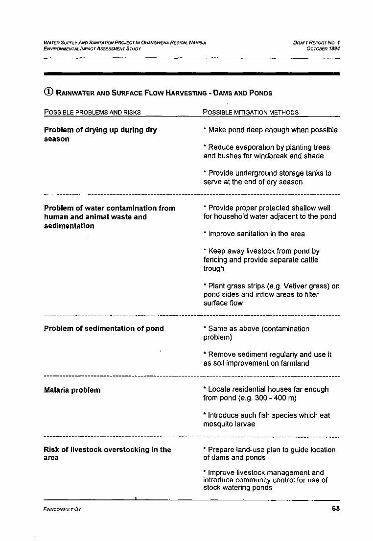
WATER SUPPLY AND SANITA TIONPROJECT IN OHANGV~ENAREGION, NAMIBIAENVIRONMENTAL IMPACTASSESSMENT STUDY
DRAFT REPORTNO IOCTOBER1994
RAINWATER AND SURFACE FLOW HARVE
POSSIBLE PROBLEMS AND RISKS
STING - DAMS AND PONDS
POSSIBLE MITIGATiON METHODS
Problem of drying up during dry * Make pond deep enough when possibleseason
* Reduce evaporation by planting treesand bushes for windbreak and shade
* Provide underground storage tanks toserve at the end of dry season
Problem of water contamination from * Provide proper protected shallow wellhuman and animal waste and for household water adjacent to the pondsedimentation
* Improve sanitation in the area
* Keep away livestock from pond by
fencing and provide separate cattletrough
* Plant grass strips (e.g. Vetiver grass) onpond sides and inflow areas to filtersurface flow
Problem of sedimentation of pond * Same as above (contaminationproblem)
* Remove sediment regularly and use itas soil improvement on farmland
Malaria problem Locate residential houses far enoughfrom pond (e.g. 300 - 400 m)
* Introduce such fish species which eatmosquito larvae
Risk of livestock overstocking in the Prepare land-use plan to guide locationarea of dams and ponds
* Improve livestock management andintroduce community control for use ofstock watering ponds
FINNCONSULTOY 68


WATER SUpPLYAND SANITATION PROJECT IN OHANGWENA REGION, NAMIBIAENVIRONMENTAL IMPACTASSESSMENT STUDY
DiwT REPORTNo IOCTOBER 1994
Possible additional benefits:
* Pond increases groundwater recharge* Pond provides possibilities for fish farming* Sediment can be used for soil Improvement on cropland
© SHALLOW HAND DUG WELLS
POSSIBLE PROBLEMS AND RISKS POSSIBLE MITIGATION METHODS
Small yield and limited amount of * Spatial dispersion of wells, selection ofwater in aquifer favourable sites and use of alternative
sites
Contamination of well water * Develop proper design and constwctcarefully
* Prevent children from throwing rubbishin well
* Use chemical purification methods
* If windlass lifting system, use clean
buckets and ropes
Special benefits:
* Cheap and labour intensive, easy to operate* Gives better opportunities to control livestock numbers
© DEEP HAND DUG WELLS
Problems and risks as for shallow wells, but more costly and more difficult to construct.Higher risk of collapsing than with a shallow well.
POSSIBLE PROBLEMS AND RISKS POSSIBLE MITIGATION METHODS
High salinity of aquifers * Develop low-cost desalination facilities
FINNCONSULT Ov 69

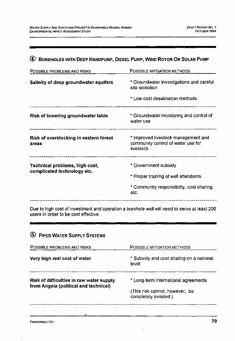
WATER SUPPLYAND SANITATION PROJECT IN OHANGVV~NAREGION, NAMIBIA
ENVIRONMENTAL IMPACT ASSESSMENT STUDYDRAFT REPORTNO I
OCTOBER 1994
BOREHOLES WITH DEEP HANDPUMP, DIESEL PUMP, WIND ROTOR OR SOLAR PUMP
POSSIBLE PROBLEMS AND RISKS POSSIBLE MITIGATION METHODS
Salinity of deep groundwater aquifers * Groundwater investigations and careful. site selection
* Low-cost desalination methods
Risk of lowering groundwater table * Groundwater monitonng and control ofwater use
Risk of overstocking in eastern forest * Improved livestock management andareas community control of water use for
livestock
Technical problems, high cost, * Government subsidycomplicated technology etc.
* Proper training of well attendants
* Community responsibility, cost sharingetc..
Due to high cost of investment and operation a borehole well will need to serve at least 200users in order to be cost effective.
© PIPED WATER SUPPLY SYSTEMS
POSSIBLE PROBLEMS AND RISKS POSSIBLE MITIGATION METHODS
Very high real cost of water * Subsidy and cost sharing on a nationallevel
Risk of difficulties In raw water supply * Long-term international agreementsfrom Angola (political and technical)
(This risk cannot, however, becompletely avoided.)
FINNCONSULT OY 70

*

WATER SUPPLYANO SANITATION PRO.JECTIN OHANGI4�NA REGION, NAMIBIAENVIRONMENTAL IMPACTASSESSMENTSTUDV
RAINWATER CATCHMENT FROM ROOFS INTO RESERVOIRS
* This method is economical and environmentally sound, but it requires modern ironsheetor concrete roofing. Does not apply for thatched roofs.
* A 200 m2 roof may provide up to 80 m3 water annually. Reservoir capacity limits
collected amount.
DP~FTREPo~TNOIOcToBER 1994
Adverse environmental Impacts ofcanals In bulk water supply system
* Improved canal design or undergroundpipelines when crossing oshanas
* Fencing and control of livestockwatering
Risk for too heavy concentration of * Effective land-use planning necessarywater points and human settlements to guide location of water suppliesand consequently increasingenvironmental degradation * Careful siting of water points
* Community control of livestock watering
Tendency of increasing wastage of * Water charges should be increasedwater closer to real costs
Contamination caused by sewage and * Proper waste water treatment plants towaste water be constructed
FINNCONSUL r O~ 71

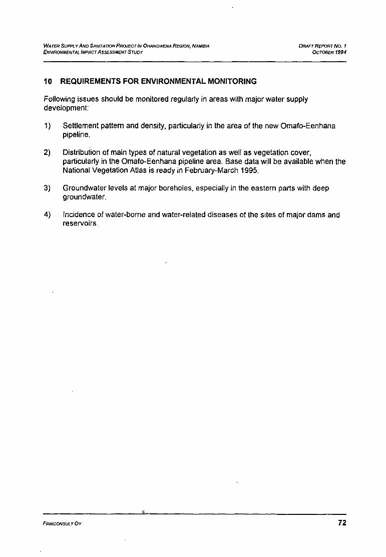
WA TER Suppi. v AND SANITATION PROJECT IN OHANGWENA REGION, NAMIBIA DRAFT REPORTNo. IENVIRONMENTAL IMPACTASSESSMENTSTUDY OCTOBER1994
10 REQUIREMENTS FOR ENVIRONMENTAL MONITORING
Following issues should be monitored regularly in areas with major water supplydevelopment:
1) Settlement pattern and density, particularly in the area of the new Omafo-Eenhanapipeline.
2) Distribution of main types of natural vegetation as well as vegetation cover,particularly in the Omafo-Eenhana pipeline area. Base data will be available when theNational Vegetation Atlas is ready in February-March 1995.
3) Groundwater levels at major boreholes, especially in the eastern parts with deepgroundwater.
4) Incidence of water-borne and water-related diseases of the sites of major dams andreservoirs.
FINNCONSULT Ov 72

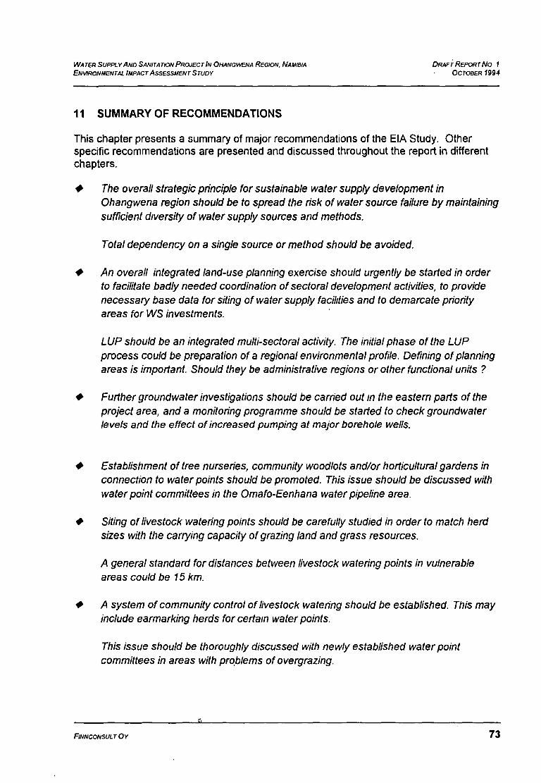
WA TER SUPPLYAND SANITA TIO1V PROJEC TIN OHANGWENA REGION. NAMIBIA DRAFT REPORTNo 1ENVIRONMENTAL IMPACTASSESSMENTSTUDY OCTOBER 1994
11 SUMMARY OF RECOMMENDATIONS
This chapter presents a summary of major recommendations of the EIA Study. Otherspecific recommendations are presented and discussed throughout the report in differentchapters.
• The overall strategic principle for sustainable water supply development inOhangwena region should be to spread the risk ofwater source failure by maintainingsufficient dIversity ofwatersupply sources and methods.
Total dependency on a single source or method should be avoided.
• An overall integrated land-use planning exercise should urgently be started in orderto facilitate badly needed coordination ofsectoral development activities, to providenecessary base data for siting of water supply facilities and to demarcate priorityareas for WS investments.
LUP should be an integrated multi-sectoral activity. The initial phase of(he LUPprocess could be preparation ofa regional environmental profile. Defining ofplanningareas is important. Should they be administrative regions or other functional units?
• Furthergroundwater investigations should be carried out in the eastern parts oftheproject area, and a monitoring programme should be started to check groundwaterlevels and the effect of increased pumping at major borehole wells.
• Establishment oftree nurseries, community woodlots and/orhorticultural gardens inconnection to waterpoints should be promoted. This issue should be discussed withwater point committees in the Omafo-Eenhana waterpipeline area.
* Siting of livestock watering points should be carefully studied in order to match herdsizes with the carrying capacity ofgrazing land and grass resources.
A general standard for distances between livestock watering points in vulnerableareas could be 15 km.
* A system ofcommunity control of livestock watering should be established. This mayinclude earmarking herds for certain waterpoints.
This issue should be thoroughly discussed with newly established waterpointcommittees in areas with problems ofovergrazing.
FINNCONSULTOY 73


WATER SUPPLYAND SANITATION PROJECT IN 0HANG~NAREGION, NAMIBIA D~AI~TREPORT No IENVIRONMENTAL IMPACT ASSESSMENT STUDY OCTOOER 1994
0 New major surface waterponds and open reservoirs should not be located close tohomesteads in order to reduce malaria hazard. A safety distance of200 - 400 m(depending on topography and wind directions) is recommended.
Fish farming in water ponds and dams should be promoted. Experiences gained bythe Rural Development Centre (RDC) in fish farming should be studied.
• Removal ofsediment from ponds and dams should be promoted. Removed siltshould be used as fertilizeron cr0plandprovided that salinity is not too high.
Desalting large ponds could be done as community food-for-work campaigns in thelate diy season.
O Methods ofrainwater catchment should be further developed. Water tanks forrainwater collection from ironsheet roofs in semi-urban areas should strongly bepromoted. There is a potential for collecting up to 300 000 m3 ofrainwater annuallyfrom ironsheet roofs within the project area. Particularly important are hospitals,schools, clinics and otherpublic, communal and commercial buildings.
O Possibilities for the construction of covered or underground water tanks in connectionwith open ponds and reservoirs, to serve for the late diy season when reservoir hasdried up, should be investigated. (Ferrocement, ironsheet orplastic tanks, buriedlarge-diameterPVC pipes, etc.)
O The possibilities to use small-scale low-cost desalination facilities in order to be ableto use saline groundwater for household needs should be investigated. A few testingplants should be constructed in selected locations within the project area.
FINNCONS~JLTOv 74


ANNEX I
TOR for EIA stuy

AAIIVEX ~1•
19.1.1994TERMSOFREFERENCE1
ENVIRONMENTAL IMPACT ASSESSMENT STUDY
1. INTRODUCTION/OBJECTIVE
According to the SecondDraft of the Nan]ibia’s EnvironmentalAssessment Policy it is to be ensuredthat “the environmentalconsequencesof developmentprojectsandpolicies areconsidered,understoodandincorporatedinto theplanningprocess,and that thetermENVIRON~.[ENTis broadlyinterpretedto include biophysical~social, cultural, historicalandpolitical components.”Therefore the Consultantis responsiblefor preparingtherequiredEnvironmentalImpact Assessment.The objectiveof thestudyis to makepossibleto incorporatethe environmentalissuesinto the WaterSupplyandSanitationDevelopmentPlanandAnnual Work Plansof the project.
2. ETA GUIDELINES
The above mentionedNamibia’s EnvironmentalAssessmentPolicy wul be the main guideline inpreparing the ETA Also the Guidelines for EnvironmentalImpact Assessmentin DevelopmentAssistance/FINNIDA will be usedv.hereapplicable.
3. BACKGROUND INFORMATION
The Namibia-FinlandWaterSupplyandSanitationDevelopmentCooperationProjectin OhangwenaRegioncommencedon 1992.Theproject’smain objectiveis to improvethewatersupplyandsanitationservicesin the ruralareain the Westernpartof OhangwenaRegionandto preparethe WaterSupplyand SanitationDevelopmentPlan for the project area.The projecthasbeenimplementedby theDirectorateof Rural Developmentunderthe Ministry of Agriculture, WaterandRural Development.DevelopmentassistanceServiceshave beenprovided by Finnconsult.The Project Documentwasrevisedduring 1993 andapproved1.12.1993andin the newdocumentthe Directorateof RuralWaterSupplyunderthe Departmentof WaterAffairs took over the implementationresponsibility.During 1992-1993 the projecthascarriedout experimentalconstructionandthe basicinventoriesandstudiesfor the formulationof the watersupplyandsanitationdevelopmentplan.The projectareacovers3880 km2 havinga populationof about 125 000 people.Majority of the ruralpopulationis collecting water from open shallow water holes (Ndungu
1Omifima). Theseholes areunprotectedandwill usually dry up endof thedry season.During theraL-~iyseasonopenholesarefilledwith rain water havinghigh concentrationsof solidsandbacteria..The livestock (mainly cattle,goatsanddonkeys) is watered throughdamsduring the rainyseasonandendof the dry seasonmostof thecattle is movedto the cattlepostsEastof OhangwenaRegion.Accordingto theinventoriesthat projectareais havingabout2 200 ndungusandomifitus andabout300 protectedwells. The Herringbonepipedwatersystemoperatedby DWA is providingwater to thepopulationin growing pointsandalongthe main roads.
Mostof the rural populationarewithout propersanitationfacilities. Only 7 % of the rural populationis havingsomekind of sanitationfacilities andonly 3 ~ is havingVIP latrines of flush toilets.
1b,eiator. jan


2
The following projectsareactive in the area:DiocesanWaterProject:
Constructionof shallowwells with concreteringsequippedwith handpumps.DevelopmentBrigadeCorporation
Constructionof dams equippedwith handpumpsfor humanand livestockconsumptionseparately.
Rural DevelopmentCentreConstruction of shallow wells with concrete rings and equipped withhandpumps.Constructionof damsfor livestockwatering.Drilling of shallowboreholesand equipped with handpump.Selling of VIP latrines.
UNICEF with WSSPORConstructionof roofcatchmentsequippedwith ferro-cement.watertanksandVIP latrines.
DWADrilling of boreholesthrough the Drought Relief Programme.Operation,rehabilitationandconstructionof ruralwater pipedschemes.
Foodfor WorkConstructionof small communitydarns
WSSPORProtectionof communalshallow wells equippedwith bucket lifting system.Drilling of shallow boreholesequippedwith handpump.Constructionof VIPlatrinesfor institutionsandprivate.
The studiesandreportsavailablehavebeenlisted in ANNEX 1.
The WaterSupplyandSanitationDevelopmentPlanproposalwill be readyendof March 1994.Theproposalwill contain all backgroundinformationandoverall guidelinesand technologrchoiceof theproposedconstructionmethodsfor the projectarea.
4. SPECIFICEDt GUIDELINES
Underthe supervisionof theWaterSupplyandSanitationProjectandDepartmentof WaterAffairsandin cooperationwith theMinistry of Wildlife, ConservationandTourismwill preparetheETA reportconsistingof thefollowing
* ExecutiveSummaryContents
* IntroductionMethodolo~rof the ETA including-.
- identification and interviews of interested andaffectedparties
- identification andsummpryof availabledatabasis.• possiblesite visits (expectedto take time about 2-3
weeks)- analysisof field dataand comparisonwith existing
literature* Assumptionsand limitations
Descriptionof the proposedprojectsinduding• needandjustification of the project- how the projectfits into regionaldevelopmentplans- contributions of other sectors to the proposed
development- how the project will enhanceor constrain future
developmentoptions


3
conditionsin qualitativeandquantitativeterms of thephysical, biological and socio-economicenvironmentbefore the implementation of the project andpredictionof the environmentaldevelopmentif NOPROJECTimplementationis carriedout.
utilization of perchedground water by developingexistingwaterpointsutilization of deepgroundwaterutilization of surfacewaterthrough pipelinesutilization of surfacewaterthroughstoragedamsdesalinationof groundwateruseof alternativeconstructionmaterialsandmethods
including-- impacton groundwatertable- impact of lowered groundwater table- impact. in landuse around water points- impacton waterrelateddiseases- impact on culturalelements- impact on water pollution and quality (salt water
intrusion)- economicimpacts- impactsduring the construction- impactson public service- impact on local populationsusingnaturalresources- short termandlongterm impacts- direct andindirect impacts- cumulativeimpacts
describe possible mitigatory measures, to reducenegativeimpactsandenhancepositiveimpacts
• Considerand proposeappropriateparametersto bemonitoredfor assessingthe actualimpactsduringtheproject’s operation andbeyond
• Considertherequiredlongtermmonitoringresourcesandpossibleresponsibleorganization(s)
proposeguidelinesfor the forest and oshanaareasrequired in water supply construction
* ExistingEnvironment
* DevelopmentAlternatives
* Positiveandnegativeimpacts
* Possiblemitigation
a Monitoring andEvaluation
* Environmentalguidelines
* Recommendations* Sourcesof dataandinformation* Termsof Reference
5. TiME SCHEDULE
The time scheduleis presented in ANNEX 2.


ANNEX 2
List of Persons and Organizations Consulted

q
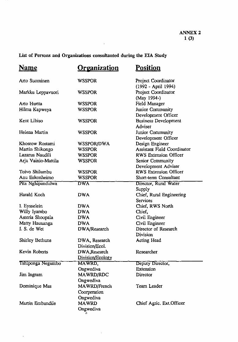
List of Personsand Organizationsconsultantedduring the ELA Study
ANNEX 21 (3)
Name Organization Position
Aflo Suominen
Markku Leppavuori
Arto HurttaHilma Kapweya
Kent Libiso
HelenaMartin
KhosrowRostamiMartin ShikongoLazarusNaudiliArja Vainio-Mattila
Toivo ShilumbuAnu EskonheimoPita Nghipandulwa
Harald Koch
I. EysseleinWilly lyamboAsteriaShoopalaMatty HauuangaI. S. deWet
WSSPOR
WSSPOR
WSSPORWSSPOR
WSSPOR
WSSPOR
WSSPOR/DWAWSSPORWSSPORWSSPOR
WSSPORWSSPORDWA
DWA
DWADWADWADWADWA/Research
DWA, ResearchDivision/Ecol.DWA,ResearchDivision/EcologyMAWRD,OngwedivaMA WRD/RDCOngwedivaMA WRD/FrenchCoorperationOngwedivaMAWRDOngwediva
ProjectCoordinator(1992 - April 1994)ProjectCoordinator(May 1994-)Field ManagerJunior CommunityDevelopmentOfficerBusinessDevelopmentAdviserJunior CommunityDevelopmentOfficerDesignEngineerAssistantField CoordinatorRWS ExtensionOfficerSeniorCommunityDevelopmentAdviserRWS ExtensionOfficerShort-termConsultantDirector, Rural Water —
SupplyChief, Rural EngineeringServicesChief, RWS NorthChief,Civil EngineerCivil EngineerDirectorof ResearchDivisionActing Head
Researcher
DeputyDirector,ExtensionDirector
TeamLeader
Shirley Bethune
Kevin Roberts
TshipongaNegumbo
Jim Ingram
Dominique Mas
Martin Embundile chief Agric. Ext.Officer


2
Emily Handunge MAWRDOngwediva
Chief AEO
Bjom Finne
O.MulitaAntti ErkkilaAnneli ShishomeGunnarBendelinMartinus GelensAndre Koopmans MOETfNational
RemoteSensingCenter(NRCS)
Chiefof EnvironmentDirectorate
DevelopmentDirector
Acting HeadForesterForesterForesterResearchOfficerCoordinator
ChristopherI.Brown Ministry ofEnvironmentandTourismMOETfDirectorateof Forestry
‘I
I,
‘I
I,
Harry Tsipueja Ministry of Lands, Deputy DirectorResettlementand for LandsRehabilitation(MLRR)
Mr D.J. Sheya MLRROndangwa.
RegionalControlOfficer
FlemmingLarsen Ministry of HealthandSocial Services/EAIFIP
ProjectCoordinator
Mr Eloby Amundaba MOHSS Chief Control Officer
Tom Kroll SARDEP ProjectCoordinatorGotpenHamweenye SARDEP ExtensionOfficer
Erkki Putkonen OgongoAgric. College
ForestryTeacher
Carlor Salinas “ LectureOsmanHamid “ LecturePirjo Saramaki “ ProjectCoordinator
Erik Madsen OHSJP,Oshakati ProjectCoordinator
Mary Seely EnvironmentalEvaluationAssociatesofNamibia
Researcher
WabombaSingoro VWL NamibiaInc Civil Engineer


Markku AhoMarkku Laamanen
Ecro KontulaJukkaUosukainenJuhaniToivonen
Veil Pohjonen
FINNIDAFINNIDA
FINNIDAFINNIDAFINNIDAEmbassyofFinland,WindhoekUniversity ofJoensuu
CounsellorDeskOfficer forNanilbiaAdvisor (Water Supply)Advisor (Environment)Counsellor
Professor
3


ANNEX 3
Literature and References
r.


1
ANNEX 31 (10)
LIST OF LITTERATURE AND DOCUMENTS USED IN THE EIA STUDY
Board on Scienceand Technologyfor internationalDevelopmentVetiver Grass- A thin greenline againsterosion.Washington,1993
Botelle, A
A Socio- EconomicSurveyof OnaandaRoadConstructionProjectin WesternOwambo. Namibian Institute for Social and Economic Research(NISER)IUNAM. Windhoek,1991
BreldanConsultantsLtd.
Environmentaland Socio - EconomicAppraisal of the Kerio Valley LDP
proposedSub-Project.Nairobi,1992
Christiansson,C.
Soil Erosionand Sedimentationin Semi-AridTanzania.ScandinavianInstituteof African Studies,Uppsala, 1981.
Cook, C. & Grut, M.
Agroforestry in Sub-SaharanAfrica, A Farmers’sPerspective.World BankTechnical paperNo 112 WashingtonD.C., 1989.
Critcbley, W.
How Africa’s PastoralistsCatchtheRain. Ceres,September-October1990.
DANIDA
- A strategyfor Agriculture, Livestock Husbandryand Forestryin Arid andSemi-Arid Areas.Copenhagen,1988.A strategyfor WaterResourcesManagement.Copenhagen,1988.
Darkob, M.B.
LandDegradationandResourceManagementin Kenya.DesertificationControlBulletin (UNEP), No 19,1991.

2
District DevelopmentFund, Zimbabwe
Well sinking - A Step by Step Guide to the Construction of wells. Harare,1992.
Drummond, R.B. & Paigrave,K.
CommonTreesof the Highveld. LongmanZimbabwe,Harare,1990.
EnvironmentalEvaluationAssociatesof Namibia (PTY)Ltd
Environmental ImpactEvaluationof Ogongo- OshakatiWaterSupplyProject.Windhoek,1992.
Erkkila, A. & Silskonen, H.
Forestryin Namibia 1850 - 1990.University of Joensuu,Faculty of Forestry,Joensuu,1992.
ESCAP/UnitedNations
Environmental Impact Assessment- Guidelines for Water ResourcesDevelopment.New York, 1990.
FAO, Food and Agriculture Organizationof the United Nations.
CaseStudiesfrom Farm Forestryand WastelandDevelopmentin Gujarat,India. Bangkok, 1989.
FAOGuidelinesfor the Control of Soil Degradation.Rome, 1983.
FAO & WAD
Naniibia, Northern Regions Livestock Development Project, Summary.Windhoek,1992.
Finmsh InternationalDevelopmentAgency (FINNIDA)
- Guidelineson Environmental ImpactAssessmentin DevelopmentAssistance.Helsinki, 1989.
- Guidelinesfor Project Preparationand Design.Helsinki, 1991.- Forestry Development in Namibia, Report of Project Identification and
PreparationMission. Helsinki, 1990.


3
FriedrichEbertStiftung
NanübiaRegionalResourcesManual.Windhoek,1994.
Franco-Namibian Rural DevelopmentSupport Project.
FarmingSystemsAnalysis Support Mission. Paris, 1993.
Fries, I.
Managementof Natural Forestsin the Semiarid Areas of Africa. Ambio,December,1991.
Furness et al.
AgroforestryExtensionTraining Manual.Agritex, Harare,1985.
Gorse,I.E. & Steeds,D.R.
Desertificationin theSahelianandSudanianZonesof West Africa. The WorldBank Washington,1987.
Grainger, A:
TheThreateningDesert,Controlling Desertification.Earthscan,London, 1990.
Groundwater ConsultingServices(PTY)Ltd. (For DWA)
Central Owambo-GeologicalHistory, Basin Evolution and GroundwaterReservesand Resources.Windhoek,1992.
Hauuanga, M.
Rural Water Supply Optionsin OhangwenaRegion,Namibia. (Essay).LoughboroughUniversityof Technology,1994.
Halofu S.
Interview-basedGroundwaterInvestigationfor Water Supply in OhangwenaRegion,Namibia. (Essay).TampereUniversityof Technology,1992.
Harrison,P.
The Greeningof Africa - Breakingthroughin the Battle for Landand Food.IED-Earthscan,London, 1987.

4
Hjort, A. (ed.)
Land Managementand Survival. ScandinavianInstitute for African Studies,Uppsala, 1991.
Hjort af Ornas,A. & Salih, M.
Researchand DevelopmentIssuesfor African Drylands.Ambio, December1991.
IBIS/WUS Denmark
Support to the Ministry of Lands, Resettlementand Rehabilitation(MLRR)with Respectto Land usePlanningand LandAdministration.ProjectReview.Windhoek,1994.
InternationalConservation Union (IUCN)
The 1UCN Reviewof theSouthernOkavangoIntegratedWaterDevelopment
Project (SOIWDP). Gabrone,1992.
Janson, S.D.
EnvironmentalProfileof Namibia.Reportpreparedfor SIDA. Windhoek,1993
Janssen,G. ,Yaron, G. & Maaniberna,U.
Rural Developmentin the Okavango Region of Nanilbia. Gamberg andMacmillan,Windhoek,1992.
Katjiua, M. ,Healy,T. & Forbes-Irving,T.
Managing Boreholes and Grazing Areas in Namibia/Okavango.DesertResearchFoundationof Naniibia (DERU). Windhoek,1993.
Kerkbof, P. (ed)
Agroforestry in Africa. A Surveyof Project Experience.Panos Institute.London. 1990.
Kolberg, Herta
Acaciasof SWA/Namibia.Windhoek,1989.
Lau, B. & Reiner, P.
100 Yearsof Agricultural Developmentin Colonial Namibia, Archeia 17.Windhoek,1993.


5
Le Beau,D. AND Pendleton,W. C.
A Socio-Economicand BaselinesDesk-top Study of Health, Water andSanitation. The Namibian Institute for Social and Economic Research(NISER)/UNAM. Windhoek,1992.
Madany, M.
Living Fences.AgroforestryToday,January-March1991.
Marsh, A. & Seely,M. (ed)
Oslianas - Sustaing People, Environment and Development in CentralOwambo, Namibia. DesertResearchFoundationand SIDA. Windhoek,1992.
Maydell, H-J.
Agroforestry in the Dry Zones of Africa: Past, Present and Future. (In)Agroforestry,A Decadeof Development,ICRAF, Nairobi. 1987.
Ministry of Agriculture, Water andRural Development
- Deforestationand Soil Fertility Problemsin the West of OhangwenaRegion. (ByFabriceRenaudand HannuPelkonen).Ongwediva,1994.
- Draft Project Proposal on AgroforestryDvelopmentin Owambo (for FINNJDA).Windhoekand Helsinki, 1992.
- NorthernRegionsDevelopmentProgramme(NRDP), Draft Final Report,Vol. 1 and2 Windhoek,1993.
- Rural DevelopmentProject for Northern Namibia, Presentationof the Project.Windhoek, 1993.
- Sustainable Animal and RangeDevelopmentProgrammein the CommunalAreasofNamibia (SARDEP). Windhock~1993.
Ministry of Agriculture, Water andRural Development,Department of Water Affairs (DWA)
- A Socio-EconomicOverview of the Ogongo-OshakatiRegionalStateWaterScheme.NamibiaInstitutefor Social andEconomicResearch(NISER), Universityof Namibia,Windhoek, 1992.
- Central Area Water Master Plan, Phase 1,Vol. 9. Environmental Aspects.CESJLCE/WCE Consultants. Windhoek,1993.

6
- Extensionof Rural WaterSupply Networkalongthe Omafo-Eenhanapipelinein the
OhangwenaRegion.Internal PlanningMemorandum.Windhoek,1993.- National Water Supply and SanitationSectorPolicy of the Governmentof Naniibia.
Windhoek~1993.
- Perspectiveon Water Supply in Namibia.Windhoek,1990.
- RegionalMasterWater Planfor theOwamboRegion.Windhoek,1990.
- Rehabilitationof Eight EarthDamsin OwamboRegion.DevelopmentBrigade,1992.
- Report for the Dam ConstructionProgrammeOwambo/Kaoko.RDC. Ongwediva,1993.
Ministry of Agriculture, Water and Rural Developmentand FINNIDAReports and documents of the Water Supply and Sanitation Project in ObangwenaRegion (WSSPOR)
- A Socio-Economicand BaselineDesk-TopStudy of Health,Water and Sanitation.NISER, University of Namibia, 1993.
- Annual ProgressReports, 1992and 1993.
- Desk Study Report. Interconsult Narnibia (PTY), Windhoek,1992.
- Investigationinto the SurfaceWaterResourcesof Owambo,1991. Windhoek,1991.
- Memorandumon the Workshopon Environmental Impact Assessment,May 26-27
1994 in Ongwediva.- Reporton theresultsof Boreholedrilling in OhangwenaRegion.Ongwediva,1993.
- RevisedProjectDocument,December1993.
- Water Supply and SanitationDevelopmentPlanfor the WesternPart of OhangwenaRegion,First Draft, Volume 1, Summary,Finnconsult,1994.
- WaterSupplyDevelopmentPlanfor theWesternPartof OhangwenaRegion,Volume3; WaterResourceAssessment. InterconsultNamibia (PTY), Windhoek,1994.
- Work Plan 1994.
Ministry of Environment and Tourism
- Namibia’sEnvironmentalAssessmentPolicy. Windhoek,1993.
- Namibia’sGreenPlan,Environmentand Development(Draft), Windhoek,1994.


7
Ministry of Local Government and Housingand WUS Denmark.
Assistanceto HumanSettlementsImprovementsin the OshakatiRegion.Windhoek,1992.
Mthoko, A. ,Noisser,N. & Rebentisch, M.
Geographyof Namibia. Gamsberg& Macmillan.Windhoek,1990.
Mungongo, C.
Socio - Ecological Processesand the Land Questionin the KondoaIrangi Hills,Tanzania.Ambio, December1991.
Makela P.
KestavaankehitykseenitsenaisessaNamibiassa- ymparistoprojekti.Projektiraportti.Helsinki, 1990.
Makela, P. & Williams, F-N
SocialandEconomicConsequencesof a SmallVillage Olukeno;Problemsof Colonial
Developmentin Namibia. (Study Report).Universityof Joensuu,1990.
Nair, P.K.R. (ed)
AgroforestrySystemsin theTropics.KiuwerAcademicPublishers.Doordrecht,1989.
Namib EducationGroupfDesertResearchFoundation
Waterin Namibia,A ResourcePackageto DevelopAwarenessof Water. Windhoek,1992.
Ngunjiri, P.
In a Dry Land,Reporton theTurkanaRural DevelopmentProgramme,Kenya. PanosInstitute.London, 1987.
Omoro, B.
MarginalSoil, MarginalFarms.A Reportof theMutomoSoil andWaterConservationProgrammein Kenya. PanosInstitute.London, 1987.
Piearce, G.D.
TheZambeziTeakForests.Proceedingsof theFirst InternationalConferenceonTeakForestsof SouthernAfrica. The Forest Departmentof Zambia/FINNIDA. Ndola,1986.


8
Republic of Namibia, National Planning Commission.
- TransitionalNationalDevelopmentPlan 1991/92-1993/94.Windhoek,1993.
- 1991 Populationand HousingCensus.CentralStatisticsOfficer, Windhoek,1992.
RuralDevelopment Centre, Ongwediva(RDC)
Presentationof Activities 1993.
Ronkko, M.
Proposalfor Pilot Projectof CompostiveSanitationin Namibia.Helsinki, 1992.
Salaheldin, G.H.
Environmental Degradation in A Semi-arid Range Land in Northern Sudan.DesertificationControl Bulletin (UNEP),No 19, 1991.
Scoones,I.
Wetlands in Drylands: Key Resourcesfor Agricultural and PastoralProductioninAfrica. Ambio, December1991.
Seely,M.
NamibIa, Drought and Desertification. Gasmberg& Macmillan Publishers(PTY).Windhoek1991.
Shikongo,M.
People’s Participation in Water Projects. A Study of OhangwenaWater Project,Namibia. (Essay)TampereUniversityof Technology,1992.
Skarpe,C.
Impactof Grazingin SavannaEcosystems.Ambio, December1991.
South-West Africa Administration, Water Affairs Branch
Registerof Dams in Ovamboland.Windhock, 1963.
Stern,C. & Lau B.
NamibianWaterResourcesandtheirManagement- A PreliminaryHistory. Archeia.Windhoek,1990.


9
Stiles, D.
Arid Lands Plants for Economic Development and Desertification Control.DesertificationControl Bulletin (UNEP),No 17, 1988.
Stuart,C. & T.
Southern,CentralandEastAfrican Mammals,A PhotographicGuide. New HollandPublishers.London 1992.
Tapscott, C.
The Social Economyof Livestock Productionin the Owambo Region. NamibianInstitute for Socialand EconomicResearch(NISER)/UNAM. Windhoek,1990.
Thunberg I.
Village Nurseriesfor ForestTrees.SIDA. Stockholm, 1984
Toulmin, C.
GestiondeTerroir,Principles,First LessonsandImplicationsfor Action. InternationalInstitute for EnvironmentalGuidelinesfor WatershedDevelopment.London, 1993.
United Nations EnviromnentProgramme(UNEP)
EnvironmentalGuidelinesfor WatershedDvelopment.Nairobi, 1982.
UNSO, United NationsSudano-SahelianOffice
AlternativeandSustainableSystemsof ProductionandLivelihoodsinMarginal Lands.New York, 1992.
van Wyk, P.
SouthernAfrican Trees.A PhotographicGuide. Struik Publishers.CapeTown, 1993.
Wenner,C-G
Some Guidelines for Planning of Soil Conservation. Swedish University ofAgricultural Sciences.Uppsala,1989.
WinpennyI.T.
Valuefor theEnvironment- A Guideto EconomicAppraisal,HMSO.,London, 1991.


10
World bank
- EnvironmentalAssessmentSourcebook,VolumeII: SectoralGuidelines.WashingtonD.C., 1991.
- Sub-SaharanAfrica; From Crisis to SustainnableGrowth. Washington D.C. 1989.
- Agriculture in Namibia. Washington D.C., 1990.
MAPS
- SouthWestAfrica, TopographicalSheets1/250000. 1714 Oshakati,1716 Eenhana.Windhoek1975.
- OhangwenaRegionTopographicMaps 1/20000.MT-SurveyLtd, Jarvenpaa,Finland,1993 (28 sheets).


ANNEX 4
Itinerary and Work Programme


ANNEX 5
Photographs


![MlV]H - IRC · 'Governance' - Nanda Abeywickrama 2c. ... problems of global water scarcity. ... Sanitation Non-revenue water](https://img.dokumen.tips/doc/110x75/5b53fff37f8b9a45298c6fe8/mlvh-irc-governance-nanda-abeywickrama-2c-problems-of-global-water.jpg)