Embed Size (px)
Citation preview
Journal of Hydrology 420–421 (2012) 264–274
Contents lists available at SciVerse ScienceDirect
Journal of Hydrology
journal homepage: www.elsevier .com/locate / jhydrol
Water source utilization by woody plants growing on dolomite outcropsand nearby soils during dry seasons in karst region of Southwest China
Yun-peng Nie a,b,c, Hong-song Chen a,b,⇑, Ke-lin Wang a,b, Jing Yang a,b,c
a Key Laboratory of Agro-ecological Processes in Subtropical Region, Institute of Subtropical Agriculture, Chinese Academy of Sciences, Changsha 410125, Chinab Huanjiang Observation and Research Station for Karst Ecosystems, Chinese Academy of Sciences, Huanjiang, Guangxi 547100, Chinac Graduate School of Chinese Academy of Sciences, Beijing 100039, China
a r t i c l e i n f o
Article history:Received 17 January 2011Received in revised form 13 October 2011Accepted 5 December 2011Available online 13 December 2011This manuscript was handled by PhilippeBaveye, Editor-in-Chief, with the assistanceof Tamotsu Kozaki, Associate Editor
Keywords:Dolomite outcropWater sourceKarst regionDry seasonStable isotopesIsoSource
0022-1694/$ - see front matter � 2011 Elsevier B.V. Adoi:10.1016/j.jhydrol.2011.12.011
⇑ Corresponding author at: Key Laboratory of ASubtropical Region, Institute of Subtropical AgricuSciences, Changsha 410125, China. Tel.: +86 731 8461
E-mail address: [email protected] (H.-s. Chen).
s u m m a r y
In the seasonally dry karst region of Southwest China, woodland vegetation is frequently associated withrocky outcrops. We used stable isotope techniques to determine the water sources of two woody plantspecies (the semideciduous tree Rademachera sinica and the deciduous shrub Alchornea trewioides) acrossthree surface types: continuous and isolated dolomite outcrops, as well as adjacent surfaces with soils.Main water sources for R. sinica growing on the continuous outcrops shifted from deep water sources(e.g., water in the saturated zone) on March 23, 2009 (the late dry season of 2008–2009) to rainwaterstored in rock fissures of the unsaturated zone on November 8, 2009 (the early dry season of2009–2010). R. sinica growing on nearby thin soils exhibited a similar shift of main water sources, fromdeep water sources in the late dry season to shallow soil water (0–30 cm) in the early dry season.However, they extracted deep water sources from the bottom of nearby outcrops rather than from deeperlayers below the soil surface. Main water sources for R. sinica growing on the isolated outcrops shiftedfrom previous (one to two months ago) rainwater in the late dry season to the mixture of recent (withinthe last one month) and previous rainwater in the early dry season, while using little or no deep watersources. In contrast, A. trewioides growing on these two kinds of outcrops always relied on recent rainwa-ter, while those growing on soils always relied on shallow soil water. The shift of water sources for treespecies (especially those growing on continuous rock outcrops and nearby soils) may allow them tomaintain normal transpiration throughout the year, which increases the amount of evapotranspirationin the watershed and further enhances the water storage capacity of the study area.
� 2011 Elsevier B.V. All rights reserved.
1. Introduction
Southwest China is home to one of the largest karst regions(here and elsewhere) in the world, with an area of approximately500,000 km2 (Yuan, 1994). This area is characterized by rockydesertification with a high ratio of bedrock outcrop to shallow soiland low vegetation cover. The characteristics of rocky desertifica-tion together with the ‘‘dual’’ conduit and diffuse flow systems ofkarst aquifers contribute to the rapid hydrological processes (rapidpenetration of rainwater through thin soil layer and connected fis-sures in bedrock layer to below the rooting zone or groundwater)of the area (Butscher and Huggenberger, 2009), as well as frequentflood/drought events.
Although this area is considered a subtropical region, with totalannual precipitation exceeding 1000 mm, plants endure
ll rights reserved.
gro-ecological Processes inlture, Chinese Academy of5226.
4–5 months of annual drought. Still, naturally reforested bedrockoutcrops tend to thrive. Forest restoration increases the relativecontribution of plant transpiration to evapotranspiration, and reg-ulates the karstic hydrological process (Asbjornsen et al., 2011).Therefore, detailed observations of water sources used by rockyhabitat plant species, especially during the dry season, can providedata for estimating effects of forest restoration on water balance.Many authors have revealed the type and diversity of plants grow-ing on rock outcrops (Burgman, 1987; Anderson, 1999; Crow andWare, 2007; Ware, 2010), however few have focused on sourcesof water used by plants and have examined the hydrological char-acteristics of these forests.
Plant water sources can be determined through stable isotopeanalysis of stem water (Dawson et al. 2002), and this techniquehas been widely used in determining water sources used by plants(Brunel et al., 1995; Meinzer et al., 1999; Schwinning et al., 2003;Querejeta et al., 2006, 2007; Asbjornsen et al., 2007; Hasselquistet al., 2010; Nie et al., 2011). There is no isotopic fractionation dur-ing water uptake by terrestrial plants, although examples of plantspecies that seem to fractionate hydrogen (but not oxygen) during
Y.-p. Nie et al. / Journal of Hydrology 420–421 (2012) 264–274 265
water uptake exist (Lin and Sternberg, 1993; Ellsworth andWilliams, 2007). Water sources can be pinpointed by comparingthe isotope ratios of all potential water sources with water ex-tracted from plant stems (Dawson et al., 2002).
Rose et al. (2003) found that both pine and manzanita growingon thin soil underlain by weathered granitic dolomite predomi-nantly used surface soil water (0–75 cm), and exploited dolo-mite-derived water when soil water was depleted. McCole andStern (2007) found that in thin soils over karstified carbonate bed-rock, water sources of juniper changed from dominantly deepwater during a hot, dry summer to dominantly soil water duringa cool, moist winter. Schwinning (2008) found that tree speciesin karst savannas used water stored in the epikarst zone ratherthan groundwater. However, little is known about water sourcesutilized by plants growing on bedrock outcrops, or the differencebetween species growing on outcrops and nearby soils.
Rooting habit is an important factor affecting water use pat-terns of plants. Zwieniecki and Newton (1994, 1995) found thatin thin soils underlain by thick zones of weathered bedrock, rootsof some species were restricted in thin soil layer, while otherscould exploit water held in bedrock by growing roots into and fol-lowing joint fractures. Zwieniecki and Newton (1996) verified thattwo conifer species showed limited ability to utilize water frombedrock even during dry periods. Ericaceous plants, on the otherhand, were very efficient in taking water from deep rock layers,using nearly all available water and removing twice as much wateras conifers of the same age. Hubbert et al. (2001) and Rose et al.(2003), both suggest that water stored in bedrock was especiallyimportant to pine relative to manzanita as active roots of manza-nita were restricted to the upper 100 cm.
In karst regions, plant root distribution is strongly influenced bysoil depth and epikarst structure (Schwinning, 2008). The epikarst(also known as the subcutaneous zone) is highly weathered car-bonate bedrock that is either exposed or immediately beneaththe surface (Williams, 2008). In some areas of Southwest Chinawhere bedrock is dominantly dolomite, soil is thin and the depthof the epikarst is usually restricted to a few meters, which hampersroot growth (Cao and Yuan, 2005). However, when dolomite is ex-posed (usually manifested by ubiquitous cracks and crevices), itadds to the thickness of the epikarst. Thus, the same species grow-ing in soils and on dolomite outcrops may have different watersources. Two kinds of outcrops are commonly encountered in dolo-mite-dominated areas of Southwest China, continuous and iso-lated. It is well known that water storage capacity of epikarstdepends upon its thickness and continuity. Although there mightbe no difference of thickness between the epikarst of continuousand isolated outcrops, they could be separated from each otheraccording to the continuity of their epikarst. Continuous outcropcould be regarded as a combination of dozens (if not hundreds)of isolated ones, water could transmit between adjacent onesthrough connected fissures under the influence of gravity and/orpore water pressure. The widely distributed lateral flow of waterin continuous outcrop, contrary to the dominated vertical flow inisolated outcrop, extend the residence time of water in epikarst(which is equal to relatively high water storage capacity) and sat-urated zone is more likely to be formed in there. Thus, the samespecies on continuous and isolated outcrops may have differentwater sources. Roots of some species may penetrate through jointfractures and exploit water held there, while others may not. Spe-cies of different root systems in the same habitat may have differ-ent water sources, too. To test these theories, we conducted anisotopic study during Southwest China’s dry seasons to determinethe sources of water used by plants in different habitats. Two com-monly encountered woody species, Radermachera sinica (a semide-ciduous tree that lose part of its foliage in the dry season) andAlchornea trewioides (a deciduous shrub but can leaf out at the
end of dry season if there is rain) were chosen. We hypothesizedthat the tree exhibits deeper root system than the shrub.
2. Materials and methods
2.1. Study area
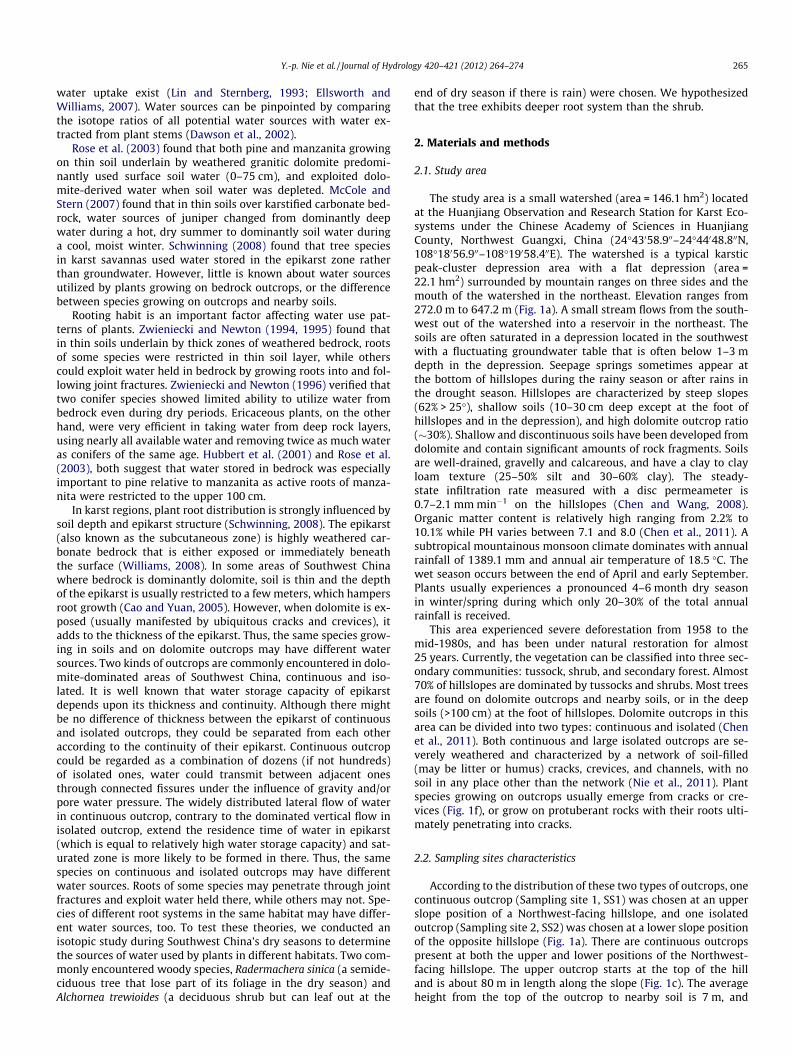
The study area is a small watershed (area = 146.1 hm2) locatedat the Huanjiang Observation and Research Station for Karst Eco-systems under the Chinese Academy of Sciences in HuanjiangCounty, Northwest Guangxi, China (24�43058.900–24�44048.800N,108�18056.900–108�19058.400E). The watershed is a typical karsticpeak-cluster depression area with a flat depression (area =22.1 hm2) surrounded by mountain ranges on three sides and themouth of the watershed in the northeast. Elevation ranges from272.0 m to 647.2 m (Fig. 1a). A small stream flows from the south-west out of the watershed into a reservoir in the northeast. Thesoils are often saturated in a depression located in the southwestwith a fluctuating groundwater table that is often below 1–3 mdepth in the depression. Seepage springs sometimes appear atthe bottom of hillslopes during the rainy season or after rains inthe drought season. Hillslopes are characterized by steep slopes(62% > 25�), shallow soils (10–30 cm deep except at the foot ofhillslopes and in the depression), and high dolomite outcrop ratio(�30%). Shallow and discontinuous soils have been developed fromdolomite and contain significant amounts of rock fragments. Soilsare well-drained, gravelly and calcareous, and have a clay to clayloam texture (25–50% silt and 30–60% clay). The steady-state infiltration rate measured with a disc permeameter is0.7–2.1 mm min�1 on the hillslopes (Chen and Wang, 2008).Organic matter content is relatively high ranging from 2.2% to10.1% while PH varies between 7.1 and 8.0 (Chen et al., 2011). Asubtropical mountainous monsoon climate dominates with annualrainfall of 1389.1 mm and annual air temperature of 18.5 �C. Thewet season occurs between the end of April and early September.Plants usually experiences a pronounced 4–6 month dry seasonin winter/spring during which only 20–30% of the total annualrainfall is received.
This area experienced severe deforestation from 1958 to themid-1980s, and has been under natural restoration for almost25 years. Currently, the vegetation can be classified into three sec-ondary communities: tussock, shrub, and secondary forest. Almost70% of hillslopes are dominated by tussocks and shrubs. Most treesare found on dolomite outcrops and nearby soils, or in the deepsoils (>100 cm) at the foot of hillslopes. Dolomite outcrops in thisarea can be divided into two types: continuous and isolated (Chenet al., 2011). Both continuous and large isolated outcrops are se-verely weathered and characterized by a network of soil-filled(may be litter or humus) cracks, crevices, and channels, with nosoil in any place other than the network (Nie et al., 2011). Plantspecies growing on outcrops usually emerge from cracks or cre-vices (Fig. 1f), or grow on protuberant rocks with their roots ulti-mately penetrating into cracks.
2.2. Sampling sites characteristics
According to the distribution of these two types of outcrops, onecontinuous outcrop (Sampling site 1, SS1) was chosen at an upperslope position of a Northwest-facing hillslope, and one isolatedoutcrop (Sampling site 2, SS2) was chosen at a lower slope positionof the opposite hillslope (Fig. 1a). There are continuous outcropspresent at both the upper and lower positions of the Northwest-facing hillslope. The upper outcrop starts at the top of the hilland is about 80 m in length along the slope (Fig. 1c). The averageheight from the top of the outcrop to nearby soil is 7 m, and

a
b c
d e f g
Fig. 1. Distribution of sampling sites and pictures of different habitats: (a) Distribution of sampling sites within the watershed; (b) Distribution of isolated bedrock outcropson the Southeast-facing hillslope; (c) Distribution of continuous bedrock outcrops along the Northwest-facing hillslope; (d) Plants growing on the isolated bedrock outcrop;(e) Soil profile near the foot of the isolated bedrock outcrop; (f) Plants growing on the continuous bedrock outcrops; and (g) Soil profile near the foot of the continuousbedrock outcrops.
266 Y.-p. Nie et al. / Journal of Hydrology 420–421 (2012) 264–274
average width of the outcrop is 20 m. The outcrop is covered bydense vegetation (Fig. 1f), with R. sinica and Celtis biondii Pampdominating the tree layer. A. trewioides and Loropetalum chinensedominate the shrub layer. Soil at the foot of the outcrop is shallow(about 30 cm deep) and discontinuous, horizontally interrupted bysmall outcrops, and vertically interrupted by big rocks (Fig. 1g).These two distinct habitats both contain R. sinica and A. trewioides.The opposite hillslope is covered by tussocks and shrubs, withmany isolated dolomite outcrops of various sizes along the slope(Fig. 1b). A cube-shaped outcrop at the bottom of the slope witha rough surface of about 100 m2 (about 8 m in length and 12.5 m
in width) and approximately 8 m high was chosen for the study(Fig. 1d). The tree layer is dominated by R. sinica and Sterculianobilis, and the shrub layer is dominated by A. trewioides and Vitex.Negundo Linn. Soils around the outcrop are deep (80–100 cm) andclayey with a layer of highly weathered bedrock about 30 cm thickand crumbly by bare hand below the soil (Fig. 1e). This severelyweathered bedrock is followed by a weakly weathered layer. Theabsence of trees in this habitat may result from humandisturbance.
In addition, three spring outflow points were selected. Spring 1(S1) is located at the bottom of the Northwest-facing hillslope,
Y.-p. Nie et al. / Journal of Hydrology 420–421 (2012) 264–274 267
Spring 2 (S2) is located in the depression near the bottom of theother selected hillslope (Southeast-facing), Spring 3 (S3) is at thelower slope position of a Southeast-facing hillslope about 1 kmaway from S2 (Fig. 1a).
2.3. Water sources in the environment
In karst regions, plants growing on outcrops and surroundingsoils are likely to have deep roots and extract groundwater orwater from the saturated zone, but, in this case, spring water isthe only easily accessible source of deep water (Bonacci, 2001;White, 2002; Bakalowicz, 2005). We assumed that isotopic compo-sitions of deep water sources were relatively stable and could bedistinguished from other sources (e.g., rainwater and soil water)during most of the year. Thus, isotopic composition of spring watercould be used to represent that of deep water sources potentiallyaccessed by plants. Rainwater was treated as a potential watersource for plants growing on outcrops as they can use rainwaterstored in crevices/cracks directly. Dolomite outcrops in the studyarea were severely weathered and manifested by ubiquitous cracksand crevices, with most rainwater flowing along connected fissuresinto deeper layers without time delay and mixing with other kindsof water. However, a small part of rainwater may be stored intightly closed fissures. Rainwater stored in cracks and creviceshad not undergone evaporative enrichment, mixing with otherkinds of water sources (Stothoff et al., 1999), or been influencedby too much evaporation (Querejeta et al., 2006). Since most plantsabsorb water from shallow layers when it is available (Schenk,2005), water stored in upper layer rock fissures should be depletedmore rapidly than that in deeper layers and dominated by recentrainwater. Thus recent (within the last one month) rainwaterwas used to represent water stored in rock fissures of the upperlayers, while previous (one to two months ago) rainwater was usedto represent water in deeper layers of the unsaturated zone. Bothspring water and soil water at different depths throughout the soilprofile were treated as potential water sources for species growingon soils.
2.4. Precipitation and spring water sampling
Monthly rainfall samples were routinely collected from Novem-ber 2008–November 2009, except December 2008, Jan. 2009, andFebruary 2009. The collection equipment was designed accordingto the new device for monthly rainfall sampling for the Global Net-work of Isotopes in Precipitation (IAEA, 2002). Samples for mainrain events between November 1, 2008 and March 23, 2009 (thefirst plant sampling date) and between October 1, 2009 andNovember 8, 2009 (the second plant sampling date) were collectedseparately. Rainwater for single rain events was collected in a plas-tic tank with safeguards to prevent evaporation (Li et al., 2007).Spring water was sampled regularly both in the two dry seasonsand the wet season between November 2008 and November2009. Both rainwater and spring water were stored in cap vials,wrapped in parafilm, and frozen until stable isotope analysis.
2.5. Plant and soil sampling
Plant sampling was conducted separately on March 23, 2009(late dry season of 2008–2009) and November 8, 2009 (early dryseason of 2009–2010). At SS1, the two most frequently encoun-tered species (R. sinica and A. trewioides) both growing on the con-tinuous outcrop (SS1-outcrop) and in nearby thin soils (SS1-soil)were sampled. At SS2, A. trewioides growing on the isolated outcrop(SS2-outcrop) and in nearby soils (SS2-soil) was sampled, while R.sinica was sampled on the outcrop. Suberized twigs were cut fromthe canopy (using high sticks scissors) and leaves and green stem
tissue were removed to avoid contamination of stem water by iso-topically enriched water (Ehleringer and Dawson, 1992; Querejetaet al., 2006). Three adult plants were selected per species per hab-itat. Clipped twigs were immediately placed in a capped vial andwrapped in parafilm. In the laboratory, samples were frozen andstored.
Soil samples were collected with a soil auger. At each samplingtime, three locations were randomly chosen per sampling site. Soilsamples were collected from depths of 0–5, 5–10, 10–20 and20–30 cm at SS1, and from depths of 0–5, 5–10, 10–20, 20–30,30–50, 50–70, 70–90 and 90–100 cm (the severely weathereddolomite layer) at SS2. All soil samples were placed in capped vials,wrapped in parafilm, frozen, and stored.
2.6. Root investigation
According to their distribution, eight R. sinica and fifteen A. tre-wioides plants growing on soils were selected for root investiga-tion. Entire root systems were excavated by manual digging andtheir characteristics were recorded (e.g., root style, maximum ver-tical depth, and maximum root length). Characteristics of R. sinicaroots growing on outcrops were recorded by visual inspectionmade in roadcuts near the study area. Root characteristics of A. tre-wioides growing on outcrops were observed in whole root systemsextracted from cracks. The characters of coarse and fine roots wererecorded and lost roots were estimated from the size and numberof break-points.
2.7. Lab analysis
Stem and soil water were extracted by Ehleringer et al.’s (2000)cryogenic vacuum method. Samples were measured with a Finni-gan MAT Delta V advantage isotope ratio mass spectrometer atthe Stable Isotope Ratio Mass Spectrometer Facility, Chinese Acad-emy of Forestry. Isotopic composition of oxygen is expressed indelta notation (d) as
d ¼ ðRsample=Rstandard � 1Þ � 1000 ð1Þ
where d is the differential isotope value of the sample relative tostandard (SMOW), and R is the absolute isotopic ratio (18O/16O) ofthe sample or standard. Analytical precision was better than 0.2‰.
2.8. Data analysis
The most probable sources of water up-take, was found byusing oxygen isotopic composition to compare stem water withpotential water sources of spring water, rainwater (plants growingon outcrops), or soil water (plants growing on soils) in order toidentify the best ‘match’. This approach was named by Asbjornsenet al. (2007) as ‘‘Direct Inference’’. In this approach, stem water ofeach plant was treated separately and the average d18O values ofspring water (on plant sampling day) of the three outflow pointswere used. Rainwater of the sampled event rainfall before the plantsampling day was treated as a single water source, while monthlyrainwater received just before rain events was treated as a mixture.According to soil sampling increments, soil water of each layer wastreated as a single water source.
As contributions of water from different water sources could ac-count for the same stem water isotope values, actual plant watersources may be misinterpreted based only on the direct inferenceapproach (Asbjornsen et al., 2007). Therefore, d18O values of poten-tial water sources and stem water were analyzed with the Iso-Source model (Phillips and Gregg, 2003) to evaluate relativecontribution of each source to stem water. Spring water and rain-water were treated in the same way as the former approach. Aver-age isotope values/species/habitat were used in the model, instead
268 Y.-p. Nie et al. / Journal of Hydrology 420–421 (2012) 264–274
of treating each plant individually. The number of potential watersources was reduced and the results were simplified by combiningadjacent soil layers into a single layer if they had the similar iso-tope values (Phillips et al., 2005). To guarantee that no legitimatefeasible source combinations was missed, the fractional incrementemployed in our calculations was 0.2, and uncertainty or ‘‘massbalance tolerance’’ was not smaller than half this amount(0.5 � increment �maximum difference between sources) (Phil-lips and Gregg, 2003). Uncertainty level was set at 0.2‰ in ourcalculations.
3. Results
3.1. Precipitation distribution and isotopic compositions of rainwaterand spring water
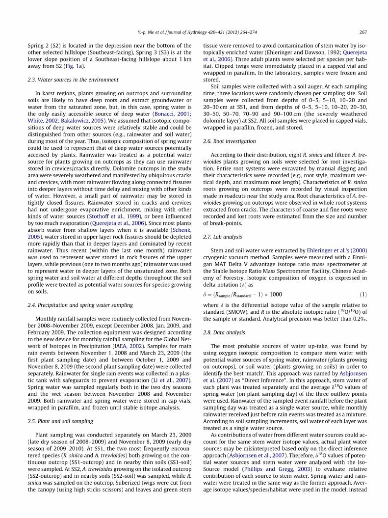
Fig. 2 shows rainfall measured in the study area and d18O valuesof rainwater (both amount-weighted monthly rainfall and eventrainfall) and spring water from November 2008–November 2009.The study area received 139 mm of rainfall in November 2008,2.6 times the long-term mean monthly rainfall amount. 26% oflong-term mean precipitation was received in a wet month fol-lowed by severe drought (December 2008–February 2009). Thecontinuous drought was terminated by rain events (78.8 mm total)in early March 2009. The first plants/soil sampling was conductedin the ten clear days following the last rainfall (received March 13,2009).
Fig. 2. Distribution of daily rainfall and fluctuation of d18O values of amount-weighted mrainfall and spring water. Arrows indicate sampling times. Error bars represent SE.
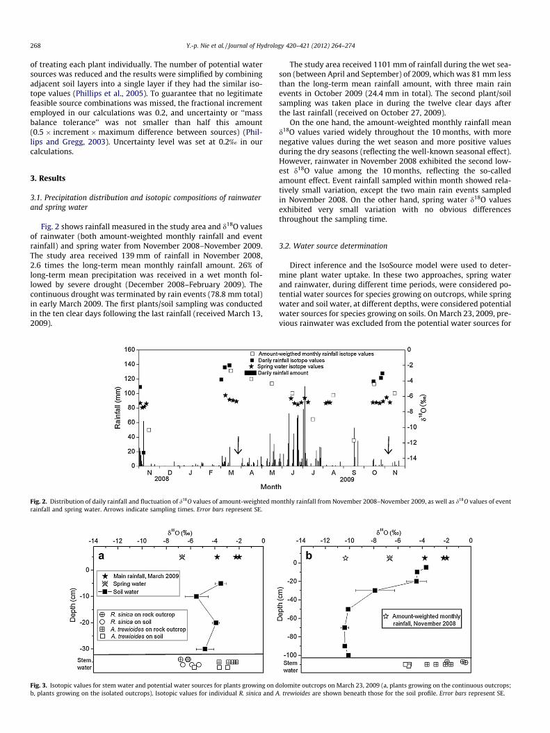
Fig. 3. Isotopic values for stem water and potential water sources for plants growing on db, plants growing on the isolated outcrops). Isotopic values for individual R. sinica and A
The study area received 1101 mm of rainfall during the wet sea-son (between April and September) of 2009, which was 81 mm lessthan the long-term mean rainfall amount, with three main rainevents in October 2009 (24.4 mm in total). The second plant/soilsampling was taken place in during the twelve clear days afterthe last rainfall (received on October 27, 2009).
On the one hand, the amount-weighted monthly rainfall meand18O values varied widely throughout the 10 months, with morenegative values during the wet season and more positive valuesduring the dry seasons (reflecting the well-known seasonal effect).However, rainwater in November 2008 exhibited the second low-est d18O value among the 10 months, reflecting the so-calledamount effect. Event rainfall sampled within month showed rela-tively small variation, except the two main rain events sampledin November 2008. On the other hand, spring water d18O valuesexhibited very small variation with no obvious differencesthroughout the sampling time.
3.2. Water source determination
Direct inference and the IsoSource model were used to deter-mine plant water uptake. In these two approaches, spring waterand rainwater, during different time periods, were considered po-tential water sources for species growing on outcrops, while springwater and soil water, at different depths, were considered potentialwater sources for species growing on soils. On March 23, 2009, pre-vious rainwater was excluded from the potential water sources for
onthly rainfall from November 2008–November 2009, as well as d18O values of event
olomite outcrops on March 23, 2009 (a, plants growing on the continuous outcrops;. trewioides are shown beneath those for the soil profile. Error bars represent SE.
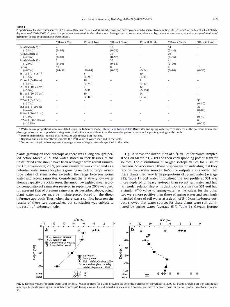
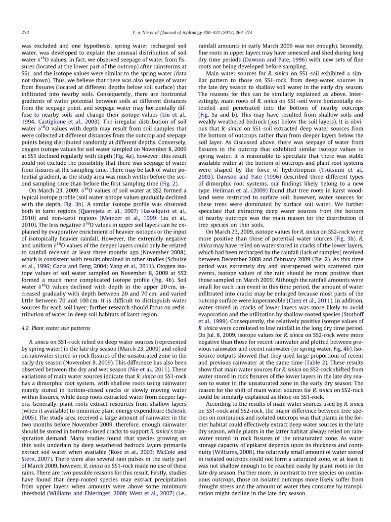
Table 1Proportions of feasible water sources (%)a R. sinica (tree) and A. trewioides (shrub) growing on outcrops and nearby soils at two sampling site (SS1 and SS2) on March 23, 2009 (latedry season of 2008–2009). Oxygen isotope values were used for the calculations. Average source proportions calculated by the model are shown, as well as range of minimum/maximum source proportions (in parentheses).
SS1-rock Tree SS1-soil Tree SS1-rock Shrub SS1-soil Shrub SS2-rock Shrub SS2-soil Shrub
Rain1(March 2) b
(�3.8‰) c4(0–16)
19(0–54)
– 14(0–44)
–
Rain2(March 6)(�2.3‰)
3(0–10)
37(0–92)
– 39(0–96)
–
Rain3(March 13)(�2.0‰)
2(0–10)
36(0–86)
41(0–90)
Spring(�6.7‰)
91(84–98)
61(26–84)
8(0–20)
5(0–24)
6(0–16)
15(0–56)
SS1-soil (0–5 cm) d
(�3.5‰)– 6
(0–28)– 40
(0–86)– –
SS1-soil (5–10 cm)(�5.5‰)
– 16(0–74)
– 9(0–40)
– –
SS1-soil (10–20 cm)(�3.9‰)
– 7(0–32)
– 32(0–100)
– –
SS1-soil (20–30 cm)(�4.8‰)
– 10(0–46)
– 14(0–60)
– –
SS2-soil (0–5 cm)(�3.7‰)
– – – – – 36(0–80)
SS2-soil (5–20 cm)(�4.4‰)
– – – – – 33(0–88)
SS2-soil (20–30 cm)(�7.9‰)
– – – – – 10(0–40)
SS2-soil (30–100 cm)(�10.3‰)
– – – – – 6(0–24)
a Water source proportions were calculated using the IsoSource model (Phillips and Gregg, 2003), Rainwater and spring water were considered as the potential sources forplants growing on outcrop, while spring water and soil water at different depths were the potential sources for plants growing on thin soils.
b Date in parenthesis indicate that rainwater was received on that day.c Negative values in parenthesis indicate the d18O value of water specified in the table.d Soil water isotopic values represent average values of depth intervals specified in the table.
Y.-p. Nie et al. / Journal of Hydrology 420–421 (2012) 264–274 269
plants growing on rock outcrops as there was a long drought per-iod before March 2009 and water stored in rock fissures of theunsaturated zone should have been recharged from recent rainwa-ter. On November 8, 2009, previous rainwater was considered as apotential water source for plants growing on rock outcrops, as iso-tope values of stem water exceeded the range between springwater and recent rainwater. Considering the relatively low waterstorage capacity of rock fissures, the amount-weighted mean isoto-pic composition of rainwater received in September 2009 was usedto represent that of previous rainwater. As described above, actualplant water sources may be misinterpreted based on the directinference approach. Thus, when there was a conflict between theresults of these two approaches, our conclusion was subject tothe result of IsoSource model.
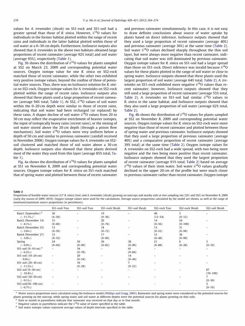
Fig. 4. Isotopic values for stem water and potential water sources for plants growingoutcrops; b, plants growing on the isolated outcrops). Isotopic values for individual R. siniSE.
Fig. 3a shows the distribution of d18O values for plants sampledat SS1 on March 23, 2009 and their corresponding potential watersources. The distributions of oxygen isotope values for R. sinica(tree) on SS1-rock match those of spring water, indicating that theyrely on deep water sources. IsoSource outputs also showed thatthese plants used very large proportions of spring water (average91%, Table 1). Soil water throughout the soil profile at SS1 wasmore depleted of heavy isotopes than recent rainwater and hadno regular relationship with depth. One R. sinica on SS1-soil hada similar d18O value to spring water, while values for the othertwo were more positive than those of spring water and seeminglymatched those of soil water at a depth of 5–10 cm. IsoSource out-puts showed that water sources for these plants were still domi-nated by spring water (average 61%, Table 1). Oxygen isotope
on dolomite outcrops on November 8, 2009 (a, plants growing on the continuousca and A. trewioides are shown beneath those for the soil profile. Error bars represent
270 Y.-p. Nie et al. / Journal of Hydrology 420–421 (2012) 264–274
values for A. trewioides (shrub) on SS1-rock and SS1-soil had agreater spread than those of R. sinica. However, d18O values forindividuals in the former habitat plotted within the range of recentrains and individuals in the latter habitat plotted within those ofsoil water at a 0–30 cm depth. Furthermore, IsoSource outputs alsoshowed that A. trewioides in the above two habitats obtained largeproportions of recent rainwater (average 92% total) and soil water(average 95%), respectively (Table 1).
Fig. 3b shows the distribution of d18O values for plants sampledat SS2 on March 23, 2009 and corresponding potential watersources. Oxygen isotope value for one R. sinica on SS2-rockmatched those of recent rainwater, while the other two exhibitedvery positive isotope values, beyond the confine of those of poten-tial water sources. Thus, there was no IsoSource solution for R. sini-ca on SS2-rock. Oxygen isotope values for A. trewioides on SS2-rockplotted within the range of recent rains. IsoSource outputs alsoshowed that these plants used a large proportion of recent rainwa-ter (average 94% total, Table 1). At SS2, d18O values of soil waterwithin the 0–20 cm depth were similar to those of recent rains,indicating that soil water had been recharged (or replaced) bythese rains. A shaper decline of soil water d18O values from 20 to50 cm may reflect the evaporative enrichment of heavier isotopes,the input of isotopically heavy rains (recent rains), or the mixing ofsoil water stored above the 20 cm depth (through a piston flowmechanism). Soil water d18O values were very uniform below adepth of 50 cm and similar to previous rainwater (rainfall receivedin November 2008). Oxygen isotope values for A. trewioides on SS2-soil clustered and matched those of soil water above a 30 cmdepth. IsoSource outputs also showed that these plants derivedmost of the water they used from this layer (average 85% total, Ta-ble 1).
Fig. 4a shows the distribution of d18O values for plants sampledat SS1 on November 8, 2009 and corresponding potential watersources. Oxygen isotope values for R. sinica on SS1-rock matchedthat of spring water and plotted between those of recent rainwater
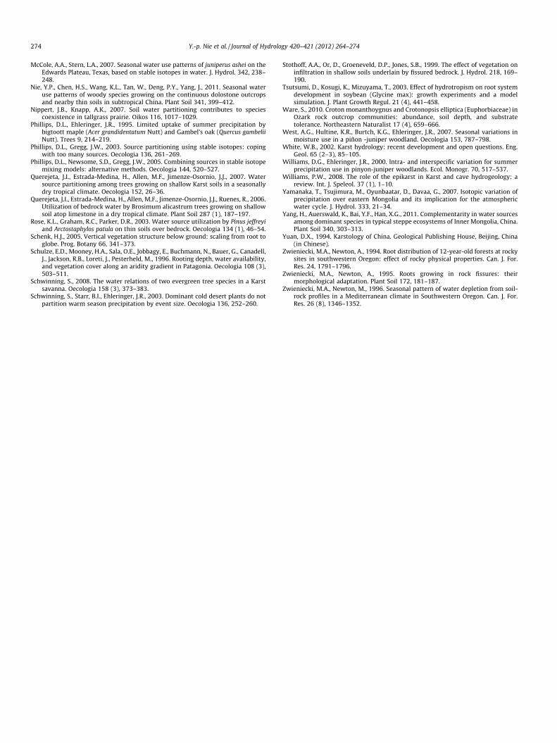
Table 2Proportions of feasible water sources (%)a R. sinica (tree) and A. trewioides (shrub) growing(early dry season of 2009–2010). Oxygen isotope values were used for the calculations. Avminimum/maximum source proportions (in parentheses).
SS1-rock Tree SS1-soil Tree SS1-rock Shrub
Rain1 (September) b
(�11.7‰) c36(6–50)
– 19(0–36)
Rain2 (November 14)(�4.1‰)
15(0–60)
– 20(0–76)
Rain3 (November 25)(�3.6‰)
13(0–56)
– 18(0–72)
Rain4 (November 27)(�3.0‰)
12(0–52)
– 17(0–66)
Spring(�6.9‰)
24(0–94)
36(0–90)
26(0–82)
SS1-soil (0–10 cm) d
(�6.2‰)– 34
(0–78)–
SS1-soil (10–20 cm)�9.0‰)
– 20(0–54)
–
SS1-soil (20–30 cm)(�11.2‰)
– 10(0–28)
–
SS2-soil (0–30 cm)(�10.4‰)
– – –
SS2-soil (30–50 cm)(�9.1‰)
– – –
SS2-soil(50–100 cm)(�6.7‰)
– – –
a Water source proportions were calculated using the IsoSource model (Phillips and Grplants growing on the outcrop, while spring water and soil water at different depths w
b Date or month in parenthesis indicate that rainwater was received on that day or inc Negative values in parenthesis indicate the d18O value of water specified in the tabld Soil water isotopic values represent average values of depth intervals specified in th
and previous rainwater simultaneously. In this case, it is not easyto draw definite conclusions about source of water uptake byplants based on direct inference. IsoSource outputs showed thatthey used a large proportion of recent rainwater (average 40%)and previous rainwater (average 36%) at the same time (Table 2).Soil water d18O values declined sharply throughout the thin soillayer, but were always more negative than recent rainwater, indi-cating that soil water was still dominated by previous rainwater.Oxygen isotope values for R. sinica on SS1-soil had a larger spreadthan those on SS1-rock. Direct inference was invalid because d18Ovalues for these plants plotted in the range of soil water or close tospring water. IsoSource outputs showed that these plants used thelargest proportion of soil water (average 64% total, Table 2). A. tre-wioides on SS1-rock exhibited more negative d18O values than re-cent rainwater; however, IsoSource outputs showed that theystill used a large proportion of recent rainwater (average 55% total,Table 2). A. trewioides on SS1-soil had similar d18O values toR. sinica in the same habitat, and IsoSource outputs showed thatthey also used a large proportion of soil water (average 62% total,Table 2).
Fig. 4b shows the distribution of d18O values for plants sampledat SS2 on November 8, 2009 and corresponding potential watersources. Oxygen isotope values for R. sinica on SS2-rock were morenegative than those of recent rainwater and plotted between thoseof spring water and previous rainwater. IsoSource outputs showedthat they used a large proportion of previous rainwater (average40%) and a comparative proportion of recent rainwater (average39% total) at the same time (Table 2). Oxygen isotope values forA. trewioides on SS2-rock had a wide spread, with two being morenegative and the two being more positive than recent rainwater.IsoSource outputs showed that they used the largest proportionof recent rainwater (average 91% total, Table 2) based on averaged18O values of their stem water. Soil water d18O values graduallydeclined in the upper 20 cm of the profile but were much closerto previous rainwater rather than recent rainwater. Oxygen isotope
on outcrops and nearby soils at two sampling site (SS1 and SS2) on November 8, 2009erage source proportions calculated by the model are shown, as well as the range of
SS1-soil Shrub SS2-rock Tree SS2-rock Shrub SS2-soil Shrub
– 40(12–54)
3(0–12)
–
– 14(0–56)
24(0–100)
–
– 13(0–52)
31(0–98)
–
– 12(0–48)
36(0–90)
–
38(0–96)
21(0–88)
6(0–28)
3(0–10)
41(0–84)
– – –
14(0–44)
– – –
7(0–22)
– – –
– – – 87(70–100)
– – – 7(0–30)
– – – 3(0–10)
egg, 2003), Rainwater and spring water were considered as the potential sources forere the potential sources for plants growing on thin soils.
that month.e.e table.

Y.-p. Nie et al. / Journal of Hydrology 420–421 (2012) 264–274 271
values increased from �10.83‰ at 20 cm depth to �6.51‰ at70 cm depth and exhibited similar isotope values to spring waterbelow 70 cm depth. Oxygen isotope values for A. trewioides onSS2-soil clustered and matched those of soil water above 30 cmdepth. IsoSource outputs also showed that these plants derived al-most all the water they used from this layer (average 87%, Table 2).
3.3. Root distribution
A. trewioides growing in soils exhibited a typical shallow rootsystem. Although height of excavated individuals varied from130 cm to 300 cm, most of their roots were restricted within theupper 30 cm. Main roots were horizontally oriented, with the lon-gest observed root being 140 cm away from the base of the trunk.In addition, all coarse roots were surrounded by a high density offine roots (<1 or 2 mm in diameter). Roots of R. sinica growing onsoils (deep soil habitat was excluded from the investigation) werealso concentrated in upper soil layers, with only a few relativelysmall roots (<30 mm in diameter) penetrating vertically into lowerlayers (Fig. 5). Although these horizontally oriented roots spreadfar from the base of trunks (some spread further than 5 m), mostof them were limited within 1 m vertically. In addition, most ofthese roots finally penetrated into the bottoms of nearby dolomiteoutcrops. Contrary to the high density of fine roots for A. trewioides,R. sinica had a relatively low density of fine roots in the soil layers.
A. trewioides growing on outcrops also exhibited shallow rootsystems. The whole coarse root system (more than 2 mm in diam-eter) of a large proportion of plants could be pulled out manuallywithout tools. Root broken-points were occasionally encounteredbecause of this rude investigation method; however, most of themwere in small sizes and had no effect on judging the style of theroot system. In addition, A. trewioides growing on outcrops had ahigh density of fine roots. Roots of tree species, such as R. sinica,growing on outcrops could penetrate through soil-filled cracksand crevices into deep layers (Stothoff et al., 1999); however, wehad no robust information to support this result.
Fig. 5. Horizontal distribution of main roots for R. sinica growing on thin soils (a, main rooroots for R. sinica growing on thin soils underlain by consolidated bedrock; c, main root
4. Discussion
4.1. Potential water sources
4.1.1. Rainwater and spring waterThe amount-weighted monthly rainfall mean d18O values varied
widely from November 2008–November 2009 and reflected a well-known seasonal effect, while event rainfall sampled within monthshowed relatively small variation (Fig. 2). Similar results have alsobeen obtained in many other regions around the world (Ingrahamet al., 1991; Jones and Ingraham et al., 2004; Yamanaka et al.,2007). Generally, plants take up water derived from rainwaterfrom different kinds of water-bearing media, however, speciesgrowing on rock outcrops may use rainwater stored in bottom-closed cracks/fissures or intercept slow moving rainwater withinfissures. Thus, rainwater of different time periods were consideredas potential water sources for plants growing on rock outcrops inthis study. In fact, many previous studies took rainwater as a po-tential water source for plants in different habitats (Phillips andEhleringer, 1995; Williams and Ehleringer, 2000; Schwinning,2008).
Oxygen isotope values of spring water exhibited relatively stea-dy d18O values throughout the sample period (Fig. 2). The smallvariation of d18O values of spring water have been discussed inour previous paper (Nie et al., 2011). Isotopic compositions ofspring water, first used by McCole and Stern (2007) in determiningwater sources of plant in karst region, was used to represent thoseof deep water sources that are potentially accessed by plant.
4.1.2. Soil waterOn March 23, 2009, oxygen isotope values for soil water sam-
pled at SS1 plotted between those of recent rainwater and springwater and had no regular relationship with depth (Fig. 3a). Theo-retically, d18O values for soil water should be more positive thanthose of recent rainwater, or at least within the range of those ofrecent rainwater (Nie et al., 2011). The possibility of hydraulic lift
ts for R. sinica growing on thin soil underlain by weakly weathered bedrock; b, mains for R. sinica growing on loose rocky soil).
272 Y.-p. Nie et al. / Journal of Hydrology 420–421 (2012) 264–274
was excluded and one hypothesis, spring water recharged soilwater, was developed to explain the unusual distribution of soilwater d18O values. In fact, we observed seepage of water from fis-sures (located at the lower part of the outcrop) after rainstorms atSS1, and the isotope values were similar to the spring water (datanot shown). Thus, we believe that there was also seepage of waterfrom fissures (located at different depths below soil surface) thatinfiltrated into nearby soils. Consequently, there are horizontalgradients of water potential between soils at different distancesfrom the seepage point, and seepage water may horizontally dif-fuse to nearby soils and change their isotope values (Liu et al.,1994; Castiglione et al., 2003). The irregular distribution of soilwater d18O values with depth may result from soil samples thatwere collected at different distances from the outcrop and seepagepoints being distributed randomly at different depths. Conversely,oxygen isotope values for soil water sampled on November 8, 2009at SS1 declined regularly with depth (Fig. 4a), however; this resultcould not exclude the possibility that there was seepage of waterfrom fissures at the sampling time. There may be lack of water po-tential gradient, as the study area was much wetter before the sec-ond sampling time than before the first sampling time (Fig. 2).
On March 23, 2009, d18O values of soil water at SS2 formed atypical isotope profile (soil water isotope values gradually declinedwith the depth, Fig. 3b). A similar isotope profile was observedboth in karst regions (Querejeta et al., 2007; Hasselquist et al.,2010) and non-karst regions (Meinzer et al., 1999; Liu et al.,2010). The less negative d18O values in upper soil layers can be ex-plained by evaporative enrichment of heavier isotopes or the inputof isotopically heavier rainfall. However, the extremely negativeand uniform d18O values of the deeper layers could only be relatedto rainfall received at least three months ago (November 2008),which is consistent with results obtained in other studies (Schulzeet al., 1996; Gazis and Feng, 2004; Yang et al., 2011). Oxygen iso-tope values of soil water sampled on November 8, 2009 at SS2formed a much more complicated isotope profile (Fig. 4b). Soilwater d18O values declined with depth in the upper 20 cm, in-creased gradually with depth between 20 and 70 cm, and variedlittle between 70 and 100 cm. It is difficult to distinguish watersources for each soil layer; further research should focus on redis-tribution of water in deep soil habitats of karst region.
4.2. Plant water use patterns
R. sinica on SS1-rock relied on deep water sources (representedby spring water) in the late dry season (March 23, 2009) and reliedon rainwater stored in rock fissures of the unsaturated zone in theearly dry season (November 8, 2009). This difference has also beenobserved between the dry and wet season (Nie et al., 2011). Thesevariations of main water sources indicate that R. sinica on SS1-rockhas a dimorphic root system, with shallow roots using rainwatermainly stored in bottom-closed cracks or slowly moving waterwithin fissures, while deep roots extracted water from deeper lay-ers. Generally, plant roots extract resources from shallow layers(when it available) to minimize plant energy expenditure (Schenk,2005). The study area received a large amount of rainwater in thetwo months before November 2009, therefore, enough rainwatershould be stored in bottom-closed cracks to support R. sinica’s tran-spiration demand. Many studies found that species growing onthin soils underlain by deep weathered bedrock layers primarilyextract soil water when available (Rose et al., 2003; McCole andStern, 2007). There were also several rain pulses in the early partof March 2009, however, R. sinica on SS1-rock made no use of theserains. There are two possible reasons for this result. Firstly, studieshave found that deep-rooted species may extract precipitationfrom upper layers when amounts were above some minimumthreshold (Williams and Ehleringer, 2000; West et al., 2007) (i.e.,
rainfall amounts in early March 2009 was not enough). Secondly,fine roots in upper layers may have senesced and shed during longdry time periods (Dawson and Pate, 1996) with new sets of fineroots not being developed before sampling.
Main water sources for R. sinica on SS1-soil exhibited a sim-ilar pattern to those on SS1-rock, from deep-water sources inthe late dry season to shallow soil water in the early dry season.The reasons for this can be similarly explained as above. Inter-estingly, main roots of R. sinica on SS1-soil were horizontally ex-tended and penetrated into the bottom of nearby outcrops(Fig. 5a and b). This may have resulted from shallow soils andweakly weathered bedrock (just below the soil layers). It is obvi-ous that R. sinica on SS1-soil extracted deep water sources fromthe bottom of outcrops rather than from deeper layers below thesoil layer. As discussed above, there was seepage of water fromfissures in the outcrop that exhibited similar isotope values tospring water. It is reasonable to speculate that there was stableavailable water at the bottom of outcrops and plant root systemswere shaped by the force of hydrotropism (Tsutsumi et al.,2003). Dawson and Pate (1996) described three different typesof dimorphic root systems, our findings likely belong to a newtype. Heilman et al. (2009) found that tree roots in karst wood-land were restricted to surface soil; however, water sources forthese trees were dominated by surface soil water. We furtherspeculate that extracting deep water sources from the bottomof nearby outcrops was the main reason for the distribution oftree species on thin soils.
On March 23, 2009, isotope values for R. sinica on SS2-rock weremore positive than those of potential water sources (Fig. 3b). R.sinica may have relied on water stored in cracks of the lower layers,which had been recharged by the rainfall (lack of samples) receivedbetween December 2008 and February 2009 (Fig. 2). As this timeperiod was extremely dry and interspersed with scattered rainevents, isotope values of the rain should be more positive thanthose sampled on March 2009. Although the rainfall amounts weresmall for each rain event in this time period, the amount of waterinfiltrated into cracks may be enlarged because most parts of theoutcrop surface were impermeable (Chen et al., 2011). In addition,water stored in cracks of lower layers was more likely to avoidevaporation and the utilization by shallow-rooted species (Stothoffet al., 1999). Consequently, the relatively positive isotope values ofR. sinica were correlated to low rainfall in the long dry time period.On Jul. 8, 2009, isotope values for R. sinica on SS2-rock were morenegative than those for recent rainwater and plotted between pre-vious rainwater and recent rainwater (or spring water, Fig. 4b). Iso-Source outputs showed that they used large proportions of recentand previous rainwater at the same time (Table 2). These resultsshow that main water sources for R. sinica on SS2-rock shifted fromwater stored in rock fissures of the lower layers in the late dry sea-son to water in the unsaturated zone in the early dry season. Thereason for the shift of main water sources for R. sinica on SS2-rockcould be similarly explained as those on SS1-rock.
According to the results of main water sources used by R. sinicaon SS1-rock and SS2-rock, the major difference between tree spe-cies on continuous and isolated outcrops was that plants in the for-mer habitat could effectively extract deep water sources in the latedry season, while plants in the latter habitat always relied on rain-water stored in rock fissures of the unsaturated zone. As waterstorage capacity of epikarst depends upon its thickness and conti-nuity (Williams, 2008), the relatively small amount of water storedin isolated outcrops could not form a saturated zone, or at least itwas not shallow enough to be reached easily by plant roots in thelate dry season. Further more, in contrast to tree species on contin-uous outcrops, those on isolated outcrops more likely suffer fromdrought stress and the amount of water they consume by transpi-ration might decline in the late dry season.

Y.-p. Nie et al. / Journal of Hydrology 420–421 (2012) 264–274 273
Contrary to the shifts of water sources used by R. sinica on rockoutcrops and soils (at SS1), main water sources for A. trewioides onSS1-rock and SS2-rock was always dominated by water stored inrock fissures of upper layers, while the same plant on SS1-soiland SS2-soil always relied on shallow soil water. The constant uti-lization of shallow water sources by A. trewioides has a close rela-tionship with its shallow root system. The advantages of shallowroot system and the strategies for plants to adapt shallow root sys-tem have been discussed in our previous paper (Nie et al., 2011). Itis obvious that there was competition between A. trewioides and R.sinica for shallow water sources in the early dry season, while thecompetition intensity decreased significantly when R. sinicaswitched to deeper water sources in the late dry season. Watersource partitioning among species in the same habitat has been ob-served both in karst regions (Hubbert et al., 2001; Querejeta et al.,2007) and non-karst regions (Meinzer et al., 1999; Nippert andKnapp, 2007). Reduced competition between A. trewioides and R.sinica in the late dry season was one of the key factors for theircoexistence in the same habitats.
5. Conclusions
In this study, we mainly used stable isotope techniques todetermine water sources used by woody plants growing on dolo-mite outcrops (both continuous and isolated outcrops) and nearbysoils in dry seasons. R. sinica (semideciduous tree) growing on con-tinuous outcrops and nearby thin soils relied on deep watersources (ground water or water in the saturated zone, representedby spring water) in the late dry season. While it relied on rainwaterstored in the unsaturated zone (for those growing on outcrop) orshallow soil water (for those growing on soils) in the early dry sea-son. Remarkably, R. sinica growing on thin soils extracted deepwater sources from the bottom of nearby outcrops rather thanfrom deeper layers below the soil surface, as most of its main rootswere horizontally extended and penetrated into the bottom ofnearby outcrops. However, R. sinica growing on the isolated out-crop used no deep-water sources even during the late dry season.It relied on rainwater stored in rock fissures of the lower layers inthe late dry season and used recent and previous rainwater simul-taneously in the early dry season. In contrast, A. trewioides (decid-uous shrub) growing on dolomite outcrops and nearby soils alwaysrelied on shallow water sources, which was a result of its shallowroot system. Water source partitioning between tree and shrubspecies in the late dry season was one of the key factors for theircoexistence in the same habitats. Results indicate that plant estab-lishment could not be restricted by existence of rock outcropswhen they are weathered to networks of cracks/fissures. Further-more, the tree species (especially individuals growing on continu-ous outcrops) were more likely to extract deep water sources in thelate dry season, which in turn led to normal transpiration in thelate dry season. On the other hand, the utilization of deep watersources enhanced the water storage capacity of the study area. Fur-ther study is needed to measure the amount of plant transpirationby tree species, especially in the dry season, to assess their ecohy-drological significance.
Acknowledgements
This project was supported by the Chinese Academy of SciencesAction Plan for the Development of Western China (KZCX2-XB3-10), the Knowledge Innovative Program of the Chinese Academyof Sciences (KZCX2-YW-QN404) and the National Natural ScienceFoundation of China (41171187 and 31100294). The authors aregrateful to the anonymous reviewers for their helpful commentsand suggestions to improve this manuscript.
References
Anderson, R.C., Fralish, J.S., Baskin, J.M., 1999. Savannas, Barrens, and Rock OutcropPlant Communities of North America. Cambridge University Press, Cambridge,UK.
Asbjornsen, H., Goldsmith, G.R., Alvarado-Barrientos, M.S., Rebel, K., Van Osch, F.P.,Rietkerk, M., Chen, J.Q., Gotsch, S., Tobòn, C., Geissert, D.R., Gòmez-Tagle, A.,Vache, K., Dawson, T.E., 2011. Ecohydrological advances and applications inplant-water relations research: a review. Journal of Plant Ecology 4 (1–2), 3–22.
Asbjornsen, H., Mora, G., Helmers, M.J., 2007. Variation in water uptake dynamicsamong contrasting agricultural and native plant communities in theMidwestern US. Agric. Ecosyst. Environ. 121, 343–356.
Bakalowicz, M., 2005. Karst groundwater: a challenge for new resources. Hydrol. J.13 (1), 148–160.
Bonacci, O., 2001. Analysis of the maximum discharge of karst springs. Hydrol. J. 9(4), 328–338.
Brunel, J.P., Walker, G.R., Kennett-Smith, A.K., 1995. Field validation of isotopicprocedures for determining sources of water used by plants in a semi-aridenvironment. J. Hydrol. 167 (1–4), 351–368.
Burgman, M.A., 1987. An analysis of the distribution of plants on granite outcrops insouthern Western Australia using Mantel tests. Plant Ecol. 71, 79–86.
Butscher, C., Huggenberger, P., 2009. Modeling the temporal variability of karstgroundwater vulnerability, with implications for climate change. Environ. Sci.Technol. 43 (6), 1665–1669.
Cao, J.H., Yuan, D.X., 2005. Karst Ecosystem of Southwest China Constrained byGeological Setting. Geological Press, Beijing (in Chinese).
Castiglione, P., Mohanty, B.P., Shouse, P.J., Simunek, J., van Genuchten, M.Th.,Santini, A., 2003. Lateral water diffusion in an artificial macroporous system:modeling and experimental evidence. Vadose Zone Journal 2, 212–221.
Chen, H.S., Liu, J.W., Wang, K.L., Zhang, W., 2011. Spatial distribution of rockfragments on steep hillslopes in karst region of northwest Guangxi, China.Catena 84, 21–28.
Chen, H.S., Wang, K.L., 2008. Soil water research in karst mountain areas ofsouthwest China. Research of Agricultural Modernization 29, 734–738 (inChinese).
Crow, S.E., Ware, S., 2007. Soil type tolerance in rock outcrop plants: species of non-calcareous. Southwestern Naturalist 52 (1), 120–125.
Dawson, T.E., Mambelli, S., Plamboeck, A.H., Templer, P.H., Tu, K.P., 2002. Stableisotopes in plant ecology. Ann. Rev. Ecol. Syst. 33 (1), 507–559.
Dawson, T.E., Pate, J.S., 1996. Seasonal water uptake and movement in root systemsof Australian phraeatophytic plants of dimorphic root morphology: a stableisotope investigation. Oecologia 107, 13–20.
Ehleringer, J.R., Dawson, T.E., 1992. Water uptake by plants: perspectives fromstable isotope composition. Plant. Cell. Environ. 15, 1073–1082.
Ehleringer, J.R., Roden, J., Dawson, T.E., 2000. Assessing ecosystem-level waterrelations through stable isotope ratio analyses. In: Sala, O.E., Jackson, R.B.,Mooney, H.A., Howarth, R.W. (Eds.), Methodsin Ecosystem Science. Springer,New York, pp. 181–214.
Ellsworth, P.Z., Williams, D.G., 2007. Hydrogen isotope fractionation during wateruptake by woody xerophytes. Plant Soil 291, 93–107.
Gazis, C., Feng, X.H., 2004. A stable isotope study of soil water: evidence for mixingand preferential flow paths. Geoderma 119 (1–2), 97–111.
Hasselquist, N.J., Allen, M.F., Santiago, L.S., 2010. Water relations of evergreen anddrought-deciduous trees along a seasonally dry tropical forest chronosequence.Oecologia 164, 881–890.
Heilman, J.L., Mcinnes, K.J., Kjelgaard, J.F., Keith Owens, M., Schwinning, S., 2009.Energy balance and water use in a subtropical karst woodland on the EdwardsPlateau, Texas. J. Hydrol. 373, 426–435.
Hubbert, K.R., Beyers, J.L., Graham, R.C., 2001. Roles of weathered bedrock and soilin seasonal water relations of Pinus Jeffreyi and Arctostaphylos patula. Can. J.For. Res. 31 (11), 1947–1957.
EA, I.A., 2002. Special issue on the global network of isotopes in precipitation. WaterEnviron Newslett 16, 5.
Ingraham, N.L., Lyles, B.F., Jacobson, R.L., Hess, J.W., 1991. Stable isotopic study ofprecipitation and spring discharge in southern Nevada. J. Hydrol. 125 (3–4),243–258.
Johnson, K.R., Ingram, B.L., 2004. Spatial and temporal variability in the stableisotope systematics of modern precipitation in China: implications forpaleoclimate reconstructions. Earth Planet. Sci. Lett. 220 (3–4), 365–377.
Li, S.G., Romero-Saltos, H., Tsujimura, M., Sugimoto, A., Sasaki, L., Davaa, G.,Oyunbaatar, D., 2007. Plant water sources in the cold semiarid ecosystem of theupper Kherlen River catchment in Mongolia: A stable isotope approach. J.Hydrol. 333 (1), 109–117.
Lin, G.H., Sternber, L.S.L., 1993. Hydrogen isotopic fractionation by plant rootsduring water uptake in coastal wetland plants. In stable isotopes and plantcarbon/water relations. Academic Press, New York, pp 497–510.
Liu, W.J., Liu, W.Y., Li, P.J., Duan, W.P., Li, H.M., 2010. Dry season water uptake bytwo dominant canopy tree species in a tropical seasonal rainforest ofXishuangbanna, SW China. Agric. For. Meteorol. 150, 380–388.
Liu, Y.P., Steenhuis, T.S., Parlange, J.-Y., 1994. Formation and persistence of fingeredflow fields in coarse grained soils under different moisture contents. J. Hydrol.159, 187–195.
Meinzer, F.C., Andrade, J.L., Goldstein, G., Holbrook, N.M., Cacelier, J., Wright, S.J.,1999. Partitioning of soil water among canopy trees in a seasonally dry tropicalforest. Oecologia 121 (3), 293–301.
274 Y.-p. Nie et al. / Journal of Hydrology 420–421 (2012) 264–274
McCole, A.A., Stern, L.A., 2007. Seasonal water use patterns of juniperus ashei on theEdwards Plateau, Texas, based on stable isotopes in water. J. Hydrol. 342, 238–248.
Nie, Y.P., Chen, H.S., Wang, K.L., Tan, W., Deng, P.Y., Yang, J., 2011. Seasonal wateruse patterns of woody species growing on the continuous dolostone outcropsand nearby thin soils in subtropical China. Plant Soil 341, 399–412.
Nippert, J.B., Knapp, A.K., 2007. Soil water partitioning contributes to speciescoexistence in tallgrass prairie. Oikos 116, 1017–1029.
Phillips, D.L., Ehleringer, J.R., 1995. Limited uptake of summer precipitation bybigtoott maple (Acer grandidentatum Nutt) and Gambel’s oak (Quercus gambeliiNutt). Trees 9, 214–219.
Phillips, D.L., Gregg, J.W., 2003. Source partitioning using stable isotopes: copingwith too many sources. Oecologia 136, 261–269.
Phillips, D.L., Newsome, S.D., Gregg, J.W., 2005. Combining sources in stable isotopemixing models: alternative methods. Oecologia 144, 520–527.
Querejeta, J.I., Estrada-Medina, H., Allen, M.F., Jimenze-Osornio, J.J., 2007. Watersource partitioning among trees growing on shallow Karst soils in a seasonallydry tropical climate. Oecologia 152, 26–36.
Querejeta, J.I., Estrada-Medina, H., Allen, M.F., Jimenze-Osornio, J.J., Ruenes, R., 2006.Utilization of bedrock water by Brosimum alicastrum trees growing on shallowsoil atop limestone in a dry tropical climate. Plant Soil 287 (1), 187–197.
Rose, K.L., Graham, R.C., Parker, D.R., 2003. Water source utilization by Pinus jeffreyiand Arctostaphylos patula on thin soils over bedrock. Oecologia 134 (1), 46–54.
Schenk, H.J., 2005. Vertical vegetation structure below ground: scaling from root toglobe. Prog. Botany 66, 341–373.
Schulze, E.D., Mooney, H.A., Sala, O.E., Jobbagy, E., Buchmann, N., Bauer, G., Canadell,J., Jackson, R.B., Loreti, J., Pesterheld, M., 1996. Rooting depth, water availability,and vegetation cover along an aridity gradient in Patagonia. Oecologia 108 (3),503–511.
Schwinning, S., 2008. The water relations of two evergreen tree species in a Karstsavanna. Oecologia 158 (3), 373–383.
Schwinning, S., Starr, B.I., Ehleringer, J.R., 2003. Dominant cold desert plants do notpartition warm season precipitation by event size. Oecologia 136, 252–260.
Stothoff, A.A., Or, D., Groeneveld, D.P., Jones, S.B., 1999. The effect of vegetation oninfiltration in shallow soils underlain by fissured bedrock. J. Hydrol. 218, 169–190.
Tsutsumi, D., Kosugi, K., Mizuyama, T., 2003. Effect of hydrotropism on root systemdevelopment in soybean (Glycine max): growth experiments and a modelsimulation. J. Plant Growth Regul. 21 (4), 441–458.
Ware, S., 2010. Croton monanthoygnus and Crotonopsis elliptica (Euphorbiaceae) inOzark rock outcrop communities: abundance, soil depth, and substratetolerance. Northeastern Naturalist 17 (4), 659–666.
West, A.G., Hultine, K.R., Burtch, K.G., Ehleringer, J.R., 2007. Seasonal variations inmoisture use in a piñon -juniper woodland. Oecologia 153, 787–798.
White, W.B., 2002. Karst hydrology: recent development and open questions. Eng.Geol. 65 (2–3), 85–105.
Williams, D.G., Ehleringer, J.R., 2000. Intra- and interspecific variation for summerprecipitation use in pinyon-juniper woodlands. Ecol. Monogr. 70, 517–537.
Williams, P.W., 2008. The role of the epikarst in Karst and cave hydrogeology: areview. Int. J. Speleol. 37 (1), 1–10.
Yamanaka, T., Tsujimura, M., Oyunbaatar, D., Davaa, G., 2007. Isotopic variation ofprecipitation over eastern Mongolia and its implication for the atmosphericwater cycle. J. Hydrol. 333, 21–34.
Yang, H., Auerswald, K., Bai, Y.F., Han, X.G., 2011. Complementarity in water sourcesamong dominant species in typical steppe ecosystems of Inner Mongolia, China.Plant Soil 340, 303–313.
Yuan, D.X., 1994. Karstology of China. Geological Publishing House, Beijing, China(in Chinese).
Zwieniecki, M.A., Newton, A., 1994. Root distribution of 12-year-old forests at rockysites in southwestern Oregon: effect of rocky physical properties. Can. J. For.Res. 24, 1791–1796.
Zwieniecki, M.A., Newton, A., 1995. Roots growing in rock fissures: theirmorphological adaptation. Plant Soil 172, 181–187.
Zwieniecki, M.A., Newton, M., 1996. Seasonal pattern of water depletion from soil-rock profiles in a Mediterranean climate in Southwestern Oregon. Can. J. For.Res. 26 (8), 1346–1352.


![DOLOMITE - CatalogoSummer 2011 - [EN]](https://img.dokumen.tips/doc/110x75/568bd6621a28ab20349be1fa/dolomite-catalogosummer-2011-en.jpg)

