Embed Size (px)
Citation preview

1
WATER SAFETY PLAN
WATER SUPPLY SYSTEM DESCRIPTION
COOK ISLANDS
Davendra Nath, Project Officer, SOPAC, Suva, FIJI Mitesh Mudaliar, Project Assistant, WHO, Suva, Fiji. Ben Parakoti, Director, Dept of Water Works, Ministry of Works, Cook Islands
Water Safety Plans Programme -A project Funded by AusAID- August, 2006
2
Table of Contents Page 1 Introduction ……………………………………………………………. 3 1.1 Background …………………………………………………….. 4 1.2 Climate and Geology…………………………………………… 4. 1.3 Groundwater Resources …………………………………….. .. 4 2 Water Supply System Assessment……………………………….. .. 6 2.1 Avana Supply………………………………………………….. 6 2.1.1 Catchment and Intake……………………………………….. 6 2.1.2 Storage and Treatment……………………………………… 7 2.1.3 Distribution……………………………………………………. 8 2.2 Tukavaine Supply……………………………………………...… 9 2.2.1 Background…………………………………………………….. 9 2.2.2 Catchment and Intake………………………………………….. 10 2.2.3 Storage and Treatment………………………………………… 10 2.2.4 Distribution………………………………………………………..11
2.3 Tupapa Water Supply………………………………………….. 12 2.3.1 Catchment and Intake………………………………………….. 12
2.3.2 Storage and Treatment…………………………………………..13 2.3.3 Distribution………………………………………………………...13 3. Water Resource Monitoring…………………………………………………14 4. Water quality Monitoring…………………………………………………… 15 5 Water Demand…………………………………………………………………16
6. Water Safety Planning………………………………………………………. 18 7. Improvements Needed……………………………………………………..22 8. Conclusion………………………………………………………………….…25
9. References…………………………………………………………………… 26

3
1. INTRODUCTION Cook Islands is chosen as one of the four pilot countries for the Pacific Water safety Plans programme which is for two years and focuses on the provision of safe drinking water to the community. A one week scoping mission and workshop was successfully carried out with the commitment of national government and all other stakeholders for the water supply. Three pilot sites were chosen from the twelve intakes for the implementation of Water Safety Plans and it was envisaged that replication will follow within the country for all the remaining water supplies.
The importance of safe drinking water for health and development in the Pacific Island Countries has been reflected in many regional action plans and policies. Through the Regional Action Plan on Sustainable Water Management (Sigatoka, Fiji, 2002) Pacific Island Countries outlined actions that were needed to achieve sustainable water management through collaborative efforts by water sector authorities and inter-sectoral partners.
The WHO workshop on Drinking Water Quality Standards and Monitoring in Pacific Island Countries (Nadi, Fiji, 2005) developed a Framework for Action on Drinking Water Quality and Health in Pacific Island Countries, designed to support the implementation of drinking water quality actions envisioned in the Regional Action Plan.
The Pacific Island Countries embraced the Water Safety Plan concept during the workshop and this was reflected in the Regional Framework. It was recommended that PICs should use Water Safety Plans to better manage their water supplies to ensure safe quality drinking water for Pacific communities.
The Pacific Water Safety Plans Programme is a joint initiative of the Pacific Applied Geo-science Commission (SOPAC) and the World Health Organization (WHO), Suva Fiji.
Funded by AusAID, the programme is a response to the regionally endorsed Framework for Action on Drinking Water Quality and Health and will be implemented over the period 2006-2007.
Water Safety Plans (WSP) as promoted by WHO in the Guidelines for Drinking Water Quality (Third Edition), are tools that allow for proactive measures to ensuring safety of a drinking water supply. It uses risk assessment and risk management approaches to identify risk of contamination of water supply and allow for sufficient mechanisms to manage these risks. The primary objective of a Water Safety Plan is to minimise contamination of water sources, and prevent or remove contamination during treatment, storage and distribution. These objectives are equally applicable to large reticulated water supplies; smaller community managed systems and as well as for individual household systems.
This WHO/SOPAC scoping mission was proposed to determine the scope and interest and secure the commitment of key government counterparts including the Ministry of Works (MOW), the Ministry of Health (MoH), National Environment Service and other potential partners including NGO’s. The Ministry of Works applied to WHO/SOPAC for support under the Pacific WSP Programme and requested the scoping mission.
There is strong interest from key authorities such as Ministry of Water Works, Ministry of Health ,National Environment Services and NGOs to work together to establish Water Safety Plans pilots in Rarotonga.

4
1.1 Background –Cook Islands Cook Islands is comprising of 13 inhabited and 2 uninhabited islands located in the South Pacific between latitude 8-22 degrees south and longitude 156-167 degrees west. They lie between Tonga and Samoa to the west and French Polynesia to the east, and comprise a Northern group of seven limestone atolls and the southern group of nine islands of mainly volcanic origin. The total land mass is 237 km square spread over 1,830,000 km of ocean. The highlands are covered with tropical vegetation, while the lowland and valleys are used for agriculture, the mainstay of the island economy. Tourism is playing an increasingly important role in the economy since the opening of the Rarotonga International Airport in 1974. The largest Island and the capital is Rarotonga, it is the most developed of all the islands, and is home to the central Administration of the Cook Islands Government and more than half of the total population of around 19,500. Rarotonga in the Cook Islands depends upon several surface water catchments for its reticulated water supply. The system provides water for domestic, commercial. Industrial and agricultural uses and during periods of drought, it becomes increasingly unreliable. The existing water supply is served by a double ring-main distribution network which is fed by the capture of surface water from catchments installed on the main streams of the island. It is suspected that significant water wastages occur through leak prone distribution network. During drought periods water demand increases while the supply falls.
1.2 Climate and Geology The coastal fringe of Rarotonga consists of sediments derived from inland and sea deposition processes. Foot hill terraces have formed from fans of strongly weathered volcanic alluvium while a narrow strip of beach deposits and coral debris surrounds the island. A depressed belt of swamp, underlain partly by coral sand and partly by fan gravel, occurs between the terraces and the coastal strip. The large ridge that fringes the Rarotonga coastal plain is composed mainly of unconsolidated carbonate sand and gravel. These sediments are mainly composed of bioclastic, primarly coral, carbonates, but significant amount of volcanic material may occur, especially at the mouths of the large streams (Avana, Matavera, Turangi and Tupapa. (Wood and Hay 1970). Mean annual rainfall in Rarotonga is highest in the centre of the island with over 4000 mm. on the coastal margins conditions are driest in the north west of the island (2000mm) and wettest in the south (3000mm) of rainfall. The calculated average annual recharge from rain fall is 640 mm which is approximately 33% of the average annual rainfall. (Thompson 1986). 1.3 Groundwater Resources Cook Islands water supply is mainly surface water and there are 12 supplies in the main Island of Rarotonga. The elevated highland in the centre of the Island of Rarotonga forms the catchment area and the small dams are formed on the creeks to hold water and pipe it for distribution with minimal filtration. There is no complete treatment as there

5 is no sedimentation or chlorination. There is scarcity of land and therefore one major problem is of farming within the catchment area by the land owning units. The chance of contamination increases due to human and animal activities. Only one of the catchment uses some mechanical filtration by use of Arkal filters. Binnie &Partners (1984) reported on the water resources of Rarotonga focussed on the needs for a public water supply and concluded that the ground water was unlikely to provide the required yields or storage volumes. Nevertheless they noted the potential for farmers to reduce their dependence on the public supply system.
3
Avatiu
Takuvaine
Matavera
Tupapa
Taipara
TurangiAvana
Totokoitu
PapuaNgatoe
RutakiMuriavai
Map 1 Showing the12 catchment areas and location of tanks ISLAND OF RAROTONGA- COOK ISLANDS Rarotonga Island is only 32 km in circumference and ringed by a narrow coastal plain supporting virtually all homes and developments. A relatively pristine island of steep terrain shelters 12 catchments which direct mostly untreated water through a pipe grid to all Rarotonga communities. Sixty percent of the households are said to use rainwater to supplement their piped water.

6 2. WATER SUPPLY SYSTEM Avana Intake
Map 2 Showing area and the intake Catchment & Intake
The Avana source is from fresh water streams at an elevation of 81 meters above sea level and thus makes it possible for the gravity flow to the distribution systems. The production is at an average daily rate of 60 cubic meters that may decrease during dry season. The catchment is located inland and monitoring of the system is difficult. Avana stream intake is located approximately 4 km inland from the main road and to reach the intake one has to cross the stream flowing down 19 times. The intake is located in a valley surrounded by steep mountains, with the catchment area of about 243 hectares. The area is covered with dense forest and there are least human activities except the adventurous tourist and locals. The intake is susceptible to flooding from the heavy rain and there is high suspended and dissolved solid which enters the distribution system due to lack of sedimentation and filtration. Most of the system in Rarotonga is similar in nature. Avana intake supplies water to about half the Rarotonga’s population including areas with high tourism activities. There are two intakes on the Avana stream, one is of infiltration gallery sited next to the stream and water passes through the rock wall/concrete block structure before being fed into the pipeline (ref photos below). The system appears to remove the large particles but not suspended sediments and fine particles. There is an additional system which collects groundwater from a freshwater lens located some 6 m underground, however in times of high flow in the stream the ground water system is automatically shut off.

7
The Avana Stream The Avana Catchment
The other intakes visited had the weirs and about 100 mm PVC pipes were laid under the gravel stream bed with sack tied at the mouth draws water and feeds to a holding tank with simple fibre layer filter. In some systems the water is directly piped to the distribution pipes from the creeks. In rainy season and flooding the dirty brown water enters the pipeline and siltation in pipes is common.
Storage & Treatment There is some settling before water passes into the holding tank from the infiltration gallery as it moves through the wall structure of the holding tank, large suspended matter is removed. As the water enters the distribution main, it passes through a coarse wire netting (mesh) which removes any remaining debris and large solids or suspended matter.
Holding tank at Avana Intake Wall conditions of the Holding tank at Avana Intake

8 Rarotonga Water Supply 12 Water intakes sited within catchment areas 4 Underground horizontal water galleries Hydrological Network Arkal filtration system on trial
Water flow gauging station Wire mesh to cover the stones at intake
Concrete encased intake mouth to exclude leaves and debris
Distribution From the infiltration galleries the water flows under gravity down an asbestos cement pipe where it joins the reticulation on the main road. There is no storage within this system. The pipe crosses the Avana Stream numerous times and at these crossings, the pipe is constructed of a metal alloy. This is joined with a flexible coupling, which has the ability to “pop off “when extreme forces are acting upon it e.g. during a flood. This enables this piece to be reconnected within a short period of time. The bolts, which hold the metal pipe together, are covered with diesel tape to prevent corrosion (the tape is replaced yearly.
9
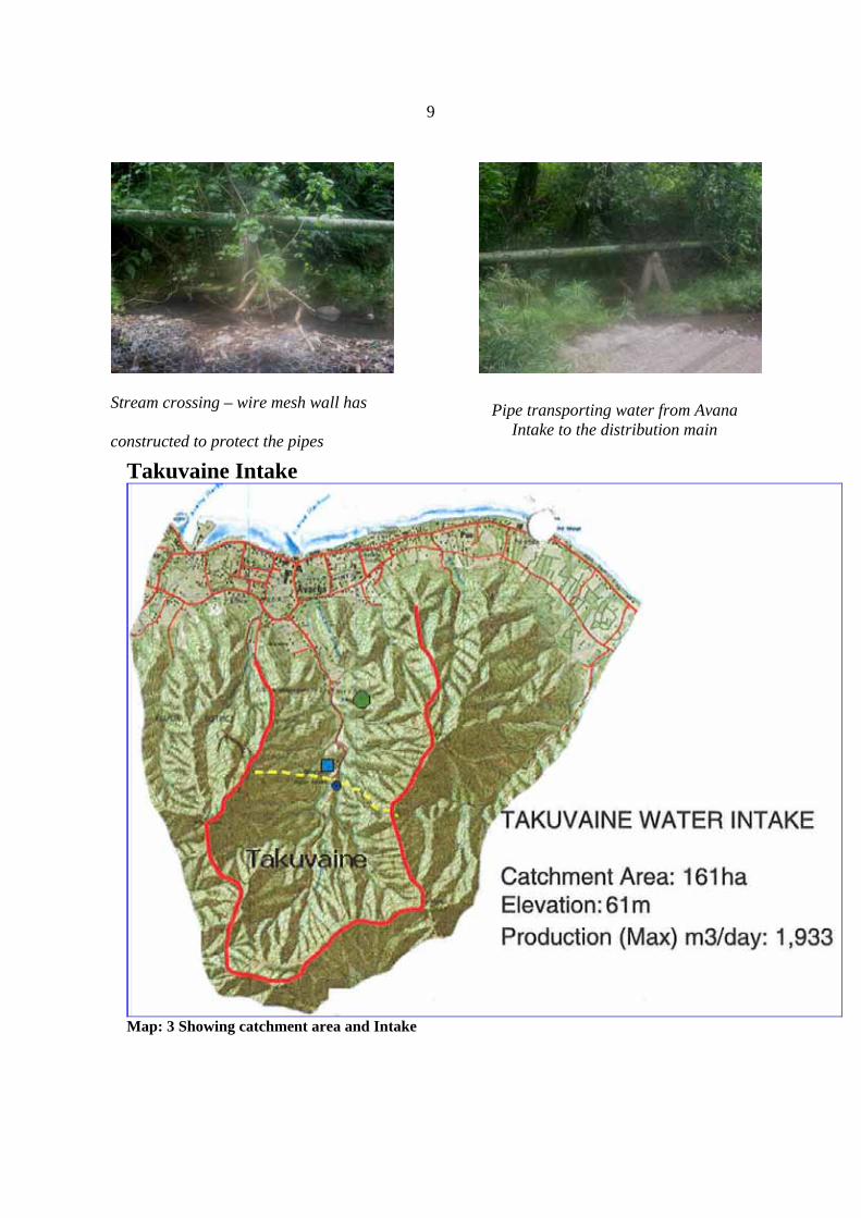
Takuvaine Intake
Map: 3 Showing catchment area and Intake
Stream crossing – wire mesh wall has
constructed to protect the pipes
Pipe transporting water from Avana Intake to the distribution main
10
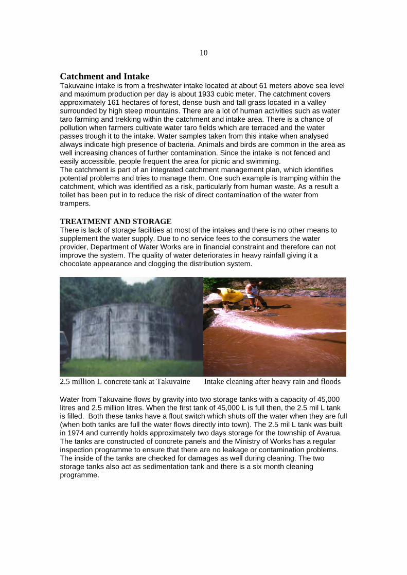
Catchment and Intake Takuvaine intake is from a freshwater intake located at about 61 meters above sea level and maximum production per day is about 1933 cubic meter. The catchment covers approximately 161 hectares of forest, dense bush and tall grass located in a valley surrounded by high steep mountains. There are a lot of human activities such as water taro farming and trekking within the catchment and intake area. There is a chance of pollution when farmers cultivate water taro fields which are terraced and the water passes trough it to the intake. Water samples taken from this intake when analysed always indicate high presence of bacteria. Animals and birds are common in the area as well increasing chances of further contamination. Since the intake is not fenced and easily accessible, people frequent the area for picnic and swimming. The catchment is part of an integrated catchment management plan, which identifies potential problems and tries to manage them. One such example is tramping within the catchment, which was identified as a risk, particularly from human waste. As a result a toilet has been put in to reduce the risk of direct contamination of the water from trampers.
TREATMENT AND STORAGE There is lack of storage facilities at most of the intakes and there is no other means to supplement the water supply. Due to no service fees to the consumers the water provider, Department of Water Works are in financial constraint and therefore can not improve the system. The quality of water deteriorates in heavy rainfall giving it a chocolate appearance and clogging the distribution system.
2.5 million L concrete tank at Takuvaine Intake cleaning after heavy rain and floods
Water from Takuvaine flows by gravity into two storage tanks with a capacity of 45,000 litres and 2.5 million litres. When the first tank of 45,000 L is full then, the 2.5 mil L tank is filled. Both these tanks have a flout switch which shuts off the water when they are full (when both tanks are full the water flows directly into town). The 2.5 mil L tank was built in 1974 and currently holds approximately two days storage for the township of Avarua. The tanks are constructed of concrete panels and the Ministry of Works has a regular inspection programme to ensure that there are no leakage or contamination problems. The inside of the tanks are checked for damages as well during cleaning. The two storage tanks also act as sedimentation tank and there is a six month cleaning programme.

11
Rarotonga- Three types of Water supply system in existence- Illustration by Davendra Nath (SOPAC) DISTRIBUTION The water is fed by gravity into the distribution system which is interconnected for the whole island. The pipe replacement works for the township of Avarua is 70% completed. There are two pumps installed to supply water to the elevated sites in Avarua. Some of the households also supplement their water by use of rain water catchment tanks which is also connected to the reticulation system. There is low water flow in the stream at times but high water loss is seen through damages in the distribution system. Due to the lack of maintenance to the system and increased infrastructure development there is high water demand. Damage to the pipe and clogging of pipes can be seen in the picture below.
Internal condition of pipes affects water quality.
Catchment Intake Distribution Consumers
Catchment
Intake
Gallery Filtration
Distribution Consumers
Catchent FilterationStorage
Distribution
Consumers
Intake
Type I
Type II
Lack of maintenance of network
Type III
12
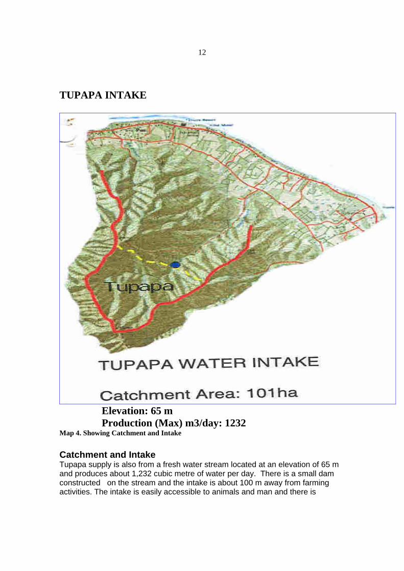
TUPAPA INTAKE
Elevation: 65 m Production (Max) m3/day: 1232 Map 4. Showing Catchment and Intake Catchment and Intake Tupapa supply is also from a fresh water stream located at an elevation of 65 m and produces about 1,232 cubic metre of water per day. There is a small dam constructed on the stream and the intake is about 100 m away from farming activities. The intake is easily accessible to animals and man and there is

13 trekking activities within the catchment. Intake for this supply is directly in the stream bed with coarsely screened and captures 90% of the stream flow. The intake is checked and cleaned three times a week as it is located in steep bush covered hills. The Tupapa stream is not known to dry up, and in times of flood the entire intake can be covered with debris.
Tupapa Filter Bed -Geo-textile material Intake -Two 100 mm PVC pipes under sand Storage and Treatment There is a small dam which collects the water and some side filtration is through Geo-textile material. There are two storage tanks for the system. Water from the intake located about 100 m uphill flows under gravity into an off stream type of filter. This filter has a small settling area and then the water passes through a geo-textile cloth. The cloth was covered with algae, which is thought to provide additional filtration (may also be a risk of toxic algae –cyanobacteria). The system was constructed in 1992 and provides approximately 15 L of water per second. The filtration system is cleaned out every three months. The water then flows through 50mm PVC pipes to a set of four Arkal filters (Refer pictures below). The filters do not use any energy and the operation of the filters is based entirely on hydraulics. These filters contain a series of metallic rings which act as filters (reported to filter down to 20 microns). The water demand and the head pressure push the water through the filters. An automatic timer can be set for backwash, but currently this is done manually. These filters are inspected three times a week and it was used as a trial for this system and if appropriate will be put on the other water intake systems. There is no chlorination of the water before it enters the distribution system. Distribution Water is fed through gravity into the distribution system which is interconnected to the main supply for the island. The pipe replacement works for the township of Avarua is still to be completed. Most of the Avarua Township is fed water under gravity; however there are two pump stations to supply water to the higher areas of Avarua. Some households supplement their reticulated supply with rainwater and keep holding tanks which are also connected to the supply.

14
CAPITAL PROJECTSTUPAPA FILTERATION
3. WATER RESOURCE MONITORING
Cook Islands predominant source of water for Rarotonga is surface water from streams and springs within the catchment valley. The water is drawn from 12 intakes located in the centre of the island. Of the supply intakes, four take the water directly; five use in-stream filtration and the reminder three use off stream intakes. The water is passed through gravel filters and gravity fed to consumers. The twelve intakes supply a total of between 7,000 to 21,000 cubic metres of water per day. Rain water harvesting is also practised in small scale by private households. The main source of water for the southern group of islands is groundwater that is reticulated from boreholes, wells, aquifers and gallery using diesel or electric pumps. Coral islands in the northern groups heavily depend on rainwater which is stored either communally or in privately owned water tanks. The Department of Water Works under the Ministry of Works (MOW) is responsible for the water supply in Rarotonga and resource monitoring. Access is generally poor to most intakes with many stream crossings involved. This makes routine inspections and maintenance more difficult. Most of the intakes are damaged from floods and start leaking thus causing loss of water which affects the supply in dry season. The blocking of intakes screens with leaves and other debris appears to be a problem especially where intakes cannot be visited on a daily basis. There maybe a more appropriate screen designs available for the covering of the intake.

15
4. Water Quality Monitoring Water quality sampling is carried out by the Environmental Health Protection Section of Cook Islands MoH, Division of Health who is responsible of all aspects of Environmental Health through out Rarotonga and the outer islands. These aspects included the management of environmental health protection, and public health awareness programs. The section is also responsible for the management of water pollution and domestic and industrial waste. Water samples are taken every 4 months and are analysed for faecal and total coliform contamination at Rarotonga Hospital Laboratory, both bacterial indicators have been detected at above guideline values in these water samples. The quality of rain water collected for drinking should also be tested. Priority parameters to be analysed are faecal coliform, E-Coli., turbidity and pH. The simple H2S to monitor the quality of the rainwater can also be utilised for the rural communities. There are many advantages of this test for use in rural and remote Pacific Island Communities where conventional water quality monitoring is difficult to be carried out. H2S tests are cheap and simple visual tests where one can notice the change in colour from pale yellow to black if there is bacterial contamination. It was revealed that the hospital lab was focussing on clinical test mainly and water analysis was done when time permits. There was one suitably qualified lab technician with Department of Water Works who did water analysis as well but there was no proper lab available so the results are questionable. (Ref to pictures below)
Rarotonga Hospital Lab (MOH) Department of Water Works Lab (MOW)

16 5. WATER DEMAND
Storage reservoirs is required to balance the system Groundwater can be utilized as a supplement It is suggested that a user pays system be initiated to generate funds necessary to supply water throughout Rarotonga for Domestic, commercial, industrial and limited agricultural use. Water is essential for the existing and developing tourism industry which Rarotonga heavily relies on. Paying for water will reduce water demands and therefore reducing the need for alternate water sources, storage facilities and other capital works. The environment also benefits by providing reducing stream abstractions that enhances in stream users. Stress on the existing surface water resources will only get worse in the future thus it is important to know the sustainable safe yield from the water supply catchment areas of Rarotonga. The only way this can be achieved is by the installation of continuous stream gauging stations to build up a database that can be used to analyse stream flow.
5% increase 10% increaseDemand - m3/day 6,000.00 6,300.00 6,600.00 Losses & Leakage - 20% 1,200.00 1,260.00 1,320.00 Global Demand - m3/day 7,200.00 7,560.00 7,920.00
Production - m3/day 6,000.00 6,000.00 6,000.00 Surplus - m3/day (1,200.00) (1,560.00) (1,920.00)
Water Production and Demand during dry season
5% increase 10% increaseDemand - m3/day 6,000.00 6,300.00 6,600.00 Losses & Leakage - 20% 1,200.00 1,260.00 1,320.00 Global Demand - m3/day 7,200.00 7,560.00 7,920.00
Production - m3/day 10,000.00 10,000.00 10,000.00 Surplus - m3/day 2,800.00 2,440.00 2,080.00
Water Production and Demand during wet season

17
13
Rarotonga Water Supply Rarotonga Water Supply –– Pipeline NetworkPipeline Network
CAPITAL PROJECTS
SANATORIUM
SANATORIUM WATER SYSTEM UPGRADING

18
3. WATER SAFETY PLANNING Water Safety Plans (WSP) can be termed as such approaches that provide most effective means of consistently ensuring the safety of drinking water supply through the use of a comprehensive risk assessment and risk management. It draws on many of the principles and concepts from other risk management approaches, in particular the multiple barrier approach (HACCP) as used in the food industry.
Growing segments of the population are continuously at risk of water borne disease through polluted drinking water, coastal and surface waters. This is compounded by the lack of information needed for resource development and protection as well as a lack of awareness of the problem associated with contaminated water. General recognition of the problem is at start, but action for increasing the capacity of Pacific Island Countries to develop and implement Water Safety Plans that address the issues is greatly needed in order to secure safe drinking water.
Water Safety Plans place emphasis on ensuring the processes used to produce safe water is controlled and function in such a way that hazards are eliminated from water before delivery to consumers. They are catchment to consumer approach, with actions taken from source protection through treatment, storage and distribution.
Steering Committee During the scoping mission a steering committee and lead agency was formed for the WSP programme. The existing Takuvaine catchment management committee established for International Waters Programme (IWP) could take on the responsibilities of the WSP National steering committee as it is essentially the right composition of the stakeholders and has the authority. The work done by the Committee on catchment management and zoning plans could be built on by a WSP. There is a good scope for WSP approach in Rarotonga for the drinking water supply.
Water Safety Planning Committee
WHO / SOPAC & NZ Experts
Possible Project Structure: Functional
Cook Is. WSP National Task Force/Steering
Committee
Water Supply Management
Water Quality Management
Catchment Management
Ministry of Works
Working Groups
NES/IWP Lessons learnt, future ‘Cloud Park’, Zoning etc
Water Quality Monitoring, Inter-agency Lab, PH
community monitoring
MoW (DWW)

19
Figure: 7 Outcomes Draft Water Safety Plans for Avana Supplies water to about 3,000 people, located inland; there is a chance for improvement of the intake. Catchment and water storage can be increased due to the increase in water demand. It is a necessary measure to be taken to reduce contamination at source. Draft Water Safety Plan for Takuvaine Supplies water to one commercial centre and the existing reserve tanks. Activities common in the catchment were subsistence taro farming. Draft Water Safety Plan for Tupapa It’s located next to Takuvaine supply intake and connected to the mains which also supply water to the commercial centres and settlements. Draft National Implementation Plan This is seen as a working document to help prepare the initial ‘Water Safety Plans’.
National Implementation Plan for Water Safety Plans Programme
Actions to assist: WSP Preparation WSP Implementation WSP Review and Evaluation
Preparing WSP Implementing WSP Reviewing outcomes of WSP
Practice at: WSP Preparation
Commitment to: WSP
Stages in Developing and Implementing a Water Safety Plans Programme
Introduction to: WSP
Reviewing outcomes of WSP Programme

20
Vanuatu National Implementation Plan
Figure: 8
Who needs to be involved? The following agencies have a key role to play in the further development of the WSP programme in Cook Islands.
• Ministry of Water Works • Ministry of Health • National Environment Service • NGOs ,Tonga Trust • Commercial Water Producers • Meteorological Department • Local Government (Vaka Council)
Vanuatu National Implementation Plan for Water Safety Plans Programme
Actions to assist: WSP Preparation
Actions to assist: WSP Implementation
Practice at: WSP Preparation
Learning about: WSP
Actions to assist: WSP Review and
Evaluation

21
Figure: 9 WEDC Pubs
WSP-WORKSHOP PARTICIPANTS IN GROUP DISCUSSSION 15/08/06 Cook Islands
Stages in Developing and Implementing Water Safety Plans
Stage 1: Forming a WSP Steering Group
Stage 2: System description and analysis
Stage 3: Tools development and pilot activities
Stage 4: System assessment
Stage 5: WSP Matrix (developing the plan)
Stage 6: Verification (water quality assessment)
Water Safety Plan
IMPLEMENT WSP

22
Risks in the Water Supply System
Figure: 10 4. Improvement Needed There is a lack of legislation, rules and standards in the water sector and the responsibilities and powers of the authorities are not closely defined. The Ministry of Health, normally the surveillance agency, has no proper strategy and collects water samples when time and transport are available. There is little or no co-operation, collaboration or exchange of information between relevant authorities. It is recommended that the government should appoint the Ministry of Health as the National Surveillance Agency giving them the necessary administrative power to perform surveillance activities. Once the new Public Health Act comes into effect, the legislative basis will be provided and the meetings of all relevant authorities should establish a monitoring and surveillance scheme to which all of the authorities agree. The Ministry of Health should perform periodical surveillance activities with sanitary inspections and water sampling in urban system and the intakes. The environmental Health Unit (EHU) should be responsible unit for surveillance activities and the overall supervision of the water quality aspects, and should develop a monitoring scheme for a short term including the chemical parameters to be monitored, sampling frequencies and inspection regimes. National Drinking Water Quality Standards are required; this will include bacteriological, physical, and chemical quality parameters and other acceptable levels in drinking water. Standardised sampling methods, sampling frequencies and analysis methods should be derived through inter-agency studies.

23
IMPROVRMENT STRATEGY NOW FUTURE
How do we get there?
Water Quality is variable e.g. dirty water through taps and low pressure
1. Secondary Treatment e.g. Tupapa Arkal filters (at least 5 microns) at all Intakes; 2. Identify systems that are low-cost (low operation and maintenance) but efficient e.g. the Arkal filters 3. Consumers install household treatment systems e.g. Filters and UV lamps
10. Water Demand & Loss needs to be ascertained;
Water Quantity is variable / not
5. Identify other sources for agricultural water use e.g. irrigation;
Water Quality is consistently good/safe
Water Quantity sustainable
4. Improve/strengthen water quality monitoring (including source water, treatment and reticulated water)
Water Demand is High (250L/pp/day)
6. Reduce water loss in the network and consumers’ system; 7. Complete Distribution network upgrade; Distribution network
100% upgraded
Less than 20% Water Loss
Inadequate Legislation / Policies
Appropriate Legislation / Policies in place for better management of drinking water supply; Develop Standards for building materials (e.g. pipes & fittings)
12. Complete Natural (or Water) Resource Management Plan;
8. Rainwater Harvesting should be promoted
11. Increase Consumer Awareness Programmes for responsible water use, conservation and fixing problems within their own property e.g. pipe breaks
13. Control Political Influence in water supply management;
14. Strengthen and build on IWP efforts for Catchment Management
Re-use of wastewater /
Improved management of
9. Desalination options

24
15. Encourage Hotels and businesses (and households) to re-use of wastewater e.g. for irrigation of farms and golf courses etc
16. Develop and implement management and protection plans for catchments for each intake
In-sufficient Funding for capital works for improving water quality and quantity
18. Identify sources (National budget, Donor Support etc) for funding capital works to improve water quality as well as quantity
Sufficient funding available to complete needed capital works
Insufficient human resource (incl. training)
21. Capacity Building Programmes need to be developed for on-going training and up-skilling of staff (DWW, NES, MoH, MoAgr, NGOs etc)
Technically competent staff available within agencies involved in water management
19. Develop Partial Cost recovery (e.g. water rates) – large consumers e.g. Hotel, Industries etc pay for water use
17. Land ownership issues are resolved (e.g. addressed through Catchment Management Plans)
Political Support not adequate
22. Promote linkages between safe drinking water quality to issues of national interest such as Public Health and Environmental Sustainability as a way to push government to increase support for drinking water supply;
Adequate Political Understanding and Support
20. Improve capacity for writing proposals for funding (either national budget or donor support)

25
5. Conclusion The Rarotonga water supply is unsatisfactory in many aspects and a lot of improvements are needed in respect to catchments, intakes, storage and treatment and finally the distribution. With tourism industry progressing there are many private and commercial users of water who are not paying for the services. The water supplier, the Ministry of Works is constrained to provide an efficient service due to the lack of funds. The government is unable to allocate necessary budget in this area and as such slow improvement is noted. There is ample surface water and ground water in Rarotonga but appropriate strategies should be in place for the protection and sustainable use. Those consumers who can afford and the commercial companies buy water but the population at large depend on the contaminated water from the distribution system. During heavy rain the water quality is worse and spread of water borne diseases is common. Monitoring and surveillance is very poor as the ministries fail to network and share information due to many reasons. The Water Safety Plan programme has raised awareness and also brought organisation together during planning stages. Due to the small South Pacific economies foreign intervention is necessary for the improvement of the water supply which in turn will improve the individual livelihood. It is
23. Political Awareness
24. Access Donor support to increase pressure on government;
25. Link Water Safety Plan to other relevant National Plans including IWP Catchment Plan and DWW
Comments to note:
• Implementation of the National Plan should be the responsibility of the National Steering Committee and should be protected from Political interference.

26
anticipated that best effort is made by the country itself to overcome the problem with available resources.
6. References 1. Binnie & Partners, 1984, Water Resource and Water Supply of Rarotonga. 2. Burke E. &Ricci SOPAC TR248 3. Country report –Cook Islands–Workshop on Drinking Water Quality Standards and
Monitoring in Pacific Island Countries, Nadi, Fiji 7-10 February 2005. 4. Geoffrey .S and Howard .G 2005 Water Safety Plans Book 1 WEDC Pub-UK 5. SOPAC/WHO Cook Islands Country Scoping Mission report 2006, Water Safety Plans
Programme-2006 6. SOPAC/WHO Cook Islands Country Workshop Report, 2006, Water Safety Plans
Programme. 7. Water Safety Plans- Planning Water Safety Management for urban water supplies in
developing countries; Godfrey. S; Howard, G; 2005. WEDC Pub ,UK. 8. Water Safety Planning in Practice-whose plan it; paper presented during the Water Safety
Plans Workshop, Suva Fiji .Gregor J, et.al 2005 Suva Fiji. 9. WHO Guidelines for Drinking Quality, 2004 Volume 1 ,Third Edition 10. Small Drinking- Water Supplies, Preparing a public health risk management plan, Ministry
of Health 2005, Wellington. 11. Thompson, C.S. 1986. The Climate and Weather of the Southern Cook Islands. NZ Met
Service Pub. 188(2) pp.69. 12. Wood L.B and Hay R.F, 1970 Geology of the Cook Islands.